Upper Southampton Township US ACOE USF&WS UNH
|
|
|
- Samson Dennis
- 5 years ago
- Views:
Transcription


1 Upper Southampton Township US ACOE USF&WS UNH 1
2 Corps of Engineers Who? Heather Jensen, Project Manager Mark Eberle, Project Biologist Sarah Apperson, Jennifer McGrath, Real Estate Rich Pearsall, public affairs Upper Southampton Township Joe Golden, Lola Biuckians, EAC USFWS Larry Brannaka Tom Ballestero, University of New Hampshire
3 Southampton Creek Restoration Project Section 206, Aquatic Ecosystem Restoration Authority Don t need addl congressional approval Cost shared 65% Federal 35% non Federal sponsor (Upper Southampton Twp.)
4 Southampton Creek Restoration Project What? Natural stream channel design Restore creek, stream banks & riparian zone to a more natural state Improve in stream habitat Why? Degraded stream, erosion, stormwater Township approached the Corps Project ID d & initiated 2001 lack of Fed funds delayed start of design How? Corps management, USFWS design, Upper Southampton Township cost sharing sponsor
5 Activities Upper Southampton Township & Corps signed a Project Partnership Agreement (PPA) for $1 million project (total cost) Upper Southampton Township will provide non Fed cost share (35%=$320K) USFWS completed conceptual design and will complete final design Corps : environmental review, real estate plan, and all other steps required prior to construction Construction is tentatively planned for the Spring of 2011 (contract must be awarded this Fall)
6 How does this affect me? Feedback Design is a dynamic process Support Real estate easements (more info later) Township responsibility Corps Real Estate experts working with Twp.
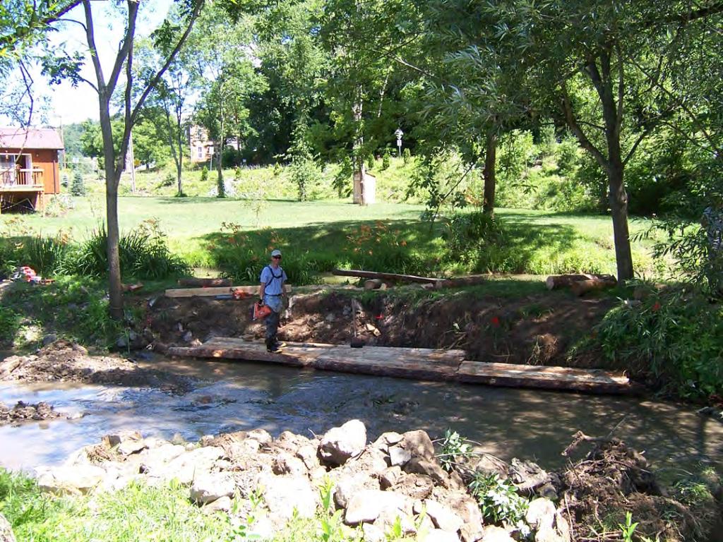
7 Geomorphic Channel Design Move water and sediment in concert with the stream form Re align the stream around constraints Structures still employed, but these are much more habitat friendly. Long term expectation is for vegetation to maintain channel horizontal alignment. 7
8 Types of Overall Solutions Put the stream back up on the floodplain Leave channel in place, and create appropriate dimensions from there Armor the system to maintain its current form Do nothing 8
9 Some Specific Solutions Re Alignment Diversion Structures Channel Blocks Log Structures Rock Structures Fiber (Coir) Mattresses Vegetation Grading Back Steep Slopes Culvert Baffles 9


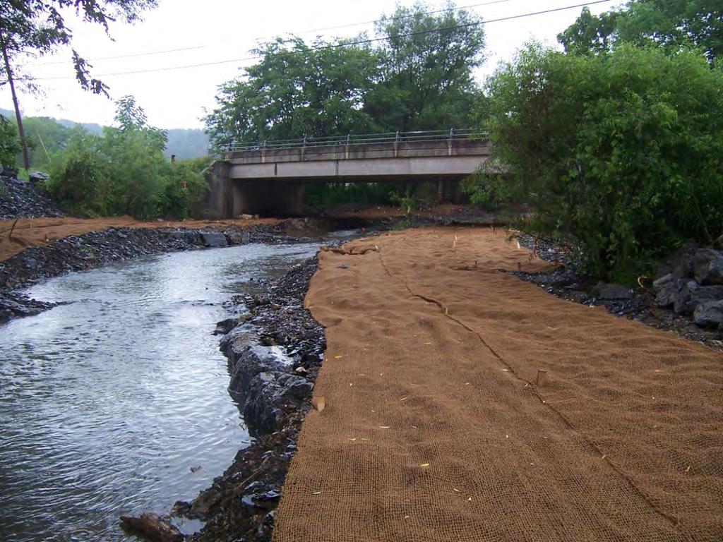
10 Southampton Creek Channel Block Stream Diversion Log Vane and Coir 10

11 Stream Diversion Location to be diverted 11


12 Stream Diversion 1 year after construction Diversion Rock Vane 12


13 Stream Diversion 2 years after construction Diversion 13


14 Re Aligned Stream Section Former alignment 14


15 The Abandoned Channel 1 Year Later Designed Wet Designed Dry 15


16 The Abandoned Channel 2 Years Later Designed Wet Designed Dry 16

17 Channel Block 2 years later 17

18 Floodplain Sill after construction 18
19 Floodplain Sill 2 years after construction 19

20 Coir Mattress 20


21 Mud Sill 21
22 Log Structures 22
23 Rock Structures 23

24 Rock Cross Vane 24


25 The Long Term Protector 25
 Perpetual Ecosystem Restoration Easement BUILDING")
26 Baltimore District Real Estate Requirements For The Southampton Creek Ecosystem Restoration Project Temporary Work Area Easement (TWAE) Perpetual Ecosystem Restoration Easement BUILDING STRONG SM 26
27 Baltimore District Understanding Easements An Easement is simply the right to use the property of another, usually to benefit adjoining lands Easements are acquired to allow the use of others properties for the such purposes as roads, pipelines, levees, flooding, flowage, etc. This easement will be similar to other common easements like utility easements BUILDING STRONG SM 27
28 Baltimore District Temporary Work Area Easement Access and staging during construction Finite term What does it mean for me, the homeowner? For the duration of the temporary easement, the workers/equipment may access the project via your property BUILDING STRONG SM 28
29 Baltimore District Perpetual Ecosystem Restoration Easement Will protect the area within the project limits with specific language Easement allows Township to maintain and care for project area What does it mean for me, the homeowner? There will be restrictions within the easement area so that the project area can be properly protected and maintained BUILDING STRONG SM 29
30 Baltimore District Easements continued Who will be acquiring the necessary easements? The Township, not the Army Corps of Engineers, will be acquiring the appropriate easement from you, the homeowner Will I still own the land? You will still own the land identified as needed for the project in fee. The easement only restricts activities for the protection of the project area on a portion of the parcel, not the entire parcel itself Why is the Perpetual Ecosystem Restoration Easement restrictive? To minimize negative human impact and minimize natural degradation BUILDING STRONG SM 30
31 Baltimore District Potential collaboration with Pennypack Watershed Partnership Assistance with plantings Assistance with ecological monitoring (pre and post construction for 5 years) Macroinvertebrate (aquatic insect) monitoring Taking photos and monitoring vegetation BUILDING STRONG SM 31
Appendix G. Non-Federal Letters of Support and Draft Real Estate Plan
 Appendix G Non-Federal Letters of Support and Draft Real Estate Plan REAL ESTATE PLAN UPPER DELAWARE RIVER WATERSHED FEASABILITY STUDY LIVINGSTON MANOR, NEW YORK 1. GENERAL 2. REAL ESTATE REQUIREMENTS
APPENDIX D - REAL ESTATE
 APPENDIX D - REAL ESTATE 1. Purpose Real Estate Plan For Feasibility Study For Lake Lou Yaeger Section 206 Aquatic Ecosystem Restoration Continuing Authorities Project Feasibility Study This report is
Draft Continuing Authorities Program Section 1135 Detailed Project Report and Integrated Environmental Assessment
 Appendix G Real Estate Shorty s Island / Meander Reach Ecosystem Restoration Kootenai River, Idaho Draft Continuing Authorities Program Section 1135 Detailed Project Report and Integrated Environmental
Appendix B Draft Real Estate Plan
 Appendix B Draft Real Estate Plan B-1 REAL ESTATE PLAN Prepared for U.S. Army Corps of Engineers Southwestern Division Little Rock District As of December 3, 2012 Prepared by Ronald Bridges Real Estate
Mitigation and Conservation Banking
 Mitigation and Conservation Banking Ryan Orndorff Headquarters, Marine Corps Marine Corps Installations Command 571-256-2782 ryan.orndorff@usmc.mil Definitions, Policies & Guidelines Existing banks and
DRAINAGE EASEMENT & MAINTENANCE AGREEMENT
 DRAINAGE EASEMENT & MAINTENANCE AGREEMENT THIS DRAINAGE EASEMENT & MAINTENANCE AGREEMENT (this Easement ) is granted this day of, 20, by, [husband and wife/trustee, etc.], whose address is (the Grantor
DEPARTMENT OF THE ARMY OFFICE OF THE CHIEF OF ENGINEERS WASHINGTON, D.C
 DEPARTMENT OF THE ARMY OFFICE OF THE CHIEF OF ENGINEERS WASHINGTON, D.C. 20314-1000 REPLY TO ATTENTION OF: CECW-PM (10-1-7a) THE SECRETARY OF THE ARMY 1. I submit for transmission to Congress my report
Resource Protection Area Map Update - Frequently Asked Questions
 DEPARTMENT OF ENVIRONMENTAL SERVICES Office of Sustainability and Environmental Management 2100 Clarendon Boulevard, Suite 705, Arlington, VA 22201 TEL 703-228-4488 FAX 703-228-7134 TTY 703-228-4611 www.arlingtonva.us
Zoning Permit Application
 Zoning Permit Application FOR OFFICE USE ONLY Date Payment Form Amount Receipt # Clerk Required Submittals (circle if presented with application) Incomplete applications may be returned and/or delayed.
Gates County Planning and Zoning
 Gates County Planning and Zoning PO Box 411, 200 Court Street, Gatesville, NC 27938 phone: 252-357-2411 fax: 252-357-0073 Application for Technical Review Committee For Staff Use Only: Date: Application
UPPER MISSISSIPPI RIVER RESTORATION FEASIBILITY REPORT WITH INTEGRATED ENVIRONMENTAL ASSESSMENT
 UPPER MISSISSIPPI RIVER RESTORATION FEASIBILITY REPORT WITH INTEGRATED ENVIRONMENTAL ASSESSMENT McGregor Lake HABITAT REHABILITATION AND ENHANCEMENT PROJECT POOL 10, UPPER MISSISSIPPI RIVER MILE 635-634
A. ARTICLE 16 - STEEP SLOPE CONSERVATION DISTRICT
 1600. 1601.A. ARTICLE 16 - STEEP SLOPE CONSERVATION DISTRICT SECTION 1600 PURPOSE The purpose of this Article is to expand upon the Community Development Objectives associated with environmental protection
CITY OF FORT COLLINS NATURAL AREAS AND CONSERVED LANDS EASEMENT POLICY
 CITY OF FORT COLLINS NATURAL AREAS AND CONSERVED LANDS EASEMENT POLICY Adopted January 3, 2012 PURPOSE: The purpose of the policy statement is to clarify the policies and procedures of the City of Fort
Application Procedures for Easements or Rights of Way on City of Fort Collins Natural Areas and Conserved Lands March 2012
 Application Procedures for Easements or Rights of Way on City of Fort Collins Natural Areas and Conserved Lands March 2012 IMPORTANT NOTE: This document was created to accompany the City of Fort Collins
Biodiversity Planning Policy and Guidelines for (LEP) Rezoning Proposals
 Rezoning Proposals") Council Policy Biodiversity Planning Policy and Guidelines for (LEP) Rezoning Proposals Table of Contents Table of Contents... 1 Policy... 2 Policy Objectives... 2 Policy Statement... 2 Guidelines... 2
Council Policy Biodiversity Planning Policy and Guidelines for (LEP) Rezoning Proposals Table of Contents Table of Contents... 1 Policy... 2 Policy Objectives... 2 Policy Statement... 2 Guidelines... 2
Appendix B Real Estate Plan
 Appendix B Real Estate Plan B-1 REAL ESTATE PLAN Prepared for U.S. Army Corps of Engineers Southwestern Division Little Rock District As of May 1, 2013 Prepared by Ronald Bridges Real Estate Division ANY
CHAPTER 6 CHESAPEAKE BAY PRESERVATION AREAS AND STREAM PROTECTION AREAS
 CHAPTER 6 CHESAPEAKE BAY PRESERVATION AREAS AND STREAM PROTECTION AREAS 6.1 INTRODUCTION Virginia s Chesapeake Bay Preservation Area (CBPA) Designation and Management Regulations (9VAC10-20 et seq.) require
MINOR & MAJOR SUBDIVISION APPLICATION
 TOW OF HOOKSETT APPLICATIO # DATE MIOR & MAJOR SUBDIVISIO APPLICATIO Application for: Completeness Map and Lot o. Public Hearing o. of Lots LOCATIO: (Specify Street Address) OWER: APPLICAT: ADDRESS: ADDRESS:
REGULAR FINAL PLAT SUBDIVISION APPLICATION
 REGULAR FINAL PLAT SUBDIVISION APPLICATION Name of Subdivision (Subdivision Name must be approved by at 856-6216) ( )Cluster Subdivision ( )Lot-by-Lot Subdivision ( )Open Space Subdivision Name of Subdivision
APPENDIX H REAL ESTATE REQUIREMENTS
 Malden River Ecosystem Restoration Detailed Project Report APPENDIX H REAL ESTATE REQUIREMENTS April 2007 Malden River Ecosystem Restoration Real Estate Report 1. PURPOSE: The Detailed Project Report
Paintbrush North Siesta/Paintbrush Corridor Meeting. Saturday May 5, :00 4:00 PM
 Paintbrush North Siesta/Paintbrush Corridor Meeting Saturday May 5, 2012 2:00 4:00 PM Welcome and Introductions Supervisor Liz Archuleta District 2 Coconino County 2 Opening Remarks Natural Resources Conservation
Article III. Erosion and Sedimentation Control
 Article III. Erosion and Sedimentation Control Section 9.6 Erosion and Sedimentation Control Plan Requirements Section 9.6.1 Plan Submission A plan shall be prepared for all land-disturbing activities
PERMIT APPLICATION FORM
 CVCA File #: P.O. Box 416, 70 Hughes Lane, Marmora, ON K0K 2M0 Tel: 613-472-3137 Fax: 613-472-5516 www.crowevalley.com PERMIT APPLICATION FORM FOR A DEVELOPMENT, INTERFERENCE WITH WETLANDS AND ALTERATIONS
Creek Rehabilitation Plan for Apple Valley Questions and Answers from the Pre-Bid Meeting and Site Visit 06/23/2016
 Questions and Answers from the Pre-Bid Meeting and Site Visit 06/23/2016 Q: What are the threatened and endangered species concerns in the area? A: This is potential habitat for Prebles Meadow Jumping
CHAPTER 3 PRELIMINARY PLAT
 10-3-1 10-3-3 SECTION: CHAPTER 3 PRELIMINARY PLAT 10-3-1: Consultation 10-3-2: Filing 10-3-3: Requirements 10-3-4: Approval 10-3-5: Time Limitation 10-3-6: Grading Limitation 10-3-1: CONSULTATION: Each
City of Palo Alto (ID # 4882) City Council Staff Report
 City Council Staff Report") City of Palo Alto (ID # 4882) City Council Staff Report Report Type: Consent Calendar Meeting Date: 12/15/2014 Summary Title: Easements for San Francisquito Creek Joint Powers Authority Initial Flood Protection
City of Palo Alto (ID # 4882) City Council Staff Report Report Type: Consent Calendar Meeting Date: 12/15/2014 Summary Title: Easements for San Francisquito Creek Joint Powers Authority Initial Flood Protection
Environmental Credit Offsets: Not Just for Wetlands Transportation Engineers Association of Missouri
 Environmental Credit Offsets: Not Just for Wetlands Transportation Engineers Association of Missouri March 8, 2018 WHAT IS MITIGATION? Mitigation is the third step in an environmental sequence First step:
SECTION 4: PRELIMINARY PLAT
 SECTION 4: PRELIMINARY PLAT After the completion of the sketch plan process, if submitted, the owner or developer shall file with the City an application for preliminary plat. The preliminary plat stage
March 25, Wet Weather Community Engagement Board of Directors Workshop. What are our requirements? 8/28/2015
 Wet Weather Community Engagement Board of Directors Workshop March 25, 2015 Nine Minimum Controls NMC 7 Pollution Prevention NMC 8 Public Notification Partial Consent Decree CSO Signage CSO Notification
Schedule "A Fees (Planning Advisory Program)
") Approvals Fee Schedule (Effective January 1, 2018) Schedule "A Fees (Planning Advisory Program) - 2018 Planning Application Type Fee is for provision of comments to municipal approval authority on site
Approvals Fee Schedule (Effective January 1, 2018) Schedule "A Fees (Planning Advisory Program) - 2018 Planning Application Type Fee is for provision of comments to municipal approval authority on site
All roads developed to access four (4) or more parcels shall be constructed to Park County Road and Bridge Standards.
 or more parcels shall be constructed to Park County Road and Bridge Standards.") P a r k C o u n t y P l a n n i n g a n d Z o n i n g 1002 Sheridan Avenue Cody, WY 82414 Phone: 307-527-8540 35-40 ACRE SUBDIVISIONS www.parkcounty.us/planandzone.htm May 2011 This is only intended as
P a r k C o u n t y P l a n n i n g a n d Z o n i n g 1002 Sheridan Avenue Cody, WY 82414 Phone: 307-527-8540 35-40 ACRE SUBDIVISIONS www.parkcounty.us/planandzone.htm May 2011 This is only intended as
Open Space Model Ordinance
 Open Space Model Ordinance Section I. Background Open space development has numerous environmental and community benefits, including: 1) Reduces the impervious cover in a development. Impervious cover
Residential Major Subdivision Review Checklist
 Residential Major Subdivision Review Checklist Plan Submittal Requirements: 2 full sets of stamped plans Electric submittal - all plans contained in a single PDF 3 full sets if commercial kitchen or dining
Town of Falmouth s Four Step Design Process for Subdivisions in the Resource Conservation Zoning Overlay District
 Town of Falmouth s Four Step Design Process for Subdivisions in the Resource Conservation Zoning Overlay District All subdivisions shall be designed in accordance with the following four-step process.
Appendix K. Real Estate Plan
 Appendix K. Real Estate Plan REAL ESTATE PLAN DELTA ISLANDS AND LEVEES FEASIBILITY STUDY (DELTA STUDY) 20 June 2018 PREPARED BY THE SACRAMENTO DISTRICT U.S. ARMY CORPS OF ENGINEERS 1 TABLE OF CONTENTS
NOTICE DATE: August 19, Joint Public Notice. U.S. Army Corps of Engineers and State of Arkansas
 US Army Corps of Engineers Memphis District Public Notice FILE NUMBER: MVM-2013-182 (RCW) NOTICE DATE: August 19, 2013 Attn: Postmaster, Please Post Until EXPIRATION DATE: September 18, 2013 Joint Public
UPPER MISSISSIPPI RIVER RESTORATION FEASIBILITY REPORT WITH INTEGRATED ENVIRONMENTAL ASSESSMENT
 UPPER MISSISSIPPI RIVER RESTORATION FEASIBILITY REPORT WITH INTEGRATED ENVIRONMENTAL ASSESSMENT BEAVER ISLAND HABITAT REHABILITATION AND ENHANCEMENT PROJECT POOL 14, UPPER MISSISSIPPI RIVER MILES 513.0-517.0
Implementation Tools for Local Government
 Information Note #5: Implementation Tools for Local Government This Information Note is a guide only. It is not a substitute for the federal Fisheries Act, the provincial Riparian Areas Regulation, or
APPENDIX C REAL ESTATE PLAN BOULEVARD RESACA, BROWNSVILLE, TX CAMERON COUNTY, TEXAS
 APPENDIX C REAL ESTATE PLAN BOULEVARD RESACA, BROWNSVILLE, TX CAMERON COUNTY, TEXAS November 19, 2016 Table of Contents Purpose... 3 Project Authority... 3 Project Location and Description... 3 Non-Federal
VI. SAFETY ELEMENT I. INTRODUCTION A. PURPOSE B. AUTHORITY. 1. Safety
 AB 162 and SB 1241 Amendment to the Safety Element New sections are underlined, deleted sections are shown as strikethrough and the denotes text remaining in place. VI. SAFETY ELEMENT I. INTRODUCTION A.
DRAFT INTEGRATED FEASIBILITY REPORT AND ENVIRONMENTAL ASSESSMENT
 APPENDIX E REAL ESTATE PLAN MT. SINAI MEDICAL CENTER, CONTINUTING AUTHORITIES PROGRAM (CAP) SECTION 14, PROJECT DRAFT INTEGRATED FEASIBILITY REPORT AND ENVIRONMENTAL ASSESSMENT September 2016 DRAFT APPENDIX
Georgia Conservation Tax Credit Program Frequently Asked Questions
 Georgia Conservation Tax Credit Program Frequently Asked Questions What are the minimum requirements for eligibility under the Georgia Conservation Tax Credit Program (GCTCP)? Individual and corporate
GOVERNMENT CODE SECTION GOVERNMENT CODE SECTION 65302
 GOVERNMENT CODE SECTION 65300 65300. Each planning agency shall prepare and the legislative body of each county and city shall adopt a comprehensive, long-term general plan for the physical development
FRESHWATER WETLANDS PROTECTION IN NEW JERSEY Tools for Municipal Action
 FRESHWATER WETLANDS PROTECTION IN NEW JERSEY Tools for Municipal Action The Freshwater Wetlands Protection Act INTENT OF FRESHWATER WETLANDS LAW The New Jersey legislature passed the Freshwater Wetlands
PROJECT SCOPE OF WORK CITY OF TOWN AND COUNTRY STORMWATER PROGRAM
 PROJECT SCOPE OF WORK CITY OF TOWN AND COUNTRY STORMWATER PROGRAM Project ID Number: 2-2 Problem: The backyards at 962, 97, and 978 Delvin Drive are located in a low area of shallow ponding that takes
Skagit River Flood Risk Management General Investigation Skagit County, Washington. Draft Feasibility Report and Environmental Impact Statement
 General Investigation Skagit County, Washington Draft Feasibility Report and Environmental Impact Statement May 2014 Real Estate Requirements of Selected Plan This Real Estate Plan Summary (REP) is presented
LAKE OF THE WOODS COUNTY WETLAND CONSERVATION ORDINANCE OF 2002
 Ordinance # LAKE OF THE WOODS COUNTY WETLAND CONSERVATION ORDINANCE OF 2002 ARTICLE 1 TITLE AND PURPOSE Section 1.1. Title This Ordinance shall be known, cited and referred to as the Lake of the Woods
Department of Legislative Services Maryland General Assembly 2010 Session
 Department of Legislative Services Maryland General Assembly 2010 Session SB 1128 FISCAL AND POLICY NOTE Revised Senate Bill 1128 (Senator Colburn) Education, Health, and Environmental Affairs Environmental
BRISTOL CONSERVATION COMMISSION INLAND WETLANDS AGENCY FORM IW-1 (Application for a Wetlands Permit)
") APPLICATION NO. BRISTOL CONSERVATION COMMISSION INLAND WETLANDS AGENCY FORM IW-1 (Application for a Wetlands Permit) DATE FILED: APPROVED: DENIED: 1. APPLICANT: Name: Signature: Address: City: State: Zip
APPLICATION NO. BRISTOL CONSERVATION COMMISSION INLAND WETLANDS AGENCY FORM IW-1 (Application for a Wetlands Permit) DATE FILED: APPROVED: DENIED: 1. APPLICANT: Name: Signature: Address: City: State: Zip
SPECIAL PUBLIC NOTICE
 SPECIAL PUBLIC NOTICE U.S. ARMY CORPS OF ENGINEERS BUILDING STRONG LOS ANGELES DISTRICT APPLICATION FOR PERMIT Coachella Valley In-Lieu Fee Program Public Notice/Application No.: SPL-2013-00324-TOB Project:
HUNTING BAYOU FLOOD RISK MANAGEMENT, HARRIS COUNTY, TEXAS DRAFT GENERAL REEVALUATION REPORT AND INTEGRATED ENVIRONMENTAL ASSESSMENT
 HUNTING BAYOU FLOOD RISK MANAGEMENT, HARRIS COUNTY, TEXAS DRAFT GENERAL REEVALUATION REPORT AND INTEGRATED ENVIRONMENTAL ASSESSMENT APPENDIX 6 REAL ESTATE PLAN June 2014 HARRIS COUNTY FLOOD CONTROL DISTRICT
Emergency Watershed Program Sandy Recovery Activities and Flood Plain Easement Program
 Emergency Watershed Program Sandy Recovery Activities and Flood Plain Easement Program Greg Westfall, Resource Conservationist USDA-Natural Resources Conservation Service (NRCS) Set up by Congress to respond
SACRAMENTO COUNTY WATER AGENCY ORDINANCE NO. WA0-0089
 SACRAMENTO COUNTY WATER AGENCY ORDINANCE NO. WA0-0089 AN ORDINANCE OF THE SACRAMENTO COUNTY WATER AGENCY CODE RELATING TO THE NORTH VINEYARD STATION SUPPLEMENTAL DRAINAGE FEE The Board of Directors of
MARK TWAIN LAKE MASTER PLAN CLARENCE CANNON DAM AND MARK TWAIN LAKE MONROE CITY, MISSOURI
 MARK TWAIN LAKE MASTER PLAN CLARENCE CANNON DAM AND MARK TWAIN LAKE MONROE CITY, MISSOURI CHAPTER 4 LAND ALLOCATION, LAND CLASSIFICATION, WATER SURFACE, AND EASEMENT LANDS This Master Plan is a land use
Napa County Planning Commission Board Agenda Letter
 Agenda Date: 9/20/2017 Agenda Placement: 8C Napa County Planning Commission Board Agenda Letter TO: FROM: Napa County Planning Commission Charlene Gallina for David Morrison - Director Planning, Building
BUILDING PERMIT / ZONING USE PERMIT APPLICATION
 Date Received Zoning District: UPPER MILFORD TOWNSHIP ~ LEHIGH COUNTY, PA Permit No. Pin No. BUILDING PERMIT / ZONING USE PERMIT APPLICATION CONTACT INFORMATION: Check who is responsible for permit. Site
Sean Rafferty. Lake Erie Coastal Outreach Specialist Pennsylvania Sea Grant
 Sean Rafferty Lake Erie Coastal Outreach Specialist Pennsylvania Sea Grant Crown Point Subdivision: Characteristics Site Design Development Cost Benefits Harborcreek Township Regulations: Comprehensive
A. Maintenance. All legally established, nonconforming structures can be maintained (e.g., painting and repairs);
;") Chapter 24.50 NONCONFORMING USES, STRUCTURES AND LOTS Sections: 24.50.010 Nonconforming uses, structures, and lots Purpose. 24.50.020 Nonconforming uses, structures, and lots Alteration or expansion of
Chapter 24.50 NONCONFORMING USES, STRUCTURES AND LOTS Sections: 24.50.010 Nonconforming uses, structures, and lots Purpose. 24.50.020 Nonconforming uses, structures, and lots Alteration or expansion of
River Rock Estates Sketch Plan, a proposed major subdivision in S24, T35N R2W NMPM on County Rd 119 (PLN18-336)
") MEMORANDUM Archuleta County Development Services Planning Department 1122 HWY 84 P. O. Box 1507 Pagosa Springs, Colorado 81147 970-264-1390 Fax 970-264-3338 TO: Archuleta County Planning Commission FROM:
MEMORANDUM Archuleta County Development Services Planning Department 1122 HWY 84 P. O. Box 1507 Pagosa Springs, Colorado 81147 970-264-1390 Fax 970-264-3338 TO: Archuleta County Planning Commission FROM:
KINGWOOD TOWNSHIP BOARD OF ADJUSTMENT. MINUTES May 11, :30 PM
 KINGWOOD TOWNSHIP BOARD OF ADJUSTMENT MINUTES May 11, 2016 7:30 PM CALL TO ORDER The meeting was called to order by M.L. Haring at 7:31 PM. PRESENT: T. Ciacciarelli ABSENT: L. Frank M.L. Haring J. Laudenbach
Deb Grube Walworth County Land Use and Resource Management
 Deb Grube dgrube@co.walworth.wi.us 262-741-7907 Walworth County Land Use and Resource Management www.co.walworth.wi.us County Zoning Contacts: Deb Grube (262) 741-7907 Board of Adjustment, Mobile Towers
Conservation Easement Stewardship
 Conservation Easements are effective tools to preserve significant natural, historical or cultural resources. Conservation Easement Stewardship Level of Service Standards March 2013 The mission of the
CITY OF CORNING TENTATIVE MAPS
 CITY OF CORNING TENTATIVE MAPS APPLICANT S GUIDE TO PROCEDURES WHAT IS A TENTATIVE MAP? A division of land for the purpose of sale, lease, or finance requires submittal of a map for City approval showing
Conceptual Scheme SE W4
 December 2012 1. PURPOSE 1.1. The purpose of a Conceptual Scheme (CS) is as follows: a) To provide a framework for the subsequent subdivision and/or development of land within the Country Residential Policy
APPENDIX G REAL ESTATE
 BUBBLY CREEK, SOUTH BRANCH OF THE CHICAGO RIVER, ILLINOIS FEASIBILITY STUDY APPENDIX G REAL ESTATE DRAFT - NOT FOR DISTRIBUTION APRIL 2015 U.S. Army Corps of Engineers Chicago District Appendix G Real
SECTION 10: FLOOD HAZARD EVALUATION 10-1
 10) SECTION 10: FLOOD HAZARD EVALUATION A. General. Land subject to being flooded by a Flood of 100-Year Frequency as defined by Title 76, Chapter 5, MCA, or land subject to flooding pursuant to these
Conceptual Scheme SE W4
 Conceptual Scheme September 2014 Conceptual Scheme 1. PURPOSE 1.1. The purpose of a Conceptual Scheme (CS) is as follows: a) To provide a framework for the subsequent subdivision and/or development of
Municipality of Anchorage, Alaska Parks & Recreation Department
 Municipality of Anchorage, Alaska Parks & Recreation Department 632 W. 6 th Avenue, Suite 630 P.O. Box 196650 Anchorage, AK 99519 Tel 907-343-4355 URL www.muni.org/departments/parks MEMORANDUM Date: September
City Of Attleboro Conservation Commission
 City Of Attleboro Conservation Commission GOVERNMENT CENTER, 77 PARK STREET ATTLEBORO, MASSACHUSETTS 02703 (508) 223 2222 FAX 222 3046 GENERAL INSTRUCTIONS AND CHECKLIST FOR COMPLETING STORMWATER MANAGEMENT
MONTHLY MEETING HI- COUNTRY ESTATES II HOMEOWNERS ASSOCIATION MARCH 28, 2009
 MONTHLY MEETING HI- COUNTRY ESTATES II HOMEOWNERS ASSOCIATION MARCH 28, 2009 Infrastructure deterioration can be reversed and expansions of systems to serve new development are possible but all solutions
TRANSFERABLE DEVELOPMENT RIGHTS PROCESS GUIDE
 TRANSFERABLE DEVELOPMENT RIGHTS PROCESS GUIDE Clear Creek County Planning Department P.O. Box 2000 Georgetown, Colorado 80444 (303) 679-2436 - phone (303) 569-1103 - fax 1 PURPOSE: A Transfer of Development
JOINT PUBLIC NOTICE PUBLIC NOTICE
 Albuquerque District JOINT PUBLIC NOTICE PUBLIC NOTICE Application Number: SPA-2012-00299-ABQ Date: October 20, 2014 Comments Due: November 20, 2014 SUBJECT: The U.S. Army Corps of Engineers, Albuquerque
COUNTY OF SACRAMENTO CALIFORNIA
 COUNTY OF SACRAMENTO CALIFORNIA Control No.: PLNP2007-00537 Type: PMR TO: FROM: SUBJECT: SUBDIVISION REVIEW COMMITTEE PLANNING AND COMMUNITY DEVELOPMENT DEPARTMENT CHRIS BOTTIMORE TENTATIVE PARCEL MAP
Brief Summary of Drainage Law. November 2011
 Brief Summary of Drainage Law November 2011 This document is general information distributed by the State of South Dakota. Nothing in this document should be considered legal advice as to any specific
Using Easements to Conserve Biodiversity. Jeff Lerner Defenders of Wildlife
 Using Easements to Conserve Biodiversity Jeff Lerner Defenders of Wildlife jlerner@defenders.org Northeast LTA June 10, 2006 Defenders of Wildlife Mission: to protect native wild animals and plants in
DRAFT REAL ESTATE PLAN APPENDIX D JEFFERSON COUNTY ECOSYSTEM RESTORATION FEASIBILITY STUDY
 DRAFT REAL ESTATE PLAN APPENDIX D JEFFERSON COUNTY ECOSYSTEM RESTORATION FEASIBILITY STUDY (NOTE: This page intentionally left blank.) This Real Estate Plan has been prepared in accordance with ER 405-1-12
House site, means the approximate foot print of an existing or proposed residential building within the buildable area of a lot.
 ARTICLE V. CONSERVATION SUBDIVISION Sec. 50-137. Definitions. Estate lot a lot with a minimum area of 3 acres that is intended for one principal single-family detached dwelling and may include accessory
Frequently Asked Questions for: Drainage, Watershed and Water Quality Property Owners Near Creeks Developers and Engineers and Definitions of Terms
 FREQUENTLY ASKED QUESTIONS Draft DEFINITIONS OF TERMS Last Revised July 2, 2008 Introduction: The following questions have been organized in the categories below. We have attempted to group the questions
Residential Minor Subdivision Review Checklist
 Residential Minor Subdivision Review Checklist Plan Submittal Requirements: 2 full sets of stamped plans Electric submittal - all plans contained in a single PDF 3 full sets if commercial kitchen or dining
Zoning/Building Permit Application
 Zoning/Building Permit Application Location Address: Zoning District: Parcel #: -0626 Subdivision Name: Lot Size: CONTACT INFORMATION: Applicant s Name Address _ Email Owner s Name Address _ Email Professional
JOINT PUBLIC NOTICE CORPS OF ENGINEERS STATE OF ARKANSAS Application Number: Date: December 9, 2016 Comments Due: January 3, 2017
 US Army Corps of Engineers Little Rock District JOINT PUBLIC NOTICE CORPS OF ENGINEERS STATE OF ARKANSAS Application Number: 2016-00183-1 Date: December 9, 2016 Comments Due: January 3, 2017 TO WHOM IT
***** Subchapter A. GENERAL PROVISIONS ***** PERMIT APPLICATIONS
 105.11. Permit requirements. 105.12. Waiver of permit requirements. Title 25 Environmental Protection Part I. Department of Environmental Protection Subpart C. Protection of Natural Resources Article I.
Using Affirmative Covenants in Conservation Easements
 Using Affirmative Covenants in Conservation Easements Conservation Law Forum 2017 CCLT March 9 Ellen Fred Stephanie Tavares-Buhler Crystal Simons Affirmative covenants illustrated three ways: Agricultural
ARTICLE 5 MINOR SUBDIVISION/LAND DEVELOPMENT
 ARTICLE 5 MINOR SUBDIVISION/LAND DEVELOPMENT SECTION 501 ONLY FINAL PLAN REQUIRED The classification of a proposed subdivision as a "Minor Subdivision" shall only require the submission, review and approval
COASTAL CONSERVANCY. Staff Recommendation January 18, Carmel River Parkway Acquisitions. File No Project Manager: Trish Chapman
 COASTAL CONSERVANCY Staff Recommendation January 18, 2006 Carmel River Parkway Acquisitions File No. 06-104 Project Manager: Trish Chapman RECOMMENDED ACTION: Authorization to disburse up to $3,500,000
Lilly Creek Improvement Project
 Part 1 Lilly Creek Improvement Project What is Lilly Creek? Lilly Creek is an open-air, private stormwater drainage system which collects surface water from western Greene County and eastern Montgomery
REPORT CENTRAL LAKE ONTARIO CONSERVATION AUTHORITY
 REPORT CENTRAL LAKE ONTARIO CONSERVATION AUTHORITY DATE: May 13, 2013 FILE: O13-036-GH IMS: RPRG4186 S.R.: 5147-13 APPROVED BY C.A.O. MEMO TO: FROM: SUBJECT: Chair and Members, CLOCA Board of Directors
Subdivision - Application
 Planning and Development Services, 2001 Sherwood Drive, Sherwood Park, AB T8A 3W7 Phone 780-464-8080 Fax 780-464-8109 Email: Landuse&policyplanning@strathcona.ca (Page 1 of 5) This form is to be completed
TOWN OF LAKE LURE LAND DISTURBANCE PERMIT (LESS THAN 1 ACRE) Permit Fee Permit No. LDP- (see Fee Schedule below) Approved:
 Permit Fee Permit No. LDP- (see Fee Schedule below) Approved:") TOWN OF LAKE LURE LAND DISTURBANCE PERMIT (LESS THAN 1 ACRE) Permit Fee Permit No. LDP- (see Fee Schedule below) Approved: Expiration Date: Erosion Control Officer Rejected: (see attached explanation)
TOWN OF LAKE LURE LAND DISTURBANCE PERMIT (LESS THAN 1 ACRE) Permit Fee Permit No. LDP- (see Fee Schedule below) Approved: Expiration Date: Erosion Control Officer Rejected: (see attached explanation)
Project Pre-Application
 Pre Application Due Date: Tues, March 5 2013 Draft Application Due Date: Tues, April 30, 2013 Final Application Due Date: Thurs, July 11, 2013 Project Pre-Application (Please use the Up, Down, Left & Right
Environment and Natural Resources Trust Fund Request for Proposals (RFP)
") Environment and Natural Resources Trust Fund 2012-2013 Request for Proposals (RFP) Project Title: Southeast Minnesota Sensitive Habitat Protection Program (SHPP) ENRTF ID: 067-D Topic Area: D. Land Acquisition
Environment and Natural Resources Trust Fund 2012-2013 Request for Proposals (RFP) Project Title: Southeast Minnesota Sensitive Habitat Protection Program (SHPP) ENRTF ID: 067-D Topic Area: D. Land Acquisition
Draft Environmental Impact Statement (EIS)/Environmental Impact Report (EIR) APPENDIX H Real Estate Cost
/Environmental Impact Report (EIR) APPENDIX H Real Estate Cost") Draft Environmental Impact Statement (EIS)/Environmental Impact Report (EIR) APPENDIX H Real Estate Cost US Army Corps of Engineers Corte Madera Creek Flood Risk Management Project October 2018 APPENDIX
Draft Environmental Impact Statement (EIS)/Environmental Impact Report (EIR) APPENDIX H Real Estate Cost US Army Corps of Engineers Corte Madera Creek Flood Risk Management Project October 2018 APPENDIX
Planning Justification Report
 Planning Justification Report, Township of Puslinch FARHI HOLDINGS CORPORATION Updated January 27, 2017 Zelinka Priamo Ltd. Page i TABLE OF CONTENTS Page No. 1.0 1.1 1.2 1.3 2.0 2.1 2.2 2.3 2.4 2.5 3.0
YCCD EROSION & SEDIMENT POLLUTION CONTROL (E&SPC) PROGRAM SERVICES FEE SCHEDULE, RULES, & GUIDELINES
 PROGRAM SERVICES FEE SCHEDULE, RULES, & GUIDELINES") YCCD EROSION & SEDIMENT POLLUTION CONTROL (E&SPC) PROGRAM SERVICES FEE SCHEDULE, RULES, & GUIDELINES Adopted by the YCCD Board of Directors on December 14, 2018 Effective January 1, 2019. I. Authority
YCCD EROSION & SEDIMENT POLLUTION CONTROL (E&SPC) PROGRAM SERVICES FEE SCHEDULE, RULES, & GUIDELINES Adopted by the YCCD Board of Directors on December 14, 2018 Effective January 1, 2019. I. Authority
Boise County Planning & Zoning Department P.O Box 1300 Idaho City, Idaho Phone (208) Fax (208)
 Fax (208)") Boise County Planning & Zoning Department P.O Box 1300 Idaho City, Idaho 83631 Phone (208) 392-2293 Fax (208) 392-2259 Land Development Application Subdivision Ordinance #2006-2 Proposed Subdivision Name:
Boise County Planning & Zoning Department P.O Box 1300 Idaho City, Idaho 83631 Phone (208) 392-2293 Fax (208) 392-2259 Land Development Application Subdivision Ordinance #2006-2 Proposed Subdivision Name:
OWNERSHIP DETAILS. Mailing Address: City / Town: Postal Code. Phone Business: ( ) Residence: ( ) FAX: ( )
 Residence: ( ) FAX: ( )") P.O. Box 81067 838 Mineral Springs Road Ancaster, ON L9G 4X1 Email: Darren.Kenny@conservationhamilton.ca x131 Jaime.Tellier@conservationhamilton.ca x165 Phone: (905) 648-4427 or (905) 525-2181 FAX: (905)
P.O. Box 81067 838 Mineral Springs Road Ancaster, ON L9G 4X1 Email: Darren.Kenny@conservationhamilton.ca x131 Jaime.Tellier@conservationhamilton.ca x165 Phone: (905) 648-4427 or (905) 525-2181 FAX: (905)
IRS FORM 8283 SUPPLEMENTAL STATEMENT DONATION OF CONSERVATION EASEMENT
 Name(s) shown on income tax return Identifying Number Robert T. Landowner 021-34-1234 Susan B. Landowner 083-23-5555 IRS FORM 8283 SUPPLEMENTAL STATEMENT DONATION OF CONSERVATION EASEMENT On November 12,
DEVELOPMENT PERMIT APPLICATION REQUIREMENTS
 DEVELOPMENT PERMIT APPLICATION REQUIREMENTS Where a parcel is designated within a development permit area (DPA) by an official community plan and a proposed development is not exempt from the DPA guidelines,
PUGET SOUND NEARSHORE ECOSYSTEM RESTORATION
 PUGET SOUND NEARSHORE ECOSYSTEM RESTORATION APPENDIX C REAL ESTATE PLAN Integrated Feasibility Report and Environmental Impact Statement This page was intentionally left blank to facilitate double sided
TOWNSHIP OF BORDENTOWN LAND DEVELOPMENT APPLICATION CHECKLIST. General Requirements for all Applications
 TOWNSHIP OF BORDENTOWN LAND DEVELOPMENT APPLICATION CHECKLIST This CHECKLIST has been adopted in accordance with Section 25:807 of the Land Development Ordinance of the Township of Bordentown and will