INDIANA HARBOR AND CANAL CONFINED DISPOSAL FACILITY EAST CHICAGO, INDIANA
|
|
|
- Annabella Parks
- 5 years ago
- Views:
Transcription
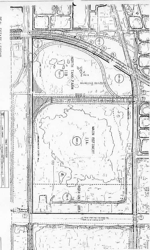
1 INDIANA HARBOR AND CANAL CONFINED DISPOSAL FACILITY EAST CHICAGO, INDIANA APPENDIX J REAL ESTATE Acquisition Branch Real Estate Division Chicago District U.S. Army Corps of Engineers
2 APPENDIX J REAL ESTATE PLAN TABLE OF CONTENTS ITEM PARAGRAPH PAGE INTRODUCTION...1 PURPOSE 1 1 DESCRIPTION OF LER SPONSOR OWNED LER 3 2 NONSTANDARD ESTATES. 4 2 EXISTING FEDERAL PROJECT FEDERALLY OWNED LAND NAVIGATIONAL SERVITUDE 7 3 PROJECT AREA AND MAPS 8 3 POSSIBLE INDUCED FLOODING BASELINE COST ESTIMATE RELOCATION ASSISTANCE BENEFITS (PL ) MINERAL/TIMBER ACTIVITY UTILITIES/FACILITIES TO BE RELOCATED SPONSOR CAPABILITY ZONING ORDINANCES ENACTED ACQUSITION SCHEDULE WITH MILESTONES.16 6 PRESENCE OF CONTAMINANTS OWNER ATTITUDES/ISSUES 18 7 SPONSOR-NOTIFIED RISK OF ADVANCED ACQUISITION 19 7 OTHER REAL ESTATE ISSUES EXHIBIT A: PROJECT AREA MAP EXHIBIT B: PROJECT SITE MAP EXHIBIT C: BASELINE COST ESTIMATE EXHIBIT D: FINAL ATTORNEY S OPINION OF COMPENSABILITY
3 INDIANA HARBOR AND CANAL CONFINED DISPOSAL FACILITY MAINTENANCE DREDGING AND DISPOSAL ACTIVITIES PURPOSE APPENDIX J REAL ESTATE INTRODUCTION This Real Estate supplement supports the Detailed Design Report for this project. 1. This Real Estate Appendix describes the overall real estate requirements for the Indiana Harbor Confined Disposal Facility. DESCRIPTION OF LANDS, EASEMENTS, AND RIGHTS-OF-WAY 2. IHC is located in East Chicago, Lake County, Indiana. It is on the Southwest shore of Lake Michigan, 4 ½ miles east of the Illinois-Indiana State Line and 17 miles from downtown Chicago (see map labeled Exhibit A). The site is located in an industrial area. The nearest housing development is over ½ mile from the site. Total land requirements for this project are acres. One area of concern is identifying an adequate borrow site for the project. A potential site has been identified but has not yet been confirmed as to adequacy. Preliminary estimates are that up to 1 million cubic yards of clay will be required for the project. The Real Estate Division has recently encountered problems in securing adequate borrow sites for other projects in the immediate area. The following estates may be acquired for this project: 1.FEE. The fee simple title to (the land described in Schedule A), subject, however, to existing easements for public roads and highways, public utilities, railroads, and pipelines. 2.TEMPORARY WORK AREA EASEMENT. A temporary easement and rightof-way in, on, over and across (the land described in Schedule A), for a period not to exceed, beginning with date possession of the land is granted to the United States, for use by the United States, its representatives, agents, and contractors as a (borrow area) (work area), including the right to (borrow and/or deposit fill, spill and waste material thereon), move, store and remove equipment and supplies and erect and remove temporary structures on the land and to perform any other work necessary and incident to Project, together with the right to trim, cut, fell and remove therefrom all trees, underbrush, obstructions, and any other vegetation, structures, or obstacles within the limits of the right-of-way; reserving, however, to the J-1
4 landowners, their heirs and assigns, all such rights and privileges as may be used without interfering with or abridging the rights and easement hereby acquired; subject, however, to existing easements for public roads and highways, public utilities, railroads and pipelines. 3.BORROW PIT AND SPOIL AREA EASEMENT AND RIGHT OF WAY. The temporary easement and right of way for a period not to exceed, in, over, and across (the land described in Schedule A ) (Tracts Nos., and ) for the purpose of removing borrow material and/or of depositing waste material thereon in connection with the construction, operation and maintenance of project; together with the right to trim, cut, fell and remove timber, underbrush and other vegetation, structures, and any other obstructions or obstacles; reserving, however, to the owners of the said land, their heirs, administrators, executors, successors, and assigns, all such rights and privileges as may be used and enjoyed without interfering with or abridging the rights and easements hereby acquired; the above estate is taken subject to existing easements for public roads and highways, public utilities, railroads and pipelines. SPONSOR OWNED LER 3. The Non-Federal Sponsor, the East Chicago Waterway Management District, currently owns on or near the project area. The total land area required for this project is acres, all of which is owned in fee by the Non-Federal Sponsor. This figure is comprised of acres for the CDF itself, as well as acres to be used as a Rehandling and Treatment area. NONSTANDARD ESTATES 4. No non-standard estates are contemplated for this project. EXISTING FEDERAL PROJECT 5. The existing Federal navigation project at the IHC was authorized by the River and Harbor Acts of 1910, and subsequent Acts of 1913, 1919, 1922, 1925, 1930, 1932, 1935, 1937, 1960, and The existing project is now complete except for maintenance dredging. The project consisted of the construction of three breakwaters, one lighthouse crib, and various dredging activities, all of which can be found on pg. 5 of the Design Documentation Report. FEDERALLY OWNED LAND 6. No Federally owned lands are invoked in this project. J-2
5 NAVIGATIONAL SERVITUDE 7. As mentioned in paragraph two, navigational servitude will be invoked for the maintenance dredging portions of this project. PROJECT AREA AND MAPS 8. The proposed ECI confined disposal facility is located on lands that have open RCRA status. Approximately the south 400 feet of the ECI site (also known as Parcel I) previously housed the RCRA hazardous waste units. These structures were razed along with the above ground structures, but were never closed in conformance with RCRA regulations. Indiana Department of Environmental Management (IDEM) must approve proposals for closure of the RCRA hazardous waste units in the State of Indiana. Due to the ubiquitous nature of the on-site contamination on this parcel, IDEM determined that closure in place would be most appropriate for the area that previously housed these hazardous waste units. The in-site closure design of Parcel I would include a slurry wall, a gradient control system consisting of groundwater extraction wells that would maintain groundwater flow into this portion of the CDF, and an overlaying three foot compacted clay cap. The U.S. EPA has determined that construction of these components would address the corrective action requirements for Parcel I as well as Parcels IIA and IIB. These RCRA closure and corrective action components have been incorporated into the proposed CDF design. (See map labeled Exhibit B.) POSSIBLE INDUCED FLOODING 9. No induced flooding is being considered for this project. BASELINE COST ESTIMATE 10. The proposed site was formerly owned by Energy Cooperative, Inc. (ECI). This site was a former oil refinery that was demolished in the 1980 s. The refinery operations included the production of mineral spirits, propane, unleaded gasoline, fuel oil, kerosene, asphalt, grease, lubricating oils, paraffin wax, phenols, and sulfur. Additional investigation in 1990, including discussions with U.S. EPA, and the State of Indiana, indicated that the oil refinery structures on the site had been removed above the ground surface. However, there were facilities below ground level that had not yet been removed, including two structures that come under regulatory authority of RCRA. A gross appraisal has been completed on the site that concluded that as clean industrial land it would have a value of $331,000. The site currently has an open RCRA status and is not available for use until corrective action and closure meeting IDEM and U.S. EPA standards has been completed. The cost of corrective action, or cost to cure, J-3
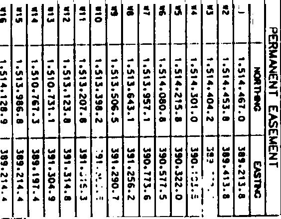
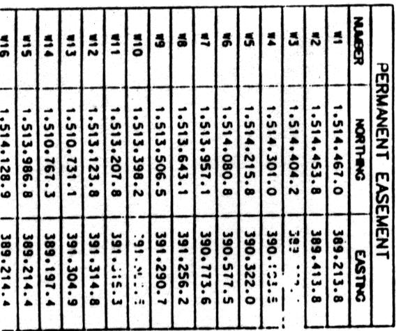
6 was estimated by Chicago District to exceed $25,000,000, resulting in negative land value. The U.S. EPA has determined that cleanup is not economically viable. The land is therefore valued at $0. Administrative costs have been estimated for typical review of the non-federal Sponsor. However, certain tasks will be performed by the Real Estate division on behalf of the Sponsor. As a result, the cost to review such tasks will be significantly lower. At this time, no assumptions can be made as to the cost of utility/facility relocations. One area of concern is the identification of an adequate borrow site for the project. Preliminary estimates are that up to 1 million cubic yards of clay will be required for project purposes. The Real Estate Division has recently found that adequate clay borrow sites for other projects in the area of this project have been difficult to develop within a reasonable distance. Since no definitive borrow site has been identified, an allowance for borrow costs was estimated. Approximately the same number of CY of clay was extracted from the Deep River Borrow Site. It was used as a baseline for estimating borrow site costs for this project. The easement cost for Deep River was $86,000 for a five-year easement commencing in The CDF will not be capped until 33 years into the project, approximately Using an inflation factor of 2.5% per year, and a contingency factor of 35%, as more than one borrow site may be needed to extract the required amount of clay, the borrow site cost was estimated to be $344,250. (See Exhibit C.) RELOCATION ASSISTANCE BENEFITS (PL ) 11. No Public Law relocations are required for this project. MINERAL/TIMBER ACTIVITY 12. There are no mineral extraction activities operating on or near the project lands at this time. Furthermore, no extractable minerals are known to exist within the project lands. No standing timber or vegetative cover having significant value has been identified. UTILITIES/FACILITIES TO BE RELOCATED 13. A 6.55-acre railroad easement bisecting the site will require relocation in kind to the northern boundary of the site. The relocation area totals 3.44 acres (see map labeled Exhibit B). Preliminary negotiations with the railroad, CSX, indicate legal problems exist between themselves and the State of Indiana regarding railroad rights-of-way. They suggested a friendly condemnation as the quickest way to resolve this problem. The non-federal Sponsor is expected to request that the Corps of Engineers conduct the condemnation proceedings on their behalf and understands that this is a local responsibility. However, the Sponsor has no condemnation powers. They intend to enter into a Memorandum of Agreement with the Government, and fund all activities associated with this condemnation in advance. A formal request is forthcoming and a J-4
7 Draft MOA has been prepared. Conversations with CSX indicate that the rail spur is active, supporting several steel mills and an Amoco refinery, and that they have no intention of abandoning the line. A preliminary relocation plan has been reviewed and approved by CSX. An Attorney Opinion of Compensability to determine the interest of the railroad is included (see Exhibit D). Previous reports have identified other utilities in the project area. Inasmuch as the entire ECI facility has been demolished, all utilities related to operation are assumed to be inactive. If live utilities are discovered as a result of the inspection trench exploration, costs will be adjusted at that time. Provisions will be made in the MOA to include this work if needed. SPONSOR CAPABILITY 14. The non-federal Sponsor for this district is the East Chicago Waterway Management District. This is an established waterway management district pursuant to Indiana Statutes, Title 8, Article 10, Chapter 9. The district s jurisdiction includes all territory, including both dry land and water, within a distance of one-half (1/2) mile on either side of the center line of any waterway within the city in which the district is established as stated in the above-mentioned Indiana Statute. According to the same Indiana Statute, one purpose of the district is to plan for, develop, and maintain roads, bridges, and other structures in connection with a waterway within the jurisdiction of the district consistent with the obligations and jurisdictions of other agencies of the federal or state government. Because only minimal acquisition is required for this project and the non-federal Sponsor will seek Federal assistance in the railroad relocation, the Real Estate Acquisition Capabilities Assessment was abbreviated to address only the pertinent questions. I. Legal Authority a. Does the Sponsor have legal authority to acquire and hold title to real property for project purposes? Yes b. Does the Sponsor have power of eminent domain for the project? No c. Does the Sponsor have quick take authority for this project? No d. Are any of the lands/interests in land required for the project located outside of the Sponsor s political boundary? No e. Are any of the lands/interests required for the project owned by an entity whose property the Sponsor cannot condemn? Condemnation of the CSX railroad right-of-way for relocation will be handled by J-5
8 USACE on behalf of the non-federal Sponsor, as will any unidentified utility relocation. f. Will the Sponsor likely request USACE assistance in acquiring real estate? Yes, the Sponsor has no condemnation powers under its statutory authorities and, unless subsequently obtained, will request that the Federal government perform a friendly condemnation suggested by the railroad. The non-federal Sponsor already owns all CDF lands in fee, including lands to be provided for the railroad relocation. g. Will the Sponsor s staff be located within reasonable proximity to the project site? Yes h. Has the Sponsor approved the project/real estate schedule/milestones? Yes i. With regard to this project, the Sponsor is anticipated to be: Fully capable II. Coordination a. Has this assessment been coordinated with the Sponsor? Yes b. Does the Sponsor concur with this assessment? Yes ZONING ORDINANCES ENACTED 15. Lands for this project are currently zoned industrial. ACQUISITION SCHEDULE WITH MILESTONES 16. All lands required for this project are owned by the non-federal Sponsor. The current engineering decision to require contractors to obtain their own borrow material and include that cost in their contract bids may be changed. Such a change would require that a borrow easement be obtained. Rights-of-Entry and Attorney Certifications should be completed in May 2000, within one month of the signing of the Project Cooperation Agreement. Railroad relocation should be completed by May 2001, through condemnation. Development of borrow sites will be accomplished within 1 year of identification. J-6
9 PRESENCE OF CONTAMINANTS 17. Appendix R contains an analysis of HTRW materials located at the site, now owned in fee by the non-federal Sponsor. The previous owner, and Potentially Responsible Party, is ECI. ECI declared Chapter 7 bankruptcy and is no longer in existence. Proceeds from the bankruptcy totaling $13.22 million were set aside for closure and corrective action in a trust fund which is controlled by the non-federal Sponsor as trustee. ARCO, a previous owner, has participated in corrective action to a limited extent. A risk analysis, found in pages of the Final Feasibility Report, was performed concerning the construction of the CDF. Given the design of the CDF, CERCLA exposures for releases are not likely. USACE will be operating the CDF until capped, and will participate in monitoring after the CDF is capped. OWNER ATTITUDES/ISSUES 18. The non-federal Sponsor is most anxious to initiate this project since no dredging activity has been conducted in the harbor since The sediment accumulation prevents ships from carrying full loads in the harbor and canal, thus creating an adverse economic impact to deep-draft navigation. Industry in the area is in favor of this project due to the economic benefits of increased navigation capabilities allowed by the dredging portion of the project. Local residents have concerns relating to dredge material odor and fear of contaminant migration from the CDF site. SPONSOR NOTIFIED RISK OF ADVANCED ACQUISITION 19. The non-federal Sponsor has been notified that any acquisition that occurs before signing the PCA will be at its own expense. OTHER REAL ESTATE ISSUES 20. There are no other real estate issues at this time. J-7
10


11


12


13

14


15


16
JANUARY 2016 MAMARONECK & SHELDRAKE RIVERS NEW YORK FLOOD RISK MANAGEMENT GENERAL REEVALUATION REPORT FOR THE VILLAGE OF MAMARONECK APPENDIX E
 U.S. Army Corps of Engineers New York District MAMARONECK & SHELDRAKE RIVERS NEW YORK FLOOD RISK MANAGEMENT GENERAL REEVALUATION REPORT FOR THE VILLAGE OF MAMARONECK JANUARY 2016 APPENDIX E REAL ESTATE
Appendix B Real Estate Plan
 Appendix B Real Estate Plan B-1 REAL ESTATE PLAN Prepared for U.S. Army Corps of Engineers Southwestern Division Little Rock District As of May 1, 2013 Prepared by Ronald Bridges Real Estate Division ANY
Appendix B Draft Real Estate Plan
 Appendix B Draft Real Estate Plan B-1 REAL ESTATE PLAN Prepared for U.S. Army Corps of Engineers Southwestern Division Little Rock District As of December 3, 2012 Prepared by Ronald Bridges Real Estate
Appendix G. Non-Federal Letters of Support and Draft Real Estate Plan
 Appendix G Non-Federal Letters of Support and Draft Real Estate Plan REAL ESTATE PLAN UPPER DELAWARE RIVER WATERSHED FEASABILITY STUDY LIVINGSTON MANOR, NEW YORK 1. GENERAL 2. REAL ESTATE REQUIREMENTS
DRAFT INTEGRATED FEASIBILITY REPORT AND ENVIRONMENTAL ASSESSMENT
 APPENDIX E REAL ESTATE PLAN MT. SINAI MEDICAL CENTER, CONTINUTING AUTHORITIES PROGRAM (CAP) SECTION 14, PROJECT DRAFT INTEGRATED FEASIBILITY REPORT AND ENVIRONMENTAL ASSESSMENT September 2016 DRAFT APPENDIX
Appendix C. Real Estate. Brazos Island Harbor, Texas Channel Improvement Project Cameron County, Texas
 Appendix C Real Estate Brazos Island Harbor, Texas Channel Improvement Project Cameron County, Texas U.S. Army Corps of Engineers, Galveston District 2000 Fort Point Road Galveston, Texas 77550 December
Draft Continuing Authorities Program Section 1135 Detailed Project Report and Integrated Environmental Assessment
 Appendix G Real Estate Shorty s Island / Meander Reach Ecosystem Restoration Kootenai River, Idaho Draft Continuing Authorities Program Section 1135 Detailed Project Report and Integrated Environmental
Delaware River Basin Comprehensive Flood Risk Management Interim Feasibility Study and Integrated Environmental Assessment for New Jersey
 Delaware River Basin Comprehensive Flood Risk Management Interim Feasibility Study and Integrated Environmental Assessment for New Jersey Flooding in the Study Area, April 2005 June 2015 APPENDIX F: Draft
EDISTO BEACH COASTAL STORM DAMAGE REDUCTION GENERAL INVESTIGATION STUDY APPENDIX K REAL ESTATE
 EDISTO BEACH COASTAL STORM DAMAGE REDUCTION GENERAL INVESTIGATION STUDY APPENDIX K REAL ESTATE Table of Contents REAL ESTATE APPENDIX... I... i SECTION 1. THE REAL ESTATE REPORT... 1 1.1 Statement of Purpose...
APPENDIX M. Real Estate Plan
 APPENDIX M Real Estate Plan Poplar Island Environmental Restoration Project September 2005 General Reevaluation Report (GRR) and Supplemental Environmental Impact Statement (SEIS) REAL ESTATE PLAN (REP)
MAMARONECK AND SHELDRAKE RIVER FLOOD DAMAGE REDUCTION PROJECT MAMARONECK, NEW YORK APPENDIX E REAL ESTATE PLAN
 U.S. Army Corps of Engineers New York District MAMARONECK AND SHELDRAKE RIVER FLOOD DAMAGE REDUCTION PROJECT MAMARONECK, NEW YORK APPENDIX E REAL ESTATE PLAN April 2017 MAMARONECK AND SHELDRAKE RIVER FLOOD
APPENDIX F REAL ESTATE
 APPENDIX F REAL ESTATE Real Estate Plan For Broward County, Florida Shore Protection Project Segments II and III General Reevaluation Report 1. Statement Of Purpose. The Real Estate Plan is tentative in
APPENDIX D - REAL ESTATE
 APPENDIX D - REAL ESTATE 1. Purpose Real Estate Plan For Feasibility Study For Lake Lou Yaeger Section 206 Aquatic Ecosystem Restoration Continuing Authorities Project Feasibility Study This report is
WEST SHORE LAKE PONTCHARTRAIN HURRICANE AND STORM DAMAGE RISK REDUCTION STUDY INTEGRATED DRAFT FEASIBILITY REPORT AND ENVIRONMENTAL IMPACT STATEMENT
 WEST SHORE LAKE PONTCHARTRAIN HURRICANE AND STORM DAMAGE RISK REDUCTION STUDY INTEGRATED DRAFT FEASIBILITY REPORT AND ENVIRONMENTAL IMPACT STATEMENT REAL ESTATE PLAN APPENDIX C Annex A: Project Maps Annex
Draft Integrated Feasibility Report and Environmental Assessment and Draft Finding of No Significant Impact
 Draft Integrated Feasibility Report and Environmental Assessment and Draft Finding of No Significant Impact APPENDIX F: REAL ESTATE Whittier, Alaska June 2018 Pacific Ocean Division DRAFT REAL ESTATE
APPENDIX G REAL ESTATE
 BUBBLY CREEK, SOUTH BRANCH OF THE CHICAGO RIVER, ILLINOIS FEASIBILITY STUDY APPENDIX G REAL ESTATE DRAFT - NOT FOR DISTRIBUTION APRIL 2015 U.S. Army Corps of Engineers Chicago District Appendix G Real
Draft Appendix E. Real Estate Plan. Rahway River Basin, New Jersey Flood Risk Management Feasibility Study. November 2016
 Draft Appendix E Real Estate Plan Rahway River Basin, New Jersey Flood Risk Management Feasibility Study November 2016 New Jersey Department of Environmental Protection U.S. Army Corps of Engineers New
HASHAMOMUCK COVE, SOUTHOLD, NEW YORK COASTAL STORM RISK MANAGEMENT FEASIBILITY STUDY APPENDIX F REAL ESTATE PLAN
 U.S. Army Corps of Engineers New York District HASHAMOMUCK COVE, SOUTHOLD, NEW YORK COASTAL STORM RISK MANAGEMENT FEASIBILITY STUDY APPENDIX F REAL ESTATE PLAN AUGUST 2016 HASHAMOMUCK COVE, SOUTHOLD, NEW
Appendix K. Real Estate Plan
 Appendix K. Real Estate Plan REAL ESTATE PLAN DELTA ISLANDS AND LEVEES FEASIBILITY STUDY (DELTA STUDY) 20 June 2018 PREPARED BY THE SACRAMENTO DISTRICT U.S. ARMY CORPS OF ENGINEERS 1 TABLE OF CONTENTS
REAL ESTATE PLAN APPENDIX G
 Pacific Ocean Division REAL ESTATE PLAN APPENDIX G Alaska District UNALASKA (DUTCH HARBOR) CHANNELS UNALASKA, ALASKA Real Estate Division Alaska District U.S. Army Corps of Engineers TABLE OF CONTENTS
AGREEMENT TO ACQUIRE LANDS BETWEEN THE DEPARTMENT OF THE ARMY ST. PAUL DISTRICT, CORPS OF ENGINEERS AND. THE CITY OF City, State
 AGREEMENT TO ACQUIRE LANDS BETWEEN THE DEPARTMENT OF THE ARMY ST. PAUL DISTRICT, CORPS OF ENGINEERS AND THE CITY OF City, State FOR CONDEMNATION ON BEHALF OF THE SPONSOR BY THE CORPS OF ENGINEERS FOR THE
Final General Reevaluation Report and Final Environmental Impact Statement. Hurricane Protection and Beach Erosion Control
 Final General Reevaluation Report and Final Environmental Impact Statement on Hurricane Protection and Beach Erosion Control WEST ONSLOW BEACH AND NEW RIVER INLET (TOPSAIL BEACH), NORTH CAROLINA Appendix
APPENDIX E REAL ESTATE PLAN
 APPENDIX E REAL ESTATE PLAN REAL ESTATE PLAN VILLAGE OF BARBOURSVILLE, WATER STREET, STREAMBANK PROTECTION PROJECT CABELL COUNTY, WEST VIRGINIA SECTION 14 1. Authority/Purpose This Real Estate Plan is
Appendix H: Real Estate Plan
 APPENDIX H Spring Creek North Ecosystem Restoration Feasibility Study Appendix H: Real Estate Plan New York District U.S. Army Corps of Engineers October 2016 Revised: 13 April 2017 Spring Creek North
DRAFT REAL ESTATE PLAN APPENDIX D JEFFERSON COUNTY ECOSYSTEM RESTORATION FEASIBILITY STUDY
 DRAFT REAL ESTATE PLAN APPENDIX D JEFFERSON COUNTY ECOSYSTEM RESTORATION FEASIBILITY STUDY (NOTE: This page intentionally left blank.) This Real Estate Plan has been prepared in accordance with ER 405-1-12
Draft Environmental Impact Statement (EIS)/Environmental Impact Report (EIR) APPENDIX H Real Estate Cost
/Environmental Impact Report (EIR) APPENDIX H Real Estate Cost") Draft Environmental Impact Statement (EIS)/Environmental Impact Report (EIR) APPENDIX H Real Estate Cost US Army Corps of Engineers Corte Madera Creek Flood Risk Management Project October 2018 APPENDIX
Draft Environmental Impact Statement (EIS)/Environmental Impact Report (EIR) APPENDIX H Real Estate Cost US Army Corps of Engineers Corte Madera Creek Flood Risk Management Project October 2018 APPENDIX
Appendix J. Real Estate Plan
 Appendix J Real Estate Plan Real Estate Plan Louisiana Coastal Area Near-Term Ecosystem Restoration Plan Medium Diversion at White Ditch 1. PURPOSE Title VII of the Water Resources Development Act of 2007
DRAFT East Rockaway Inlet to Rockaway Inlet and Jamaica Bay. Atlantic Coast of New York
 DRAFT East Rockaway Inlet to Rockaway Inlet and Jamaica Bay Atlantic Coast of New York APPENDIX E REAL ESTATE PLAN AUGUST 2018 East Rockaway Inlet to Rockaway Inlet and Jamaica Bay Reformulation Study
Appendix D Real Estate Plan
 Appendix D Real Estate Plan Matagorda Ship Channel, Port Lavaca, Texas Feasibility Report and Environmental Impact Statement, Review of Completed Projects, Calhoun and Matagorda Counties May 2018 (NOTE:
APPENDIX H. Real Estate Plan
 INTEGRATED FEASIBILITY REPORT AND ENVIRONMENTAL IMPACT STATEMENT COASTAL STORM DAMAGE REDUCTION BOGUE BANKS, CARTERET COUNTY NORTH CAROLINA APPENDIX H Real Estate Plan US Army Corps of Engineers Wilmington
Skagit River Flood Risk Management General Investigation Skagit County, Washington. Draft Feasibility Report and Environmental Impact Statement
 General Investigation Skagit County, Washington Draft Feasibility Report and Environmental Impact Statement May 2014 Real Estate Requirements of Selected Plan This Real Estate Plan Summary (REP) is presented
APPENDIX H REAL ESTATE REQUIREMENTS
 Malden River Ecosystem Restoration Detailed Project Report APPENDIX H REAL ESTATE REQUIREMENTS April 2007 Malden River Ecosystem Restoration Real Estate Report 1. PURPOSE: The Detailed Project Report
APPENDIX C REAL ESTATE PLAN BOULEVARD RESACA, BROWNSVILLE, TX CAMERON COUNTY, TEXAS
 APPENDIX C REAL ESTATE PLAN BOULEVARD RESACA, BROWNSVILLE, TX CAMERON COUNTY, TEXAS November 19, 2016 Table of Contents Purpose... 3 Project Authority... 3 Project Location and Description... 3 Non-Federal
Ch. 253 ENVIRONMENTAL COVENANTS ACT CHAPTER 253. ADMINISTRATION OF THE UNIFORM ENVIRONMENTAL COVENANTS ACT
 Ch. 253 ENVIRONMENTAL COVENANTS ACT 25 253.1 CHAPTER 253. ADMINISTRATION OF THE UNIFORM ENVIRONMENTAL COVENANTS ACT Sec. 253.1. Definitions. 253.2. Contents and form of environmental covenant. 253.3. Notice
Appendix D: Real Estate
 Shrewsbury River Basin, Sea Bright, New Jersey Coastal Storm Risk Management Feasibility Study Draft Integrated Feasibility Report & Environmental Assessment Appendix D: Real Estate Shrewsbury River Basin,
Dredged Material Management Plan Atlantic Intracoastal Waterway Port Royal Sound, South Carolina to Cumberland Sound, Georgia November 2015
 Dredged Material Management Plan Atlantic Intracoastal Waterway Port Royal Sound, South Carolina to Cumberland Sound, Georgia November 2015 Appendix H: Real Estate US Army Corps of Engineers South Atlantic
Downtown Montauk Stabilization Project. Real Estate Plan Appendix
 Downtown Montauk Stabilization Project Real Estate Plan Appendix October 2014 Table of Contents Page 1. Introduction and General Information 1 a. Authority 2 b. History 2 c. Location Project Study Area
UPPER MISSISSIPPI RIVER RESTORATION FEASIBILITY REPORT WITH INTEGRATED ENVIRONMENTAL ASSESSMENT
 UPPER MISSISSIPPI RIVER RESTORATION FEASIBILITY REPORT WITH INTEGRATED ENVIRONMENTAL ASSESSMENT McGregor Lake HABITAT REHABILITATION AND ENHANCEMENT PROJECT POOL 10, UPPER MISSISSIPPI RIVER MILE 635-634
REAL ESTATE PLAN. Final Integrated General Reevaluation Report and Supplemental Environmental Impact Statement
 REAL ESTATE PLAN Final Integrated General Reevaluation Report and Supplemental Environmental Impact Statement Mississippi River, Baton Rouge to the Gulf of Mexico Mississippi River-Gulf Outlet, Louisiana,
BEACH STORM DAMAGE REDUCTION EASEMENT
 STATE OF FLORIDA COUNTY OF WALTON WALTON COUNTY, FL HURRICANE & STORM DAMAGE REDUCTION PROJECT FILE/REACH#: PARCEL ID#: BEACH STORM DAMAGE REDUCTION EASEMENT KNOW ALL MEN BY THESE PRESENTS, that for and
DRAFT REAL ESTATE PLAN APPENDIX C GULF INTRACOASTAL WATERWAY BRAZOS RIVER FLOODGATES AND COLORADO RIVER LOCKS SYSTEMS FEASIBILITY STUDY
 DRAFT REAL ESTATE PLAN APPENDIX C GULF INTRACOASTAL WATERWAY BRAZOS RIVER FLOODGATES AND COLORADO RIVER LOCKS SYSTEMS FEASIBILITY STUDY This Real Estate Plan has been prepared in accordance with ER 405-1-12
HUNTING BAYOU FLOOD RISK MANAGEMENT, HARRIS COUNTY, TEXAS DRAFT GENERAL REEVALUATION REPORT AND INTEGRATED ENVIRONMENTAL ASSESSMENT
 HUNTING BAYOU FLOOD RISK MANAGEMENT, HARRIS COUNTY, TEXAS DRAFT GENERAL REEVALUATION REPORT AND INTEGRATED ENVIRONMENTAL ASSESSMENT APPENDIX 6 REAL ESTATE PLAN June 2014 HARRIS COUNTY FLOOD CONTROL DISTRICT
Environmental Management Chapter
 Environmental Management Chapter 335-5-1 ALABAMA DEPARTMENT OF ENVIRONMENTAL MANAGEMENT LAND DIVISIONS - UNIFORM ENVIRONMENTAL COVENANTS PROGRAM ADMINISTRATIVE CODE CHAPTER 335-5-1 GENERAL TABLE OF CONTENTS
CENAN-RE 22 May MEMORANDUM FOR Chief, Planning Division, ATTN: CENAN-PL-F (Alek Petersen)
") CENAN-RE 22 May 2017 MEMORANDUM FOR Chief, Planning Division, ATTN: CENAN-PL-F (Alek Petersen) SUBJECT: May 2017 Real Estate Plan for the Rahway River (Tidal) Basin, Coastal Storm Risk Management Feasibility
CENAN-RE 22 May 2017 MEMORANDUM FOR Chief, Planning Division, ATTN: CENAN-PL-F (Alek Petersen) SUBJECT: May 2017 Real Estate Plan for the Rahway River (Tidal) Basin, Coastal Storm Risk Management Feasibility
Southwest Coastal Louisiana Study
 REAL ESTATE PLAN Annex 1: Project Maps Annex 2: Assessment of Non-Federal Sponsor s Acquisition Capability Annex 3: Non-Material Deviation from Standard Estate Perpetual Access Easement Annex 4: Baseline
Minnesota Pollution Control Agency Voluntary Investigation and Cleanup
 Minnesota Pollution Control Agency Voluntary Investigation and Cleanup Summary of Applicable Laws 1.0 Introduction Guidance Document #3 Over the past few years, the Minnesota Superfund law, known as the
DWR REAL ESTATE COORDINATION PLAN
 DWR REAL ESTATE COORDINATION PLAN Exhibit E DWR PROPERTY ACQUISTION PLAN EXHIBIT E Revised Date: 5 10 18 DWR PROPERTY ACQUISTION PLAN EXHIBIT E Revised Date: 5-10-2018 California WaterFix Real Estate Coordination
State Revolving Fund Loan Programs Guidance for Project Land Acquisition For SRF Financed Projects
 Revised November 30, 2006 State Revolving Fund Loan Programs Guidance for Project Land Acquisition For SRF Financed Projects I. Introduction: If an SRF financed project requires access to or acquisition
DEPARTMENT OF THE ARMY U.S. Army Corps of Engineers Washington, DC Regulation No May 2015
 CEMP-CR DEPARTMENT OF THE ARMY U.S. Army Corps of Engineers Washington, DC 20314-1000 ER 405-1-19 Regulation No. 405-1-19 29 May 2015 Real Estate ACQUISITION BY CONDEMNATION PROCEEDINGS 1. Purpose. Engineer
ALABAMA DEPARTMENT OF ENVIRONMENTAL MANAGEMENT LAND DIVISION - UNIFORM ENVIRONMENTAL COVENANTS PROGRAM DIVISION 335-5
 ALABAMA DEPARTMENT OF ENVIRONMENTAL MANAGEMENT LAND DIVISION - UNIFORM ENVIRONMENTAL COVENANTS PROGRAM DIVISION 335-5 1400 Coliseum Blvd. Montgomery, Alabama 36110 CITE AS ADEM Admin. Code r. 335-5-x-.xx
Senate Eminent Domain Bill SF 2750 As passed by the Senate. House Eminent Domain Bill HF 2846/SF 2750* As passed by the House.
 Scope Preemption. Provides that Minn. Stat. Chapter 117 preempts all other laws, including special laws, home rule charters, and other statutes, that provide eminent domain powers. Public service corporation
TOWNSHIP OF SCIO MORATORIUM RESOLUTION REGARDING OIL AND GAS OPERATIONS IN TOWNSHIP
 TOWNSHIP OF SCIO MORATORIUM RESOLUTION REGARDING OIL AND GAS OPERATIONS IN TOWNSHIP At a special meeting of the Township Board of the Township of Scio held at the Township Hall, August 20, 2014. WHEREAS,
For Sale SEALED BID SALE. Sale No. GSA-R Former Missile Launch Facilities Whiteman AFB, Missouri
 For Sale SEALED BID SALE Sale No. 7 Former Missile Launch Facilities Whiteman AFB, Missouri Located in Bates, Johnson, Pettis and Saline Counties, Missouri BID OPENING August 16, 2005 U.S. General Services
GENERAL RE-EVALUATION REPORT APPENDIX B: REAL ESTATE SAVANNAH HARBOR EXPANSION PROJECT Chatham County, Georgia and Jasper County, South Carolina
 GENERAL RE-EVALUATION REPORT APPENDIX B: REAL ESTATE SAVANNAH HARBOR EXPANSION PROJECT Chatham County, Georgia and Jasper County, South Carolina January 2012 (Revised July 2012) US Army Corps of Engineers
City of East Providence
 City of East Providence 145 TAUNTON AVENUE, EAST PROVIDENCE STATE OF RHODE ISLAND AND PROVIDENCE PLANTATIONS 02914-4505 TEL. (401) 435-7521 FAX (401) 438-1719 TDD (401) 431-1633 CITY MANAGER PETER GRACZYKOWSKI
Submittal of the Minutes from the March 9, 2011, April 5, 2011, and April 19, 2011 Cabinet Meetings.
 AGENDA BOARD OF TRUSTEES OF THE INTERNAL IMPROVEMENT TRUST FUND JUNE 16, 2011 Attachments to the items below can be viewed at the following link: http://www.dep.state.fl.us/secretary/cab/public_notices.htm
APPENDIX F REAL ESTATE PLAN. Redwood City Harbor Navigation Improvement Feasibility Study, Redwood City, California
 APPENDIX F REAL ESTATE PLAN Redwood City Harbor Navigation Improvement Feasibility Study, Redwood City, California PREPARED FOR THE SAN FRANCISCO DISTRICT SOUTH PACIFIC DIVISION 20 April 2015 PREPARED
Technical Information Paper No
 Environmental Condition of Property (ECOP) Investigations Technical Information Paper No. 38-001-0312 PURPOSE. To provide information on ECOP investigations for Federal real property transactions and military
Attached is a Clinton Township Zoning Permit Application and requirements for issuance of a permit.
 To Whom It May Concern: Attached is a Clinton Township Zoning Permit Application and requirements for issuance of a permit. The fee for the permit application is $75.00, which shall be made payable to
Bill of Rights. Cities of 5,000 or more population; adoption or amendment of charter
 CITATION TITLE HEADINGS TEXT Tex. Const. art. I, 17 Taking, Damaging, or Destroying Property for Public Use; Special Privileges and Immunities; Control of Privileges and Franchises. Bill of Rights (a)
Mississippi River Ship Channel Gulf to Baton Rouge, LA Integrated General Reevaluation Report And Supplemental Environmental Impact Statement
 APPENDIX B Real Estate Plan B-1.0 PROJECT PURPOSE, DESCRIPTION, LOCATION AND DESCRIPTION OF THE LANDS, EASEMENTS, RIGHTS-OF-WAY, RELOCATIONS AND DISPOSAL (LERRD) REQUIRED The purpose of this Real Estate
Preparing for Negotiations: The Environmental Lawyer s Checklist In Oil and Gas Transactions
 Preparing for Negotiations: The Environmental Lawyer s Checklist In Oil and Gas Transactions Presented by Jim Morriss Thompson & Knight LLP james.morriss@tklaw.com The Process Drives the Checklist Confidentiality
NC General Statutes - Chapter 153A Article 15 1
 Article 15. Public Enterprises. Part 1. General Provisions. 153A-274. Public enterprise defined. As used in this Article, "public enterprise" includes: (1) Water supply and distribution systems. (2) Wastewater
UPPER MISSISSIPPI RIVER RESTORATION FEASIBILITY REPORT WITH INTEGRATED ENVIRONMENTAL ASSESSMENT
 UPPER MISSISSIPPI RIVER RESTORATION FEASIBILITY REPORT WITH INTEGRATED ENVIRONMENTAL ASSESSMENT BEAVER ISLAND HABITAT REHABILITATION AND ENHANCEMENT PROJECT POOL 14, UPPER MISSISSIPPI RIVER MILES 513.0-517.0
PRIVATE PROPERTY PUBLIC PURPOSE
 PRIVATE PROPERTY PUBLIC PURPOSE Understanding Right-of-Way Acquisition for Transmission Lines At Progress Energy, we are committed to providing safe, reliable and affordable energy to our customers. As
QUESTIONS IN REGARDS TO THE MASTER LEASE RFP
 QUESTIONS IN REGARDS TO THE MASTER LEASE RFP 1. Based on the reduction in liabilities by 60% and annual sales growth of 10%, under your current leadership and oversight by the Board, has IIPD established
APPENDIX D REAL ESTATE PLAN
 APPENDIX D REAL ESTATE PLAN APPENDIX D REAL ESTATE PLAN TABLE OF CONTENTS 1. STATEMENT OF PURPOSE 2. REFERENCES 3. AUTHORIZATION 4. BACKGROUND 5. LOCATION 6. REAL ESTATE REQUIREMENTS 7. OWNERSHIP OF REAL
Hazardous Materials in Project Development Additional Guidance
 Hazardous Materials in Project Development Additional Guidance Contents:...2 AASHTO Guidance...3 USDOT Brownfields Guidance...4 ASTM Standard Practices...6 Hazardous Materials in Project Development 1
IC Chapter 7. Real Property Transactions
 IC 8-23-7 Chapter 7. Real Property Transactions IC 8-23-7-0.1 Application of certain amendments to chapter Sec. 0.1. The amendments made to section 19 of this chapter by P.L.133-2007 apply only to public
The University of Texas System Systemwide Policy. Policy: UTS Title. Environmental Review for Acquisition of Real Property. 2.
 1. Title 2. Policy Environmental Review for Acquisition of Real Property Sec. 1 Sec. 2 Policy Statement. It is the policy of The University of Texas System to minimize its potential for exposure to claims
APPENDIX H REAL ESTATE PLAN
 APPENDIX H REAL ESTATE PLAN This page intentionally left blank. APPENDIX H REAL ESTATE PLAN DALLAS FLOODWAY FEASIBILITY STUDY DATE OF REPORT January 31, 2014 PREPARED BY REAL ESTATE DIVISION U.S. ARMY
BROWNFIELDS Connecticut All Grantee Meeting July Getting the most out of All Appropriate Inquiries (AAI)
") BROWNFIELDS Connecticut All Grantee Meeting July 11 2012 Getting the most out of All Appropriate Inquiries (AAI) 1 AAI in Perspective All Appropriate Inquiries often is a critical step in a continuum of
BROWNFIELDS Connecticut All Grantee Meeting July 11 2012 Getting the most out of All Appropriate Inquiries (AAI) 1 AAI in Perspective All Appropriate Inquiries often is a critical step in a continuum of
Appendix C REAL ESTATE PLAN
 Appendix C RAL STAT PLAN Section 203 Integrated Feasibility Report and Draft nvironmental Impact Statement RAL STAT PLAN HOUMA NAVIGATION CANAL CHANNL DPNING MIL 36.3 TO MIL 3.7 TRRBONN PARISH, LOUISIANA
Land Management Plan Fargo-Moorhead (FM) Area Flood Risk Reduction Project Version 1
 Area Flood Risk Reduction Project Version 1") Land Management Plan Fargo-Moorhead (FM) Area Flood Risk Reduction Project Version 1 Prepared for Fargo-Moorhead Area Flood Diversion Board of Authority July 12, 2012 REV 1 Contents Section Page Acronyms
Land Management Plan Fargo-Moorhead (FM) Area Flood Risk Reduction Project Version 1 Prepared for Fargo-Moorhead Area Flood Diversion Board of Authority July 12, 2012 REV 1 Contents Section Page Acronyms
Municipality of Anchorage PURCHASE AND SALE AGREEMENT FOR HLB Parcel C in Chugiak, Alaska
 Municipality of Anchorage PURCHASE AND SALE AGREEMENT FOR HLB Parcel 1-007-C in Chugiak, Alaska THIS AGREEMENT dated, 2017, by and between the MUNICIPALITY OF ANCHORAGE, an Alaska municipal corporation,
Anatomy Of An Appraisal
 Anatomy Of An Appraisal Leslie A. Fields The most important thing to know about an appraisal report is how to review and critique it. Leslie A. Fields a partner with the Law Firm of Faegre & Benson LLP,
GUIDANCE FOR LEAD-BASED PAINT HAZARD MANAGEMENT DURING TRANSFER OF ARMY REAL PROPERTY
 GUIDANCE FOR LEAD-BASED PAINT HAZARD MANAGEMENT DURING TRANSFER OF ARMY REAL PROPERTY DAIM-FDF-FE 30 March 2000 1. Purpose. The purpose of this guidance is to: a. Inform commanders of Army Major Commands
FIRE ISLAND INLET TO MORICHES INLET FIRE ISLAND STABILIZATION PROJECT TECHNICAL SUPPORT DOCUMENT
 FIRE ISLAND INLET TO MORICHES INLET FIRE ISLAND STABILIZATION PROJECT TECHNICAL SUPPORT DOCUMENT EVALUATION OF A STABILIZATION PLAN FOR STORM DAMAGE REDUCTION COST APPENDIX U.S. Army Corps of Engineers
PRELIMINARY DECISION. For an Interagency Land Management Assignment ADL at. to the Department of Natural Resources, Division of Forestry
 PRELIMINARY DECISION For an Interagency Land Management Assignment ADL 108262 at to the Department of Natural Resources, Division of Forestry I. Requested ILMA February 25, 2016 The applicant, the Department
DRAFT PROPERTY TRANSFER OR CLOSURE STATUTES
 DRAFT PROPERTY TRANSFER OR CLOSURE STATUTES Private parties usually invest resources prior to any transfer of industrial property in a process of due diligence, aimed at evaluating whether the parcel contains
Evaluating and Processing Road and Utility Easement Proposals on Corps Lands and Flowage Easements
 Evaluating and Processing Road and Utility Easement Proposals on Corps Lands and Flowage Easements Don Wiese Natural Resources Manager Fort Worth District September 13, 2017 US Army Corps of Engineers
HOUSE BILL lr3434 A BILL ENTITLED. Department of the Environment Licensing and Permitting Prohibited for Mountaintop Removal Coal Mining
 M HOUSE BILL lr By: Delegate Hucker Introduced and read first time: March, 00 Assigned to: Rules and Executive Nominations A BILL ENTITLED 0 0 AN ACT concerning Department of the Environment Licensing
DEPARTMENT OF THE ARMY OFFICE OF THE CHIEF OF ENGINEERS WASHINGTON, D.C
 DEPARTMENT OF THE ARMY OFFICE OF THE CHIEF OF ENGINEERS WASHINGTON, D.C. 20314-1000 REPLY TO ATTENTION OF: CECW-PM (10-1-7a) THE SECRETARY OF THE ARMY 1. I submit for transmission to Congress my report
COASTAL DEVELOPMENT PERMIT APPLICATION
 COUNTY OF MENDOCINO DEPARTMENT OF PLANNING AND BUILDING SERVICES 501 Low Gap Road, Room 1440 Ukiah, California 95482 Telephone 707-463-4281 FAX 707-463-5709 790 South Franklin Street Fort Bragg, California
Real Estate Plan Beaver Lake Water Supply Reallocation White River Rogers, Arkansas. 20 April 2017
 Real Estate Plan Beaver Lake Water Supply Reallocation White River Rogers, Arkansas 20 April 2017 Prepared For US Army Corps of Engineers Southwestern Division Little Rock District Prepared By Jeremy R.
LCRA BOARD POLICY 401 LAND RESOURCES. Sept. 21, 2016
 LCRA BOARD POLICY 401 LAND RESOURCES Sept. 21, 2016 401.10 PURPOSE This policy establishes guidelines for the acquisition, disposition, use and management of all LCRA land rights. 401.20 DEFINITIONS Land
Municipality of Anchorage PURCHASE AND SALE AGREEMENT FOR LOT 17, NEVILLA PARK SUBDIVISION
 Municipality of Anchorage PURCHASE AND SALE AGREEMENT FOR LOT 17, NEVILLA PARK SUBDIVISION THIS AGREEMENT dated, 2016, by and between the MUNICIPALITY OF ANCHORAGE, an Alaska municipal corporation, whose
SEQRA (For Land Surveyors) Purpose of this Presentation
 Purpose of this Presentation") SEQRA (For Land Surveyors) Purpose of this Presentation Understand the basics and legal requirements of SEQRA Recognize the role that Land Surveyors play in the SEQRA Identify the problems posed by SEQRA
SEQRA (For Land Surveyors) Purpose of this Presentation Understand the basics and legal requirements of SEQRA Recognize the role that Land Surveyors play in the SEQRA Identify the problems posed by SEQRA
6.5 LAND AND WATER CONSERVATION FUND ACT SECTION
 along the Trinity River Corridor are given the opportunity to review and comment upon them. The proposed project would be required to obtain a CDC from the floodplain/cdc administrators of Dallas and Irving.
NARRATIVE (GUIDELINES)
") NARRATIVE (GUIDELINES) SECTION I ACQUISITION (IF APPLICABLE, if not do not include) To be completed in narrative form by projects involving acquisitions in addition to Section II but is not required for
NARRATIVE (GUIDELINES) SECTION I ACQUISITION (IF APPLICABLE, if not do not include) To be completed in narrative form by projects involving acquisitions in addition to Section II but is not required for
University Policy UNIVERSITY PROPERTY AND EQUIPMENT INVENTORY
 University Policy 700.02 UNIVERSITY PROPERTY AND EQUIPMENT INVENTORY Responsible Administrator: Vice President of Administration Responsible Office: Auxiliary Services Originally Issued: September 2010
EXHIBIT A ENVIRONMENTAL COVENANT AND ACCESS AGREEMENT
 ENVIRONMENTAL COVENANT AND ACCESS AGREEMENT AFTER RECORDING RETURN TO: Laura Wishik, Esq. Director, Environmental Protection Section P. O. Box 94769 Seattle, WA 98124-4769 GRANTOR AND OWNER: City of Seattle
PURCHASE AGREEMENT. 4. CONTINGENCIES. This Purchase Agreement is contingent upon the satisfaction of the following conditions:
 PURCHASE AGREEMENT 1. PARTIES. This purchase agreement (the Purchase Agreement ) is made this day of, 2017, by and between the County of Carver, Minnesota, a public body politic and corporate having the
Natural Gas Pipelines: The Role of Conservation Commissions MASSACHUSETTS ASSOCIATION OF CONSERVATION COMMISSIONS
 Natural Gas Pipelines: The Role of Conservation Commissions EUGENE B. BENSON, MACC EXECUTIVE DIRECTOR PRESENTED TO FRCOG REGIONAL PIPELINE ADVISORY COMMIT TEE MARCH 8, 2016 Presentation Topics 1. NATURAL
F R E QUENTLY AS K E D QUESTIONS
 F R E QUENTLY AS K E D QUESTIONS Mountain Home Substation and 138-kV Transmission Line Project Gillespie, Kerr and Kimble counties PROJECT OVERVIEW 1. What is the Mountain Home Substation and 138-kV Transmission
Texas Land Trust Conference March 6, 2015
 Texas Land Trust Conference March 6, 2015 James D. Bradbury James D. Bradbury, PLLC Austin Fort Worth An Overview Unique area of law where the government can take private property Protected by the US Constitution
Environmental Due Diligence
 2017 NJ Land Conservation Rally Environmental Due Diligence Stephen Kehayes Michelle Slosberg Peter Sorge, LSRP 1. Introduction 2. Due Diligence Process 3. Potential Problems 4. Investigation 5. Regulatory
PUGET SOUND NEARSHORE ECOSYSTEM RESTORATION
 PUGET SOUND NEARSHORE ECOSYSTEM RESTORATION APPENDIX C REAL ESTATE PLAN Integrated Feasibility Report and Environmental Impact Statement This page was intentionally left blank to facilitate double sided
GRANT OF TRAIL ACCESS EASEMENT, COVENANTS AND RESTRICTIONS
 This is a sample easement provided for discussion and illustrative purposes only. Easements for each property will be customized based upon the needs of each landowner and the Path. GRANT OF TRAIL ACCESS
CITY OF FORT COLLINS NATURAL AREAS AND CONSERVED LANDS EASEMENT POLICY
 CITY OF FORT COLLINS NATURAL AREAS AND CONSERVED LANDS EASEMENT POLICY Adopted January 3, 2012 PURPOSE: The purpose of the policy statement is to clarify the policies and procedures of the City of Fort