JANUARY 2016 MAMARONECK & SHELDRAKE RIVERS NEW YORK FLOOD RISK MANAGEMENT GENERAL REEVALUATION REPORT FOR THE VILLAGE OF MAMARONECK APPENDIX E
|
|
|
- Toby Myles Dawson
- 5 years ago
- Views:
Transcription
1 U.S. Army Corps of Engineers New York District MAMARONECK & SHELDRAKE RIVERS NEW YORK FLOOD RISK MANAGEMENT GENERAL REEVALUATION REPORT FOR THE VILLAGE OF MAMARONECK JANUARY 2016 APPENDIX E REAL ESTATE PLAN
2 MAMARONECK & SHELDRAKE RIVERS FLOOD RISK MANAGEMENT GENERAL REEVALUATION REPORT DECEMBER 2015 Real Estate Plan Table of Contents ITEM PAGE 1. Preamble Statement of Purpose Project Purpose and Features a. Project Purpose b. Plan of Improvement c. Required Lands, Easements, and Rights-of-Way d. Appraisal Information Non-Federal Sponsor Owned Lands Non-Standard Estates Existing Federal Projects Federally-owned Lands Navigational Servitude Maps Induced Flooding Baseline Cost Estimates for Real Estate Compliance with Public Law Minerals and Timber Activity Land Acquisition Experience and Capabilities of the Non-Federal Sponsor Zoning Acquisition Schedules Facility/Utility Relocations Hazardous, Toxic or Radiological Waste (HTRW) Project Support Notifications to the Non-Federal Sponsor Other Issues Point of Contacts Recommendations Exhibits Exhibit A - Project Real Estate Maps Exhibit B - Parcel Data Exhibit C - Standard Estates Exhibit D - Non-Federal Sponsor Capability Assessment Checklist
3 1. Preamble Project Authorization: The Project was authorized by Section 401(a) of the Water Resources Development Act of 1986 (Public Law , 99th Congress, 2nd Session) adopted November 17, Official Project Designation: Mamaroneck and Sheldrake River Flood Risk Management Project (the Project ). Project Location: The Mamaroneck and Sheldrake Rivers watershed is located along the northern coast of Long Island Sound within the New York City metropolitan area. The Mamaroneck and Sheldrake Rivers Basin lies entirely within Westchester County, New York and contains portions of the Village and/or Town of Mamaroneck, the Cities of New Rochelle and White Plains, the Towns of Harrison and Rye and North Castle, and the Village of Scarsdale. Non-Federal Sponsor: The Non-Federal Sponsor is the New York State Department of Environmental Conservation (the Sponsor or NYSDEC ). The local sponsor is the County of Westchester. If approved, the project will be cost-shared 65% Federal 35% Non-Federal. 1
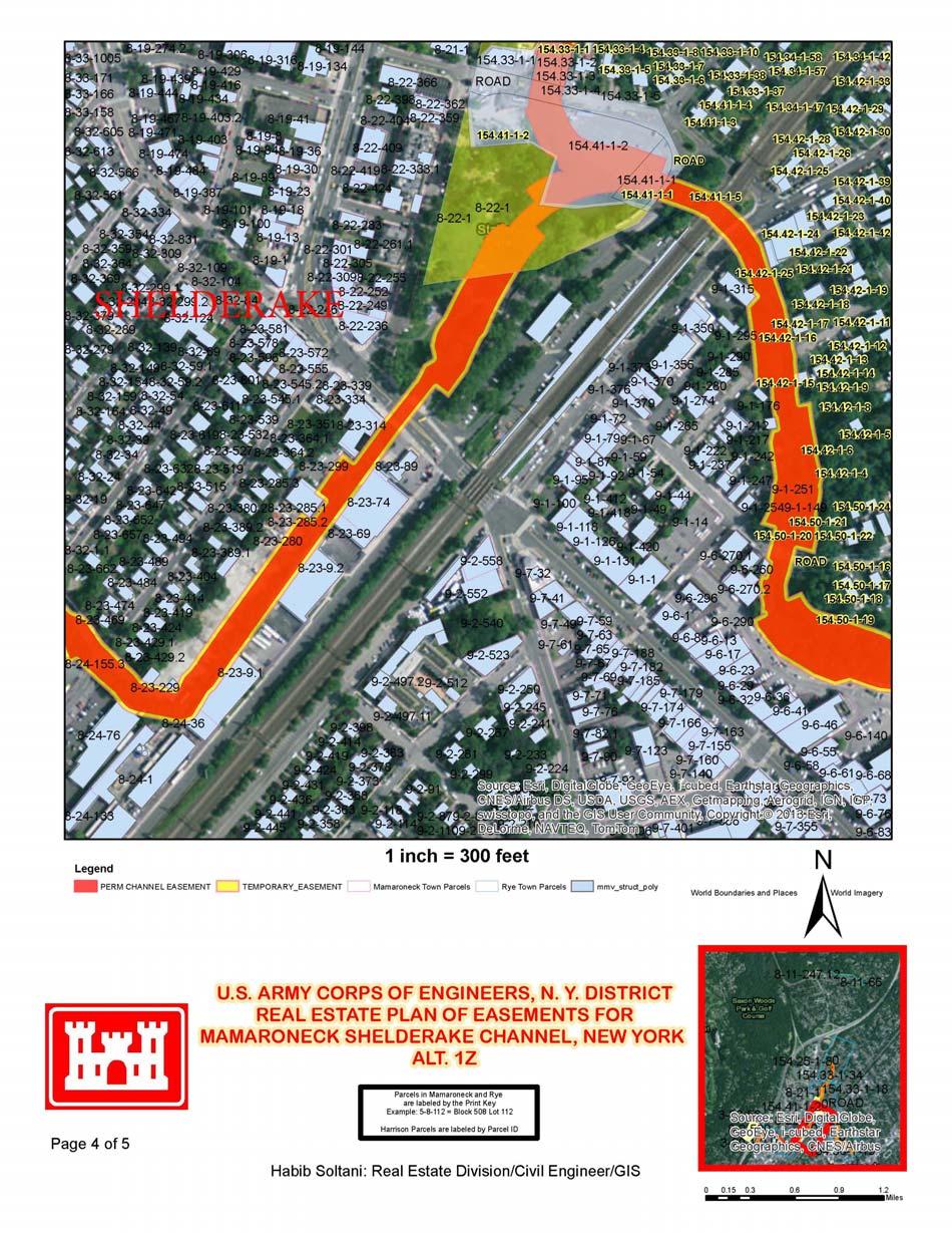
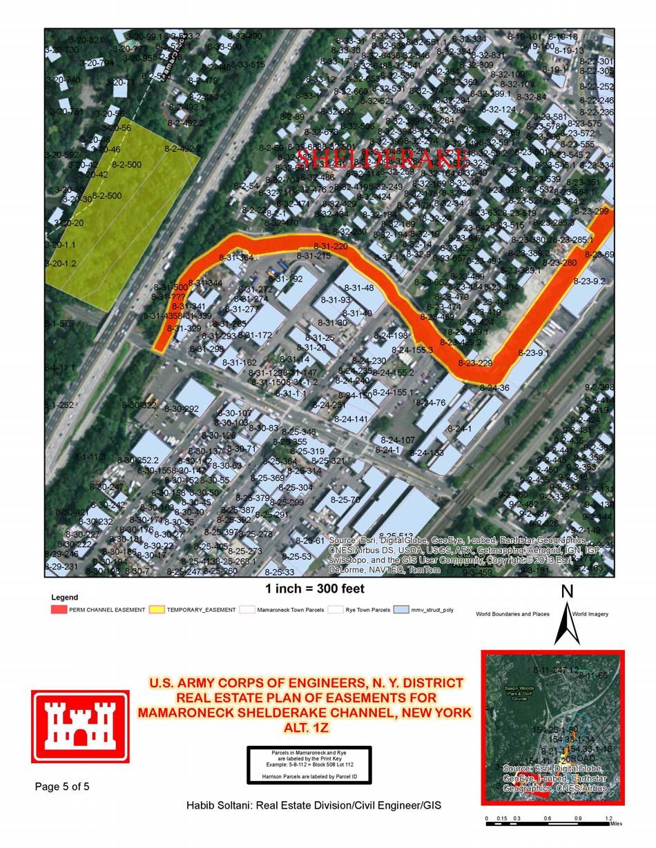
4 2. Statement of Purpose The purpose of this Real Estate Plan (REP) is to present the overall plan describing the minimum real estate requirements for the construction, operation, maintenance, repair and rehabilitation herein referred to as the Nationally Economic Development Plan NED Plan or Plan or Project. This REP is an appendix to the General Reevaluation Report (GRR) to update the studies performed for the 1977 Feasibility Report and the 1989 General Design Memorandum (GDM) prepared by the New York District Corps of Engineers (the District ). 3. Project Purpose and Features a. Project Purpose: The purpose of the Project is to provide reduction of the flood damage to the Village of Mamaroneck, Westchester County, New York and surrounding areas. The NYSDEC requested for the Army Corps of Engineers to re-evaluate the flood risk in the Mamaroneck and Sheldrake River Basin. The District reviewed several plans and identified the National Economic Development Plan (NED Plan). The NED Plan is a technically feasible, environmentally acceptable and economically justified solution for the flood risk of the study area. Plan. b. Plan of Improvements: The following describes the Project components for this This Plan includes channel modification work along both the Mamaroneck and Sheldrake Rivers, with various channel widths, depths and lengths. This Plan includes channel widening and deepening along the Mamaroneck and Sheldrake Rivers within the Village of Mamaroneck. The river will be realigned to its confluence to Mamaroneck Harbor with a 25 foot wide by 8 foot high, 350 foot long culvert that will be installed under the railroad station parking lot to alleviate the poor channel alignment. Trapezoidal channel improvements will consist of a natural bed channel with side slopes of one vertical on two and a half horizontal (1:2.5), and concrete retaining walls will be used where space is limited. Removal and replacement of retaining walls and utilities will be necessary along the channel. Riprap will be used in areas with high velocities. Several small bridges will be removed and one bridge will be replaced. The Non-Federal Sponsor will need to execute the Channel Easement along with the Authorization for Construction. c. Required Lands, Easements, and Rights-of Way (LER): The following describes the LER required for the NED Plan. The parcel data and Standard Estates are provided in Exhibit B and C respectfully. The NED Plan requires a total of acres in permanent easements and 7.80 in temporary easements. This alternative impacts a total of 110 parcels, 88 privately-owned and 22 publicly-owned. 2
5 1. Channel Improvement Easement (Standard Estate No. 8): The NED Plan requires the acquisition of approximately acres in Channel Improvement easements impacting approximately 96 Parcels. 2. Temporary Work Area Easement (Standard Estate No. 15): The NED plan requires the acquisition of approximately 7.80 acres in Temporary Work Area Easements impacting a total of 83 parcels. d. Appraisal Information: An appraisal cost estimate was prepared in November 2014 identifying the land values for this alternative. The land values for this plan are as follows: NED Plan Easement Type Value Channel Improvement Easements----- $483,826 Temporary Work Area Easements---- $2, 655,602 Contingency (10%) $313,943 Total NED Plan: $3,453, Non-Federal Sponsor Owned Lands: The Sponsor owns no LER required for the plan. 5. Non-Standard Estates There are no proposed non-standard estates for the plan. 6. Existing Federal Projects plan. There are no known existing Federal projects that lie either fully or partially within the 7. Federally-owned Lands There are no Federally-owned lands included as part of the LER required for the plan. 8. Navigational Servitude This Project does not require LER within navigable waterways; therefore, navigational servitude does not apply to the Project. 9. Maps 3
6 The Project real estate maps are provided in Exhibit A. 10. Induced Flooding There is no induced flooding associated with this Project. 11. Baseline Cost Estimates for Real Estate The following is the total 01-Lands and Damages costs for the plan: NED Plan Real Estate Cost Total Incidental Cost $1,216,800 Acquisition Cost $3,453, % Contingency (less Land Payments) $243,360 Total Lands and Damages (01- Account) $4,913,531 To avoid double accounting, a 20% contingency was only applied to the Incidental Cost because a contingency is already embedded in the Acquisition Costs through the appraisal cost estimate. Upon approval of the Plan, the Project will be cost-shared (65% Federal and 35% Non-Federal). The following is the total 02-Relocation costs for the plan: NED Plan Real Estate Cost Total Relocation Cost $5,150, % Contingency $3,039,744 Total Relocations (02- Account) $8,190, Compliance with Public Law There are no anticipated relocation assistance benefits; as authorized by Public Law , for the plan. 13. Minerals and Timber Activity 4
7 There are no present or anticipated mineral extraction or timber harvesting activities in the plan. 14. Land Acquisition Experience and Capability of the Non-Federal Sponsor An assessment of the Sponsor s land acquisition experience and capabilities is provided in Exhibit D. 15. Zoning: Application or enactment of zoning ordinances is not anticipated for the Project. 16. Acquisition Schedule The following acquisition schedule will apply to the selected alternative. Milestone PPA Execution Sponsor s Notice to Proceed with Acquisition Phase 1 Authorization for Entry for Construction Phase 1 Certification of Real Estate Phase 1 Ready to Advertise for Construction Date TBD TBD TBD TBD TBD 17. Facility and/or Utility Relocations There are existing sanitary sewer and water pipelines that will be required to be relocated for implementation of the plan. The quantity of pipe work in the NED Plan is 10,703 LF, resulting in an increase of approximately $1.1 million into the 02-Account for relocations. The Plan requires the removal of three public bridges. These bridges will not be replaced, however, a fourth bridge, the Waverly Bridge, will be removed and replaced, thus, allocating an additional $3.4 million into the 02-Account for relocations. 18. Hazardous, Toxic, and Radioactive Waste (HTRW) The ITT Sealectro Site, a New York State Superfund Site, is located along the Sheldrake River within the project area, where retaining walls will be installed. Prior to construction, the District test soils for VOCs and will contact the NYSDEC Remediation staff to determine if contaminated soils are to be disturbed. Soils removed as part of construction may require handling and disposal in accordance with NYSDEC standards. 5
8 19. Project Support Local officials and residents all appear to be supportive of the Project. No opposition has been expressed by public or private persons or organizations on the implementation of the proposed Plan. 20. Notifications to Non-Federal Sponsor Based on its past sponsorship of other Army Corps of Engineers water resource (Civil Works) projects and ongoing discussions during the Project s Feasibility phase, the Non- Federal Sponsor is aware of the risks of acquiring LER required for the Project prior to the signing of the PPA. However, upon the approval of the Plan for the Project, in accordance with paragraph 12-31, Chapter 12, ER , Real Estate Handbook, 20 Nov 85, a formal written notice identifying the risks associated with acquiring the LER for the Project prior to the full execution of the PPA will be provided to the Sponsor. 21. Other Issues a. One Station Plaza, Mamaroneck Train Station, situated within the Project Area is listed on the National Register of Historic Places. There are a number of properties identified as eligible for the New York State and National Registers located within the Project Area, including the Ward Avenue Bridge, the stone wall thematic historic district and the Metro North Railroad Bridge. These historic properties will be adversely by project activities. A Memorandum of Agreement executed in consultation with the New York State Historic Preservation Office and interested parties will be required. b. The Memorandum of Agreement will outline the mitigation required to minimize the adverse effect to the Ward Avenue Bridge and the stone retaining walls as well as a process to determine any required mitigation for the non-structural elements and the project activities at the central abutment of the Metro-North Bridge, as elements and activities are determined. c. There are no known existing encumbrances (i.e., easements, rights-of-way, etc) that would affect, or be affected by, the Project. 22. Point of Contacts: The point of contact for this Real Estate Plan is, Real Estate & Real Property Support Branch Chief, Erica Labeste, who may be contacted at (917) or via Erica.A.Labeste@usace.army.mil. The undersigned, Chief, Real Estate Division, Noreen D. Dresser may be contacted at (917) or via Noreen.D.Dresser@usace.army.mil. 6
9 23. Recommendations: This report has been prepared in accordance with Paragraph of Chapter 12 of the Real Estate Handbook, Corps of Engineers Regulation ER It is recommended that this report be approved. NOREEN DEAN DRESSER District Chief, Real Estate Division Real Estate Contracting Officer 7
10 Exhibit A Real Estate Maps 8
11 9
12 10
13 11
14 12
15 13
16 Exhibit B Parcel Data 14
17 National Economic Development Plan Parcel Data Municipality SEC_BLK_LOT Channel Improvement Easement (acres) Temporary Work Area Easement (acres) Privately Owned Parcels Mamaroneck Rey Town Rey Town Rey Town Rey Town Rey Town Rey Town Rey Town Rey Town Rey Town Rey Town Rey Town Rey Town Rey Town Rey Town Rey Town Rey Town Rey Town Rey Town Rey Town Rey Town Rey Town Rey Town Mamaroneck Mamaroneck Mamaroneck Mamaroneck 8_21_ Mamaroneck Mamaroneck 8_24_ Mamaroneck Mamaroneck 8_24_ Mamaroneck Mamaroneck Mamaroneck Mamaroneck Mamaroneck Mamaroneck
18 Mamaroneck Mamaroneck 8_20_ Mamaroneck Mamaroneck 8_20_ Mamaroneck 8_20_ Mamaroneck Mamaroneck Mamaroneck Mamaroneck Mamaroneck Mamaroneck Mamaroneck Mamaroneck 8_31_ Mamaroneck Mamaroneck 8_21_ Mamaroneck Mamaroneck Mamaroneck Mamaroneck Mamaroneck 8_23_ Mamaroneck 8_23_ Mamaroneck 8_23_ Mamaroneck Mamaroneck Mamaroneck Mamaroneck Mamaroneck Mamaroneck Mamaroneck Publicly Owned Parcels Ray Town _1_ Ray Town _1_ Ray Town _1_ Ray Town _1_ Ray Town _1_ Ray Town _1_ Ray Town _1_ Ray Town _1_ Ray Town _1_ Ray Town _1_ Ray Town _1_ Ray Town _1_
19 Ray Town _1_ Mamaroneck 9_6_ Mamaroneck 8_31_ Mamaroneck 8_22_ Mamaroneck 8_31_ Mamaroneck 8_31_??? Mamaroneck 8_21_ Public Roads
20 Exhibit C Standard Estates 18
21 Channel Improvement Easement (Standard Estate No. 8) A perpetual and assignable right and easement to construct, operate, and maintain channel improvement works on, over and across [Section, Block, and Lot] for the purposes as authorized by the Act of Congress approved in Section 401(a) of the Water Resources Development Act of 1986 (Public Law ), including the right to clear, cut, fell, remove and dispose of any and all timber, trees, underbrush, buildings, improvements and/or other obstructions therefrom; to excavate: dredge, cut away, and remove any or all of said land and to place thereon dredge or spoil material; and for such other purposes as may be required in connection with said work of improvement; reserving, however, to the owners, their heirs and assigns, all such rights and privileges as may be used without interfering with or abridging the rights and easement hereby acquired; subject, however, to existing easements far public roads and highways, public utilities, railroads and pipelines. Temporary Work Area Easement (Standard Estate No. 15. A temporary easement and right-of-way in, on, over and across [Section, Block, and Lot] for a period not to exceed three (3) years, beginning with date possession of the land is granted to the United States, for use by the United States, its representatives, agents, and contractors as a work area, including the right to (borrow and/or deposit fill, spoil and waste material thereon) (move, store and remove equipment and supplies, and erect and remove temporary structures on the land and to perform any other work necessary and incident to the construction of the Mamaroneck and Sheldrake River Flood Damage Reduction Project Mamaroneck, New York, together with the right to trim, cut, fell and remove therefrom all trees, underbrush, obstructions, and any other vegetation, structures, or obstacles within the limits of the right-of-way; reserving, however, to the landowners, their heirs and assigns, all such rights and privileges as may be used without interfering with or abridging the rights and easement hereby acquired; subject, however, to existing easements for public roads and highways, public utilities, railroads and pipelines. 19
22 Exhibit D Non-Federal Sponsor Capability Assessment 20
23 ASSESSMENT OF NON-FEDERAL SPONSOR S REAL ESTATE ACQUISITION CAPABILITY MAMARONECK AND SHELDRAKE RIVER FLOOD DAMAGE REDUCTION PROJECT MAMARONECK, NEW YORK I. Legal Authority. a. Does the sponsor have legal authority to acquire and hold title to real property for project purposes? Yes b. Does the sponsor have the power of eminent domain for this project? Yes c. Does the sponsor have quick-take authority for this project? Yes d. Are any of the lands/interests in land required for the project located outside the sponsor s political boundary? No e. Are any of the lands/interests in land required for the project owned by an entity whose property the sponsor cannot condemn? No II. Human Resource Requirements. a. Will the sponsor s in-house staff require training to become familiar with the real estate requirements of Federal projects including P.L , as amended? No b. If the answer to II.a is yes, has a reasonable plan been developed to provide such training? N/A c. Does the sponsor s in-house staff have sufficient real estate acquisition experience to meet its responsibilities for the project? Yes d. Is the sponsor s projected in-house staffing level sufficient considering its other workload, if any, and the project schedule? Yes e. Can the sponsor obtain contractor support, if required in a timely fashion? Yes f. Will the sponsor likely request USACE assistance in acquiring real estate? No 21
24 III. Other Project Variables. a. Will the sponsor s staff be located within reasonable proximity to the project site? Yes b. Has the sponsor approved the project/real estate schedule/milestones? Yes IV. Overall Assessment. a. Has the sponsor performed satisfactorily on other USACE projects? Yes b. With regard to this project, the sponsor is anticipated to be: highly capable/fully capable/moderately capable/marginally capable/insufficiently capable. If sponsor is believed to be insufficiently capable, provide explanation. Highly Capable. V. Coordination. a. Has this assessment been coordinated with the sponsor? Yes b. Does the sponsor concur with this assessment? Yes NOREEN DEAN DRESSER Chief, Real Estate Division, Real Estate Contracting Officer 22
MAMARONECK AND SHELDRAKE RIVER FLOOD DAMAGE REDUCTION PROJECT MAMARONECK, NEW YORK APPENDIX E REAL ESTATE PLAN
 U.S. Army Corps of Engineers New York District MAMARONECK AND SHELDRAKE RIVER FLOOD DAMAGE REDUCTION PROJECT MAMARONECK, NEW YORK APPENDIX E REAL ESTATE PLAN April 2017 MAMARONECK AND SHELDRAKE RIVER FLOOD
Appendix B Draft Real Estate Plan
 Appendix B Draft Real Estate Plan B-1 REAL ESTATE PLAN Prepared for U.S. Army Corps of Engineers Southwestern Division Little Rock District As of December 3, 2012 Prepared by Ronald Bridges Real Estate
Appendix B Real Estate Plan
 Appendix B Real Estate Plan B-1 REAL ESTATE PLAN Prepared for U.S. Army Corps of Engineers Southwestern Division Little Rock District As of May 1, 2013 Prepared by Ronald Bridges Real Estate Division ANY
Appendix G. Non-Federal Letters of Support and Draft Real Estate Plan
 Appendix G Non-Federal Letters of Support and Draft Real Estate Plan REAL ESTATE PLAN UPPER DELAWARE RIVER WATERSHED FEASABILITY STUDY LIVINGSTON MANOR, NEW YORK 1. GENERAL 2. REAL ESTATE REQUIREMENTS
DRAFT INTEGRATED FEASIBILITY REPORT AND ENVIRONMENTAL ASSESSMENT
 APPENDIX E REAL ESTATE PLAN MT. SINAI MEDICAL CENTER, CONTINUTING AUTHORITIES PROGRAM (CAP) SECTION 14, PROJECT DRAFT INTEGRATED FEASIBILITY REPORT AND ENVIRONMENTAL ASSESSMENT September 2016 DRAFT APPENDIX
Appendix H: Real Estate Plan
 APPENDIX H Spring Creek North Ecosystem Restoration Feasibility Study Appendix H: Real Estate Plan New York District U.S. Army Corps of Engineers October 2016 Revised: 13 April 2017 Spring Creek North
Draft Appendix E. Real Estate Plan. Rahway River Basin, New Jersey Flood Risk Management Feasibility Study. November 2016
 Draft Appendix E Real Estate Plan Rahway River Basin, New Jersey Flood Risk Management Feasibility Study November 2016 New Jersey Department of Environmental Protection U.S. Army Corps of Engineers New
INDIANA HARBOR AND CANAL CONFINED DISPOSAL FACILITY EAST CHICAGO, INDIANA
 INDIANA HARBOR AND CANAL CONFINED DISPOSAL FACILITY EAST CHICAGO, INDIANA APPENDIX J REAL ESTATE Acquisition Branch Real Estate Division Chicago District U.S. Army Corps of Engineers APPENDIX J REAL ESTATE
Appendix C. Real Estate. Brazos Island Harbor, Texas Channel Improvement Project Cameron County, Texas
 Appendix C Real Estate Brazos Island Harbor, Texas Channel Improvement Project Cameron County, Texas U.S. Army Corps of Engineers, Galveston District 2000 Fort Point Road Galveston, Texas 77550 December
APPENDIX M. Real Estate Plan
 APPENDIX M Real Estate Plan Poplar Island Environmental Restoration Project September 2005 General Reevaluation Report (GRR) and Supplemental Environmental Impact Statement (SEIS) REAL ESTATE PLAN (REP)
EDISTO BEACH COASTAL STORM DAMAGE REDUCTION GENERAL INVESTIGATION STUDY APPENDIX K REAL ESTATE
 EDISTO BEACH COASTAL STORM DAMAGE REDUCTION GENERAL INVESTIGATION STUDY APPENDIX K REAL ESTATE Table of Contents REAL ESTATE APPENDIX... I... i SECTION 1. THE REAL ESTATE REPORT... 1 1.1 Statement of Purpose...
HASHAMOMUCK COVE, SOUTHOLD, NEW YORK COASTAL STORM RISK MANAGEMENT FEASIBILITY STUDY APPENDIX F REAL ESTATE PLAN
 U.S. Army Corps of Engineers New York District HASHAMOMUCK COVE, SOUTHOLD, NEW YORK COASTAL STORM RISK MANAGEMENT FEASIBILITY STUDY APPENDIX F REAL ESTATE PLAN AUGUST 2016 HASHAMOMUCK COVE, SOUTHOLD, NEW
DRAFT East Rockaway Inlet to Rockaway Inlet and Jamaica Bay. Atlantic Coast of New York
 DRAFT East Rockaway Inlet to Rockaway Inlet and Jamaica Bay Atlantic Coast of New York APPENDIX E REAL ESTATE PLAN AUGUST 2018 East Rockaway Inlet to Rockaway Inlet and Jamaica Bay Reformulation Study
Delaware River Basin Comprehensive Flood Risk Management Interim Feasibility Study and Integrated Environmental Assessment for New Jersey
 Delaware River Basin Comprehensive Flood Risk Management Interim Feasibility Study and Integrated Environmental Assessment for New Jersey Flooding in the Study Area, April 2005 June 2015 APPENDIX F: Draft
Appendix D: Real Estate
 Shrewsbury River Basin, Sea Bright, New Jersey Coastal Storm Risk Management Feasibility Study Draft Integrated Feasibility Report & Environmental Assessment Appendix D: Real Estate Shrewsbury River Basin,
Draft Continuing Authorities Program Section 1135 Detailed Project Report and Integrated Environmental Assessment
 Appendix G Real Estate Shorty s Island / Meander Reach Ecosystem Restoration Kootenai River, Idaho Draft Continuing Authorities Program Section 1135 Detailed Project Report and Integrated Environmental
APPENDIX F REAL ESTATE
 APPENDIX F REAL ESTATE Real Estate Plan For Broward County, Florida Shore Protection Project Segments II and III General Reevaluation Report 1. Statement Of Purpose. The Real Estate Plan is tentative in
APPENDIX D - REAL ESTATE
 APPENDIX D - REAL ESTATE 1. Purpose Real Estate Plan For Feasibility Study For Lake Lou Yaeger Section 206 Aquatic Ecosystem Restoration Continuing Authorities Project Feasibility Study This report is
CENAN-RE 22 May MEMORANDUM FOR Chief, Planning Division, ATTN: CENAN-PL-F (Alek Petersen)
") CENAN-RE 22 May 2017 MEMORANDUM FOR Chief, Planning Division, ATTN: CENAN-PL-F (Alek Petersen) SUBJECT: May 2017 Real Estate Plan for the Rahway River (Tidal) Basin, Coastal Storm Risk Management Feasibility
CENAN-RE 22 May 2017 MEMORANDUM FOR Chief, Planning Division, ATTN: CENAN-PL-F (Alek Petersen) SUBJECT: May 2017 Real Estate Plan for the Rahway River (Tidal) Basin, Coastal Storm Risk Management Feasibility
WEST SHORE LAKE PONTCHARTRAIN HURRICANE AND STORM DAMAGE RISK REDUCTION STUDY INTEGRATED DRAFT FEASIBILITY REPORT AND ENVIRONMENTAL IMPACT STATEMENT
 WEST SHORE LAKE PONTCHARTRAIN HURRICANE AND STORM DAMAGE RISK REDUCTION STUDY INTEGRATED DRAFT FEASIBILITY REPORT AND ENVIRONMENTAL IMPACT STATEMENT REAL ESTATE PLAN APPENDIX C Annex A: Project Maps Annex
Draft Environmental Impact Statement (EIS)/Environmental Impact Report (EIR) APPENDIX H Real Estate Cost
/Environmental Impact Report (EIR) APPENDIX H Real Estate Cost") Draft Environmental Impact Statement (EIS)/Environmental Impact Report (EIR) APPENDIX H Real Estate Cost US Army Corps of Engineers Corte Madera Creek Flood Risk Management Project October 2018 APPENDIX
Draft Environmental Impact Statement (EIS)/Environmental Impact Report (EIR) APPENDIX H Real Estate Cost US Army Corps of Engineers Corte Madera Creek Flood Risk Management Project October 2018 APPENDIX
APPENDIX E REAL ESTATE PLAN
 APPENDIX E REAL ESTATE PLAN REAL ESTATE PLAN VILLAGE OF BARBOURSVILLE, WATER STREET, STREAMBANK PROTECTION PROJECT CABELL COUNTY, WEST VIRGINIA SECTION 14 1. Authority/Purpose This Real Estate Plan is
APPENDIX G REAL ESTATE
 BUBBLY CREEK, SOUTH BRANCH OF THE CHICAGO RIVER, ILLINOIS FEASIBILITY STUDY APPENDIX G REAL ESTATE DRAFT - NOT FOR DISTRIBUTION APRIL 2015 U.S. Army Corps of Engineers Chicago District Appendix G Real
HUNTING BAYOU FLOOD RISK MANAGEMENT, HARRIS COUNTY, TEXAS DRAFT GENERAL REEVALUATION REPORT AND INTEGRATED ENVIRONMENTAL ASSESSMENT
 HUNTING BAYOU FLOOD RISK MANAGEMENT, HARRIS COUNTY, TEXAS DRAFT GENERAL REEVALUATION REPORT AND INTEGRATED ENVIRONMENTAL ASSESSMENT APPENDIX 6 REAL ESTATE PLAN June 2014 HARRIS COUNTY FLOOD CONTROL DISTRICT
Appendix K. Real Estate Plan
 Appendix K. Real Estate Plan REAL ESTATE PLAN DELTA ISLANDS AND LEVEES FEASIBILITY STUDY (DELTA STUDY) 20 June 2018 PREPARED BY THE SACRAMENTO DISTRICT U.S. ARMY CORPS OF ENGINEERS 1 TABLE OF CONTENTS
Downtown Montauk Stabilization Project. Real Estate Plan Appendix
 Downtown Montauk Stabilization Project Real Estate Plan Appendix October 2014 Table of Contents Page 1. Introduction and General Information 1 a. Authority 2 b. History 2 c. Location Project Study Area
REAL ESTATE PLAN APPENDIX G
 Pacific Ocean Division REAL ESTATE PLAN APPENDIX G Alaska District UNALASKA (DUTCH HARBOR) CHANNELS UNALASKA, ALASKA Real Estate Division Alaska District U.S. Army Corps of Engineers TABLE OF CONTENTS
Draft Integrated Feasibility Report and Environmental Assessment and Draft Finding of No Significant Impact
 Draft Integrated Feasibility Report and Environmental Assessment and Draft Finding of No Significant Impact APPENDIX F: REAL ESTATE Whittier, Alaska June 2018 Pacific Ocean Division DRAFT REAL ESTATE
DRAFT REAL ESTATE PLAN APPENDIX D JEFFERSON COUNTY ECOSYSTEM RESTORATION FEASIBILITY STUDY
 DRAFT REAL ESTATE PLAN APPENDIX D JEFFERSON COUNTY ECOSYSTEM RESTORATION FEASIBILITY STUDY (NOTE: This page intentionally left blank.) This Real Estate Plan has been prepared in accordance with ER 405-1-12
Appendix D Real Estate Plan
 Appendix D Real Estate Plan Matagorda Ship Channel, Port Lavaca, Texas Feasibility Report and Environmental Impact Statement, Review of Completed Projects, Calhoun and Matagorda Counties May 2018 (NOTE:
APPENDIX C REAL ESTATE PLAN BOULEVARD RESACA, BROWNSVILLE, TX CAMERON COUNTY, TEXAS
 APPENDIX C REAL ESTATE PLAN BOULEVARD RESACA, BROWNSVILLE, TX CAMERON COUNTY, TEXAS November 19, 2016 Table of Contents Purpose... 3 Project Authority... 3 Project Location and Description... 3 Non-Federal
UPPER MISSISSIPPI RIVER RESTORATION FEASIBILITY REPORT WITH INTEGRATED ENVIRONMENTAL ASSESSMENT
 UPPER MISSISSIPPI RIVER RESTORATION FEASIBILITY REPORT WITH INTEGRATED ENVIRONMENTAL ASSESSMENT McGregor Lake HABITAT REHABILITATION AND ENHANCEMENT PROJECT POOL 10, UPPER MISSISSIPPI RIVER MILE 635-634
Final General Reevaluation Report and Final Environmental Impact Statement. Hurricane Protection and Beach Erosion Control
 Final General Reevaluation Report and Final Environmental Impact Statement on Hurricane Protection and Beach Erosion Control WEST ONSLOW BEACH AND NEW RIVER INLET (TOPSAIL BEACH), NORTH CAROLINA Appendix
APPENDIX H. Real Estate Plan
 INTEGRATED FEASIBILITY REPORT AND ENVIRONMENTAL IMPACT STATEMENT COASTAL STORM DAMAGE REDUCTION BOGUE BANKS, CARTERET COUNTY NORTH CAROLINA APPENDIX H Real Estate Plan US Army Corps of Engineers Wilmington
REAL ESTATE PLAN. Final Integrated General Reevaluation Report and Supplemental Environmental Impact Statement
 REAL ESTATE PLAN Final Integrated General Reevaluation Report and Supplemental Environmental Impact Statement Mississippi River, Baton Rouge to the Gulf of Mexico Mississippi River-Gulf Outlet, Louisiana,
Skagit River Flood Risk Management General Investigation Skagit County, Washington. Draft Feasibility Report and Environmental Impact Statement
 General Investigation Skagit County, Washington Draft Feasibility Report and Environmental Impact Statement May 2014 Real Estate Requirements of Selected Plan This Real Estate Plan Summary (REP) is presented
Real Estate Plan Beaver Lake Water Supply Reallocation White River Rogers, Arkansas. 20 April 2017
 Real Estate Plan Beaver Lake Water Supply Reallocation White River Rogers, Arkansas 20 April 2017 Prepared For US Army Corps of Engineers Southwestern Division Little Rock District Prepared By Jeremy R.
APPENDIX D REAL ESTATE PLAN
 APPENDIX D REAL ESTATE PLAN APPENDIX D REAL ESTATE PLAN TABLE OF CONTENTS 1. STATEMENT OF PURPOSE 2. REFERENCES 3. AUTHORIZATION 4. BACKGROUND 5. LOCATION 6. REAL ESTATE REQUIREMENTS 7. OWNERSHIP OF REAL
DRAFT REAL ESTATE PLAN APPENDIX C GULF INTRACOASTAL WATERWAY BRAZOS RIVER FLOODGATES AND COLORADO RIVER LOCKS SYSTEMS FEASIBILITY STUDY
 DRAFT REAL ESTATE PLAN APPENDIX C GULF INTRACOASTAL WATERWAY BRAZOS RIVER FLOODGATES AND COLORADO RIVER LOCKS SYSTEMS FEASIBILITY STUDY This Real Estate Plan has been prepared in accordance with ER 405-1-12
GENERAL RE-EVALUATION REPORT APPENDIX B: REAL ESTATE SAVANNAH HARBOR EXPANSION PROJECT Chatham County, Georgia and Jasper County, South Carolina
 GENERAL RE-EVALUATION REPORT APPENDIX B: REAL ESTATE SAVANNAH HARBOR EXPANSION PROJECT Chatham County, Georgia and Jasper County, South Carolina January 2012 (Revised July 2012) US Army Corps of Engineers
AGREEMENT TO ACQUIRE LANDS BETWEEN THE DEPARTMENT OF THE ARMY ST. PAUL DISTRICT, CORPS OF ENGINEERS AND. THE CITY OF City, State
 AGREEMENT TO ACQUIRE LANDS BETWEEN THE DEPARTMENT OF THE ARMY ST. PAUL DISTRICT, CORPS OF ENGINEERS AND THE CITY OF City, State FOR CONDEMNATION ON BEHALF OF THE SPONSOR BY THE CORPS OF ENGINEERS FOR THE
Dredged Material Management Plan Atlantic Intracoastal Waterway Port Royal Sound, South Carolina to Cumberland Sound, Georgia November 2015
 Dredged Material Management Plan Atlantic Intracoastal Waterway Port Royal Sound, South Carolina to Cumberland Sound, Georgia November 2015 Appendix H: Real Estate US Army Corps of Engineers South Atlantic
UPPER MISSISSIPPI RIVER RESTORATION FEASIBILITY REPORT WITH INTEGRATED ENVIRONMENTAL ASSESSMENT
 UPPER MISSISSIPPI RIVER RESTORATION FEASIBILITY REPORT WITH INTEGRATED ENVIRONMENTAL ASSESSMENT BEAVER ISLAND HABITAT REHABILITATION AND ENHANCEMENT PROJECT POOL 14, UPPER MISSISSIPPI RIVER MILES 513.0-517.0
APPENDIX F REAL ESTATE PLAN. Redwood City Harbor Navigation Improvement Feasibility Study, Redwood City, California
 APPENDIX F REAL ESTATE PLAN Redwood City Harbor Navigation Improvement Feasibility Study, Redwood City, California PREPARED FOR THE SAN FRANCISCO DISTRICT SOUTH PACIFIC DIVISION 20 April 2015 PREPARED
APPENDIX H REAL ESTATE REQUIREMENTS
 Malden River Ecosystem Restoration Detailed Project Report APPENDIX H REAL ESTATE REQUIREMENTS April 2007 Malden River Ecosystem Restoration Real Estate Report 1. PURPOSE: The Detailed Project Report
APPENDIX H REAL ESTATE PLAN
 APPENDIX H REAL ESTATE PLAN This page intentionally left blank. APPENDIX H REAL ESTATE PLAN DALLAS FLOODWAY FEASIBILITY STUDY DATE OF REPORT January 31, 2014 PREPARED BY REAL ESTATE DIVISION U.S. ARMY
BEACH STORM DAMAGE REDUCTION EASEMENT
 STATE OF FLORIDA COUNTY OF WALTON WALTON COUNTY, FL HURRICANE & STORM DAMAGE REDUCTION PROJECT FILE/REACH#: PARCEL ID#: BEACH STORM DAMAGE REDUCTION EASEMENT KNOW ALL MEN BY THESE PRESENTS, that for and
Southwest Coastal Louisiana Study
 REAL ESTATE PLAN Annex 1: Project Maps Annex 2: Assessment of Non-Federal Sponsor s Acquisition Capability Annex 3: Non-Material Deviation from Standard Estate Perpetual Access Easement Annex 4: Baseline
Appendix C REAL ESTATE PLAN
 Appendix C RAL STAT PLAN Section 203 Integrated Feasibility Report and Draft nvironmental Impact Statement RAL STAT PLAN HOUMA NAVIGATION CANAL CHANNL DPNING MIL 36.3 TO MIL 3.7 TRRBONN PARISH, LOUISIANA
Appendix J. Real Estate Plan
 Appendix J Real Estate Plan Real Estate Plan Louisiana Coastal Area Near-Term Ecosystem Restoration Plan Medium Diversion at White Ditch 1. PURPOSE Title VII of the Water Resources Development Act of 2007
Land Management Plan Fargo-Moorhead (FM) Area Flood Risk Reduction Project Version 1
 Area Flood Risk Reduction Project Version 1") Land Management Plan Fargo-Moorhead (FM) Area Flood Risk Reduction Project Version 1 Prepared for Fargo-Moorhead Area Flood Diversion Board of Authority July 12, 2012 REV 1 Contents Section Page Acronyms
Land Management Plan Fargo-Moorhead (FM) Area Flood Risk Reduction Project Version 1 Prepared for Fargo-Moorhead Area Flood Diversion Board of Authority July 12, 2012 REV 1 Contents Section Page Acronyms
Mississippi River Ship Channel Gulf to Baton Rouge, LA Integrated General Reevaluation Report And Supplemental Environmental Impact Statement
 APPENDIX B Real Estate Plan B-1.0 PROJECT PURPOSE, DESCRIPTION, LOCATION AND DESCRIPTION OF THE LANDS, EASEMENTS, RIGHTS-OF-WAY, RELOCATIONS AND DISPOSAL (LERRD) REQUIRED The purpose of this Real Estate
DEPARTMENT OF THE ARMY OFFICE OF THE CHIEF OF ENGINEERS WASHINGTON, D.C
 DEPARTMENT OF THE ARMY OFFICE OF THE CHIEF OF ENGINEERS WASHINGTON, D.C. 20314-1000 REPLY TO ATTENTION OF: CECW-PM (10-1-7a) THE SECRETARY OF THE ARMY 1. I submit for transmission to Congress my report
U.S. Army Corps of Engineers Charleston District APPENDIX E CHARLESTON HARBOR POST 45 CHARLESTON, SOUTH CAROLINA. Real Estate
 U.S. Army Corps of Engineers Charleston District APPENDIX E CHARLESTON HARBOR POST 45 CHARLESTON, SOUTH CAROLINA Real Estate May 2015 Table of Contents REAL ESTATE APPENDIX E... I... i... i SECTION 1.
1. GENERAL 2. REAL ESTATE REQUIREMENTS
 1. GENERAL APPENDIX E REAL ESTATE PLAN FOR THE SECTION 205, TOOKANY CREEK FLOOD RISK MANAGEMENT FEASIBILITY STUDY TOWNSHIP, MONTGOMERY COUNTY PENNSYLVANIA 2. REAL ESTATE REQUIREMENTS a. Description of
APPENDIX D REAL ESTATE DRAFT. MOBILE HARBOR, MOBILE, ALABAMA Integrated General Reevaluation Report With Supplemental Environmental Impact Statement
 APPENDIX D REAL ESTATE DRAFT MOBILE HARBOR, MOBILE, ALABAMA Integrated General Reevaluation Report With Supplemental Environmental Impact Statement Table of Contents 1. Purpose of the Real Estate Plan
MIDDLE RIO GRANDE FLOOD PROTECTION, BERNALILLO TO BELEN, NM PROJECT BERNALILLO AND VALENCIA COUNTIES, NEW MEXICO. Appendix I Real Estate Plan
 MIDDLE RIO GRANDE FLOOD PROTECTION, BERNALILLO TO BELEN, NM PROJECT BERNALILLO AND VALENCIA COUNTIES, NEW MEXICO Appendix I Real Estate Plan LOS ANGELES DISTRICT ASSET MANAGEMENT US Army Corps Of Engineers
City of East Providence
 City of East Providence 145 TAUNTON AVENUE, EAST PROVIDENCE STATE OF RHODE ISLAND AND PROVIDENCE PLANTATIONS 02914-4505 TEL. (401) 435-7521 FAX (401) 438-1719 TDD (401) 431-1633 CITY MANAGER PETER GRACZYKOWSKI
PUGET SOUND NEARSHORE ECOSYSTEM RESTORATION
 PUGET SOUND NEARSHORE ECOSYSTEM RESTORATION APPENDIX C REAL ESTATE PLAN Integrated Feasibility Report and Environmental Impact Statement This page was intentionally left blank to facilitate double sided
DEPARTMENT OF THE ARMY OFFICE OF THE CHIEF OF ENGINEERS WASHINGTON. D.C MAR
 DEPARTMENT OF THE ARMY OFFICE OF THE CHIEF OF ENGINEERS WASHINGTON. D.C. 2031 4-1 000 MAR 3 1 2006 CEMP-NAD (1 0-1-7a) THE SECRETARY OF THE ARMY 1. I submit for transmission to Congress my report on the
MAMARONECK & SHELDRAKE RIVERS NEW YORK FLOOD RISK MANAGEMENT GENERAL REEVALUATION REPORT FOR THE VILLAGE OF MAMARONECK
 MAMARONECK & SHELDRAKE RIVERS NEW YORK FLOOD RISK MANAGEMENT GENERAL REEVALUATION REPORT FOR THE VILLAGE OF MAMARONECK APPENDIX C5: COST ESTIMATES JANUARY 2016 Table of Contents Introduction... C1 Basis
DEPARTMENT OF THE ARMY U.S. Army Corps of Engineers Washington, DC Regulation No May 2015
 CEMP-CR DEPARTMENT OF THE ARMY U.S. Army Corps of Engineers Washington, DC 20314-1000 ER 405-1-19 Regulation No. 405-1-19 29 May 2015 Real Estate ACQUISITION BY CONDEMNATION PROCEEDINGS 1. Purpose. Engineer
WESTMINSTER, EAST GARDEN GROVE FLOOD RISK MANAGEMENT STUDY
 Ver. 24 Oct 2018 WESTMINSTER, EAST GARDEN GROVE FLOOD RISK MANAGEMENT STUDY FEASIBILITY REPORT AND INTEGRATED ENVIRONMENTAL IMPACT REPORT REAL ESTATE PLANNING REPORT SEPTEMBER 2018 APPENDIX D DRAFT REAL
APPENDIX D REAL ESTATE
 APPENDIX D REAL ESTATE American River Watershed Common Features General Reevaluation Report Real Estate Plan February 2015 1 Cover Photos courtesy of the Sacramento District: Sacramento Weir during operation
Appendix F. Real Estate
 Appendix F Real Estate U.S. Army Corps of Engineers Galveston District Southwestern Division Appendix F Real Estate Plan for Coastal Texas Protection and Restoration Study Integrated Feasibility Report
Road Rights of Way And Obstructions
 CEAO Superintendents & Mechanics Conference Road Rights of Way And Obstructions Chris Bauserman, PE, PS Delaware County Engineer October 14, 2015 Introduction Topics Road Right-of-Way Rights of others
Real Estate Plan Appendix
 Fire Island Inlet to Moriches Inlet Stabilization Project Real Estate Plan Appendix 20 December 2013 Revised June 2014 FIMI Real Estate Plan June 2014 Page 1 Table of Contents Page 1. General 3 2. Real
SEQRA (For Land Surveyors) Purpose of this Presentation
 Purpose of this Presentation") SEQRA (For Land Surveyors) Purpose of this Presentation Understand the basics and legal requirements of SEQRA Recognize the role that Land Surveyors play in the SEQRA Identify the problems posed by SEQRA
SEQRA (For Land Surveyors) Purpose of this Presentation Understand the basics and legal requirements of SEQRA Recognize the role that Land Surveyors play in the SEQRA Identify the problems posed by SEQRA
EASEMENT AGREEMENT. hereinafter called Grantor, (whether grammatically singular or plural) and the:
 and the:") EASEMENT AGREEMENT THIS EASEMENT AGREEMENT, made and entered into as of the day of,, by and between: hereinafter called Grantor, (whether grammatically singular or plural) and the: hereinafter called Distributor.
EASEMENT AGREEMENT THIS EASEMENT AGREEMENT, made and entered into as of the day of,, by and between: hereinafter called Grantor, (whether grammatically singular or plural) and the: hereinafter called Distributor.
Texas Land Trust Conference March 6, 2015
 Texas Land Trust Conference March 6, 2015 James D. Bradbury James D. Bradbury, PLLC Austin Fort Worth An Overview Unique area of law where the government can take private property Protected by the US Constitution
The Drainage Control Regulations
 1 The Drainage Control Regulations Repealed by Saskatchewan Regulations 89/2015 (effective October 16, 2015) Formerly Chapter D-33.1 Reg 1 (effective August 18, 1981) as amended by Saskatchewan Regulations
Flood Hazard Development Permit Application & Permit Forms. For Communities with Coastal Velocity Zones [60.3(e)] CONTENTS
![Flood Hazard Development Permit Application & Permit Forms. For Communities with Coastal Velocity Zones [60.3(e)] CONTENTS](/thumbs/76/74346075.jpg "Flood Hazard Development Permit Application & Permit Forms. For Communities with Coastal Velocity Zones [60.3(e)] CONTENTS") Flood Hazard Development Permit Application & Permit Forms For Communities with Coastal Velocity Zones [60.3(e)] CONTENTS 1. Decision Tree 2. Flood Hazard Development Permit Application 3. Flood Hazard
Flood Hazard Development Permit Application & Permit Forms For Communities with Coastal Velocity Zones [60.3(e)] CONTENTS 1. Decision Tree 2. Flood Hazard Development Permit Application 3. Flood Hazard
SUBCHAPTER 02C - SECONDARY ROADS SECTION SECTION SECONDARY ROADS
 SUBCHAPTER 02C - SECONDARY ROADS SECTION SECTION.0100 - SECONDARY ROADS Note: The Department of Transportation publishes a volume entitled "Minimum Design and Construction Criteria for Subdivision Streets"
Appendix A. Definitions
 Definitions 1. Terms Defined. Words contained in this are those having a special meaning relative to the purposes of this Ordinance. Words not listed in this section shall be defined by reference to: (1)
DWR REAL ESTATE COORDINATION PLAN
 DWR REAL ESTATE COORDINATION PLAN Exhibit E DWR PROPERTY ACQUISTION PLAN EXHIBIT E Revised Date: 5 10 18 DWR PROPERTY ACQUISTION PLAN EXHIBIT E Revised Date: 5-10-2018 California WaterFix Real Estate Coordination
S U B D I V I S I O N AGREEMENT
 S U B D I V I S I O N AGREEMENT THIS AGREEMENT made this 17th day of January, 2006, by and between Peachtree Properties, L.L.C., (hereinafter referred to as "Developer"); SANITARY AND IMPROVEMENT DISTRICT
EXHIBIT 2 NOTICE OF INTENTION OF THE BOARD OF SUPERVISORS. OF TilE COUNTY OF ORANGE, CALIFORNIA, ACTING AS
 OF REAL PROPERTY DETERMINING THE NECESSITY OF ACQUISITION BY EMINENT DOMAIN DISTRICT, TO CONSIDER FOR ADOPTION A RESOLUTION THE GOVERNING BOARD OF THE ORANGE COUNTY FLOOD CONTROL OF TilE COUNTY OF ORANGE,
DRIVEWAY/ACCESS PERMIT APPLICATION INSTRUCTIONS Douglas County Trunk Highways
 DRIVEWAY/ACCESS PERMIT APPLICATION INSTRUCTIONS Douglas County Trunk Highways It is the policy of the Douglas County Highway Department that permission must be obtained to construct or maintain a driveway
Bill of Rights. Cities of 5,000 or more population; adoption or amendment of charter
 CITATION TITLE HEADINGS TEXT Tex. Const. art. I, 17 Taking, Damaging, or Destroying Property for Public Use; Special Privileges and Immunities; Control of Privileges and Franchises. Bill of Rights (a)
DEED AND DEDICATION FOR PUBLIC RIGHT OF WAY
 TO : BOARD OF DIRECTORS FROM : GARY PLATT, EXEC. DIRECTOR BUSINESS AND OPERATIONS SUBJECT : CITY OF STANWOOD CONSTRUCTION EASEMENT AND RIGHT-OF-WAY DEDICATION DATE : MARCH 17, 2009 TYPE : ACTION NEEDED
CHAPTER 24 F FLOOD ZONE OVERLAY DISTRICT
 CHAPTER 24 OVERLAY DISTRICT SECTION 24.01 PURPOSE It is the intent of this district to apply special regulation to the use of land in those areas subject to periodic inundation. Such regulation is deemed
BRISTOL CONSERVATION COMMISSION INLAND WETLANDS AGENCY FORM IW-1 (Application for a Wetlands Permit)
") APPLICATION NO. BRISTOL CONSERVATION COMMISSION INLAND WETLANDS AGENCY FORM IW-1 (Application for a Wetlands Permit) DATE FILED: APPROVED: DENIED: 1. APPLICANT: Name: Signature: Address: City: State: Zip
APPLICATION NO. BRISTOL CONSERVATION COMMISSION INLAND WETLANDS AGENCY FORM IW-1 (Application for a Wetlands Permit) DATE FILED: APPROVED: DENIED: 1. APPLICANT: Name: Signature: Address: City: State: Zip
Town of Jupiter Island Delegated Mangrove Authority For the State of Florida
 Town of Jupiter Island Delegated Mangrove Authority For the State of Florida Mangroves are regulated by the State of Florida. The Town of Jupiter Island is a delegated regulatory agency for the State for
SAMPLE 1 INDUCEMENT AND INDEMNITY AGREEMENT LETTER
 SAMPLE 1 INDUCEMENT AND INDEMNITY AGREEMENT LETTER (Date) Ohio Housing Finance Agency 57 E. Main Street Columbus, OH 43215-5135 RE: (Project Name) Colleagues: We have this day filed with the Ohio Housing
ST. JOHNS COUNTY, FLORIDA South Ponte Vedra Beach, Vilano Beach, and Summer Haven Reaches
 ST. JOHNS COUNTY, FLORIDA South Ponte Vedra Beach, Vilano Beach, and Summer Haven Reaches COASTAL STORM RISK MANAGEMENT PROJECT DRAFT INTEGRATED FEASIBILITY STUDY AND ENVIRONMENTAL ASSESSMENT APPENDIX
Town of Surf City. City Council Presentation April 2, 2013 PETER A. RAVELLA, PRINCIPAL PAR CONSULTING, LLC
 Town of Surf City City Council Presentation April 2, 2013 PETER A. RAVELLA, PRINCIPAL CONSULTING, LLC I. Review Workshop schedule & Input SC-NTB Federal Project Plan 1550 Funding Contributors You re Not
THIS DECLARATION OF RESTRICTIVE COVENANTS is made this day of, 20, by ("Covenantor"). RECITALS
. RECITALS") Model for Use with Permits Without Mitigation Plans STATE OF COUNTY OF DECLARATION OF RESTRICTIVE COVENANTS THIS DECLARATION OF RESTRICTIVE COVENANTS is made this day of, 20, by ("Covenantor"). RECITALS
Model for Use with Permits Without Mitigation Plans STATE OF COUNTY OF DECLARATION OF RESTRICTIVE COVENANTS THIS DECLARATION OF RESTRICTIVE COVENANTS is made this day of, 20, by ("Covenantor"). RECITALS
NC General Statutes - Chapter 153A Article 15 1
 Article 15. Public Enterprises. Part 1. General Provisions. 153A-274. Public enterprise defined. As used in this Article, "public enterprise" includes: (1) Water supply and distribution systems. (2) Wastewater
ARLINGTON COUNTY, VIRGINIA. County Board Agenda Item Meeting of November 17, 2012
 ARLINGTON COUNTY, VIRGINIA County Board Agenda Item Meeting of November 17, 2012 DATE: November 9, 2012 SUBJECT: Approval of an Agreement of Sale Between BREOF Thomas REO, LLC and the County Board of Arlington
CURRENT THROUGH PL , APPROVED 11/11/2009
 CURRENT THROUGH PL 111-98, APPROVED 11/11/2009 TITLE 10. ARMED FORCES SUBTITLE A. GENERAL MILITARY LAW PART IV. SERVICE, SUPPLY, AND PROCUREMENT CHAPTER 159. REAL PROPERTY; RELATED PERSONAL PROPERTY; AND
Date Received: Application Complete? YES / NO
 OFFICE USE ONLY Section 22 (Official Plan Amendment) Section 34 (Zoning Amendment), Section 36 (Holding Zone Removal), Section 41 (Site Plan Approval) and Section 45 (Minor Variance) of the Planning Act
NARRATIVE (GUIDELINES)
") NARRATIVE (GUIDELINES) SECTION I ACQUISITION (IF APPLICABLE, if not do not include) To be completed in narrative form by projects involving acquisitions in addition to Section II but is not required for
NARRATIVE (GUIDELINES) SECTION I ACQUISITION (IF APPLICABLE, if not do not include) To be completed in narrative form by projects involving acquisitions in addition to Section II but is not required for
CITY OF FORT COLLINS NATURAL AREAS AND CONSERVED LANDS EASEMENT POLICY
 CITY OF FORT COLLINS NATURAL AREAS AND CONSERVED LANDS EASEMENT POLICY Adopted January 3, 2012 PURPOSE: The purpose of the policy statement is to clarify the policies and procedures of the City of Fort
Attached is a Clinton Township Zoning Permit Application and requirements for issuance of a permit.
 To Whom It May Concern: Attached is a Clinton Township Zoning Permit Application and requirements for issuance of a permit. The fee for the permit application is $75.00, which shall be made payable to
Green and Barren Lock and Dam Disposition Study Louisville District, US Army Corps of Engineers February Appendix F: Real Estate Interests
 Green and Barren Lock and Dam Louisville District, US Army Corps of Engineers February 2014 Appendix F: Real Estate Interests Appendix F. Real Estate 1.0 General In 1991, the USACE conducted a study to
February 6, Operations Division Regulatory Branch (North) ID No. LRL dlz
 ID No. LRL dlz") DEPARTMENT OF THE ARMY U.S. ARMY ENGINEER DISTRICT, LOUISVILLE CORPS OF ENGINEERS INDIANAPOLIS REGULATORY OFFICE 8902 OTIS AVENUE, SUITE S106B INDIANAPOLIS, INDIANA 46216 February 6, 2013 Operations Division
DEPARTMENT OF THE ARMY U.S. ARMY ENGINEER DISTRICT, LOUISVILLE CORPS OF ENGINEERS INDIANAPOLIS REGULATORY OFFICE 8902 OTIS AVENUE, SUITE S106B INDIANAPOLIS, INDIANA 46216 February 6, 2013 Operations Division
ELK RAPIDS TOWNSHIP ANTRIM COUNTY, MICHIGAN ORDINANCE NO
 ELK RAPIDS TOWNSHIP ANTRIM COUNTY, MICHIGAN ORDINANCE NO. 3-2011 AN ORDINANCE TO REPLACE THE SUBDIVISION CONTROL ORDINANCE WITH A NEW SUBDIVISION DEVELOPMENT ORDINANCE, IN ACCORD WITH THE LAND DIVISION
Submittal of the Minutes from the March 9, 2011, April 5, 2011, and April 19, 2011 Cabinet Meetings.
 AGENDA BOARD OF TRUSTEES OF THE INTERNAL IMPROVEMENT TRUST FUND JUNE 16, 2011 Attachments to the items below can be viewed at the following link: http://www.dep.state.fl.us/secretary/cab/public_notices.htm
OFFICE OF REAL ESTATE
 OFFICE OF REAL ESTATE DATE: October 25, 2017 TO: FROM: RE: Users of the Real Estate Manual Wayne Pace, Manager Acquisition Unit Changes and Updates to the Real Estate Manual The only current and accurate
ARTICLE I. IN GENERAL
 Adopted by City Council on December 7, 2009 AN ORDINANCE TO AMEND AND REORDAIN CHAPTER 10 (WATER PROTECTION) OF THE CODE OF THE CITY OF CHARLOTTESVILLE, 1990, AS AMENDED, BY DELETING SECTIONS 10-51 AND