WEST SHORE LAKE PONTCHARTRAIN HURRICANE AND STORM DAMAGE RISK REDUCTION STUDY INTEGRATED DRAFT FEASIBILITY REPORT AND ENVIRONMENTAL IMPACT STATEMENT
|
|
|
- Frederick Johnston
- 6 years ago
- Views:
Transcription
1 WEST SHORE LAKE PONTCHARTRAIN HURRICANE AND STORM DAMAGE RISK REDUCTION STUDY INTEGRATED DRAFT FEASIBILITY REPORT AND ENVIRONMENTAL IMPACT STATEMENT REAL ESTATE PLAN APPENDIX C Annex A: Project Maps Annex B: Assessment of Non-Federal Sponsor s Acquisition Capability Annex C: Baseline Cost Estimates/Charts of Accounts Annex D: Non-Material Deviation from Standard Estate Temporary Access Easement Annex E: Perpetual Underground Piling Easement Annex F: Facility/Utility Relocations Annex G: Real Estate Policy Guidance Letter No. 31 Real Estate Support To Civil Works Planning Paradigm (3x3x3) 1
2 Contents PURPOSE OF THE REAL ESTATE PLAN... 3 PROJECT DESCRIPTION AND LOCATION... 3 PROJECT AUTHORIZATION... 5 NON-FEDERAL SPONSOR... 5 LANDS, EASEMENTS & RIGHTS-OF-WAY... 6 ACCESS... 7 STAGING... 8 BORROW... 8 MITIGATION... 8 INDUCED FLOODING... 8 NON-FEDERAL SPONSOR OWNED LER... 8 ESTATES... 9 FEE EXCLUDING MINERALS (With Restriction on Use of the Surface) 9 FLOOD PROTECTION LEVEE EASEMENT... 9 TEMPORARY WORK AREA EASEMENT...9 TEMPORARY ACCESS EASEMENT (Non-Material Deviation from Standard Estate.10 EXISTING FEDERAL PROJECTS WITHIN THE LER REQUIRED FOR THE PROJECT...11 FEDERALLY OWNED LANDS WITHIN THE LER FOR THE PROJECT...11 NAVIGATION SERVITUDE...11 BASELINE COST ESTIMATES/CHART OF ACCOUNTS (COAS)...11 UNIFORM RELOCATION ASSISTANCE (PL , TITLE II AS AMENDED)...12 TIMBER/MINERAL/ROW CROP ACTIVITY...12 OYSTER LEASES...12 ZONING ORDINANCES...12 ACQUISITION SCHEDULE...12 FACILITY/UTILITY RELOCATIONS...13 HAZARDOUS, TOXIC AND RADIOACTIVE WASTE...14 LANDOWNER CONCERNS
. The information contained herein is tentative in nature for planning purposes only.")

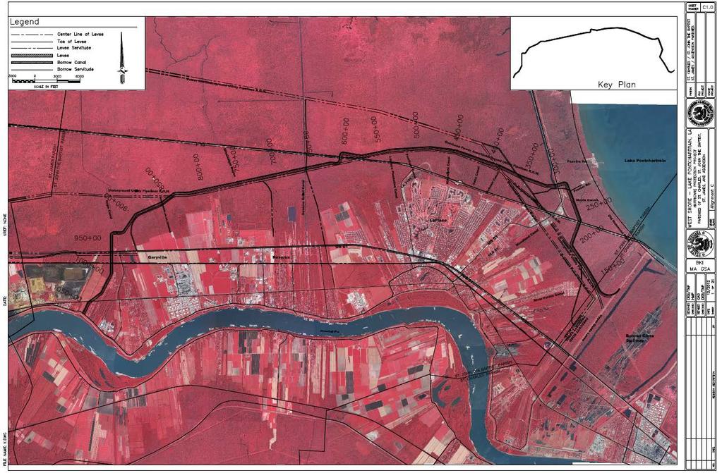
3 PURPOSE OF THE REAL ESTATE PLAN This Real Estate Plan (REP) presents the real estate requirements and costs for the Feasibility Report for the West Shore Lake Pontchartrain Hurricane and Storm Damage Risk Reduction Project (WSLP). The information contained herein is tentative in nature for planning purposes only. At the time the REP was prepared, the Project Delivery Team (PDT) had reached the TSP milestone, and feasibility level analysis was just beginning. Footprint maps which identify locations of access, staging, borrow and other project features were not available. The information contained within this REP is based on assumptions made by the PDT, and estimated acreages of project features. This REP does not fully conform to the requirements of Chapter 12 (ER ). Once feasibility level analysis is complete, the REP will be revised to conform with Chapter 12. PROJECT DESCRIPTION AND LOCATION The project is a hurricane and storm damage reduction study based on ER The project purpose is to assess the needed hurricane storm damage risk reduction measures in portions of St. Charles, St. John the Baptist, and St. James Parishes. The project is located within portions of St. Charles, St. John the Baptist, and St. James Parishes, Louisiana. It is bounded on the east by the Bonnet Carré Spillway upper guide levee, on the north by Lakes Pontchartrain and Maurepas, on the west by the Ascension/St. James Parish line, and on the south by the Mississippi River Levee (MRL) (Figure 1-1). Figure 1: Study Area 3

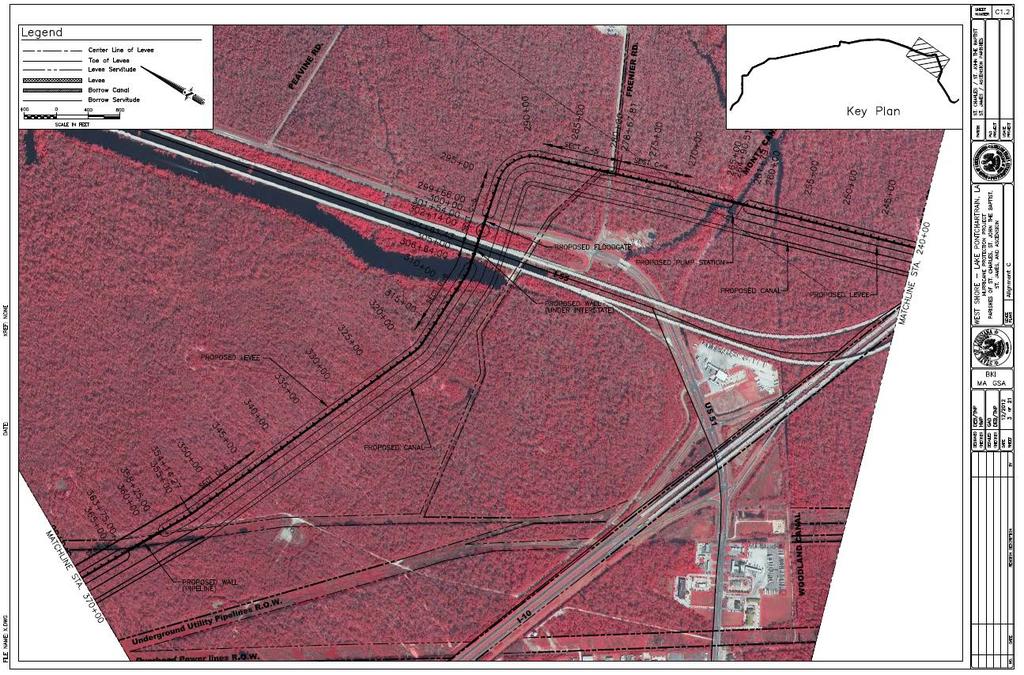
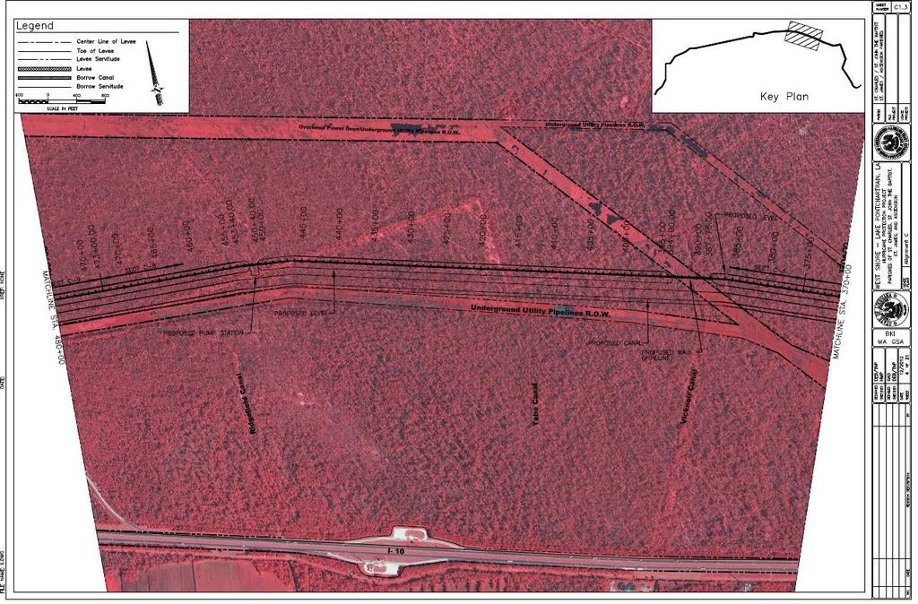
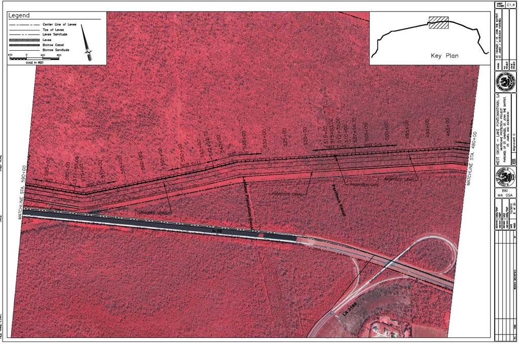
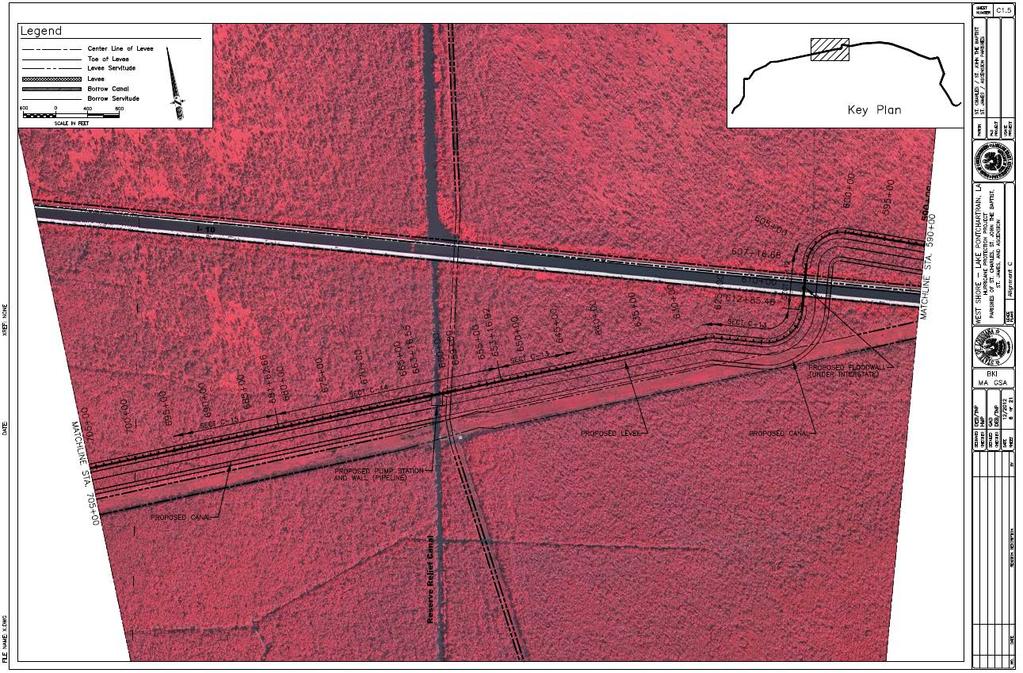
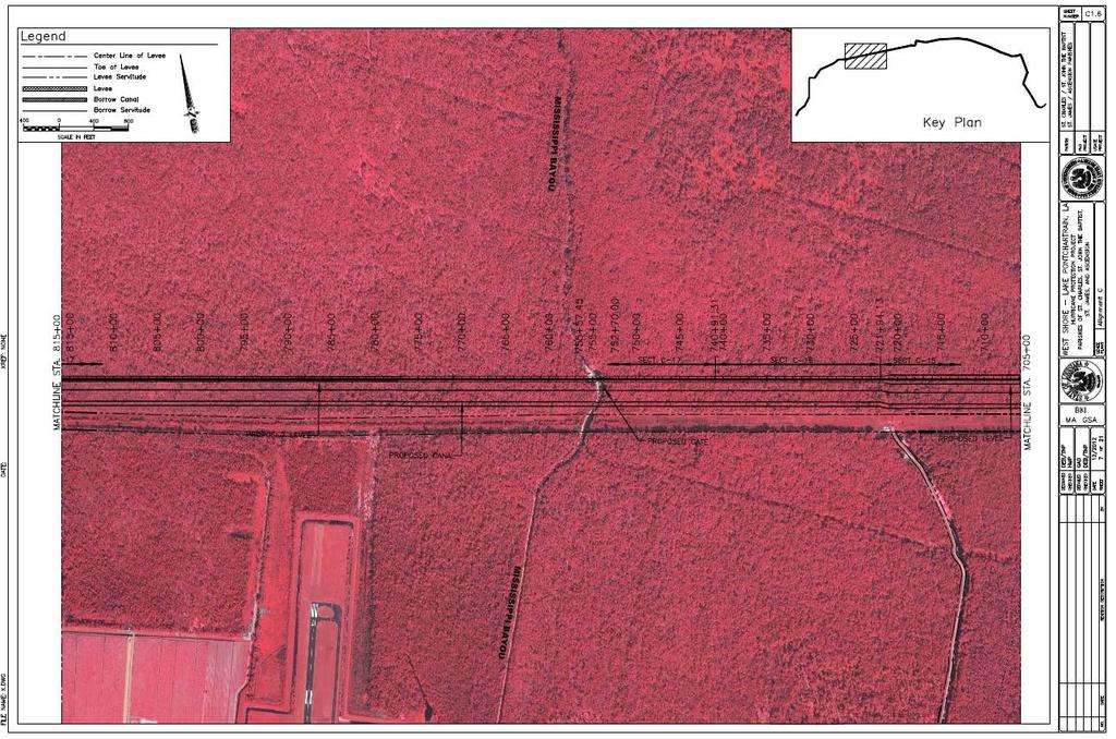
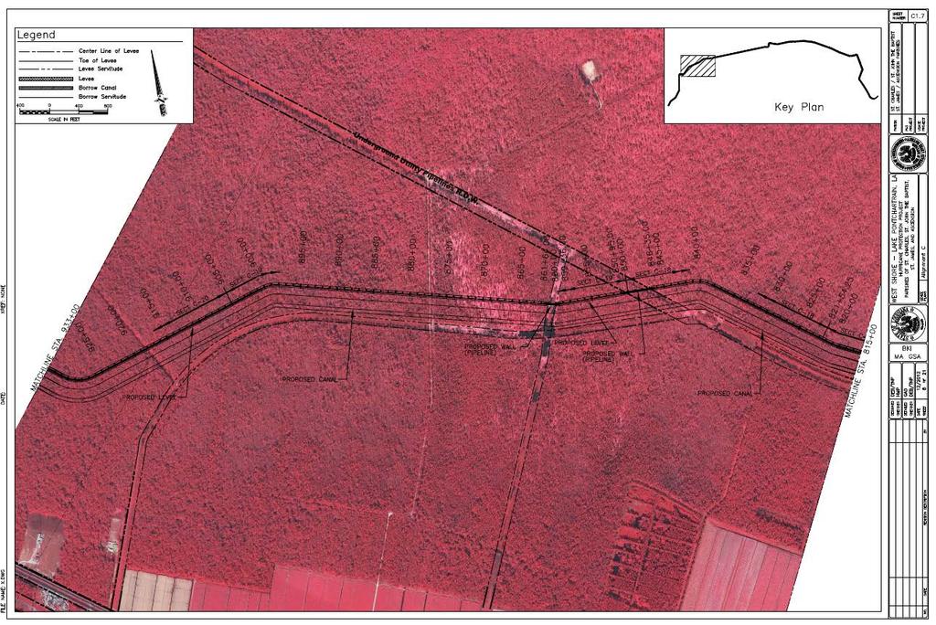
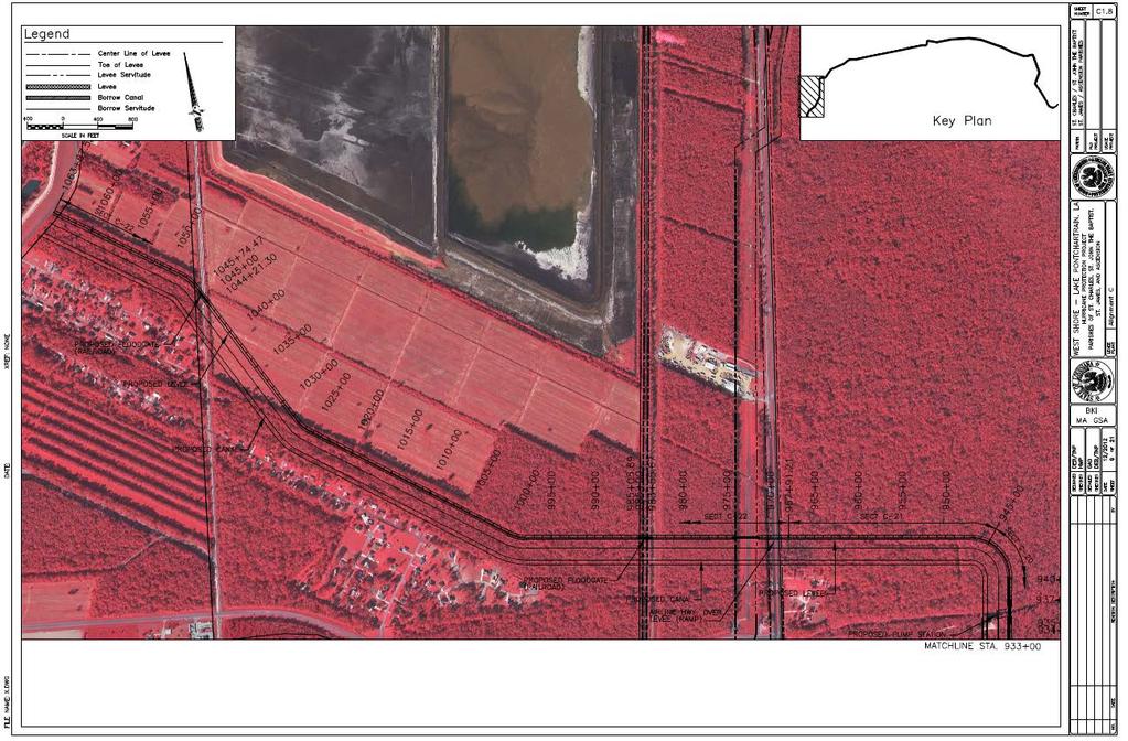
4 The tentatively selected plan (TSP) lies between the West Guide levee of the Bonnet Carré Spillway to the US-51 interchange, where it tracks north across US-51 and along a pipeline corridor. At I-10 near the Belle Terre exit, the tentatively selected plan crosses the interstate and follows the pipeline corridor through wetlands until it reaches the St. John the Baptist and St. James Parish line. At that point, the alignment turns south and extends to the location where the ground elevation is equal to or higher than the levee design crest elevation (near the MRL). Figure 1-2 below shows the alignment of the TSP with respect to the project area, and maps showing a more detailed view of the TSP alignment are located within Exhibit A (maps C1 thru C8). This Alternative will also implement non-structural measures which include elevation of structures and acquisition of structures in the western portion of the study area in the communities of Gramercy, Lutcher and Grand Point. Figure 2: TSP Alignment The TSP alignment consists largely of earthen levees, but does contain T-walls for crossings of roadways and pipelines. Based on the preliminary level of design, levee elevations would range from NAVD88 on the eastern reaches near the Bonnet Carré Spillway to +7.0 NAVD88 in the western portion of the project area. Approximately 26,124 cubic yards of aggregate limestone would be used to build a road on the levee crown for operation and maintenance purposes. A conveyance canal at a depth of -10 ft. NAVD88 would be situated adjacent to the levee. The alignment is approximately miles and includes 5,304 feet of t-wall, 208 feet of drainage gates, 288 feet of roadway gates, two railway gates, 36 pipeline crossings and four 4
5 pump stations. In addition, this Alternative will implement non-structural measures which include elevation of structures and acquisition of structures in the western portion of the study area in the communities of Gramercy, Lutcher and Grand Point. PROJECT AUTHORIZATION Two Congressional resolutions authorize the Study. The first was adopted on July 29, 1971, by the U.S. House of Representatives Committee on Public Works. The resolution reads: RESOLVED BY THE COMMITTEE ON PUBLIC WORKS OF THE HOUSE OF REPRESENTATIVES, UNITED STATES, that the Board of Engineers for Rivers and Harbors is hereby requested to review the report of the Chief of Engineers on Lake Pontchartrain and Vicinity, Louisiana, published as House Document No. 231, 89 th Congress, First Session, and other pertinent reports, with a view to determining whether modifications to the recommendations contained therein are advisable at this time, with particular reference to providing additional levees for hurricane protection and flood control in St. John the Baptist Parish and that part of St. Charles Parish west of the Bonnet Carré' Spillway." The second resolution was adopted by the U.S. Senate Committee on Public Works on September 20, The resolution reads: "RESOLVED BY THE COMMITTEE ON PUBLIC WORKS OF THE UNITED STATES SENATE, that the Board for Rivers and Harbors is hereby requested to review\ the report of the Chief of Engineers on Lake Pontchartrain and Vicinity, Louisiana, published as House Document No. 231, 89th Congress, First Session, and other pertinent reports, with a view to determining whether modifications to the recommendations contained therein are advisable at this time, for hurricane protection and flood control in St. James Parish." NON-FEDERAL SPONSOR In 1998, the USACE and the Pontchartrain Levee District (PLD) executed a Feasibility Cost Sharing Agreement and Project Study Plan for the study. An amendment was executed in The Louisiana Coastal Protection Restoration Authority Board (CPRAB), will be required to serve as the Non-Federal Sponsor (NFS) for construction and Operation, Maintenance, Repair, Rehabilitation and Replacement (OMRR&R) if this project is authorized. The Coastal Protection and Restoration Authority Board (CPRAB) is an agency for the State of Louisiana that was created by LA Act 8 (2005) for multiple purposes, one of which is the provision of hurricane storm damage risk reduction measures. The Coastal Protection and Restoration Authority (CPRA), also a State agency, is the implementing agency of CPRAB, which has been given the authority to acquire and hold these lands. CPRAB, as the Non-Federal Sponsor, is charged with responsibility for the provision of all lands, easements, and rights-of-way, including those required for relocations, the borrowing of material, and the disposal of dredged or excavated material; performing or ensuring the performance of all relocations; and constructing all improvements required on lands, easements, and rights-of-way to enable the disposal of dredged or excavated material all as 5
6 determined by the Government to be required or to be necessary for the construction, operation, and maintenance of the project (LERRDs). While CPRAB has condemnation authority, it does not, at this time, possess quick-take condemnation authority. If that condition continues when the Real Estate acquisition process commences, CPRAB will have to reach agreement with another state agency that has quicktake condemnation authority in order to have that agency perform any quick-take condemnation measures on behalf of CPRAB that may be necessary for construction of the project. Assessment of the Non-Federal Sponsor s Real Estate Acquisition Capability for CPRAB is attached as Exhibit B. The Non-Federal Sponsor has been found to be fully capable of performing acquisition of the LER required for the project, conditioned upon its obtaining quicktake condemnation authority in the future or its ability to enter into a Cooperative Endeavor Agreement with a state agency that has quick-take condemnation authority. LANDS, EASEMENTS & RIGHTS-OF-WAY The TSP structural alignment primarily impacts wetlands. A large portion of the project alignment lies within state owned lands. An estimated 120 private landowners will be affected by this project feature. The PDT worked to locate the right-of-way limits for the proposed levee sections to coincide with existing rights-of-way from highways, pipelines, etc. in order to avoid remainder parcels that were non-functional to the landowners. The TSP alignment consists largely of earthen levees, but does contain T-walls for crossings of roadways and pipelines. Based on the preliminary level of design, levee elevations would range from NAVD88 on the eastern reaches near the Bonnet Carré Spillway to +7.0 NAVD88 in the western portion of the project area. Approximately 26,124 cubic yards of aggregate limestone would be used to build a road on the levee crown for operation and maintenance purposes. A conveyance canal at a depth of -10 ft. NAVD88 would be situated adjacent to the levee. The alignment is approximately miles and includes 5,304 feet of t-wall, 208 feet of drainage gates, 288 feet of roadway gates, two railway gates, 36 pipeline crossings and four pump stations. This alternative will also implement a non-structural project feature, which includes elevation of an estimated 1,481 structures and acquisition of an estimated 90 structures. More detailed information regarding the non-structural features will be provided once feasibility level analysis is complete. A standard perpetual levee easement will be acquired for the construction of the levee and T- walls as well as the right of way necessary for the gates associated with T-walls. A nonstandard underground piling easement will also be acquired for the T-wall (this estate was approved by Headquarters in 2006 for the HSDRRS project and future floodwall projects, as shown in Exhibit F). A standard Drainage Ditch Easement will be acquired for the conveyance channel. A standard temporary work area easement will be acquired for staging areas. Mitigation areas will be acquired in fee, excluding minerals (with restrictions on use of surface). 6
7 A non-material deviation will be made to the standard road easement to provide for the temporary, non-exclusive rights necessary for temporary access routes (refer to Exhibit D). For state owned lands within the project alignment, the state will issue a Grant of Particular Use to the government. Refer to the section entitled State Owned LER below for more details regarding the Grant of Particular Use. For the non-structural project features, the PDT has not performed detailed analysis on the acquisitions or elevations. At this time, there has not been sufficient evaluation to determine specific structures to be included in this feature. A detailed evaluation of the work entailed in structure raising will be accomplished during feasibility level design. At that time, appropriate real estate interests to be acquired for the non-structural features will be determined, and the real estate costs will be refined and included within the final REP. Full coordination will take place with the vertical team. Table 1 below demonstrates the acreage, ownerships affected, and proposed estate for each project feature. This information is tentative in nature and will be revised following feasibility level design: Table 1: Acreage Project Feature # # Proposed Estate Acres Tracts/Ownerships Access 3 1* Temporary Access Easement Levee/T-wall Perpetual Levee Easement/ Perpetual Underground Piling Easement Conveyance Canal ** 120* Drainage Ditch Easement Gates 50 4* Fee, Excluding Minerals Pump Stations 5 4* Fee, Excluding Minerals Staging TBD TBD Temporary Work Area Easement Mitigation 774 TBD Fee, Excluding Minerals Nonstructural 1571 TBD Acquisition Borrow TBD Refer to discussion of Borrow within LER descriptions below *Landowners shown with an asterisk are assumed to be the same landowners that will be affected by the levee/t-wall features. Total estimated landowners affected by the structural features is 120. **Acreage for the conveyance canal is calculated within the acreage for the Levee/T-Wall. The Final REP will separate this acreage. Note: Acreages and number of ownerships above are estimates, and will be revised following feasibility level of design. ACCESS Access for construction of the project will be directly from the right-of-way of the Upper Guide Levee, US-51, US-61 and La. 44. No additional right-of-way will be required at these access points. One access point at Airport Road will require 3 acres of additional right-of-way. A Temporary Access Easement will be acquired for this portion of the project. 7
8 STAGING The majority of staging areas for construction of this project will be located within the Right-of- Way for the levee footprint or existing Right-of-Way. Additional Right-of-Way will be required within a few reaches. Staging area locations and acreages for LER to be acquired will be determined during feasibility level design. A standard Temporary Work Area Easement will be acquired for the additional right-of-way required for this portion of the project. BORROW Borrow material for the project would come from the Bonnet Carré Spillway, which is owned in fee by the federal government, or from alternative borrow sources not yet identified. A borrow analysis will be prepared to identify potential borrow sources. The CPRAB will be required to acquire all LER for borrow. MITIGATION Alternative C (TSP) would directly impact a total of approximately 719 acres of wetlands including primarily forested wetlands/swamp along the reach of the alignment located north of US Highway 61, and approximately 55 acres of dry and/or wet BLH located along the reach of the alignment located south of US Highway 61. The standard Fee, Excluding Minerals (With Restriction on Use of Surface) estate would be acquired for mitigation areas. The specific location of mitigation areas will be determined during feasibility level design. It is anticipated that a large portion of the mitigation areas may fall within state owned lands. INDUCED FLOODING Modeling is currently underway as a part of feasibility level design. Pump stations will be used to drain the project area. These pump stations will be operated so that the construction of project features will not induce flooding on the protected side of the project. In the event that modeling results indicate there could be induced flooding outside the protected area, a takings analysis will be prepared and a determination will be made as to whether additional real estate interests need to be acquired. NON-FEDERAL SPONSOR OWNED LER Portions of the levee footprint and potential mitigation sites lie within lands owned by the State of Louisiana. The State of Louisiana is prohibited by Constitutional mandate from granting easements over its property or selling the property in fee interest. The Grant of Particular Use is the instrument executed by the State which allows the Federal government to enter its property and construct the project (in Federal terms, this would be called Right-of-Entry). The document discusses the work to be performed on the land and the duration of occupancy. The state will issue a Grant of Particular Use for the project area which lies within state owned water bottoms. The rights delineated in the Grant of Particular Use issued by the State will be similar to the language in the standard perpetual levee easement. 8
9 The Non-Federal Sponsor will be notified in writing of the risks of acquiring LERRDs before execution of the PPA. ESTATES The following standard estates will be required for the project: FEE EXCLUDING MINERALS (With Restriction on Use of the Surface) The fee simple title to the land, subject, however, to existing easements for public roads and highways, public utilities, railroads and pipelines; excepting and excluding all (coal) (oil and gas), in and under said land and all appurtenant rights for the exploration, development, production and removal of said (coal) (oil and gas), but without the right to enter upon or over the surface of said land for the for the purpose of exploration, development, production and removal therefrom of said (coal) (oil and gas). FLOOD PROTECTION LEVEE EASEMENT A perpetual and assignable right and easement in (the land described in Schedule A) (Tracts Nos,, and ) to construct, maintain, repair, operate, patrol and replace a flood protection (levee) (floodwall)(gate closure) (sandbag closure), including all appurtenances thereto; reserving, however, to the owners, their heirs and assigns, all such rights and privileges in the land as may be used without interfering with or abridging the rights and easement hereby acquired; subject, however, to existing easements for public roads and highways, public utilities, railroads and pipelines. DRAINAGE DITCH EASEMENT A perpetual and assignable easement and right-of-way in, over and across (the land described in Schedule A) (Tracts Nos., and ) to construct, maintain, repair, operate, patrol and replace a drainage ditch, reserving, however, to the owners, their heirs and assigns, all such rights and privileges in the land as may be used without interfering with or abridging the rights and easement hereby acquired; subject, however, to existing easements for public roads and highways, public utilities, railroads and pipelines. TEMPORARY WORK AREA EASEMENT A temporary easement and right-of-way in, on, over and across (the land described in Schedule A) (Tracts Nos., and ), for a period not to exceed, beginning with date possession of the land is granted to the United States, for use by the United States, its representatives, agents, and contractors as a (borrow area) (work area), including the right to (borrow and/or deposit fill, spoil and waste material thereon) (move, store and remove equipment and supplies, and erect and remove temporary structures on the land and to perform any other work necessary and incident to the construction of the Project, together with the right to trim, cut, fell and remove therefrom all trees, underbrush, obstructions, and any other vegetation, structures, or obstacles within the limits of the right-of-way; reserving, however, to the landowners, their heirs and assigns, all such rights and privileges as may be used without 9
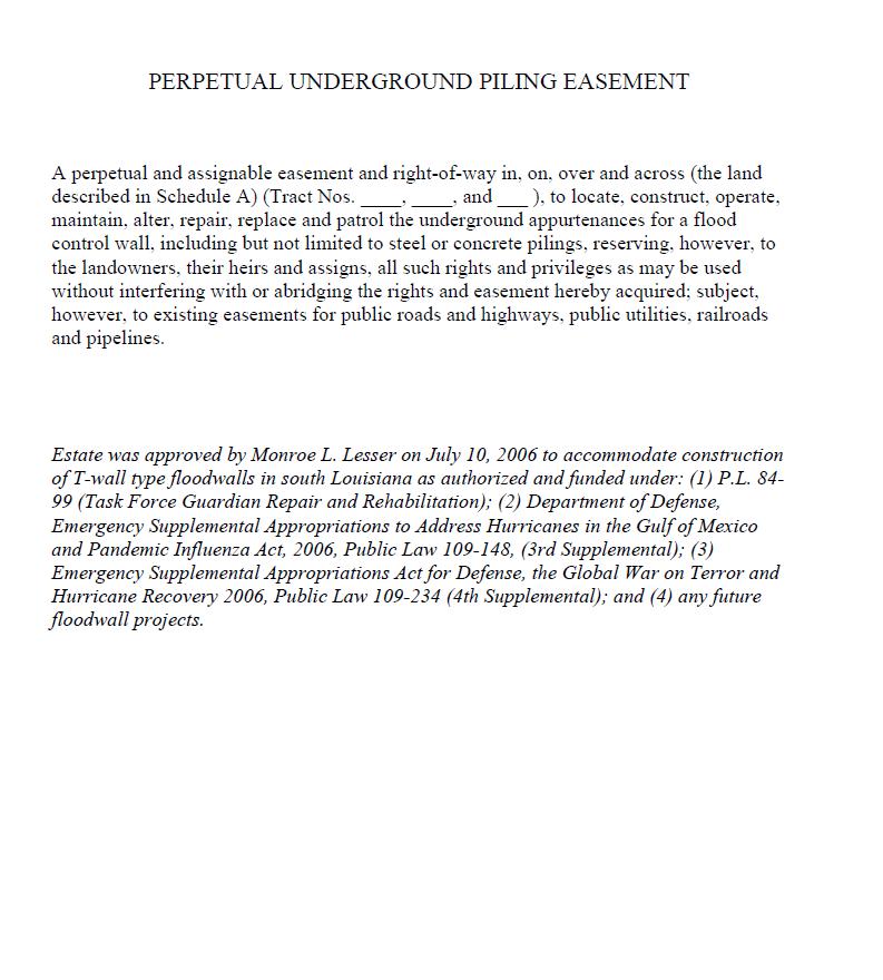
10 interfering with or abridging the rights and easement hereby acquired; subject, however, to existing easements for public roads and highways, public utilities, railroads and pipelines. TEMPORARY ACCESS EASEMENT (Non-Material Deviation from Standard Estate) A non-exclusive and assignable temporary easement for a period not to exceed years beginning with date possession of the land is granted to the United States, for use by the United States, its representatives, agents, and contractors as an access route and/or right-of-way in, on, over and across (the land described in Schedule A) (Tracts Nos., and ); together with the right to trim, cut, fell and remove therefrom all trees, underbrush, obstructions and other vegetation, structures, or obstacles within the limits of the right-of-way, reserving, however, to the owners, their heirs and assigns, all such rights and privileges as may be used without interfering with or abridging the rights and easement hereby acquired, including the right to cross over the right-of-way as access to their adjoining land; subject, however, to existing easements for public roads and highways, public utilities, railroads and pipelines. Approval of the Temporary Access Easement (Non-Material Deviation from Standard Estate) is attached as Exhibit D. Perpetual Underground Piling Easement Currently designed T-wall type floodwalls require a non-standard Perpetual Underground Piling Easement in addition to the standard Perpetual Flood Protection Levee/Floodwall Easement for construction, operation and maintenance. A copy of the Perpetual Underground Piling Easement which was approved in 2006 for HSDRRS projects and any future floodwall projects is attached as Exhibit E. The typical T-wall type floodwall includes an underground battered piling supported foundation. To accommodate construction, a standard Perpetual Flood Protection Levee/Floodwall Easement will extend out from the centerline of the sheetpile floodwall, providing surface and underground rights to construct and maintain the floodwall, including the sheetpile wall and the initial segment of the underground support piles extending out from the sheetpile. A nonstandard Perpetual Underground Piling Easement will allow for construction and maintenance of the remaining segment of the underground pilings that extend out beyond the outer limits of standard levee/floodwall easement on both the flood and protected sides of the floodwall. This underground easement will not unnecessarily restrict the surface use of these areas as would the standard Perpetual Flood Protection Levee/Floodwall Easement and will significantly reduce potential landowner relocations requiring payments for certain improvements (structures) and P.L Title II benefits. Avoiding unnecessary perpetual surface restrictions will preserve the ordinary surface rights of residential property owners. Acquiring the non-standard Perpetual Underground Piling Easement also adheres to the policy set forth in ER (Section 12-9) of acquiring the minimum interest in real property necessary to support the project. 10
11 EXISTING FEDERAL PROJECTS WITHIN THE LER REQUIRED FOR THE PROJECT Reintroduction of Mississippi River Water Into Maurepas Swamp Project (Hope Canal) The project is located within the WSLP project alignment. However, the project is currently in the engineering and design phase, and no LERRDs have been acquired. FEDERALLY OWNED LANDS WITHIN THE LER FOR THE PROJECT Borrow material for the project would come from the Bonnet Carré Spillway, which is owned in fee by the federal government. USACE is the managing agency over this land. NAVIGATION SERVITUDE The navigation servitude is the dominant right of the Government under the Commerce Clause of the U.S. Constitution to use, control and regulate the navigable waters of the United States and submerged lands thereunder. The project does not require LER within any navigable watercourses. Therefore, the Federal Navigational Servitude will not be invoked for this project. BASELINE COST ESTIMATES/CHART OF ACCOUNTS (COAs) A Chart of Accounts for the tentatively selected plan is included in Exhibit C of this Real Estate Plan. The estimated total cost for Real Estate Acquisition is $84,700,000. This includes $3,283,000 for the structural features and $81,417,000 for non-structural features. The costs for structural features include land payments as well as administrative costs and incremental costs associated with acquiring the real estate interests, as well as costs for potential condemnations. Cost estimates will be revised after completion of feasibility level design. Costs for the non-structural features are ROM level estimates which will be refined once the appropriate real estate interests are determined. Displaced persons and business may be entitled to relocation assistance benefits (P.L , Title II as amended). Because real estate costs did not exceed 10% of total project costs, a gross appraisal was not prepared for this project (refer to Real Estate Policy Guidance Letter Non. 31-Real Estate Support to Civil Works Planning Paradigm (3x3x3) dated January 10, 2013, attached as Exhibit G). LER costs are based on a cost estimate prepared by the Appraisal Branch in April It is noted that a large percentage of total estimated real estate costs include consideration of URA relocations costs, and the value of actual land to be acquired is well below 10% of total project costs. Note: The cost estimates do not reflect the costs for facilities/utilities relocations. Refer to the section entitled Facility/Utility Relocations for more information. 11
12 UNIFORM RELOCATION ASSISTANCE (PL , Title II as amended) Approximately 1,571 landowners may be impacted by the non-structural project features. Relocation assistance benefits to residents may be applicable, including storage of household goods, moving costs, lodging, incidentals, differential payments, etc. Businesses could be entitled to receive advisory services, reimbursement for actual reasonable moving costs, reestablishment costs which are capped at $10,000, and certain reasonable and necessary incidental costs associated with the relocation. TIMBER/MINERAL/ROW CROP ACTIVITY The Louisiana Department of Natural Resources provides a Strategic Online Natural Resources Information System (SONRIS), which contains up-to-date information on oil & gas activity in the state of Louisiana. Review of this information indicated that although there are oil and gas wells within the study area, there are no active wells within the projected TSP alignment. This information will be reviewed and confirmed following feasibility level design. With the exception of the acquisition of the standard Fee Excluding Minerals (With Restrictions on the Use of the Surface) estate over certain lands which has the potential to impact mineral rights, the other estates have no impact on mineral rights and the Government will not acquire mineral rights to any of the LER required for the project. Over lands where the fee estate is being acquired, mineral rights will be subordinated. Mineral right owners can still explore for minerals through directional drilling. There are approximately 80 acres of agricultural land impacted by the project. Any timber present is included in the overall appraised value of the land. For properties impacted by the project which are in agricultural use, the owner will be allowed to harvest crops prior to acquisition. OYSTER LEASES There are no oyster leases located within the project study area. ZONING ORDINANCES There will be no application or enactment of zoning ordinances in lieu of, or to facilitate, acquisition for structural features of this project. As the plans are developed for non-structural features during feasibility level design, it is possible that there will be certain building restrictions in areas where elevations or floodproofing measures are proposed, and in areas where there may be buy-out acquisitions. ACQUISITION SCHEDULE The following acquisition schedule for structural project features is based on the premise that the project will impact approximately 120 landowners for the levee alignment. It is assumed that the project will be constructed in sections. A detailed acquisition schedule will be prepared during PED once the 95% plans and specifications are prepared for each section of the project. The schedule below provides the total amount of time to complete the acquisition of real estate rights for mitigation and for the construction of the levee alignment and other project features 12
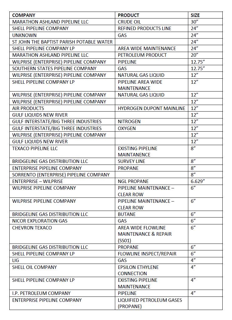
13 based on the preliminary information available at this time. This schedule is only for purposes of the feasibility study, and will be updated following feasibility level of design. 1) TOD, Mapping 1 year 2) Obtain Title & Appraisals 2 years 3) Negotiations 4 years 4) Closing 2 years 5) Eminent Domain Proceedings 6 years At this time, a schedule for non-structural project feature implementation has not been determined. This will be re-evaluated during feasibility level analysis. FACILITY/UTILITY RELOCATIONS Relocation data is collected and detailed by the USACE New Orleans District, Engineering Division, Design Services Branch Relocations Team. At the time of this report, information was not available to a feasibility level of analysis. There are an estimated 36 pipeline relocations as part of the tentatively selected plan. A preliminary list of pipeline relocations is attached as Exhibit F. The estimated cost of pipeline relocations is $28,080,000. Real Estate Guidance issued for 3x3x3 studies indicates that if the costs of relocation of facilities and utilities is less than 30% of project costs, a preliminary compensable interest report should not be prepared (refer to Real Estate Policy Guidance Letter Non. 31-Real Estate Support to Civil Works Planning Paradigm (3x3x3) dated January 10, 2013, attached as Exhibit G). Because the estimated cost of relocations does not exceed 30% of total project cost, an Attorney s Preliminary Opinion of Compensable Interest was not prepared for this project. Rather, once feasibility level of design is complete, a Relocations Report will be prepared and the Real Estate Plan will include a relocations assessment indicating which relocations are covered by the substitute facilities doctrine. A Final Attorney s Opinion of Compensability will be prepared once the PPA is signed. A separate Relocations Report, containing relocations costs, will be submitted as a reference to the Engineering Appendix. Maps of potential relocations can be referenced in that appendix. Those relocation costs represent a preliminary level of design and will be further refined during the development of the project P&S. The Non-Federal Sponsor will perform these relocations as a part of its responsibility under the project authority. The conclusions are preliminary only. The Government will make a final determination of the relocations necessary for the construction, operation or maintenance of the project after further analysis, and completion and approval of the Final Attorney s Opinion of Compensability for each of the impacted utilities and facilities. 13
14 HAZARDOUS, TOXIC AND RADIOACTIVE WASTE At the time of this report, a Phase I Environmental Site Assessment has not been conducted. This assessment will be performed during feasibility level of design. Current information suggests there will be no HTRW issues within the project area. LANDOWNER CONCERNS The project has received wide-spread support from the community; however, the attitudes of the landowners who will be directly affected by its construction is not known. The Non-Federal Sponsor is confident that they will be able to acquire the LER required for the project. However, it is anticipated that there may not be strong landowner support for acquisition of properties outside the levee areas, should there be induced flooding. Prepared By: Karen E. Vance Realty Specialist, Planning & Appraisal Branch Real Estate Region South Division August 14, 2013 Recommended for Approval By: Judith Y. Gutierrez Chief, Appraisal & Planning Branch Real Estate Region South Division August 14,
15 WEST SHORE LAKE PONTCHARTRAIN HURRICANE AND STORM DAMAGE RISK REDUCTION STUDY DRAFT FEASIBILITY REPORT AND ENVIRONMENTAL IMPACT STATEMENT APPENDIX C ANNEX A PROJECT MAPS 15
16 16
17 17
18 18
19 19
20 20
21 21
22 22
23 23
24 WEST SHORE LAKE PONTCHARTRAIN HURRICANE AND STORM DAMAGE RISK REDUCTION STUDY INTEGRATED DRAFT FEASIBILITY REPORT AND ENVIRONMENTAL IMPACT STATEMENT APPENDIX C ANNEX B ASSESSMENT OF NON-FEDERAL SPONSOR S ACQUISITION CAPABILITY 24
25 25
26 26
27 WEST SHORE LAKE PONTCHARTRAIN HURRICANE AND STORM DAMAGE RISK REDUCTION STUDY INTEGRATED DRAFT FEASIBILITY REPORT AND ENVIRONMENTAL IMPACT STATEMENT APPENDIX C ANNEX C BASELINE COST ESTIMATES/ CHARTS OF ACCOUNTS 27
28 Insert new revised COAS dated
29 WEST SHORE LAKE PONTCHARTRAIN HURRICANE AND STORM DAMAGE RISK REDUCTION STUDY INTEGRATED DRAFT FEASIBILITY REPORT AND ENVIRONMENTAL IMPACT STATEMENT APPENDIX C ANNEX D NON-MATERIAL DEVIATION FROM STANDARD ESTATE TEMPORARY ACCESS EASEMENT 29
30 30
31 WEST SHORE LAKE PONTCHARTRAIN HURRICANE AND STORM DAMAGE RISK REDUCTION STUDY INTEGRATED DRAFT FEASIBILITY REPORT AND ENVIRONMENTAL IMPACT STATEMENT APPENDIX C ANNEX E PERPETUAL UNDERGROUND PILING EASEMENT 31
32 32
33 WEST SHORE LAKE PONTCHARTRAIN HURRICANE AND STORM DAMAGE RISK REDUCTION STUDY INTEGRATED DRAFT FEASIBILITY REPORT AND ENVIRONMENTAL IMPACT STATEMENT APPENDIX C ANNEX F FACILITY/UTILITY RELOCATIONS 33
34 34
35 WEST SHORE LAKE PONTCHARTRAIN HURRICANE AND STORM DAMAGE RISK REDUCTION STUDY INTEGRATED DRAFT FEASIBILITY REPORT AND ENVIRONMENTAL IMPACT STATEMENT APPENDIX C ANNEX G REAL ESTATE POLICY GUIDANCE LETTER NO. 31 REAL ESTATE SUPPORT TO CIVIL WORKS PLANNING PARADIGM (3X3X3) 35
36 36
37 37
38 38
39 39
40 40
Appendix G. Non-Federal Letters of Support and Draft Real Estate Plan
 Appendix G Non-Federal Letters of Support and Draft Real Estate Plan REAL ESTATE PLAN UPPER DELAWARE RIVER WATERSHED FEASABILITY STUDY LIVINGSTON MANOR, NEW YORK 1. GENERAL 2. REAL ESTATE REQUIREMENTS
Appendix B Real Estate Plan
 Appendix B Real Estate Plan B-1 REAL ESTATE PLAN Prepared for U.S. Army Corps of Engineers Southwestern Division Little Rock District As of May 1, 2013 Prepared by Ronald Bridges Real Estate Division ANY
Appendix B Draft Real Estate Plan
 Appendix B Draft Real Estate Plan B-1 REAL ESTATE PLAN Prepared for U.S. Army Corps of Engineers Southwestern Division Little Rock District As of December 3, 2012 Prepared by Ronald Bridges Real Estate
DRAFT INTEGRATED FEASIBILITY REPORT AND ENVIRONMENTAL ASSESSMENT
 APPENDIX E REAL ESTATE PLAN MT. SINAI MEDICAL CENTER, CONTINUTING AUTHORITIES PROGRAM (CAP) SECTION 14, PROJECT DRAFT INTEGRATED FEASIBILITY REPORT AND ENVIRONMENTAL ASSESSMENT September 2016 DRAFT APPENDIX
JANUARY 2016 MAMARONECK & SHELDRAKE RIVERS NEW YORK FLOOD RISK MANAGEMENT GENERAL REEVALUATION REPORT FOR THE VILLAGE OF MAMARONECK APPENDIX E
 U.S. Army Corps of Engineers New York District MAMARONECK & SHELDRAKE RIVERS NEW YORK FLOOD RISK MANAGEMENT GENERAL REEVALUATION REPORT FOR THE VILLAGE OF MAMARONECK JANUARY 2016 APPENDIX E REAL ESTATE
Appendix C. Real Estate. Brazos Island Harbor, Texas Channel Improvement Project Cameron County, Texas
 Appendix C Real Estate Brazos Island Harbor, Texas Channel Improvement Project Cameron County, Texas U.S. Army Corps of Engineers, Galveston District 2000 Fort Point Road Galveston, Texas 77550 December
EDISTO BEACH COASTAL STORM DAMAGE REDUCTION GENERAL INVESTIGATION STUDY APPENDIX K REAL ESTATE
 EDISTO BEACH COASTAL STORM DAMAGE REDUCTION GENERAL INVESTIGATION STUDY APPENDIX K REAL ESTATE Table of Contents REAL ESTATE APPENDIX... I... i SECTION 1. THE REAL ESTATE REPORT... 1 1.1 Statement of Purpose...
Delaware River Basin Comprehensive Flood Risk Management Interim Feasibility Study and Integrated Environmental Assessment for New Jersey
 Delaware River Basin Comprehensive Flood Risk Management Interim Feasibility Study and Integrated Environmental Assessment for New Jersey Flooding in the Study Area, April 2005 June 2015 APPENDIX F: Draft
Draft Continuing Authorities Program Section 1135 Detailed Project Report and Integrated Environmental Assessment
 Appendix G Real Estate Shorty s Island / Meander Reach Ecosystem Restoration Kootenai River, Idaho Draft Continuing Authorities Program Section 1135 Detailed Project Report and Integrated Environmental
Southwest Coastal Louisiana Study
 REAL ESTATE PLAN Annex 1: Project Maps Annex 2: Assessment of Non-Federal Sponsor s Acquisition Capability Annex 3: Non-Material Deviation from Standard Estate Perpetual Access Easement Annex 4: Baseline
APPENDIX D - REAL ESTATE
 APPENDIX D - REAL ESTATE 1. Purpose Real Estate Plan For Feasibility Study For Lake Lou Yaeger Section 206 Aquatic Ecosystem Restoration Continuing Authorities Project Feasibility Study This report is
APPENDIX F REAL ESTATE
 APPENDIX F REAL ESTATE Real Estate Plan For Broward County, Florida Shore Protection Project Segments II and III General Reevaluation Report 1. Statement Of Purpose. The Real Estate Plan is tentative in
HASHAMOMUCK COVE, SOUTHOLD, NEW YORK COASTAL STORM RISK MANAGEMENT FEASIBILITY STUDY APPENDIX F REAL ESTATE PLAN
 U.S. Army Corps of Engineers New York District HASHAMOMUCK COVE, SOUTHOLD, NEW YORK COASTAL STORM RISK MANAGEMENT FEASIBILITY STUDY APPENDIX F REAL ESTATE PLAN AUGUST 2016 HASHAMOMUCK COVE, SOUTHOLD, NEW
INDIANA HARBOR AND CANAL CONFINED DISPOSAL FACILITY EAST CHICAGO, INDIANA
 INDIANA HARBOR AND CANAL CONFINED DISPOSAL FACILITY EAST CHICAGO, INDIANA APPENDIX J REAL ESTATE Acquisition Branch Real Estate Division Chicago District U.S. Army Corps of Engineers APPENDIX J REAL ESTATE
Mississippi River Ship Channel Gulf to Baton Rouge, LA Integrated General Reevaluation Report And Supplemental Environmental Impact Statement
 APPENDIX B Real Estate Plan B-1.0 PROJECT PURPOSE, DESCRIPTION, LOCATION AND DESCRIPTION OF THE LANDS, EASEMENTS, RIGHTS-OF-WAY, RELOCATIONS AND DISPOSAL (LERRD) REQUIRED The purpose of this Real Estate
REAL ESTATE PLAN. Final Integrated General Reevaluation Report and Supplemental Environmental Impact Statement
 REAL ESTATE PLAN Final Integrated General Reevaluation Report and Supplemental Environmental Impact Statement Mississippi River, Baton Rouge to the Gulf of Mexico Mississippi River-Gulf Outlet, Louisiana,
MAMARONECK AND SHELDRAKE RIVER FLOOD DAMAGE REDUCTION PROJECT MAMARONECK, NEW YORK APPENDIX E REAL ESTATE PLAN
 U.S. Army Corps of Engineers New York District MAMARONECK AND SHELDRAKE RIVER FLOOD DAMAGE REDUCTION PROJECT MAMARONECK, NEW YORK APPENDIX E REAL ESTATE PLAN April 2017 MAMARONECK AND SHELDRAKE RIVER FLOOD
Draft Appendix E. Real Estate Plan. Rahway River Basin, New Jersey Flood Risk Management Feasibility Study. November 2016
 Draft Appendix E Real Estate Plan Rahway River Basin, New Jersey Flood Risk Management Feasibility Study November 2016 New Jersey Department of Environmental Protection U.S. Army Corps of Engineers New
DRAFT East Rockaway Inlet to Rockaway Inlet and Jamaica Bay. Atlantic Coast of New York
 DRAFT East Rockaway Inlet to Rockaway Inlet and Jamaica Bay Atlantic Coast of New York APPENDIX E REAL ESTATE PLAN AUGUST 2018 East Rockaway Inlet to Rockaway Inlet and Jamaica Bay Reformulation Study
Draft Environmental Impact Statement (EIS)/Environmental Impact Report (EIR) APPENDIX H Real Estate Cost
/Environmental Impact Report (EIR) APPENDIX H Real Estate Cost") Draft Environmental Impact Statement (EIS)/Environmental Impact Report (EIR) APPENDIX H Real Estate Cost US Army Corps of Engineers Corte Madera Creek Flood Risk Management Project October 2018 APPENDIX
Draft Environmental Impact Statement (EIS)/Environmental Impact Report (EIR) APPENDIX H Real Estate Cost US Army Corps of Engineers Corte Madera Creek Flood Risk Management Project October 2018 APPENDIX
APPENDIX H. Real Estate Plan
 INTEGRATED FEASIBILITY REPORT AND ENVIRONMENTAL IMPACT STATEMENT COASTAL STORM DAMAGE REDUCTION BOGUE BANKS, CARTERET COUNTY NORTH CAROLINA APPENDIX H Real Estate Plan US Army Corps of Engineers Wilmington
APPENDIX M. Real Estate Plan
 APPENDIX M Real Estate Plan Poplar Island Environmental Restoration Project September 2005 General Reevaluation Report (GRR) and Supplemental Environmental Impact Statement (SEIS) REAL ESTATE PLAN (REP)
UPPER MISSISSIPPI RIVER RESTORATION FEASIBILITY REPORT WITH INTEGRATED ENVIRONMENTAL ASSESSMENT
 UPPER MISSISSIPPI RIVER RESTORATION FEASIBILITY REPORT WITH INTEGRATED ENVIRONMENTAL ASSESSMENT McGregor Lake HABITAT REHABILITATION AND ENHANCEMENT PROJECT POOL 10, UPPER MISSISSIPPI RIVER MILE 635-634
Draft Integrated Feasibility Report and Environmental Assessment and Draft Finding of No Significant Impact
 Draft Integrated Feasibility Report and Environmental Assessment and Draft Finding of No Significant Impact APPENDIX F: REAL ESTATE Whittier, Alaska June 2018 Pacific Ocean Division DRAFT REAL ESTATE
REAL ESTATE PLAN APPENDIX G
 Pacific Ocean Division REAL ESTATE PLAN APPENDIX G Alaska District UNALASKA (DUTCH HARBOR) CHANNELS UNALASKA, ALASKA Real Estate Division Alaska District U.S. Army Corps of Engineers TABLE OF CONTENTS
Appendix J. Real Estate Plan
 Appendix J Real Estate Plan Real Estate Plan Louisiana Coastal Area Near-Term Ecosystem Restoration Plan Medium Diversion at White Ditch 1. PURPOSE Title VII of the Water Resources Development Act of 2007
Appendix H: Real Estate Plan
 APPENDIX H Spring Creek North Ecosystem Restoration Feasibility Study Appendix H: Real Estate Plan New York District U.S. Army Corps of Engineers October 2016 Revised: 13 April 2017 Spring Creek North
Appendix K. Real Estate Plan
 Appendix K. Real Estate Plan REAL ESTATE PLAN DELTA ISLANDS AND LEVEES FEASIBILITY STUDY (DELTA STUDY) 20 June 2018 PREPARED BY THE SACRAMENTO DISTRICT U.S. ARMY CORPS OF ENGINEERS 1 TABLE OF CONTENTS
APPENDIX C REAL ESTATE PLAN BOULEVARD RESACA, BROWNSVILLE, TX CAMERON COUNTY, TEXAS
 APPENDIX C REAL ESTATE PLAN BOULEVARD RESACA, BROWNSVILLE, TX CAMERON COUNTY, TEXAS November 19, 2016 Table of Contents Purpose... 3 Project Authority... 3 Project Location and Description... 3 Non-Federal
APPENDIX G REAL ESTATE
 BUBBLY CREEK, SOUTH BRANCH OF THE CHICAGO RIVER, ILLINOIS FEASIBILITY STUDY APPENDIX G REAL ESTATE DRAFT - NOT FOR DISTRIBUTION APRIL 2015 U.S. Army Corps of Engineers Chicago District Appendix G Real
APPENDIX E REAL ESTATE PLAN
 APPENDIX E REAL ESTATE PLAN REAL ESTATE PLAN VILLAGE OF BARBOURSVILLE, WATER STREET, STREAMBANK PROTECTION PROJECT CABELL COUNTY, WEST VIRGINIA SECTION 14 1. Authority/Purpose This Real Estate Plan is
Downtown Montauk Stabilization Project. Real Estate Plan Appendix
 Downtown Montauk Stabilization Project Real Estate Plan Appendix October 2014 Table of Contents Page 1. Introduction and General Information 1 a. Authority 2 b. History 2 c. Location Project Study Area
UPPER MISSISSIPPI RIVER RESTORATION FEASIBILITY REPORT WITH INTEGRATED ENVIRONMENTAL ASSESSMENT
 UPPER MISSISSIPPI RIVER RESTORATION FEASIBILITY REPORT WITH INTEGRATED ENVIRONMENTAL ASSESSMENT BEAVER ISLAND HABITAT REHABILITATION AND ENHANCEMENT PROJECT POOL 14, UPPER MISSISSIPPI RIVER MILES 513.0-517.0
HUNTING BAYOU FLOOD RISK MANAGEMENT, HARRIS COUNTY, TEXAS DRAFT GENERAL REEVALUATION REPORT AND INTEGRATED ENVIRONMENTAL ASSESSMENT
 HUNTING BAYOU FLOOD RISK MANAGEMENT, HARRIS COUNTY, TEXAS DRAFT GENERAL REEVALUATION REPORT AND INTEGRATED ENVIRONMENTAL ASSESSMENT APPENDIX 6 REAL ESTATE PLAN June 2014 HARRIS COUNTY FLOOD CONTROL DISTRICT
APPENDIX D REAL ESTATE PLAN
 APPENDIX D REAL ESTATE PLAN APPENDIX D REAL ESTATE PLAN TABLE OF CONTENTS 1. STATEMENT OF PURPOSE 2. REFERENCES 3. AUTHORIZATION 4. BACKGROUND 5. LOCATION 6. REAL ESTATE REQUIREMENTS 7. OWNERSHIP OF REAL
Skagit River Flood Risk Management General Investigation Skagit County, Washington. Draft Feasibility Report and Environmental Impact Statement
 General Investigation Skagit County, Washington Draft Feasibility Report and Environmental Impact Statement May 2014 Real Estate Requirements of Selected Plan This Real Estate Plan Summary (REP) is presented
CENAN-RE 22 May MEMORANDUM FOR Chief, Planning Division, ATTN: CENAN-PL-F (Alek Petersen)
") CENAN-RE 22 May 2017 MEMORANDUM FOR Chief, Planning Division, ATTN: CENAN-PL-F (Alek Petersen) SUBJECT: May 2017 Real Estate Plan for the Rahway River (Tidal) Basin, Coastal Storm Risk Management Feasibility
CENAN-RE 22 May 2017 MEMORANDUM FOR Chief, Planning Division, ATTN: CENAN-PL-F (Alek Petersen) SUBJECT: May 2017 Real Estate Plan for the Rahway River (Tidal) Basin, Coastal Storm Risk Management Feasibility
APPENDIX H REAL ESTATE REQUIREMENTS
 Malden River Ecosystem Restoration Detailed Project Report APPENDIX H REAL ESTATE REQUIREMENTS April 2007 Malden River Ecosystem Restoration Real Estate Report 1. PURPOSE: The Detailed Project Report
DRAFT REAL ESTATE PLAN APPENDIX C GULF INTRACOASTAL WATERWAY BRAZOS RIVER FLOODGATES AND COLORADO RIVER LOCKS SYSTEMS FEASIBILITY STUDY
 DRAFT REAL ESTATE PLAN APPENDIX C GULF INTRACOASTAL WATERWAY BRAZOS RIVER FLOODGATES AND COLORADO RIVER LOCKS SYSTEMS FEASIBILITY STUDY This Real Estate Plan has been prepared in accordance with ER 405-1-12
Dredged Material Management Plan Atlantic Intracoastal Waterway Port Royal Sound, South Carolina to Cumberland Sound, Georgia November 2015
 Dredged Material Management Plan Atlantic Intracoastal Waterway Port Royal Sound, South Carolina to Cumberland Sound, Georgia November 2015 Appendix H: Real Estate US Army Corps of Engineers South Atlantic
DRAFT REAL ESTATE PLAN APPENDIX D JEFFERSON COUNTY ECOSYSTEM RESTORATION FEASIBILITY STUDY
 DRAFT REAL ESTATE PLAN APPENDIX D JEFFERSON COUNTY ECOSYSTEM RESTORATION FEASIBILITY STUDY (NOTE: This page intentionally left blank.) This Real Estate Plan has been prepared in accordance with ER 405-1-12
BEACH STORM DAMAGE REDUCTION EASEMENT
 STATE OF FLORIDA COUNTY OF WALTON WALTON COUNTY, FL HURRICANE & STORM DAMAGE REDUCTION PROJECT FILE/REACH#: PARCEL ID#: BEACH STORM DAMAGE REDUCTION EASEMENT KNOW ALL MEN BY THESE PRESENTS, that for and
Appendix D: Real Estate
 Shrewsbury River Basin, Sea Bright, New Jersey Coastal Storm Risk Management Feasibility Study Draft Integrated Feasibility Report & Environmental Assessment Appendix D: Real Estate Shrewsbury River Basin,
Final General Reevaluation Report and Final Environmental Impact Statement. Hurricane Protection and Beach Erosion Control
 Final General Reevaluation Report and Final Environmental Impact Statement on Hurricane Protection and Beach Erosion Control WEST ONSLOW BEACH AND NEW RIVER INLET (TOPSAIL BEACH), NORTH CAROLINA Appendix
APPENDIX H REAL ESTATE PLAN
 APPENDIX H REAL ESTATE PLAN This page intentionally left blank. APPENDIX H REAL ESTATE PLAN DALLAS FLOODWAY FEASIBILITY STUDY DATE OF REPORT January 31, 2014 PREPARED BY REAL ESTATE DIVISION U.S. ARMY
Real Estate Plan Beaver Lake Water Supply Reallocation White River Rogers, Arkansas. 20 April 2017
 Real Estate Plan Beaver Lake Water Supply Reallocation White River Rogers, Arkansas 20 April 2017 Prepared For US Army Corps of Engineers Southwestern Division Little Rock District Prepared By Jeremy R.
GENERAL RE-EVALUATION REPORT APPENDIX B: REAL ESTATE SAVANNAH HARBOR EXPANSION PROJECT Chatham County, Georgia and Jasper County, South Carolina
 GENERAL RE-EVALUATION REPORT APPENDIX B: REAL ESTATE SAVANNAH HARBOR EXPANSION PROJECT Chatham County, Georgia and Jasper County, South Carolina January 2012 (Revised July 2012) US Army Corps of Engineers
Land Management Plan Fargo-Moorhead (FM) Area Flood Risk Reduction Project Version 1
 Area Flood Risk Reduction Project Version 1") Land Management Plan Fargo-Moorhead (FM) Area Flood Risk Reduction Project Version 1 Prepared for Fargo-Moorhead Area Flood Diversion Board of Authority July 12, 2012 REV 1 Contents Section Page Acronyms
Land Management Plan Fargo-Moorhead (FM) Area Flood Risk Reduction Project Version 1 Prepared for Fargo-Moorhead Area Flood Diversion Board of Authority July 12, 2012 REV 1 Contents Section Page Acronyms
Appendix D Real Estate Plan
 Appendix D Real Estate Plan Matagorda Ship Channel, Port Lavaca, Texas Feasibility Report and Environmental Impact Statement, Review of Completed Projects, Calhoun and Matagorda Counties May 2018 (NOTE:
Appendix F. Real Estate
 Appendix F Real Estate U.S. Army Corps of Engineers Galveston District Southwestern Division Appendix F Real Estate Plan for Coastal Texas Protection and Restoration Study Integrated Feasibility Report
AGREEMENT TO ACQUIRE LANDS BETWEEN THE DEPARTMENT OF THE ARMY ST. PAUL DISTRICT, CORPS OF ENGINEERS AND. THE CITY OF City, State
 AGREEMENT TO ACQUIRE LANDS BETWEEN THE DEPARTMENT OF THE ARMY ST. PAUL DISTRICT, CORPS OF ENGINEERS AND THE CITY OF City, State FOR CONDEMNATION ON BEHALF OF THE SPONSOR BY THE CORPS OF ENGINEERS FOR THE
APPENDIX L NONSTRUCTURAL IMPLEMENTATION PLAN
 NONSTRUCTURAL IMPLEMENTATION PLAN Table of Contents A. DEFINITIONS... 3 B. INTRODUCTION... 4 C. ELEVATION OF ELIGIBLE RESIDENTIAL STRUCTURES... 5 1. DETERMINING ELIGIBILITY: 2 STEP ELIGIBILITY PROCESS...
APPENDIX D REAL ESTATE DRAFT. MOBILE HARBOR, MOBILE, ALABAMA Integrated General Reevaluation Report With Supplemental Environmental Impact Statement
 APPENDIX D REAL ESTATE DRAFT MOBILE HARBOR, MOBILE, ALABAMA Integrated General Reevaluation Report With Supplemental Environmental Impact Statement Table of Contents 1. Purpose of the Real Estate Plan
DEPARTMENT OF THE ARMY U.S. Army Corps of Engineers Washington, DC Regulation No May 2015
 CEMP-CR DEPARTMENT OF THE ARMY U.S. Army Corps of Engineers Washington, DC 20314-1000 ER 405-1-19 Regulation No. 405-1-19 29 May 2015 Real Estate ACQUISITION BY CONDEMNATION PROCEEDINGS 1. Purpose. Engineer
Appendix C REAL ESTATE PLAN
 Appendix C RAL STAT PLAN Section 203 Integrated Feasibility Report and Draft nvironmental Impact Statement RAL STAT PLAN HOUMA NAVIGATION CANAL CHANNL DPNING MIL 36.3 TO MIL 3.7 TRRBONN PARISH, LOUISIANA
APPENDIX F REAL ESTATE PLAN. Redwood City Harbor Navigation Improvement Feasibility Study, Redwood City, California
 APPENDIX F REAL ESTATE PLAN Redwood City Harbor Navigation Improvement Feasibility Study, Redwood City, California PREPARED FOR THE SAN FRANCISCO DISTRICT SOUTH PACIFIC DIVISION 20 April 2015 PREPARED
DWR REAL ESTATE COORDINATION PLAN
 DWR REAL ESTATE COORDINATION PLAN Exhibit E DWR PROPERTY ACQUISTION PLAN EXHIBIT E Revised Date: 5 10 18 DWR PROPERTY ACQUISTION PLAN EXHIBIT E Revised Date: 5-10-2018 California WaterFix Real Estate Coordination
DEPARTMENT OF THE ARMY OFFICE OF THE CHIEF OF ENGINEERS WASHINGTON, D.C
 DEPARTMENT OF THE ARMY OFFICE OF THE CHIEF OF ENGINEERS WASHINGTON, D.C. 20314-1000 REPLY TO ATTENTION OF: CECW-PM (10-1-7a) THE SECRETARY OF THE ARMY 1. I submit for transmission to Congress my report
City of East Providence
 City of East Providence 145 TAUNTON AVENUE, EAST PROVIDENCE STATE OF RHODE ISLAND AND PROVIDENCE PLANTATIONS 02914-4505 TEL. (401) 435-7521 FAX (401) 438-1719 TDD (401) 431-1633 CITY MANAGER PETER GRACZYKOWSKI
PUGET SOUND NEARSHORE ECOSYSTEM RESTORATION
 PUGET SOUND NEARSHORE ECOSYSTEM RESTORATION APPENDIX C REAL ESTATE PLAN Integrated Feasibility Report and Environmental Impact Statement This page was intentionally left blank to facilitate double sided
CITY OF FORT COLLINS NATURAL AREAS AND CONSERVED LANDS EASEMENT POLICY
 CITY OF FORT COLLINS NATURAL AREAS AND CONSERVED LANDS EASEMENT POLICY Adopted January 3, 2012 PURPOSE: The purpose of the policy statement is to clarify the policies and procedures of the City of Fort
MIDDLE RIO GRANDE FLOOD PROTECTION, BERNALILLO TO BELEN, NM PROJECT BERNALILLO AND VALENCIA COUNTIES, NEW MEXICO. Appendix I Real Estate Plan
 MIDDLE RIO GRANDE FLOOD PROTECTION, BERNALILLO TO BELEN, NM PROJECT BERNALILLO AND VALENCIA COUNTIES, NEW MEXICO Appendix I Real Estate Plan LOS ANGELES DISTRICT ASSET MANAGEMENT US Army Corps Of Engineers
Stormwater Ordinance Appendix APPENDIX K EXAMPLE TAR-PAM CONVERSATION EASEMENT
 APPENDIX K EXAMPLE TAR-PAM CONVERSATION EASEMENT Tax Parcel ID # NORTH CAROLINA FRANKLIN COUNTY CONSERVATION EASEMENT Franklin County, North Carolina THIS CONSERVATION EASEMENT (this "Conservation Easement")
Bill of Rights. Cities of 5,000 or more population; adoption or amendment of charter
 CITATION TITLE HEADINGS TEXT Tex. Const. art. I, 17 Taking, Damaging, or Destroying Property for Public Use; Special Privileges and Immunities; Control of Privileges and Franchises. Bill of Rights (a)
ST. JOHNS COUNTY, FLORIDA South Ponte Vedra Beach, Vilano Beach, and Summer Haven Reaches
 ST. JOHNS COUNTY, FLORIDA South Ponte Vedra Beach, Vilano Beach, and Summer Haven Reaches COASTAL STORM RISK MANAGEMENT PROJECT DRAFT INTEGRATED FEASIBILITY STUDY AND ENVIRONMENTAL ASSESSMENT APPENDIX
REGENTS POLICY PART V FINANCE AND BUSINESS MANAGEMENT Chapter Real Property
 REGENTS POLICY PART V FINANCE AND BUSINESS MANAGEMENT Chapter 05.11 Real Property P05.11.010. Purpose and Scope. A. This chapter establishes guidelines for the prudent management, including trust management,
Submittal of the Minutes from the March 9, 2011, April 5, 2011, and April 19, 2011 Cabinet Meetings.
 AGENDA BOARD OF TRUSTEES OF THE INTERNAL IMPROVEMENT TRUST FUND JUNE 16, 2011 Attachments to the items below can be viewed at the following link: http://www.dep.state.fl.us/secretary/cab/public_notices.htm
U.S. Army Corps of Engineers Charleston District APPENDIX E CHARLESTON HARBOR POST 45 CHARLESTON, SOUTH CAROLINA. Real Estate
 U.S. Army Corps of Engineers Charleston District APPENDIX E CHARLESTON HARBOR POST 45 CHARLESTON, SOUTH CAROLINA Real Estate May 2015 Table of Contents REAL ESTATE APPENDIX E... I... i... i SECTION 1.
RESOLUTION NO. R To Acquire Real Property Interests Required for the Downtown Redmond Link Extension
 RESOLUTION NO. R2018-07 To Acquire Real Property Interests Required for the Downtown Redmond Link Extension MEETING: DATE: TYPE OF ACTION: STAFF CONTACT: Capital Committee Board PROPOSED ACTION 03/08/2018
Town of Surf City. City Council Presentation April 2, 2013 PETER A. RAVELLA, PRINCIPAL PAR CONSULTING, LLC
 Town of Surf City City Council Presentation April 2, 2013 PETER A. RAVELLA, PRINCIPAL CONSULTING, LLC I. Review Workshop schedule & Input SC-NTB Federal Project Plan 1550 Funding Contributors You re Not
Orleans.. WITNESSETH THAT:
 COOPERATION AGREEMENT BETWEEN THE UNITED STATES OF AMERICA AND THE SEWERAGE AND WATER BOARD OF NEW ORLEANS FOR RESTORATION AND REHABILITATION OF NON-FEDERAL FLOOD CONTROL WORKS THIS AGREEMENT is entered
EMINENT DOMAIN Educational Series
 EMINENT DOMAIN 2017 Educational Series EMINENT DOMAIN OVERVIEW For decades, the Texas Department of Transportation (TxDOT) has been acquiring real property to establish a modern state highway system. The
Referred to Committee on Judiciary. SUMMARY Revises provisions governing eminent domain. (BDR 3-132)
") S.B. SENATE BILL NO. SENATOR LESLIE PREFILED JANUARY, 0 Referred to Committee on Judiciary SUMMARY Revises provisions governing eminent domain. (BDR -) FISCAL NOTE: Effect on Local Government: No. Effect
S.B. SENATE BILL NO. SENATOR LESLIE PREFILED JANUARY, 0 Referred to Committee on Judiciary SUMMARY Revises provisions governing eminent domain. (BDR -) FISCAL NOTE: Effect on Local Government: No. Effect
APPENDIX L DRAFT NONSTRUCTURAL IMPLEMENTATION PLAN
 APPENDIX L DRAFT NONSTRUCTURAL IMPLEMENTATION PLAN Contents A. INTRODUCTION... 3 B. NED TENTATIVELY SELECTED PLAN... 4 C. RESIDENTIAL STRUCTURE ELEVATION PROGRAM.... 7 D. RESIDENTIAL STRUCTURE ELEVATION
DEPARTMENT OF THE ARMY OFFICE OF THE CHIEF OF ENGINEERS WASHINGTON. D.C MAR
 DEPARTMENT OF THE ARMY OFFICE OF THE CHIEF OF ENGINEERS WASHINGTON. D.C. 2031 4-1 000 MAR 3 1 2006 CEMP-NAD (1 0-1-7a) THE SECRETARY OF THE ARMY 1. I submit for transmission to Congress my report on the
Kim M. Toups Secretary. The Prayer was led by Council Member Trufant-Salvant and the Pledge was led by Council Member Burt.
 Minutes of a meeting of the Plaquemines Parish Council, as the Sole Governing Authority of the Plaquemines Port, Harbor & Terminal District, held in the Percy Griffin Community Center, 15577 Highway 15,
WASCO COUNTY PRELIMINARY SUBDIVISION APPLICATION
 WASCO COUNTY PRELIMINARY SUBDIVISION APPLICATION DETAILED SPECIFIC WRITTEN REQUEST File Number: SDV- Number of Proposed Lots & their Dimensions: PRELIMINARY SUBDIVISION PLAN REQUIREMENTS The approval of
-MENDOCINO COUNTY PLANNING AND BUILDING SERVICES- DIVISION OF LAND REGULATIONS TITLE 17
 ARTICLE VI -- GENERAL REGULATIONS AND PROVISIONS Sec. 17-50. Sec. 17-51 General Plan. Sec. 17-52 Lot and Block Design and Configuration. Sec. 17-53 Lot Access. Sec. 17-54 Private Roads. Sec. 17-55 Water
The Drainage Control Regulations
 1 The Drainage Control Regulations Repealed by Saskatchewan Regulations 89/2015 (effective October 16, 2015) Formerly Chapter D-33.1 Reg 1 (effective August 18, 1981) as amended by Saskatchewan Regulations
For Sale SEALED BID SALE. Sale No. GSA-R Former Missile Launch Facilities Whiteman AFB, Missouri
 For Sale SEALED BID SALE Sale No. 7 Former Missile Launch Facilities Whiteman AFB, Missouri Located in Bates, Johnson, Pettis and Saline Counties, Missouri BID OPENING August 16, 2005 U.S. General Services
Appendix A. Definitions
 Definitions 1. Terms Defined. Words contained in this are those having a special meaning relative to the purposes of this Ordinance. Words not listed in this section shall be defined by reference to: (1)
Floodplain Development Land Use Review
 PUBLIC WORKS - COMMUNITY DEVELOPMENT 333 Broadalbin Street SW, PO Box 490, Albany, Oregon 97321-0144 BUILDING 541-917-7553 PLANNING 541-917-7550 Floodplain Development Land Use Review Application Information
CURRENT THROUGH PL , APPROVED 11/11/2009
 CURRENT THROUGH PL 111-98, APPROVED 11/11/2009 TITLE 10. ARMED FORCES SUBTITLE A. GENERAL MILITARY LAW PART IV. SERVICE, SUPPLY, AND PROCUREMENT CHAPTER 159. REAL PROPERTY; RELATED PERSONAL PROPERTY; AND
Real Estate Plan Appendix
 Fire Island Inlet to Moriches Inlet Stabilization Project Real Estate Plan Appendix 20 December 2013 Revised June 2014 FIMI Real Estate Plan June 2014 Page 1 Table of Contents Page 1. General 3 2. Real
GENERAL PROVISIONS, DISTRICTS, AND DISTRICT MAPS
 4-1 ARTICLE 4. GENERAL PROVISIONS, DISTRICTS, AND DISTRICT MAPS Section 4-1. Organization of the Regulations Permitted uses by right and by special exception are listed for each district. Along with these
CONVEYANCE - COMMONWEALTH PROPERTY IN DELAWARE TOWNSHIP, NORTHUMBERLAND COUNTY, TO THE WARRIOR RUN-FORT FREELAND HERITAGE SOCIETY
 CONVEYANCE - COMMONWEALTH PROPERTY IN DELAWARE TOWNSHIP, NORTHUMBERLAND COUNTY, TO THE WARRIOR RUN-FORT FREELAND HERITAGE SOCIETY Act of Oct. 30, 2017, P.L., No. 47 Cl. 85 An Act Authorizing the Department
City of Palo Alto (ID # 4882) City Council Staff Report
 City Council Staff Report") City of Palo Alto (ID # 4882) City Council Staff Report Report Type: Consent Calendar Meeting Date: 12/15/2014 Summary Title: Easements for San Francisquito Creek Joint Powers Authority Initial Flood Protection
City of Palo Alto (ID # 4882) City Council Staff Report Report Type: Consent Calendar Meeting Date: 12/15/2014 Summary Title: Easements for San Francisquito Creek Joint Powers Authority Initial Flood Protection
Boston National Title Agency, LLC. 129 West Trade St, 9th Floor. Charlotte NC 28202
 Boston National Title Agency, LLC 129 West Trade St, 9th Floor Charlotte NC 28202 American Land Title Association ALTA Commitment Form Adopted 6-17-06 CHICAGO TITLE INSURANCE COMPANY 800-943-1196 SCHEDULE
OFFICE OF REAL ESTATE
 OFFICE OF REAL ESTATE DATE: October 25, 2017 TO: FROM: RE: Users of the Real Estate Manual Wayne Pace, Manager Acquisition Unit Changes and Updates to the Real Estate Manual The only current and accurate
The Uniform Act. Acquisition, Relocation & Demolition. Disaster Recovery CDBG Administration Training. February 14, 2012
 The Uniform Act Acquisition, Relocation & Demolition Disaster Recovery CDBG Administration Training February 14, 2012 Uniform Act Overview 49 CFR 24 Protections and assistance to establish minimum standards
Pipeline Right of Way Expropriation in Louisiana. Gerald F. Slattery, Jr. Slattery, Marino & Roberts
 Pipeline Right of Way Expropriation in Louisiana Gerald F. Slattery, Jr. Slattery, Marino & Roberts www.smr-lawfirm.com Basic Principles What is Expropriation? Taking of property for public benefit. Inherent
THIS DECLARATION OF RESTRICTIVE COVENANTS is made this day of, 20, by ("Covenantor"). RECITALS
. RECITALS") Model for Use with Permits Without Mitigation Plans STATE OF COUNTY OF DECLARATION OF RESTRICTIVE COVENANTS THIS DECLARATION OF RESTRICTIVE COVENANTS is made this day of, 20, by ("Covenantor"). RECITALS
Model for Use with Permits Without Mitigation Plans STATE OF COUNTY OF DECLARATION OF RESTRICTIVE COVENANTS THIS DECLARATION OF RESTRICTIVE COVENANTS is made this day of, 20, by ("Covenantor"). RECITALS
RESOLUTION NUMBER 2017-
 RESOLUTION NUMBER 2017- RESOLUTION BY THE CITY COUNCIL OF THE CITY OF ORLANDO, FLORIDA, DETERMINING THE NECESSITY OF ACQUIRING CERTAIN REAL PROPERTY ALONG BOGGY CREEK ROAD FOR THE PURPOSE OF CONSTRUCTING
DECLARATION OF RESTRICTIVE COVENANTS
 STATE OF MARYLAND COUNTY OF DECLARATION OF RESTRICTIVE COVENANTS THIS DECLARATION OF RESTRICTIVE COVENANTS is made this day of, 20, by ( Declarant(s) ). RECITALS WHEREAS, Declarant(s) is/are the owner(s)
FOREST SERVICE HANDBOOK NATIONAL HEADQUARTERS (WO) WASHINGTON, DC
 WASHINGTON, DC") Page 1 of 58 FOREST SERVICE HANDBOOK NATIONAL HEADQUARTERS (WO) WASHINGTON, DC Amendment No.: 5409.13-2004-1 Effective Date: February 27, 2004 Duration: This amendment is effective until superseded or
Page 1 of 58 FOREST SERVICE HANDBOOK NATIONAL HEADQUARTERS (WO) WASHINGTON, DC Amendment No.: 5409.13-2004-1 Effective Date: February 27, 2004 Duration: This amendment is effective until superseded or
ELK RAPIDS TOWNSHIP ANTRIM COUNTY, MICHIGAN ORDINANCE NO
 ELK RAPIDS TOWNSHIP ANTRIM COUNTY, MICHIGAN ORDINANCE NO. 3-2011 AN ORDINANCE TO REPLACE THE SUBDIVISION CONTROL ORDINANCE WITH A NEW SUBDIVISION DEVELOPMENT ORDINANCE, IN ACCORD WITH THE LAND DIVISION
ARTICLE 3 DEFINITIONS
 Sections: 3-1 Rules of Construction 3-2 Definitions ARTICLE 3 DEFINITIONS SECTION 3-1 RULES OF CONSTRUCTION 3-101. a. The language set forth in these regulations shall be interpreted in accordance with
Flood Hazard Development Permit Application & Permit Forms. For Communities with Coastal Velocity Zones [60.3(e)] CONTENTS
![Flood Hazard Development Permit Application & Permit Forms. For Communities with Coastal Velocity Zones [60.3(e)] CONTENTS](/thumbs/76/74346075.jpg "Flood Hazard Development Permit Application & Permit Forms. For Communities with Coastal Velocity Zones [60.3(e)] CONTENTS") Flood Hazard Development Permit Application & Permit Forms For Communities with Coastal Velocity Zones [60.3(e)] CONTENTS 1. Decision Tree 2. Flood Hazard Development Permit Application 3. Flood Hazard
Flood Hazard Development Permit Application & Permit Forms For Communities with Coastal Velocity Zones [60.3(e)] CONTENTS 1. Decision Tree 2. Flood Hazard Development Permit Application 3. Flood Hazard
RULES AND REGULATIONS FOR ADMINISTRATION OF AREA DRAINAGE PLANS
 RIVERSIDE COUNTY RULES AND REGULATIONS FOR ADMINISTRATION OF AREA DRAINAGE PLANS ADOPTED JUNE 10, 1980 BY RESOLUTION NO. 80-244 AMENDMENTS RESOLUTION NO. May 26, 1981 81-148 Nov. 9, 1982 82-320 July 3,
IRVINE UNIFIED SCHOOL DISTRICT RESOLUTION NO
 IRVINE UNIFIED SCHOOL DISTRICT RESOLUTION NO. 14-15-46 APPROVING PURCHASE AGREEMENT AND FINAL ACCEPTANCE OF REAL PROPERTY FOR THE PROPOSED PLANNING AREA (PA) 5B ELEMENTARY SCHOOL WHEREAS, the Irvine Unified