Appendix K. Real Estate Plan
|
|
|
- Gwendolyn McDowell
- 5 years ago
- Views:
Transcription
1 Appendix K. Real Estate Plan
2 REAL ESTATE PLAN DELTA ISLANDS AND LEVEES FEASIBILITY STUDY (DELTA STUDY) 20 June 2018 PREPARED BY THE SACRAMENTO DISTRICT U.S. ARMY CORPS OF ENGINEERS 1
3 TABLE OF CONTENTS 1. INTRODUCTION 2. PROJECT AUTHORITY 3. PROJECT DESCRIPTION 4. DESCRIPTION OF LERRDs 5. LERRDs OWNED BY THE NFS AND CREDITING 6. STANDARD FEDERAL ESTATES AND NON-STANDARD ESTATES 7. DESCRIPTION OF ANY EXISTING FEDERAL PROJECT IN OR PARTIALLY IN THE PROPOSED PROJECT 8. DESCRIPTION OF ANY FEDERALLY OWNED LAND NEEDED FOR THE PROJECT 9. APPLICATION OF NAVIGATIONAL SERVITUDE TO THE LERRD S REQUIREMENT 10. PROJECT MAP 11. ANTICIPATED INCREASED FLOODING AND IMPACTS 12. COST ESTIMATE 13. RELOCATION ASSISTANCE BENEFITS 14. MINERAL / TIMBER ACTIVITY 15. NON-FEDERAL SPONSOR S ABILITY TO ACQUIRE 16. ZONING ANTICIPATED IN LIEU OF ACQUISITION 17. ACQUISITION SCHEDULE 18. DESCRIPTION OF FACILITY AND UTILITY RELOCATIONS 19. HAZARDOUS, TOXIC, AND RADIOLOGICAL WASTE IMPACTS 20. ATTITUDE OF LANDOWNERS EXHIBIT A ASSESSMENT OF NON-FEDERAL PARTNER S REAL ESTATE ACQUISITION CAPABILITY EXHIBIT B CADASTRAL MAP AND TRACT REGISTER EXHIBIT C- RISK LETTER 2
4 1. Introduction DELTA ISLANDS AND LEVEES REAL ESTATE PLAN This Real Estate Plan, prepared in accordance with ER , Sections 12-16, supports the revised Delta Islands and Levees Feasibility Study. The purpose of the revised study is to determine the Federal interest in providing Ecosystem Restoration (ER) improvements to the Sacramento San Joaquin Rivers Delta (Delta) in Northern California. The purpose of this Real Estate Plan is to define and describe the minimum real property interests needed to construct the project s Recommended Plan. This Plan includes restoring habitat value in the Delta to native species through subsidence reversal and subsequent restoration of intertidal habitat in the flooded Big Break region and is to be used for planning purposes only. Modifications to the Recommended Plan may occur during the project s Preconstruction, Engineering and Design (PED) phase which could require adjustments to the real property rights needed, the scope of the acquisition area(s), and estimates of the real property acquisition and administrative costs. Non Federal Sponsor The USACE initiated the Feasibility Study at the request of the California Department of Water Resources (DWR), the non-federal sponsor for the study. The USACE and DWR discussed various acquisition options with the main land owner in the study area, East Bay Regional Park District to provide their lands for the project. However, East Bay Regional Park District cannot convey fee title or a permanent easement due to legal restrictions (California Pub. Resources Code, 5540, ) They indicated that they were interested in becoming a second non-federal sponsor, along with DWR. That will require a modified Project Partnership Agreement after project authorization to limit East Bay Regional Park District's responsibilities to those associated with the provision of some of the land for the project 2. Project Authority The study is authorized by the Flood Control Act of 1936, Pub. L and the Water Supply, Reliability, and Environmental Improvement Act, Pub. L (2004) as modified by the Water Resources Development Act of 2007, Pub. L Detailed information regarding the project authority, including interim studies and reports is contained in Chapter 2 of the Feasibility Report. 3. Project Description This project will help a declining but critical Delta ecosystem by restoring and maintaining aquatic and riparian habitats in an area called Big Break, near Jersey Island in the western Delta, where erosion and subsidence have caused the loss of fast lands and marshes to 3
5 shallow open water. Restored intertidal marshes at Big Break will provide habitat for native plants and wildlife, including species designated as endangered, threatened and specialstatus by federal and state resource agencies, and will marginally improve floodplain functions and Delta water quality. The project will use dredged materials produced by maintenance dredging of the nearby Stockton Ship Channel and conveyed as a slurry through a temporary floating pipeline to form a base on which new marsh habitat can form. The project will place approximately 100,000 cubic yards of material within the target area during each annual dredging cycle; over its ten-year construction period a total of 1,000,000 cubic yards of dredged will be placed at Big Break, creating about 340 acres of new marshlands. Vegetation will be planted incrementally during each dredged material placement cycle, so that marsh grasses and aquatic plants will take root as of the first year of dredged material placement. 4. Description of Lands, Easements, Rights-Of-Way, Relocations, and Disposal Areas (LERRDs) required for project construction The District s Cadastral Section identified four property parcels within which real estate rights will need to be acquired to construct the project: two tracts of shallow open water apparently owned in fee by the East Bay Regional Park District, where the project s 340 acres of new intertidal marsh would be created, and two nearby parcels of marsh and fast lands on Jersey Island owned in fee by the Ironhouse Sanitary District, a sewage treatment and water purification agency serving Oakley and Bethel Island. On Jersey Island the project will need to acquire a 10-year right to run a temporary pipeline alongside an agricultural ditch, a 10-year right to create and use a one-acre temporary construction and laydown yard at the south end of this pipeline for storage of project equipment and materials during each annual dredging cycle (a period of about two months each year), and a 10-year right of vehicular use of existing unpaved private roads on Jersey Island for delivery of materials and construction equipment (also for about two months each year); as shown in the Cadastral Map and Tract Register ( Exhibit B) a) Accordingly the Non-Federal Sponsor East Bay Regional Park District will provide the following real property interests of the submerged lands at Big Break: i. EBRPD will provide through agreement/mou 340 acres of submerged lands for real property use within the project s proposed footprint, ii. A lease executed by the NFS may also be required from the State Lands Commission pending their investigation on their jurisdiction in the proposed project area. To summarize, the lease application may include: Standard Application for Lease of State Lands Project information (Scope of work, technical data, timeline, map, etc.) SAP (Sample & Analysis Plan) SAR (Sample & Analysis Report) DMMO authorization letter to dredge Bathymetric survey 4
6 Permits from other regulatory agencies Minimum expense deposit: $3,000+ (may vary, based on environmental and engineering review needs) Non-refundable filing fee: $25 Recent photos (approx. 5 or 6 photos taken within the past 6 months) b) The Non-Federal Sponsor will need to obtain the following real property interests from the Iron house Sanitary District: c) i. A ten-year.70 acre pipeline easement for placement and operation of a temporary 18 diameter dredged material pipeline across Jersey Island, on a run of about 1,000 linear feet, to remain in place for the ten-year construction phase of the project, or until all dredged material is conveyed to the restoration site*; and *(The sections of pipeline that will cross the levee maintenance roads on the north and south levees of Jersey Island will be covered with dirt to avoid obstructing vehicle passage and will be removed at the conclusion of the two-month construction cycle each year.) ii. iii. A ten-year easement over a rectangle of land approximately 1.00 acre in size at the south side of Jersey Island adjacent to the point the temporary pipeline crosses over the island s south-side levee, for construction of a fenced equipment and materials staging yard to use for approximately two months each year during the Project s ten-year period of construction; and A ten-year, vehicular easement or right of entry over approximately 5.20 acres of existing unpaved levee roads and an agricultural access lane bisecting Jersey Island adjacent to the proposed pipeline location, for use by construction vehicles and equipment belonging to the project s contractor and by vehicles belonging to the Corps and the non-federal sponsor, primarily during each year s two-month dredging cycle. No structures presently exist within the project footprint that would require relocation during project construction. Upon execution of a Project Partnership Agreement (PPA) the Sacramento District Engineering Branch will prepare final designs for project construction. The tract register and tract maps will reflect any final modifications to project designs for staging areas, access requirements, and restoration features and a take letter will be provided to the Non-Federal Sponsor for acquisition of the appropriate real property rights and interests. 5
7 Table 1 Summary Plan Features and Real Property Requirements Real Property Features of Plan Real Property Requirement Big Break Island Submerged lands for intertidal marsh habitat restoration (Sponsor owned lands) Pipeline easement crossing Jersey Island Haul Route for construction and dredging activities Staging and Equipment Storage Yard on Jersey Island Acreage Duration (Sponsor owned Fee Title) 340 Perpetuity Temporary pipeline easement for pumping dredged material Temporary Road Easement Temporary Work Area Easement years years years 5. LERRDs Owned by the Non-Federal Sponsor The East Bay Regional Parks District owns 340 acres of fee title lands in the proposed project area. The District would be obligated to contribute to the partnership all LERRD in its possession that may be required for project construction and maintenance. The Park District was created by the California Legislature in 1934 to acquire, hold, and protect open space and park lands. The District s enabling statute allows the District s Board of Directors to dedicate lands for park and open space purposes in perpetuity. Once dedicated, the District is prohibited from any sale or other conveyance of those lands without a vote of the public. (California Pub. Resources Code, 5540.) Consistent with the Park District s mission, the vast majority of the Park District's 120,000+ acres, including the lands at Big Break, are protected as parks and open space through this dedication process. While there are some narrow exceptions to the prohibition on conveyance for public agency partnerships, the Park District's policy and practice for nearly 85 years has been to not convey any property interest over dedicated parklands. Because the land at Big Break has been dedicated as permanent park and open space, any conveyance of a property interest in that land would be legally constrained, and would be contrary to District s core mission and policy. While conveyance of fee title is not a legal option for the Park District, they are interested in working with the Corps to allow this project to proceed on Park District lands. The Park District is interested in exploring the option which would involve the Park District entering into a three party agreement with the Army Corps and Department of Water Resources to become a second non-federal sponsor of the restoration project. 6
8 6. Crediting for LERRDs For purposes of crediting the Sponsor must provide a credit appraisal of the real property it contributes or obtains in performance of its obligations under the PPA. The Sponsor s credit appraisal must conform to Uniform Appraisal Standards (USPAP) and must be prepared by a certified appraiser who is approved as a qualified appraiser by the USACE Sacramento District Appraisal Branch. 7. Standard Federal Estates Temporary Work Area Easement A temporary easement and right-of-way in, on, over and across portions of Jersey Island for a period not to exceed 10 years after the execution of the construction contract, for use by the State of California, its representatives, agents, and contractors as a (borrow area) (work area), including the right to borrow and/or deposit fill, spoil and waste material thereon) (move, store and remove equipment and supplies, and erect and remove temporary structures on the land and to perform any other work necessary and incident to the construction of the Delta Project, together with the right to trim, cut, fell and remove there from all trees, underbrush, obstructions, and any other vegetation, structures, or obstacles within the limits of the rightof-way; reserving however, to the landowners, their heirs and assigns, all such rights and privileges as may be used without interfering with or abridging the rights and easement hereby acquired; subject, however, to existing easements for public roads and highways, public utilities, railroads and pipelines. Temporary Well and Pipeline Easement A temporary and assignable easement in, on, over and across portions of Jersey Island for a period not to exceed 10 years to locate, construct, operate, maintain, repair, replace, and/or remove pipeline(s) and appurtenances thereto; subject, however, to existing easements for public roads and highways, public utilities, railroads and pipelines. Non Standard Estates Lease The California State Land Commission may require a lease executed by the NFS for work on their jurisdictional lands prior to solicitation of a construction contract. The Commission is currently investigating the area to determine where and if a lease is required. The following items may be required to complete a lease. - Standard Application for Lease of State Lands - Project information (Scope of work, technical data, timeline, map, etc.) - SAP (Sample & Analysis Plan) 7
9 - SAR (Sample & Analysis Report) - DMMO authorization letter to dredge - Bathymetric survey - Permits from other regulatory agencies - Minimum expense deposit: $3,000+ (may vary, based on environmental and engineering review needs) - Non-refundable filing fee: $25 - Recent photos (approx. 5 or 6 photos taken within the past 6 months) MOU/Agreement/PPA will be required to construct the project on sponsor owned lands 8. Description of any Existing Federal Projects in or Partially in the Proposed Project No existing federal projects have a scope of work or study area that would fully or partially overlap with the footprint of the proposed project. 9. Description of any Federally-owned Land needed for the Project No federally-owned lands are available or needed for this project. 10. Application of Navigational Servitude to the LERRDs Requirement Use of the Navigational Servitude is not needed for this project. Contractors will have to obtain approvals from the Coast Guard and with the Sacramento District s Regulatory Branch for placement of temporary floating pipelines during dredging operations to ensure proper marking and signaling within navigable waterways. 8

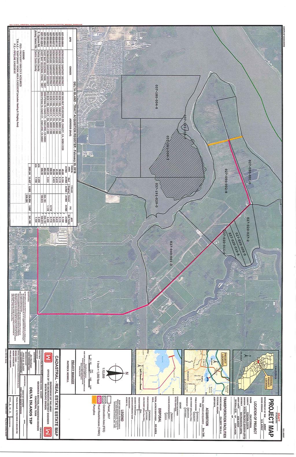
10 11. Project Map 9
11 12. Anticipated Increased Flooding and Impacts Hydraulic modeling and analysis show that the new intertidal marsh lands to be created by the project would not increase flooding risks and instead would tend to reduce the velocity of water flowing through the Big Break area. 13. Cost Estimate for Necessary Real Property Rights A preliminary estimate of the costs of acquiring LERRDs necessary to support the project s Tentatively Selected Plan was prepared to assist in the calculation of a cost-benefit analysis for the purpose of quantifying the federal interest in the proposed Delta Islands project. The cost estimate meets the intent of Real Estate Policy Guidance Letter (PGL) No. 31, Real Estate Support to Civil Works Planning Paradigm (3x3x3), which requires a less formal estimation of the cost of acquiring real property rights when these costs are expected to represent a small component of overall project costs. The PGL directs that For projects in which the value of real estate (lands, improvements, and severance damages) are not expected to exceed ten percent of total project costs (total cost to implement project), a cost estimate (or rough order of magnitude) will be acceptable for purposes of the feasibility phase. The table on the following page estimates the direct and administrative costs associated with acquiring real property interests necessary to construct, operate and maintain the proposed project. This estimate was prepared on March 16, If the project s selected plan receives headquarters endorsement at the scheduled Agency Decision Milestone (ADM) meeting, real property acquisition costs will be updated thereafter to reflect current price levels. See page 12, below. 10
12 Table 2- Real Estate Cost Estimate Project Features Cost Contingency Total Costs Rounded Code of Accounts 01 FEDERAL Fed RE Admin labor $99, NON FEDERAL Lands and damages Account 01 $544,000 Non RE Fed Admin to Manage Leases and acquire rights/permits $420,000 5% 4,970 $104,370 5% $27,200 $571,200 5% $21,000 $441,000 Total LERRD s $1,116, Relocation Assistance Benefits Not Applicable. Project area consists of shallow open water and open marsh or agricultural lands; no relocations will be necessary. 15. Mineral / Timber Activity A prior grantor, Porter Estate Company Oakley Ranch, Inc., retains a perpetual right to enter the subsurface of the project s 340 acre marsh restoration area (at Parcel Nos and ) below a depth of 250 feet from the surface... to mine, excavate, drill, whip stock, explore, text, collect, produce and distribute any oil, petroleum, natural gas, hydrocarbons or other minerals found therein. But the mineral deed holder retains no right of surface entry, nor any right to enter within 250 feet of the surface. Because no interference with the project would arise in the event the mineral rights holder were to exercise its subterranean rights, no subordination of its real property interest is needed. No timber is present within the project footprint. 11
13 16. Non-Federal Sponsor s Ability to Acquire The non-federal sponsor possesses experienced real estate staff members capable of drafting real property instruments and professionally managing the acquisition of the real interests needed for the Delta Islands project. As an agency of the State of California the non-federal sponsor also possesses condemnation authority. 17. Zoning Anticipated in Lieu of Acquisition There is not an application or enactment of new zoning ordinances proposed in lieu of, or to facilitate, acquisition in connection with the project nor are such actions anticipated. 18. Acquisition Schedule The non-federal sponsor will be directed to begin real property acquisition for the Project only after a PPA is fully executed. A risk letter will be sent from the Corps to the State of California alerting the State, as non-federal Sponsor, to the risks associated with purchasing project lands or obtaining easements, servitudes or rights-of-way in advance of the execution of a PPA. The project s proposed period of construction extends through ten annual dredging cycles, with an anticipated placement of 100,000 cubic yards of dredged material within the project area each year. Thus the construction phase of the project is expected to extend to ten or more years. 12
14 REAL ESTATE ACQUISITION SCHEDULE Project Name: Delta Islands and Levees COE Start Receipt of preliminary drawings from Engineering/PM Receipt of final drawings from Engineering/PM COE Finish NFS Start NFS Finish Execution of PPA/Finalize Chief s Report October 2020 Formal transmittal of final drawings & instructions to acquire LERRDs Prepare/review mapping & legal descriptions Obtain/review title evidence Obtain/review tract appraisals Conduct negotiations Certify all necessary LERRDS are available for construction Prepare and submit credit requests Review/approve or deny credit requests Construction Duration Big Break material placement year 1 Big Break material placement year 2 Big Break material placement year 3 Big Break material placement year 4 Big Break material placement year 5 Big Break material placement year 6 Big Break material placement year 7 Big Break material placement year 8 Big Break material placement year 9 Big Break material placement year 10 Complete physical construction year 10 Complete plant establishment year 12 Complete project monitoring
15 19. Description of Facility and Utility Relocations No facility or utility relocations will be required for project construction. 20. Hazardous, Toxic, and Radiological Waste (HTRW) Naturally Occurring Hazards None are anticipated Hazards from Agricultural Practices None are anticipated. Hazards from Historical Mercury Mining None are anticipated Borrow Materials Historic chemical and granular test results of dredged materials from the Stockton Ship Channel at existing placement sites indicate that the dredged materials are chemically cleaner than the existing baseline sampling from the project area footprint. Future materials from dredging operations would be sampled prior to operations and maintenance dredging. Materials meeting baseline criteria would be utilized for marsh habitat creation. Materials not meeting baseline criteria would be conveyed to alternative disposal sites. Project construction activities are not expected to disturb existing HTRW sources that could lead to contamination of environmental resources. Therefore the tentatively selected plan is not expected to create any measurable HTRW effects. 21. Attitude of Landowners Letters have been sent to the East Bay Regional Park District and to the Ironhouse Sanitary District to introduce the project and to request cooperation in providing necessary real property rights for project construction and operation. Two recent meetings have occurred with the land owners and the East Bay Regional Park District has indicated that they are interested in being a second non-federal sponsor and are not only supportive of the project but have joined us to participate as a sponsor. In February 2013 when the project included flood risk features that were subsequently eliminated, two scoping meetings were held to educate the public about the study efforts and to request comments, in accordance with NEPA and CEQA. Results of these outreach efforts 14
16 were favorable. Numerous agencies, organizations, and individuals, including the U.S. Bureau of Reclamation, U.S. Fish and Wildlife Service, National Oceanic and Atmospheric Administration (NOAA Fisheries), U.S. Environmental Protection Agency, California Department of Fish and Wildlife, Sacramento County, San Joaquin County, Contra Costa County, Yolo County, Alameda County, Solano County, various levee maintenance agencies, local landowners and residents expressed support for marshland creation and habitat restoration in the area of the project site Exhibit A Follows
17 EXHIBIT A ASSESSMENT OF NON-FEDERAL SPONSOR'S REAL ESTATE ACQUISITION CAPABILITY DELTA ISLAND AND LEVEE FEASIBILITY STUDY SPONSORS: The State of California, Department of Water Resources I. Legal Authority: a. Do the sponsors have legal authority to acquire and hold title to real property for project purposes? Yes State of California, Department of Water Resources b. Do the sponsors have the power of eminent domain for this project? Yes State of California, Department of Water Resources; c. Do the sponsors have "quick-take" authority for this project? Yes State of California, Department of Water Resources d. Are any of the lands/interests in land required for the project located outside the sponsor's political boundary? No State of California, Department of Water Resources e. Are any of the lands/interests in land required for the project owned by an entity whose property the sponsor cannot condemn? No State of California, Department of Water Resources II. Human Resource Requirements: a. Will the sponsor's in-house staff require training to become familiar with the real estate requirements of Federal projects including P.L , as amended? Yes State of California, Department of Water Resources b. If the answer to a. is "yes," has a reasonable plan been developed to provide such training? Yes State of California, Department of Water Resources c. Does the sponsor's in-house staff have sufficient real estate acquisition experience to meet its responsibilities for the project? Yes State of California, Department of Water Resources d. Is the sponsor's project in-house staffing level sufficient considering its other workload, if any, and the project schedule? Yes State of California, Department of Water Resources e. Can the sponsor obtain contractor support, if required, in a timely fashion? Yes State of California, Department of Water Resources f. Will the sponsor likely request USACE assistance in acquiring real estate? No the State of California, Department of Water Resources is capable. 16
18 III. Other Project Variables: a. Will the sponsor's staff be located within reasonable proximity to the project site? Yes State of California, Department of Water Resources b. Has the sponsor approved the project real estate schedule/milestones? Response: No, the approval occurs during the preconstruction, engineering and design phase. IV. Overall Assessment: a. Has the sponsor performed satisfactorily on other USACE projects? Yes State of California, Department of Water Resources b. With regard to this project, the sponsor is anticipated to be: The State of California, Central Valley Flood Protection Board V. Coordination: a. Has this assessment been coordinated with the sponsor? Yes State of California, Department of Water Resources b. Does the sponsor concur with this assessment? Yes State of California, Department of Water Resources 17
19 EXHIBIT A ASSESSMENT OF NON-FEDERAL SPONSOR'S REAL ESTATE ACQUISITION CAPABILITY DELTA ISLAND AND LEVEE FEASIBILITY STUDY SPONSORS: East Bay Park Regional Park District I. Legal Authority: a. Do the sponsors have legal authority to acquire and hold title to real property for project purposes? Yes. Land Owner: East Bay Regional Park District. b. Do the sponsors have the power of eminent domain for this project? Yes-East Bay Regional Park District c. Do the sponsors have "quick-take" authority for this project? Yes East Bay Regional Park District d. Are any of the lands/interests in land required for the project located outside the sponsor's political boundary? No East Bay Regional Park District e. Are any of the lands/interests in land required for the project owned by an entity whose property the sponsor cannot condemn? No East Bay Regional Park District II. Human Resource Requirements: a. Will the sponsor's in-house staff require training to become familiar with the real estate requirements of Federal projects including P.L , as amended? Yes East Bay Regional Park District. b. If the answer to a. is "yes," has a reasonable plan been developed to provide such training? Yes - East Bay Regional Park District would rely on State of California, Department of Water Resources c. Does the sponsor's in-house staff have sufficient real estate acquisition experience to meet its responsibilities for the project? Yes East Bay Regional Park District. d. Is the sponsor's project in-house staffing level sufficient considering its other workload, if any, and the project schedule? Yes East Bay Regional Park District. e. Can the sponsor obtain contractor support, if required, in a timely fashion? Yes if through State of California, Department of Water Resources East Bay Regional Park District f. Will the sponsor likely request USACE assistance in acquiring real estate? No the State of California, Department of Water Resources is capable. 18
20
21
22
23
24
25
DRAFT INTEGRATED FEASIBILITY REPORT AND ENVIRONMENTAL ASSESSMENT
 APPENDIX E REAL ESTATE PLAN MT. SINAI MEDICAL CENTER, CONTINUTING AUTHORITIES PROGRAM (CAP) SECTION 14, PROJECT DRAFT INTEGRATED FEASIBILITY REPORT AND ENVIRONMENTAL ASSESSMENT September 2016 DRAFT APPENDIX
Draft Continuing Authorities Program Section 1135 Detailed Project Report and Integrated Environmental Assessment
 Appendix G Real Estate Shorty s Island / Meander Reach Ecosystem Restoration Kootenai River, Idaho Draft Continuing Authorities Program Section 1135 Detailed Project Report and Integrated Environmental
Appendix G. Non-Federal Letters of Support and Draft Real Estate Plan
 Appendix G Non-Federal Letters of Support and Draft Real Estate Plan REAL ESTATE PLAN UPPER DELAWARE RIVER WATERSHED FEASABILITY STUDY LIVINGSTON MANOR, NEW YORK 1. GENERAL 2. REAL ESTATE REQUIREMENTS
JANUARY 2016 MAMARONECK & SHELDRAKE RIVERS NEW YORK FLOOD RISK MANAGEMENT GENERAL REEVALUATION REPORT FOR THE VILLAGE OF MAMARONECK APPENDIX E
 U.S. Army Corps of Engineers New York District MAMARONECK & SHELDRAKE RIVERS NEW YORK FLOOD RISK MANAGEMENT GENERAL REEVALUATION REPORT FOR THE VILLAGE OF MAMARONECK JANUARY 2016 APPENDIX E REAL ESTATE
Appendix B Real Estate Plan
 Appendix B Real Estate Plan B-1 REAL ESTATE PLAN Prepared for U.S. Army Corps of Engineers Southwestern Division Little Rock District As of May 1, 2013 Prepared by Ronald Bridges Real Estate Division ANY
Appendix B Draft Real Estate Plan
 Appendix B Draft Real Estate Plan B-1 REAL ESTATE PLAN Prepared for U.S. Army Corps of Engineers Southwestern Division Little Rock District As of December 3, 2012 Prepared by Ronald Bridges Real Estate
Appendix C. Real Estate. Brazos Island Harbor, Texas Channel Improvement Project Cameron County, Texas
 Appendix C Real Estate Brazos Island Harbor, Texas Channel Improvement Project Cameron County, Texas U.S. Army Corps of Engineers, Galveston District 2000 Fort Point Road Galveston, Texas 77550 December
EDISTO BEACH COASTAL STORM DAMAGE REDUCTION GENERAL INVESTIGATION STUDY APPENDIX K REAL ESTATE
 EDISTO BEACH COASTAL STORM DAMAGE REDUCTION GENERAL INVESTIGATION STUDY APPENDIX K REAL ESTATE Table of Contents REAL ESTATE APPENDIX... I... i SECTION 1. THE REAL ESTATE REPORT... 1 1.1 Statement of Purpose...
Appendix H: Real Estate Plan
 APPENDIX H Spring Creek North Ecosystem Restoration Feasibility Study Appendix H: Real Estate Plan New York District U.S. Army Corps of Engineers October 2016 Revised: 13 April 2017 Spring Creek North
APPENDIX D - REAL ESTATE
 APPENDIX D - REAL ESTATE 1. Purpose Real Estate Plan For Feasibility Study For Lake Lou Yaeger Section 206 Aquatic Ecosystem Restoration Continuing Authorities Project Feasibility Study This report is
APPENDIX M. Real Estate Plan
 APPENDIX M Real Estate Plan Poplar Island Environmental Restoration Project September 2005 General Reevaluation Report (GRR) and Supplemental Environmental Impact Statement (SEIS) REAL ESTATE PLAN (REP)
INDIANA HARBOR AND CANAL CONFINED DISPOSAL FACILITY EAST CHICAGO, INDIANA
 INDIANA HARBOR AND CANAL CONFINED DISPOSAL FACILITY EAST CHICAGO, INDIANA APPENDIX J REAL ESTATE Acquisition Branch Real Estate Division Chicago District U.S. Army Corps of Engineers APPENDIX J REAL ESTATE
Delaware River Basin Comprehensive Flood Risk Management Interim Feasibility Study and Integrated Environmental Assessment for New Jersey
 Delaware River Basin Comprehensive Flood Risk Management Interim Feasibility Study and Integrated Environmental Assessment for New Jersey Flooding in the Study Area, April 2005 June 2015 APPENDIX F: Draft
Draft Integrated Feasibility Report and Environmental Assessment and Draft Finding of No Significant Impact
 Draft Integrated Feasibility Report and Environmental Assessment and Draft Finding of No Significant Impact APPENDIX F: REAL ESTATE Whittier, Alaska June 2018 Pacific Ocean Division DRAFT REAL ESTATE
Draft Environmental Impact Statement (EIS)/Environmental Impact Report (EIR) APPENDIX H Real Estate Cost
/Environmental Impact Report (EIR) APPENDIX H Real Estate Cost") Draft Environmental Impact Statement (EIS)/Environmental Impact Report (EIR) APPENDIX H Real Estate Cost US Army Corps of Engineers Corte Madera Creek Flood Risk Management Project October 2018 APPENDIX
Draft Environmental Impact Statement (EIS)/Environmental Impact Report (EIR) APPENDIX H Real Estate Cost US Army Corps of Engineers Corte Madera Creek Flood Risk Management Project October 2018 APPENDIX
WEST SHORE LAKE PONTCHARTRAIN HURRICANE AND STORM DAMAGE RISK REDUCTION STUDY INTEGRATED DRAFT FEASIBILITY REPORT AND ENVIRONMENTAL IMPACT STATEMENT
 WEST SHORE LAKE PONTCHARTRAIN HURRICANE AND STORM DAMAGE RISK REDUCTION STUDY INTEGRATED DRAFT FEASIBILITY REPORT AND ENVIRONMENTAL IMPACT STATEMENT REAL ESTATE PLAN APPENDIX C Annex A: Project Maps Annex
APPENDIX F REAL ESTATE
 APPENDIX F REAL ESTATE Real Estate Plan For Broward County, Florida Shore Protection Project Segments II and III General Reevaluation Report 1. Statement Of Purpose. The Real Estate Plan is tentative in
HASHAMOMUCK COVE, SOUTHOLD, NEW YORK COASTAL STORM RISK MANAGEMENT FEASIBILITY STUDY APPENDIX F REAL ESTATE PLAN
 U.S. Army Corps of Engineers New York District HASHAMOMUCK COVE, SOUTHOLD, NEW YORK COASTAL STORM RISK MANAGEMENT FEASIBILITY STUDY APPENDIX F REAL ESTATE PLAN AUGUST 2016 HASHAMOMUCK COVE, SOUTHOLD, NEW
REAL ESTATE PLAN APPENDIX G
 Pacific Ocean Division REAL ESTATE PLAN APPENDIX G Alaska District UNALASKA (DUTCH HARBOR) CHANNELS UNALASKA, ALASKA Real Estate Division Alaska District U.S. Army Corps of Engineers TABLE OF CONTENTS
APPENDIX E REAL ESTATE PLAN
 APPENDIX E REAL ESTATE PLAN REAL ESTATE PLAN VILLAGE OF BARBOURSVILLE, WATER STREET, STREAMBANK PROTECTION PROJECT CABELL COUNTY, WEST VIRGINIA SECTION 14 1. Authority/Purpose This Real Estate Plan is
APPENDIX G REAL ESTATE
 BUBBLY CREEK, SOUTH BRANCH OF THE CHICAGO RIVER, ILLINOIS FEASIBILITY STUDY APPENDIX G REAL ESTATE DRAFT - NOT FOR DISTRIBUTION APRIL 2015 U.S. Army Corps of Engineers Chicago District Appendix G Real
Draft Appendix E. Real Estate Plan. Rahway River Basin, New Jersey Flood Risk Management Feasibility Study. November 2016
 Draft Appendix E Real Estate Plan Rahway River Basin, New Jersey Flood Risk Management Feasibility Study November 2016 New Jersey Department of Environmental Protection U.S. Army Corps of Engineers New
DRAFT REAL ESTATE PLAN APPENDIX D JEFFERSON COUNTY ECOSYSTEM RESTORATION FEASIBILITY STUDY
 DRAFT REAL ESTATE PLAN APPENDIX D JEFFERSON COUNTY ECOSYSTEM RESTORATION FEASIBILITY STUDY (NOTE: This page intentionally left blank.) This Real Estate Plan has been prepared in accordance with ER 405-1-12
DEPARTMENT OF THE ARMY OFFICE OF THE CHIEF OF ENGINEERS WASHINGTON, D.C
 DEPARTMENT OF THE ARMY OFFICE OF THE CHIEF OF ENGINEERS WASHINGTON, D.C. 20314-1000 REPLY TO ATTENTION OF: CECW-PM (10-1-7a) THE SECRETARY OF THE ARMY 1. I submit for transmission to Congress my report
APPENDIX C REAL ESTATE PLAN BOULEVARD RESACA, BROWNSVILLE, TX CAMERON COUNTY, TEXAS
 APPENDIX C REAL ESTATE PLAN BOULEVARD RESACA, BROWNSVILLE, TX CAMERON COUNTY, TEXAS November 19, 2016 Table of Contents Purpose... 3 Project Authority... 3 Project Location and Description... 3 Non-Federal
MAMARONECK AND SHELDRAKE RIVER FLOOD DAMAGE REDUCTION PROJECT MAMARONECK, NEW YORK APPENDIX E REAL ESTATE PLAN
 U.S. Army Corps of Engineers New York District MAMARONECK AND SHELDRAKE RIVER FLOOD DAMAGE REDUCTION PROJECT MAMARONECK, NEW YORK APPENDIX E REAL ESTATE PLAN April 2017 MAMARONECK AND SHELDRAKE RIVER FLOOD
APPENDIX F REAL ESTATE PLAN. Redwood City Harbor Navigation Improvement Feasibility Study, Redwood City, California
 APPENDIX F REAL ESTATE PLAN Redwood City Harbor Navigation Improvement Feasibility Study, Redwood City, California PREPARED FOR THE SAN FRANCISCO DISTRICT SOUTH PACIFIC DIVISION 20 April 2015 PREPARED
Skagit River Flood Risk Management General Investigation Skagit County, Washington. Draft Feasibility Report and Environmental Impact Statement
 General Investigation Skagit County, Washington Draft Feasibility Report and Environmental Impact Statement May 2014 Real Estate Requirements of Selected Plan This Real Estate Plan Summary (REP) is presented
Dredged Material Management Plan Atlantic Intracoastal Waterway Port Royal Sound, South Carolina to Cumberland Sound, Georgia November 2015
 Dredged Material Management Plan Atlantic Intracoastal Waterway Port Royal Sound, South Carolina to Cumberland Sound, Georgia November 2015 Appendix H: Real Estate US Army Corps of Engineers South Atlantic
DRAFT East Rockaway Inlet to Rockaway Inlet and Jamaica Bay. Atlantic Coast of New York
 DRAFT East Rockaway Inlet to Rockaway Inlet and Jamaica Bay Atlantic Coast of New York APPENDIX E REAL ESTATE PLAN AUGUST 2018 East Rockaway Inlet to Rockaway Inlet and Jamaica Bay Reformulation Study
UPPER MISSISSIPPI RIVER RESTORATION FEASIBILITY REPORT WITH INTEGRATED ENVIRONMENTAL ASSESSMENT
 UPPER MISSISSIPPI RIVER RESTORATION FEASIBILITY REPORT WITH INTEGRATED ENVIRONMENTAL ASSESSMENT McGregor Lake HABITAT REHABILITATION AND ENHANCEMENT PROJECT POOL 10, UPPER MISSISSIPPI RIVER MILE 635-634
APPENDIX H. Real Estate Plan
 INTEGRATED FEASIBILITY REPORT AND ENVIRONMENTAL IMPACT STATEMENT COASTAL STORM DAMAGE REDUCTION BOGUE BANKS, CARTERET COUNTY NORTH CAROLINA APPENDIX H Real Estate Plan US Army Corps of Engineers Wilmington
DEPARTMENT OF THE ARMY OFFICE OF THE CHIEF OF ENGINEERS WASHINGTON. D.C MAR
 DEPARTMENT OF THE ARMY OFFICE OF THE CHIEF OF ENGINEERS WASHINGTON. D.C. 2031 4-1 000 MAR 3 1 2006 CEMP-NAD (1 0-1-7a) THE SECRETARY OF THE ARMY 1. I submit for transmission to Congress my report on the
APPENDIX H REAL ESTATE REQUIREMENTS
 Malden River Ecosystem Restoration Detailed Project Report APPENDIX H REAL ESTATE REQUIREMENTS April 2007 Malden River Ecosystem Restoration Real Estate Report 1. PURPOSE: The Detailed Project Report
Appendix J. Real Estate Plan
 Appendix J Real Estate Plan Real Estate Plan Louisiana Coastal Area Near-Term Ecosystem Restoration Plan Medium Diversion at White Ditch 1. PURPOSE Title VII of the Water Resources Development Act of 2007
AGREEMENT TO ACQUIRE LANDS BETWEEN THE DEPARTMENT OF THE ARMY ST. PAUL DISTRICT, CORPS OF ENGINEERS AND. THE CITY OF City, State
 AGREEMENT TO ACQUIRE LANDS BETWEEN THE DEPARTMENT OF THE ARMY ST. PAUL DISTRICT, CORPS OF ENGINEERS AND THE CITY OF City, State FOR CONDEMNATION ON BEHALF OF THE SPONSOR BY THE CORPS OF ENGINEERS FOR THE
HUNTING BAYOU FLOOD RISK MANAGEMENT, HARRIS COUNTY, TEXAS DRAFT GENERAL REEVALUATION REPORT AND INTEGRATED ENVIRONMENTAL ASSESSMENT
 HUNTING BAYOU FLOOD RISK MANAGEMENT, HARRIS COUNTY, TEXAS DRAFT GENERAL REEVALUATION REPORT AND INTEGRATED ENVIRONMENTAL ASSESSMENT APPENDIX 6 REAL ESTATE PLAN June 2014 HARRIS COUNTY FLOOD CONTROL DISTRICT
DWR REAL ESTATE COORDINATION PLAN
 DWR REAL ESTATE COORDINATION PLAN Exhibit E DWR PROPERTY ACQUISTION PLAN EXHIBIT E Revised Date: 5 10 18 DWR PROPERTY ACQUISTION PLAN EXHIBIT E Revised Date: 5-10-2018 California WaterFix Real Estate Coordination
Final General Reevaluation Report and Final Environmental Impact Statement. Hurricane Protection and Beach Erosion Control
 Final General Reevaluation Report and Final Environmental Impact Statement on Hurricane Protection and Beach Erosion Control WEST ONSLOW BEACH AND NEW RIVER INLET (TOPSAIL BEACH), NORTH CAROLINA Appendix
Submittal of the Minutes from the March 9, 2011, April 5, 2011, and April 19, 2011 Cabinet Meetings.
 AGENDA BOARD OF TRUSTEES OF THE INTERNAL IMPROVEMENT TRUST FUND JUNE 16, 2011 Attachments to the items below can be viewed at the following link: http://www.dep.state.fl.us/secretary/cab/public_notices.htm
Appendix D: Real Estate
 Shrewsbury River Basin, Sea Bright, New Jersey Coastal Storm Risk Management Feasibility Study Draft Integrated Feasibility Report & Environmental Assessment Appendix D: Real Estate Shrewsbury River Basin,
BEACH STORM DAMAGE REDUCTION EASEMENT
 STATE OF FLORIDA COUNTY OF WALTON WALTON COUNTY, FL HURRICANE & STORM DAMAGE REDUCTION PROJECT FILE/REACH#: PARCEL ID#: BEACH STORM DAMAGE REDUCTION EASEMENT KNOW ALL MEN BY THESE PRESENTS, that for and
APPENDIX D REAL ESTATE PLAN
 APPENDIX D REAL ESTATE PLAN APPENDIX D REAL ESTATE PLAN TABLE OF CONTENTS 1. STATEMENT OF PURPOSE 2. REFERENCES 3. AUTHORIZATION 4. BACKGROUND 5. LOCATION 6. REAL ESTATE REQUIREMENTS 7. OWNERSHIP OF REAL
Appendix D Real Estate Plan
 Appendix D Real Estate Plan Matagorda Ship Channel, Port Lavaca, Texas Feasibility Report and Environmental Impact Statement, Review of Completed Projects, Calhoun and Matagorda Counties May 2018 (NOTE:
UPPER MISSISSIPPI RIVER RESTORATION FEASIBILITY REPORT WITH INTEGRATED ENVIRONMENTAL ASSESSMENT
 UPPER MISSISSIPPI RIVER RESTORATION FEASIBILITY REPORT WITH INTEGRATED ENVIRONMENTAL ASSESSMENT BEAVER ISLAND HABITAT REHABILITATION AND ENHANCEMENT PROJECT POOL 14, UPPER MISSISSIPPI RIVER MILES 513.0-517.0
Corte Madera Marsh Restoration Project Update
 Corte Madera Marsh Restoration Project Update Building and Operating Committee Agenda Item No. 5 August 25, 2016 Photo credit: WRA Background of Site 1. 72 acre parcel carved out of larger property acquired
CITY OF FORT COLLINS NATURAL AREAS AND CONSERVED LANDS EASEMENT POLICY
 CITY OF FORT COLLINS NATURAL AREAS AND CONSERVED LANDS EASEMENT POLICY Adopted January 3, 2012 PURPOSE: The purpose of the policy statement is to clarify the policies and procedures of the City of Fort
REAL ESTATE PLAN. Final Integrated General Reevaluation Report and Supplemental Environmental Impact Statement
 REAL ESTATE PLAN Final Integrated General Reevaluation Report and Supplemental Environmental Impact Statement Mississippi River, Baton Rouge to the Gulf of Mexico Mississippi River-Gulf Outlet, Louisiana,
Southwest Coastal Louisiana Study
 REAL ESTATE PLAN Annex 1: Project Maps Annex 2: Assessment of Non-Federal Sponsor s Acquisition Capability Annex 3: Non-Material Deviation from Standard Estate Perpetual Access Easement Annex 4: Baseline
Mississippi River Ship Channel Gulf to Baton Rouge, LA Integrated General Reevaluation Report And Supplemental Environmental Impact Statement
 APPENDIX B Real Estate Plan B-1.0 PROJECT PURPOSE, DESCRIPTION, LOCATION AND DESCRIPTION OF THE LANDS, EASEMENTS, RIGHTS-OF-WAY, RELOCATIONS AND DISPOSAL (LERRD) REQUIRED The purpose of this Real Estate
CURRENT THROUGH PL , APPROVED 11/11/2009
 CURRENT THROUGH PL 111-98, APPROVED 11/11/2009 TITLE 10. ARMED FORCES SUBTITLE A. GENERAL MILITARY LAW PART IV. SERVICE, SUPPLY, AND PROCUREMENT CHAPTER 159. REAL PROPERTY; RELATED PERSONAL PROPERTY; AND
Federal Mandates and Willing Sellers: Real Estate Acquisition for the Missouri River Recovery Program
 Federal Mandates and Willing Sellers: Real Estate Acquisition for the Missouri River Recovery Program Brad Thompson, Chief, Civil Works Branch U.S. Corps of Engineers, Omaha District US Army Corps of Engineers
Downtown Montauk Stabilization Project. Real Estate Plan Appendix
 Downtown Montauk Stabilization Project Real Estate Plan Appendix October 2014 Table of Contents Page 1. Introduction and General Information 1 a. Authority 2 b. History 2 c. Location Project Study Area
Chapter 10 Local Protection Measures
 The DPC fully supports the protection of private property rights and the DPC will work to ensure that there will be no negative impacts stemming from NHA activities on private property, should the designation
Application Procedures for Easements or Rights of Way on City of Fort Collins Natural Areas and Conserved Lands March 2012
 Application Procedures for Easements or Rights of Way on City of Fort Collins Natural Areas and Conserved Lands March 2012 IMPORTANT NOTE: This document was created to accompany the City of Fort Collins
THIS DECLARATION OF RESTRICTIVE COVENANTS is made this day of, 20, by ("Covenantor"). RECITALS
. RECITALS") Model for Use with Permits Without Mitigation Plans STATE OF COUNTY OF DECLARATION OF RESTRICTIVE COVENANTS THIS DECLARATION OF RESTRICTIVE COVENANTS is made this day of, 20, by ("Covenantor"). RECITALS
Model for Use with Permits Without Mitigation Plans STATE OF COUNTY OF DECLARATION OF RESTRICTIVE COVENANTS THIS DECLARATION OF RESTRICTIVE COVENANTS is made this day of, 20, by ("Covenantor"). RECITALS
CONSERVATION AND PRESERVATION EASEMENTS ACT Act of Jun. 22, 2001, P.L. 390, No. 29 AN ACT Providing for the creation, conveyance, acceptance,
 CONSERVATION AND PRESERVATION EASEMENTS ACT Act of Jun. 22, 2001, P.L. 390, No. 29 AN ACT Cl. 68 Providing for the creation, conveyance, acceptance, duration and validity of conservation and preservation
PUGET SOUND NEARSHORE ECOSYSTEM RESTORATION
 PUGET SOUND NEARSHORE ECOSYSTEM RESTORATION APPENDIX C REAL ESTATE PLAN Integrated Feasibility Report and Environmental Impact Statement This page was intentionally left blank to facilitate double sided
DECLARATION OF RESTRICTIVE COVENANTS. THIS DECLARATION OF RESTRICTIVE COVENANTS made this day of, 200_, by ( Declarant ). RECITALS
. RECITALS") DECLARATION OF RESTRICTIVE COVENANTS THIS DECLARATION OF RESTRICTIVE COVENANTS made this day of, 200_, by ( Declarant ). RECITALS WHEREAS, Declarant is the owner of the surface of certain real property
DECLARATION OF RESTRICTIVE COVENANTS THIS DECLARATION OF RESTRICTIVE COVENANTS made this day of, 200_, by ( Declarant ). RECITALS WHEREAS, Declarant is the owner of the surface of certain real property
EXHIBIT A ENVIRONMENTAL COVENANT AND ACCESS AGREEMENT
 ENVIRONMENTAL COVENANT AND ACCESS AGREEMENT AFTER RECORDING RETURN TO: Laura Wishik, Esq. Director, Environmental Protection Section P. O. Box 94769 Seattle, WA 98124-4769 GRANTOR AND OWNER: City of Seattle
IMPLEMENTING AGREEMENT. for the EAST CONTRA COSTA COUNTY HABITAT CONSERVATION PLAN/ NATURAL COMMUNITY CONSERVATION PLAN.
 IMPLEMENTING AGREEMENT for the EAST CONTRA COSTA COUNTY HABITAT CONSERVATION PLAN/ NATURAL COMMUNITY CONSERVATION PLAN by and between EAST CONTRA COSTA COUNTY HABITAT CONSERVANCY, COUNTY OF CONTRA COSTA,
Evaluating and Processing Road and Utility Easement Proposals on Corps Lands and Flowage Easements
 Evaluating and Processing Road and Utility Easement Proposals on Corps Lands and Flowage Easements Don Wiese Natural Resources Manager Fort Worth District September 13, 2017 US Army Corps of Engineers
DEPARTMENT OF THE ARMY U.S. Army Corps of Engineers Washington, DC Regulation No May 2015
 CEMP-CR DEPARTMENT OF THE ARMY U.S. Army Corps of Engineers Washington, DC 20314-1000 ER 405-1-19 Regulation No. 405-1-19 29 May 2015 Real Estate ACQUISITION BY CONDEMNATION PROCEEDINGS 1. Purpose. Engineer
Chapter HABITAT CONSERVATION PLAN / NATURAL COMMUNITY CONSERVATION PLAN IMPLEMENTATION ORDINANCE
 Chapter 15.108 HABITAT CONSERVATION PLAN / NATURAL COMMUNITY CONSERVATION PLAN IMPLEMENTATION ORDINANCE Sections: 15.108.010 Purpose. 15.108.020 Definitions. 15.108.030 Applicability 15.108.040 Responsibility
GENERAL RE-EVALUATION REPORT APPENDIX B: REAL ESTATE SAVANNAH HARBOR EXPANSION PROJECT Chatham County, Georgia and Jasper County, South Carolina
 GENERAL RE-EVALUATION REPORT APPENDIX B: REAL ESTATE SAVANNAH HARBOR EXPANSION PROJECT Chatham County, Georgia and Jasper County, South Carolina January 2012 (Revised July 2012) US Army Corps of Engineers
MODEL DEED RESTRICTION FOR THE PENNSYLVANIA STATE PROGRAMMATIC GENERAL PERMIT-3 (PASPGP-3) DECLARATION OF RESTRICTIVE COVENANTS FOR CONSERVATION
 DECLARATION OF RESTRICTIVE COVENANTS FOR CONSERVATION") MODEL DEED RESTRICTION FOR THE PENNSYLVANIA STATE PROGRAMMATIC GENERAL PERMIT-3 (PASPGP-3) DECLARATION OF RESTRICTIVE COVENANTS FOR CONSERVATION THIS DECLARATION OF RESTRICTIVE COVENANTS FOR CONSERVATION
MODEL DEED RESTRICTION FOR THE PENNSYLVANIA STATE PROGRAMMATIC GENERAL PERMIT-3 (PASPGP-3) DECLARATION OF RESTRICTIVE COVENANTS FOR CONSERVATION THIS DECLARATION OF RESTRICTIVE COVENANTS FOR CONSERVATION
DECLARATION OF RESTRICTIVE COVENANTS
 DECLARATION OF RESTRICTIVE COVENANTS The Declarant,, is the fee simple owner of the certain real property located in County, Kansas, as described on Exhibit A, which is attached hereto and incorporated
Conservation Easement Stewardship
 Conservation Easements are effective tools to preserve significant natural, historical or cultural resources. Conservation Easement Stewardship Level of Service Standards March 2013 The mission of the
CONSERVATION EASEMENT INCLUDING MITIGATION
 After recording return to: GRANTOR: GRANTEE: GRANTEE (Trustee): LEGAL DESCRIPTION: TAX PARCEL I.D. #: REFERENCE # s: WHATCOM COUNTY N/A CONSERVATION EASEMENT INCLUDING MITIGATION This grant of a conservation
CENAN-RE 22 May MEMORANDUM FOR Chief, Planning Division, ATTN: CENAN-PL-F (Alek Petersen)
") CENAN-RE 22 May 2017 MEMORANDUM FOR Chief, Planning Division, ATTN: CENAN-PL-F (Alek Petersen) SUBJECT: May 2017 Real Estate Plan for the Rahway River (Tidal) Basin, Coastal Storm Risk Management Feasibility
CENAN-RE 22 May 2017 MEMORANDUM FOR Chief, Planning Division, ATTN: CENAN-PL-F (Alek Petersen) SUBJECT: May 2017 Real Estate Plan for the Rahway River (Tidal) Basin, Coastal Storm Risk Management Feasibility
APPENDIX H REAL ESTATE PLAN
 APPENDIX H REAL ESTATE PLAN This page intentionally left blank. APPENDIX H REAL ESTATE PLAN DALLAS FLOODWAY FEASIBILITY STUDY DATE OF REPORT January 31, 2014 PREPARED BY REAL ESTATE DIVISION U.S. ARMY
Land Management Plan Fargo-Moorhead (FM) Area Flood Risk Reduction Project Version 1
 Area Flood Risk Reduction Project Version 1") Land Management Plan Fargo-Moorhead (FM) Area Flood Risk Reduction Project Version 1 Prepared for Fargo-Moorhead Area Flood Diversion Board of Authority July 12, 2012 REV 1 Contents Section Page Acronyms
Land Management Plan Fargo-Moorhead (FM) Area Flood Risk Reduction Project Version 1 Prepared for Fargo-Moorhead Area Flood Diversion Board of Authority July 12, 2012 REV 1 Contents Section Page Acronyms
City of East Providence
 City of East Providence 145 TAUNTON AVENUE, EAST PROVIDENCE STATE OF RHODE ISLAND AND PROVIDENCE PLANTATIONS 02914-4505 TEL. (401) 435-7521 FAX (401) 438-1719 TDD (401) 431-1633 CITY MANAGER PETER GRACZYKOWSKI
Marin County Agricultural Land Conservation Program March 1, 2014
 Marin County Agricultural Land Conservation Program March 1, 2014 I. Purpose of this Document This document describes the Marin County Agricultural Land Conservation Program (County Program). The Marin
U.S. Army Corps of Engineers Charleston District APPENDIX E CHARLESTON HARBOR POST 45 CHARLESTON, SOUTH CAROLINA. Real Estate
 U.S. Army Corps of Engineers Charleston District APPENDIX E CHARLESTON HARBOR POST 45 CHARLESTON, SOUTH CAROLINA Real Estate May 2015 Table of Contents REAL ESTATE APPENDIX E... I... i... i SECTION 1.
Appendix A. Definitions
 Definitions 1. Terms Defined. Words contained in this are those having a special meaning relative to the purposes of this Ordinance. Words not listed in this section shall be defined by reference to: (1)
Remains eligible for state or federal farm programs. Can use land as collateral for loans. Can reserve home lots for children
 December 2002 B-1132 Conservation Easements: An Introductory Review for Wyoming By Allison Perrigo and Jon Iversen, William D. Ruckelshaus Institute of Environment and Natural Resources William D. Ruckelshaus
Stormwater Ordinance Appendix APPENDIX K EXAMPLE TAR-PAM CONVERSATION EASEMENT
 APPENDIX K EXAMPLE TAR-PAM CONVERSATION EASEMENT Tax Parcel ID # NORTH CAROLINA FRANKLIN COUNTY CONSERVATION EASEMENT Franklin County, North Carolina THIS CONSERVATION EASEMENT (this "Conservation Easement")
It is necessary for the Board to adopt the attached resolution accepting the dedication of the easement.
 SOUTHAMPTON COUNTY BOARD OF SUPERVISORS Regular Session i May 28, 2013 11. ACCEPTANCE OF A SANITARY SEWER EASEMENT FROM THE COMMONWEALTH OF VIRGINIA, DEPARTMENT OF TRANSPORTATION Attached for your review
PROJECT SCORING GUIDANCE. Introduction: National Proiect Selection:
 FOREST LEGACY PROGRAM PROJECT SCORING GUIDANCE Introduction: This document provides guidance to the National Review Panel on how to score individual Forest Legacy Program (FLP) projects, including additional
DRAFT REAL ESTATE PLAN APPENDIX C GULF INTRACOASTAL WATERWAY BRAZOS RIVER FLOODGATES AND COLORADO RIVER LOCKS SYSTEMS FEASIBILITY STUDY
 DRAFT REAL ESTATE PLAN APPENDIX C GULF INTRACOASTAL WATERWAY BRAZOS RIVER FLOODGATES AND COLORADO RIVER LOCKS SYSTEMS FEASIBILITY STUDY This Real Estate Plan has been prepared in accordance with ER 405-1-12
Texas Land Trust Conference March 6, 2015
 Texas Land Trust Conference March 6, 2015 James D. Bradbury James D. Bradbury, PLLC Austin Fort Worth An Overview Unique area of law where the government can take private property Protected by the US Constitution
FOREST SERVICE HANDBOOK NATIONAL HEADQUARTERS (WO) WASHINGTON, DC
 WASHINGTON, DC") Page 1 of 58 FOREST SERVICE HANDBOOK NATIONAL HEADQUARTERS (WO) WASHINGTON, DC Amendment No.: 5409.13-2004-1 Effective Date: February 27, 2004 Duration: This amendment is effective until superseded or
Page 1 of 58 FOREST SERVICE HANDBOOK NATIONAL HEADQUARTERS (WO) WASHINGTON, DC Amendment No.: 5409.13-2004-1 Effective Date: February 27, 2004 Duration: This amendment is effective until superseded or
ATTACHMENT 4 CERCLA NOTICE, COVENANT, AND ACCESS PROVISIONS AND OTHER DEED PROVISIONS
 ATTACHMENT 4 CERCLA NOTICE, COVENANT, AND ACCESS PROVISIONS AND OTHER DEED PROVISIONS CERCLA NOTICE, COVENANT, AND ACCESS PROVISIONS AND OTHER DEED PROVISIONS The following CERCLA Notice, Covenant, and
Central Pennsylvania Conservancy Project Selection Criteria Form
 Central Pennsylvania Conservancy Project Selection Criteria Form The following criteria guide the actions of the Central Pennsylvania Conservancy s Land Protection Committee and Board of Directors in selecting
RESOLUTION NUMBER 2017-
 RESOLUTION NUMBER 2017- RESOLUTION BY THE CITY COUNCIL OF THE CITY OF ORLANDO, FLORIDA, DETERMINING THE NECESSITY OF ACQUIRING CERTAIN REAL PROPERTY ALONG BOGGY CREEK ROAD FOR THE PURPOSE OF CONSTRUCTING
Tejon Ranch Conservation and Land Use Agreement Executive Summary
 Tejon Ranch Conservation and Land Use Agreement Executive Summary The Tejon Ranch Company (TRC) and Audubon California, the Endangered Habitats League, Natural Resources Defense Council, Planning and Conservation
Town of Jupiter Island Delegated Mangrove Authority For the State of Florida
 Town of Jupiter Island Delegated Mangrove Authority For the State of Florida Mangroves are regulated by the State of Florida. The Town of Jupiter Island is a delegated regulatory agency for the State for
Yolo Habitat Conservancy County of Yolo City of Davis City of Winters City of West Sacramento City of Woodland University of California, Davis
 Yolo Habitat Conservancy County of Yolo City of Davis City of Winters City of West Sacramento City of Woodland University of California, Davis Science & Technical Advisory Committee (STAC) Operational
REGENTS POLICY PART V FINANCE AND BUSINESS MANAGEMENT Chapter Real Property
 REGENTS POLICY PART V FINANCE AND BUSINESS MANAGEMENT Chapter 05.11 Real Property P05.11.010. Purpose and Scope. A. This chapter establishes guidelines for the prudent management, including trust management,
CHAPTER House Bill No. 733
 CHAPTER 2004-410 House Bill No. 733 An act relating to the Loxahatchee Groves Water Control District, Palm Beach County; amending chapter 99-425, Laws of Florida; amending the district s election procedures;
Napa County Planning Commission Board Agenda Letter
 Agenda Date: 9/20/2017 Agenda Placement: 8C Napa County Planning Commission Board Agenda Letter TO: FROM: Napa County Planning Commission Charlene Gallina for David Morrison - Director Planning, Building
43 USC NB: This unofficial compilation of the U.S. Code is current as of Jan. 4, 2012 (see
 TITLE 43 - PUBLIC LANDS CHAPTER 35 - FEDERAL LAND POLICY AND MANAGEMENT SUBCHAPTER II - LAND USE PLANNING AND LAND ACQUISITION AND DISPOSITION 1716. Exchanges of public lands or interests therein within
Form of Easement and Right of Way Agreement For Gas Pipeline
 Form of Easement and Right of Way Agreement For Gas Pipeline This Easement and Right of Way Agreement ( Easement ) is entered by and between, with an address of ( Grantor ) and with an address of ( Grantee
ORDINANCE NO The Board of Supervisors of the County of San Joaquin ordains as follows:
 ORDINANCE NO. 4308 AN ORDINANCE ADDING CHAPTER 9-1080 OF DIVISION 10 OF TITLE 9 OF THE ORDINANCE CODE OF SAN JOAQUIN COUNTY PERTAINING TO AGRICULTURAL MITIGATION. The Board of Supervisors of the County
DEED OF AGRICULTURAL CONSERVATION EASEMENT TO THE COMMONWEALTH OF PENNSYLVANIA IN PERPETUITY
 Prepared By: Return To: UPI# DPERSF (6-2006) EXHIBIT C DEED OF AGRICULTURAL CONSERVATION EASEMENT TO THE COMMONWEALTH OF PENNSYLVANIA IN PERPETUITY THIS DEED OF AGRICULTURAL CONSERVATION EASEMENT, made
Central Lathrop Specific Plan
 Addendum to the Draft Environmental Impact Report for the Central Lathrop Specific Plan SCH# 2003072132 Prepared for City of Lathrop Prepared by December 2005 Addendum to the Draft Environmental Impact
Public Notice U.S. ARMY CORPS OF ENGINEERS, GALVESTON DISTRICT AND TEXAS COMMISSION ON ENVIRONMENTAL QUALITY
 Public Notice U.S. Army Corps Permit Application No: SWG-2016-00384 Of Engineers Date Issued: 27 December 2018 Galveston District Comments Due: 29 January 2019 U.S. ARMY CORPS OF ENGINEERS, GALVESTON DISTRICT
A Minor Land Excavation Operating Permit is used to:
 CHAPTER 400. SECTION 404. PERMIT TYPES AND APPLICATIONS OPERATING PERMITS 404.1. Minor Land Excavation A. Intent and Purpose The intent and purpose of this section is to protect the public health, safety,
JOINT PUBLIC NOTICE CORPS OF ENGINEERS STATE OF ARKANSAS Application Number: Date: December 9, 2016 Comments Due: January 3, 2017
 US Army Corps of Engineers Little Rock District JOINT PUBLIC NOTICE CORPS OF ENGINEERS STATE OF ARKANSAS Application Number: 2016-00183-1 Date: December 9, 2016 Comments Due: January 3, 2017 TO WHOM IT