REAL ESTATE PLAN APPENDIX G
|
|
|
- Marshall Miles
- 5 years ago
- Views:
Transcription

1 Pacific Ocean Division REAL ESTATE PLAN APPENDIX G Alaska District KENAI BLUFFS BANK STABILIZATION SECTION 116 FEASIBILITY STUDY KENAI, ALASKA Real Estate Branch Alaska District U.S. Army Corps of Engineers
2 TABLE OF CONTENTS ITEM PAGE PURPOSE:... 1 PROJECT TYPE AND APPLICABILITY:... 1 PROJECT SCOPE AND CONTENT:... 2 ALTERNATIVES CONSIDERED IN DETAIL... 2 Alternative 1: No Action... 2 Alternative 2: Rive Mouth Relocation... 3 Alternative 3: Revetting and Vegetating the Bluff Face Buried Toe... 4 Alternative 5: Protective Berm at the Bluff Toe... 6 Alternative 6: Non-Structural Plan Description of Lands, Easements, Right-of-way, Relocation and Disposals (LERRD):... 7 TABLE 1A: Alternative 2 LERRD Requirements... 8 TABLE 1B: Alternative 3 and 4 LERRD Requirements... 8 TABLE 1C: Alternative 5 LERRD Requirements... 8 TABLE 1D: Alternative 6 LERRD Requirements... 9 PROJECT COMPONENTS:... 9 STANDARD ESTATES:... 9 NON-STANDARD ESTATES:... 9 FEDERAL LANDS:... 9 NEAREST OTHER EXISTING FEDERAL PROJECT:... 9 NAVIGATION SERVITUDE:... 9 INDUCED FLOODING:... 9 BASELINE COST ESTIMATE FOR REAL ESTATE... 9 TABLE 2A - Alternative 2 Baseline Cost Estate for Real Estate TABLE 2B Alternatives 3 and 4 Baseline Cost Estate for Real Estate: TABLE 2C - Alternative 5 Baseline Cost Estate for Real Estate: TABLE 2D: - Alternative 6 Baseline Cost Estate for Real Estate UTILITIES & FACILITIES RELOCATIONS: RELOCATION ASSISTANCE BENEFITS: HTRW IMPACTS:... 12
3 MINERAL/TIMBER ACTIVITY: REAL ESTATE MAP: SPONSORSHIP CAPABILITY: NOTIFICATION OF SPONSOR AS TO PRE-PCA LAND ACQUISITION: ZONING ORDINANCES ENACTED: SCHEDULE: VIEWS OF FEDERAL, STATE, AND REGIONAL AGENCIES VIEWS OF LOCAL RESIDENTS: ANY OTHER RELEVANT REAL ESTATE ISSUES: EXHIBITS: Assessment of Sponsor Real Estate Acquisition Capabilities Exhibit A Real Estate Ownership Map for Alternative Exhibit B-1 Real Estate Ownership Map for Alternative 3 & Exhibit B-2 Real Estate Ownership Map for Alternative Exhibit B-3 Real Estate Ownership Map for Alternative Exhibit B-4 ii
4 KENAI BLUFFS BANK STABILIZATION SECTION 116 FEASIBILITY STUDY KENAI, ALASKA REAL ESTATE PLAN PURPOSE: The purpose of the feasibility study is to evaluate potential solutions to erosion problems at the Kenai Bluff. The bluff is approximately 100 feet in height, fronts the northern bank of the Kenai River where it empties into Cook Inlet. Storm surges and wind-driven waves attack the toe of the bluff during storm events, causing erosion. In addition, groundwater seepage through the bluff and overland flow exacerbates the erosion problem. This Real Estate Plan (REP) will be consolidated into the decision document. The REP identifies and describes the real estate requirements for the lands, easements, rights-of-way, relocations and disposal areas (LERRD) that will be required. The REP is tentative in nature; it is for planning purposes only and both the final real property acquisition lines and the real estate cost estimates provided are subject to change even after approval of the Feasibility Report. PROJECT TYPE AND APPLICABILITY: This feasibility study is being conducted under authority granted by a resolution adopted on December 2, 1970, by the Committee on Public Works of the U.S. House of Representatives. The resolution states: And Resolved by the Committee on Public Works of the House of Representatives, United States, that the Board of Engineers for rivers and Harbors is hereby requested to review the reports of the Chief of Engineers on Rivers and Harbors in Alaska, published as House Document Numbered 414, 83 rd Congress, 2 nd Session; and other pertinent reports, with a view to determine whether any modifications of the recommendations contained therein are advisable at the present time. Section 116 of the Energy and Water Development Appropriations Act of 2010 (P.L , Title I) as amended for the prevention and reduction of storm damage, coastal erosion, and ice and glacial damage, as well as the relocation of communities and construction of replacement facilities for relocated communities. Nonfederal Sponsor for the project is the. Past action related to the Kenai River bluff erosion include: Resolution of House Committee on Public Works, 2 Dec 70; Review reports on Rivers and Harbors in Alaska. Energy and Water Development Appropriations Act, 2002, Senate Committee 1

5 Report, page 27. Kenai River Bluff Erosion, AK. The Committee has provided $500,000 for a special technical evaluation study of bank stabilization needs along the Lower Kenai River. PROJECT SCOPE AND CONTENT: The KENAI BLUFFS BANK STABILIZATION SECTION 116 FEASIBILITY STUDY involves the development of alternatives to: a. Reduce or prevent further erosion at the toe of the bluff. b. To reduce or prevent sediment transport through the bluff as a result of groundwater seepage. c. To reduce or prevent erosion at the top of the bluff due to overland flow. Lower Kenai River, Kenai, Alaska Vicinity Map ALTERNATIVES CONSIDERED IN DETAIL Five alternative were evaluated along with a no action alternatives. Alternative 1: No Action This alternative would leave the community with a bluff that will continue to erode. Land 2

6 will continue to be lost and no long term plans could be made for development along the bluff. Alternative 2: Rive Mouth Relocation This alternative consists of excavating a new 1,000 foot wide river channel to -10 feet MLLW approximately 5,800 feet into Cook Inlet and maintaining the channel opening with the construction of two jetties. The existing river mouth would be closed by an approximately 4,300 foot cut-off dike that would be constructed from the jetty to the bluff. Construction of the dike would be necessary to prevent removal of the eroded bluff material by wave action during high tide and surge events. The owns the channel. Dredging would be needed, but is not authorized by the current authorization. 3

7 RIVER MOUTH RELOCATION ALTERNATIVE DREDGED CHANNEL Alternative 3: Revetting and Vegetating the Bluff Face Buried Toe This alternative would entail cutting and filling the bluff to a more stable slope, construction of a stone revetment at the base of the bluff, and vegetating the unreveted bluff slope. Construction of a stable slope would balance the cut and fill areas along the bluff by cutting the top of the bluff back and using the excavated material as fill along the toe of the bluff. The toe of the slope would be protected by a rock revetment. A filter fabric would separate the filter rock from the material below. This alternative will require of fee interest in property. Mitigation of archaeological and historical assets could be quite costly as well. This plan would not address the loss of economic activity at these sites. The real estate requirements and real estate cost are the same as Alternative 4. 4

8 Alternative 4: Revetting and Vegetating the Bluff Face Weighted Toe This alternative would reduce the volume of material cut from the bluff and use fill at the base to create a more stable slope. A stone revetment would be constructed at the base of the fill area. Slopes not protected by the revetment would be vegetated. Filter fabric would separate the filter rock from the native material. The toe of the revetment would be constructed to launch material placed on the river side of the revetment to fill potential scour holes. The real estate requirements and real estate cost are the same as Alternatives 3. 5

9 Alternative 5: Protective Berm at the Bluff Toe This alternative would allow the bluff to reach a stable slope naturally by constructing a berm at the base of the bluff. The bluff would be allowed to naturally recede. Material lost from the bluff face would be protected from being washed away by the river and allowed to build up behind the berm. There would be no cutting or filling of the bluff face and no real estate acquisition will be required north of the purpose berm. It is anticipated that the bluff will eventually lay back to a 2H:1V stable slope. The berm was located to provide storage of the bluff face material laid back on a 2H:1V slope. The river side toe of the berm would be built up to provide launch material to fill potential scour holes. 6

: The project is located within the, on the western coast of the Kenai Peninsula, fronting Cook Inlet.")
10 Alternative 6: Non-Structural Plan - The Non-Structural Alternative provides a temporary solution to an ongoing long term issue. The future economic impact is not consider here. The Non-Federal Sponsor will acquire all property within the 50 year Erosion area. The Non-Federal Sponsor is required to comply with P.L businesses or residential relocation assistance benefits required for this project. Description of Lands, Easements, Right-of-way, Relocation and Disposals (LERRD): The project is located within the, on the western coast of the Kenai Peninsula, fronting Cook Inlet. It is approximately 65 air miles and 155 highway miles southwest of Anchorage. LERRD necessary to implement this project includes feesimple lands already own by the NFS, temporary work area easement, temporary or permanent road easements, and bank protection easements. The NFS owns the tides and submerged lands lying within Alaska Tideland Survey 272. No staging or disposal areas have been identified. 7
11 TABLE 1A: Alternative 2 LERRD Requirements FEATURES OWNERS ACRES INTEREST REQUIRED Channel with 2 jetties 4 parcels Fee Dike TOTAL PROJECT BOUNARY ac 4 parcels 4 parcels privately owned Fee TABLE 1B: Alternative 3 and 4 LERRD Requirements FEATURES OWNERS ACRES INTEREST REQUIRED Revetment 11 parcels, 33 parcels, Privately owned Fee Construction Area 5 parcels, 14 parcels, Privately owned Temp Work Area Easement for 3 years or until completion TOTAL PROJECT BOUNARY ac TABLE 1C: Alternative 5 LERRD Requirements FEATURES OWNERS ACRES INTEREST REQUIRED Construction Boundary 8 parcels, 20 parcels, privately owned Temp Work Area Easement for 3 years or until completion Protective Berm (included in Construction Boundary 7 parcels, 11 parcel(s, privately owned Bank Protection Easement TOTAL PROJECT BOUNARY ac 8
12 TABLE 1D: Alternative 6 LERRD Requirements FEATURES OWNERS ACRES INTEREST REQUIRED Purchase Land and Improvements TOTAL PROJECT BOUNARY 39 ac 14 parcels, 44 parcels, Privately owned Fee PROJECT COMPONENTS: See Baseline Cost Estimate Section STANDARD ESTATES: Fee Simple (Alternatives 2, 3, 4. & 6) Temporary Work Area Easement (Alternatives 3, 4, & 5) Bank Protection Easement (Alternative 5) NON-STANDARD ESTATES: None FEDERAL LANDS: None NEAREST OTHER EXISTING FEDERAL PROJECT: There are no other existing Federal Projects that will be affected by the project footprint. NAVIGATION SERVITUDE: Navigation servitude is not applicable. The NFS owns the tide lands located within ATS 272. INDUCED FLOODING: Flooding is not expected as a result of the project. BASELINE COST ESTIMATE FOR REAL ESTATE The NFS will negotiate to secure real estate interest in the privately owned lands for the project (See Exhibits B1 B4 - Real Estate Map). The NFS will acquire all necessary real estate interest in the lands necessary for the project. The is a home rule charter municipality and is subjected to taxation. The estimate of the Fair Market Value (FMV) was provided by Les Crane, Land Appraiser, Kenai Peninsula Borough. The real property price estimates are based on borough tax assessment times a factor of Values in the Baseline Cost Estimate are estimates and not a final LERRD value for crediting purposes. 9
13 TABLE 2A - Alternative 2 Baseline Cost Estate for Real Estate Item # of Units Unit Cost Total Cost Remarks Acquire properties 12 Fair Market Value $982,355 Appraisals 3 $15,000 $45,000 Appraisals Reviews 3 $5,000 $15,000 City Administrative Costs 2000 $125 $250,000 USACE Admin Cost 500 $125 $62,500 Baseline Cost Estimate for RE $1,354,855 TABLE 2B Alternatives 3 and 4 Baseline Cost Estate for Real Estate: The Non-Federal Sponsor is required to comply with P.L businesses or residential relocation assistance benefits required for this project. Alternatives 3 and 4 are based on the following assumptions; The layback line was provided by CEPOA-EC-G-HH. Possible relocation of an estimated 52 private residents, Possible relocation of an estimated 8 businesses, Possible relocation of an estimated 0.50 miles of all utilities within the erosion zone. Item # of Units Unit Cost Total Cost Remarks Acquire properties 55 Fair Market AcquFee and $4,556,748 Value Easement Estate Resident Relocation 52 $25000 $1,300,000 Business Relocation 8 $250,000 $2,000,000 Utilities Relocation 0.75 miles Appraisals 32 $15,000 $480,000 Appraisals Reviews 32 $5,000 $160,000 City Administrative 7000 Costs $125 $875,000 USACE Admin Cost 1500 $125 $187,500 Baseline Cost Estimate for RE $12,059,248 TABLE 2C - Alternative 5 Baseline Cost Estate for Real Estate: Alternative 5 is based on the following assumptions; The natural layback line was established by CEPOA-EC-G-HH and the lands south of the natural layback line and north of the construction boundary of the berm structure are not a part of the project and no relocations are required. 10
14 Item # of Units Unit Cost Total Cost Remarks Acquire properties 28 Fair Market Value $879,034 Appraisals 10 $15, $150,000 Appraisals Reviews 10 $5, $50,000 City Administrative Costs 2500 $ $312,500 USACE Admin Cost 1000 $ $125,000 Baseline Cost Estimate for RE $1,516,534 TABLE 2D: - Alternative 6 Baseline Cost Estate for Real Estate The Non-Federal Sponsor is required to comply with P.L businesses or residential relocation assistance benefits required for this project Item # of Units Acquire properties 58 Unit Cost Total Cost Remarks Fair Market Value 11 $17,323,737 Resident Relocation* 86 $25, $2,150,000 Business Relocation* 8 $250, $2,000,000 Utilities Relocation $2,500, miles Appraisals 39 $15, $585,000 Appraisals Reviews 39 $5, $195,000 City Administrative Costs 7000 $ $875,000 USACE Admin Cost 1500 $ $187,500 Baseline Cost Estimate for RE $25,816,237 UTILITIES & FACILITIES RELOCATIONS: a. For Alternatives 2 and 5 there are no known utilities or facilities that require relocation. b. For Alternatives 3, 4, and 6; power, gas and water utilities may be abandoned in place. Discussion will be held with the utilities owners after the alternative has been selected. RELOCATION ASSISTANCE BENEFITS: There are no P.L businesses or residential relocation assistance benefits required for this Alternatives 2 and 5.
15 HTRW IMPACTS: There are no known information pertaining to hazardous, toxic and radioactive wastes or materials, within the project footprint was provided. MINERAL/TIMBER ACTIVITY: For Alternatives 3 and 4 there may have timber activity within Lots and For Alternatives, 2, 5 and 6, there are no current or anticipated mineral or timber activities within the vicinity of the proposed project that will affect construction, operation, or maintenance of the proposed project. Nor will any subsurface minerals or timber harvesting take place within the project. REAL ESTATE MAP: The Real Estate Map will be produced by POA, in collaboration with the. SPONSORSHIP CAPABILITY: The is a fully capable sponsor for acquiring the required lands, easements, and rights-of-way (See Exhibit A - Sponsor Real Estate Acquisition Capability Assessment). The Sponsor has professional experienced staff and legal capability to provide all lands, easements, and rights-of-way required for project purposes. The city has been advised of P.L requirements; and they have been advised of the requirements for documenting expenses for LERRD crediting purposes. The Sponsor s point of contact information is: Sean Wedemeyer Public Works Director Capital Project Manager 210 Fidalgo Avenue Kenai, Alaska swedemeyer@kenai.city NOTIFICATION OF SPONSOR AS TO PRE-PCA LAND ACQUISITION: The non-federal sponsor has been notified in writing about the risks associated with acquiring land before the execution of the PCA and the Government s formal notice to proceed with acquisition. ZONING ORDINANCES ENACTED: No zoning ordinances are proposed in lieu of, or to facilitate acquisition in connection with the project, but if the project is approved the City would consider legislation/zoning changes at that time. SCHEDULE: The anticipated project schedule, unless revised after coordination with NFS, as shown in Table 3. 12
16 Table 3: Project Schedule TASK START NFS - RECEIPT OF FINAL DRAWINGS FROM COE ENGINEERING COE - FORMAL TRANSMISSION OF ROW DRAWINGS & INSTRUCTIONS TO ACQUIRE LERRD NFS - CERTIFY ALL NECESSARY LERRD AVAILABLE FOR CONSTRUCTION NFS - PREPARE & SUBMIT CREDIT REQUESTS COE - REVIEW/APPROVE OR DENY CREDIT REQUESTS 2-4 weeks after PPA execution 4-6 weeks after PPA execution 6-9 months after PPA execution 6-8 months upon completion of Project 6 months of Sponsor submission VIEWS OF FEDERAL, STATE, AND REGIONAL AGENCIES This project is supported by Federal, State, and Regional agencies. The Corps has met with representatives of the and other pertinent parties to discuss aspects of the proposed action. Further coordination will be ongoing. In compliance with NEPA letters will be sent to resource agencies and residents in the area. he Integrated Feasibility Report/Environmental Assessment will be made available for public review under a public notice. VIEWS OF LOCAL RESIDENTS: The has conducted public meetings concerning this project. Local residents are in favor of the project with funding remaining an issue to be resolved. Further coordination will be ongoing between the, US Army Corps of Engineers, State and Federal resource agencies, and residents in the area. ANY OTHER RELEVANT REAL ESTATE ISSUES: Previous baseline real estate cost estimate for Alternative 6, Non Structural- Relocation real estate included cost of construction of new residents. IAW Federal Regulations Implementing the Uniform Relocation Assistance and Real Property Acquisition Policies Act of 1970, as amended, the current baseline real estate cost estimates does not included the cost of construction for willing sellers. We have made the following assumptions; the property owners are willing sellers and would accept a fair market value offer. The historic site relocation/documentation and historic site evaluation cost was not included, it will be provided by the Archaeologist to be included in a separate appendix. PREPARED BY: REVIEWED AND APPROVED BY: RONALD J GREEN Realty Specialist 13 MICHAEL D COY Chief, Real Estate 23 March 2017
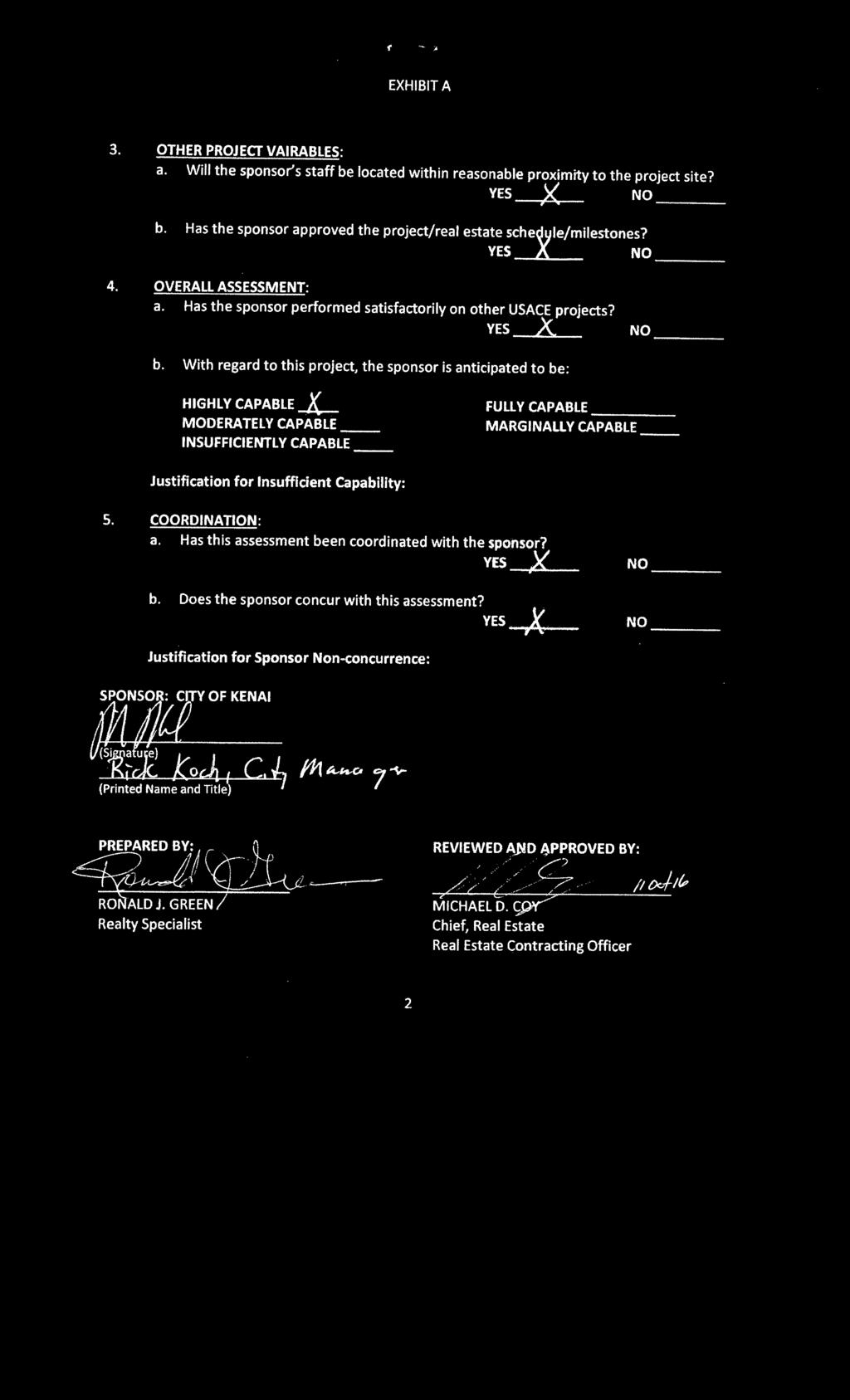
17 EXHIBIT A ASSESSMENT OF NON-FEDERAL SPONSOR'S REAL ESTATE ACQUISITION CAPABILITY KENAI BLUFFS BANK STABILIZATION KENAI, ALASKA 1. LEGAL AUTHORITY: a. Does the sponsor have legal authority to acquire and hold title to real property for project purposes? YES )( NO > ---- b. Does the sponsor have the power of eminent domain for this project? YES X NO c. Does the sponsor have "Quick-Take" authority for this project? YES x NO d. Are any of the lands/interests in land required for this project located outsid~e sponsor's political boundary? YES NO _~A e. Are any of the lands/interests in land required for this project owned by an entity whose property the sponsor cannot condemn? YES NO )< 2. HUMAN RESOURCE REQUIREMENTS: a. Will the sponsor's in-house staff require training to become familiar with the real estate requirements of Federal projects including P.l , as amended? YES NO X b. If the answer to 2a is "YES" has a reasonable plan been developed to provide such training? YES NO c. Does the sponsor's in-house staff have sufficient real estate acquisition experience to meet its responsibilities for the project? YEs_X. NO ---- d. Is the sponsor's projected in-house staffing level sufficient considering its other work load, if any, and the project schedule? YES X NO e. Can the sponsor obtain contractor support, if required in a timely fashion? YES x NO f. Will the sponsor likely request USACE assistance in acquiring real estate? X YES NO,,, 1

18

19 1 Tax Lot Acres Owner - Road Gerald E. Collins - River ATS Mew Trust Lowell M. Puckett, Trustee Kenai Bible Church - Road - Cook Inlet q T5N, R11W, SM 1, T5N, R12W, SM T5N, R11W, SM 0 FEATURE Channel Channel Channel Channel Dike Dike Dike Dike Dike Dike Dike Dike Dike Jettie/Dike 6 1,000 Feet Legend 7 mv_borough_kenai_py ALT2 RE Requirements FEATURE Channel Dike Jettie/Dike 3/23/2017 DATE DESCRIPTION DATE REVISION APPVD BY Updated Real Estate map to indentify the LER required for the project and estabish tract numbers.the property data was provided by the Kenai Peninsula Borough. Borough. DESCRIPTION BY 8 APPVD EXHIBIT B-1: ALTERNATIVE 2, River Mouth Relocation Feasibility REVISION q KENAI # I SUBMITTED: U.S. ARMY CORPS OF ENGINEERS REAL ESTATE BRANCH RECOMMENDED: REAL-ESTATE SECTION APPROVED: CHIEF, REAL-ESTATE SECTION Document Path: O:\RE\Private\01 RE CONSOLIDATED FILES\Kenai\Kenai Bluff Stabilization\FINAL REP \KENAI_BLUFF_REP_LAYOUT alt2.mxd DRAWN BY: RJG CHECKED BY: PLOTTED BY: DISCLAIMER Access Constraints: The United States Government furnishes these data and the recipient accepts and uses them with the express understanding that the US Government makes no warranties, expressed, or implied concerning the accuracy, completeness, readability, usability or suitability for any particular purpose of the information and the data furnished. The United States Government shall be under no liability whatsoever to any person by reason of any use made thereof. These data belong to the US Government. Therefore the recipient fully agrees not to represent these data to anyone as other than US Government provided data. The recipient may not transfer these data to others without also transferring this Disclaimer. Distribution Liability: This data represents the results of data collection/processing for a specific US Army Corps of Engineers activity and indicates the general existing conditions. As such, it is only valid for its intended use, content, time and accuracy specifications. The user is responsible for the results of any of the application of the data for other than its intended purpose. US Army Corps of Engineers PROPERTY OWNER/LOCATION NOTES Coordinate System: NAD 1983 StatePlane Alaska 4 FIPS 5004 Feet Projection: Transverse Mercator Datum: North American 1983 False Easting: 1,640, False Northing: Central Meridian: Scale Factor: Latitude Of Origin: Units: Foot US ALASKA DISTRICT FROM: TO: KENAI BLUFFS BANK STABILIZATION SEC 116 FEASIBILITY STUDY

20 Tax_Lot Area FEE ESTATE Owner - Road - River Diocese of Sitka & Alaska Orthodox Church RABUF LLC Robert L Peters & Patricia M Peters Mary Ann Alfano Aaronson Daniel Jennifer F Yeoman Kenai Joes Alaskan Roadhouse Company Robert E & Lee Imelda c & Maria T Mercado Kenai Bible Church Michael & Linda Dunn Inlet View Apartments LLC Mrs Honaker's LLC Mrs Honaker's LLC Brenda Trefon Area TEMPORARY WORK AREA EASEMENT Tax_Lot Text Owner - Road David & Michael Schilling Diocese of Sitka & Alaska Orthodox Church Robert L Peters & Patricia M Peters Kenai Bible Church Mary Ann Alfano Kenai Bible Church Lowell M. Puckett, Trustee Mew Trust Jennifer F Yeoman Julie Latta Robert E Lee & Imelda Lee & Maria T. Merc Patricia Bushman-Sprague Jerry Sprague 20 Diana Lofstedt Julian Errea & Dan L. Hildebrand McCann Estate BIlly, Sterling Glenda A Russell S. Clark Michael & Linda Dunn Diana Lofstedt Patricia A. Bushman & Jerry R. Sprague Alaska Laborers Building Corp Lary and Carol Marsh Mrs Honaker's LLC Estate of Clarence E. LeDoux, Sr. Brenda Trefon Linda Cannizzo Victor Wisel Hannah Properties LLC Jeffrey C Pfile Lancet Ann Boyer Trust, James Johnson Re Sands BB Testamentary Trust Dorothy M. Cooper Vann Revocable Trust Crystal Consiel & Paul P. Karaffa q Legend Layback Line # I US Army Corps of Engineers ALASKA DISTRICT CHIEF, REAL-ESTATE SECTION T6N, R11W, SM T5N, R11W, SM Temporary Work Area Easement Fee Estate Document Path: O:\RE\Private\01 RE CONSOLIDATED FILES\Kenai\Kenai Bluff Stabilization\Maps and Surveys\KENAI_BLUFF_REP_LAYOUT _alt34.mxd Distribution Liability: This data represents the results of data collection/processing for a specific US Army Corps of Engineers activity and indicates the general existing conditions. As such, it is only valid for its intended use, content, time and accuracy specifications. The user is responsible for the results of any of the application of the data for other than its intended purpose. APPROVED: PROPERTY OWNER/LOCATION DISCLAIMER DRAWN BY: FROM: TO: EXHIBIT B-2: " ALTERNATIVE 3: Revetting and Vegetating the Bluff Face - Buried Toe ALTERNATIVE 4: Revetting and Vegatating the Bluff Face - Weighted Toe REAL ESTATE BRANCH CHECKED BY: RECOMMENDED: PLOTTED BY: REAL-ESTATE SECTION RJG Access Constraints: The United States Government furnishes these data and the recipient accepts and uses them with the express understanding that the US Government makes no warranties, expressed, or implied concerning the accuracy, completeness, readability, usability or suitability for any particular purpose of the information and the data furnished. The United States Government shall be under no liability whatsoever to any person by reason of any use made thereof. These data belong to the US Government. Therefore the recipient fully agrees not to represent these data to anyone as other than US Government provided data. The recipient may not transfer these data to others without also transferring this Disclaimer. U.S. ARMY CORPS OF ENGINEERS NOTES SUBMITTED: Coordinate System: NAD 1983 StatePlane Alaska 4 FIPS 5004 Feet Projection: Transverse Mercator Datum: North American 1983 False Easting: 1,640, False Northing: Central Meridian: Scale Factor: Latitude Of Origin: Units: Foot US KENAI BLUFFS BANK STABILIZATION SEC 116 FEASIBILITY STUDY
21 REVISION DATE DESCRIPTION BY APPVD REVISION DATE DESCRIPTION BY APPVD q KENAI US Army Corps of Engineers ALASKA DISTRICT DISCLAIMER U.S. ARMY CORPS OF ENGINEERS NOTES KENAI BLUFFS BANK STABILIZATION SEC 116 FEASIBILITY STUDY Access Constraints: The United States Government furnishes these data and the recipient accepts and uses them with the express understanding that the US Government makes no warranties, expressed, or implied concerning the accuracy, completeness, readability, usability or suitability for any particular purpose of the information and the data furnished. The United States Government shall be under no liability whatsoever to any person by reason of any use made thereof. These data belong to the US Government. Therefore the recipient fully agrees not to represent these data to anyone as other than US Government provided data. The recipient may not transfer these data to others without also transferring this Disclaimer. DRAWN BY: SUBMITTED: RJG REAL ESTATE BRANCH CHECKED BY: RECOMMENDED: Distribution Liability: This data represents the results of data collection/processing for a specific US Army Corps of Engineers activity and indicates the general existing conditions. As such, it is only valid for its intended use, content, time and accuracy specifications. The user is responsible for the results of any of the application of the data for other than its intended purpose. REAL-ESTATE SECTION PLOTTED BY: APPROVED: Coordinate System: NAD 1983 StatePlane Alaska 4 FIPS 5004 Feet Projection: Transverse Mercator Datum: North American 1983 False Easting: 1,640, False Northing: Central Meridian: Scale Factor: Latitude Of Origin: Units: Foot US PROPERTY OWNER/LOCATION CHIEF, REAL-ESTATE SECTION Document Path: O:\RE\Private\01 RE CONSOLIDATED FILES\Kenai\Kenai Bluff Stabilization\1KENAI PROPERTY DATA \FINAL DOCUMENTS\KENAI_BLUFF_REP_LAYOUT Alt5.mxd 6 TRACT REGISTER - CONTRUCTION BOUNDARY/TEMP EASEMENT Tax_Lot Acres Owner Estate Required Temporary Work Area Easement ATS Temporary Work Area Easement Temporary Work Area Easement Temporary Work Area Easement Temporary Work Area Easement Pacific Star Seafood, Inc 15 Temporary Work Area Easement Temporary Work Area Easement Kenai Bible Church 15 Temporary Work Area Easement Temporary Work Area Easement Lowell M. Puckett, Trustee 15 Temporary Work Area Easement Mew Trust 15 Temporary Work Area Easement Julie Latta 15 Temporary Work Area Easement Patricia Bushman-Sprague Jerry Sprague 2012Trust 15 Temporary Work Area Easement Temporary Work Area Easement Diana Lofstedt 15 Temporary Work Area Easement Julian Errea & Dan L. Hildebrand 15 Temporary Work Area Easement McCann Estate BIlly, Sterling Glenda A 15 Temporary Work Area Easement Russell S. Clark 15 Temporary Work Area Easement Michael & Linda Dunn 15 Temporary Work Area Easement Diana Lofstedt 15 Temporary Work Area Easement Patricia A. Bushman & Jerry R. Sprague 15 Temporary Work Area Easement Mrs Honaker's LLC 15 Temporary Work Area Easement Estate of Clarence E. LeDoux, Sr. 15 Temporary Work Area Easement Lancet Ann Boyer Trust, James Johnson Revo Trust 15 Temporary Work Area Easement Sands BB Testamentary Trust 15 Temporary Work Area Easement Dorothy M. Cooper 15 Temporary Work Area Easement Vann Revocable Trust 15 Temporary Work Area Easement Crystal Consiel & Paul P. Karaffa 15 Temporary Work Area Easement Natural Layback Line West Legend TRACT REGISTER - REQUIRED FOR CONSTRUCTION OF BERM Tax_Lot Area Owner Minimum Estate Required 0.21 Road 21 Bank Protection Easement ATS Bank Protection Easement Bank Protection Easement Bank Protection Easement Bank Protection Easement Kenai Bible Church 21 Bank Protection Easement Bank Protection Easement Lowell M. Puckett, Trustee 21 Bank Protection Easement Julie Latta 21 Bank Protection Easement Patricia Bushman-Sprague, Jerry Sprag 21 Bank Protection Easement Bank Protection Easement McCann Estate Billy, Sterling Glenda A. 21 Bank Protection Easement Russell S. Clark 21 Bank Protection Easement Michael & Linda Dunn 21 Bank Protection Easement Patricia A. Bushman & Jerry R. Spragu 21 Bank Protection Easement Estate of Clarence E. LeDoux, Sr. 21 Bank Protection Easement Crystal Consiel & Paul P. Karaffa 21 Bank Protection Easement Crystal Consiel & Paul P. Karaffa 21 Bank Protection Easement NATURAL LAYBACK LINE CONSTRUCTION BOUNDARY PROPERTY REQUIRED Estate Required 15 Temporary Work Area Easement PUBLIC ACCESS ROAD 21 Bank Protection Easement 21 Bank Protection Easement Natural Layback Line East p Feet T5N, R11W, SM The naturally according layback line, construction boundary and protective berm locations were provided by CEPOA-EC-G-HH EXHIBIT B-3: ALTERNATIVE 5, Protective Berm at the Bluff Toe Feasibility 3/22/2017 Updated Real Estate map to indentify the LER required for the project. The property data was provided by the Kenai Peninsula Borough.
22 KENAI q T5N, R11W, SM US Army Corps of Engineers ALASKA DISTRICT DISCLAIMER U.S. ARMY CORPS OF ENGINEERS NOTES KENAI BLUFFS BANK STABILIZATION SEC 116 FEASIBILITY STUDY Access Constraints: The United States Government furnishes these data and the recipient accepts and uses them with the express understanding that the US Government makes no warranties, expressed, or implied concerning the accuracy, completeness, readability, usability or suitability for any particular purpose of the information and the data furnished. The United States Government shall be under no liability whatsoever to any person by reason of any use made thereof. These data belong to the US Government. Therefore the recipient fully agrees not to represent these data to anyone as other than US Government provided data. The recipient may not transfer these data to others without also transferring this Disclaimer. DRAWN BY: SUBMITTED: RJG REAL ESTATE BRANCH CHECKED BY: RECOMMENDED: Distribution Liability: This data represents the results of data collection/processing for a specific US Army Corps of Engineers activity and indicates the general existing conditions. As such, it is only valid for its intended use, content, time and accuracy specifications. The user is responsible for the results of any of the application of the data for other than its intended purpose. REAL-ESTATE SECTION PLOTTED BY: APPROVED: Coordinate System: NAD 1983 StatePlane Alaska 4 FIPS 5004 Feet Projection: Transverse Mercator Datum: North American 1983 False Easting: 1,640, False Northing: Central Meridian: Scale Factor: Latitude Of Origin: Units: Foot US FROM: TO: PROPERTY OWNER/LOCATION CHIEF, REAL-ESTATE SECTION Document Path: O:\RE\Private\01 RE CONSOLIDATED FILES\Kenai\Kenai Bluff Stabilization\FINAL REP \KENAI_BLUFF_REP_LAYOUT _alt6.mxd Tax_Lot Owner Area Required (ac) SCHILLING DAVID & SCHILLING MICHA Robert L Peters & Patricia M Peters Kenai Bible Church Mary Ann Alfano Daniel Aaronson Kenai Bible Church Lowell M. Puckett, Trustee Mew Trust Jennifer F Yeoman KENAI JOES ALASKAN ROADHOUSE Aurora Investments Inc Julie Latta PENINSULA OILERS BASEBALL CLUB I MARIA T MERCADO LEE ROBERT E & LEE IMELDA C & ME Patricia Bushman-Sprague Jerry Sprague Diana Lofstedt Julian Errea & Dan L. Hildebrand McCann Estate BIlly, Sterling Glenda A Russell S. Clark Michael & Linda Dunn Kenai Bible Church Diana Lofstedt Patricia A. Bushman & Jerry R. Sprague Michael Abbott Anchorage Museum Foundation Inc Inlet View Apartments LLDC Mrs Honaker's LLC Mrs Honaker's LLC Alaska Laborers Building Corp Lary and Carol Marsh Mrs Honaker's LLC Estate of Clarence E. LeDoux, Sr Brenda Trefon Linda Cannizzo Victor Wisel Hannah Properties LLC Jeffrey C Pfile Vann Revocable Trust Lancet Ann Boyer Trust, James Johnson Sands BB Testamentary Trust Dorothy M. Cooper Vann Revocable Trust Crystal Consiel & Paul P. Karaffa Feet q Legend ALT16 3 FEET PER YEAR EROSION LINE ALT16 Improvements_Affected Alternative 6 Property to be Acquired Alternative 6 Property to be Acquired EXHIBIT B-4: Alternative 1: No Action Alternative 6: Non-structural The 3 feet per year erosion zone lines were provided by CEPOA-EC-G-HH
Draft Integrated Feasibility Report and Environmental Assessment and Draft Finding of No Significant Impact
 Draft Integrated Feasibility Report and Environmental Assessment and Draft Finding of No Significant Impact APPENDIX F: REAL ESTATE Whittier, Alaska June 2018 Pacific Ocean Division DRAFT REAL ESTATE
REAL ESTATE PLAN APPENDIX G
 Pacific Ocean Division REAL ESTATE PLAN APPENDIX G Alaska District UNALASKA (DUTCH HARBOR) CHANNELS UNALASKA, ALASKA Real Estate Division Alaska District U.S. Army Corps of Engineers TABLE OF CONTENTS
APPENDIX M. Real Estate Plan
 APPENDIX M Real Estate Plan Poplar Island Environmental Restoration Project September 2005 General Reevaluation Report (GRR) and Supplemental Environmental Impact Statement (SEIS) REAL ESTATE PLAN (REP)
Appendix G. Non-Federal Letters of Support and Draft Real Estate Plan
 Appendix G Non-Federal Letters of Support and Draft Real Estate Plan REAL ESTATE PLAN UPPER DELAWARE RIVER WATERSHED FEASABILITY STUDY LIVINGSTON MANOR, NEW YORK 1. GENERAL 2. REAL ESTATE REQUIREMENTS
JANUARY 2016 MAMARONECK & SHELDRAKE RIVERS NEW YORK FLOOD RISK MANAGEMENT GENERAL REEVALUATION REPORT FOR THE VILLAGE OF MAMARONECK APPENDIX E
 U.S. Army Corps of Engineers New York District MAMARONECK & SHELDRAKE RIVERS NEW YORK FLOOD RISK MANAGEMENT GENERAL REEVALUATION REPORT FOR THE VILLAGE OF MAMARONECK JANUARY 2016 APPENDIX E REAL ESTATE
APPENDIX D - REAL ESTATE
 APPENDIX D - REAL ESTATE 1. Purpose Real Estate Plan For Feasibility Study For Lake Lou Yaeger Section 206 Aquatic Ecosystem Restoration Continuing Authorities Project Feasibility Study This report is
Appendix H: Real Estate Plan
 APPENDIX H Spring Creek North Ecosystem Restoration Feasibility Study Appendix H: Real Estate Plan New York District U.S. Army Corps of Engineers October 2016 Revised: 13 April 2017 Spring Creek North
Appendix C. Real Estate. Brazos Island Harbor, Texas Channel Improvement Project Cameron County, Texas
 Appendix C Real Estate Brazos Island Harbor, Texas Channel Improvement Project Cameron County, Texas U.S. Army Corps of Engineers, Galveston District 2000 Fort Point Road Galveston, Texas 77550 December
DRAFT INTEGRATED FEASIBILITY REPORT AND ENVIRONMENTAL ASSESSMENT
 APPENDIX E REAL ESTATE PLAN MT. SINAI MEDICAL CENTER, CONTINUTING AUTHORITIES PROGRAM (CAP) SECTION 14, PROJECT DRAFT INTEGRATED FEASIBILITY REPORT AND ENVIRONMENTAL ASSESSMENT September 2016 DRAFT APPENDIX
EDISTO BEACH COASTAL STORM DAMAGE REDUCTION GENERAL INVESTIGATION STUDY APPENDIX K REAL ESTATE
 EDISTO BEACH COASTAL STORM DAMAGE REDUCTION GENERAL INVESTIGATION STUDY APPENDIX K REAL ESTATE Table of Contents REAL ESTATE APPENDIX... I... i SECTION 1. THE REAL ESTATE REPORT... 1 1.1 Statement of Purpose...
Appendix B Real Estate Plan
 Appendix B Real Estate Plan B-1 REAL ESTATE PLAN Prepared for U.S. Army Corps of Engineers Southwestern Division Little Rock District As of May 1, 2013 Prepared by Ronald Bridges Real Estate Division ANY
Appendix B Draft Real Estate Plan
 Appendix B Draft Real Estate Plan B-1 REAL ESTATE PLAN Prepared for U.S. Army Corps of Engineers Southwestern Division Little Rock District As of December 3, 2012 Prepared by Ronald Bridges Real Estate
APPENDIX C REAL ESTATE PLAN BOULEVARD RESACA, BROWNSVILLE, TX CAMERON COUNTY, TEXAS
 APPENDIX C REAL ESTATE PLAN BOULEVARD RESACA, BROWNSVILLE, TX CAMERON COUNTY, TEXAS November 19, 2016 Table of Contents Purpose... 3 Project Authority... 3 Project Location and Description... 3 Non-Federal
APPENDIX D REAL ESTATE PLAN
 APPENDIX D REAL ESTATE PLAN APPENDIX D REAL ESTATE PLAN TABLE OF CONTENTS 1. STATEMENT OF PURPOSE 2. REFERENCES 3. AUTHORIZATION 4. BACKGROUND 5. LOCATION 6. REAL ESTATE REQUIREMENTS 7. OWNERSHIP OF REAL
Draft Continuing Authorities Program Section 1135 Detailed Project Report and Integrated Environmental Assessment
 Appendix G Real Estate Shorty s Island / Meander Reach Ecosystem Restoration Kootenai River, Idaho Draft Continuing Authorities Program Section 1135 Detailed Project Report and Integrated Environmental
HASHAMOMUCK COVE, SOUTHOLD, NEW YORK COASTAL STORM RISK MANAGEMENT FEASIBILITY STUDY APPENDIX F REAL ESTATE PLAN
 U.S. Army Corps of Engineers New York District HASHAMOMUCK COVE, SOUTHOLD, NEW YORK COASTAL STORM RISK MANAGEMENT FEASIBILITY STUDY APPENDIX F REAL ESTATE PLAN AUGUST 2016 HASHAMOMUCK COVE, SOUTHOLD, NEW
APPENDIX G REAL ESTATE
 BUBBLY CREEK, SOUTH BRANCH OF THE CHICAGO RIVER, ILLINOIS FEASIBILITY STUDY APPENDIX G REAL ESTATE DRAFT - NOT FOR DISTRIBUTION APRIL 2015 U.S. Army Corps of Engineers Chicago District Appendix G Real
APPENDIX F REAL ESTATE
 APPENDIX F REAL ESTATE Real Estate Plan For Broward County, Florida Shore Protection Project Segments II and III General Reevaluation Report 1. Statement Of Purpose. The Real Estate Plan is tentative in
INDIANA HARBOR AND CANAL CONFINED DISPOSAL FACILITY EAST CHICAGO, INDIANA
 INDIANA HARBOR AND CANAL CONFINED DISPOSAL FACILITY EAST CHICAGO, INDIANA APPENDIX J REAL ESTATE Acquisition Branch Real Estate Division Chicago District U.S. Army Corps of Engineers APPENDIX J REAL ESTATE
APPENDIX E REAL ESTATE PLAN
 APPENDIX E REAL ESTATE PLAN REAL ESTATE PLAN VILLAGE OF BARBOURSVILLE, WATER STREET, STREAMBANK PROTECTION PROJECT CABELL COUNTY, WEST VIRGINIA SECTION 14 1. Authority/Purpose This Real Estate Plan is
APPENDIX H REAL ESTATE REQUIREMENTS
 Malden River Ecosystem Restoration Detailed Project Report APPENDIX H REAL ESTATE REQUIREMENTS April 2007 Malden River Ecosystem Restoration Real Estate Report 1. PURPOSE: The Detailed Project Report
WEST SHORE LAKE PONTCHARTRAIN HURRICANE AND STORM DAMAGE RISK REDUCTION STUDY INTEGRATED DRAFT FEASIBILITY REPORT AND ENVIRONMENTAL IMPACT STATEMENT
 WEST SHORE LAKE PONTCHARTRAIN HURRICANE AND STORM DAMAGE RISK REDUCTION STUDY INTEGRATED DRAFT FEASIBILITY REPORT AND ENVIRONMENTAL IMPACT STATEMENT REAL ESTATE PLAN APPENDIX C Annex A: Project Maps Annex
Delaware River Basin Comprehensive Flood Risk Management Interim Feasibility Study and Integrated Environmental Assessment for New Jersey
 Delaware River Basin Comprehensive Flood Risk Management Interim Feasibility Study and Integrated Environmental Assessment for New Jersey Flooding in the Study Area, April 2005 June 2015 APPENDIX F: Draft
Appendix K. Real Estate Plan
 Appendix K. Real Estate Plan REAL ESTATE PLAN DELTA ISLANDS AND LEVEES FEASIBILITY STUDY (DELTA STUDY) 20 June 2018 PREPARED BY THE SACRAMENTO DISTRICT U.S. ARMY CORPS OF ENGINEERS 1 TABLE OF CONTENTS
MAMARONECK AND SHELDRAKE RIVER FLOOD DAMAGE REDUCTION PROJECT MAMARONECK, NEW YORK APPENDIX E REAL ESTATE PLAN
 U.S. Army Corps of Engineers New York District MAMARONECK AND SHELDRAKE RIVER FLOOD DAMAGE REDUCTION PROJECT MAMARONECK, NEW YORK APPENDIX E REAL ESTATE PLAN April 2017 MAMARONECK AND SHELDRAKE RIVER FLOOD
Dredged Material Management Plan Atlantic Intracoastal Waterway Port Royal Sound, South Carolina to Cumberland Sound, Georgia November 2015
 Dredged Material Management Plan Atlantic Intracoastal Waterway Port Royal Sound, South Carolina to Cumberland Sound, Georgia November 2015 Appendix H: Real Estate US Army Corps of Engineers South Atlantic
Draft Appendix E. Real Estate Plan. Rahway River Basin, New Jersey Flood Risk Management Feasibility Study. November 2016
 Draft Appendix E Real Estate Plan Rahway River Basin, New Jersey Flood Risk Management Feasibility Study November 2016 New Jersey Department of Environmental Protection U.S. Army Corps of Engineers New
APPENDIX H. Real Estate Plan
 INTEGRATED FEASIBILITY REPORT AND ENVIRONMENTAL IMPACT STATEMENT COASTAL STORM DAMAGE REDUCTION BOGUE BANKS, CARTERET COUNTY NORTH CAROLINA APPENDIX H Real Estate Plan US Army Corps of Engineers Wilmington
AGREEMENT TO ACQUIRE LANDS BETWEEN THE DEPARTMENT OF THE ARMY ST. PAUL DISTRICT, CORPS OF ENGINEERS AND. THE CITY OF City, State
 AGREEMENT TO ACQUIRE LANDS BETWEEN THE DEPARTMENT OF THE ARMY ST. PAUL DISTRICT, CORPS OF ENGINEERS AND THE CITY OF City, State FOR CONDEMNATION ON BEHALF OF THE SPONSOR BY THE CORPS OF ENGINEERS FOR THE
DRAFT East Rockaway Inlet to Rockaway Inlet and Jamaica Bay. Atlantic Coast of New York
 DRAFT East Rockaway Inlet to Rockaway Inlet and Jamaica Bay Atlantic Coast of New York APPENDIX E REAL ESTATE PLAN AUGUST 2018 East Rockaway Inlet to Rockaway Inlet and Jamaica Bay Reformulation Study
REAL ESTATE PLAN. Final Integrated General Reevaluation Report and Supplemental Environmental Impact Statement
 REAL ESTATE PLAN Final Integrated General Reevaluation Report and Supplemental Environmental Impact Statement Mississippi River, Baton Rouge to the Gulf of Mexico Mississippi River-Gulf Outlet, Louisiana,
DRAFT REAL ESTATE PLAN APPENDIX D JEFFERSON COUNTY ECOSYSTEM RESTORATION FEASIBILITY STUDY
 DRAFT REAL ESTATE PLAN APPENDIX D JEFFERSON COUNTY ECOSYSTEM RESTORATION FEASIBILITY STUDY (NOTE: This page intentionally left blank.) This Real Estate Plan has been prepared in accordance with ER 405-1-12
Real Estate Plan Beaver Lake Water Supply Reallocation White River Rogers, Arkansas. 20 April 2017
 Real Estate Plan Beaver Lake Water Supply Reallocation White River Rogers, Arkansas 20 April 2017 Prepared For US Army Corps of Engineers Southwestern Division Little Rock District Prepared By Jeremy R.
Skagit River Flood Risk Management General Investigation Skagit County, Washington. Draft Feasibility Report and Environmental Impact Statement
 General Investigation Skagit County, Washington Draft Feasibility Report and Environmental Impact Statement May 2014 Real Estate Requirements of Selected Plan This Real Estate Plan Summary (REP) is presented
UPPER MISSISSIPPI RIVER RESTORATION FEASIBILITY REPORT WITH INTEGRATED ENVIRONMENTAL ASSESSMENT
 UPPER MISSISSIPPI RIVER RESTORATION FEASIBILITY REPORT WITH INTEGRATED ENVIRONMENTAL ASSESSMENT McGregor Lake HABITAT REHABILITATION AND ENHANCEMENT PROJECT POOL 10, UPPER MISSISSIPPI RIVER MILE 635-634
HUNTING BAYOU FLOOD RISK MANAGEMENT, HARRIS COUNTY, TEXAS DRAFT GENERAL REEVALUATION REPORT AND INTEGRATED ENVIRONMENTAL ASSESSMENT
 HUNTING BAYOU FLOOD RISK MANAGEMENT, HARRIS COUNTY, TEXAS DRAFT GENERAL REEVALUATION REPORT AND INTEGRATED ENVIRONMENTAL ASSESSMENT APPENDIX 6 REAL ESTATE PLAN June 2014 HARRIS COUNTY FLOOD CONTROL DISTRICT
Appendix D: Real Estate
 Shrewsbury River Basin, Sea Bright, New Jersey Coastal Storm Risk Management Feasibility Study Draft Integrated Feasibility Report & Environmental Assessment Appendix D: Real Estate Shrewsbury River Basin,
Draft Environmental Impact Statement (EIS)/Environmental Impact Report (EIR) APPENDIX H Real Estate Cost
/Environmental Impact Report (EIR) APPENDIX H Real Estate Cost") Draft Environmental Impact Statement (EIS)/Environmental Impact Report (EIR) APPENDIX H Real Estate Cost US Army Corps of Engineers Corte Madera Creek Flood Risk Management Project October 2018 APPENDIX
Draft Environmental Impact Statement (EIS)/Environmental Impact Report (EIR) APPENDIX H Real Estate Cost US Army Corps of Engineers Corte Madera Creek Flood Risk Management Project October 2018 APPENDIX
Downtown Montauk Stabilization Project. Real Estate Plan Appendix
 Downtown Montauk Stabilization Project Real Estate Plan Appendix October 2014 Table of Contents Page 1. Introduction and General Information 1 a. Authority 2 b. History 2 c. Location Project Study Area
APPENDIX F REAL ESTATE PLAN. Redwood City Harbor Navigation Improvement Feasibility Study, Redwood City, California
 APPENDIX F REAL ESTATE PLAN Redwood City Harbor Navigation Improvement Feasibility Study, Redwood City, California PREPARED FOR THE SAN FRANCISCO DISTRICT SOUTH PACIFIC DIVISION 20 April 2015 PREPARED
UPPER MISSISSIPPI RIVER RESTORATION FEASIBILITY REPORT WITH INTEGRATED ENVIRONMENTAL ASSESSMENT
 UPPER MISSISSIPPI RIVER RESTORATION FEASIBILITY REPORT WITH INTEGRATED ENVIRONMENTAL ASSESSMENT BEAVER ISLAND HABITAT REHABILITATION AND ENHANCEMENT PROJECT POOL 14, UPPER MISSISSIPPI RIVER MILES 513.0-517.0
FLOOD HAZARD AREA LAND USE MANAGEMENT
 FLOOD HAZARD AREA LAND USE MANAGEMENT Introduction Guidance For Selection of Qualified Professionals and Preparation of Flood Hazard Assessment Reports This document is intended to provide guidance for
U.S. Army Corps of Engineers Charleston District APPENDIX E CHARLESTON HARBOR POST 45 CHARLESTON, SOUTH CAROLINA. Real Estate
 U.S. Army Corps of Engineers Charleston District APPENDIX E CHARLESTON HARBOR POST 45 CHARLESTON, SOUTH CAROLINA Real Estate May 2015 Table of Contents REAL ESTATE APPENDIX E... I... i... i SECTION 1.
CURRENT THROUGH PL , APPROVED 11/11/2009
 CURRENT THROUGH PL 111-98, APPROVED 11/11/2009 TITLE 10. ARMED FORCES SUBTITLE A. GENERAL MILITARY LAW PART IV. SERVICE, SUPPLY, AND PROCUREMENT CHAPTER 159. REAL PROPERTY; RELATED PERSONAL PROPERTY; AND
INDUSTRIAL AVENUE OFFICE BUILDING PARCEL DISPOSAL PLAN
 UNIVERSITY OF ALASKA FACILITIES AND LAND MANAGEMENT 1815 Bragaw Street, Suite 101, Anchorage, Alaska 99508-3438 Phone: (907) 786-7766 Fax: (907) 786-7733 INDUSTRIAL AVENUE OFFICE BUILDING PARCEL DISPOSAL
Final General Reevaluation Report and Final Environmental Impact Statement. Hurricane Protection and Beach Erosion Control
 Final General Reevaluation Report and Final Environmental Impact Statement on Hurricane Protection and Beach Erosion Control WEST ONSLOW BEACH AND NEW RIVER INLET (TOPSAIL BEACH), NORTH CAROLINA Appendix
DEPARTMENT OF THE ARMY OFFICE OF THE CHIEF OF ENGINEERS WASHINGTON, D.C
 DEPARTMENT OF THE ARMY OFFICE OF THE CHIEF OF ENGINEERS WASHINGTON, D.C. 20314-1000 REPLY TO ATTENTION OF: CECW-PM (10-1-7a) THE SECRETARY OF THE ARMY 1. I submit for transmission to Congress my report
CENAN-RE 22 May MEMORANDUM FOR Chief, Planning Division, ATTN: CENAN-PL-F (Alek Petersen)
") CENAN-RE 22 May 2017 MEMORANDUM FOR Chief, Planning Division, ATTN: CENAN-PL-F (Alek Petersen) SUBJECT: May 2017 Real Estate Plan for the Rahway River (Tidal) Basin, Coastal Storm Risk Management Feasibility
CENAN-RE 22 May 2017 MEMORANDUM FOR Chief, Planning Division, ATTN: CENAN-PL-F (Alek Petersen) SUBJECT: May 2017 Real Estate Plan for the Rahway River (Tidal) Basin, Coastal Storm Risk Management Feasibility
Appendix D Real Estate Plan
 Appendix D Real Estate Plan Matagorda Ship Channel, Port Lavaca, Texas Feasibility Report and Environmental Impact Statement, Review of Completed Projects, Calhoun and Matagorda Counties May 2018 (NOTE:
Land Management Plan Fargo-Moorhead (FM) Area Flood Risk Reduction Project Version 1
 Area Flood Risk Reduction Project Version 1") Land Management Plan Fargo-Moorhead (FM) Area Flood Risk Reduction Project Version 1 Prepared for Fargo-Moorhead Area Flood Diversion Board of Authority July 12, 2012 REV 1 Contents Section Page Acronyms
Land Management Plan Fargo-Moorhead (FM) Area Flood Risk Reduction Project Version 1 Prepared for Fargo-Moorhead Area Flood Diversion Board of Authority July 12, 2012 REV 1 Contents Section Page Acronyms
Appendix J. Real Estate Plan
 Appendix J Real Estate Plan Real Estate Plan Louisiana Coastal Area Near-Term Ecosystem Restoration Plan Medium Diversion at White Ditch 1. PURPOSE Title VII of the Water Resources Development Act of 2007
FIRE ISLAND INLET TO MORICHES INLET FIRE ISLAND STABILIZATION PROJECT TECHNICAL SUPPORT DOCUMENT
 FIRE ISLAND INLET TO MORICHES INLET FIRE ISLAND STABILIZATION PROJECT TECHNICAL SUPPORT DOCUMENT EVALUATION OF A STABILIZATION PLAN FOR STORM DAMAGE REDUCTION COST APPENDIX U.S. Army Corps of Engineers
PRELIMINARY DECISION
 STATE OF ALASKA DEPARTMENT OF NATURAL RESOURCES DIVISION OF MINING, LAND AND WATER PRELIMINARY DECISION Kodiak Island Borough Application for Lease AS 38.05.810(a) This (PD) is the initial determination
State Revolving Fund Loan Programs Guidance for Project Land Acquisition For SRF Financed Projects
 Revised November 30, 2006 State Revolving Fund Loan Programs Guidance for Project Land Acquisition For SRF Financed Projects I. Introduction: If an SRF financed project requires access to or acquisition
*** PUBLIC NOTICE ***
 *** PUBLIC NOTICE *** UNIVERSITY OF ALASKA INDUSTRIAL AVENUE OFFICE BUILDING DISPOSAL PLAN FAIRBANKS, ALASKA The University of Alaska is offering for sale a 12,000 square foot 2-story office building located
CITY OF FORT COLLINS NATURAL AREAS AND CONSERVED LANDS EASEMENT POLICY
 CITY OF FORT COLLINS NATURAL AREAS AND CONSERVED LANDS EASEMENT POLICY Adopted January 3, 2012 PURPOSE: The purpose of the policy statement is to clarify the policies and procedures of the City of Fort
Chapter 136. SOIL EROSION
 1 of 8 12/19/2011 4:17 PM Township of Andover, NJ Monday, December 19, 2011 Chapter 136. SOIL EROSION [HISTORY: Adopted by the Township Committee of the Township of Andover by Ord. No. 77-11 (Ch. XVII
DWR REAL ESTATE COORDINATION PLAN
 DWR REAL ESTATE COORDINATION PLAN Exhibit E DWR PROPERTY ACQUISTION PLAN EXHIBIT E Revised Date: 5 10 18 DWR PROPERTY ACQUISTION PLAN EXHIBIT E Revised Date: 5-10-2018 California WaterFix Real Estate Coordination
SEQRA (For Land Surveyors) Purpose of this Presentation
 Purpose of this Presentation") SEQRA (For Land Surveyors) Purpose of this Presentation Understand the basics and legal requirements of SEQRA Recognize the role that Land Surveyors play in the SEQRA Identify the problems posed by SEQRA
SEQRA (For Land Surveyors) Purpose of this Presentation Understand the basics and legal requirements of SEQRA Recognize the role that Land Surveyors play in the SEQRA Identify the problems posed by SEQRA
Mississippi River Ship Channel Gulf to Baton Rouge, LA Integrated General Reevaluation Report And Supplemental Environmental Impact Statement
 APPENDIX B Real Estate Plan B-1.0 PROJECT PURPOSE, DESCRIPTION, LOCATION AND DESCRIPTION OF THE LANDS, EASEMENTS, RIGHTS-OF-WAY, RELOCATIONS AND DISPOSAL (LERRD) REQUIRED The purpose of this Real Estate
SAMPLE 1 INDUCEMENT AND INDEMNITY AGREEMENT LETTER
 SAMPLE 1 INDUCEMENT AND INDEMNITY AGREEMENT LETTER (Date) Ohio Housing Finance Agency 57 E. Main Street Columbus, OH 43215-5135 RE: (Project Name) Colleagues: We have this day filed with the Ohio Housing
Directions For Filling Out A CAMA MINOR Permit
 Directions For Filling Out A CAMA MINOR Permit Please fill out the application completely including applicant's signature on the second page. Be sure to complete the "statement of ownership" and the "adjacent
Southwest Coastal Louisiana Study
 REAL ESTATE PLAN Annex 1: Project Maps Annex 2: Assessment of Non-Federal Sponsor s Acquisition Capability Annex 3: Non-Material Deviation from Standard Estate Perpetual Access Easement Annex 4: Baseline
DEPARTMENT OF THE ARMY U.S. Army Corps of Engineers Washington, DC Regulation No May 2015
 CEMP-CR DEPARTMENT OF THE ARMY U.S. Army Corps of Engineers Washington, DC 20314-1000 ER 405-1-19 Regulation No. 405-1-19 29 May 2015 Real Estate ACQUISITION BY CONDEMNATION PROCEEDINGS 1. Purpose. Engineer
Submittal of the Minutes from the March 9, 2011, April 5, 2011, and April 19, 2011 Cabinet Meetings.
 AGENDA BOARD OF TRUSTEES OF THE INTERNAL IMPROVEMENT TRUST FUND JUNE 16, 2011 Attachments to the items below can be viewed at the following link: http://www.dep.state.fl.us/secretary/cab/public_notices.htm
OFFICE OF REAL ESTATE
 OFFICE OF REAL ESTATE DATE: October 25, 2017 TO: FROM: RE: Users of the Real Estate Manual Wayne Pace, Manager Acquisition Unit Changes and Updates to the Real Estate Manual The only current and accurate
WITNESSETH, THAT: NOW, THEREFORE, the Government and the Non-Federal Sponsor agree as follows:
 PROJECT COOPERATION AGREEMENT BETWEEN THE DEPARTMENT OF THE ARMY AND RHODE ISLAND COASTAL RESOURCES MANAGEMENT COUNCIL FOR MODIFICATION OF THE, BULLOCK COVE NAVIGATION IMPROVEMENT PROJECT (ALLIN'S COVE
APPENDIX H REAL ESTATE PLAN
 APPENDIX H REAL ESTATE PLAN This page intentionally left blank. APPENDIX H REAL ESTATE PLAN DALLAS FLOODWAY FEASIBILITY STUDY DATE OF REPORT January 31, 2014 PREPARED BY REAL ESTATE DIVISION U.S. ARMY
GENERAL RE-EVALUATION REPORT APPENDIX B: REAL ESTATE SAVANNAH HARBOR EXPANSION PROJECT Chatham County, Georgia and Jasper County, South Carolina
 GENERAL RE-EVALUATION REPORT APPENDIX B: REAL ESTATE SAVANNAH HARBOR EXPANSION PROJECT Chatham County, Georgia and Jasper County, South Carolina January 2012 (Revised July 2012) US Army Corps of Engineers
FOR SALE RETAIL Hwy 72 E., Athens, AL RETAIL STRIP CENTER AND WAREHOUSE SPACE WITH UPSIDE POTENTIAL
 SALE OVERVIEWVIEW SALE PRICE: $4,000,000 PROPERTY DESCRIPTION Warehouse currently is used by owner for storage and Suite A is also the owner's. Income is from the 3 suites. CAP RATE: 4.29% NOI: $171,528
I would like to own a parcel of agricultural land in Alaska. What programs does the State of Alaska have that would allow me to do this?
 Fact Sheet Title: AGRICULTURAL LAND FOR ALASKA Division of Agriculture I would like to own a parcel of agricultural land in Alaska. What programs does the State of Alaska have that would allow me to do
2017 SPRING LAND SALE DISPOSAL TERMS AND CONDITIONS
 2017 SPRING LAND SALE DISPOSAL TERMS AND CONDITIONS Facilities and Land Management Facilities and Land Management 1815 Bragaw Street, Suite 101 2025 Yukon Drive, Suite 106 Anchorage, Alaska 99508-3438
Guide to Combined Preliminary and Final Plats
 Guide to Combined Preliminary and Final Plats Introduction The Douglas County is committed to providing open, transparent application processes to the public. This Guide is provided to assist anyone interested
A Resolution of the Governing Board of the South Florida Water Management District authorizing eminent domain proceedings for the
 18. 2009-304 A Resolution of the Governing Board of the South Florida Water Management District authorizing eminent domain proceedings for the acquisition of certain lands consisting of 7.66 acres, more
Paintbrush North Siesta/Paintbrush Corridor Meeting. Saturday May 5, :00 4:00 PM
 Paintbrush North Siesta/Paintbrush Corridor Meeting Saturday May 5, 2012 2:00 4:00 PM Welcome and Introductions Supervisor Liz Archuleta District 2 Coconino County 2 Opening Remarks Natural Resources Conservation
For the reasons set forth in the preamble, the Department proposes to amend 25 CFR 151
 For the reasons set forth in the preamble, the Department proposes to amend 25 CFR 151 as follows: 1. Revise Part 151 of Title 25 of the Code of Federal Regulations to read as follows: PART 151 LAND ACQUISITION
Town of Surf City. City Council Presentation April 2, 2013 PETER A. RAVELLA, PRINCIPAL PAR CONSULTING, LLC
 Town of Surf City City Council Presentation April 2, 2013 PETER A. RAVELLA, PRINCIPAL CONSULTING, LLC I. Review Workshop schedule & Input SC-NTB Federal Project Plan 1550 Funding Contributors You re Not
DRAFT REAL ESTATE PLAN APPENDIX C GULF INTRACOASTAL WATERWAY BRAZOS RIVER FLOODGATES AND COLORADO RIVER LOCKS SYSTEMS FEASIBILITY STUDY
 DRAFT REAL ESTATE PLAN APPENDIX C GULF INTRACOASTAL WATERWAY BRAZOS RIVER FLOODGATES AND COLORADO RIVER LOCKS SYSTEMS FEASIBILITY STUDY This Real Estate Plan has been prepared in accordance with ER 405-1-12
SETTLEMENT AGREEMENT. and Department of Transportation and Public Facilities (collectively, the State ), hereby
, hereby") SETTLEMENT AGREEMENT Ahtna, Inc. ( Ahtna ) and the State of Alaska, Department of Natural Resources and Department of Transportation and Public Facilities (collectively, the State ), hereby agree to the
SETTLEMENT AGREEMENT Ahtna, Inc. ( Ahtna ) and the State of Alaska, Department of Natural Resources and Department of Transportation and Public Facilities (collectively, the State ), hereby agree to the
LAND SALES CASH PURCHASE DISPOSAL TERMS AND CONDITIONS
 LAND SALES CASH PURCHASE DISPOSAL TERMS AND CONDITIONS Facilities and Land Management Facilities and Land Management 1815 Bragaw Street, Suite 101 2025 Yukon Drive, Suite 106 Anchorage, Alaska 99508-3438
APPENDIX D REAL ESTATE DRAFT. MOBILE HARBOR, MOBILE, ALABAMA Integrated General Reevaluation Report With Supplemental Environmental Impact Statement
 APPENDIX D REAL ESTATE DRAFT MOBILE HARBOR, MOBILE, ALABAMA Integrated General Reevaluation Report With Supplemental Environmental Impact Statement Table of Contents 1. Purpose of the Real Estate Plan
BRISTOL CONSERVATION COMMISSION INLAND WETLANDS AGENCY FORM IW-1 (Application for a Wetlands Permit)
") APPLICATION NO. BRISTOL CONSERVATION COMMISSION INLAND WETLANDS AGENCY FORM IW-1 (Application for a Wetlands Permit) DATE FILED: APPROVED: DENIED: 1. APPLICANT: Name: Signature: Address: City: State: Zip
APPLICATION NO. BRISTOL CONSERVATION COMMISSION INLAND WETLANDS AGENCY FORM IW-1 (Application for a Wetlands Permit) DATE FILED: APPROVED: DENIED: 1. APPLICANT: Name: Signature: Address: City: State: Zip
MIDWAY CITY Municipal Code
 MIDWAY CITY Municipal Code TITLE 9 ANNEXATION CHAPTER 9.01 PURPOSE CHAPTER 9.02 GENERAL REQUIREMENTS CHAPTER 9.03 PROPERTY OWNER INITIATION OF ANNEXATION CHAPTER 9.04 PROCEDURES FOR CONSIDERATION OF PETITION
5. That the Owner shall agree that all development Blocks shown within the Draft Plan will be connected to full municipal services.
 Conditions Relating to Draft Plan of Subdivision Approval East Fonthill 26T 01014 (Draft Plan dated December 1, 2013, and revised August 28, 2014), the Town of Pelham 1. This approval applies to the Draft
Corte Madera Marsh Restoration Project Update
 Corte Madera Marsh Restoration Project Update Building and Operating Committee Agenda Item No. 5 August 25, 2016 Photo credit: WRA Background of Site 1. 72 acre parcel carved out of larger property acquired
Public Notice U.S. ARMY CORPS OF ENGINEERS, GALVESTON DISTRICT AND TEXAS COMMISSION ON ENVIRONMENTAL QUALITY
 Public Notice U.S. Army Corps Permit Application No: SWG-2016-00384 Of Engineers Date Issued: 27 December 2018 Galveston District Comments Due: 29 January 2019 U.S. ARMY CORPS OF ENGINEERS, GALVESTON DISTRICT
Municipality of Anchorage PURCHASE AND SALE AGREEMENT FOR HLB Parcel C in Chugiak, Alaska
 Municipality of Anchorage PURCHASE AND SALE AGREEMENT FOR HLB Parcel 1-007-C in Chugiak, Alaska THIS AGREEMENT dated, 2017, by and between the MUNICIPALITY OF ANCHORAGE, an Alaska municipal corporation,
Encroachment Permit Application Instructions
 Encroachment Permit Application Instructions Imperial Irrigation District Real Estate Section Requirements for Encroachment Permit Application Any construction or operation activities on Imperial Irrigation
CHAPTER 24 F FLOOD ZONE OVERLAY DISTRICT
 CHAPTER 24 OVERLAY DISTRICT SECTION 24.01 PURPOSE It is the intent of this district to apply special regulation to the use of land in those areas subject to periodic inundation. Such regulation is deemed
The Uniform Act. Acquisition, Relocation & Demolition. Disaster Recovery CDBG Administration Training. February 14, 2012
 The Uniform Act Acquisition, Relocation & Demolition Disaster Recovery CDBG Administration Training February 14, 2012 Uniform Act Overview 49 CFR 24 Protections and assistance to establish minimum standards
Guide to Preliminary Plans
 Guide to Preliminary Plans Introduction The Douglas County is committed to providing open, transparent application processes to the public. This Guide is provided to assist anyone interested in the procedures
MANDATORY HOA DISCLOSURE SUMMARY FOR LONE STAR RANCH SINGLE FAMILY HOMES
 MANDATORY HOA DISCLOSURE SUMMARY FOR LONE STAR RANCH SINGLE FAMILY HOMES The following notice is required by Florida Statue 720.401: 1. AS A PURCHASER OF PROPERTY IN THIS COMMUNITY, YOU WILL BE OBLIGATED
JOINT PUBLIC NOTICE PUBLIC NOTICE
 Albuquerque District JOINT PUBLIC NOTICE PUBLIC NOTICE Application Number: SPA-2012-00299-ABQ Date: October 20, 2014 Comments Due: November 20, 2014 SUBJECT: The U.S. Army Corps of Engineers, Albuquerque
Federal Mandates and Willing Sellers: Real Estate Acquisition for the Missouri River Recovery Program
 Federal Mandates and Willing Sellers: Real Estate Acquisition for the Missouri River Recovery Program Brad Thompson, Chief, Civil Works Branch U.S. Corps of Engineers, Omaha District US Army Corps of Engineers
Welcome to the Easement Webinar Call-In Number for audio: Conference Code:
 Welcome to the Easement Webinar Call-In Number for audio: 1.866.422.4457 Conference Code: 2113365039 Easement Issues Ellen Kreifels BLANKENAU WILMOTH JARECKE LLP ellen@nebenergylaw.com christina@aqualawyers.com
Stormwater Ordinance Appendix APPENDIX K EXAMPLE TAR-PAM CONVERSATION EASEMENT
 APPENDIX K EXAMPLE TAR-PAM CONVERSATION EASEMENT Tax Parcel ID # NORTH CAROLINA FRANKLIN COUNTY CONSERVATION EASEMENT Franklin County, North Carolina THIS CONSERVATION EASEMENT (this "Conservation Easement")
AMENDED DEED OF CONSERVATION EASEMENT
 Prepared by: Wayne E. Flowers Lewis, Longman & Walker, P.A. 245 Riverside Ave. Suite 150 Jacksonville, FL 32202 Return recorded original to: Mitigation Marketing 1091 W. Morse Blvd. Suite 101 Winter Park,
Board Agenda Wednesday, Dec. 13, 2017 LCRA Board Room Austin
 LCRA Transmission Services Corporation Board Agenda Wednesday, Dec. 13, 2017 LCRA Board Room Austin Action/Discussion Items 1. Capital Improvement Project Approval Asphalt Mines Substation Addition...
State of Alaska, Department of Natural Resources Division of Mining, Land & Water South Central Region Office
 State of Alaska, Department of Natural Resources Division of Mining, Land & Water South Central Region Office Proposed Site-Specific Area Plan ADL 226153, City of Mountain Village Introduction: City of
APPLICATION FOR 555 Washington Street Tentative Map Red Bluff, CA Subdivision Map (530) ext Parcel Map.
 ext Parcel Map.") City of Red Bluff Community Development Department Application No. APPLICATION FOR 555 Washington Street Tentative Map Red Bluff, CA 96080 Subdivision Map (530) 527-2605 ext. 3059 Parcel Map Applicant
City of Red Bluff Community Development Department Application No. APPLICATION FOR 555 Washington Street Tentative Map Red Bluff, CA 96080 Subdivision Map (530) 527-2605 ext. 3059 Parcel Map Applicant