FOR SALE ACRES UNDEVELOPED COMMERCIAL LAND DURHAM LAKES, CITY OF FAIRBURN, FULTON COUNTY, GA
|
|
|
- Dustin Lester
- 5 years ago
- Views:
Transcription

1 FOR SALE ACRES UNDEVELOPED COMMERCIAL LAND DURHAM LAKES, CITY OF FAIRBURN, FULTON COUNTY, GA COMMENTS This bank owned opportunity 7.23 acres of undeveloped commercial land located within the city limits of Fairburn in Fulton County, Georgia. The property is part of the commercial component of the Durham Lakes Golf and Country Club Development. I-20 SUBJECT PROPERY I-285 I I-85 I-20 I-285 I-675 I-85 I-75 PROPERTY HIGHLIGHTS LOCATION: SIZE: The subject property is located in the southwest quadrant of Hwy 29 and Village Center Boulevard in the City of Fairburn, Fulton County, Georgia. 7.23± Acres PRESENTED BY: Barry Major bmajor@majorandarroll.com (404) : PRICE: PD-02-Planned Development, City of Fairburn $45, per acre Information contained herein has been obtained from the owner of the property or from other sources we deem reliable. We have no reason to doubt its accuracy but cannot guarantee that it is correct. Travis Robinson trobinson@majorandarroll.com (404) Major & Arroll, LLC 91 West Wieuca Road Building B, Suite 100 Atlanta, Georgia Fax: (404)

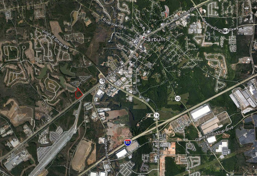
2 LOCATION MAP

3 LOCATION MAP
4 AERIAL
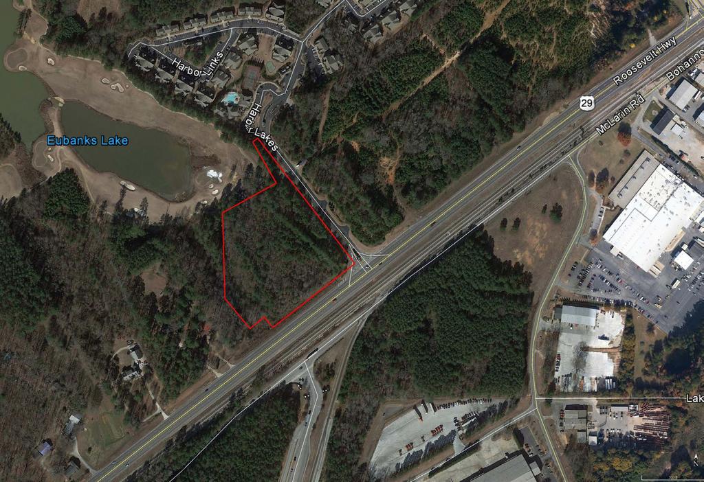
5 AERIAL

6 The Drawings, Specifications and other SURVEY VICINITY MAP N.T.S. SITE SURVEY NOTES: UTILITIES SHOWN ARE LOCATIONS OF GROUND IDENTIFIABLE ITEMS. ADDITIONAL UTILITIES MAY EXIST ABOVE OR BELOW GROUND. THE SURVEYOR ACCEPTS NO RESPONSIBILITY FOR THE COMPLETENESS OF THIS DATA. THE FIELD DATA UPON WHICH THIS PLAT IS BASED HAS A CLOSURE PRECISION OF ONE FOOT IN 61,144 FEET, AND AN ANGULAR ERROR OF 03 SECONDS PER ANGLE, IT WAS A CLOSED LOOP AND WAS ADJUSTED USING THE COMPASS RULE. THIS PLAT HAS BEEN CALCULATED FOR CLOSURE AND IS FOUND TO BE ACCURATE WITHIN ONE FOOT IN 237,073 FEET. LINEAR AND ANGULAR MEASUREMENTS WERE OBTAINED USING A TRIMBLE S6 ROBOTIC TOTAL STATION. THE FIELDWORK WAS COMPLETED 05/15/14 ON THIS PROJECT. THIS PROPERTY IS SUBJECT TO ALL RIGHT OF WAYS AND EASEMENTS SHOWN OR NOT SHOWN, RECORDED OR UNRECORDED THIS SURVEY WAS PREPARED WITHOUT BENEFIT OF A TITLE REPORT WHICH COULD REVEAL ENCUMBRANCES NOT SHOWN. IN MY OPINION, THIS IS A TRUE AND CORRECT REPRESENTATION OF THIS PROPERTY AND HAS BEEN PREPARED IN CONFORMITY WITH THE MINIMUM STANDARDS AND REQUIREMENTS OF THE LAW. THIS PROPERTY IS LOCATED IN A ZONE X (AREA OF MINIMAL FLOOD HAZARD) AREA PER FEMA FIRM COMMUNITY PANEL NUMBER 13121C0461F DATED SEPTEMBER 18, P:\Capital City Bank\Durham Commercial - CCB\DLC-CCB-BNDRY.dwg, 18X24, smoore, May 20, :12:23am GRAPHIC SCALE inch = 60 ft. COA # SURVEY REFERENCES: FULTON COUNTY RECORDS: DEED BOOK PAGE 121 DEED BOOK PAGE 125 DEED BOOK PAGE 5 DEED BOOK PAGE 183 DEED BOOK PAGE SDM GWW DLC-CCB-BNDRY.dwg documents prepared by Moore Bass Consulting, Inc. (MB) for this Project are instruments of MB for use solely with respect to this Project and, unless otherwise provided, MB shall be deemed the author of these documents and shall retain all common law, statutory and other reserved rights, including the copyright. BOUNDARY SURVEY IN LAND LOTS 175 & 176, 7TH DISTRICT FULTON COUNTY, GEORGIA DURHAM LAKES COMMERCIAL FAIRBURN, GEORGIA FULTON COUNTY, GEORGIA CAPITAL CITY BANK 304 EAST TENNESSEE STREET TALLAHASSEE, FL IPF IPS CMF LP W ICV OE FM X LEGEND: CALCULATED POINT IRON PIN FOUND (AS LABELED) IRON PIN SET (1/2" REBAR) CONCRETE MONUMENT FOUND LIGHT POLE POWER / UTILITY POLE FIRE HYDRANT WATER METER IRRIGATION CONTROL VALVE WATER VALVE OVERHEAD ELECTRIC SANITARY SEWER LINE CHAIN LINK FENCE 324 INDUSTRIAL BLVD., MCDONOUGH, GA (770)
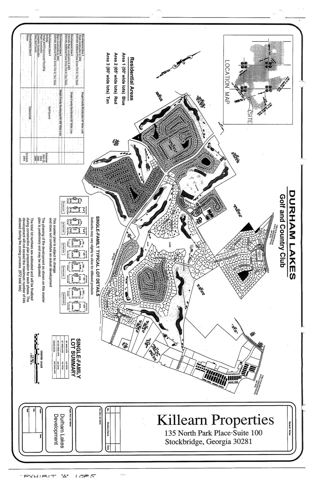
7 MASTER SITE PLAN 7.23 Acres
8
9
10
11
12
13
14
15
PLANNING COMMISSION SUBDIVISION PLAT APPLICATION
 PLANNING COMMISSION SUBDIVISION PLAT APPLICATION Economic Development Department 3468 North Fulton Avenue Hapeville, Georgia 30354 Phone - 404.669.8269 Fax 404.669.3302 Rev. 09/23/16 1 The following information
MINOR SUBDIVISION PLAT CHECKLIST
 MINOR SUBDIVISION PLAT CHECKLIST Project Name: Tax ID #: Project Number: Date: _ Reviewed By: Telephone: NOTES: All lots on septic systems must comply with the Fulton County Health Department requirements
FINAL PLAT CHECKLIST
 FINAL PLAT CHECKLIST Project Name: Tax ID #: Project Number: Date: _ Reviewed By: Telephone: Please address all items marked with an "X" Please return redline comments with corrected plan, original mylar,
PLAT OF SURVEY VICINITY MAP (NOT TO SCALE) N N W E SITE BENCHMARK # 2 W E N&D ON BACK OF CURB NAVD 88 S S 0' 10' 20' 40' 60' 1" = 20' TOP=106.7
 N N W E SITE BENCHMARK # 2 W E N&D ON BACK OF CURB NAVD 88 S S 0' 10' 20' 40' 60' 1 = 20' TOP=106.7") PLAT OF SURVEY VICINITY MAP (NOT TO SCALE) N N W E SITE BENCHMARK # 2 W E N&D ON BACK OF CURB 106.21 NAVD 88 S S 0' 10' 20' 40' 60' 1" = 20' TOP=106.72 N INV PVC=99.27 S INV PVC=99.32 E INV CLAY=99.39
PLAT OF SURVEY VICINITY MAP (NOT TO SCALE) N N W E SITE BENCHMARK # 2 W E N&D ON BACK OF CURB 106.21 NAVD 88 S S 0' 10' 20' 40' 60' 1" = 20' TOP=106.72 N INV PVC=99.27 S INV PVC=99.32 E INV CLAY=99.39
PRIME HIGHWAY LOCATION Multi - Family Land Acres Waxahachie, Texas
 PRIME HIGHAY LOCATION Multi - Family Land 6.525 Acres axahachie, Texas LOCATION: SIZE: The subject property is located on the south side of U.S. Highway 287 Bypass, approximately 1.5 miles west of I-35E
INSTRUCTIONS FINAL PLAT APPROVAL APPLICATION
 INSTRUCTIONS FINAL PLAT APPROVAL APPLICATION 1. The applicant/agent shall fill out the attached application. The attached application form must be completely filled in before it can be filed. Portions
Palm Ave Hialeah Building Data Palm Avenue
 400-450 Palm Ave Hialeah Building Data Address 400-450 Palm Avenue City, State Hialeah, Florida County Miami Dade parcel # 04-3118-001-1950 and 1960 Zoning Retail Commercial - BU2 Land Size 13500 Type
COUNTY OF ADAMS, STATE OF COLORADO E. 40TH AVE. TOWER RD. E. 38TH AVE. SALIDA ST. HIGH LINE CANAL PROJECT LOCATION E. 32ND PKWY.
 LEGAL DESCRIPTION:, GATEWAY EAST AT TOWER SUBDIVISION FILING NO. 1, SAID PARCEL CONTAIN 598,154 SQUARE FEET OR MORE OR LESS GENERAL NOTES: 1. NOTICE: ACCORDING TO COLORADO LAW YOU MUST COMMENCE ANY LEGAL
AIR ONE. 829 HULL ROAD Ormond Beach, Florida BENCHMARK #1 EL NAIL IN POWER POLE EASTERLY RIGHT-OF-WAY LINE TOMOKA AIRPORT ROAD (UR) HULL ROAD
 HULL ROAD") NORTH LINE LOT 2 SOUTH LINE LOT 1 S75 46'55"E 2 NORTH LINE LOT 3 SOUTH LINE LOT 2 N75 43'32"W(UR) S75 43'32"E(D) N75 43'32"W(URD) NORTH LINE LOT 1 SOUTH LINE LOT 12 225.15'(M)225'(UR) P.O.R. PARCELS II
NORTH LINE LOT 2 SOUTH LINE LOT 1 S75 46'55"E 2 NORTH LINE LOT 3 SOUTH LINE LOT 2 N75 43'32"W(UR) S75 43'32"E(D) N75 43'32"W(URD) NORTH LINE LOT 1 SOUTH LINE LOT 12 225.15'(M)225'(UR) P.O.R. PARCELS II
RULES OF THE GEORGIA STATE BOARD OF REGISTRATION FOR PROFESSIONAL ENGINEERS AND LAND SURVEYORS CHAPTER APPLICATIONS TABLE OF CONTENTS
 RULES OF THE GEORGIA STATE BOARD OF REGISTRATION FOR PROFESSIONAL ENGINEERS AND LAND SURVEYORS CHAPTER 180-7 APPLICATIONS TABLE OF CONTENTS 180-7-.07 Maps and Plats. All maps, plats and similar documents
DAWSON COUNTY MINOR PLAT REVIEW CHECKLIST $50.00 FEE PER PLAT REVIEW, $5.00 FEE FOR SCAN & CD FOR RECORDING
 DAWSON COUNTY MINOR PLAT REVIEW CHECKLIST $50.00 FEE PER PLAT REVIEW, $5.00 FEE FOR SCAN & CD FOR RECORDING NAME ON PLAT: CONTACT/PHONE #: NAMED STREET/ADDRESS: LAND LOT: DISTRICT: SECTION: ZONING: SETBACKS:
ARTICLE 900 PLAT AND PLAN REQUIREMENTS
 ARTICLE 900 PLAT AND PLAN REQUIREMENTS SEC. 900.1 ITEMS TO BE SHOWN ON PLAT OR PLAN General (1) Property lines of all property owners adjacent to the exterior boundaries of the project shall be located
APPLICATION FOR FINAL PLAT APPROVAL (Major Subdivision)
") APPLICATION FOR FINAL PLAT APPROVAL (Major Subdivision) CITY OF HOSCHTON, GA PLANNING AND DEVELOPMENT 79 City Square Hoschton, GA 30548 706-654-3034 Applicant Information: Name: Address: City, State, Zip:
APPLICATION FOR FINAL PLAT APPROVAL (Major Subdivision) CITY OF HOSCHTON, GA PLANNING AND DEVELOPMENT 79 City Square Hoschton, GA 30548 706-654-3034 Applicant Information: Name: Address: City, State, Zip:
CLARK 3925 E. US 377 COMMERCIAL $699,000 COMMERCIAL PAD SITE IN FRONT OF NEW KROGER. Granbury, Texas
 PAD SITE IN FRONT OF NEW KROGER $699,000 1.858 Acres Monument sign on 377 377 road frontage Platted Zoned Utilities to the site PROPERTY INFORMATION Property Information: Adjacent to recently opened Kroger
BOUNDARY LINE ADJUSTMENT/CERTIFICATE OF SURVEY DEFINITION AND INSTRUCTIONS
 BOUNDARY LINE ADJUSTMENT SURVEY (BLA) BOUNDARY LINE ADJUSTMENT/CERTIFICATE OF SURVEY DEFINITION AND INSTRUCTIONS DEFINITION: The adjustment of one (1) or more common boundaries between existing un-platted
Standards of Practice for Surveying in the State of Alabama
 Standards of Practice for Surveying in the State of Alabama Effective January 1, 2017 RULE NO. 1.01 PURPOSE The purpose of these rules is to establish standards for the practice of surveying in the State
CITY OF FAYETTEVILLE, ARKANSAS FINAL PLAT FOR STAFF USE ONLY FINAL PLAT FEE: $ $ Date Application Submitted: Date Accepted as Complete:
 CITY OF FAYETTEVILLE, ARKANSAS FINAL PLAT FOR STAFF USE ONLY FINAL PLAT FEE: $200.00-$800.00 Date Application Submitted: Date Accepted as Complete: Project Number: Public Hearing S-T-R: PP#: Zone: Please
CONSTRUCTION PLANS for HALCYON A RESIDENTIAL SUBDIVISION 6100 MIDNIGHT PASS ROAD, SARASOTA, FL 34242
 CONSTRUCTION PLANS for HALCYON A RESIDENTIAL SUBDIVISION 6100 MIDNIGHT PASS ROAD, SARASOTA, FL 34242 SECTION 18, TOWNSHIP 37 SOUTH, RANGE 18 EAST SARASOTA COUNTY, FLORIDA PID: 0030001 A DEVELOPMENT BY
PRELMINARY PLAT CHECKLIST
 PRELMINARY PLAT CHECKLIST A. All preliminary plat submitted for approval shall be prepared by a Registered Professional Land Surveyor. B. Preliminary plats must be drawn to a scale of XXX with such accuracy
SKETCH OF BOUNDARY SURVEY ALTA / ACSM LAND TITLE SURVEY
 SKETCH OF BOUNDARY SURVEY ALTA / ACSM LAND TITLE SURVEY SURVEYOR'S NOTES: All distances as shown hereon are based on the US Survey foot. Subject property lies inside the UBD (Urban Development Boundary),
PLANNING COMMISSION REPORT Non-Public Hearing Item
 PC Staff Report 09/21/2015 Item No. 2B - 1 PLANNING COMMISSION REPORT Non-Public Hearing Item PC Staff Report 09/212015 ITEM NO. 2B: FINAL PLAT FOR MORGAN ADDITION; 800 MONTEREY WAY (MKM) : Consider a
2213 BUTLER PAD SITE NEAR NEW PARKLAND HOSPITAL. Butler Street at Redfield Dallas, Texas EDGE REALTY PARTNERS
 PAD SITE NEAR NEW PARKLAND HOSPITAL 2213 BUTLER Butler Street at Redfield Dallas, Texas EDGE REALTY PARTNERS 2213 BUTLER // Dallas, Texas LOCATION 2213 Butler Street Dallas, Texas 75235 SIZE 83,370 square
D OWNER'S AGENT 0 PROPERTY OWNER D CONTRACT PURCHASER
 Last Updated 12/20 I 5 REZONING APPLICATION AN APPLICATION TO AMEND THE OFFICIAL ZONING MAP OF GWINNETT COUNTY, GA. APPLICANT INFORMATION PROPERTY OWNER INFORMATION* NAME: Jose Sanchez NAME: Jose Sanchez
2800 OAK LAWN AVENUE ± 25,000 SF ON OAK LAWN AVE AVAILABLE FOR LEASE. SEC Oak Lawn Ave & Congress Ave Dallas, Texas EDGE REALTY PARTNERS
 ± 25,000 SF ON OAK LAWN AVE AVAILABLE FOR LEASE 2800 OAK LAWN AVENUE SEC Oak Lawn Ave & Congress Ave Dallas, Texas EDGE REALTY PARTNERS LOCATION 2800 Oak Lawn Avenue Dallas, Texas 75219 SIZE ± 25,000 square
APPENDIX B. SUBMISSION REQUIREMENTS
 Master Major Site Minor Site Landscape Section B.1 Table of /Plat Requirements Proposed or approved name of development, project, subdivision, and/or phase. Location, including township, county, and state.
Development Review Committee Application
 City of Coral Gables, Florida Level 2 Review Development Review Committee Application Address: 427 Biltmore Way, 2 nd Floor, Coral Gables, Florida 33134 Email: planning@coralgables.com Phone: 305.460.5211
SUBDIVISION APPLICATION: RECOMBINATION PLAT or EXEMPT PLAT
 SUBDIVISION APPLICATION: RECOMBINATION PLAT or EXEMPT PLAT Pursuant to Article 7, Section 155.706 of the Unified Development Code, an owner of land within the jurisdiction of the Town (or a duly authorized
ALTA/NSPS LAND TITLE SURVEY
 ALTA/NSPS LAND TITLE SURVEY VICINITY MAP COMMITMENT FILE NO. 142792 PEAVEY ROAD COLUMBIA CT W COLUMBIA CT N Most northerly corner of Tract K, RLS No. 48 OWNER: CITY OF CHASKA, MINNEOSTA FND OPEN IP RLS
DIVISION 2 - CONSTRUCTION PLAN AND MISCELLANEOUS REQUIREMENTS
 DIVISION 2 - CONSTRUCTION PLAN AND MISCELLANEOUS REQUIREMENTS 2.1 Required Plan Sheets 2.2 Drawing Requirements 2.3 Graphic Standards 2.4 Easements 2.5 Utility Locations 2.6 Private Facility Locations
HERMISTON PLANNING COMMISSION. Regular Meeting May 10, 2017
 HERMISTON PLANNING COMMISSION Regular Meeting May 10, 2017 Commissioner Saylor called the meeting to order at 7:00 PM. Commissioners Caplinger, Doherty, Hamm, Flaiz, Fialka and Frederic were present. Commissioners
SUBDIVISION APPLICATION
 SUBDIVISION APPLICATION City of Horn Lake Planning Department 3101 Goodman Road, W Horn Lake, MS 38637 662-342-3559 Fax: 662-342-3485 Applications due the 1st working day of the month. Submit application
PARCEL MAP CHECK ENG
 Engineering Division 201 North Broadway, Escondido, CA 92025 (760) 839-4651, FAX (760) 839-4597 PARCEL MAP CHECK ENG To: Date: Project: Site Address Check No. Attn: Via: The attached plans have been reviewed
Rule 21 STANDARDS OF PRACTICE FOR SURVEYING
 Rule 21 STANDARDS OF PRACTICE FOR SURVEYING 21.1 Whenever a survey is performed, it shall comply with Section 73-13-71 (4) and Section 73-13- 73 and the Standards of Practice for Surveying in Mississippi
FINAL MAP PLAN CHECK
 Engineering Division 201 North Broadway, Escondido, CA 92025 (760) 839-4651, FAX (760) 839-4597 FINAL MAP PLAN CHECK To: Date: Project: Address: Check No: Attn: VIA: The attached FINAL MAP has been reviewed
Plats and subdivisions; mapping requirements. (a) Size Requirements. All land plats presented to the register of deeds for recording in the
 Size Requirements. All land plats presented to the register of deeds for recording in the") 47-30. Plats and subdivisions; mapping requirements. (a) Size Requirements. All land plats presented to the register of deeds for recording in the registry of a county in North Carolina after September
47-30. Plats and subdivisions; mapping requirements. (a) Size Requirements. All land plats presented to the register of deeds for recording in the registry of a county in North Carolina after September
CHAPTER 26 PLANNING AND ZONING ARTICLE VII. MOBILE HOMES AND RECREATIONAL VEHICLE (RV) PARKS. Recreational Vehicle (RV) Park Development Standards
 PARKS. Recreational Vehicle (RV) Park Development Standards") CHAPTER 26 PLANNING AND ZONING ARTICLE VII. MOBILE HOMES AND RECREATIONAL VEHICLE (RV) PARKS. Section 26-VII-1. Section 26-VII-2. Section 26-VII-3. Section 26-VII-4. Section 26-VII-5. Purpose Permitted
CHAPTER 26 PLANNING AND ZONING ARTICLE VII. MOBILE HOMES AND RECREATIONAL VEHICLE (RV) PARKS. Section 26-VII-1. Section 26-VII-2. Section 26-VII-3. Section 26-VII-4. Section 26-VII-5. Purpose Permitted
Certified Survey Review Instructions
 DEARBORN COUNTY PLAN COMMISSION County Administration Building, 165 Mary St., Lawrenceburg, IN 47025 Phone (812) 537-8821 Fax (812) 532-2029 Website: www.dearborncounty.org/planning Certified Survey Review
City of Clever Planning & Zoning Department P.O. Box 52 Clever, MO QUALIFICATIONS FOR MINOR SUBDIVISIONS
 QUALIFICATIONS FOR MINOR SUBDIVISIONS All subdivision of land not otherwise classified as a major subdivision shall be classified as a minor subdivision and shall be subject to the procedures adopted by
Location Map. Subject Site. Project Name: Boulder Lakes 4th Addn. Request: Preliminary Subdivision Case No.: 01-PS INVER GROVE HEIGHTS
 HOLIDAY LN LOUIS LANE INVER GROVE HEIGHTS AMES CROSSING RD STATE TRUNK HWY. NO. 55 CHAPEL LANE O'NEILL DR VIKINGS PARKWAY LONE OAK DRIVE C.S.A.H. NO. 26 (LONE OAK RD.) COURTHOUSE LN TRUNK HWY. NO. 55 JOYCE
City of Fort Lupton Amended Plat Process
 City of Fort Lupton Amended Plat Process Purpose The Amended Plat process is an administrative process to amend a recorded Plat. An Amended Subdivision is an administrative revision to a recorded Subdivision
OHIO ADMINISTRATIVE CODE CHAPTER Minimum Standards for Boundary Surveys in the State of Ohio
 OHIO ADMINISTRATIVE CODE CHAPTER 4733-37 Minimum Standards for Boundary Surveys in the State of Ohio Note: Chapter 4733-37 of the Administrative Code was filed pursuant to Chapter 119 of the Revised Code.
250 CMR: BOARD OF REGISTRATION OF PROFESSIONAL ENGINEERS AND LAND SURVEYORS DRAFT FOR DISCUSSION PURPOSES ONLY
 250 CMR 6.00: LAND SURVEYING PROCEDURES AND STANDARDS Section 6.01: Elements Common to All Survey Works 6.02: Survey Works of Lines Affecting Property Rights All land surveying work is considered work
City of Prior Lake APPLICATION FOR COMBINED PRELIMINARY AND FINAL PLAT
 Case File No. Property Identification No. City of Prior Lake APPLICATION FOR COMBINED PRELIMINARY AND FINAL PLAT Requested Action Brief description of proposed project (Please describe the proposed amendment,
GRAND RESERVE AT LITCHFIELD 68 Developed Lots & 25 Future Lots Arnold Mill Road City of Roswell, Fulton County, GA
 GRAND RESERVE AT LITCHFIELD 68 Developed Lots & 25 Future Lots Arnold Mill Road City of Roswell, Fulton County, GA GRAND RESERVE : OFFERING MEMORANDUM 68 Developed Lots & 25 Future Lots City of Roswell
Preliminary Subdivision Application (Minor) (Three (3) lots or less)
 (Three (3) lots or less)") Gunnison City Offices www.gunnisoncity.org 38 West Center Gunnison, Utah 84634 (435) 528 7969 Date of Application: Preliminary Subdivision Application (Minor) (Three (3) lots or less) APPLICANT INFORMATION
Gunnison City Offices www.gunnisoncity.org 38 West Center Gunnison, Utah 84634 (435) 528 7969 Date of Application: Preliminary Subdivision Application (Minor) (Three (3) lots or less) APPLICANT INFORMATION
City of Prior Lake APPLICATION FOR REGISTERED LAND SURVEY
 Case File No. Property Identification No. City of Prior Lake APPLICATION FOR REGISTERED LAND SURVEY Requested Action Brief description of proposed project (Please describe the proposed amendment, project,
DATE: May 16, Honorable Mayor City Council Members. Laura Holey, Planner
 DATE: May 16, 2015 TO: FROM: Honorable Mayor City Council Members Laura Holey, Planner AGENDA ITEM: 11 C. Vacation of Easement 821 Corporate Drive REQUIRED ACTION: The City Council is asked to conduct
SECTION SITE SURVEYS
 PART 1 - GENERAL 1.1 DESCRIPTION SECTION 02 21 00 SPEC WRITER NOTES: 1. Use this section only for NCA projects. 2. Delete between //---// if not applicable to project. Also delete any other item or paragraph
Walton County Planning and Development Services
 Walton County Planning and Development Services 31 Coastal Centre Boulevard, Suite 100 47 N 6 th Street Santa Rosa Beach, Florida 32459 DeFuniak Springs, Florida 32433 Phone 850-267-1955 Phone 850-892-8157
Gates County Planning and Zoning
 Gates County Planning and Zoning PO Box 411, 200 Court Street, Gatesville, NC 27938 phone: 252-357-2411 fax: 252-357-0073 Application for Technical Review Committee For Staff Use Only: Date: Application
ORDINANCE NO. Be it ordained by the City Council of the City of Abilene, Texas:
 ORDINANCE NO. An ordinance repealing Chapter 23, Subpart B of the Code of the City of Abilene, Texas, entitled Mobile Homes and Vacation Travel Trailers; stating the authority; setting forth the scope
SUBDIVISION APPLICATION
 SUBDIVISION APPLICATION Preliminary Plat Minor Plat Final Plat Amended Plat Applicant Name: Owner (if different from applicant) Name: Company: Company: Address: Address: City, State, Zip City, State, Zip
NOT TO BE SUBMITTED WITH SKETCH DESIGN APPROVAL Subdivision Checklist: Major Subdivision Final Plat
 Must be received with review fee (equal to $200.00, plus $25.00 per lot) no later than 15 days prior to Planning Board meeting, which is normally the first Monday of the month (certain holidays may modify
RAM. full service car lot for sale. Real Estate Asset Management S. Decatur BLVD. las vegas, nevada 89102
 RAM PRESENTED BY Information herein has been obtained from sources deemed reliable, however its accuracy cannot be guaranteed. The user is required to conduct their own due diligence and verification.
LARAMIE COUNTY PLANNING & DEVELOPMENT DEPARTMENT
 LARAMIE COUNTY PLANNING & DEVELOPMENT DEPARTMENT Planning Building MEMORANDUM TO: FROM: Laramie County Planning Commission Nancy M. Trimble, Associate Planner DATE: July 13, 2017 TITLE: Review and action
SUBMITTAL REQUIREMENTS
 PRELIMINARY PLAT APPLICATION ***A PRE-APPLICATION MEETING WITH CITY STAFF IS REQUIRED FOR THIS APPLICATION*** DATE STAMP FOR CITY USE ONLY PROJECT NAME (if any): TO BE FILLED OUT BY APPLICANT PROJECT STREET
DEVELOPMENT POLICY INFRASTRUCTURE GUIDELINES FOR NEW DEVELOPMENT
 CITY OF HAYS SUBJECT DEVELOPMENT POLICY INFRASTRUCTURE GUIDELINES FOR NEW DEVELOPMENT ISSUED BY LAST REVISION DATE POLICY MANUAL REVISION DATE City Commission 3-13-08 10-22-09 POLICY STATEMENT: The City
CITY OF SARALAND PRELIMINARY SUBDIVISION PLAT REVIEW
 PRELIMINARY SUBDIVISION PLAT REVIEW Application Number: Date Plat Submitted: Name of Subdivision: Name of Owner: Owner Address: (Street or P.O. Box) Telephone #: (City) (State) (Zip) E-mail: Name of Authorized
WASTEWATER BACKFLOW RELEASE PROCEDURES
 WASTEWATER BACKFLOW RELEASE PROCEDURES PROCEDURE FOR OBTAINING A WASTEWATER RELEASE FOR PRIVATE DEVELOPMENT PROJECTS: PLEASE NOTE THAT THE WASTEWATER BACKFLOW RELEASE DOCUMENT MUST FOLLOW THE CITY S PROCEDURES.
 REZONING APPLICATION AN APPLICATION TO AMEND THE OFFICIAL ZO NING MAP OF GWINNETT COUNTY, GA. APPLICANT INFORMATION NAME: Dung Nguyen ADDREss: 6035 Singleton Rd. CITY: Norcross. PROPERTY OWNER INFORMATION*
Minor Subdivision Application
 FOR PLANNING USE ONLY Application # SD Application Fee $1,000.00 Receipt No. Filing Date Completeness Date Minor Subdivision Application A. PROJECT INFORMATION 1. Project Name: 2. Address of Subject Property:
Memorandum September 13, 2018
 Memorandum September 13, 2018 TO: FROM: Planning and Zoning Commission Julie Couch, Town Manager Israel Roberts, AICP Planning Manager SUBJECT: FINAL PLAT FOR THE EBERSOHL ADDITION BACKGROUND: This is
LARAMIE COUNTY PLANNING & DEVELOPMENT DEPARTMENT
 LARAMIE COUNTY PLANNING & DEVELOPMENT DEPARTMENT Planning Building MEMORANDUM TO: FROM: Laramie County Board of Commissioners Nancy M. Trimble, Associate Planner DATE: December 5, 2017 TITLE: Review and
A.3. ARTICLE 7 PLAN REQUIREMENTS FOR MINOR SUBDIVISION AND/OR LAND DEVELOPMENT
 700. 701.A.3. ARTICLE 7 PLAN REQUIREMENTS FOR MINOR SUBDIVISION AND/OR LAND DEVELOPMENT SECTION 700 PURPOSE The purpose of this Article is to set forth a streamlined set of Plan Requirements for minor
Community Development Department Council Chambers, 7:30 PM, July 20, 2017
 STAFF REPORT 2017-25P: Subdivision Community Development Department Council Chambers, 7:30 PM, July 20, 2017 To: From: Re: Paul Luke, Chairman, Skokie Plan Commission Mike Voitik, Planning Technician 2017-25P:
DALLAS WATER UTILITIES WATER/WASTEWATER COVENANT
 DALLAS WATER UTILITIES WATER/WASTEWATER COVENANT Procedure for obtaining a water and wastewater covenant, water covenant, or wastewater covenant; Required for initial submittal: 1. One letter from the
South Fulton Parkway PROPERTY FEATURES. Tract 1 +/- 56 Acres. Tract 2 +/- 29 Acres +/ ACRES ZONED MIXED USE > FOR SALE > UNION CITY
 +/- 84.5 ACRES ZONED MIXED USE > FOR SALE > UNION CITY South Fulton Parkway UNION CITY, FULTON COUNTY, GA Tract 1 +/- 56 Acres Providence at Parkway Village (Senior Living) Tract 2 +/- 29 Acres PROPERTY
MINOR SUBDIVISION APPLICATION
 Planning and Development 510 N. Baker St. Mount Dora, FL 32757 352-735-7112 Fax: 352-735-7191 plandev@cityofmountdora.com Date: Project Name: MINOR SUBDIVISION APPLICATION 1. Applicant s Name: 2. Property
PRELIMINARY PLAT CHECK LIST
 PRELIMINARY PLAT CHECK LIST Name of Proposed Subdivision: The following items must be included with the initial submittal of a Preliminary Plat: Application, filled out completely Project Narrative Pre-application
Land Surveys and Real Property Boundaries
 Land Surveys and Real Property Boundaries There are primarily 5 types of surveys performed on real property in the State of Indiana: Original, Retracement, Route, and Surveyor Location Report (SLR). Lenders
Subdivision of existing two lots into three lots.
 PP-15-00189 Item No. 4-1 PC Staff Report 06/22/2015 PLANNING COMMISSION REPORT NON PUBLIC HEARING ITEM PUBLIC HEARING ON THE VARIANCE ONLY ITEM NO 4: PRELIMINARY PLAT FOR DEERFIELD WOODS SUBDIVISION NO.
COMMUNITY DEVELOPMENT DEPARTMENT. To: Board of Commissioners VIA: Finance Committee. From: David Hainley, Director. Re:
 COMMUNITY DEVELOPMENT DEPARTMENT 1725 Reynolds Street, Suite 200, Brunswick, GA 31520 To: Board of Commissioners VIA: Finance Committee From: David Hainley, Director Re: Accepting 0.744 acres of land and
FINAL PLAN CHECKLIST
 FINAL PLAN CHECKLIST Subdivision Name: Subdivision Number: Project Number: REVIEW CRITERIA Plans: A final plan shall be on a 24 x 36 sheet at a scale that is no smaller than 1 = 40 and shall contain all
ALBA BEACH SUBDIVISION, RESUBDIVISION OF LOT 17
 ALBA BEACH SUBDIVISION, RESUBDIVISION OF LOT 17 Engineering Comments: FINAL PLAT COMMENTS (should be addressed prior to submitting the FINAL PLAT for acceptance and signature by the City Engineer): A.
CHAPTER FINAL AND PARCEL MAPS
 CHAPTER 19.48 FINAL AND PARCEL MAPS Section Page 19.48.010 General... IV-25 19.48.020 Phasing... IV-25 19.48.030 Survey Required... IV-26 19.49.040 Form... IV-26 19.48.050 Contents... IV-27 19.48.060 Preliminary
SUBDIVISION PLAT CHECKLIST. The following information shall be include on the plat:
 SUBDIVISION PLAT CHECKLIST Subdivision Name: Land Surveyor: Owner/Developer: Date Submitted: The following information shall be include on the plat: The plat shall be drawn at a scale of one inch equals
PLANNED UNIT DEVELOPMENT CITY OF CHAMBLEE, GA
 Exhibit A Received 11/7/17 PLANNED UNIT DEVELOPMENT CITY OF CHAMBLEE, GA SHEET DESCRIPTION PAGE SITE DATA VICINITY MAP INDEX PAGE 1 EXISTING ZONING CC PUD PROJECT DESCRIPTION 2-3 PROPOSED ZONING CC PUD
SUBDIVISION REGULATIONS
 SUBDIVISION REGULATIONS A Brief Summary Monroe County Madisonville Sweetwater Tellico Plains Vonore Monroe County, Tennessee Monroe County Planning Department 103 College Street South JP Kennedy Building
PLANNING COMMISSION STAFF REPORT
 PLANNING COMMISSION STAFF REPORT Alder-Robinson Subdivision Amending the Amended Plat of the Arcadia Heights Plat A Subdivision Case #PLNSUB2010-00044 2857 East 2100 South June 23, 2010 Applicant: Greg
LARAMIE COUNTY PLANNING & DEVELOPMENT DEPARTMENT
 LARAMIE COUNTY PLANNING & DEVELOPMENT DEPARTMENT Planning Building MEMORANDUM TO: FROM: Laramie County Planning Commission Nancy M. Trimble, Associate Planner DATE: November 9, 2017 TITLE: Review and action
BOUNDARY ADJUSTMENT APPLICATION
 BOUNDARY ADJUSTMENT APPLICATION COMMUNITY DEVELOPMENT DEPARTMENT / PLANNING DIVISION 8130 Allison Avenue, La Mesa, CA 91942 Phone: 619.667.1177 Fax: 619.667.1380 NOTE: The City of La Mesa emphasizes that
GENERAL ASSEMBLY OF NORTH CAROLINA SESSION 2017 H 1 HOUSE BILL 454* Short Title: Surveying and Plat Recording Changes. (Public)
") GENERAL ASSEMBLY OF NORTH CAROLINA SESSION H 1 HOUSE BILL * Short Title: Surveying and Plat Recording Changes. (Public) Sponsors: Referred to: Representative Arp. For a complete list of sponsors, refer
GENERAL ASSEMBLY OF NORTH CAROLINA SESSION H 1 HOUSE BILL * Short Title: Surveying and Plat Recording Changes. (Public) Sponsors: Referred to: Representative Arp. For a complete list of sponsors, refer
ARTICLE XVI SUBDIVISION DEVELOPMENT
 ARTICLE XVI SUBDIVISION DEVELOPMENT 16.0 The division of land into 4 or more lots that will require the construction or extension of public streets, water or sanitary sewerage (other than the direct connection
Enforcement of Minimum Survey Standards
 Presented By: F. Anthony Rettke, P.S., Tax Map Supervisor, Franklin County John Greenhalge, Executive Director, State Board of Registration n the Ohio Revised Code, Section 315.251: If a deed conveying
VAR17-03 St. Charles County Board of Zoning Adjustment
 VAR17-03 St. Charles County Board of Zoning Adjustment 79 FARM VIEW LN - VARIANCE REQUEST Application: Owner: Applicant: Variance Requested: Zoning: Area: Location: Council District: 1 Account No.: 676770A000
Honorable Mayor Bill Agan and members of the Richland Hills City Council. Final Plat Richland Hills, Lots 1 & 2, Block 1 Brumlow Addition
 2B - 1 Memorandum To: From: Date: Subject: Honorable Mayor Bill Agan and members of the Richland Hills City Council Jason Moore, Assistant City Manager January 17, 2017 Final Plat Richland Hills, Lots
Residential Major Subdivision Review Checklist
 Residential Major Subdivision Review Checklist Plan Submittal Requirements: 2 full sets of stamped plans Electric submittal - all plans contained in a single PDF 3 full sets if commercial kitchen or dining
The legal descriptions used in Georgia (the metes and bounds, and plat map also known as the lot and block system) appear in Chapter 27.
 appear in Chapter 27.") Chapter 28 Legal Descriptions in the Sales Transaction INTRODUCTION The legal descriptions used in Georgia (the metes and bounds, and plat map also known as the lot and block system) appear in Chapter
Chapter 28 Legal Descriptions in the Sales Transaction INTRODUCTION The legal descriptions used in Georgia (the metes and bounds, and plat map also known as the lot and block system) appear in Chapter
MAPLETON CITY CORPORATION. Step 7: Upon final approval and prior to plat recording the applicant shall provide the following:
 MAPLETON CITY CORPORATION Subdivision Process The City s subdivision requirements are designed to facilitate orderly, safe and efficient development and to implement the adopted General Plan. Below is
Preliminary Subdivision Application (Major) (Four (4) lots or more)
 (Four (4) lots or more)") Gunnison City Offices www.gunnisoncity.org 38 West Center Gunnison, Utah 84634 (435) 528 7969 Date of Application: Preliminary Subdivision Application (Major) (Four (4) lots or more) APPLICANT INFORMATION
Gunnison City Offices www.gunnisoncity.org 38 West Center Gunnison, Utah 84634 (435) 528 7969 Date of Application: Preliminary Subdivision Application (Major) (Four (4) lots or more) APPLICANT INFORMATION
10± AC TOWNHOME SITE STONEWALL TELL TOWNHOMES STONEWALL TELL CAMPBELLTON ROAD CITY OF SOUTH FULTON, GA
 10± AC TOWNHOME SITE STONEWALL TELL TOWNHOMES STONEWALL TELL ROAD @ CAMPBELLTON ROAD CITY OF SOUTH FULTON, GA Confi dentiality Agreement & Disclaimer This is a confi dential Memorandum intended solely
SUBDIVISION APPLICATION CHECKLIST SKETCH PLAN PRELIMINARY PLAT FINAL PLAT
 RECEIVED STAMP SUBDIVISION APPLICATION CHECKLIST SKETCH PLAN PRELIMINARY PLAT FINAL PLAT A checklist of background information and submission requirements for processing of a sketch plan, preliminary plat
PLANNED UNIT DEVELOPMENT & SUBDIVISION STAFF REPORT Date: September 15, 2016
 # 10 SUB2016-00089 PLANNED UNIT DEVELOPMENT & SUBDIVISION STAFF REPORT Date: September 15, 2016 NAME SUBDIVISION NAME LOCATION Lot 12 Laughlin Industrial Park Subdivision Lot 12 Laughlin Industrial Park
Planning & Zoning Commission Staff Report for Honey Bee Acres Subdivision, SD-PH
 Planning & Zoning Commission Staff Report for Honey Bee Acres Subdivision, SD-PH2018-0009 Hearing Date: August 16, 2018 Development Services Department Applicant: Kelley & Carrie Dick Staff: Kyle McCormick,
FOR SALE 92 Acres Cultivated and Pasture Land Chilton, Falls County, TX 76632
 Cultivated and Pasture Land Chilton, Falls County, TX 76632 $228,700 For a virtual tour and investment offering go to: www.texasfarmandranchrealty.com/sales.htm Property Highlights Acres 92.39 acres MOL
Residential Minor Subdivision Review Checklist
 Residential Minor Subdivision Review Checklist Plan Submittal Requirements: 2 full sets of stamped plans Electric submittal - all plans contained in a single PDF 3 full sets if commercial kitchen or dining
STONE COUNTY PRELIMINARY PLAT CHECKLIST. Note: Applications need to be in the office by 2 p.m. on the cutoff day.
 STONE COUNTY PRELIMINARY PLAT CHECKLIST Note: Applications need to be in the office by 2 p.m. on the cutoff day. JOY WILSON, DIRECTOR Return form to: Planning & Zoning Administrator PO Box 301, Galena,
FOR SALE OR LEASE. Manufacturing / Distribution Facility 85,262± Square Feet (Divisible) Acres
 Acres") FOR SALE OR LEASE Manufacturing / Distribution Facility 85,262± Square Feet (Divisible) 15.65 Acres 330 Southwell Boulevard Tifton, Tift County, Georgia 31794 SALES PRICE: $4,000,000 LEASE RATE: $2.00/PSF,
FOR SALE OR LEASE Manufacturing / Distribution Facility 85,262± Square Feet (Divisible) 15.65 Acres 330 Southwell Boulevard Tifton, Tift County, Georgia 31794 SALES PRICE: $4,000,000 LEASE RATE: $2.00/PSF,
COUNTY OF ALBEMARLE APPLICATION FOR RURAL SUBDIVISION
 Page 1 APPLICATION FOR RURAL SUBDIVISION The term rural subdivision means a type of subdivision that is located in the rural areas which results in two or more lots for the purpose of transfer of ownership
VICINITY MAP/AERIAL MAP SITE
 VICINITY MAP/AERIAL MAP SITE N ZONING MAP PA 9 PA 5 SITE Solterra West ODP PA 7 N , DATE, 2013, TIME, COUNTY OF JEFFERSON, STATE OF COLORADO, $ DEDICATION CERTIFICATE THE UNDERSIGNED, BEING THE OWNER(S)