Planning & Zoning Commission Staff Report for Honey Bee Acres Subdivision, SD-PH
|
|
|
- Cuthbert Daniels
- 5 years ago
- Views:
Transcription

1 Planning & Zoning Commission Staff Report for Honey Bee Acres Subdivision, SD-PH Hearing Date: August 16, 2018 Development Services Department Applicant: Kelley & Carrie Dick Staff: Kyle McCormick, Planner Tax ID: R Parcel Size 5 acres Current Uses: Vacant Current Zone: R-R (Rural Residential) Comprehensive Plan Designation: Residential Applicable Zoning Land Use Regulations: CCZO , Notification: 7/23/18 Agencies 7/23/18 JEPA (Middleton) 7/31/2018 Publication 7/23/18 Property Owner 8/3/18 Posting Exhibits: 1. Findings of Fact, Conclusions of Law, Conditions of Approval, & Order 2. Southwest District Health 3. Small Aerial Map 4. Idaho Statute City of Middleton 6. Preliminary & Final Plat of Honey Bee Acres Subdivision 7. ITD Comments 8. Site Plan showing septic location on BP Greenview Acres Subdivision Plat 10. Applicants site plan 11. Large Aerial Request A request by Kelley Dick for approval of a Preliminary Plat and Final for Honey Bee Acres Subdivision, a replat of Lot 18 Block 1 of Greenview Acres Subdivision. The development consists of 2 lots and is accessed from Honey Bee Ct. The subject property is located at Honey Bee Ct., Middleton, ID 83644, further described as a portion of the Northwest quarter of Section 10, Township 4N, Range 2W, Canyon County, ID. Background The subject property is located in an R-R Rural Residential Zone. A Short Plat application was filed on 06/04/2018. The subject parcel currently has one primary residence and is currently constructing a secondary residence (BP ). Due to bank financing on the new house, the applicant has decided to pursue this rezone to split off the secondary residence being built now under permit # BP The applicant is required to apply for a short plat application to re-plat lot 18 of Block 1 in Greenview Acres (Exhibit 9). The subject parcel s access off of Honey Bee Ct. a private road with road user s maintenance agreement (Inst# ). Analysis The subject property is located in an R-R (Rural Residential) Zone. CCZO states that the purpose of the R-R (Rural Residential) Zone is to encourage and guide growth in areas where a rural lifestyle may be determined to be suitable. The applicant is proposing two (2) residential lots. One lot being approximately 2.61 acres in size and the other lot being approximately 2.64 acre in size. The minimum lot size in the R-R (Rural Residential) Zone is two (2) acres. Irrigation water available to the property in compliance with Idaho Code (exhibit 4) via gravity irrigation from Middleton Mill Ditch Company. Domestic Water is supplied via a shared well. A recorded Water User s Maintenance Agreement is required. Southwest District Health has stated that they need to verify septic location prior to signing the final plat (Exhibit 2). Septic systems have already been installed on each property and will not be impacted by the proposed lot lines (Exhibit 8, Site plan, BP ). Prior to Final Plat approval, the applicant must gain approval from Canyon Highway District #4 on the waiving of the 70 section line setback as noted on the Plat.
2 The City of Middleton stated in their comments that they have no concerns with the requested subdivision plat, and they waived the 30 day noticing requirement required per the Area of City Impact Area agreement (exhibit 5). Keller and associates, the County Engineer is currently reviewing the plat and will provide comments prior to the public hearing. All requirements suggested by the County Engineer will be required to be completed prior to final plat signatures by the Board of County Commissioners. The Idaho Department of Transportation has indicated that they have no objections to the request as presented and also mentioned that the approach to Hwy 44 was permitted under ITD Permit (exhibit 7). The subdivision meets Idaho Code and CCZO, Article 23 requirements for the preliminary and final plats. Preliminary Plat/Final Plat Standard of Review for Subdivision Plats A. Idaho Code, Sections , 6509 and 6535 (Subdivisions, Hearings, Decisions) B. Idaho Code, Sections through (Platting) C. Idaho Code, Section Irrigation-Delivery of Water. D. Canyon County Zoning Ordinance, Article 17 (Subdivision Regulations) Comments Public Comments At the time the staff report was prepared, staff had received no letters stating opposition to the proposed subdivision plat. County Agency Comments Staff informed agencies of the proposal and none of the agencies reported concerns with the request. Alternatives The Planning and Zoning Commission may recommend that the board approve, approve conditionally, modify or deny the plat(s). Significant Impacts There are no significant fiscal or environmental impacts from this application. Recommendation Staff recommends the Planning and Zoning Commission open a public hearing and discuss the proposed Plat(s). Staff is recommending approval of the application as provided findings of fact, conclusions of law for The Planning and Zoning Commission s consideration found in Exhibit 1. STAFF REPORT Honey Bee Acres Subdivision SD Page 2 of 2
3 Canyon County Planning & Zoning Commission Honey Bee Acres Subdivision, SD Development Services Department Findings 1. The property is currently zoned R-R (Rural Residential). 2. The proposed plats are in conformance with CCZO Article 17, Idaho Code, Sections , 6509 and 6535 (Subdivisions, Hearings, Decisions, and Idaho Code, Sections through (Platting), and Delivery of Water. 3. The property is located within the impact area for the City of Middleton. 4. The subdivision contains two (2) residential lots. 5. There is one existing residence and one residence being constructed (BP ) on the subject property. 6. Property owners within 300 feet of the subject property were notified on 7/23/18, agencies were notified of the request on 7/23/18, and the JEPA notice for Middleton was sent out on 7/23/18. The property was posted on 8/3/18 and the case was published in the Idaho Press Tribune on 7/31/ The City of Middleton waived the 30 day noticing requirement per the JEPA Agreements as required in CCZO and (exhibit 5) The record herein consists of exhibits provided as part of the public hearing staff report, other documents provided during the public hearing on August 16, 2018 and information within Case File SD Conclusions of Law The Planning and Zoning Commission has the authority to hear this case and recommend that it be approved, denied or modified. The public notice requirements were met and the hearing was conducted within the guidelines of applicable Idaho Code and County ordinances. Recommended Conditions of Approval 1. The development shall comply with all applicable federal, state, and county laws, ordinances, rules and regulations that pertain to the subject property. 2. All subdivision improvements and amenities shall be bonded or completed prior to the Board of County Commissioner s signature on the final plat. 3. Canyon Highway District #4 shall approve in writing, the waiver of the 70 section line setback common to section 3 and 10 prior to the Board of County Commissioner s signature on the final plat. 4. A Water Users Maintenance Agreement shall be recorded with the Canyon County Recorder s Office prior to issuance of residential building permits within the development. 5. Conditions of approval as required by Keller and Associates, the County Engineer, shall be completed prior to final plat approval. Honey Bee Acres Subdivision EXHIBIT 1 SD Page 1 of 2
4 Order Based upon the Findings of Fact, Conclusions of Law and Conditions of Approval contained herein the Planning & Zoning Commission approves Case # SD , a request by Kelley and Carrie Dick for approval of a Preliminary Plat and Final Plat for Honey Bee Acres Subdivision and forwards this case to the Board of County Commissioners with a recommendation of approval. APPROVED this day of, PLANNING AND ZONING COMMISSION CANYON COUNTY, IDAHO Richard Hall, Chairman State of Idaho ) County of Canyon County ) SS On this day of, in the year of 2018, before me, a notary public, personally appeared, personally known to me to be the person whose name is subscribed to the within instrument, and acknowledged to me that he (she) executed the same. Notary: My Commission Expires: Honey Bee Acres Subdivision EXHIBIT 1 SD Page 2 of 2

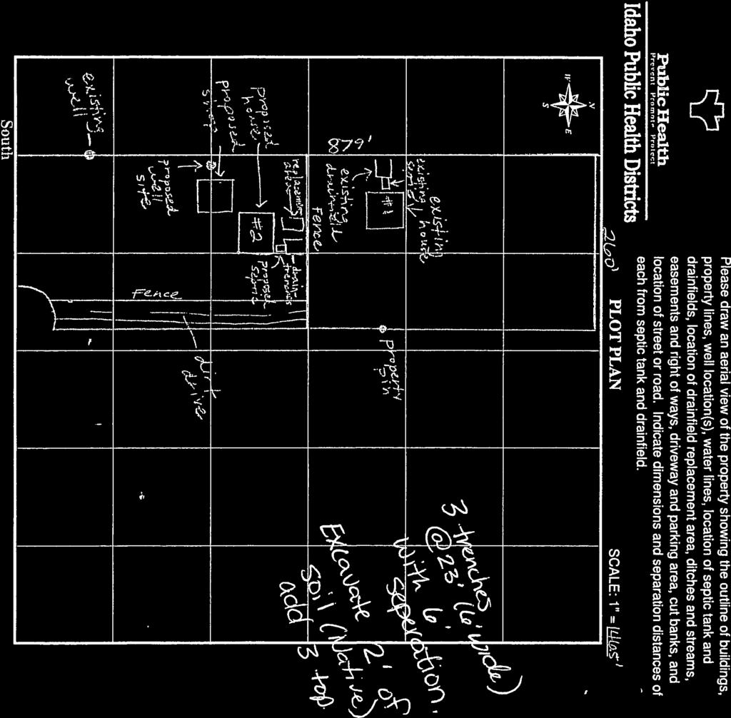
5 EXHIBIT 2 1 of 2 EXHIBIT 2 1 of 2


6 EXHIBIT 2 2 of 2 EXHIBIT 2 2 of 2


7 EXHIBIT 3 IMAGES WERE FLOWN IN THE FALL OF Kelley Dick Small Air Photo COMPASS EXHIBIT Miles
8 Exhibit 4 EXHIBIT 4
9 Exhibit 4 EXHIBIT 4

10 EXHIBIT 5 1 of 2 EXHIBIT 5 1 of 2

11 EXHIBIT 5 2 of 2 EXHIBIT 5 2 of 2
12 I LANSING LN PLS 8575 CPF LANSING LANE N 00 56'43" E ' /4 CORNER ILLEGIBLE RANCHERO DR VIC LN SITE STATE HWY 44 HONEY BEE CT VICINITY MAP SCALE: 1"=1000' STOFFLE LN BUMBLE BEE LN STOFFLE LN COX JANNAE RANCHERO DR S 89 46'35" W ' N 00 54'17" E ' ' ' ' N 89 47'48" E ' ' ' WEAVER DEANNA L RANCHERO DR STOFFLE LN 19 FOUND 1/2" PLS 3627, PULLED SET 5/8" PLS CRAIG DOUG RANCHERO DR GREENVIEW ACRES BOOK 18, PAGE 50 WYMAN TRAVIS A RANCHERO DR RUHMAN ROBERT AND LINDA FAMILY REV LIV TRUST 8875 VIC LN COMPHER BUDDY JR 8825 VIC LN 10.00' 37.68' FENDEL KRISTIN K RANCHERO DR WATER FLOW WATER FLOW N 00 54'17" E ' ' N 61 16'33" E 2427 S 85 28'22" E ' ' 20.00' WIDE PUID EASEMENT & SHARED WELL EASEMENT (THIS PLAT) N 79 57'25" W ' 2 N 37 11'16" W 16.32' WATER FLOW SHREINER ESTATES BOOK 25, PAGE 46 N 74 56'25" W Ac.± S 89 46'35" W ' 2.61 Ac.± N 17 31'53" W 37.95' ' BASIS OF BEARING EX. BLDG EX. BLDG BLOCK ' DRAINAGE EASEMENT BLOCK 1 EXISTING 10' WIDE PUID EASEMENT N 00 54'17" E ' ' N 73 18'41" W C1 FOUND 1/2" PLS 3627, PULLED SET 5/8" PLS C4 HEADGATE FENDEL KRISTIN FAMILY TRUST HONEY BEE CT GREENVIEW ACRES BOOK 18, PAGE ' S 89 46'35" E 97.90' SOUTH EDGE PRIVATE LATERAL EASEMENT 20.00' 10.00' MC REYNOLDS CLAYTON W 8865 VIC LN 60.12' OHP OHP C3 C2 S 00 54'17" W 4.54' WATER FLOW ' ' 46.96' ' HONEY BEE COURT (PRIVATE) S 01 20'20" W ' 1/16 CORNER PLS 3627 CPF S 00 54'17" W ' 50' RAD 39.70' WC 20.00' P.O.B ' INGRESS/ EGRESS & PUID EASEMENT (THIS PLAT) CORNWALL CAROL DEE HONEY BEE CT FOUND 1/2" PLS 3627, PULLED SET 5/8" PLS KELLY PATRICK STOFFLE LN ZAHLLER PAUL ROBERT REVOCABLE TRUST 8715 VIC LN S 89 46'35" W ' GREENVIEW ACRES BOOK 18, PAGE 50 LEMP PARK URBAN TRACTS BOOK 4, PAGE ' DRAINAGE EASEMENT 10.00' 17 WILLIAMS MARCY HONEY BEE CT HONEYCUTT KATHIE BUMBLE BEE LN UNPLATTED MARSTERS DOUG A 8740 HWY 44 PRELIMINARY PLAT OF HONEY BEE ACRES SUBDIVISION A REPLAT OF LOT 18, BLOCK 1, GREENVIEW ACRES SUBDIVISION LOCATED IN THE SW1/4 SW1/4 OF SECTION 3, AND THE NW1/4 NW1/4 OF SECTION 10, T. 4 N., R. 2 W., B.M., CANYON COUNTY, IDAHO 2018 PIERSON CATHLEEN E BUMBLE BEE LN JULIAN WILLIAM L BUMBLE BEE LN 1/4 CORNER PLS 1704 CPF PLAT NOTES OHP 1 PUID LEGEND BOUNDARY LINE LOT LINE CENTERLINE SECTIONAL LINE EASEMENT LINE OTHER LOT LINE OVERHEAD POWER LINE FENCE LINE FOUND BRASS CAP MONUMENT FOUND 5/8" REBAR PLS 3627 OR AS NOTED SET 1/2" REBAR/CAP PLS CALCULATED POINT LOT NUMBER TELEPHONE RISER POWER POLE DIRECTION OF LOT DRAINAGE PUBLIC UTILITY IRRIGATION & DRAINAGE EASEMENT CURVE TABLE CURVE ARC LENGTH RADIUS DELTA ANGLE CHORD BEARING CHORD LENGTH C ' 50.00' '21" S 22 32'58" W 92.95' C ' 20.00' 46 42'29" S 22 26'58" E 15.86' C ' 50.00' 73 44'23" S 54 01'57" W 60.00' C ' 50.00' 62 57'58" S 14 19'13" E 52.22' 80 SCALE ( FEET ) BOOK, PAGE INCH = 80 FT 1. ALL LOTS WITHIN THIS RE-PLAT ARE SUBJECT TO THE BY-LAWS OF GREENVIEW ACRES AS RECORDED IN INST. NOS , CANYON COUNTY RECORDS. 2. DOMESTIC WATER SHALL BE SUPPLIED BY SHARED WELL. SANITARY RESTRICTIONS FOR A SHARED WELL INSTALLATION SHALL BE SUBJECT TO APPROVAL OF SOUTHWEST DISTRICT HEALTH. 3. SEWAGE DISPOSAL SHALL BE BY INDIVIDUAL SEWER SEPTIC SYSTEMS. SANITARY RESTRICTIONS DESIGNATING AREAS RESERVED FOR CONSTRUCTION OF SEPTIC DRAINFIELDS SHALL BE SUBJECT TO APPROVAL BY SOUTHWEST DISTRICT HEALTH. 4. THIS RE-PLAT RECOGNIZES AND IS IN COMPLIANCE WITH IDAHO CODE (1)(b). LOTS WITHIN THIS RE-PLAT WILL RECEIVE GRAVITY IRRIGATION FROM AND ARE SUBJECT TO ASSESSMENTS FROM MIDDLETON MILL DITCH COMPANY 5. CANYON HIGHWAY DISTRICT NO. 4 WAIVES THE 70 FOOT SETBACK ALONG BOTH SIDES OF THE SECTION LINE COMMON TO SECTIONS 3 AND 10, WITHIN THE PLAT OF HONEY BEE ACRES SUBDIVISION. 6. THIS DEVELOPMENT RECOGNIZES SECTION OF IDAHO CODE RIGHT TO FARM ACT, WHICH STATES "NO AGRICULTURAL OPERATION, AGRICULTURAL FACILITY OR EXPANSION THEREOF SHALL BE OR BECOME A NUISANCE, PRIVATE OR PUBLIC, BY ANY CHANGED CONDITION IN OR ABOUT THE SURROUNDING NONAGRICULTURAL ACTIVITIES AFTER IT HAS BEEN IN OPERATION FOR MORE THAN ONE (1) YEAR, WHEN THE OPERATION, FACILITY OR EXPANSION WAS NO A NUISANCE AT THE TIME IT BEGAN OR WAS CONSTRUCTED. THE PROVISIONS OF THIS SECTION SHALL NOT APPLY WHEN A NUISANCE RESULTS FOR THE IMPROPER OR NEGLIGENT OPERATION OF AN AGRICULTURAL OPERATION, AGRICULTURAL FACILITY OR EXPANSION THEREOF." 7. LOTS 1 AND 2, BLOCK 1 ARE SUBJECT TO AN EXISTING WELL USERS AGREEMENT, AS RECORDED IN INST. NO.. 8. CURRENT ZONING FOR THIS SUBDIVISION C THIS DEVELOPMENT CONTAINS 5.25 AC±. 10. HISTORICAL DRAINAGE PATTERNS FOR THIS PROPERTY SHALL NOT CHANGE. NOTE Elevations are NAVD 88 FEMA NOTE This parcel lies within Zone X: per Map No C0254 F, effective date 5/24/2011. Zone X: Area of undetermined, but possible, flood hazard. EXHIBIT 6 1 of 4 OWNER/DEVELOPER: No. BY DATE REVISION DESCRIPTION 2030 S. WASHINGTON AVE. EMMETT, ID (208) F : ( 208 ) 1 AL 7/12/18 ADDRESS COUNTY COMMENTS REVISIONS ( 208 ) KELLEY DICK P : HONEY BEE ACRES SUB REPLAT OF LOT 18, BLOCK 1 OF GREENVIEW ACRES SW1/4 OF SEC. 3 & NW1/4 SEC. 10 T. 4 N., R. 2 W., B.M. CANYON CO., ID HONEY BEE CT (208) FAX (208) S AWTOOT H Land Surveying, LLC DRAWN BY: CHECKED BY: JB AL EXHIBIT 6 1 of 4 07/11/18 PREP DATE: DA HO EMMET T SHEET:, FP DRAWING # 1 OF 1
13 I PLS 8575 CPF LANSING LANE N 00 56'43" E ' /4 CORNER ILLEGIBLE ' S 89 46'35" W ' 19 GREENVIEW ACRES BOOK 18, PAGE FOUND 1/2" PLS 3627, PULLED SET 5/8" PLS ' N 00 54'17" E ' ' ' 59.37' ' 37.68' N 00 54'17" E ' EXISTING 10' PUID EASEMENT ' N 61 16'33" E N 89 47'48" E ' ' S 85 28'22" E ' ' 20.00' WIDE PUID EASEMENT & SHARED WELL EASEMENT (THIS PLAT) N 79 57'25" W ' 2 N 37 11'16" W 16.32' SHREINER ESTATES BOOK 25, PAGE 46 N 74 56'25" W Ac.± S 89 46'35" W ' 2.61 Ac.± N 17 31'53" W 37.95' EXISTING 10.00' PUID EASEMENT ' BASIS OF BEARING 25.00' DRAINAGE EASEMENT GREENVIEW ACRES BOOK 18, PAGE ' S 89 46'35" E N 00 54'17" E ' ' N 73 18'41" W C1 FOUND 1/2" PLS 3627, PULLED SET 5/8" PLS C ' SOUTH EDGE PRIVATE LATERAL EASEMENT 20.00' 10.00' 60.12' C3 C2 S 00 54'17" W 4.54' ' ' 60.00' INGRESS/ EGRESS & PUID EASEMENT (THIS PLAT) 46.96' ' HONEY BEE COURT (PRIVATE) S 01 20'20" W ' 1/16 CORNER PLS 3627 CPF S 00 54'17" W ' 50' RAD 39.70' WC 20.00' 20.00' DRAINAGE EASEMENT P.O.B ' FOUND 1/2" PLS 3627, PULLED SET 5/8" PLS LEMP PARK URBAN TRACTS BOOK 4, PAGE 32 S 89 46'35" W ' GREENVIEW ACRES BOOK 18, PAGE 50 UNPLATTED 17 PLAT OF HONEY BEE ACRES SUBDIVISION A REPLAT OF LOT 18, BLOCK 1, GREENVIEW ACRES SUBDIVISION LOCATED IN THE SW1/4 SW1/4 OF SECTION 3, AND THE NW1/4 NW1/4 OF SECTION 10, T. 4 N., R. 2 W., B.M., CANYON COUNTY, IDAHO /4 CORNER PLS 1704 CPF PLAT NOTES 1 PUID LEGEND CURVE TABLE CURVE ARC LENGTH RADIUS DELTA ANGLE CHORD BEARING CHORD LENGTH C ' 50.00' '21" S 22 32'58" W 92.95' C ' 20.00' 46 42'29" S 22 26'58" E 15.86' C ' 50.00' 73 44'23" S 54 01'57" W 60.00' C ' 50.00' 62 57'58" S 14 19'13" E 52.22' SCALE ( FEET ) 1 INCH = 80 FT BOUNDARY LINE LOT LINE CENTERLINE SECTIONAL LINE EASEMENT LINE OTHER LOT LINE FOUND BRASS CAP MONUMENT SET 5/8" REBAR/CAP PLS FOUND 5/8" REBAR PLS 3627 OR AS NOTED SET 1/2" REBAR/CAP PLS CALCULATED POINT LOT NUMBER PUBLIC UTILITY IRRIGATION & DRAINAGE EASEMENT 1. ALL LOTS WITHIN THIS RE-PLAT ARE SUBJECT TO THE BY-LAWS OF GREENVIEW ACRES AS RECORDED IN INST. NOS , CANYON COUNTY RECORDS. 2. DOMESTIC WATER SHALL BE SUPPLIED BY SHARED WELL. SANITARY RESTRICTIONS FOR A SHARED WELL INSTALLATION SHALL BE SUBJECT TO APPROVAL OF SOUTHWEST DISTRICT HEALTH. 3. SEWAGE DISPOSAL SHALL BE BY INDIVIDUAL SEWER SEPTIC SYSTEMS. SANITARY RESTRICTIONS DESIGNATING AREAS RESERVED FOR CONSTRUCTION OF SEPTIC DRAINFIELDS SHALL BE SUBJECT TO APPROVAL BY SOUTHWEST DISTRICT HEALTH. 4. THIS RE-PLAT RECOGNIZES AND IS IN COMPLIANCE WITH IDAHO CODE (1)(b). LOTS WITHIN THIS RE-PLAT ARE SUBJECT TO ASSESSMENTS FROM MIDDLETON MILL DITCH COMPANY 5. CANYON HIGHWAY DISTRICT NO. 4 WAIVES THE 70 FOOT SETBACK ALONG BOTH SIDES OF THE SECTION LINE COMMON TO SECTIONS 3 AND 10, WITHIN THE PLAT OF HONEY BEE ACRES SUBDIVISION. BOOK, PAGE. 6. THIS DEVELOPMENT RECOGNIZES SECTION OF IDAHO CODE RIGHT TO FARM ACT, WHICH STATES "NO AGRICULTURAL OPERATION, AGRICULTURAL FACILITY OR EXPANSION THEREOF SHALL BE OR BECOME A NUISANCE, PRIVATE OR PUBLIC, BY ANY CHANGED CONDITION IN OR ABOUT THE SURROUNDING NONAGRICULTURAL ACTIVITIES AFTER IT HAS BEEN IN OPERATION FOR MORE THAN ONE (1) YEAR, WHEN THE OPERATION, FACILITY OR EXPANSION WAS NO A NUISANCE AT THE TIME IT BEGAN OR WAS CONSTRUCTED. THE PROVISIONS OF THIS SECTION SHALL NOT APPLY WHEN A NUISANCE RESULTS FOR THE IMPROPER OR NEGLIGENT OPERATION OF AN AGRICULTURAL OPERATION, AGRICULTURAL FACILITY OR EXPANSION THEREOF." EXHIBIT 6 2 of 4 OWNER/DEVELOPER: No. BY DATE REVISION DESCRIPTION 2030 S. WASHINGTON AVE. EMMETT, ID (208) F : ( 208 ) 1 AL 7/12/18 ADDRESS COUNTY COMMENTS REVISIONS ( 208 ) KELLEY DICK P : TITLE: PLAT OF HONEY BEE ACRES LOCATED IN SW1/4 OF SEC. 3 & NW1/4 SEC. 10 T. 4 N., R. 2 W., B.M. CANYON CO., ID HONEY BEE CT (208) FAX (208) S AWTOOT H Land Surveying, LLC DRAWN BY: CHECKED BY: JB AL EXHIBIT 6 2 of 4 07/11/18 PREP DATE: DA HO EMMET T SHEET:, FP DRAWING # 1 OF 3
14 CERTIFICATE OF OWNERS KNOW ALL MEN BY THESE PRESENTS: THAT THE UNDERSIGNED, DO HEREBY CERTIFY THAT THEY ARE THE OWNERS OF THE REAL PROPERTY AS DESCRIBED BELOW AND IT IS THEIR INTENTION TO INCLUDE SAID PROPERTY IN THIS SUBDIVISION PLAT. THE EASEMENTS SHOWN ON THIS PLAT ARE NOT DEDICATED TO THE PUBLIC, BUT THE RIGHT TO USE SAID EASEMENTS IS HEREBY RESERVED FOR PUBLIC UTILITIES AND FOR ANY OTHER USES AS DESIGNATED HEREON, AND NO PERMANENT STRUCTURES ARE TO BE ERECTED WITHIN THE LINES OF SAID EASEMENTS. PURSUANT TO IDAHO CODE , WE THE UNDERSIGNED, DO HEREBY STATE THAT THE INDIVIDUAL LOTS SHOWN HEREON WILL BE SERVED BY A SHARED WATER SYSTEM COMMON TO MORE THAN ONE LOT. THE LOTS IN THIS SUBDIVISION ARE TO BE SERVED BY INDIVIDUAL SEPTIC SYSTEMS. THE STREET SHOWN HEREON (HONEY BEE COURT) IS A PRIVATE ROAD. A PARCEL OF LAND BEING ALL OF LOT 18, BLOCK 1 OF GREENVIEW ACRES, AS SHOWN IN BOOK 18 OF PLATS, AT PAGE 50, CANYON COUNTY, IDAHO, LOCATED IN THE SW 1/4 OF THE SW 1/4 OF SECTION 3, AND THE NW1/4 OF THE NW1/4 OF SECTION 10, T. 4 N., R. 2 W., B.M., CANYON COUNTY, IDAHO MORE PARTICULARLY DESCRIBED AS FOLLOWS: BEGINNING AT AN ALUMINUM CAP MARKING THE W1/16 CORNER COMMON TO SECTIONS 3 AND 10; THENCE SOUTH 0 54'17 WEST COINCIDENT WITH THE EAST BOUNDARY BOUNDARY LINE OF SAID LOT 18 OF GREENVIEW ACRES, FEET TO A 5/8 REBAR PLS 11574, MARKING THE NORTH RIGHT OF WAY LINE OF HONEY BEE COURT AND THE BEGINNING OF A NON-TANGENT CURVE TO THE LEFT ; THENCE COINCIDENT WITH THE NORTH AND WEST RIGHT OF WAY LINES OF HONEY BEE COURT, THE FOLLOWING COURSES AND DISTANCES: THENCE FEET COINCIDENT WITH ARC OF SAID CURVE, HAVING A CENTRAL ANGLE OF '21", A RADIUS OF FEET, SUBTENDED BY A CHORD WHICH BEARS, SOUTH 22 32'58 WEST, FEET TO A 5/8 REBAR PLS 11574, MARKING THE BEGINNING OF A REVERSE CURVE; THENCE FEET COINCIDENT WITH ARC OF SAID CURVE, HAVING A CENTRAL ANGLE OF 46 42'29", A RADIUS OF FEET, SUBTENDED BY A CHORD WHICH BEARS, SOUTH 22 26'58 EAST, FEET TO A 5/8 REBAR PLS 11574; THENCE SOUTH 0 54'17 WEST 4.54 FEET TO A FOUND 1/2" REBAR PLS 3627, PULLED AND RESET WITH A 5/8 REBAR PLS ON THE SOUTH BOUNDARY LINE OF SAID LOT 18, GREENVIEW ACRES; THENCE LEAVING SAID WEST RIGHT OF WAY LINE OF HONEY BEE COURT, NORTH 79 57'25 WEST, COINCIDENT WITH SAID SOUTH BOUNDARY LINE OF LOT 18, GREENVIEW ACRES, FEET TO THE SW CORNER OF SAID LOT 18, BLOCK 1, GREENVIEW ACRES, MARKED WITH A FOUND 1/2" REBAR PLS 3627, PULLED AND RESET WITH A 5/8 REBAR PLS 11574; THENCE NORTH 0 54'17 EAST, COINCIDENT WITH THE WEST BOUNDARY LINE OF SAID LOT 18, GREENVIEW ACRES, FEET TO THE NW CORNER OF SAID LOT 18, MARKED BY A 5/8 REBAR PLS 3627; THENCE NORTH 89 47'48 EAST, COINCIDENT WITH THE NORTH BOUNDARY LINE, FEET TO THE NE CORNER OF SAID LOT 18, GREENVIEW ACRES, WHICH BEARS NORTH 1 20'20" EAST, FEET FROM A 5/8" REBAR PLS 3627; THENCE SOUTH 1 20'20" WEST, COINCIDENT WITH THE EAST BOUNDARY LINE OF SAID LOT 18, GREENVIEW ACRES, FEET TO THE POINT OF BEGINNING; THE ABOVE DESCRIBED PARCEL CONTAINS 5.25 ACRES, MORE OR LESS. PLAT OF HONEY BEE ACRES SUBDIVISION A REPLAT OF LOT 18, BLOCK 1, GREENVIEW ACRES SUBDIVISION LOCATED IN THE SW1/4 SW1/4 OF SECTION 3, AND THE NW1/4 NW1/4 OF SECTION 10, T. 4 N., R. 2 W., B.M., CANYON COUNTY, IDAHO 2018 ACKNOWLEDGEMENT STATE OF IDAHO COUNTY OF CANYON ACKNOWLEDGEMENT STATE OF IDAHO COUNTY OF CANYON } } SS BOOK, PAGE. ON THIS DAY OF, 2018, BEFORE ME THE UNDERSIGNED A NOTARY PUBLIC IN AND FOR SAID STATE, PERSONALLY APPEARED JUDITH CAROL WALTER, KNOWN TO ME TO BE THE OWNER THAT EXECUTED THE INSTRUMENT AND ACKNOWLEDGED TO ME THAT SHE EXECUTED THE SAME. IN WITNESS WHEREOF, I HAVE HEREUNTO SET MY HAND AND SEAL THE DAY AND YEAR IN THIS CERTIFICATE FIRST ABOVE WRITTEN. NOTARY PUBLIC FOR IDAHO RESIDING AT MY COMMISSION EXPIRES: SS ON THIS DAY OF, 2018, BEFORE ME THE UNDERSIGNED A NOTARY PUBLIC IN AND FOR SAID STATE, PERSONALLY APPEARED KELLEY DEAN DICK AND CARRIE RENEE DICK, HUSBAND AND WIFE, KNOWN TO ME TO BE THE OWNERS THAT EXECUTED THE INSTRUMENT AND ACKNOWLEDGED TO ME THAT THEY EXECUTED THE SAME. IN WITNESS WHEREOF, I HAVE HEREUNTO SET MY HAND AND SEAL THE DAY AND YEAR IN THIS CERTIFICATE FIRST ABOVE WRITTEN. NOTARY PUBLIC FOR IDAHO RESIDING AT MY COMMISSION EXPIRES: EXHIBIT 6 3 of 4 OWNER/DEVELOPER: No. BY DATE REVISION DESCRIPTION 1 AL 7/12/18 ADDRESS COUNTY COMMENTS REVISIONS KELLEY DICK 2030 S. WASHINGTON AVE. EMMETT, ID (208) HONEY BEE CT (208) FAX (208) S AWTOOT H Land Surveying, LLC JUDITH CAROL WALTER KELLEY DEAN DICK CARRIE RENEE DICK CERTIFICATE OF SURVEYOR I, JEFF BEAGLEY, PLS, DO HEREBY CERTIFY THAT I AM A PROFESSIONAL LAND SURVEYOR LICENSED BY THE STATE OF IDAHO, AND THAT THIS PLAT AS DESCRIBED IN THE "CERTIFICATE OF OWNERS" WAS DRAWN FROM AN ACTUAL SURVEY MADE ON THE GROUND ON 04/16/2018 UNDER MY DIRECT SUPERVISION AND ACCURATELY REPRESENTS THE POINTS PLATTED THEREON, AND IS IN CONFORMITY WITH THE STATE OF IDAHO CODE RELATING TO PLATS, SURVEYS AND CORNER PERPETUATION AND FILING ACT, IDAHO CODE THROUGH JEFF BEAGLEY P.L.S TITLE: PLAT OF HONEY BEE ACRES LOCATED IN SW1/4 OF SEC. 3 & NW1/4 SEC. 10 T. 4 N., R. 2 W., B.M. CANYON CO., ID DRAWN BY: CHECKED BY: JB AL EXHIBIT 6 3 of 4 07/11/18 DATE: FP DRAWING # SHEET: 2 OF 3
15 I HEALTH CERTIFICATE SANITARY RESTRICTIONS AS REQUIRED BY IDAHO CODE, TITLE 50, CHAPTER 13 ARE IN FORCE. NO OWNER SHALL CONSTRUCT ANY BUILDING, DWELLING OR SHELTER WHICH NECESSITATES THE SUPPLYING OF WATER OR SEWER FACILITIES FOR PERSONS USING SAID PREMISES UNTIL SANITARY RESTRICTIONS ARE SATISFIED. SOUTHWEST DISTRICT HEALTH DEPARTMENT, EHS DATE CERTIFICATE OF COUNTY SURVEYOR I, THE UNDERSIGNED PROFESSIONAL LAND SURVEYOR FOR CANYON COUNTY, IDAHO, DO HEREBY STATE THAT I HAVE CHECKED THIS SUBDIVISION PLAT AND THAT IT IS IN COMPLIANCE WITH THE STATE OF IDAHO CODE, TITLE 50, CHAPTER 13, AND TITLE 55, CHAPTER 16, RELATING TO PLATS AND SURVEYS. DAVID R. KINZER PE/PLS 2659 DATE CERTIFICATION AND APPROVAL OF CANYON COUNTY HIGHWAY DISTRICT NO. 4 PLAT OF HONEY BEE ACRES SUBDIVISION A REPLAT OF LOT 18, BLOCK 1, GREENVIEW ACRES SUBDIVISION LOCATED IN THE SW1/4 SW1/4 OF SECTION 3, AND THE NW1/4 NW1/4 OF SECTION 10, T. 4 N., R. 2 W., B.M., CANYON COUNTY, IDAHO 2018 APPROVAL OF THE BOARD OF COUNTY COMMISSIONERS OF CANYON COUNTY ACCEPTED AND APPROVED THIS DAY OF,2018, BY THE BOARD OF CANYON COUNTY COMMISSIONERS OF CANYON COUNTY, IDAHO. CHAIRMAN DATE CERTIFICATE OF COUNTY TREASURER I, THE UNDERSIGNED, COUNTY TREASURER FOR CANYON COUNTY, STATE OF IDAHO, PER THE REQUIREMENTS OF I.C , DO HEREBY CERTIFY AND AFFIRM THAT THE PROPERTY TAX FOR THE PROPERTY DESCRIBED HEREIN IS PAID IN FULL THROUGH THE TAX YEAR. THE PROPERTY TAX LEVIED FOR THE TAX YEAR IS A LIEN DUE AND NOT YET PAYABLE. THIS CERTIFICATION IS VALID IF RECORDED WITHIN THIRTY (30) DAYS OF CERTIFICATION. CANYON COUNTY TREASURER DATE EXHIBIT 6 4 of 4 OWNER/DEVELOPER: No. BY DATE REVISION DESCRIPTION 2030 S. WASHINGTON AVE. EMMETT, ID (208) F : ( 208 ) 1 AL 7/12/18 ADDRESS COUNTY COMMENTS REVISIONS ( 208 ) KELLEY DICK P : HONEY BEE CT (208) FAX (208) S AWTOOT H Land Surveying, LLC DA HO EMMET T, CANYON HIGHWAY DISTRICT NO. 4. DOES HEREBY ACCEPT THIS PLAT, IN ACCORDANCE WITH THE PROVISIONS OF IDAHO CODE CHAIRMAN DATE CERTIFICATE OF COUNTY RECORDER TITLE: PLAT OF HONEY BEE ACRES LOCATED IN SW1/4 OF SEC. 3 & NW1/4 SEC. 10 T. 4 N., R. 2 W., B.M. CANYON CO., ID DRAWN BY: CHECKED BY: JB AL EXHIBIT 6 4 of 4 07/17/18 DATE: FP DRAWING # SHEET: 3 OF 3

 reviewed the referenced subdivision application and has the following comments: 1. This project does not abut the State highway system. 2.")
16 EXHIBIT 7 IDAHO TRANSPORTATION DEPARTMENT P.O. Box 8028 Boise, ID (208) itd.idaho.gov August 8, 2018 Kyle McCormick Canyon County Development Services 111 N. 11th Ave. Ste. 140 Caldwell, Idaho VIA Development Application Project Name SD HONEY BEE ACRES SUBDIVISION Project Location Honey Bee Court, north of SH-44 milepost 6.68 Project Description Applicant Preliminary and final plat for Honey Bee Acres Subdivision, replat of Lot 18 Block 1 of Greenview Acres Subdivision, consisting of 2 lots Kelley Dick The Idaho Transportation Department (ITD) reviewed the referenced subdivision application and has the following comments: 1. This project does not abut the State highway system. 2. The access to this parcel is permitted under ITD Permit No Idaho Code does not allow advertising within the right-of-way of any State highway. 4. IDAPA rules govern advertising along the State highway system. The applicant may contact Justin Pond, Right-of-Way Section Program Manager, at (208) for more information. 5. ITD does not object to the preliminary and final plat for Honey Bee Acres Subdivision as presented in the application. If you have any questions, you may contact Tom Haynes at (208) or me at (208) Sincerely, Ken Couch Development Services Coordinator Ken.Couch@itd.idaho.gov EXHIBIT 7
17 EXHIBIT 8 EXHIBIT 8
18 EXHIBIT 9 EXHIBIT 9


19 EXHIBIT 10 EXHIBIT 10
Radford Ridges Subdivision, SD-PH
 / Planning and Zoning Staff Report Radford Ridges Subdivision, SD-PH2017-22 Hearing Date: August 3, 2017 Development Services Department Applicant: James Radford Representative: TJ Wellard Skinner Land
AAAA. Planning and Zoning Staff Report Lake Shore Land Holdings, LLC CU-PH Analysis
 AAAA Planning and Zoning Staff Report Lake Shore Land Holdings, LLC CU-PH2016-28 Hearing Date: April 21, 2016 Development Services Department Applicant: BRS Architects/Cindy Huebert Staff: Kyle McCormick,
Ricker - PH / Planning and Zoning Commission Staff Report
 / Planning and Zoning Commission Staff Report Ricker - PH2018-20 Hearing Date: April 19, 2018 Development Services Department Applicant: Don Ricker Staff: Dan Lister, Planner II dlister@canyonco.org Tax
Bethel Romanian Church - Rezone, RZ
 / Planning and Zoning Staff Report Bethel Romanian Church - Rezone, RZ2018-0023 Hearing Date: November 15, 2018 Development Services Department Owners: Bethel Romanian Church, Corp. Applicant: Viorel Botos
Oakland County Michigan Register of Deeds Plat Engineering, GIS, & Remonumentation Dept. Ph: (248) Fax (248)
 Fax (248)") Oakland County Michigan Register of Deeds Plat Engineering, GIS, & Remonumentation Dept. Ph: (248)-858-1447 Fax (248)-858-7466 Requirements Needed for Final Plat Approval No. General Requirements. 1 Routing
Oakland County Michigan Register of Deeds Plat Engineering, GIS, & Remonumentation Dept. Ph: (248)-858-1447 Fax (248)-858-7466 Requirements Needed for Final Plat Approval No. General Requirements. 1 Routing
The Filing Fee for a Minor Plat is $ PLUS $20.00 per lot created
 DEPARTMENT OF COMMUNITY DEVELOPMENT MINOR PLAT PROCEDURE The Filing Fee for a Minor Plat is $250.00 PLUS $20.00 per lot created Description: The purpose of a Minor Plat is to allow property to be platted
MINOR PLAT FILING APPLICATION
 FILING APPLICATION Date of PC Meeting: Date of BCC Meeting: Fee Paid: 1. APPLICANT: DAYTIME PHONE: MAILING ADDRESS: LANDOWNER: DAYTIME PHONE: MAILING ADDRESS: AUTHORIZED AGENT: MAILING ADDRESS: RELATIONSHIP
Planning and Zoning Staff Report Vallivue School District - PH
 Hearing Date: April 19, 2018 Planning and Zoning Staff Report - PH2018-16 Development Services Department Applicant: Nate Bondelid Owner: Staff: Dan Lister, Planner II (208) 455-5959 dlister@canyonco.org
Final Plat Mapping Requirements
 CURRENT PLANNING DIVISION 410 E. 5 th Street Loveland, CO 80537 970-962-2523 eplan-planning@cityofloveland.org cityofloveland.org/dc Final Plat Mapping Requirements All Final plats shall comply with the
Preliminary Plat/Final Plat Application
 Melissa Municipal Center 3411 Barker Avenue Melissa, Texas 75454 Phone: (972) 838-2036 Applicant: Date: Address: Phone: Contact: Fax: E-mail: Propose Addition Name: Acres: Existing Zoning: Propose Zoning:
APPENDIX C: PLAT SPECIFICATIONS AND CERTIFICATES
 APPENDIX C: PLAT SPECIFICATIONS AND CERTIFICATES A. Drawing. All plats for recording must be submitted on photographically reproducible and dimensionally stable polyester sheets such as Mylar, Cronar or
ABBREVIATION LEGEND SITE INFORMATION:
 SITE INFORMATION: Current Zone: R-3 PUD, governed by Fox Hollow 2nd MDA Basis of Elevations: Northeast Corner of Section 13, T6S, R1W, S.L.B. & M Elevation: 4599.26 (Benchmark) ABBREVIATION LEGEND Owners:
SUBMITTAL REQUIREMENTS: The number indicates the number of copies for submittal (if applicable).
.") Office Use Only Preliminary Long Plat Long Subdivision Applicant Checklist PLANNING, COMMUNITY, & ECONOMIC DEVELOPMENT DEPARTMENT FINAL LONG PLAT LONG SUBDIVISION CHECKLIST Mailing Address: P.O. Box 547,
Office Use Only Preliminary Long Plat Long Subdivision Applicant Checklist PLANNING, COMMUNITY, & ECONOMIC DEVELOPMENT DEPARTMENT FINAL LONG PLAT LONG SUBDIVISION CHECKLIST Mailing Address: P.O. Box 547,
SUBDIVISION APPLICATION
 STAFF USE ONLY Date Submitted: Received by: Fee paid: Project # REQUIRED SUBMITTALS Application Fee: $600.00 (up to 5 lots) + $50.00 (per lot above 5) Publication Fee: $300.00 Mailing Fee: $6.00 per hearing
BOSSIER CITY PARISH METROPOLITAN PLANNING COMMISSION 620 Benton Rd. Bossier City, LA Phone: Fax: PRELIMINARY PLAT
 (OFFICE USE ONLY) Application Fee: Paid: Date: CASE # Project Information BOSSIER CITY PARISH METROPOLITAN PLANNING COMMISSION 620 Benton Rd. Bossier City, LA 71111 Phone: 318-741-8824 Fax: 318-741-8827
PLANNING DIRECTOR. Approved by the Planning Director on this day of, A.D. 20. day of, A.D. 20. Approved by the Fire Chief on this
 Located in a portion of the West Half of Section 19, Township 5 South, Range 1 East, Salt Lake Base and Meridian. SURVEYOR'S CERTIFICATE I, the undersigned surveyor, do hereby certify that I am a registered
SUBMITTAL REQUIREMENTS: The number indicates the number of copies for submittal (if applicable).
.") Office Use Only Preliminary Long Plat Long Subdivision Applicant Checklist PLANNING, COMMUNITY, & ECONOMIC DEVELOPMENT DEPARTMENT PRELIMINARY LONG PLAT LONG SUBDIVISION CHECKLIST Mailing Address: P.O.
Office Use Only Preliminary Long Plat Long Subdivision Applicant Checklist PLANNING, COMMUNITY, & ECONOMIC DEVELOPMENT DEPARTMENT PRELIMINARY LONG PLAT LONG SUBDIVISION CHECKLIST Mailing Address: P.O.
Planning and Zoning Staff Report Maverick Towers Van Wassenhove, PH
 Planning and Zoning Staff Report Maverick Towers Van Wassenhove, PH2018-17 Hearing Date: April 19, 2018 Development Services Department Applicant: Maverick Towers - Nadine Bostwick Owner: Paul Van Wassenhove
Synergy Park Addition (Companion to item 3)
") Synergy Park Addition (Companion to item 3) Attachments: 1. Locator 2. Replat staff report 3. Replat W P G r es rg eo e s Bu hh wy Lot 6A 4.02-acres Lot 4C 13.02-acres Fran k Lots 4C and 6A, Block A Synergy
Synergy Park Addition (Companion to item 3) Attachments: 1. Locator 2. Replat staff report 3. Replat W P G r es rg eo e s Bu hh wy Lot 6A 4.02-acres Lot 4C 13.02-acres Fran k Lots 4C and 6A, Block A Synergy
/ Planning and Zoning Commission Staff Report Jay Walker- All Terra Consulting - RZ
 / Planning and Zoning Commission Staff Report Jay Walker- All Terra Consulting - Hearing Date: January 17, 2019 Development Services Department Applicant: Jay Walker All Terra Consulting Staff: Jennifer
Time Extension Staff Report
 Time Extension Staff Report Subdivision Name Lunara Subdivision File Number SUB07-00019 Approval Time Extension for Lead Agency Boise City Certification Signature of Boise City Engineer Annexation Date
FINAL PLAT. Community Development Department 8101 Ralston Road Arvada, Colorado 80002
 FINAL PLAT Community Development Department 8101 Ralston Road Arvada, Colorado 80002 September 2015 FINAL SUBDIVISION PLAT Final Subdivision Plat Review Applications for a Final Plat shall be submitted
Planning and Zoning Commission Staff Report Shannan & Latrica Mays -Conditional Use Permit - CU
 Planning and Zoning Commission Staff Report Shannan & Latrica Mays -Conditional Use Permit - Hearing Date: January 17, 2019 Development Services Department Applicant: Shannan & Latrica Mays Staff: Jennifer
FINAL PLAT APPLICATION
 FINAL PLAT APPLICATION (Page 1 of 3) LEGAL OWNER(s): NAME: STREET ADDRESS OWNER(s): CITY, STATE, ZIP CODE: PHONE NUMBER: BILLING ADDRESS: NAME OF ENGINEER/SURVEYOR: Engineer/Surveyor Address, Phone: PROPERTY
ADMINISTRATIVE HEARING STAFF REPORT Country Club Acres Second Amended Subdivision Amendment PLNSUB E Parkway Avenue December 12, 2013
 ADMINISTRATIVE HEARING STAFF REPORT Country Club Acres Second Amended Subdivision Amendment PLNSUB2013-00925 2167 E Parkway Avenue December 12, 2013 Planning Division Department of Community & Economic
Planning and Zoning Staff Report Pestcom Pest Management LLC CU-PH
 AAAA Planning and Zoning Staff Report Pestcom Pest Management LLC CU-PH2016-49 Hearing Date: October 6, 2016 Development Services Department Applicant: Charles F. Cooley Sr. Pestcom Pest Management LLC
Submittal Requirements: Subdivision Plat (Final)
") s Planning and Zoning Submittal Requirements: Subdivision Plat (Final) 1. Application form, APO fees, and filing fee. Transportation Development Review Fee please contact Engineering at (970) 221-6605
s Planning and Zoning Submittal Requirements: Subdivision Plat (Final) 1. Application form, APO fees, and filing fee. Transportation Development Review Fee please contact Engineering at (970) 221-6605
Mike & Sherry Dudley Rezone, RZ
 / Planning and Zoning Staff Report Mike & Sherry Dudley Rezone, RZ2019-0005 Hearing Date: April 18, 2019 Development Services Department Applicant: Mike & Sherry Dudley Staff: Deb Root, 454-7340 droot@canyonco.org
Planning Commission Application Summary
 Planning Commission Application Summary Project Name: Academy Office Park Plat Amendment Request Address: 339 West 13490 South Current Zoning: CSD-DPMU Hearing Date: August 11, 2016 Summary of Request
Tracie & Dennis Jones Rezone, RZ
 / Planning and Zoning Staff Report Tracie & Dennis Jones Rezone, RZ2018-0014 Applicant: Tracie & Dennis Jones Staff: Deb Root, 454-7340 droot@canyonco.org Tax ID: R37886012 Current Zone: A (Agricultural)
MINOR SUBDIVISION INFORMATION
 A. POINTS OF CONTACT: MINOR SUBDIVISION INFORMATION Surveyor: Address: Phone #: Fax # E-Mail Address: Representative (If different from applicant): Address: Phone #: Fax # E-Mail Address: B. GENERAL INFORMATION:
CERTIFIED SURVEY MAP
 SCONSIN STATE PLANE N:389676.12 E:2130390.15 Center of Section 23 CERTIFIED SURVEY MAP 734.06' THE (PRITCHETTE) ORIGINAL PLAT OF ALL IN THE NW 1 4 OF THE SE 1 4 OF FRACTIONAL SECTION 23, T7N, R9E, IN THE
Time Extension Staff Report
 Time Extension Staff Report Subdivision Name Therrin Subdivision File Number SUB06-00020 Approval Time Extension for Lead Agency Boise City Certification Signature of Boise City Engineer Annexation Date
Planning and Zoning Staff Report JT Ventures, LLC Staging Area, CU-PH
 Planning and Zoning Staff Report JT Ventures, LLC Staging Area, CU-PH2016-60 Hearing Date: December 15, 2016 Development Services Department Applicant: JT Ventures, LLC Jason Stewart and Tony Brown Staff:
QUEBEC STREET EAST 130TH AVENUE ONEIDA STREET E. 130TH AVE. VALENTIA ST TAMARAC ST EAST 128TH AVENUE MOACO STREET BACHMAN DR. SITE QUINCE ST.
 SHEET OF CASE NO.: SUBA - PURPOSE STATEMENT: THIS PLAT IS INTENDED TO SUBDIVIDE. ACRES INTO SINGLE FAMILY LOTS, AND TRACTS FOR PARKS, OPEN SPACE, DRAINAGE AND DETENTION, DEDICATE RIGHT-OF-WAY AND GRANT
LAND USE PERMIT APPLICATION
 LAND USE PERMIT APPLICATION Date Application No. TYPE OF PERMIT Subdivision Short Plat Conditional Use Binding Site Plan Final Plat Final Short Plat Variance Final Binding Site Plan Plat Amendment Short
QUEBEC STREET EAST 130TH AVENUE ONEIDA STREET E. 130TH AVE. VALENTIA ST TAMARAC ST EAST 128TH AVENUE MONACO STREET BACHMAN DR. SITE QUINCE ST.
 SHEET OF CASE NO.: SUBA 0-0 PURPOSE STATEMENT: THIS PLAT IS INTENDED TO SUBDIVIDE. ACRES INTO 0 SINGLE FAMILY LOTS, AND TRACTS FOR PARKS, OPEN SPACE, DRAINAGE AND DETENTION, DEDICATE RIGHT-OF-WAY AND GRANT
Planning and Zoning Staff Report for Serenity Hill Ranch - PH
 Hearing Date: March 1, 2018 Planning and Zoning Staff Report for Serenity Hill Ranch - Development Services Department Applicant: Serenity Hill Ranch Staff: Jennifer Almeida, 455-5957 jalmeida@canyonco.org
AGENDA ITEM G-2 Public Works
 AGENDA ITEM G-2 Public Works STAFF REPORT City Council Meeting Date: 2/23/2016 Staff Report Number: 16-035-CC Consent Calendar: Adopt a resolution accepting Easements and approving the abandonment of two
MAJOR RESIDENTIAL AND NONRESIDENTIAL SUBDIVISIONS
 MAJOR RESIDENTIAL AND NONRESIDENTIAL SUBDIVISIONS Final Plats The applicant shall schedule a Pre-Application meeting with Planning Staff at least seven (7) working days prior to submittal of the application.
COUNCIL AGENDA MEMO ITEM NO. III - #1
 COUNCIL AGENDA MEMO ITEM NO. III - #1 FROM: Anton Jelinek, Director of Utilities MEETING: October 24, 2017 SUBJECT: PRESENTER: Permanent Utility and Right-of-Way Easement Anton Jelinek Discussion: At the
VICINITY MAP SCALE 1'' = 2000'
 CITY CREEK ANNEXATION TO THE CITY OF THORNTON LOCATED IN THE SOUTHWEST QUARTER OF SECTION 11 AND THE WEST HALF OF SECTION 14, TOWNSHIP 1 SOUTH, RANGE 68 WEST OF THE 6TH PRINCIPAL MERIDIAN, COUNTY OF ADAMS,
PLANNING AND DEVELOPMENT DEPARTMENT PRELIMINARY PLAT APPLICATION
 PLANNING AND DEVELOPMENT DEPARTMENT PRELIMINARY PLAT APPLICATION IT IS INCUMBENT UPON THE APPLICANT TO SUBMIT COMPLETE AND CORRECT INFORMATION. ANY MISLEADING, DECEPTIVE, INCOMPLETE OR INCORRECT INFORMATION
SUBDIVISION PLAT CHECKLIST. The following information shall be include on the plat:
 SUBDIVISION PLAT CHECKLIST Subdivision Name: Land Surveyor: Owner/Developer: Date Submitted: The following information shall be include on the plat: The plat shall be drawn at a scale of one inch equals
PLANNING COMMISSION REPORT Non-Public Hearing Item
 PC Staff Report 09/21/2015 Item No. 2B - 1 PLANNING COMMISSION REPORT Non-Public Hearing Item PC Staff Report 09/212015 ITEM NO. 2B: FINAL PLAT FOR MORGAN ADDITION; 800 MONTEREY WAY (MKM) : Consider a
Planning and Zoning Staff Report Meholchick Juniper Ranch, CU
 Applicant: Stan and Jeanie Meholchick Juniper Ranch Staff: Deb Root droot@canyonco.org Tax ID, Acres: R34083 (10.09 acres) Current Zone: A (Agriculture) Current Use: Rural Residential home site Impact
FINAL PLAT GUIDE TO SUBDIVIDING PROPERTY. Background
 FINAL PLAT GUIDE TO SUBDIVIDING PROPERTY Background A final plat is the second step in the process of subdividing land into separate parcels for future sale or lease. Once a preliminary plat has been approved
E. 140TH AVE. VICINITY MAP SCALE: 1"=600' LAND USE TABLE NET AREA 599,946 SQFT AC. GROSS AREA 741,420 SQFT AC.
 SHEET OF PURPOSE STATEMENT: THIS PLAT IS INTENDED TO SUBDIVIDE. ACRES INTO SINGLE FAMILY ATTACHED LOTS, TRACTS, DEDICATE AND GRANT EASEMENTS. LEGAL DESCRIPTION: THE UNDERSIGNED BEING THE OWNER(S) OF A
MINOR SUBDIVISION PLAT
 MINOR SUBDIVISION PLAT Community Development Department 8101 Ralston Road Arvada, Colorado 80002 MINOR SUBDIVISION PLAT Subdivisions consisting of five (5) or fewer lots are eligible for the minor subdivision
USE BY SPECIAL REVIEW HOULIHAN PIPELINE PROJECT 5 OF 6 6 OF 6 E. CO RD 6 / E. 6TH AVE. S. CO RD113 / S. MANILLA RD.
 USE BY SPECIAL REVIEW LOCATED IN SECTIONS, 4,,, &, TOWNSHIP 4 SOUTH RANGE 64 WEST OF THE 6TH P.M. 1 4 STANDARD NOTES THE OPERATOR, OF THE PROJECT KNOWN AS, THEIR RESPECTIVE SUCCESSORS, HEIRS AND/OR ASSIGNS
Sketch & Legal Description of Mitigation Bank and Ingress/Egress Access Easements
 Appendix H: Sketch & Legal Description of Mitigation Bank and Ingress/Egress Access Easements Tippen Bay Wetland Mitigation Bank DeSoto County, Florida Prepared by: September, 2017 Original file
MINOR SUBDIVISION PLAT
 MINOR SUBDIVISION PLAT Community Development Department 8101 Ralston Road Arvada, Colorado 80002 September 2015 MINOR SUBDIVISION PLAT Subdivisions consisting of five (5) or fewer lots are eligible for
SUBDIVISION APPLICATION: RECOMBINATION PLAT or EXEMPT PLAT
 SUBDIVISION APPLICATION: RECOMBINATION PLAT or EXEMPT PLAT Pursuant to Article 7, Section 155.706 of the Unified Development Code, an owner of land within the jurisdiction of the Town (or a duly authorized
NO DEED OF RESTRICTIONS CANYON SPRINGS RESORT, INC. TO THE PUBLIC. COUNTY OF COMAL KNOW ALL MEN BY THESE PRESENTS:
 UNITS I, II, AND III NO. 62100 DEED OF RESTRICTIONS CANYON SPRINGS RESORT, INC. TO THE PUBLIC. THE STATE OF TEXAS COUNTY OF COMAL KNOW ALL MEN BY THESE PRESENTS: That CANYON SPRINGS RESORT, INC., a Corporation
COUNTY OF ADAMS, STATE OF COLORADO E. 40TH AVE. TOWER RD. E. 38TH AVE. SALIDA ST. HIGH LINE CANAL PROJECT LOCATION E. 32ND PKWY.
 LEGAL DESCRIPTION:, GATEWAY EAST AT TOWER SUBDIVISION FILING NO. 1, SAID PARCEL CONTAIN 598,154 SQUARE FEET OR MORE OR LESS GENERAL NOTES: 1. NOTICE: ACCORDING TO COLORADO LAW YOU MUST COMMENCE ANY LEGAL
CITY OF LEE S SUMMIT MINOR PLAT PROCESS. Purpose of Minor Plats
 MINOR PLAT PROCESS Purpose of Minor Plats The City of Lee s Summit requires that all property be platted before a building permit is issued. Platting involves the subdivision of land into lots or tracts.
Request for Action form is also defined as an application to be considered by the Planning Commission.
 CITY OF NORTH RIDGEVILLE INSTRUCTIONS FOR FILING REQUEST FOR ACTION APPLICATIONS WITH THE PLANNING COMMISSION (Please read the full instruction as it will help in providing a full complete application)
LISA ANDERSON-OGILVIE, AICP DEPUTY COMMUNITY DEVELOPMENT DIRECTOR AND PLANNING ADMINISTRATOR
 FOR MEETING OF: December 12, 2018 CASE NO.: VUL18-01 TO: FROM: HEARINGS OFFICER LISA ANDERSON-OGILVIE, AICP DEPUTY COMMUNITY DEVELOPMENT DIRECTOR AND PLANNING ADMINISTRATOR SUBJECT: VALIDATION OF UNIT
Boundary Line Adjustment Application
 Boundary Line Adjustment Application A COMPLETE APPLICATION is required at the time of submittal. REQUIRED SUBMITTALS: 1. Application form 2. Application Fee - $500.00. 3. Current title report 4. Three
Township of Collier 2418 Hilltop Road Presto, PA 15142
 Township of Collier 2418 Hilltop Road Presto, PA 15142 Fees: Major: 2 checks $600 + $50 per lot & $1700 Escrow) APPLICATION FOR SUBDIVISION major FINAL only Plans must be folded Rolled plans will not be
Township of Little Egg Harbor Planning Board 665 Radio Road Little Egg Harbor, New Jersey Phone: ext. 221 Fax:
 BLOCK(S) LOT(S) Township of Little Egg Harbor Planning Board 665 Radio Road Little Egg Harbor, New Jersey 08087 Phone: 609-296-7241 ext. 221 Fax: 609-294-3040 Development Application Amended Development
NOT TO BE SUBMITTED WITH SKETCH DESIGN APPROVAL Subdivision Checklist: Major Subdivision Final Plat
 Must be received with review fee (equal to $200.00, plus $25.00 per lot) no later than 15 days prior to Planning Board meeting, which is normally the first Monday of the month (certain holidays may modify
PRELIMINARY PLAT Checklist
 PRELIMINARY PLAT Checklist 3715 Bridgeport Way W University Place, WA 98466 PH: (253) 566-5656 FAX: (253) 460-2541 This is a checklist of materials required for a Preliminary Plat. This checklist is provided
Group Sewer Only** 80 Ft Frontage* 20,000 Sq. Ft. (.46 acre) Minimum** 120 Ft Frontage* 20,000 Sq. Ft. (.46acre) Minimum** 150 Ft Frontage*
 Minimum** 120 Ft Frontage* 20,000 Sq. Ft. (.46acre) Minimum** 150 Ft Frontage*") Residential Lots Minimum Chart The minimum lot size of any minor subdivision where there is no public sewers shall be as shown below or as required by township zoning and/or the Tuscarawas General Health
Residential Lots Minimum Chart The minimum lot size of any minor subdivision where there is no public sewers shall be as shown below or as required by township zoning and/or the Tuscarawas General Health
Preliminary Subdivision Application (Major) (Four (4) lots or more)
 (Four (4) lots or more)") Gunnison City Offices www.gunnisoncity.org 38 West Center Gunnison, Utah 84634 (435) 528 7969 Date of Application: Preliminary Subdivision Application (Major) (Four (4) lots or more) APPLICANT INFORMATION
Gunnison City Offices www.gunnisoncity.org 38 West Center Gunnison, Utah 84634 (435) 528 7969 Date of Application: Preliminary Subdivision Application (Major) (Four (4) lots or more) APPLICANT INFORMATION
MINOR SUBDIVISION PLAT CHECKLIST
 MINOR SUBDIVISION PLAT CHECKLIST Project Name: Tax ID #: Project Number: Date: _ Reviewed By: Telephone: NOTES: All lots on septic systems must comply with the Fulton County Health Department requirements
Community Development Department Council Chambers, 7:30 PM, December 1, 2016
 STAFF REPORT 2016-35P: Subdivision Community Development Department Council Chambers, 7:30 PM, December 1, 2016 To: From: Re: Paul Luke, Chairman, Skokie Plan Commission Mike Voitik, Planning Technician
APPLICATION PROCEDURE
 ANTRIM PLANNING BOARD P. O. Box 517 Antrim, New Hampshire 03440 Phone: 603-588-6785 FAX: 603-588-2969 APPLICATION FORM AND CHECKLIST FOR MINOR OR MAJOR SITE PLAN REVIEW File Date Received By APPLICATION
MINOR PLAT AMENDMENT APPLICATION CHECK APPLICABLE PERMIT ATTACHMENT:
 240 East Gammon Road Vineyard, Utah 84058 (801) 226-1929 MINOR PLAT AMMENDMENT APPLICATION Please Note: Attachment of request specific documents is required prior to processing your application. APPLICATION
Community Development Department Council Chambers, 7:30 PM, July 20, 2017
 STAFF REPORT 2017-25P: Subdivision Community Development Department Council Chambers, 7:30 PM, July 20, 2017 To: From: Re: Paul Luke, Chairman, Skokie Plan Commission Mike Voitik, Planning Technician 2017-25P:
RIGHT OF WAY AND COMMON DRIVEWAY AGREEMENT SUN8 PDC, LLC, c/o DISTRIBUTED SUN, LLC SUBDIVISION DRYDEN, NEW YORK
 RIGHT OF WAY AND COMMON DRIVEWAY AGREEMENT SUN8 PDC, LLC, c/o DISTRIBUTED SUN, LLC SUBDIVISION DRYDEN, NEW YORK THIS RIGHT OF WAY AGREEMENT ( Agreement ) is made this day of, 2017 by SCOTT PINNEY, an individual
STANDARD LANGUAGE FORMAT GUIDE PLANNING SERVICES DIVISION
 A. OWNERSHIP CERTIFICATE The purpose of the ownership certificate is to identify the owner and provide the Volume and Page of Deed Records, verifying the ownership. When the property owner is a corporation,
COUNTY OF ALBEMARLE APPLICATION FOR RURAL SUBDIVISION
 Page 1 APPLICATION FOR RURAL SUBDIVISION The term rural subdivision means a type of subdivision that is located in the rural areas which results in two or more lots for the purpose of transfer of ownership
APPLICATION FOR FINAL PLAT APPROVAL (Major Subdivision)
") APPLICATION FOR FINAL PLAT APPROVAL (Major Subdivision) CITY OF HOSCHTON, GA PLANNING AND DEVELOPMENT 79 City Square Hoschton, GA 30548 706-654-3034 Applicant Information: Name: Address: City, State, Zip:
APPLICATION FOR FINAL PLAT APPROVAL (Major Subdivision) CITY OF HOSCHTON, GA PLANNING AND DEVELOPMENT 79 City Square Hoschton, GA 30548 706-654-3034 Applicant Information: Name: Address: City, State, Zip:
ARTICLE 900 PLAT AND PLAN REQUIREMENTS
 ARTICLE 900 PLAT AND PLAN REQUIREMENTS SEC. 900.1 ITEMS TO BE SHOWN ON PLAT OR PLAN General (1) Property lines of all property owners adjacent to the exterior boundaries of the project shall be located
PUD Ordinance - Cascade Lakes Plat #10 of 1995
 PUD Ordinance - Cascade Lakes Plat #10 of 1995 CASCADE CHARTER TOWNSHIP Ordinance #10 of 1995 AN ORDINANCE TO AMEND THE CASCADE CHARTER TOWNSHIP ZONING ORDINANCE AND ZONING MAP TO ESTABLISH THE CASCADE
PRELMINARY PLAT CHECKLIST
 PRELMINARY PLAT CHECKLIST A. All preliminary plat submitted for approval shall be prepared by a Registered Professional Land Surveyor. B. Preliminary plats must be drawn to a scale of XXX with such accuracy
STANDARDIZED LEGAL DESCRIPTIONS AND EXHIBITS
 STANDARDIZED LEGAL DESCRIPTIONS AND EXHIBITS Public Works Department, Engineering Division June 14, 2004 UNIFIED GOVERNMENT STANDARDIZED LEGAL DESCRIPTIONS AND EXHIBITS For: Roads, Bridges, Short Span
Regular Agenda / Public Hearing for Board of Commissioners meeting January 7, 2015
 Rebecca W. Arnold, Commissioner Sara M. Baker, Commissioner Jim D. Hansen, Commissioner Kent Goldthorpe, Commissioner Paul Woods, Commissioner TO: FROM: ACHD Board of Commissioners & Bruce S. Wong, Director
APPLICATION FOR FINAL PLAT APPROVAL
 APPLICATION FOR FINAL PLAT APPROVAL Section 1. General. The undersigned Applicant (Applicant is synonymous with owner) makes this Application for Final Plat Approval in accordance with Chapter 21, Port
CITY OF BEVERLY HILLS Department of Public Works and Transportation Civil Engineering Division FINAL MAP SUBMITTAL PROCESS Transmitted
 CITY OF BEVERLY HILLS Department of Public Works and Transportation Civil Engineering Division FINAL MAP SUBMITTAL PROCESS Transmitted From To* Planning Department Civil Engineering Division RKA Consulting
CHAPTER SHORT SUBDIVISIONS
 CITY OF MOSES LAKE MUNICIPAL CODE CHAPTER 17.09 SHORT SUBDIVISIONS Sections: 17.09.010 Purpose 17.09.020 Scope 17.09.030 Preliminary Short Subdivision Conditions and Requirements 17.09.040 Referral to
SUBDIVISION APPLICATION INSTRUCTIONS
 SUBDIVISION APPLICATION INSTRUCTIONS APPLICATION FORM The application form must be fully completed, signed by the property owner and shall be properly notarized. AGENT AUTHORIZATION FORM If the applicant
WATERFORD LANDING COMMUNITY DEVELOPMENT DISTRICT REGULAR MEETING AGENDA
 WATERFORD LANDING COMMUNITY DEVELOPMENT DISTRICT REGULAR MEETING AGENDA January 31, 2019 Waterford Landing Community Development District OFFICE OF THE DISTRICT MANAGER 2300 Glades Road, Suite 410W Boca
City of Grand Forks Staff Report
 City of Grand Forks Staff Report Planning and Zoning Commission March 6, 2019 City Council March 18, 2019 Agenda Item: 4-1 (Preliminary) Preliminary approval of the plat of University Place First Resubdivision
A Final Plat will be reviewed concurrently with any other development review application(s) that is required.
 that is required.") RELATED FACTS TO KNOW: Adams County Recording Requirements, Annexation, Common Wall Subdivision, Development Plan (PUD Development Permit), Fees, Helpful Contact Information, Lot Line Adjustment, Neighborhood
RELATED FACTS TO KNOW: Adams County Recording Requirements, Annexation, Common Wall Subdivision, Development Plan (PUD Development Permit), Fees, Helpful Contact Information, Lot Line Adjustment, Neighborhood
PROPERTY DESCRIPTION: Property is located in: City Limits County(Outside City Limits) Site Address/Location:
 Site Address/Location:") Application for Lot-Tract Split/Combo or Property Line Adjustment CITY OF CENTERTON PLANNING DEPARTMENT 290 N. MAIN ST., P.O. BOX 208 CENTERTON, AR 72719 PHONE (479)795-2750 FAX (479)795-2545 Planning@centertonar.us
Application for Lot-Tract Split/Combo or Property Line Adjustment CITY OF CENTERTON PLANNING DEPARTMENT 290 N. MAIN ST., P.O. BOX 208 CENTERTON, AR 72719 PHONE (479)795-2750 FAX (479)795-2545 Planning@centertonar.us
Minor Subdivision Application
 FOR PLANNING USE ONLY Application # SD Application Fee $1,000.00 Receipt No. Filing Date Completeness Date Minor Subdivision Application A. PROJECT INFORMATION 1. Project Name: 2. Address of Subject Property:
LOCATION MAP SHEET 1 OF 10
 OWNER: ADDRESS: LOCATION MAP CENTURY LAND HOLDINGS II, LLC 6500 RIVER PLACE BLVD. BUILDING 2, SUITE 200 AUSTIN, TX 78730 OWNER: CITY OF LEANDER ADDRESS: P.O. BOX 319 LEANDER, TX 78646 ACREAGE: LOTS ACREAGE:
APPLICATION PACKET LAND SPLIT OR COMBINATION REVIEW
 APPLICATION PACKET LAND SPLIT OR COMBINATION REVIEW COMMUNITY DEVELOPMENT DEPARTMENT CHARTER TOWNSHIP OF PLYMOUTH 9955 N. Haggerty Road Plymouth, MI 48170 Fees Revised 9.13.2017 APPLICATION PACKET LAND
Application for a Deminimus Development
 Okeechobee County Community Development Department 1700 NW 9 th Avenue, Suite A Okeechobee, FL 34972 Phone (863) 763-5548 Fax (863) 763-5276 planning@co.okeechobee.fl.us A deminimus development is the
CHAPTER XIX ANNEXATION ARTICLE 1. ANNEXATION
 CHAPTER XIX ANNEXATION ARTICLE 1. ANNEXATION 19.0101 JABORSKY ADDITION: WHEREAS, The City of Belfield pursuant to Section 40-51.2-07 of the North Dakota Century Code has amended having passed a Resolution
A GUIDE TO PROCEDURES FOR: SUBDIVISIONS & CONDOMINIUM CONVERSION
 A GUIDE TO PROCEDURES FOR: SUBDIVISIONS & CONDOMINIUM CONVERSION A GUIDE TO PROCEDURES FOR: SUBDIVISIONS (TENTATIVE MAPS) PURPOSE Definition: A subdivision is defined as the division of any improved or
SHORT PLAT Information
 Information This form provides information and an explanation of the procedures of a Short Plat. If you have any questions, contact the Planning and Development Services Department at (253) 566-5656. A
Memorandum September 13, 2018
 Memorandum September 13, 2018 TO: FROM: Planning and Zoning Commission Julie Couch, Town Manager Israel Roberts, AICP Planning Manager SUBJECT: FINAL PLAT FOR THE EBERSOHL ADDITION BACKGROUND: This is
CITY OF DECATUR, TEXAS
 Final Plat or Amending Plat / Replat Checklist A submittal of a complete application will facilitate a timely review. Failure of the applicant to provide required information or obtain a waiver from the
NON-EXCLUSIVE ROADWAY AND UTILITY EASEMENT DEED AND AGREEMENT
 RETURN TO: STOGSDILL LAW OFFICE, P.C. 505 West Main, Suite 313 Lewistown, Montana 59457 (406) 538-2623 NON-EXCLUSIVE ROADWAY AND UTILITY EASEMENT DEED AND AGREEMENT THIS EASEMENT DEED AND AGREEMENT is
WYANDOT COUNTY BASIC STANDARDS FOR THE APPROVAL OF REAL ESTATE DEED TRANSFERS & LAND CONTRACT AGREEMENTS
 GENERAL In compliance with Section 315.251 of the Ohio Revised Code, the County Auditor and the County Engineer have adopted these written standards governing the conveyance of real property in Wyandot
AAAA. Planning and Zoning Staff Report Zoning Text Amendment, ZOA-PH Request
 AAAA Hearing Date: September 3, 2015 Planning and Zoning Staff Report Zoning Text Amendment, ZOA-PH2015-23 Development Services Department Applicant: Request Staff: Christian Samples, 455-5958 csamples@canyonco.org
ARTICLE XVI SUBDIVISION DEVELOPMENT
 ARTICLE XVI SUBDIVISION DEVELOPMENT 16.0 The division of land into 4 or more lots that will require the construction or extension of public streets, water or sanitary sewerage (other than the direct connection