PRIME HIGHWAY LOCATION Multi - Family Land Acres Waxahachie, Texas
|
|
|
- John Townsend
- 5 years ago
- Views:
Transcription
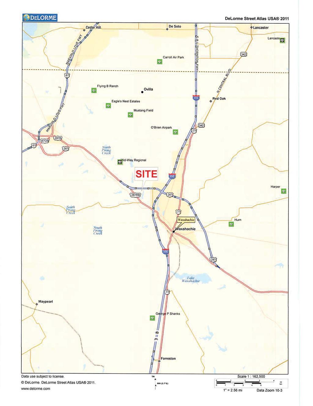
1 PRIME HIGHAY LOCATION Multi - Family Land Acres axahachie, Texas LOCATION: SIZE: The subject property is located on the south side of U.S. Highway 287 Bypass, approximately 1.5 miles west of I-35E and the new $185 million dollar Baylor Scott & hite Medical Complex in axahachie Acres; 284,229 S.F. ZONED: Planned Development - Multi-Family -2 UTILITIES: FRONTAGE: DEPTH: All utilities are available. U.S. Hwy. 287 Bypass ft ft ft. PRICE: $3.25 Per S.F.; $923, COMMENTS: Great visibility from U.S. Highway 287 Bypass. Minutes from shopping, schools, churches, and the entire DF metroplex. In May of 2015, the axahachie ISD purchased the adjoining 309 acres for a future High School (opening in 2018) and Jr. High. For More Information Call Joe Rust Company Ac-MF-ax-FS-2017.docx Information furnished is from sources deemed to be reliable but is not guaranteed by Joe Rust Company and is subject to change in price, correction, errors and omissions, prior sales and withdrawal without notice.
2

3 6.536 Acres - MF Zoning April 17, 2017 Parcels <all other values> Disclaimer: This product is for informational purposes only and has not been prepared for or be suitable for legal, engineering, or surveying purposes. It does not represent an on-the-ground survey and represents only the approximat e relative location of boundaries U.S. Highway State Hwy 1:25, mi km Interstate Major Road Ellis Appraisal District & BIS Consulting - This product and relative contents are the property of the respective governmental entity and BIS Consultants. Use is restricted for official purposes.
4 FU GT LS TR A NORTH N0 44'41" ' S0 43'12"E 80.66' TRACT 3 O P R E C T NOTES ADDRESSING SCHEDULE B ECEPTIONS: U.S. HIGHAY 287 BYPASS TRACT 1 ( ACRES) (Pursuant to Commitment for Title Insurance, provided by Chicago Title Insurance Company, GF. No , effective date June 17, 2016, issued, 7/1/2016 at 8:00-AM.) ASPHALT PAVEMENT ASPHALT PAVEMENT ASPHALT PAVEMENT b. Due to the vague description of the Ellis Prairie Soil Conservation District Easement recorded in Volume 465, Page 482, and Volume 474, Page 33, Real Property Records, Ellis County, Texas the surveyor is unable to determine its exact location. c. The Texas Power & Light Company Easement recorded in Volume 494, Page 44, Real Property Records, Ellis County, Texas does not affect the surveyed property. C "RPLS 3047" 0.1' EST OF AND 4.9' SOUTH OF N86 03'43"E 83.49' N88 53'55"E ' P.O.B. 1.7' NORTH OF (5/8" IRF (TRACTS 1 & 2) 2.2' NORTH OF N69 31'23"E 2.63') N88 53'55"E ' 3.8' NORTH OF 2.5' NORTH OF 20' UTILITY EASEMEN INST. NO ' ATER LINE EASEMENT CLERK'S FILE NO OHE OHE OHE OHEOHE OHE OHE OHE OHE OHE OHE OHE OHE OHE OHE OHE OHE OHE 15' T.P.&L. CO 15' UTILITY EASEMENT ELECTRIC EASEMENT 25' UTILITY EASEMENT 20' ATER LINE EASEMENT VOL. 799, PG. 220 VOL. 539, PG. 437 CLERK'S FILE NO VOL. 2206, PG ' UTILITY EASEMENT VOL. 799, PG. 220 VOL. 2206, PG. 923 d. The surveyed property is a portion of the property described in the document recorded in Volume 940, Page 197, Official Public Records of Ellis County, e. The surveyed property is a portion of the property described in the document recorded in Volume 940, Page 199, Official Public Records of Ellis County, f. The surveyed property is a portion of the property described in the document recorded in Volume 715, Page 780, Official Public Records of Ellis County, g. The Texas Power & Light Company Easement recorded in Volume 799, Page 220, Real property Records of Ellis County, Texas does affect the surveyed property k. The Utility Easement recorded in Volume 2206, Page 943, Real Property Records, Ellis County, Texas does affect the surveyed property and is shown hereon. TRACT 1 CALLED ACRES AAHACHIE INDEPENDENT SCHOOL DISTRICT INST. NO l. The ater Line Easement Agreement recorded in Clerk's File No , Real Property Records, Ellis County, Texas does affect the surveyed property TRACT 2 (6.525 ACRES) (Pursuant to Commitment for Title Insurance, provided by Chicago Title Insurance Company, GF. No , effective date June 21, 2016, issued, 7/5/2016 at 8:00-AM.) b. The Utility Easement recorded in Volume 2206, Page 923, Real Property Records, Ellis County, Texas does affect the surveyed property and is shown hereon. c. The Texas Power & Light Company Easement recorded in Volume 539, Page 437, Deed Records, Ellis County, Texas does affect the surveyed property d. The Texas Power & Light Company Easement recorded in Volume 799, Page 220, Deed Records, Ellis County, Texas does affect the surveyed property NORTH e. The Utility Easement recorded in Volume 2154, Page 2119, Real Property Records, Ellis County, Texas does affect the surveyed property and is shown hereon. f. The surveyed property is a portion of the property described in the document recorded in Volume 940, Page 197, Official Public Records of Ellis County, GRAPHIC SCALE IN FEET g. The surveyed property is a portion of the property described in the document recorded in Volume 940, Page 199, Official Public Records of Ellis County, 1" = 2436 TRACT ACRES 284,243 SQ. FT. S0 47'05"E ' N0 47'05" ' TRACT ACRES 453,431 SQ. FT. S0 43'12"E ' CALLED ACRES B & T REALTY SERVICES, INC. VOL. 2198, PG h. The surveyed property is a portion of the property described in the document recorded in Volume 715, Page 780, Official Public Records of Ellis County, l. The ater Line Easement Agreement recorded in Clerk's File No , Real Property Records, Ellis County, Texas does affect the surveyed property VICINITY MAP N.T.S. REMAINDER OF CALLED ACRES THE CROLEY FAMILY FOUNDATION VOL. 2479, PG. 673 REMAINDER OF CALLED ACRES JOE RUST VOL. 1746, PG LEGAL DESCRIPTION TRACT ACRES BEING a tract of land situated in the illiam C. Tunnell Survey, Abstract No. 1080, City of axahachie, Ellis County, Texas; and being part of a called acre tract of land described in Special arranty Deed to Joe Rust recorded in Volume 1746, Page 2455 of the Official Public Records, Ellis County, Texas; and being more particularly described as follows: BEGINNING at a 1/2-inch iron rod found for the northernmost northeast corner of a called acre tract of land described in Special arranty Deed to The Cowley Family Foundation recorded in Volume 2479, Page 673 of said Official Public Records and being in the south right-of-way line of U.S. Highway 287 (a variable width right-of-way); THENCE with said south right-of-way line of U.S. Highway 287, North 88 53'55" East, a distance of feet to a 1/2-inch iron rod found for the northwest corner of a called acre tract of land described in Special arranty Deed to B & T Realty Services, Inc. recorded in Volume 2198, Page 1442 of said Official Public Records; THENCE departing said south right-of-way line of U.S. Highway 287 and with the west line of said acre tract, South 0 43'12" East, a distance of feet to a 1/2-inch iron rod found for the easternmost northeast corner of said acre tract; LEGEND BO OR PEDESTAL HANDHOLE MANHOLE MARKER SIGN METER MARKER PINFLAG POLE STORAGE TANK VALVE (ECEPT ATER) VAULT ELL TV CABLE TV ROOF DRAIN ELEVATION BENCHMARK FLO DIRECTION MONITORING ELL T I N FUEL TANK FLOOD LIGHT GUY ANCHOR GUY ANCHOR POLE UTILITY POLE ELECTRIC SITCH ELECTRIC TRANSFORMER HANDICAPPED PARKING PARKING METER RAILROAD SIGNAL RAILROAD SIGN SIGN MARQUEE/BILLBOARD A/C UNIT BASKET BALL GOAL BORE LOCATION FLAG POLE GOAL POST GREASE TRAP IRRIGATION VALVE LIGHT STANDARD MAIL BO NES STAND PHONE BOOTH IRSC IRFC PKS PKF IRF S F P.O.B. ASPHALT PAVEMENT Copyright 2016 Kimley-Horn and Associates, Inc. All rights reserved C E F G P R S D T TR U S LINE TYPE LEGEND SS GAS OHE UGE UGT COMMUNICATIONS ELECTRIC OR POER FIBER OPTIC NATURAL GAS PETROLEUM OR PIPELINE RAILROAD SAN. SEER OR ASTEATER STORM SEER TELEPHONE TRAFFIC UNIDENTIFIED ATER SECURITY CAMERA SANITARY SEER BO SANITARY SEER CLEAN OUT SANITARY SEER LIFT STATION STORM SEER DRAIN TRAFFIC BARRIER TRAFFIC BOLLARD TRAFFIC CAMERA TRAFFIC SENSOR TRAFFIC SIGNAL TRASH BIN TREE ATER BO FIRE SPRINKLER CONNECTION FIRE HYDRANT ATER VALVE AIR RELEASE VALVE ATER ELL 5/8" IRON ROD / "KHA" CAP SET IRON ROD ITH CAP FOUND PK NAIL SET PK NAIL FOUND IRON ROD FOUND "" CUT IN CONCRETE SET "" CUT IN CONCRETE FOUND POINT OF BEGINNING P.O.C. POINT OF COMMENCING BOUNDARY LINE EASEMENT LINE BUILDING LINE ATER LINE SANITARY SEER LINE STORM SEER LINE UNDERGROUND GAS LINE OVERHEAD UTILITY LINE UNDERGROUND ELECTRIC LINE UNDERGROUND TELEPHONE LINE FENCE CONCRETE PAVEMENT C "RPLS 3047" NOTES: There are no buildings existing on the surveyed property. FLOOD STATEMENT: According to Community Panel No C0175F, dated June 3, 2013 of the National Flood Insurance Program Map, Flood Insurance Rate Map of Ellis County, Texas, Federal Emergency Management Agency, Federal Insurance Administration, this property is not within a special flood hazard area. If this site is not within an identified special flood hazard area, this flood statement does not imply that the property and/or the structures thereon will be free from flooding or flood damage. On rare occasions, greater floods can and will occur and flood heights may be increased by man-made or natural causes. This flood statement shall not create liability on the part of the surveyor. S89 10'45" ' S88 56'10" ' N88 56'10"E ' 20' UTILITY EASEMENT VOL. 2154, PG SURVEYORS CERTIFICATION: To: Garrett Moore Company - Oklahoma, LLC; Rattikin Title Company; and Chicago Title Insurance Company: I hereby certify that this survey substantially complies with the current Texas Society of Professional Land Surveyors Standards and Specifications for a Category 1A Condition II Survey. Survey Date: July 1, 2016 J. Andy Dobbs Registered Professional Land Surveyor No Kimley-Horn and Associates, Inc Merit Drive Suite 1000 Dallas, Texas Ph andy.dobbs@kimley-horn.com PRELIMINARY THIS DOCUMENT SHALL NOT BE RECORDED FOR ANY PURPOSE AND SHALL NOT BE USED OR VIEED OR RELIED UPON AS A FINAL SURVEY DOCUMENT S0 43'12"E 23.47' BARBED IRE FENCE ( N80 51'45" 0.95') CALLED ACRES SHEPHERD PLACE HOMES, INC. VOL. 1906, PG /5/16 UPDATED SURVEY ITH NE SCHEDULE B ITEMS. No. DATE REVISION DESCRIPTION THENCE departing said west line of the acre tract and with a north line of said acre tract, South 88 56'10" est, a distance of feet to a 1/2" iron rod found for an inner ell corner of said acre tract; THENCE with an east line of said acre tract, North 0 47'05" est, a distance of feet to the POINT OF BEGINNING and containing acres or 453,431 square feet of land. Bearing system based on the Texas Coordinate System of 1983, North Central Zone (4202), North American Datum of LEGAL DESCRIPTION TRACT ACRES BEING a tract of land situated in the illiam C. Tunnell Survey, Abstract No. 1080, City of axahachie, Ellis County, Texas; and being part of a called acre tract of land described in Special arranty Deed to The Cowley Family Foundation recorded in Volume 2479, Page 673 of the Official Public Records, Ellis County, Texas; and being more particularly described as follows: BEGINNING at a 1/2-inch iron rod found for the northernmost northeast corner of said acre tract and being in the south right-of-way line of U.S. Highway 287 (a variable width right-of-way); THENCE departing said south right-of-way line of U.S. Highway 287 and with an east line of said acre tract, South 0 47'05" East, a distance of feet to a 1/2" iron rod found for an inner ell corner of said acre tract; THENCE North 88 56'10" East, a distance of feet to a 1/2-inch iron rod found for the easternmost northeast corner of said acre tract and being in the west line of a called acre tract of land described in Special arranty Deed to B & T Realty Services, Inc. recorded in Volume 2198, Page 1442 of said Official Public Records; THENCE with said west line of said acre tract, South 0 43'12" East, a distance of feet to the easternmost northeast corner of a called acre tract of land described in Special arranty Deed to axahachie Independent School District recorded in Instrument No of said Official Public Records; from said point a 1/2-inch iron rod found for reference bears North 80 51'45" est, a distance of 0.95 feet and a 1/2-inch iron rod found for the southwest corner of said acre tract bears South 0 43'12" East, a distance of feet; THENCE departing said west line of a acre tract and with a north line of said acre tract, South 89 10'45" est, a distance of feet to a 1/2" iron rod with RPLS 3047 cap found for an inner ell corner of said acre tract; THENCE with an east line of said acre tract, North 0 44'41" est, a distance of feet to a 1/2-inch iron rod with "RPLS 3047" cap found for the northernmost northeast corner of said acre tract and in said south right-of-way line of U.S. Highway 287; THENCE with said south right-of-way line of U.S. Highway 287 and the north line of said acre tract, the following courses and distances: North 86 03'43" East, a distance of feet to a point for corner; from said point a 5/8-inch iron rod found for reference bears North 69 31'23" East, a distance of 2.63 feet; North 88 53'55" East, a distance of feet to the POINT OF BEGINNING and containing acres or 284,243 square feet of land. Bearing system based on the Texas Coordinate System of 1983, North Central Zone (4202), North American Datum of TSPS LAND TITLE SURVEY ILLIAM C. TUNNELL SURVEY ABSTRACT NO CITY OF AAHACHIE, ELLIS COUNTY, TEAS Merit Drive, Suite 1000 Tel. No. (972) Dallas, Texas FIRM # Fax No. (972) Scale 1" = 50' Drawn by JAD/JBH Checked by Date Project No. Sheet No. DAB JUNE OF 1 DG NAME: K:\DAL_SURVEY\ BUFFALO RUN AAHACHIE\DG\ BUFFALO RUN AAHACHIE_TSPS.DG PLOTTED BYHOPPER, BRADIN 7/5/2016 3:45 PM LAST SAVED 7/5/2016 3:45 PM

5
6
Synergy Park Addition (Companion to item 3)
") Synergy Park Addition (Companion to item 3) Attachments: 1. Locator 2. Replat staff report 3. Replat W P G r es rg eo e s Bu hh wy Lot 6A 4.02-acres Lot 4C 13.02-acres Fran k Lots 4C and 6A, Block A Synergy
Synergy Park Addition (Companion to item 3) Attachments: 1. Locator 2. Replat staff report 3. Replat W P G r es rg eo e s Bu hh wy Lot 6A 4.02-acres Lot 4C 13.02-acres Fran k Lots 4C and 6A, Block A Synergy
2213 BUTLER PAD SITE NEAR NEW PARKLAND HOSPITAL. Butler Street at Redfield Dallas, Texas EDGE REALTY PARTNERS
 PAD SITE NEAR NEW PARKLAND HOSPITAL 2213 BUTLER Butler Street at Redfield Dallas, Texas EDGE REALTY PARTNERS 2213 BUTLER // Dallas, Texas LOCATION 2213 Butler Street Dallas, Texas 75235 SIZE 83,370 square
Honorable Mayor Bill Agan and members of the Richland Hills City Council. Final Plat Richland Hills, Lots 1 & 2, Block 1 Brumlow Addition
 2B - 1 Memorandum To: From: Date: Subject: Honorable Mayor Bill Agan and members of the Richland Hills City Council Jason Moore, Assistant City Manager January 17, 2017 Final Plat Richland Hills, Lots
COUNTY OF ADAMS, STATE OF COLORADO E. 40TH AVE. TOWER RD. E. 38TH AVE. SALIDA ST. HIGH LINE CANAL PROJECT LOCATION E. 32ND PKWY.
 LEGAL DESCRIPTION:, GATEWAY EAST AT TOWER SUBDIVISION FILING NO. 1, SAID PARCEL CONTAIN 598,154 SQUARE FEET OR MORE OR LESS GENERAL NOTES: 1. NOTICE: ACCORDING TO COLORADO LAW YOU MUST COMMENCE ANY LEGAL
PLAT OF SURVEY VICINITY MAP (NOT TO SCALE) N N W E SITE BENCHMARK # 2 W E N&D ON BACK OF CURB NAVD 88 S S 0' 10' 20' 40' 60' 1" = 20' TOP=106.7
 N N W E SITE BENCHMARK # 2 W E N&D ON BACK OF CURB NAVD 88 S S 0' 10' 20' 40' 60' 1 = 20' TOP=106.7") PLAT OF SURVEY VICINITY MAP (NOT TO SCALE) N N W E SITE BENCHMARK # 2 W E N&D ON BACK OF CURB 106.21 NAVD 88 S S 0' 10' 20' 40' 60' 1" = 20' TOP=106.72 N INV PVC=99.27 S INV PVC=99.32 E INV CLAY=99.39
PLAT OF SURVEY VICINITY MAP (NOT TO SCALE) N N W E SITE BENCHMARK # 2 W E N&D ON BACK OF CURB 106.21 NAVD 88 S S 0' 10' 20' 40' 60' 1" = 20' TOP=106.72 N INV PVC=99.27 S INV PVC=99.32 E INV CLAY=99.39
2800 OAK LAWN AVENUE ± 25,000 SF ON OAK LAWN AVE AVAILABLE FOR LEASE. SEC Oak Lawn Ave & Congress Ave Dallas, Texas EDGE REALTY PARTNERS
 ± 25,000 SF ON OAK LAWN AVE AVAILABLE FOR LEASE 2800 OAK LAWN AVENUE SEC Oak Lawn Ave & Congress Ave Dallas, Texas EDGE REALTY PARTNERS LOCATION 2800 Oak Lawn Avenue Dallas, Texas 75219 SIZE ± 25,000 square
Memorandum September 13, 2018
 Memorandum September 13, 2018 TO: FROM: Planning and Zoning Commission Julie Couch, Town Manager Israel Roberts, AICP Planning Manager SUBJECT: FINAL PLAT FOR THE EBERSOHL ADDITION BACKGROUND: This is
ORDINANCE NO
 ORDINANCE NO. 3 0 3 5 7 170302 An ordinance providing for the abandonment of portions of two alleys and portions of Texas, Live Oak, and Cantegral Streets, located adjacent to City Block 289 in the City
CERTIFIED SURVEY MAP
 SCONSIN STATE PLANE N:389676.12 E:2130390.15 Center of Section 23 CERTIFIED SURVEY MAP 734.06' THE (PRITCHETTE) ORIGINAL PLAT OF ALL IN THE NW 1 4 OF THE SE 1 4 OF FRACTIONAL SECTION 23, T7N, R9E, IN THE
FOR SALE ACRES UNDEVELOPED COMMERCIAL LAND DURHAM LAKES, CITY OF FAIRBURN, FULTON COUNTY, GA
 FOR SALE - 7.23 ACRES UNDEVELOPED COMMERCIAL LAND DURHAM LAKES, CITY OF FAIRBURN, FULTON COUNTY, GA COMMENTS This bank owned opportunity 7.23 acres of undeveloped commercial land located within the city
SUBDIVISION APPLICATION
 SUBDIVISION APPLICATION Preliminary Plat Minor Plat Final Plat Amended Plat Applicant Name: Owner (if different from applicant) Name: Company: Company: Address: Address: City, State, Zip City, State, Zip
ORDINANCE NO
 ORDINANCE NO. 3 0 3 1 1 170133 An ordinance providing for the abandonment and relinquishment of portion of a sanitary sewer easement, located in City Block 245 in the City of Dallas and County of Dallas,
Palm Ave Hialeah Building Data Palm Avenue
 400-450 Palm Ave Hialeah Building Data Address 400-450 Palm Avenue City, State Hialeah, Florida County Miami Dade parcel # 04-3118-001-1950 and 1960 Zoning Retail Commercial - BU2 Land Size 13500 Type
RIVERDALE CITY PLANNING COMMISSION APPLICATION FOR RESIDENTIAL SUBDIVISION SITE PLAN APPROVAL
 Community Development 4600 So. Weber River Drive Riverdale, Utah 84405 RIVERDALE CITY PLANNING COMMISSION APPLICATION FOR RESIDENTIAL SUBDIVISION SITE PLAN APPROVAL CASE NO: DATE SUBMITTED: APPLICANT S
ARTICLE 900 PLAT AND PLAN REQUIREMENTS
 ARTICLE 900 PLAT AND PLAN REQUIREMENTS SEC. 900.1 ITEMS TO BE SHOWN ON PLAT OR PLAN General (1) Property lines of all property owners adjacent to the exterior boundaries of the project shall be located
PLANNING & ZONING COMMISSION Town of Little Elm
 PLANNING & ZONING COMMISSION Town of Little Elm Work Session and Regular Meeting Thursday, June 15, 2017 Town Hall - Council Chamber & Conference Room To address the Commission for any public hearing item
SECTION SITE SURVEYS
 PART 1 - GENERAL 1.1 DESCRIPTION SECTION 02 21 00 SPEC WRITER NOTES: 1. Use this section only for NCA projects. 2. Delete between //---// if not applicable to project. Also delete any other item or paragraph
DIVISION 2 - CONSTRUCTION PLAN AND MISCELLANEOUS REQUIREMENTS
 DIVISION 2 - CONSTRUCTION PLAN AND MISCELLANEOUS REQUIREMENTS 2.1 Required Plan Sheets 2.2 Drawing Requirements 2.3 Graphic Standards 2.4 Easements 2.5 Utility Locations 2.6 Private Facility Locations
NOT TO BE SUBMITTED WITH SKETCH DESIGN APPROVAL Subdivision Checklist: Major Subdivision Final Plat
 Must be received with review fee (equal to $200.00, plus $25.00 per lot) no later than 15 days prior to Planning Board meeting, which is normally the first Monday of the month (certain holidays may modify
PRELMINARY PLAT CHECKLIST
 PRELMINARY PLAT CHECKLIST A. All preliminary plat submitted for approval shall be prepared by a Registered Professional Land Surveyor. B. Preliminary plats must be drawn to a scale of XXX with such accuracy
A.3. ARTICLE 7 PLAN REQUIREMENTS FOR MINOR SUBDIVISION AND/OR LAND DEVELOPMENT
 700. 701.A.3. ARTICLE 7 PLAN REQUIREMENTS FOR MINOR SUBDIVISION AND/OR LAND DEVELOPMENT SECTION 700 PURPOSE The purpose of this Article is to set forth a streamlined set of Plan Requirements for minor
Windridge Market. Build-to-Suit or Ground Lease. Location: Available Space: Highlights: Jamie Knight x1
 Location: NWC of W San Antonio St & Mockingbird Ln 1601 W. San Antonio St, Lockhart, Texas 78644 Highlights: Signalized Intersection Zoned CMB (Commercial Medium Business) which allows for fuel sales,
MINOR SUBDIVISION PLAT CHECKLIST
 MINOR SUBDIVISION PLAT CHECKLIST Project Name: Tax ID #: Project Number: Date: _ Reviewed By: Telephone: NOTES: All lots on septic systems must comply with the Fulton County Health Department requirements
Subdivision of existing two lots into three lots.
 PP-15-00189 Item No. 4-1 PC Staff Report 06/22/2015 PLANNING COMMISSION REPORT NON PUBLIC HEARING ITEM PUBLIC HEARING ON THE VARIANCE ONLY ITEM NO 4: PRELIMINARY PLAT FOR DEERFIELD WOODS SUBDIVISION NO.
MINOR PLAT. The following documents are provided as required by the City of Conroe for use in the above titled platting submittals:
 Public Works - Engineering Division CITY OF CONROE MINOR PLAT The following documents are provided as required by the City of Conroe for use in the above titled platting submittals: Submittal Questionnaire
PARCEL MAP CHECK ENG
 Engineering Division 201 North Broadway, Escondido, CA 92025 (760) 839-4651, FAX (760) 839-4597 PARCEL MAP CHECK ENG To: Date: Project: Site Address Check No. Attn: Via: The attached plans have been reviewed
ACRE PROPERTY FOR COMMERCIAL DEVELOPMENT
 DE ZAVALA ROAD SAN ANTONIO, TEXAS 0.8972 ACRE PROPERTY FOR COMMERCIAL DEVELOPMENT All information furnished regarding this property is from sources deemed reliable; however, Harry G. Leeper, Jr., Broker,
Location Map. Subject Site. Project Name: Boulder Lakes 4th Addn. Request: Preliminary Subdivision Case No.: 01-PS INVER GROVE HEIGHTS
 HOLIDAY LN LOUIS LANE INVER GROVE HEIGHTS AMES CROSSING RD STATE TRUNK HWY. NO. 55 CHAPEL LANE O'NEILL DR VIKINGS PARKWAY LONE OAK DRIVE C.S.A.H. NO. 26 (LONE OAK RD.) COURTHOUSE LN TRUNK HWY. NO. 55 JOYCE
CITY OF FAYETTEVILLE, ARKANSAS FINAL PLAT FOR STAFF USE ONLY FINAL PLAT FEE: $ $ Date Application Submitted: Date Accepted as Complete:
 CITY OF FAYETTEVILLE, ARKANSAS FINAL PLAT FOR STAFF USE ONLY FINAL PLAT FEE: $200.00-$800.00 Date Application Submitted: Date Accepted as Complete: Project Number: Public Hearing S-T-R: PP#: Zone: Please
ARTICLE 900 PLAT AND PLAN REQUIREMENTS
 Final SEC. 900.01 ARTICLE 900 PLAT AND PLAN REQUIREMENTS General provisions. (a) Scale. The scale of all plats and plans shall be a minimum of 1 to 100 ft. (b) Size. The minimum page size for all plats
PUBLIC HEARING* N/A. C I T Y O F T A C O M A Planning & Development Services Department 747 Market St, Rm 345 Tacoma, WA 98402
 C I T Y O F T A C O M A Planning & Development Services Department 747 Market St, Rm 345 Tacoma, WA 98402 PUBLIC HEARING* Date of Notifcation: 10/5/2018 Application Received: 04/19/2018 Application Complete:
For the purposes of this resolution, the following definitions of terms
 COUNCIL CHAMBER February 23, 2011 A RESOLUTION DETERMINING UPON THE NECESSITY OF ACQUIRING REAL PROPERTY AND AUTHORIZING ITS APPROPRIATION ANDIOR CONDEMNATION FOR A MUNICIPAL PURPOSE AND PUBLIC USE. DEFINITIONS:
AIR ONE. 829 HULL ROAD Ormond Beach, Florida BENCHMARK #1 EL NAIL IN POWER POLE EASTERLY RIGHT-OF-WAY LINE TOMOKA AIRPORT ROAD (UR) HULL ROAD
 HULL ROAD") NORTH LINE LOT 2 SOUTH LINE LOT 1 S75 46'55"E 2 NORTH LINE LOT 3 SOUTH LINE LOT 2 N75 43'32"W(UR) S75 43'32"E(D) N75 43'32"W(URD) NORTH LINE LOT 1 SOUTH LINE LOT 12 225.15'(M)225'(UR) P.O.R. PARCELS II
NORTH LINE LOT 2 SOUTH LINE LOT 1 S75 46'55"E 2 NORTH LINE LOT 3 SOUTH LINE LOT 2 N75 43'32"W(UR) S75 43'32"E(D) N75 43'32"W(URD) NORTH LINE LOT 1 SOUTH LINE LOT 12 225.15'(M)225'(UR) P.O.R. PARCELS II
A portion of the land (surplus land), described in Exhibit A, is no longer needed for a state highway purpose.
, described in Exhibit A, is no longer needed for a state highway purpose.") TEXAS TRANSPORTATION COMMISSION DENTON County MINUTE ORDER Page 1 of 2 DALLAS District In the city of Northlake, DENTON COUNTY, on INTERSTATE 35W, the State of Texas (state) acquired certain land for a
TEXAS TRANSPORTATION COMMISSION DENTON County MINUTE ORDER Page 1 of 2 DALLAS District In the city of Northlake, DENTON COUNTY, on INTERSTATE 35W, the State of Texas (state) acquired certain land for a
ALTA/NSPS LAND TITLE SURVEY
 ALTA/NSPS LAND TITLE SURVEY VICINITY MAP COMMITMENT FILE NO. 142792 PEAVEY ROAD COLUMBIA CT W COLUMBIA CT N Most northerly corner of Tract K, RLS No. 48 OWNER: CITY OF CHASKA, MINNEOSTA FND OPEN IP RLS
LAND FOR SALE - ± ACRES
 LAND FOR SALE - ± 6.109 ACRES 14248 FM 2769 Leander, TX 78641 3 2 5 6 183 SITE LOOP 1 620 620 1 LOCATION: SIZE: FRONTAGE/ ACCESS: UTILITIES: ZONING: TOPOGRAPHY: Approximately 4.7 miles west of FM 620 and
Towne Center Boulevard William Penn Highway. Lot 2. 1 Mile Population: 3,600 Median HH Income: $36,800
 Walmart Outparcel For Sale Huntingdon, PA Store #5470 6716 Towne Center Blvd Towne Center Boulevard William Penn Highway Lot 2 Raystown Road For more information about this site, contact: Lot 2: ±1.72
1. Action taken on the Planning & Zoning Commission items by City Council at the February 27, 2018, regular meeting.
 AGENDA CITY OF ALLEN PLANNING AND ZONING COMMISSION REGULAR MEETING TUESDAY, MARCH 6, 2018 7:00 P.M. CITY COUNCIL CHAMBERS ALLEN CITY HALL 305 CENTURY PARKWAY ALLEN, TEXAS 75013 Call to Order and Announce
Two Buildings and Acres
 18530 State Highway 123, Seguin, Texas 78155 LOCATION Located on the corner of Highway 123 and Elm Creek Road (CR 411) between Seguin and Stockdale, Texas LAND 1.886 Acres with approximately 485 feet of
ORDINANCE NO. BE IT ORDAINED BY THE CITY COUNCIL OF THE CITY OF DALLAS:
 ORDINANCE NO. * -1% L I An ordinance providing for the abandonment and relinquishment of a portion of a sanitary sewer easement located in City Block 1/818 in the City of Dallas and County of Dallas, Texas;
Preliminary Subdivision Application (Major) (Four (4) lots or more)
 (Four (4) lots or more)") Gunnison City Offices www.gunnisoncity.org 38 West Center Gunnison, Utah 84634 (435) 528 7969 Date of Application: Preliminary Subdivision Application (Major) (Four (4) lots or more) APPLICANT INFORMATION
Gunnison City Offices www.gunnisoncity.org 38 West Center Gunnison, Utah 84634 (435) 528 7969 Date of Application: Preliminary Subdivision Application (Major) (Four (4) lots or more) APPLICANT INFORMATION
CONSTRUCTION PLANS for HALCYON A RESIDENTIAL SUBDIVISION 6100 MIDNIGHT PASS ROAD, SARASOTA, FL 34242
 CONSTRUCTION PLANS for HALCYON A RESIDENTIAL SUBDIVISION 6100 MIDNIGHT PASS ROAD, SARASOTA, FL 34242 SECTION 18, TOWNSHIP 37 SOUTH, RANGE 18 EAST SARASOTA COUNTY, FLORIDA PID: 0030001 A DEVELOPMENT BY
-MENDOCINO COUNTY PLANNING AND BUILDING SERVICES- DIVISION OF LAND REGULATIONS TITLE 17
 ARTICLE VI -- GENERAL REGULATIONS AND PROVISIONS Sec. 17-50. Sec. 17-51 General Plan. Sec. 17-52 Lot and Block Design and Configuration. Sec. 17-53 Lot Access. Sec. 17-54 Private Roads. Sec. 17-55 Water
DEVELOPMENT POLICY INFRASTRUCTURE GUIDELINES FOR NEW DEVELOPMENT
 CITY OF HAYS SUBJECT DEVELOPMENT POLICY INFRASTRUCTURE GUIDELINES FOR NEW DEVELOPMENT ISSUED BY LAST REVISION DATE POLICY MANUAL REVISION DATE City Commission 3-13-08 10-22-09 POLICY STATEMENT: The City
1 Mile: Popula on: 9,400 Median HH Income: $65, Mile: Popula on: 113,000 Median HH Income: $59,600
 Walmart Outparcels For Sale Dallas, TX Store #2105 Midway Road and US I-635 US I 635 Lot 5 Lot 6 Lot 7 Midway Raod Lot 8 For more informa on about this site, contact: Ryan Tinch Hollis Bloom (214) 265-1555
ORDINANCE NO. An ordinance ratifying and adopting an agreement between the cities of Dallas and Rowlett
 150504 03-12-15 ORDINANCE NO. 29673 An ordinance ratifying and adopting an agreement between the cities of Dallas and Rowlett adjusting their common boundary line; releasing a certain area of land to the
Preliminary Subdivision Application (Minor) (Three (3) lots or less)
 (Three (3) lots or less)") Gunnison City Offices www.gunnisoncity.org 38 West Center Gunnison, Utah 84634 (435) 528 7969 Date of Application: Preliminary Subdivision Application (Minor) (Three (3) lots or less) APPLICANT INFORMATION
Gunnison City Offices www.gunnisoncity.org 38 West Center Gunnison, Utah 84634 (435) 528 7969 Date of Application: Preliminary Subdivision Application (Minor) (Three (3) lots or less) APPLICANT INFORMATION
Avg. HH Income th Avenue Fort Worth, TX
 Site Available Southwest Corner of Old Decatur Road & W.J. Boaz Road PROPERTY SPECIFICATIONS: LOCATION: LAND SIZE: Southwest corner of Old Decatur Road & W.J. Boaz Road Approximately 1.46 Acres SITE ZONED:
PRELIMINARY PLAT CHECK LIST
 PRELIMINARY PLAT CHECK LIST Name of Proposed Subdivision: The following items must be included with the initial submittal of a Preliminary Plat: Application, filled out completely Project Narrative Pre-application
QUITCLAIM DEED CR 202 THE STATE OF TEXAS KNOW ALL MEN BY THESE PRESENTS: COUNTY OF WILLIAMSON
 QUITCLAIM DEED CR 202 THE STATE OF TEXAS KNOW ALL MEN BY THESE PRESENTS: COUNTY OF WILLIAMSON That WILLIAMSON COUNTY, TEXAS, hereinafter referred to as Grantor, whether one or more, for and in consideration
$5,462 ($3,762, plus closing costs not to exceed
 4: Q i Jtwié9,21O A RESOLUTION DETERMINING UPON THE NECESSITY OF ACQUIRING REAL PROPERTY AND AUTHORIZING ITS APPROPRIATION AND/OR CONDEMNATION FOR A MUNICIPAL PURPOSE AND PUBLIC USE. DEFINITIONS: shall
ABBREVIATION LEGEND SITE INFORMATION:
 SITE INFORMATION: Current Zone: R-3 PUD, governed by Fox Hollow 2nd MDA Basis of Elevations: Northeast Corner of Section 13, T6S, R1W, S.L.B. & M Elevation: 4599.26 (Benchmark) ABBREVIATION LEGEND Owners:
Februarv27, WHEREAS, the City of Dallas owns tracts of land which are used for Lake Ray. Hubbard; and
 WHEREAS, the City of Dallas owns tracts of land which are used for Lake Ray WHEREAS, the City of Rowlett has requested a wastewater easement with a temporary Hubbard; and Februarv27, 213 By: Assistant
APPENDIX B. SUBMISSION REQUIREMENTS
 Master Major Site Minor Site Landscape Section B.1 Table of /Plat Requirements Proposed or approved name of development, project, subdivision, and/or phase. Location, including township, county, and state.
ORDINANCE N0.18-ll6. WHEREAS, City has prepared a Service Plan for said tract which is attached as Exhibit "A" to this ordinance; &
 c: 0 ORDINANCE N0.18-ll6 AN ORDINANCE ANNEXING THE HEREINAFTER DESCRIBED TERRITORY TO THE CITY OF FORT STOCKTON, PECOS COUNTY, TEXAS, AND EXTENDING THE BOUNDARY LIMITS OF SAID CITY SO AS TO INCLUDE SAID
DOLLAR GENERAL 15 YEAR ABSOLUTE NNN LEASE
 OFFERED FOR SALE DOLLAR GENERAL 15 YEAR ABSOLUTE NNN LEASE NORTHEAST OF DALLAS/FORT WORTH 1668 CR 32200 Sumner (Paris) Texas 75486 LISTED BY: Gavin M Kam Brad F Kam 1.800.727.3147 Net Realty Advisors Galleria
STANDARDIZED LEGAL DESCRIPTIONS AND EXHIBITS
 STANDARDIZED LEGAL DESCRIPTIONS AND EXHIBITS Public Works Department, Engineering Division June 14, 2004 UNIFIED GOVERNMENT STANDARDIZED LEGAL DESCRIPTIONS AND EXHIBITS For: Roads, Bridges, Short Span
PLANNING COMMISSION STAFF REPORT
 PLANNING COMMISSION STAFF REPORT Alder-Robinson Subdivision Amending the Amended Plat of the Arcadia Heights Plat A Subdivision Case #PLNSUB2010-00044 2857 East 2100 South June 23, 2010 Applicant: Greg
152-A 198 ACRE POTENTIAL COMMERCIAL/INDUSTRAIL PARK
 152-A 198 ACRE POTENTIAL COMMERCIAL/INDUSTRAIL PARK PROPOSED CITY LIMITS PARKWAY AIRPORT 198 ACRES RAIL SIDING Proposed exit from Hwy. 60 for the Central Polk Parkway 3,923 Ft. Frontage 4 Lane Hwy. 60
ORDINANCE NO An ordinance providing for the abandonment and relinquishment of a portion of a utility
 easement, located in City Block KJ5453 in the City of Dallas and County of Dallas, An ordinance providing for the abandonment and relinquishment of a portion of a utility ORDINANCE NO. 2775 8 CH/3466 1
ORDINANCE NO. An ordinance providing for the abandonment and relinquishment of portions of three
 Dallas, Texas; providing for the quitclaim thereof to ATA Apartments Limited An ordinance providing for the abandonment and relinquishment of portions of three ORDINANCE NO. 2 90 7 7 storm sewer easements
The property is located south of Dell Diamond with 2, feet of rail frontage just south of US HWY 79.
 3 8 0 1 P a l m Va l l e y B l v d. R o u n d R o c k T e x a s 7 8 6 6 5 The property is located south of Dell Diamond with 2,865.09 feet of rail frontage just south of US HWY 79. 155.589 acres; There
An ordinance providing for the abandonment and relinquishment of a portion of a utility easement, located in
 160360 ORDINANCE NO. 30 0 2.3 An ordinance providing for abandonment and relinquishment of a portion of a utility easement, located in City Block 1/6360 in City of Dallas and County of Dallas, Texas; providing
FINAL MAP PLAN CHECK
 Engineering Division 201 North Broadway, Escondido, CA 92025 (760) 839-4651, FAX (760) 839-4597 FINAL MAP PLAN CHECK To: Date: Project: Address: Check No: Attn: VIA: The attached FINAL MAP has been reviewed
BOUNDARY DETAIL SCALE: 1" = 80'
 4. -1 7 (E) 10 PIPE LINE ESMT. BK. 7484, PG. 232 29 GV 42 R/ (E ) DE L 6 2 44 2 2 8.1 6" 0 2. SURVEYOR DOES NOT GUARANTEE THAT ALL UTILITIES ARE SHON OR THEIR LOCATIONS. IT IS THE RESPONSIBILITY OF THE
ARTICLE XVI SUBDIVISION DEVELOPMENT
 ARTICLE XVI SUBDIVISION DEVELOPMENT 16.0 The division of land into 4 or more lots that will require the construction or extension of public streets, water or sanitary sewerage (other than the direct connection
Dallas Sloan General Manager Barron Area Phone: (715) Toll Free: Fax: (715) NEW SERVICE PROCESS
 Toll Free: Fax: (715) NEW SERVICE PROCESS") Barron Area Phone: (715) 537-3171 Toll Free: 800-322-1008 Fax: (715) 637-1906 Dallas Sloan General Manager NEW SERVICE PROCESS Paperwork: Membership application social security number required for credit
Barron Area Phone: (715) 537-3171 Toll Free: 800-322-1008 Fax: (715) 637-1906 Dallas Sloan General Manager NEW SERVICE PROCESS Paperwork: Membership application social security number required for credit
ARTICLE 5 MINOR SUBDIVISION/LAND DEVELOPMENT
 ARTICLE 5 MINOR SUBDIVISION/LAND DEVELOPMENT SECTION 501 ONLY FINAL PLAN REQUIRED The classification of a proposed subdivision as a "Minor Subdivision" shall only require the submission, review and approval
PLANNED UNIT DEVELOPMENT & SUBDIVISION STAFF REPORT Date: November 17, 2016
 PLANNED UNIT DEVELOPMENT & SUBDIVISION STAFF REPORT Date: November 17, 2016 DEVELOPMENT NAME SUBDIVISION NAME LOCATION Autonation Ford of Mobile Autonation Ford of Mobile Subdivision 901, 909, and 925
Preliminary Plat & Layout Plan Submittal Guidelines
 Preliminary Plat & Layout Plan Submittal Guidelines PRELIMINARY PLAT & LAYOUT PLANS is typically the first step in the platting process. The purpose of the PRELIMINARY PLAT & LAYOUT PLANS is for the Applicant
SUBMITTAL REQUIREMENTS: The number indicates the number of copies for submittal (if applicable).
.") Office Use Only Preliminary Long Plat Long Subdivision Applicant Checklist PLANNING, COMMUNITY, & ECONOMIC DEVELOPMENT DEPARTMENT PRELIMINARY LONG PLAT LONG SUBDIVISION CHECKLIST Mailing Address: P.O.
Office Use Only Preliminary Long Plat Long Subdivision Applicant Checklist PLANNING, COMMUNITY, & ECONOMIC DEVELOPMENT DEPARTMENT PRELIMINARY LONG PLAT LONG SUBDIVISION CHECKLIST Mailing Address: P.O.
LOCATION MAP SHEET 1 OF 10
 OWNER: ADDRESS: LOCATION MAP CENTURY LAND HOLDINGS II, LLC 6500 RIVER PLACE BLVD. BUILDING 2, SUITE 200 AUSTIN, TX 78730 OWNER: CITY OF LEANDER ADDRESS: P.O. BOX 319 LEANDER, TX 78646 ACREAGE: LOTS ACREAGE:
BILL JOHNSON & ASSOCIATES REAL ESTATE COMPANY WILL CO-BROKER IF BUYER IS ACCOMPANIED BY HIS OR HER AGENT AT ALL PROPERTY SHOWINGS
 WITTE ROAD RANCH For more information: Bill Johnson & Associates Real Estate Company 420 East Main, Bellville, Texas 77418 979-865-5969 281-463-3791 979-992-2636 www.bjre.com This 36.7820 acres is conveniently
CHAPTER 32 SUBDIVISIONS SECTION TITLE PAGE NO.
 Page 1 of 46 CHAPTER 32 SUBDIVISIONS SECTION TITLE PAGE NO. SECTION 32-1 Purpose of Ordinance 3 SECTION 32-2 Definitions 3 SECTION 32-3 Staff Sketch Review 4 SECTION 32-4 Subdivision and PUD Plats Required
Auqust 27, For the purposes of this resolution, the following definitions of terms. shall apply: CITY : The City of Dallas
 COUNCIL CHAMBER Auqust 27, 2014 A RESOLUTION DETERMINING UPON THE NECESSITY OF ACQUIRING REAL PROPERTY AND AUTHORIZING ITS APPROPRIATION ANDOR CONDEMNATION FOR PUBLIC USE. DEFINITIONS: shall apply: For
géãç Éy VtÇtÇwt zât 5440 Routes 5 & 20 West Canandaigua, NY Phone: (585) / Fax: (585)
 / Fax: (585)") géãç Éy VtÇtÇwt zât 5440 Routes 5 & 20 West Canandaigua, NY 14424 Phone: (585) 394-1120 / Fax: (585) 394-9476 APPLICATION FOR LOT-LINE ADJUSTMENT The applicant is responsible for the completeness of all
géãç Éy VtÇtÇwt zât 5440 Routes 5 & 20 West Canandaigua, NY 14424 Phone: (585) 394-1120 / Fax: (585) 394-9476 APPLICATION FOR LOT-LINE ADJUSTMENT The applicant is responsible for the completeness of all
APPLICATION FOR PRELIMINARY PLAT CERRO GORDO COUNTY, IOWA
 APPLICATION FOR PRELIMINARY PLAT CERRO GORDO COUNTY, IOWA Before subdividing any tract of land and previous to the filing of an Application for conditional approval of the Preliminary Plat, the subdivider
PLANNING COMMISSION REPORT Regular Agenda Non-Public Hearing Item PRELIMINARY PLAT FOR JOHNSTON ADDITION; 706 E 23 RD ST (MKM)
") PP-16-00261 Item No. 2A- 1 PC Staff Report PP-16-00261 ITEM NO. 2A: PLANNING COMMISSION REPORT Regular Agenda Non-Public Hearing Item PRELIMINARY PLAT FOR JOHNSTON ADDITION; 706 E 23 RD ST (MKM) PP-16-00261:
PP-16-00261 Item No. 2A- 1 PC Staff Report PP-16-00261 ITEM NO. 2A: PLANNING COMMISSION REPORT Regular Agenda Non-Public Hearing Item PRELIMINARY PLAT FOR JOHNSTON ADDITION; 706 E 23 RD ST (MKM) PP-16-00261:
Application for Preliminary Plat Checklist
 Application for Preliminary Plat Checklist Note: No portion of an existing parcel may be sold or transferred to another party without first legally subdividing the property according to the City of Richmond
152 A 198 ACRE POTENTIAL COMMERCIAL/INDUSTRAIL PARK
 152 A 198 ACRE POTENTIAL COMMERCIAL/INDUSTRAIL PARK PROPOSED CITY LIMITS PARKWAY AIRPORT 198 ACRES FLORIDA MIDLAND RAIL RAIL SIDING Proposed exit from Hwy. 60 for the Central Polk Parkway 3,923 Ft. Frontage
PLANNING BOARD CITY OF CONCORD, NH MINOR SUBDIVISION CHECKLIST
 PLANNING BOARD CITY OF CONCORD, NH MINOR SUBDIVISION CHECKLIST Summary This checklist is intended to assist applicants and design professionals in the preparation of minor subdivision applications for
1.439 ACRES VANCE JACKSON & RIM PASS SAN ANTONIO, TEXAS
 1.439 ACRES VANCE JACKSON & RIM PASS SAN ANTONIO, TEXAS PROPERTY FOR COMMERCIAL DEVELOPMENT All information furnished regarding this property is from sources deemed reliable; however, Harry G. Leeper,
Soojian Dr. Hwy 9 Lot 1. Main Street. 1 Mile Popula on: 1,000 Median HH Income: $75, Mile: Popula on: 11,900 Median HH Income: $61,500
 Walmart Outparcels For Lease Leicester, MA Store #3409 20 Soojian Drive Soojian Dr Hwy 9 Lot 1 Main Street For more informa on about this site, contact: Lot 1: ±2.23 Acres - $50,000 per year Ground Lease
APPLICATION PROCEDURE
 ANTRIM PLANNING BOARD P. O. Box 517 Antrim, New Hampshire 03440 Phone: 603-588-6785 FAX: 603-588-2969 APPLICATION FORM AND CHECKLIST FOR MINOR OR MAJOR SITE PLAN REVIEW File Date Received By APPLICATION
AMENDING PLAT REQUIREMENTS Revised
 City of University Park AMENDING PLAT REQUIREMENTS Revised 9-3-2014 1. The amending plat is prepared with the appropriate certificates printed on the document and three (3) 24 x 36 paper copies are submitted
VICINITY MAP SCALE 1'' = 2000'
 CITY CREEK ANNEXATION TO THE CITY OF THORNTON LOCATED IN THE SOUTHWEST QUARTER OF SECTION 11 AND THE WEST HALF OF SECTION 14, TOWNSHIP 1 SOUTH, RANGE 68 WEST OF THE 6TH PRINCIPAL MERIDIAN, COUNTY OF ADAMS,
SUBDIVISION APPLICATION CHECKLIST SKETCH PLAN PRELIMINARY PLAT FINAL PLAT
 RECEIVED STAMP SUBDIVISION APPLICATION CHECKLIST SKETCH PLAN PRELIMINARY PLAT FINAL PLAT A checklist of background information and submission requirements for processing of a sketch plan, preliminary plat
Planning. Preliminary. .70 acres into. tract of land. an unplatted. Edgar Barlow. 1. Proposed 2. Aerial Map. Subdivision
 Preliminary / Final Plat Glenmont, Section Two Planning & Zoning Commissionn Planning & Development Department May 19, 20144 Request Applicant Owner Zoning Location Attachments Subdivide approximately.70
Oakland County Michigan Register of Deeds Plat Engineering, GIS, & Remonumentation Dept. Ph: (248) Fax (248)
 Fax (248)") Oakland County Michigan Register of Deeds Plat Engineering, GIS, & Remonumentation Dept. Ph: (248)-858-1447 Fax (248)-858-7466 Requirements Needed for Final Plat Approval No. General Requirements. 1 Routing
Oakland County Michigan Register of Deeds Plat Engineering, GIS, & Remonumentation Dept. Ph: (248)-858-1447 Fax (248)-858-7466 Requirements Needed for Final Plat Approval No. General Requirements. 1 Routing
Airport Rd. Lot 6 Lot 2 Lot 1. 1 Mile: Population: 1,100 Median HH Income: $51, Mile: Population: 16,300 Median HH Income: $53,500
 Walmart Outparcels For Sale Godfrey, IL Store #4695 6660 Godfrey Road Airport Rd Lot 4 Lot 6 Lot 2 Lot 1 Godfrey Rd/ Hwy 67 For more information about this site, contact: Jim Rosen Pace Properties (314)
FINAL PLAT CHECKLIST
 FINAL PLAT CHECKLIST Project Name: Tax ID #: Project Number: Date: _ Reviewed By: Telephone: Please address all items marked with an "X" Please return redline comments with corrected plan, original mylar,
DEED OF DEDICATION OF WEST ECHO FIRST ADDITION CITY OF JESUP, BLACK HA WK COUNTY, IOWA
 KNOW ALL MEN BY THESE PRESENTS: DEED OF DEDICATION OF WEST ECHO FIRST ADDITION CITY OF JESUP, BLACK HA WK COUNTY, IOWA That West Jesup Development, LLC, an Iowa limited liability company, with its principal
Lila Foster, Planning Technician. Motion to accept the minutes was made by Ms. Welder, seconded by Ms. Trevino, Motion passed unanimously
 P L A N N I N G C O M M I S S I O N MEETING MINUTES Date and Time: July 20, 2017 at 5:15pm MEMBERS PRESENT: Greg Spears Philip Johns Michael Atkinson John Hyak James Johnson Julia Welder Bruce Woods Jill
Walmart Outparcel For Sale
 Walmart Outparcel For Sale Houston, TX Store # 3640 1118 Silber Road FOR INFORMATION CONTACT: Lot...Sale Pending Ryan Tinch Hollis Bloom (214) 265-1555 ryan@hollisbloom.com MORE INFORMATION AVAILABLE AT:
BRIDGETON SUBDIVISION APPLICATION CHECKLIST
 APPLICATION NAME AND # CHECKLIST COMPLETED BY: DATE: Signature and printed name BRIDGETON SUBDIVISION APPLICATION CHECKLIST TO SUBDIVISION APPLICANTS: The attached checklist is to assist you in the submission
Committed to Service. License Agreement Application Form
 Committed to Service License Agreement Application Form PLEASE NOTE: Effective February 16, 2010 - License Agreements within the downtown Boise area for public structures, objects and uses on ACHD sidewalks
Underground Electric Distribution Systems for Developments DATE CREATED: 10/01/85 REVISED: 10/14/14
 PROCEDURE: T&D 20422 013 URACD DISTRIBUTION PROCEDURE TITLE: Underground Electric Distribution Systems for Developments DATE CREATED: 10/01/85 REVISED: 10/14/14 OBJECTIVES: - to provide uniform procedures
I. Requirements for All Applications. C D W
 108-16.1. Application checklists. Checklist for Required Submissions to the Planning Board or Zoning Board of Adjustment of Monroe Township All required submissions are to be made to the Administrative
Perron & Campbell, Inc. COMMERCIAL REAL ESTATE BROKERAGE PHONE: FAX:
 FOR LEASE WEST TEN PLACE 5616 IH-10 West San Antonio, Texas 78201 PROPERTY DISCLAIMER As to the subject property, Perron & Campbell., Inc. ("Broker") makes no warranties, representations or guarantees
Binz-Engleman Rd./FM 1516 at Walzem Rd. Extension, San Antonio, Texas 78244
 Binz-Engleman Rd./FM 1516 at Walzem Rd. Extension, San Antonio, Texas 78244 DESCRIPTION TRACT 1: 4 acres with approximately 600 feet of frontage on FM 1516 and approximately 450 feet of frontage on the