LARAMIE COUNTY PLANNING & DEVELOPMENT DEPARTMENT
|
|
|
- Michael Norton
- 6 years ago
- Views:
Transcription

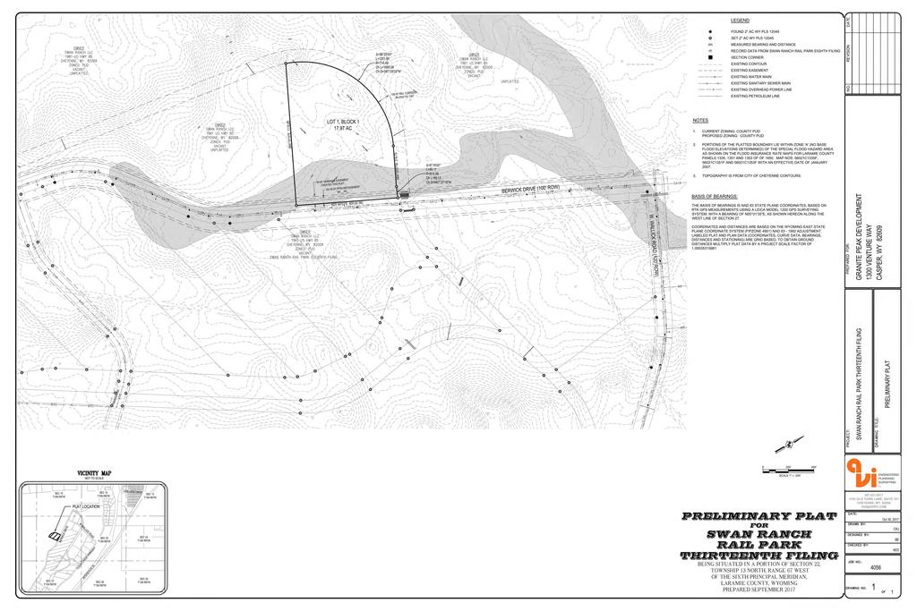
1 LARAMIE COUNTY PLANNING & DEVELOPMENT DEPARTMENT Planning Building MEMORANDUM TO: FROM: Laramie County Planning Commission Nancy M. Trimble, Associate Planner DATE: November 9, 2017 TITLE: Review and action of a Subdivision Permit and Plat for Swan Ranch Rail Park, Thirteenth Filing, in a portion of Section 22, T.13N., R.67W., of the 6th P.M., Laramie County WY. EXECUTIVE SUMMARY AVI, PC, on behalf of Swan Ranch LLC, has submitted a Subdivision Permit and Plat application for approval of Swan Ranch Rail Park,Thirteenth Filing, for a portion of Section 22, T.13N., R.67W., of the 6th P.M., Laramie County WY, located west of Berwick Drive and south of West Wallick Road. The application has been submitted for the purpose of platting a lot for a new tenant. BACKGROUND The proposed project would subdivide approximately 18 acres as a single lot from an unplatted property of 1,920 acres in the Swan Ranch Rail Park development area, located southwest of Otto Road and the I-25 Interstate. This subdivision is occurring within a mile of the City and requires Governing Body review (W.S (b) and approval. This plat has been submitted to the City and is processing concurrently with the County. Pertinent Regulations Section (a-e) of the Laramie County Land Use Regulations governing the criteria for a subdivision permit and plat. Section of the Laramie County Land Use Regulations governing the PUD Planned Unit Development zone district; more specifically, the Swan Ranch Rail Park North PUD Archer Pkwy Cheyenne, WY Phone (307) Fax (307)
2 DISCUSSION The Laramie County Comprehensive Plan identifies the area as Urban Rural Interface (URI), which is intended to accommodate a mix of more intensive land uses than other areas. PlanCheyenne contemplates Industrial as the future land use. The Industrial category provides for a range of employment-focused uses, which may have impacts such as noise, outdoor storage, and freight needs that make them incompatible in other areas of the community. The property is zoned Planned Unit Development (PUD); more specifically, Swan Ranch North PUD. This zone allows for industrial, community open space, and commercial uses. The Swan Ranch North PUD does not establish minimum or maximum lot size, but rather setbacks, open space, and landscaping requirements based on lot size and building coverage percentages. A request for waiver of the drainage and traffic studies was submitted with the application. The County Engineer has concurred with the waiver request, as a site plan application submittal will be required and will ensure that drainage and traffic impacts are evaluated. A development action sign was posted on the property and notifications were sent to the adjacent property owners regarding the application. No comments were received from the public. Staff received agency comments confirming the application is in process with the City, and requiring mapping revisions. A revised plat was submitted on October 30, 2017 and has been included with this staff report. The attached resolution shall serve as the Subdivision Permit upon approval by the Board. Staff finds the proposal to be in general conformance with the plans and policies of the Laramie County Land Use Regulations, PlanCheyenne, and the Swan Ranch Rail Park North PUD zone district. RECOMMENDATION and FINDINGS Based on evidence provided, staff recommends the Planning Commission find that: a. This application meets the criteria for a subdivision permit and plat pursuant to section (a-e) of the Laramie County Land Use Regulations. b. This application is in conformance with the Swan Ranch Rail Park North PUD zone district. and that the Planning Commission recommend approval of the Subdivision Permit and Plat for Swan Ranch Rail Park, Thirteenth Filing, in a portion of Section 22, T.13N., R.67W., of the 6th P.M., Laramie County WY, to the Laramie County Board of Commissioners with no conditions Archer Pkwy Cheyenne, WY Phone (307) Fax (307)
3 PROPOSED MOTION I move to recommend approval of the Subdivision Permit and Plat for Swan Ranch Rail Park, Thirteenth Filing, to the Laramie County Board of Commissioners with no conditions and adopt the findings of facts a and b of the staff report. ATTACHMENTS Attachment 1: Location Map Attachment 2: Aerial Map Attachment 3: Comprehensive Plan Map Attachment 4: PlanCheyenne Map Attachment 5: Zoning Map Attachment 6: Agency Review Comments Report Attachment 7: Draft Resolution Attachment 8: Revised Plat October 30, Archer Pkwy Cheyenne, WY Phone (307) Fax (307)
4 WAGON RD GANNETT PEAK DR I-25 BROKEN ARROW RD Laramie County, Wyoming 4900 GRANITE PEAK DR SWAN RANCH RAIL PARK THIRTEENTH FILING SUBDIVISION PERMIT AND PLAT 5648 BERWICK DR DR BERWICK B RIDGERPEAK 5310 CLEAR CREEK PKWY RD 4930 CLEAR CREEK PKWY CHEYENNE 4221 CLEAR CREEK PKWY I-25 COUNTY I I-25 Legend PZ Location Map Property Lines Current Flood Hazards NAME FEMA FLOODWAY FEMA 100YR FLOODPLAIN FEMA 500YR FLOODPLAIN CITY/CNTY 100YR FLOODPLAIN Cities & Towns TOWN ALBIN BURNS CHEYENNE PINE BLUFFS Approximate Plat Area 6193 BERWICK DR TUNDRA DR 6099 TUNDRA DR 6208 CLEAR CREEK PKWY CLEAR CREEK HIGH PLAINS RD 5720 PKWY I-25 I-25 United States Department of Agriculture Printed on Oct 04, ,900 Feet This map is made possible through the Cheyenne and Laramie County Cooperative GIS Program (CLCCGIS). The data contained herein was collected for its use and is for display and planning purposes only. The CLCCGIS will not be held liable as to the validity, correctness, accuracy, completeness, and/or reliability of the data. The CLCCGIS furthermore assumes no liability associated with the use or misuse of this information.
5 4900 Laramie County, Wyoming SWAN RANCH RAIL PARK THIRTEENTH FILING SUBDIVISION PERMIT AND PLAT PZ Aerial Map COUNTY CHEYENNE Legend Property Lines Current Flood Hazards NAME FEMA FLOODWAY FEMA 100YR FLOODPLAIN FEMA 500YR FLOODPLAIN CITY/CNTY 100YR FLOODPLAIN Cities & Towns TOWN ALBIN BURNS CHEYENNE PINE BLUFFS Approximate Plat Area BERWICK DR Printed on Oct 04, BRIDGER PEAK RD United States Department of Agriculture Feet This map is made possible through the Cheyenne and Laramie County Cooperative GIS Program (CLCCGIS). The data contained herein was collected for its use and is for display and planning purposes only. The CLCCGIS will not be held liable as to the validity, correctness, accuracy, completeness, and/or reliability of the data. The CLCCGIS furthermore assumes no liability associated with the use or misuse of this information.
6 4900 Laramie County, Wyoming SWAN RANCH RAIL PARK THIRTEENTH FILING SUBDIVISION PERMIT AND PLAT PZ Comprehensive Plan Map Approximate Plat Area URI Legend Property Lines Future Land Use Districts OTHER Urban-Rural Interface (URI) Rural Metro (RM) Rural Ag Interface (RAI) Ag & Range Land (AGR) BERWICK DR Printed on Oct 04, BRIDGER PEAK RD United States Department of Agriculture Feet This map is made possible through the Cheyenne and Laramie County Cooperative GIS Program (CLCCGIS). The data contained herein was collected for its use and is for display and planning purposes only. The CLCCGIS will not be held liable as to the validity, correctness, accuracy, completeness, and/or reliability of the data. The CLCCGIS furthermore assumes no liability associated with the use or misuse of this information.
7 OS 4900 Laramie County, Wyoming SWAN RANCH RAIL PARK THIRTEENTH FILING SUBDIVISION PERMIT AND PLAT IND PZ PlanCheyenne Map Legend Approximate Plat Area BERWICK DR MU-E Property Lines PlanCheyenne (2014) NEW_FLUP Agriculture/Rural Rural Residential Urban Transition Residential Urban Residential Mixed-use Residential MU-E Industrial Mixed-use Commercial Community Business Central Business District Public and Quasi-Public PUB-FED Open Space and Parks ROW Printed on Oct 04, BRIDGER PEAK RD United States Department of Agriculture Feet This map is made possible through the Cheyenne and Laramie County Cooperative GIS Program (CLCCGIS). The data contained herein was collected for its use and is for display and planning purposes only. The CLCCGIS will not be held liable as to the validity, correctness, accuracy, completeness, and/or reliability of the data. The CLCCGIS furthermore assumes no liability associated with the use or misuse of this information.
8 LIGHT INDUSTRIAL 4900 Laramie County, Wyoming SWAN RANCH RAIL PARK THIRTEENTH FILING SUBDIVISION PERMIT AND PLAT PLANNED UNIT DEVELOPMENT BERWICK DR PLANNED UNIT DEVELOPMENT Legend PZ Zoning Map Property Lines All Other Values Archer Special Use District (ASU) Agricultural (A-2) Agricultural and Rural Residental (A-1) Agricultural Residentail (AR) Low Density Residential - Established (LR-1) Low Density Residential - Developing (LR-2) MR Medium Density Residential - Established (MR-1) Medium Density Residential - Developing (MR-2) High Density Residential - Established (HR-1) High Density Residentiial - Developing (HR-2) MU Mixed Use with Residential Emphasis (MUR) Mixed Use with Business Emphasis (MUB) Neighborhood Business Community Business (CB) Light Industrial (LI) Heavy Industrial (HI) Public (P) Planned Unit Development (PUD) Military (M) Approximate Plat Area Printed on Oct 04, 2017 BRIDGER PEAK RD LIGHT INDUSTRIAL United States Department of Agriculture Feet This map is made possible through the Cheyenne and Laramie County Cooperative GIS Program (CLCCGIS). The data contained herein was collected for its use and is for display and planning purposes only. The CLCCGIS will not be held liable as to the validity, correctness, accuracy, completeness, and/or reliability of the data. The CLCCGIS furthermore assumes no liability associated with the use or misuse of this information.
9 PZ SWAN RANCH RAIL PARK 13 TH FILING SUB PERMIT/PLAT Cheyenne Development Services: Lisa Pafford COMMENTS ATTACHED 10/16/2017 This subdivision is occurring within a mile of the City and requires Governing Body review (W.S (b) and approval. This plat has been submitted to the City and is processing concurrently with the County. County Real Estate Office: Laura Pate COMMENTS ATTACHED 10/13/2017 Should there be an Approval from County Planning and the Commissioners in addition to the Approval that is on there for the City? County Engineer: Scott Larson COMMENTS ATTACHED 10/19/2017 Engineer Review 1. I assume the shaded area on the plat drawing is the FEMA special flood hazard area but it is not labeled as such. Please add a label as to what the shaded area is. 2. I concur with the request for a waiver of a detailed Drainage Study and Traffic Study as they shall be included with the Site Plan application. Surveyor Review 1. Plat requirements include signature blocks for use by the Chairman of the Planning Commission, the Chairman of the Board and County Clerk for Laramie County, Wyoming, as well as the Mayor and Clerk of the appropriate city or town, should the subdivision/development be located within one (1) mile of the city/town limits. Signature blocks are not provided for Chairman of the Board or County Clerk. 2. Plat layouts require a vicinity map indicating the location of the proposed subdivision development with respect to the surrounding area. The Vicinity Map would be easier to read and it would be more useful to the lay public if one were to add some information such as, at a minimum, the Section, Township and Range data with enough detail to indicate the location of the subdivision within the Section. It is helpful to identify where the subdivision is located with respect to nearest well known community or significant area feature that the general public is familiar with and can relate to. 3. Plat layouts require any recorded easements or restrictions applicable to the subdivision shall be noted by reference to Register s book and page number. The County will not be involved in the enforcement of deed restriction or covenant instruments. The origins of the Existing DRAINAGE EASEMENT and the Existing PIPELINE EASEMENT are not indicated on the plat. Are they shown on another plat or should there be a Register s book and page number shown? The Register s book and page number for the Rail Corridor are shown as BOOK PAGE 1358 on the drawing and in the LEGAL DESCRIPTION as BOOK In the area where the Public Land Survey Corner ties are shown, the word UNPLATTED is placed in the same location as the bearing and distance tie between the Public Land Survey Corners, making them difficult to read. 5. I did not see any mention of irrigation water rights on the subdivision so I assume there aren t any. Planner: Nancy Trimble COMMENTS ATTACHED 10/19/2017 Clerical errors on the plat shall be corrected prior to recordation.
10 Agencies responding with No Comment: Board of Public Utilities, Cheyenne MPO, County Assessor, Environmental Health Dept., WYDOT, Fire District No. 1, Cheyenne Light Fuel & Power, Building Dept. Agencies not responding: County Public Works Dept., County Treasurer, US Post Office, Combined Communications Center, Emergency Management, Sheriff s Office, Cheyenne Engineering Services.
11 RESOLUTION NO. A RESOLUTION TO APPROVE A SUBDIVISION PERMIT AND PLAT FOR SWAN RANCH RAIL PARK, THIRTEENTH FILING, IN A PORTION OF SECTION 22, T.13N., R.67W., OF THE 6TH P.M., LARAMIE COUNTY WY. WHEREAS, Wyoming State Statutes to ; to authorize Laramie County, in promoting the public health, safety, morals and general welfare of the county, to regulate the use of land through zoning in unincorporated Laramie County; and WHEREAS, the Laramie County Board of Commissioners adopted the Laramie County Land Use Regulations; and WHEREAS, the proposed subdivision and plat is in accordance with section (a-e) of the Laramie County Land Use Regulations; and WHEREAS, the proposed subdivision is in conformance with the plans and policies of the Swan Ranch Rail Park North PUD zone district; and WHEREAS, this resolution is the subdivision permit for Swan Ranch Rail Park, Thirteenth Filing. NOW THEREFORE BE IT RESOLVED BY THE GOVERNING BODY OF LARAMIE COUNTY, WYOMING, as follows: The Laramie County Board of Commissioners finds that: a. This application is in conformance with section (a-e) of the Laramie County Land Use Regulations. b. This application is in conformance with the Swan Ranch Rail Park North PUD zone district. And the Board approves the Subdivision Permit and Plat for Swan Ranch Rail Park, Thirteenth Filing. PRESENTED, READ AND ADOPTED THIS DAY OF, LARAMIE COUNTY BOARD OF COMMISSIONERS ATTEST: Troy Thompson, Chairman Debra K. Lee, Laramie County Clerk Reviewed and approved as to form: Mark T. Voss, Laramie County Attorney
12
LARAMIE COUNTY PLANNING & DEVELOPMENT DEPARTMENT
 LARAMIE COUNTY PLANNING & DEVELOPMENT DEPARTMENT Planning Building MEMORANDUM TO: FROM: Laramie County Board of Commissioners Nancy M. Trimble, Associate Planner DATE: December 5, 2017 TITLE: Review and
LARAMIE COUNTY PLANNING & DEVELOPMENT DEPARTMENT
 LARAMIE COUNTY PLANNING & DEVELOPMENT DEPARTMENT Planning Building MEMORANDUM TO: FROM: Laramie County Planning Commission Nancy M. Trimble, Associate Planner DATE: November 9, 2017 TITLE: Review and action
LARAMIE COUNTY PLANNING & DEVELOPMENT DEPARTMENT
 LARAMIE COUNTY PLANNING & DEPARTMENT Planning Building MEMORANDUM TO: FROM: Laramie County Planning Commission Nancy M. Trimble, Associate Planner DATE: December 14, 2017 TITLE: Review and action of a
LARAMIE COUNTY PLANNING & DEVELOPMENT DEPARTMENT
 LARAMIE COUNTY PLANNING & DEVELOPMENT DEPARTMENT Planning Building MEMORANDUM TO: FROM: Laramie County Planning Commission Bryan Nicholas, Associate Planner DATE: February 14, 2019 TITLE: Review and action
LARAMIE COUNTY PLANNING & DEVELOPMENT DEPARTMENT
 LARAMIE COUNTY PLANNING & DEVELOPMENT DEPARTMENT Planning Building MEMORANDUM TO: FROM: Laramie County Planning Commission Nancy Trimble, Associate Planner DATE: July 13, 2017 TITLE: Review and action
LARAMIE COUNTY PLANNING & DEVELOPMENT DEPARTMENT
 LARAMIE COUNTY PLANNING & DEVELOPMENT DEPARTMENT Planning Building MEMORANDUM TO: FROM: Laramie County Planning Commission Bryan Nicholas, Associate Planner DATE: November 9, 2017 TITLE: Review and action
LARAMIE COUNTY PLANNING & DEVELOPMENT DEPARTMENT
 LARAMIE COUNTY PLANNING & DEVELOPMENT DEPARTMENT Planning Building MEMORANDUM TO: FROM: Laramie County Board of Commissioners Bryan Nicholas, Associate Planner DATE: May 15, 2018 TITLE: Review and action
LARAMIE COUNTY PLANNING & DEVELOPMENT DEPARTMENT
 LARAMIE COUNTY PLANNING & DEVELOPMENT DEPARTMENT Planning Building MEMORANDUM TO: FROM: Laramie County Planning Commission Nancy M. Trimble, Associate Planner DATE: July 13, 2017 TITLE: Review and action
LARAMIE COUNTY PLANNING & DEVELOPMENT DEPARTMENT
 LARAMIE COUNTY PLANNING & DEVELOPMENT DEPARTMENT Planning Building MEMORANDUM TO: FROM: Laramie County Planning Commission Bryan Nicholas, Associate Planner DATE: April 11, 2019 TITLE: Review and action
LARAMIE COUNTY PLANNING & DEVELOPMENT DEPARTMENT
 LARAMIE COUNTY ANNING & DEVELOPMENT DEPARTMENT Planning Building MEMORANDUM TO: FROM: Laramie County Board of Commissioners Seth Frentheway, Associate Planner DATE: June 19 th, 2018 TITLE: Review and action
LARAMIE COUNTY PLANNING & DEVELOPMENT DEPARTMENT
 LARAMIE COUNTY PLANNING & DEVELOPMENT DEPARTMENT Planning Building MEMORANDUM TO: FROM: Laramie County Board of Commissioners Bryan Nicholas, Associate Planner DATE: October 2, 2018 TITLE: Review and action
LARAMIE COUNTY PLANNING & DEVELOPMENT DEPARTMENT
 LARAMIE COUNTY PLANNING & DEVELOPMENT DEPARTMENT Planning Building MEMORANDUM TO: FROM: Laramie County Planning Commission Marissa Pomerleau, Planning Technician DATE: March 28, 2019 TITLE: Review and
LARAMIE COUNTY PLANNING & DEVELOPMENT DEPARTMENT
 LARAMIE COUNTY PLANNING & DEVELOPMENT DEPARTMENT Planning Building MEMORANDUM TO: FROM: Laramie County Board of Commissioners Nancy Trimble, Associate Planner DATE: July 18, 2017 TITLE: Review and action
LARAMIE COUNTY PLANNING & DEVELOPMENT DEPARTMENT
 LARAMIE COUNTY PLANNING & DEVELOPMENT DEPARTMENT Planning Building MEMORANDUM TO: FROM: Laramie County Board of Commissioners Brad Emmons, Planning Director DATE: May 15, 2018 TITLE: Review and action
LARAMIE COUNTY PLANNING & DEVELOPMENT DEPARTMENT
 LARAMIE COUNTY PLANNING & DEVELOPMENT DEPARTMENT Planning Building MEMORANDUM TO: FROM: Laramie County Planning Commission Brett Walker, Planner DATE: January 25, 2018 TITLE: Review and action of a Subdivision
LARAMIE COUNTY PLANNING & DEVELOPMENT DEPARTMENT
 LARAMIE COUNTY PLANNING & DEVELOPMENT DEPARTMENT Planning Building MEMORANDUM TO: FROM: Laramie County Planning Commission Jean Vetter, Senior Planner DATE: January 26, 2017 TITLE: Review and action of
LARAMIE COUNTY PLANNING & DEVELOPMENT DEPARTMENT
 LARAMIE COUNTY PLANNING & DEVELOPMENT DEPARTMENT Planning Building MEMORANDUM TO: FROM: Laramie County Planning Commission Seth Frentheway, Associate Planner DATE: November 8, 2018 TITLE: Review and action
LARAMIE COUNTY PLANNING & DEVELOPMENT DEPARTMENT
 LARAMIE COUNTY PLANNING & DEVELOPMENT DEPARTMENT Planning Building MEMORANDUM TO: FROM: Laramie County Planning Commission Brad Emmons, Planning Director DATE: March 22, 2018 TITLE: Review and recommendations
LARAMIE COUNTY PLANNING & DEVELOPMENT DEPARTMENT
 LARAMIE COUNTY PLANNING & DEVELOPMENT DEPARTMENT Planning Building MEMORANDUM TO: FROM: Laramie County Planning Commission Brett Walker, Planner DATE: January 25, 2018 TITLE: Review and action of a Variance
LARAMIE COUNTY PLANNING & DEVELOPMENT DEPARTMENT
 LARAMIE COUNTY PLANNING & DEVELOPMENT DEPARTMENT Planning Building MEMORANDUM TO: FROM: Laramie County Planning Commission Seth Frentheway, Associate Planner DATE: August 23, 2018 TITLE: Review and recommendations
LARAMIE COUNTY PLANNING & DEVELOPMENT DEPARTMENT
 LARAMIE COUNTY PLANNING & DEVELOPMENT DEPARTMENT Planning Building MEMORANDUM TO: FROM: Laramie County Planning Commission Seth Frentheway, Associate Planner DATE: August 23, 2018 TITLE: Review and action
ORDINANCE NO. BE IT ORDAINED BY THE GOVERNING BODY OF THE CITY OF CHEYENNE, WYOMING:
 ORDINANCE NO. ENTITLED: AN ORDINANCE PURSUANT TO SECTION 2.2.1, ZONING MAP AMENDMENT, 2.2.2, PLANNED DEVELOPMENT REGULATING PLAN OR DEVELOPMENT MASTER PLAN, SECTION 5.1.2, ZONING DISTRICTS ESTABLISHED,
LARAMIE COUNTY PLANNING & DEVELOPMENT DEPARTMENT
 LARAMIE COUNTY PLANNING & DEVELOPMENT DEPARTMENT Planning Building MEMORANDUM TO: FROM: Laramie County Planning Commission Bryan Nicholas, Associate Planner DATE: September 27, 2018 TITLE: Review and action
LARAMIE COUNTY PLANNING & DEVELOPMENT DEPARTMENT
 LARAMIE COUNTY PLANNING & DEVELOPMENT DEPARTMENT Planning Building MEMORANDUM TO: FROM: Laramie County Board of Commissioners Bryan Nicholas, Associate Planner DATE: October 16, 2018 TITLE: Review and
Minutes of the Proceedings Laramie County Planning Commission Prepared by the Laramie County Planning & Development Office Laramie County Wyoming
 Minutes of the Proceedings Laramie County Planning Commission Prepared by the Laramie County Planning & Development Office Laramie County Wyoming Thursday, January 12, 2012 120112 00 The Laramie County
ORDINANCE NO. BE IT ORDAINED BY THE GOVERNING BODY OF THE CITY OF CHEYENNE, WYOMING: That the City of Cheyenne hereby finds as follows:
 ORDINANCE NO. ENTITLED: AN ORDINANCE ANNEXING TO THE CITY OF CHEYENNE, WYOMING, A PARCEL OF LAND SITUATED IN THE NORTH 102 FEET OF TRACTS 323 AND 324, SUNNYSIDE ADDITION, 7TH FILING, LARAMIE COUNTY, WYOMING
PLANNED UNIT DEVELOPMENT & SUBDIVISION STAFF REPORT Date: September 15, 2016
 # 10 SUB2016-00089 PLANNED UNIT DEVELOPMENT & SUBDIVISION STAFF REPORT Date: September 15, 2016 NAME SUBDIVISION NAME LOCATION Lot 12 Laughlin Industrial Park Subdivision Lot 12 Laughlin Industrial Park
Guide to Replats. Step 1. Step 2. Step 3. Step 4. Step 5. Step 6. Step 7. Step 8. Step 9. Step 10
 Guide to Replats Introduction Douglas County is committed to providing open, transparent application processes to the public. This Guide is provided to assist anyone interested in the procedures and expectations
Minutes of the Proceedings Laramie County Planning Commission Prepared by the Laramie County Planning & Development Office Laramie County Wyoming
 Minutes of the Proceedings Laramie County Planning Commission Prepared by the Laramie County Planning & Development Office Laramie County Wyoming Thursday, April 10, 2014 140410 00 The Laramie County Planning
BE IT ORDAINED BY THE GOVERNING BODY OF THE CITY OF CHEYENNE, WYOMING: FIRST READING: SECOND READING: 3RD AND FINAL READING:
 ORDINANCE NO. ENTITLED: AN ORDINANCE PURSUANT TO SECTION 2.2.1 ZONING MAP AMENDMENTS, SECTION 5.1.2 ZONING DISTRICTS ESTABLISHED, AND SECTION 5.1.3 OFFICIAL ZONING MAP, OF THE UNIFIED DEVELOPMENT CODE,
Guide to Combined Preliminary and Final Plats
 Guide to Combined Preliminary and Final Plats Introduction The Douglas County is committed to providing open, transparent application processes to the public. This Guide is provided to assist anyone interested
The Laramie County Land Use Regulations
 LARAMIE COUNTY, WYOMING Formatted The Laramie County Land Use Regulations Title 2 County-Wide Land use Regulations 5/24/2018 pg. Adopted February 15, 2011 Table of Contents Title 2 County Wide Land Use
Guide to Minor Developments
 Guide to Minor Developments Introduction The Douglas County (DCD) is committed to providing open, transparent application processes to the public. This Guide is provided to assist anyone interested in
B. The proposed parcel(s) of land shall be in compliance with the current zoning requirements.
 of land shall be in compliance with the current zoning requirements.") SECTION 14-900 SUBDIVISION EXEMPTION 14-901 INTENT To establish criteria and a review process whereby the Board of County Commissioners may grant Exemptions from the definition of the terms subdivision
SECTION 14-900 SUBDIVISION EXEMPTION 14-901 INTENT To establish criteria and a review process whereby the Board of County Commissioners may grant Exemptions from the definition of the terms subdivision
MINOR PLAT FILING APPLICATION
 FILING APPLICATION Date of PC Meeting: Date of BCC Meeting: Fee Paid: 1. APPLICANT: DAYTIME PHONE: MAILING ADDRESS: LANDOWNER: DAYTIME PHONE: MAILING ADDRESS: AUTHORIZED AGENT: MAILING ADDRESS: RELATIONSHIP
Larimer County Planning Dept. Procedural Guide for 1041 PERMITS
 - Larimer County Planning Dept. Procedural Guide for 1041 PERMITS PLEASE NOTE: A PRE-APPLICATION CONFERENCE IS REQUIRED PRIOR TO SUBMITTING THIS APPLICATION. PURPOSE: State Statutes allow local governments
ZONING AMENDMENT & SUBDIVISION STAFF REPORT Date: March 1, 2018
 #13 SUB-000406-2018 & ZON-000407-2018 ZONING AMENDMENT & SUBDIVISION STAFF REPORT Date: March 1, 2018 NAME SUBDIVISION NAME LOCATION Creekside @ Kooiman Dairy Creekside @ Kooiman Dairy Subdivision (South
MAJOR RESIDENTIAL AND NONRESIDENTIAL SUBDIVISIONS
 Lawrence-Douglas County MAJOR RESIDENTIAL AND NONRESIDENTIAL SUBDIVISIONS Preliminary Plats The applicant shall schedule a Pre-Application meeting with Planning Staff at least seven (7) working days prior
AGENDA ITEM SUMMARY BUSINESS OF THE CITY COUNCIL CITY OF GOLDEN, COLORADO. Quasi Judicial Matter
 AGENDA ITEM SUMMARY BUSINESS OF THE CITY COUNCIL CITY OF GOLDEN, COLORADO Quasi Judicial Matter MEETING DATE: July 10, 2014 REPORT DATE: June 30, 2014 CASE NO: PC 14-26 DEPT. OF ORIGIN: Community and Economic
Guide to Preliminary Plans
 Guide to Preliminary Plans Introduction The Douglas County is committed to providing open, transparent application processes to the public. This Guide is provided to assist anyone interested in the procedures
TO: Glynn County Islands Planning Commission. Eric Landon, Planner II. PP2754 Stones Throw Cottages. DATE: February 6, 2014
 COMMUNITY DEVELOPMENT DEPARTMENT Planning and Zoning Division 1725 Reynolds Street, Suite 200, Brunswick, GA 31520 Phone: 912-554-7428/Fax: 1-888-252-3726 TO: Glynn County Islands Planning Commission FROM:
MTC ALABAMA SUBDIVISION
 # 2 SUB-000370-2017 MTC ALABAMA SUBDIVISION Engineering Comments: FINAL PLAT COMMENTS (should be addressed prior to submitting the FINAL PLAT for review and/or signature by the City Engineer): A. Provide
DAUPHIN CREEK ESTATES SUBDIVISION
 # 12 SUB-000076-2017 DAUPHIN CREEK ESTATES SUBDIVISION Engineering Comments: FINAL PLAT COMMENTS (should be addressed prior to submitting the FINAL PLAT for review and/or signature by the City Engineer):
SUBDIVISION, PLANNING APPROVAL, & REZONING STAFF REPORT Date: June 4, 2015
 SUBDIVISION, PLANNING APPROVAL, & REZONING STAFF REPORT Date: June 4, 2015 APPLICANT NAME SUBDIVISION NAME DEVELOPMENT NAME LOCATION Board of Water & Sewer Commissioners of the City of Mobile MAWSS MLK
CITY OF FAYETTEVILLE, ARKANSAS FINAL PLAT FOR STAFF USE ONLY FINAL PLAT FEE: $ $ Date Application Submitted: Date Accepted as Complete:
 CITY OF FAYETTEVILLE, ARKANSAS FINAL PLAT FOR STAFF USE ONLY FINAL PLAT FEE: $200.00-$800.00 Date Application Submitted: Date Accepted as Complete: Project Number: Public Hearing S-T-R: PP#: Zone: Please
SUBDIVISION, PLANNED UNIT DEVELOPMENT, & REZONING STAFF REPORT Date: September 17, 2015
 SUBDIVISION, PLANNED UNIT DEVELOPMENT, & REZONING STAFF REPORT Date: September 17, 2015 APPLICANT NAME SUBDIVISION NAME DEVELOPMENT NAME LOCATION Daniel Clark Mack Manufacturing Subdivision, Resubdivision
WESTON COUNTY FINAL PLAT APPLICATION
 WESTON COUNTY FINAL PLAT APPLICATION Property Owner: Mailing Address of owner: Telephone Number(s) of owner: Property Owner: Mailing Address of owner: Telephone Number(s) of owner: (If subdivider/applicant
Final Plat Approval of a Minor Subdivision Application Packet
 Final Plat Approval of a Minor Subdivision Application Packet 1. Application Packet. Be sure to complete and submit all the required materials that are a part of this Application Packet. Failure to do
STAFF REPORT - SUMMATION. Saddle Ridge, 7 th Filing. Preliminary Plat Process CASE NUMBER: UDC SUBDIVISION CODE: SDRA-P
 STAFF REPORT - SUMMATION Saddle Ridge, 7 th Filing Preliminary Plat Process CASE NUMBER: UDC-15-00351 SUBDIVISION CODE: SDRA-P PREPARED BY: MEETING DATES: Josh Tetzlaff July 6, 2015 Planning Commission
A lot line or terminology adjustment will be reviewed concurrently with any other development review application(s) that are required.
 that are required.") RELATED FACTS TO KNOW: Adams County Recording Requirements, Annexation, Common Wall Subdivision, Development Plan (PUD Development Permit), Fees, Helpful Contact Information, Neighborhood Meeting, Park
RELATED FACTS TO KNOW: Adams County Recording Requirements, Annexation, Common Wall Subdivision, Development Plan (PUD Development Permit), Fees, Helpful Contact Information, Neighborhood Meeting, Park
Oakland County Michigan Register of Deeds Plat Engineering, GIS, & Remonumentation Dept. Ph: (248) Fax (248)
 Fax (248)") Oakland County Michigan Register of Deeds Plat Engineering, GIS, & Remonumentation Dept. Ph: (248)-858-1447 Fax (248)-858-7466 Requirements Needed for Final Plat Approval No. General Requirements. 1 Routing
Oakland County Michigan Register of Deeds Plat Engineering, GIS, & Remonumentation Dept. Ph: (248)-858-1447 Fax (248)-858-7466 Requirements Needed for Final Plat Approval No. General Requirements. 1 Routing
Final Plat Approval of a Major Subdivision Application Packet
 Final Plat Approval of a Major Subdivision Application Packet 1. Application Packet. Be sure to complete and submit all the required materials that are a part of this Application Packet. Failure to do
ZONING AMENDMENT, PLANNED UNIT DEVELOPMENT & SUBDIVISION STAFF REPORT Date: August 8, 2013
 ZONING AMENDMENT, PLANNED UNIT DEVELOPMENT & SUBDIVISION STAFF REPORT Date: August 8, 2013 NAME SUBDIVISION NAME PV-Magnolia, LLC Twelve Trees Subdivision LOCATION 2860, 2862 and 2866 Pleasant Valley Road
City of Leavenworth DEPARTMENT OF DEVELOPMENT SERVICES MAJOR SUBDIVISION APPLICATION 1
 Proposed Name of Subdivision: City of Leavenworth DEPARTMENT OF DEVELOPMENT SERVICES MAJOR SUBDIVISION APPLICATION 1 FOR PRELIMINARY SUBDIVISION APPROVAL This application must be filled out legibly, in
Staff Report: Date: Applicant: Property Identification: Acreage of Request: Current Zoning of Requested Area: Requested Action: Attached:
 Staff Report: Completed by Jeff Palmer Director of Planning & Zoning Date: November 7, 2018, Updated November 20, 2018 Applicant: Greg Smith, Oberer Land Developer agent for Ronald Montgomery ET AL Property
BOARD OF COUNTY COMMISSIONERS ARCHULETA COUNTY, COLORADO RESOLUTION 2018-
 BOARD OF COUNTY COMMISSIONERS ARCHULETA COUNTY, COLORADO RESOLUTION 2018- ARCHULETA COUNTY IMPROPERLY DIVIDED PARCELS EXEMPTION INTERIM RESOLUTION - A RESOLUTION ADDRESSING PARCELS UNDER THE SIZE OF 35
PLANNING & DEVELOPMENT
 PLANNING & DEVELOPMENT STAFF REPORT Rezoning PETITION: APPLICANT: PROPERTY OWNER: TYPE OF REQUEST: SIZE OF TRACT: LOCATION: (#17-22) Rezone from A-PUD (Agri-Business Planned Unit Development) to A-PUD
INSTRUCTIONS FINAL PLAT APPROVAL APPLICATION
 INSTRUCTIONS FINAL PLAT APPROVAL APPLICATION 1. The applicant/agent shall fill out the attached application. The attached application form must be completely filled in before it can be filed. Portions
ARTICLE 900 PLAT AND PLAN REQUIREMENTS
 ARTICLE 900 PLAT AND PLAN REQUIREMENTS SEC. 900.1 ITEMS TO BE SHOWN ON PLAT OR PLAN General (1) Property lines of all property owners adjacent to the exterior boundaries of the project shall be located
MUNICIPAL BUILDING 2101 O Neil Avenue Cheyenne, WY
 MUNICIPAL BUILDING 2101 O Neil Avenue Cheyenne, WY 82001 http://www.cheyennecity.org To view agenda backup items select the following link: http://cheyenne.granicus.com/generatedagendaviewer.php?view_id=5&event_id=687
A Final Plat will be reviewed concurrently with any other development review application(s) that is required.
 that is required.") RELATED FACTS TO KNOW: Adams County Recording Requirements, Annexation, Common Wall Subdivision, Development Plan (PUD Development Permit), Fees, Helpful Contact Information, Lot Line Adjustment, Neighborhood
RELATED FACTS TO KNOW: Adams County Recording Requirements, Annexation, Common Wall Subdivision, Development Plan (PUD Development Permit), Fees, Helpful Contact Information, Lot Line Adjustment, Neighborhood
Article 6: Planned Unit Developments
 LUDC 2013 GARFIELD COUNTY, COLORADO Article 6: Planned Unit Developments ARTICLE 6 PLANNED UNIT DEVELOPMENTS TABLE OF CONTENTS DIVISION 1. GENERAL.... 1 6-101. GENERAL PROVISIONS.... 1 A. Purpose....
CITY OF PAPILLION MAYOR AND CITY COUNCIL REPORT APRIL 3, 2018 AGENDA. Subject: Type: Submitted By: Resolution #R
 CITY OF PAPILLION MAYOR AND CITY COUNCIL REPORT APRIL 3, 2018 AGENDA Subject: Type: Submitted By: A request for a Final Plat for the property legally described as Tax Lot 3 located in the NE 1/4 of the
BOSSIER CITY PARISH METROPOLITAN PLANNING COMMISSION 620 Benton Rd. Bossier City, LA Phone: Fax: PRELIMINARY PLAT
 (OFFICE USE ONLY) Application Fee: Paid: Date: CASE # Project Information BOSSIER CITY PARISH METROPOLITAN PLANNING COMMISSION 620 Benton Rd. Bossier City, LA 71111 Phone: 318-741-8824 Fax: 318-741-8827
Town of Prairie du Sac Sauk County, WI. Land Division Ordinance 07-3
 Town of Prairie du Sac Sauk County, WI Land Division Ordinance 07-3 1.01 DISCLAIMER (1) Multiple Jurisdictions. All persons reviewing the provisions of this Ordinance should be aware that the Town of Prairie
MINUTES OF THE TOWN OF LADY LAKE REGULAR PLANNING AND ZONING BOARD MEETING LADY LAKE, FLORIDA. May 8, :30 p.m.
 MINUTES OF THE TOWN OF LADY LAKE REGULAR PLANNING AND ZONING BOARD MEETING LADY LAKE, FLORIDA May 8, 2017 5:30 p.m. The Planning and Zoning Board Meeting was held in the Town Hall Commission Chambers at
Staff Report: Date: Applicant: Property Identification: Acreage of Request: Current Zoning of Requested Area: Requested Action: Attached:
 Staff Report: Completed by Jeff Palmer Director of Planning & Zoning Date: November 7, 2018 Applicant: Greg Smith, Oberer Land Developer agent for Ronald Montgomery ET AL Property Identification: Frontage
MINOR SUBDIVISION INFORMATION
 A. POINTS OF CONTACT: MINOR SUBDIVISION INFORMATION Surveyor: Address: Phone #: Fax # E-Mail Address: Representative (If different from applicant): Address: Phone #: Fax # E-Mail Address: B. GENERAL INFORMATION:
MAJOR SUBDIVISION PRELIMINARY PLAT CHECKLIST
 TOWNSHIP OF EGG HARBOR PLANNING BOARD/ZONING BOARD OF ADJUSTMENT 3515 BARGAINTOWN ROAD EGG HARBOR TOWNSHIP, NJ 08234 MAJOR SUBDIVISION PRELIMINARY PLAT CHECKLIST The following checklist is designed to
LARAMIE COUNTY PLANNING & DEVELOPMENT DEPARTMENT
 LARAMIE COUNTY PLANNING & DEVELOPMENT DEPARTMENT Planning Building MEMORANDUM TO: FROM: Laramie County Board of Commissioners Brett Walker, Planner DATE: April 3, 2018 TITLE: Review and action of a PUD
PLANNING AND ZONING COMMISSION VARIANCE
 PLANNING AND ZONING COMMISSION VARIANCE DOÑA ANA COUNTY COMMUNITY DEVELOPMENT DEPARTMENT Doña Ana County Government Center 845 N. Motel Blvd. Las Cruces, New Mexico 88007 Telephone: (575) 647-7350 MEETING
PLANNED UNIT DEVELOPMENT & SUBDIVISION STAFF REPORT Date: July 20, 2017
 PLANNED UNIT DEVELOPMENT & SUBDIVISION STAFF REPORT Date: July 20, 2017 DEVELOPMENT NAME SUBDIVISION NAME LOCATION Rangeline Crossing III Subdivision Rangeline Crossing III Subdivision 5289 Halls Mill
SKETCH PLAN REVIEW SPECIAL EXCEPTION, SPECIAL REVIEW,
 www.larimer.org Planning Department 200 W. Oak Street 3 rd Floor Fort Collins, CO 80521 970-498-7683 SKETCH PLAN REVIEW SKETCH PLAN REVIEW for Conservation Developments, Planned Land Divisions, Subdivisions,
Instructions for Maps to Accompany Proof of Appropriation and Beneficial Use of Ground Water
 Instructions for Maps to Accompany Proof of Appropriation and Beneficial Use of Ground Water Part II of the Proof of Appropriation (Form U.W. 8) All maps to accompany proof of appropriation and beneficial
City of Fort Lupton Amended Plat Process
 City of Fort Lupton Amended Plat Process Purpose The Amended Plat process is an administrative process to amend a recorded Plat. An Amended Subdivision is an administrative revision to a recorded Subdivision
FINAL PLAT APPLICATION
 FINAL PLAT APPLICATION (Page 1 of 3) LEGAL OWNER(s): NAME: STREET ADDRESS OWNER(s): CITY, STATE, ZIP CODE: PHONE NUMBER: BILLING ADDRESS: NAME OF ENGINEER/SURVEYOR: Engineer/Surveyor Address, Phone: PROPERTY
CHAPTER SHORT SUBDIVISIONS
 CITY OF MOSES LAKE MUNICIPAL CODE CHAPTER 17.09 SHORT SUBDIVISIONS Sections: 17.09.010 Purpose 17.09.020 Scope 17.09.030 Preliminary Short Subdivision Conditions and Requirements 17.09.040 Referral to
Community Development Department
 Community Development Department SUBJECT: Consideration of a Resolution for a Single-Lot Subdivision for the Skyler Park Subdivision at 626 Forest Road AGENDA ITEM: 9.b.v MEETING DATE: November 17, 2015
CERTIFICATION OF THE APPROVAL OF WATER AND SEWERAGE SYSTEMS
 ARTICLE 9 FORMS AND CHECK LISTS 9.100 On preliminary layout & final subdivision plat CERTIFICATION OF THE APPROVAL OF WATER AND SEWERAGE SYSTEMS I hereby certify that the (...type: private or pubic...)
SITE PLAN REVIEW ADMINISTRATIVE REVIEW. Please Note: Once submitted to the County, all application materials become a matter of public record.
 200 W. Oak Street, 3rd Floor Fort Collins, CO 80521 (970) 498-7683 / larimer.org/planning SITE PLAN REVIEW ADMINISTRATIVE REVIEW The submittal requirements listed in this packet are intended to collect
Plat Checklist PLAT TYPES AND DESCRIPTIONS
 Master Plan / Revision to Master Plan (For Platting Purposes Only) Preliminary/Final Plat Preliminary Plat Final Plat Minor Plat Replat Amended Plat Plat Checklist So that we may efficiently review your
PLANNING AND ZONING COMMISSION Planned Unit Development (PUD), Type 2
, Type 2") PLANNING AND ZONING COMMISSION Planned Unit Development (PUD), Type 2 DOÑA ANA COUNTY COMMUNITY DEVELOPMENT DEPARTMENT Doña Ana County Government Center 845 North Motel Blvd Las Cruces, New Mexico 88007
PLANNING AND ZONING COMMISSION Planned Unit Development (PUD), Type 2 DOÑA ANA COUNTY COMMUNITY DEVELOPMENT DEPARTMENT Doña Ana County Government Center 845 North Motel Blvd Las Cruces, New Mexico 88007
THE CITY OF MOBILE, ALABAMA
 THE CITY OF MOBILE, ALABAMA LETTER OF DECISION Dewberry I Preble-Rish 9949 Bellaton Avenue Daphne, AL 36526 Re: 6050 & 6086 Whitebark Drive (North side of Girby Road, 125'± East of Bristlecone Drive, extending
Whitney Ranch, 1 st Filing Annexation UDC P a g e 1
 STAFF REPORT - SUMMATION Whitney Ranch, 1 st Filing Annexation CASE NUMBER: UDC-17-00689 SUBDIVISION CODE: HIH 01 PREPARED BY: Eric Hammer PROPOSED CODE: WTRH 01 MEETING DATES: January 2, 2018 Planning
RE: File No. LD 1516 Certified Survey Map Tradewinds Parkway (B-R Enterprises of Madison, LLC)
") Department of Planning & Community & Economic Development Planning Division Katherine Cornwell, Director Madison Municipal Building, Suite LL-100 215 Martin Luther King, Jr. Boulevard P.O. Box 2985 Madison,
Department of Planning & Community & Economic Development Planning Division Katherine Cornwell, Director Madison Municipal Building, Suite LL-100 215 Martin Luther King, Jr. Boulevard P.O. Box 2985 Madison,
TO: Glynn County Islands Planning Commission. Karl W. Bursa, AICP, Planner II. PP3105 Stillwater Phase III. DATE: November 10, 2015
 COMMUNITY DEVELOPMENT DEPARTMENT Planning and Zoning Division 1725 Reynolds Street, Suite 200, Brunswick, GA 31520 Phone: 912-554-7428/Fax: 1-888-252-3726 TO: Glynn County Islands Planning Commission FROM:
Planning & Zoning Commission
 Planning & Zoning Commission Planning & Development Department August 14, 01 Zoning Map Amendment MAP-1-0001 (Bay View Section 4) Request Rezone approximately 1.19 acres from OS (Open Space) to RSF- (Residential
LAND USE PERMIT APPLICATION
 LAND USE PERMIT APPLICATION Date Application No. TYPE OF PERMIT Subdivision Short Plat Conditional Use Binding Site Plan Final Plat Final Short Plat Variance Final Binding Site Plan Plat Amendment Short
Bethel Romanian Church - Rezone, RZ
 / Planning and Zoning Staff Report Bethel Romanian Church - Rezone, RZ2018-0023 Hearing Date: November 15, 2018 Development Services Department Owners: Bethel Romanian Church, Corp. Applicant: Viorel Botos
For Office Use Only. Permit No. Fee: $ $ per proposed lot (AN ADDITIONAL 10% CODE COMPLIANCE FEE WILL BE CHARGED)
") For Office Use Only Permit No. Fee: $1600 + $560.00 per proposed lot (AN ADDITIONAL 10% CODE COMPLIANCE FEE WILL BE CHARGED) LAND PARTITION FOREST (Conditional Use) Crook County Planning Department 300
For Office Use Only Permit No. Fee: $1600 + $560.00 per proposed lot (AN ADDITIONAL 10% CODE COMPLIANCE FEE WILL BE CHARGED) LAND PARTITION FOREST (Conditional Use) Crook County Planning Department 300
IV. REVIEW PROCEDURES FOR MINOR SUBDIVISIONS
 IV. REVIEW PROCEDURES FOR MINOR SUBDIVISIONS IV-A. General Minor subdivisions create five or fewer lots from a tract of record, each lot of which has legal and physical access. If the tract of record proposed
Residential Subdivision Preliminary Plat Application
 WATER MODELING FEES Major : $650 or Minor : $550 # of lots x $35 per lot Residential Preliminary Plat Application Lots: 1-9 10-19 20-49 50-99 100-199 $300 $400 $475 $625 $825 200-349 350-499 500-499 700-999
PLANNING AND ZONING COMMISSION VARIANCE
 PLANNING AND ZONING COMMISSION VARIANCE DOÑA ANA COUNTY COMMUNITY DEVELOPMENT DEPARTMENT Doña Ana County Government Center 845 N. Motel Blvd. Las Cruces, New Mexico 88007 Telephone: (575) 647-7350 MEETING
City of Clever Planning & Zoning Department P.O. Box 52 Clever, MO QUALIFICATIONS FOR MINOR SUBDIVISIONS
 QUALIFICATIONS FOR MINOR SUBDIVISIONS All subdivision of land not otherwise classified as a major subdivision shall be classified as a minor subdivision and shall be subject to the procedures adopted by
Resolution : A Resolution Recommending Approval Of Preliminary and Final Plats For Emma Krumbees Third Addition
 MEMORANDUM June 11, 2018 TO: FROM: SUBJECT: Planning Chairperson Carter Planning Commission Members Administrator Meyer Cynthia Smith Strack, Community Development Director Resolution 18 013: A Resolution
APPLICATION FOR SUBDIVISION APPROVAL OF A SKETCH PLAN with checklist
 Prior to filing any application for SUBDIVISION approval, the applicant shall request in writing that the zoning administrator schedule a pre-submission conference. APPLICATION TO THE PLANNING BOARD TOWN
MANUFACTURED HOME SUBMITTAL REQUIREMENTS
 Laramie County Planning and Development Office Building Division 3966 Archer Pkwy Cheyenne, WY 82009 Phone: (307) 633-4512 Fax: (307) 633-4519 building@laramiecounty.com www.laramiecountyplanning.com MANUFACTURED
ZONING AMENDMENT & SUBDIVISION STAFF REPORT Date: July 3, 2014
 ZONING AMENDMENT & SUBDIVISION STAFF REPORT Date: July 3, 2014 APPLICANT NAME SUBDIVISION NAME LOCATION Georgia Crown Distributing Subdivision Georgia Crown Distributing Subdivision Southwest corner of
City of Colleyville Community Development Department. Subdivision Application Packet
 Community Development Department Subdivision Application Packet 1 Development Application Fees 100 Main Street Colleyville TX 76034 817.503.1050 Zoning Zoning Change $ 500 + $5 per acre Planned Unit Development
DOÑA ANA COUNTY PLANNING AND ZONNING COMMISSION
 DOÑA ANA COUNTY PLANNING AND ZONNING COMMISSION Doña Ana County Government Complex 845 N. Motel Blvd. Las Cruces, New Mexico 88007 Office: (575) 647-7350 MEETING DATE: June 22, 2017 REQUEST: Variance CASE