CLARK 3925 E. US 377 COMMERCIAL $699,000 COMMERCIAL PAD SITE IN FRONT OF NEW KROGER. Granbury, Texas
|
|
|
- Mae Whitehead
- 5 years ago
- Views:
Transcription


1 PAD SITE IN FRONT OF NEW KROGER $699, Acres Monument sign on road frontage Platted Zoned Utilities to the site
2 PROPERTY INFORMATION Property Information: Adjacent to recently opened Kroger Marketplace and brand new Starbucks. Monument sign on Hwy 377. Utilites area already to the site, zoned and is platted. Land Size: acre pad site Price: $699,000 Demographics: 3-miles 5-miles 10-miles Population: 11,765 26,282 49,847 Avg Household Income: $76,581 $74,040 $76,708 Median Age: Traffic Counts: Hwy ,120 VPD (2015 TxDOT Traffic Count) FM4: - 12,288 VPD (2015 TxDOT Traffic Count)

3 AERIAL SITE
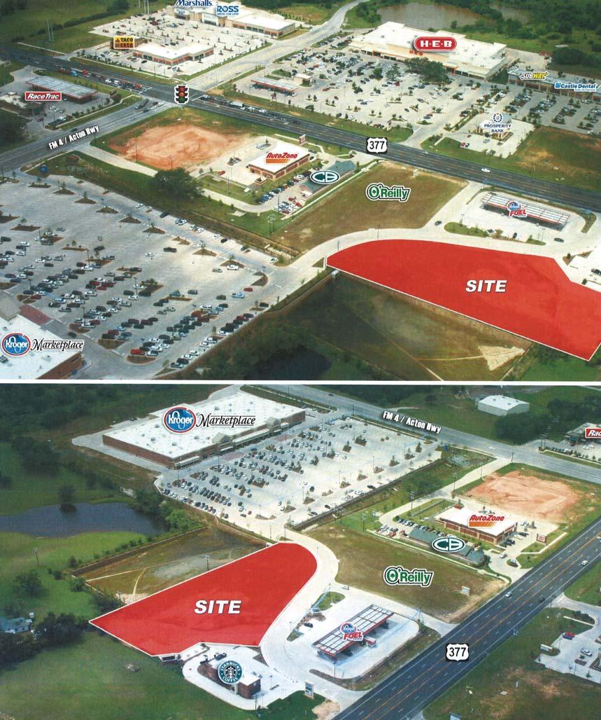
4 AERIAL
5 SURVEY CURVE RADIUS ARC LENGTH CHORD LENGTH CHORD BEARING C ' ' ' N 03 52'47" E C ' 30.25' 30.17' N 31 28'23" E C ' 83.93' 83.86' S 67 21'48" E C ' 29.78' 28.89' N 84 03'51" E 10' GAS EASEMENT(PLAT) C2 SET "X" 30' C3 30' FIRELANE & ACCESS EASEMENT(PLAT) LOT 2A-1, BLOCK 1 SLIDE P-503 C4 CONC. (TYP.) N 59 28'31" E 79.39' FND. 1/2" IRON ROD CAPPED SANITARY SEWER & DRAINAGE S 30 25'34" E ' V. 1449, P. 81 O.R.H.C.T. C1 LOT 1A, BLOCK 1 (30' FIRELANE, ACCESS & UTILITY EASEMENT-PLAT) SLIDE P-486 SDMH LP UTILITY EASEMENT(PLAT) N 38 30'20" E ' UTILITY EASEMENT(PLAT) OVERHEAD UTILITY(TYP.) SDMH LOT 2A-2, BLOCK 1 SLIDE P ACRES SSMH IN CONC. PP(TYP.) S 59 52'39" W ' LOT 1A, BLOCK 1 SLIDE P ' UTILITY EASEMENT(PLAT)(V. 1663, P. 336) 15' DRAINAGE EASEMENT(PLAT) SEWER EASEMENT(PLAT) EASEMENT(PLAT) FND. 1/2" IRON ROD CAPPED SSMH GUY(TYP.) SSMH IN CONC. FND. 5/8" IRON ROD CAPPED V. 1558, P. 873 O.R.H.C.T. S 59 53'17" W 65.43' SURVEY WITH IMPROVEMENTS BEING LOT 2A-2, BLOCK 1,, AN TO THE CITY OF GRANBURY, HOOD COUNTY, TEXAS. ACCORDING TO THE REPLAT AS RECORDED IN SLIDE P-503, PLAT RECORDS, HOOD COUNTY, TEXAS. I, THE UNDERSIGNED, A REGISTERED PROFESSIONAL LAND SURVEYOR IN THE STATE OF TEXAS, DO CERTIFY THAT THE ABOVE DESCRIBED PROPERTY WAS SURVEYED ON THE GROUND; BY ME OR UNDER MY DIRECT SUPERVISION; VISIBLE CONFLICTS, ENCROACHMENTS, AND OVERLAPS ARE AS SHOWN ON THIS PLAT OR MAP ATTACHED HERETO; THE AREA & BOUNDARY WERE DETERMINED WITH RESPECT TO THE RECORDED REFERENCES AS SHOWN; AND THE INFORMATION PRESENTED IS TRUE & CORRECT TO THE BEST OF MY KNOWLEDGE. IN, IT IS NOT INTENDED TO EXPRESS OR IMPLY WARRANTY, GUARANTEE OF OWNERSHIP, OR TRANSFER OF TITLE, AND THIS SURVEY IS SUBJECT TO ALL APPLICABLE COPYRIGHT LAWS FROM THE DATE OF THIS SURVEY. TO PROTECT ALL PARTIES INVOLVED, THIS SURVEY IS ONLY VALID IF ORIGINAL SEAL & SIGNATURE APPEAR ON THE FACE OF THIS SURVEY IN BLUE INK. KYLE RUCKER, REGISTERED PROFESSIONAL LAND SURVEYOR NO TEXAS SURVEYING, INC. - WEATHERFORD BRANCH 110 PALO PINTO STREET, WEATHERFORD, TEXAS WEATHERFORD@TXSURVEYING.COM DATE: NOVEMBER 24, JN SURVEY WITH IMPROVEMENTS 1) WITH RESPECT TO THE DOCUMENTS LISTED IN TITLE COMMITMENT NO RTT THE FOLLOWING EASEMENTS AND/OR RESTRICTIONS WERE REVIEWED FOR THIS SURVEY: SUBJECT TO THE RESTRICTIONS RECORDED IN: DOC.# ; OFFICIAL PUBLIC RECORDS, HOOD COUNTY, TEXAS. THE FOLLOWING EASEMENT(S) AND/OR DOCUMENT(S) DO(ES) AFFECT THIS TRACT: V. 1663, P. 336(SHOWN); REAL PROPERTY RECORDS, HOOD COUNTY, TEXAS. KYLE RUCKER 6444 ACCORDING TO EASEMENT DESCRIPTIONS, VISIBLY APPARENT LOCATION OF UTILITIES IN THE FIELD, PLAT/MAPS OF RECORD, TEXAS RAILROAD COMMISSION PUBLIC GIS VIEWER, TEXAS UTILITY LOCATION SERVICES (TEXAS811) AND THE SURVEYOR'S PROFESSIONAL OPINION. 2) OFFICIAL F.E.M.A. FLOOD HAZARD INFORMATION HAS NOT BEEN REVIEWED DURING THE COURSE OF THIS SURVEY, FOR UP TO DATE FLOOD HAZARD INFORMATION ALWAYS VISIT THE OFFICIAL F.E.M.A. WEBSITE AT ( 3) BEARINGS, DISTANCES, AND/OR AREAS DERIVED FROM GNSS OBSERVATIONS AND REFLECT N.A.D. 1983, TEXAS STATE PLANE COORDINATE SYSTEM, NORTH CENTRAL ZONE (GRID) 4) UNDERGROUND UTILITIES WERE NOT LOCATED DURING THIS SURVEY. CALL 811 AND/OR UTILITY PROVIDERS BEFORE EXCAVATION OR CONSTRUCTION. 5) PLEASE CONSULT ALL APPLICABLE GOVERNING ENTITIES REGARDING RULES & REGULATIONS, THAT MAY AFFECT CONSTRUCTION ON THIS PROPERTY. RL TEXAS SURVEYINGINC. Firm No
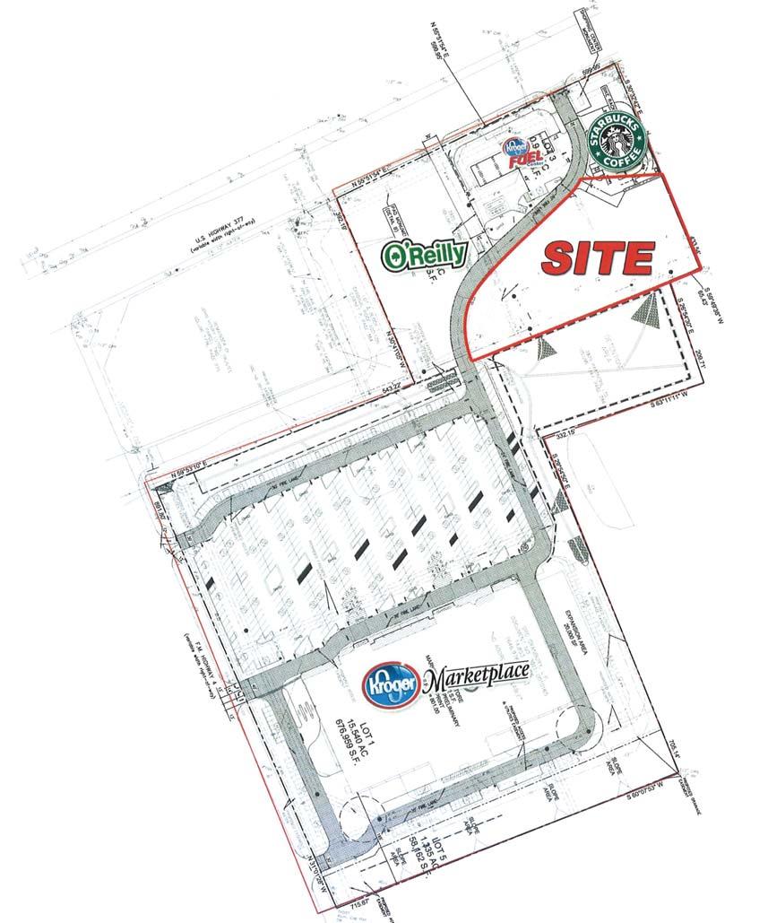
6 SITE PLAN

7
RULES OF THE GEORGIA STATE BOARD OF REGISTRATION FOR PROFESSIONAL ENGINEERS AND LAND SURVEYORS CHAPTER APPLICATIONS TABLE OF CONTENTS
 RULES OF THE GEORGIA STATE BOARD OF REGISTRATION FOR PROFESSIONAL ENGINEERS AND LAND SURVEYORS CHAPTER 180-7 APPLICATIONS TABLE OF CONTENTS 180-7-.07 Maps and Plats. All maps, plats and similar documents
DAWSON COUNTY MINOR PLAT REVIEW CHECKLIST $50.00 FEE PER PLAT REVIEW, $5.00 FEE FOR SCAN & CD FOR RECORDING
 DAWSON COUNTY MINOR PLAT REVIEW CHECKLIST $50.00 FEE PER PLAT REVIEW, $5.00 FEE FOR SCAN & CD FOR RECORDING NAME ON PLAT: CONTACT/PHONE #: NAMED STREET/ADDRESS: LAND LOT: DISTRICT: SECTION: ZONING: SETBACKS:
DALLAS WATER UTILITIES WATER/WASTEWATER COVENANT
 DALLAS WATER UTILITIES WATER/WASTEWATER COVENANT Procedure for obtaining a water and wastewater covenant, water covenant, or wastewater covenant; Required for initial submittal: 1. One letter from the
Department of Development Services Engineering; Survey Plat Review Group SPRG
 Department of Development Services Engineering; Survey Plat Review Group SPRG CITY OF DALLAS LEGAL DESCRIPTION PREPARATION GUIDELINE AND CHECKLIST The following guideline and checklist are provided to
CERTIFIED SURVEY MAP
 SCONSIN STATE PLANE N:389676.12 E:2130390.15 Center of Section 23 CERTIFIED SURVEY MAP 734.06' THE (PRITCHETTE) ORIGINAL PLAT OF ALL IN THE NW 1 4 OF THE SE 1 4 OF FRACTIONAL SECTION 23, T7N, R9E, IN THE
WASTEWATER BACKFLOW RELEASE PROCEDURES
 WASTEWATER BACKFLOW RELEASE PROCEDURES PROCEDURE FOR OBTAINING A WASTEWATER RELEASE FOR PRIVATE DEVELOPMENT PROJECTS: PLEASE NOTE THAT THE WASTEWATER BACKFLOW RELEASE DOCUMENT MUST FOLLOW THE CITY S PROCEDURES.
Group Sewer Only** 80 Ft Frontage* 20,000 Sq. Ft. (.46 acre) Minimum** 120 Ft Frontage* 20,000 Sq. Ft. (.46acre) Minimum** 150 Ft Frontage*
 Minimum** 120 Ft Frontage* 20,000 Sq. Ft. (.46acre) Minimum** 150 Ft Frontage*") Residential Lots Minimum Chart The minimum lot size of any minor subdivision where there is no public sewers shall be as shown below or as required by township zoning and/or the Tuscarawas General Health
Residential Lots Minimum Chart The minimum lot size of any minor subdivision where there is no public sewers shall be as shown below or as required by township zoning and/or the Tuscarawas General Health
Synergy Park Addition (Companion to item 3)
") Synergy Park Addition (Companion to item 3) Attachments: 1. Locator 2. Replat staff report 3. Replat W P G r es rg eo e s Bu hh wy Lot 6A 4.02-acres Lot 4C 13.02-acres Fran k Lots 4C and 6A, Block A Synergy
Synergy Park Addition (Companion to item 3) Attachments: 1. Locator 2. Replat staff report 3. Replat W P G r es rg eo e s Bu hh wy Lot 6A 4.02-acres Lot 4C 13.02-acres Fran k Lots 4C and 6A, Block A Synergy
Subdivision Plat Signature Block Templates
 Subdivision Plat Signature Block Templates Please refer to the Subdivision Plat Checklist to determine which signature blocks are required for the plat you are preparing. All text must be at least 10 pt
Palm Ave Hialeah Building Data Palm Avenue
 400-450 Palm Ave Hialeah Building Data Address 400-450 Palm Avenue City, State Hialeah, Florida County Miami Dade parcel # 04-3118-001-1950 and 1960 Zoning Retail Commercial - BU2 Land Size 13500 Type
Honorable Mayor Bill Agan and members of the Richland Hills City Council. Final Plat Richland Hills, Lots 1 & 2, Block 1 Brumlow Addition
 2B - 1 Memorandum To: From: Date: Subject: Honorable Mayor Bill Agan and members of the Richland Hills City Council Jason Moore, Assistant City Manager January 17, 2017 Final Plat Richland Hills, Lots
COMMERCIAL DEVELOPMENT OPPORTUNITY US HIGHWAY 281 NORTH AT FM 1863 BULVERDE, TEXAS
 COMMERCIAL DEVELOPMENT OPPORTUNITY US HIGHWAY 281 NORTH AT FM 1863 BULVERDE, TEXAS LOCATION: The property is located on the west side of U.S. Highway 281, just west of the intersection of FM 1863. ZONING:
Subdivision Plat Signature Block Templates
 Subdivision Plat Signature Block Templates Please refer to the Subdivision Plat Checklist to determine which signature blocks are required for the plat you are preparing. All text must be at least 10 pt
Avg. HH Income th Avenue Fort Worth, TX
 Site Available Southwest Corner of Old Decatur Road & W.J. Boaz Road PROPERTY SPECIFICATIONS: LOCATION: LAND SIZE: Southwest corner of Old Decatur Road & W.J. Boaz Road Approximately 1.46 Acres SITE ZONED:
2213 BUTLER PAD SITE NEAR NEW PARKLAND HOSPITAL. Butler Street at Redfield Dallas, Texas EDGE REALTY PARTNERS
 PAD SITE NEAR NEW PARKLAND HOSPITAL 2213 BUTLER Butler Street at Redfield Dallas, Texas EDGE REALTY PARTNERS 2213 BUTLER // Dallas, Texas LOCATION 2213 Butler Street Dallas, Texas 75235 SIZE 83,370 square
MINOR SUBDIVISION PLAT CHECKLIST
 MINOR SUBDIVISION PLAT CHECKLIST Project Name: Tax ID #: Project Number: Date: _ Reviewed By: Telephone: NOTES: All lots on septic systems must comply with the Fulton County Health Department requirements
FINAL PLAT. Community Development Department 8101 Ralston Road Arvada, Colorado 80002
 FINAL PLAT Community Development Department 8101 Ralston Road Arvada, Colorado 80002 September 2015 FINAL SUBDIVISION PLAT Final Subdivision Plat Review Applications for a Final Plat shall be submitted
a required for construction and of easement State to Highway Loop 12/Walton Walker Boulevard, require the conveyance 296,757 square feet
 WHEREAS, determined that to construct development and is necessary; WHEREAS, said for Creek and TxDOT eement COUNCIL CHAMBER 160642 April 27, 2016 City of Dall owns land known Elm Fork Greenbelt and TxDOT
MINOR SUBDIVISION PLAT
 MINOR SUBDIVISION PLAT Community Development Department 8101 Ralston Road Arvada, Colorado 80002 MINOR SUBDIVISION PLAT Subdivisions consisting of five (5) or fewer lots are eligible for the minor subdivision
MINOR SUBDIVISION PLAT
 MINOR SUBDIVISION PLAT Community Development Department 8101 Ralston Road Arvada, Colorado 80002 September 2015 MINOR SUBDIVISION PLAT Subdivisions consisting of five (5) or fewer lots are eligible for
DIVISION 2 - CONSTRUCTION PLAN AND MISCELLANEOUS REQUIREMENTS
 DIVISION 2 - CONSTRUCTION PLAN AND MISCELLANEOUS REQUIREMENTS 2.1 Required Plan Sheets 2.2 Drawing Requirements 2.3 Graphic Standards 2.4 Easements 2.5 Utility Locations 2.6 Private Facility Locations
AMENDING PLAT REQUIREMENTS Revised
 City of University Park AMENDING PLAT REQUIREMENTS Revised 9-3-2014 1. The amending plat is prepared with the appropriate certificates printed on the document and three (3) 24 x 36 paper copies are submitted
PRELMINARY PLAT CHECKLIST
 PRELMINARY PLAT CHECKLIST A. All preliminary plat submitted for approval shall be prepared by a Registered Professional Land Surveyor. B. Preliminary plats must be drawn to a scale of XXX with such accuracy
Preliminary Plat/Final Plat Application
 Melissa Municipal Center 3411 Barker Avenue Melissa, Texas 75454 Phone: (972) 838-2036 Applicant: Date: Address: Phone: Contact: Fax: E-mail: Propose Addition Name: Acres: Existing Zoning: Propose Zoning:
Final Plat Mapping Requirements
 CURRENT PLANNING DIVISION 410 E. 5 th Street Loveland, CO 80537 970-962-2523 eplan-planning@cityofloveland.org cityofloveland.org/dc Final Plat Mapping Requirements All Final plats shall comply with the
LAND FOR SALE - ± ACRES
 LAND FOR SALE - ± 6.109 ACRES 14248 FM 2769 Leander, TX 78641 3 2 5 6 183 SITE LOOP 1 620 620 1 LOCATION: SIZE: FRONTAGE/ ACCESS: UTILITIES: ZONING: TOPOGRAPHY: Approximately 4.7 miles west of FM 620 and
FINAL PLAT APPLICATION
 FINAL PLAT APPLICATION (Page 1 of 3) LEGAL OWNER(s): NAME: STREET ADDRESS OWNER(s): CITY, STATE, ZIP CODE: PHONE NUMBER: BILLING ADDRESS: NAME OF ENGINEER/SURVEYOR: Engineer/Surveyor Address, Phone: PROPERTY
LOCATION MAP: AERIAL PHOTOGRAPH, 2015:
 LOCATION MAP: AERIAL PHOTOGRAPH, 2015: ORDINANCE NO. AN ORDINANCE OF THE CITY OF BRYAN, TEXAS, AMENDING CHAPTER 130, ZONING, OF THE CITY OF BRYAN CODE OF ORDINANCES, BY CHANGING THE ZONING CLASSIFICATION
of Professional Surveyors
 Mississippi Association of Professional Surveyors Standards of Practice for Surveying in the State of Mississippi Exam Answer all questions. Sign and date the statement on last page. Send completed exam
APPLICATION FOR FINAL PLAT APPROVAL (Major Subdivision)
") APPLICATION FOR FINAL PLAT APPROVAL (Major Subdivision) CITY OF HOSCHTON, GA PLANNING AND DEVELOPMENT 79 City Square Hoschton, GA 30548 706-654-3034 Applicant Information: Name: Address: City, State, Zip:
APPLICATION FOR FINAL PLAT APPROVAL (Major Subdivision) CITY OF HOSCHTON, GA PLANNING AND DEVELOPMENT 79 City Square Hoschton, GA 30548 706-654-3034 Applicant Information: Name: Address: City, State, Zip:
APPLICATION FOR FINAL PLAT APPROVAL
 APPLICATION FOR FINAL PLAT APPROVAL Section 1. General. The undersigned Applicant (Applicant is synonymous with owner) makes this Application for Final Plat Approval in accordance with Chapter 21, Port
FINAL PLAT CHECKLIST
 FINAL PLAT CHECKLIST Project Name: Tax ID #: Project Number: Date: _ Reviewed By: Telephone: Please address all items marked with an "X" Please return redline comments with corrected plan, original mylar,
Oakland County Michigan Register of Deeds Plat Engineering, GIS, & Remonumentation Dept. Ph: (248) Fax (248)
 Fax (248)") Oakland County Michigan Register of Deeds Plat Engineering, GIS, & Remonumentation Dept. Ph: (248)-858-1447 Fax (248)-858-7466 Requirements Needed for Final Plat Approval No. General Requirements. 1 Routing
Oakland County Michigan Register of Deeds Plat Engineering, GIS, & Remonumentation Dept. Ph: (248)-858-1447 Fax (248)-858-7466 Requirements Needed for Final Plat Approval No. General Requirements. 1 Routing
CITY OF FAYETTEVILLE, ARKANSAS PROPERTY LINE ADJUSTMENT
 CITY OF FAYETTEVILLE, ARKANSAS PROPERTY LINE ADJUSTMENT FOR STAFF USE ONLY FEE: $200.00 Date Application Submitted: Date Accepted as Complete: S-T-R: Project Number: PP#: Public Hearing Zone: Please fill
AMENDING PLAT REQUIREMENTS Revised
 City of University Park AMENDING PLAT REQUIREMENTS Revised 10-2016 1. The amending plat is prepared with the appropriate certificates printed on the document and three (3) 24 x 36 paper copies are submitted
Rule 21 STANDARDS OF PRACTICE FOR SURVEYING
 Rule 21 STANDARDS OF PRACTICE FOR SURVEYING 21.1 Whenever a survey is performed, it shall comply with Section 73-13-71 (4) and Section 73-13- 73 and the Standards of Practice for Surveying in Mississippi
Submittal Requirements: Subdivision Plat (Final)
") s Planning and Zoning Submittal Requirements: Subdivision Plat (Final) 1. Application form, APO fees, and filing fee. Transportation Development Review Fee please contact Engineering at (970) 221-6605
s Planning and Zoning Submittal Requirements: Subdivision Plat (Final) 1. Application form, APO fees, and filing fee. Transportation Development Review Fee please contact Engineering at (970) 221-6605
City of Prior Lake APPLICATION FOR REGISTERED LAND SURVEY
 Case File No. Property Identification No. City of Prior Lake APPLICATION FOR REGISTERED LAND SURVEY Requested Action Brief description of proposed project (Please describe the proposed amendment, project,
Plats and subdivisions; mapping requirements. (a) Size Requirements. All land plats presented to the register of deeds for recording in the
 Size Requirements. All land plats presented to the register of deeds for recording in the") 47-30. Plats and subdivisions; mapping requirements. (a) Size Requirements. All land plats presented to the register of deeds for recording in the registry of a county in North Carolina after September
47-30. Plats and subdivisions; mapping requirements. (a) Size Requirements. All land plats presented to the register of deeds for recording in the registry of a county in North Carolina after September
COUNTY OF ADAMS, STATE OF COLORADO E. 40TH AVE. TOWER RD. E. 38TH AVE. SALIDA ST. HIGH LINE CANAL PROJECT LOCATION E. 32ND PKWY.
 LEGAL DESCRIPTION:, GATEWAY EAST AT TOWER SUBDIVISION FILING NO. 1, SAID PARCEL CONTAIN 598,154 SQUARE FEET OR MORE OR LESS GENERAL NOTES: 1. NOTICE: ACCORDING TO COLORADO LAW YOU MUST COMMENCE ANY LEGAL
LOCATION MAP SHEET 1 OF 10
 OWNER: ADDRESS: LOCATION MAP CENTURY LAND HOLDINGS II, LLC 6500 RIVER PLACE BLVD. BUILDING 2, SUITE 200 AUSTIN, TX 78730 OWNER: CITY OF LEANDER ADDRESS: P.O. BOX 319 LEANDER, TX 78646 ACREAGE: LOTS ACREAGE:
Application For Development Review (Subdivisions and Site Plan Review)
") Application For Development Review (Subdivisions and Site Plan Review) Thank you for your interest in Pickens County, South Carolina. This packet includes the necessary documents for review of subdivision
Application For Development Review (Subdivisions and Site Plan Review) Thank you for your interest in Pickens County, South Carolina. This packet includes the necessary documents for review of subdivision
Final Plat Approval of a Minor Subdivision Application Packet
 Final Plat Approval of a Minor Subdivision Application Packet 1. Application Packet. Be sure to complete and submit all the required materials that are a part of this Application Packet. Failure to do
CHECK LIST FOR REVIEW OF SURVEY PLATS FOR COMPLIANCE WITH MISSOURI MINIMUM STANDARDS FOR PROPERTY BOUNDARY SURVEYS NAME OF SURVEYOR: DATE OF SURVEY:
 CHECK LIST FOR REVIEW OF SURVEY PLATS FOR COMPLIANCE WITH MISSOURI MINIMUM STANDARDS FOR PROPERTY BOUNDARY SURVEYS NAME OF SURVEYOR: DATE OF SURVEY: REVIEWED BY: DATE: DESCRIPTION OF SURVEY: GENERAL LAND
PRELIMINARY PLAT CHECK LIST
 PRELIMINARY PLAT CHECK LIST Name of Proposed Subdivision: The following items must be included with the initial submittal of a Preliminary Plat: Application, filled out completely Project Narrative Pre-application
Final Plat Approval of a Major Subdivision Application Packet
 Final Plat Approval of a Major Subdivision Application Packet 1. Application Packet. Be sure to complete and submit all the required materials that are a part of this Application Packet. Failure to do
Easements, Establishments, Abandonments and Vacations
 Easements, Establishments, Abandonments and Vacations A highway easement conveys, in perpetuity, the right to construct and maintain a highway facility on the land of the fee holder. (Property owner) The
Grand Forks Growth Fund, A Jobs Development Authority Staff Report
 Grand Forks Growth Fund, A Jobs Development Authority Staff Report Growth Fund Committee March 20, 2017 JDA March 20, 2017 Agenda Item: Business Park Infrastructure Submitted by: Ryan Brooks, Deputy City
LOOP 410 / HIGHWAY 151 AREA DEVELOPMENT PROPERTY
 LOOP 410 / HIGHWAY 151 AREA DEVELOPMENT PROPERTY LOCATION: SIZE: FRONTAGE: The tract is located at the southwest corner of Loop 410 and Lakeside Parkway in the southwest quadrant of Loop 410 / Highway
FOR SALE ACRES UNDEVELOPED COMMERCIAL LAND DURHAM LAKES, CITY OF FAIRBURN, FULTON COUNTY, GA
 FOR SALE - 7.23 ACRES UNDEVELOPED COMMERCIAL LAND DURHAM LAKES, CITY OF FAIRBURN, FULTON COUNTY, GA COMMENTS This bank owned opportunity 7.23 acres of undeveloped commercial land located within the city
SECTION 6 - APPROVAL OF PLATS. Whenever any subdivision of land is proposed, and before any permit for the
 SECTION 6 - APPROVAL OF PLATS 6-1 APPROVAL REQUIRED BEFORE SALE Whenever any subdivision of land is proposed, and before any permit for the erection of a structure shall be granted, the subdivider or his
SECTION SITE SURVEYS
 PART 1 - GENERAL 1.1 DESCRIPTION SECTION 02 21 00 SPEC WRITER NOTES: 1. Use this section only for NCA projects. 2. Delete between //---// if not applicable to project. Also delete any other item or paragraph
Ballard City Final Plat Check List
 Ballard City Final Plat Check List TO BE COMPLETED BY BOTH THE DEVELOPER AND THE CITY Design: Check: Check each of the following items for compliance with adopted City Standards, Titles, General Plans
STANDARDIZED LEGAL DESCRIPTIONS AND EXHIBITS
 STANDARDIZED LEGAL DESCRIPTIONS AND EXHIBITS Public Works Department, Engineering Division June 14, 2004 UNIFIED GOVERNMENT STANDARDIZED LEGAL DESCRIPTIONS AND EXHIBITS For: Roads, Bridges, Short Span
ORDINANCE NO. BE IT ORDAINED BY THE CITY COUNCIL OF THE CITY OF DALLAS:
 ORDINANCE NO. * -1% L I An ordinance providing for the abandonment and relinquishment of a portion of a sanitary sewer easement located in City Block 1/818 in the City of Dallas and County of Dallas, Texas;
CITY OF PORT ST LUCIE
 CITY OF PORT ST LUCIE COUNCIL AGENDA MEMORANDUM Agenda Item #: 11B Meeting Date: 5/22/17 TO: Mayor and City 1Council 2 VIA: Russ Blackburrit, ity Manager Patricia Roeblirg, P.E., Assistant City Manager
Easements, Establishments, Abandonments and Vacations
 Easements, Establishments, Abandonments and Vacations Highway Easements: Where there is a right to construct and maintain a highway facility SH - Standard Highway easement LA - Limited Access Easement
REPLAT REQUIREMENTS Revised
 City of University Park REPLAT REQUIREMENTS Revised 02-2016 1. The replat is prepared with the appropriate certificates printed on the document and three (3) 24 x 36 paper copies are submitted with a completed
The Filing Fee for a Minor Plat is $ PLUS $20.00 per lot created
 DEPARTMENT OF COMMUNITY DEVELOPMENT MINOR PLAT PROCEDURE The Filing Fee for a Minor Plat is $250.00 PLUS $20.00 per lot created Description: The purpose of a Minor Plat is to allow property to be platted
Minor Subdivision Application
 FOR PLANNING USE ONLY Application # SD Application Fee $1,000.00 Receipt No. Filing Date Completeness Date Minor Subdivision Application A. PROJECT INFORMATION 1. Project Name: 2. Address of Subject Property:
ARTICLE XVI SUBDIVISION DEVELOPMENT
 ARTICLE XVI SUBDIVISION DEVELOPMENT 16.0 The division of land into 4 or more lots that will require the construction or extension of public streets, water or sanitary sewerage (other than the direct connection
3.92 AC on North Earl Rudder Fwy
 3.92 AC on North Earl Rudder Fwy Commercial Land For Sale Sam Rayburn Middle School Property Highlights Exceptional visibility from North Earl Rudder Freeway Extremely high traffic counts Situated in high
INVITATION FOR PROPOSALS SALE OF REAL PROPERTY INSTRUCTIONS, TERMS AND CONDITIONS
 INVITATION FOR PROPOSALS SALE OF REAL PROPERTY INSTRUCTIONS, TERMS AND CONDITIONS The City Council of the City of Covington invites members of the general public to submit sealed bid proposals to purchase
Standards of Practice for Surveying in the State of Alabama
 Standards of Practice for Surveying in the State of Alabama Effective January 1, 2017 RULE NO. 1.01 PURPOSE The purpose of these rules is to establish standards for the practice of surveying in the State
Township of Collier 2418 Hilltop Road Presto, PA 15142
 Township of Collier 2418 Hilltop Road Presto, PA 15142 Fees: Major: 2 checks $600 + $50 per lot & $1700 Escrow) APPLICATION FOR SUBDIVISION major FINAL only Plans must be folded Rolled plans will not be
STRATEGIC COMMERCIAL TRACT WEST AVENUE AT WURZBACH PARKWAY SAN ANTONIO, TEXAS
 STRATEGIC COMMERCIAL TRACT WEST AVENUE AT WURZBACH PARKWAY SAN ANTONIO, TEXAS LOCATION: SIZE: FRONTAGE: The property is located at the southeast corner of West Avenue and Wurzbach Parkway about one half
Walton County Planning and Development Services
 Walton County Planning and Development Services 31 Coastal Centre Boulevard, Suite 100 47 N 6 th Street Santa Rosa Beach, Florida 32459 DeFuniak Springs, Florida 32433 Phone 850-267-1955 Phone 850-892-8157
APPLICATION FOR PRELIMINARY PLAT CERRO GORDO COUNTY, IOWA
 APPLICATION FOR PRELIMINARY PLAT CERRO GORDO COUNTY, IOWA Before subdividing any tract of land and previous to the filing of an Application for conditional approval of the Preliminary Plat, the subdivider
PLAT OF SURVEY VICINITY MAP (NOT TO SCALE) N N W E SITE BENCHMARK # 2 W E N&D ON BACK OF CURB NAVD 88 S S 0' 10' 20' 40' 60' 1" = 20' TOP=106.7
 N N W E SITE BENCHMARK # 2 W E N&D ON BACK OF CURB NAVD 88 S S 0' 10' 20' 40' 60' 1 = 20' TOP=106.7") PLAT OF SURVEY VICINITY MAP (NOT TO SCALE) N N W E SITE BENCHMARK # 2 W E N&D ON BACK OF CURB 106.21 NAVD 88 S S 0' 10' 20' 40' 60' 1" = 20' TOP=106.72 N INV PVC=99.27 S INV PVC=99.32 E INV CLAY=99.39
PLAT OF SURVEY VICINITY MAP (NOT TO SCALE) N N W E SITE BENCHMARK # 2 W E N&D ON BACK OF CURB 106.21 NAVD 88 S S 0' 10' 20' 40' 60' 1" = 20' TOP=106.72 N INV PVC=99.27 S INV PVC=99.32 E INV CLAY=99.39
Map Filing Law. 46: Effective date This act shall take effect January first, one thousand nine hundred and fiftyfour.
 46:23-9.8. Effective date This act shall take effect January first, one thousand nine hundred and fiftyfour. L.1953, c. 358, p. 1941, s. 8. 46:23-9.9. Short title This act shall be known and may be cited
géãç Éy VtÇtÇwt zât 5440 Routes 5 & 20 West Canandaigua, NY Phone: (585) / Fax: (585)
 / Fax: (585)") géãç Éy VtÇtÇwt zât 5440 Routes 5 & 20 West Canandaigua, NY 14424 Phone: (585) 394-1120 / Fax: (585) 394-9476 APPLICATION FOR LOT-LINE ADJUSTMENT The applicant is responsible for the completeness of all
géãç Éy VtÇtÇwt zât 5440 Routes 5 & 20 West Canandaigua, NY 14424 Phone: (585) 394-1120 / Fax: (585) 394-9476 APPLICATION FOR LOT-LINE ADJUSTMENT The applicant is responsible for the completeness of all
AGENDA ITEM: VIII-A DATE: 04/06/17 APPLICANT: AR Sanchez, Jr. ENGINEER: Crane Engineering REQUEST: Review and consideration of the Southern Developmen
 AGENDA ITEM: VIII-A DATE: 04/06/17 APPLICANT: AR Sanchez, Jr. ENGINEER: Crane Engineering REQUEST: Review and consideration of the Southern Development Subdivision Master Plan. The intent is residential
WILLIS PAD SITES SWQ of I-45 & FM 1097 Willis, TX 77378
 FOR LEASE SWQ of I-45 & FM 1097 Willis, TX 77378 PROPERTY INFORMATION Highly visible pad sites at signalized intersection along FM 1097 Directly across from new high-volume Kroger Marketplace Excellent
FENCE BUILDING PERMIT APPLICATION
 Village of Glen Ellyn Planning & Development Department 535 Duane Street Glen Ellyn, IL 60137 Phone: 630-547-5250; Fax: 630-547-5370 www.glenellyn.org FENCE BUILDING PERMIT APPLICATION Permit Number Date
SUBDIVISION APPLICATION
 SUBDIVISION APPLICATION Preliminary Plat Minor Plat Final Plat Amended Plat Applicant Name: Owner (if different from applicant) Name: Company: Company: Address: Address: City, State, Zip City, State, Zip
Kansas Minimum Standards For Boundary Surveys and Mortgagee Title Inspections Standards of Practice
 5/28/2010 9:28 PM 1 Kansas Minimum Standards For Boundary Surveys and Mortgagee Title Inspections Standards of Practice PREFACE These standards were first adopted by the Kansas Society of Land Surveyors
Administrative Plat Application Form
 1 Administrative Plat Application Form This form shall be submitted with each application for an administrative plat. CONTACT INFORMATION Applicant Architect (if different) Property Owner (if different)
APPENDIX C: PLAT SPECIFICATIONS AND CERTIFICATES
 APPENDIX C: PLAT SPECIFICATIONS AND CERTIFICATES A. Drawing. All plats for recording must be submitted on photographically reproducible and dimensionally stable polyester sheets such as Mylar, Cronar or
Dact= Bk:31661 Ps: 116
 Dact= 33591 Bk:31661 Ps: 116 AMENDMENT TO THE MASTER DECLARATION OF COVENANTS, CONDITIONS AND RESTRICTIONS FOR DUNSTAN CROSSING [Submission of Project Phase IIIl CHAMBERLAIN CONSTRUCTION, INC., a Maine
Change In The Name Of Owner (s) Of Land.
 Of Land.") Clermont County TRANSFER AND CONVEYANCE STANDARDS OF THE CLERMONT COUNTY AUDITOR AND THE CLERMONT COUNTY ENGINEER AS ADOPTED UNDER OHIO REVISED CODE SECTION 319.203, AS A RESULT OF TWO PUBLIC HEARINGS
Clermont County TRANSFER AND CONVEYANCE STANDARDS OF THE CLERMONT COUNTY AUDITOR AND THE CLERMONT COUNTY ENGINEER AS ADOPTED UNDER OHIO REVISED CODE SECTION 319.203, AS A RESULT OF TWO PUBLIC HEARINGS
BOSSIER CITY PARISH METROPOLITAN PLANNING COMMISSION 620 Benton Rd. Bossier City, LA Phone: Fax: PRELIMINARY PLAT
 (OFFICE USE ONLY) Application Fee: Paid: Date: CASE # Project Information BOSSIER CITY PARISH METROPOLITAN PLANNING COMMISSION 620 Benton Rd. Bossier City, LA 71111 Phone: 318-741-8824 Fax: 318-741-8827
City of Prior Lake APPLICATION FOR COMBINED PRELIMINARY AND FINAL PLAT
 Case File No. Property Identification No. City of Prior Lake APPLICATION FOR COMBINED PRELIMINARY AND FINAL PLAT Requested Action Brief description of proposed project (Please describe the proposed amendment,
PARCEL MAP CHECK ENG
 Engineering Division 201 North Broadway, Escondido, CA 92025 (760) 839-4651, FAX (760) 839-4597 PARCEL MAP CHECK ENG To: Date: Project: Site Address Check No. Attn: Via: The attached plans have been reviewed
City of Colleyville Community Development Department. Subdivision Application Packet
 Community Development Department Subdivision Application Packet 1 Development Application Fees 100 Main Street Colleyville TX 76034 817.503.1050 Zoning Zoning Change $ 500 + $5 per acre Planned Unit Development
CITY OF FAYETTEVILLE, ARKANSAS FINAL PLAT FOR STAFF USE ONLY FINAL PLAT FEE: $ $ Date Application Submitted: Date Accepted as Complete:
 CITY OF FAYETTEVILLE, ARKANSAS FINAL PLAT FOR STAFF USE ONLY FINAL PLAT FEE: $200.00-$800.00 Date Application Submitted: Date Accepted as Complete: Project Number: Public Hearing S-T-R: PP#: Zone: Please
CITY OF DECATUR, TEXAS
 Final Plat or Amending Plat / Replat Checklist A submittal of a complete application will facilitate a timely review. Failure of the applicant to provide required information or obtain a waiver from the
SUBDIVISION PLAT CHECKLIST. The following information shall be include on the plat:
 SUBDIVISION PLAT CHECKLIST Subdivision Name: Land Surveyor: Owner/Developer: Date Submitted: The following information shall be include on the plat: The plat shall be drawn at a scale of one inch equals
FINAL PLAN CHECKLIST
 FINAL PLAN CHECKLIST Subdivision Name: Subdivision Number: Project Number: REVIEW CRITERIA Plans: A final plan shall be on a 24 x 36 sheet at a scale that is no smaller than 1 = 40 and shall contain all
PROPERTY DESCRIPTION: Property is located in: City Limits County(Outside City Limits) Site Address/Location:
 Site Address/Location:") Application for Lot-Tract Split/Combo or Property Line Adjustment CITY OF CENTERTON PLANNING DEPARTMENT 290 N. MAIN ST., P.O. BOX 208 CENTERTON, AR 72719 PHONE (479)795-2750 FAX (479)795-2545 Planning@centertonar.us
Application for Lot-Tract Split/Combo or Property Line Adjustment CITY OF CENTERTON PLANNING DEPARTMENT 290 N. MAIN ST., P.O. BOX 208 CENTERTON, AR 72719 PHONE (479)795-2750 FAX (479)795-2545 Planning@centertonar.us
SUBDIVISION APPLICATION
 STAFF USE ONLY Date Submitted: Received by: Fee paid: Project # REQUIRED SUBMITTALS Application Fee: $600.00 (up to 5 lots) + $50.00 (per lot above 5) Publication Fee: $300.00 Mailing Fee: $6.00 per hearing
SUBDIVISION APPLICATION INSTRUCTIONS
 SUBDIVISION APPLICATION INSTRUCTIONS APPLICATION FORM The application form must be fully completed, signed by the property owner and shall be properly notarized. AGENT AUTHORIZATION FORM If the applicant
Memorandum September 13, 2018
 Memorandum September 13, 2018 TO: FROM: Planning and Zoning Commission Julie Couch, Town Manager Israel Roberts, AICP Planning Manager SUBJECT: FINAL PLAT FOR THE EBERSOHL ADDITION BACKGROUND: This is
CITY OF LEE S SUMMIT MINOR PLAT PROCESS. Purpose of Minor Plats
 MINOR PLAT PROCESS Purpose of Minor Plats The City of Lee s Summit requires that all property be platted before a building permit is issued. Platting involves the subdivision of land into lots or tracts.
NOT TO BE SUBMITTED WITH SKETCH DESIGN APPROVAL Subdivision Checklist: Major Subdivision Final Plat
 Must be received with review fee (equal to $200.00, plus $25.00 per lot) no later than 15 days prior to Planning Board meeting, which is normally the first Monday of the month (certain holidays may modify
City of Fort Lupton Amended Plat Process
 City of Fort Lupton Amended Plat Process Purpose The Amended Plat process is an administrative process to amend a recorded Plat. An Amended Subdivision is an administrative revision to a recorded Subdivision
COMMERCIAL PAD OPPORTUNITY SAN ANTONIO, TEXAS
 COMMERCIAL PAD OPPORTUNITY SAN ANTONIO, TEXAS LOCATION: SIZE: The site located on the west corner of Culebra Road and Lone Star Parkway. 0.595 Acres UTILITIES: Electric: City Public Service maps indicate
HARLINGEN IRRIGATION DISTRICT REQUIREMENTS FOR SUBDIVISION PLAT APPROVAL
 HARLINGEN IRRIGATION DISTRICT REQUIREMENTS FOR SUBDIVISION PLAT APPROVAL Administrative Requirements 1. All assessments and outstanding invoices associated with the property to be subdivided must be current.
SUBDIVISION APPLICATION: RECOMBINATION PLAT or EXEMPT PLAT
 SUBDIVISION APPLICATION: RECOMBINATION PLAT or EXEMPT PLAT Pursuant to Article 7, Section 155.706 of the Unified Development Code, an owner of land within the jurisdiction of the Town (or a duly authorized
SEARS BUILDING & LAND for SALE
 SALE LEASEBACK OPPORTUNITY/ REDEVELOPMENT POTENTIAL SEARS BUILDING & LAND for SALE 8235 Douglas Ave Suite 720 Dallas, Texas 75225 T 214.378.1212 venturedfw.com MALL OF ABILENE 4310 BUFFALO GAP RD ABILENE,
MINOR PLAT. The following documents are provided as required by the City of Conroe for use in the above titled platting submittals:
 Public Works - Engineering Division CITY OF CONROE MINOR PLAT The following documents are provided as required by the City of Conroe for use in the above titled platting submittals: Submittal Questionnaire