PLANNING COMMISSION STAFF REPORT
|
|
|
- Derick Floyd
- 5 years ago
- Views:
Transcription
535-7282 wayne.mills@slcgov.")
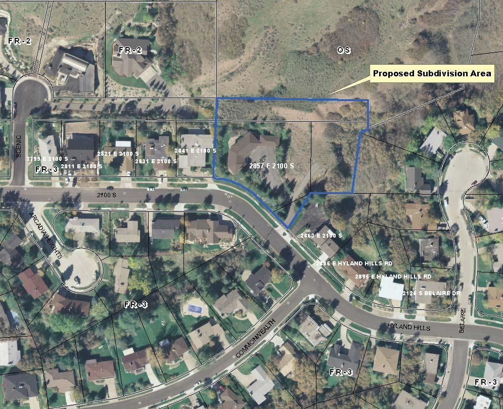
1 PLANNING COMMISSION STAFF REPORT Alder-Robinson Subdivision Amending the Amended Plat of the Arcadia Heights Plat A Subdivision Case #PLNSUB East 2100 South June 23, 2010 Applicant: Greg Robinson Planning and Zoning Division Department of Community Development Staff: Wayne Mills (801) wayne.mills@slcgov.com Tax ID: , , Zone: FR-3/12000 Foothills Residential District and OS Open Space District Master Plan Designation: Very Low-Density Residential Council District: 7, Council Member Søren Simonsen Acreage: 1.64 acres Use: Residential Applicable Land Use Regulations: 20.31, Article II (Subdivision Ordinance) 21A.24 (Zoning Ordinance) Request Greg Robinson is requesting an amendment to the Amended Plat of the Arcadia Heights Plat A Subdivision. The subdivision area consists of one existing buildable lot containing a single-family home and three nonbuildable parcels. The purpose of the subdivision is to combine and reconfigure the existing parcels to create two buildable lots. The proposed subdivision is located in the FR-3 Foothills Residential and OS Open Space zoning district. Staff Recommendation Staff recommends that the Planning Commission approve the Alder- Robinson Subdivision, an amendment to the Amended Plat of the Arcadia Heights Plat A subdivision, according to the findings and analysis in this staff report, and the following conditions of approval: 1. A final subdivision plat application is filed with the Planning Division and the final plat is recorded with the Salt Lake County Recorder; 2. Applicant must comply with all division requirements prior to recording the final plat; 3. The buildable area on Lot 1 is limited to 6,400 square feet; and 4. The buildable area on Lot 2 is limited to 5,356 square feet. Attachments: A. Proposed Plat B. Block Face Lot Size and Buildable Area Comparison C. Photos D. Department/Division Comments PLNSUB Alder-Robinson Subdivision Published Date: June 18,
, one triangular shaped lot that serves as driveway access to the single-family home")
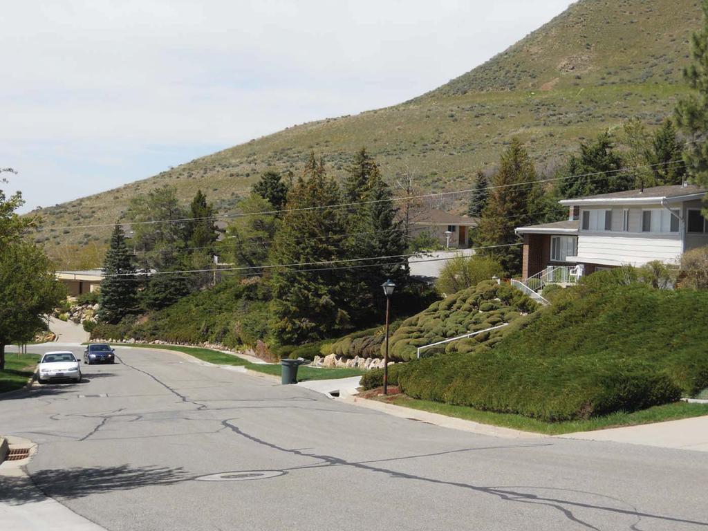
2 Vicinity Map Background The proposed subdivision is located at 2857 East 2100 South in the East Bench community planning area. The subdivision area consists of one existing buildable lot containing a single-family home (Lot B shown above), one triangular shaped lot that serves as driveway access to the single-family home (Lot D shown above), and two existing non-buildable parcels (Lots A and C shown above). These parcels are considered non-buildable because they do not have street frontage. The parcel containing the single-family dwelling (Lot B) and the triangular shaped lot (Lot D) are located in the Arcadia Heights Plat A Amended Subdivision. The two remaining parcels are not located in a platted subdivision. The applicant is requesting the proposed subdivision in order to add additional rear yard area to the lot containing the single-family dwelling. This would allow the applicants to add onto the home and meet rear yard setback requirements. The proposal would also create an additional buildable lot for a future single-family dwelling. PLNSUB Alder-Robinson Subdivision Published Date: June 18,
3 Property History Staff is unable to find a detailed history of why the parcels in the proposed subdivision are configured the way they are. Records have been found showing that the northern most rectangular lot (Lot A) was the continuation of a private right-of-way located to the west. Right-of-way access was closed off in 1992 with the annexation of the Scenic Circle subdivision located to the west of Lot A. Lot A was annexed into the City in 2002 as part of the Turville Annexation. Staff can find no records showing how the eastern most landlocked parcel (Lot C) was created. Both of these lots are considered non-buildable because they do not have frontage on a public street. The parcel containing the single-family dwelling was created as part of the Arcadia Heights Plat A Subdivision in In 1963, the property owner at the time was granted a variance to construct the single-family dwelling without the required rear yard setback. Subdivision Proposal The applicant is requesting subdivision approval to reconfigure the existing lots and create an additional buildable parcel (see proposed preliminary plat, Attachment A). The two proposed lots have the following dimensions: Lot Width Lot Size Lot feet 36,725 square feet (0.84 acres) Lot 2 92 feet 34,593 square feet (0.79 acres) The lots in the proposed subdivision would utilize the existing driveway access (located on proposed Lot 2) for both parcels. A cross access easement would need to be recorded on Lot 2 providing permanent driveway access to Lot 1. Zoning Review The proposed subdivision is located in the FR-3 Foothills Residential zoning district. The FR-3 minimum lot area standard is 12,000 square feet and the minimum lot width is 80 feet. The proposed subdivision meets the minimum lot area and lot width zoning regulations. In all Foothill Residential zoning districts there are slope restrictions on lots created after 1994 that prohibit building on significant steep slopes. A significant steep slope is defined as a slope that exceeds a 30% grade. The proposed preliminary plat identifies slopes over 30%. If the preliminary plat is approved, the final plat will need to identify these areas as non-buildable. In addition to minimum lot size standards, there are maximum lot size restrictions in all single-family zoning districts. In the FR-3 district, the maximum lot size is 18,000 square feet. The purpose of the regulation is to prohibit large lots with large buildable areas that would allow homes that are out of scale with the surrounding neighborhood. The code allows lots in excess of the maximum lot size limitation through the subdivision process if: 1. The size of the new lot is compatible with other lots on the same block face; 2. The configuration of the lot is compatible with other lots on the same block face; and 3. The relationship of the lot width to the lot depth is compatible with other lots on the same block face. PLNSUB Alder-Robinson Subdivision Published Date: June 18,
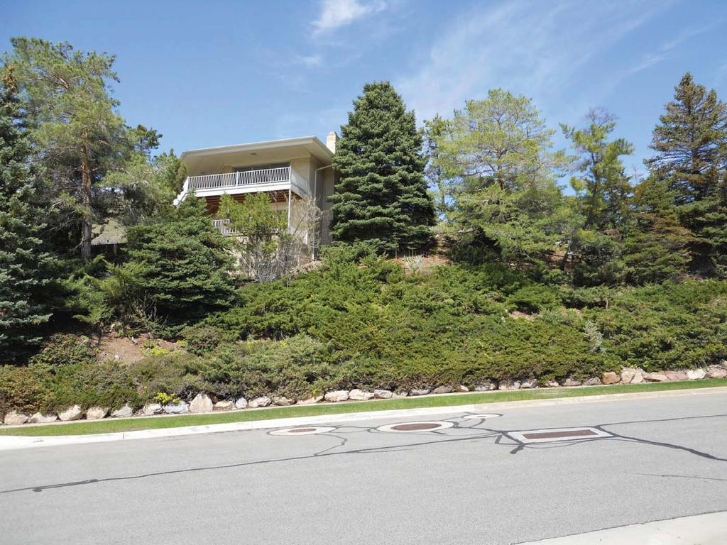
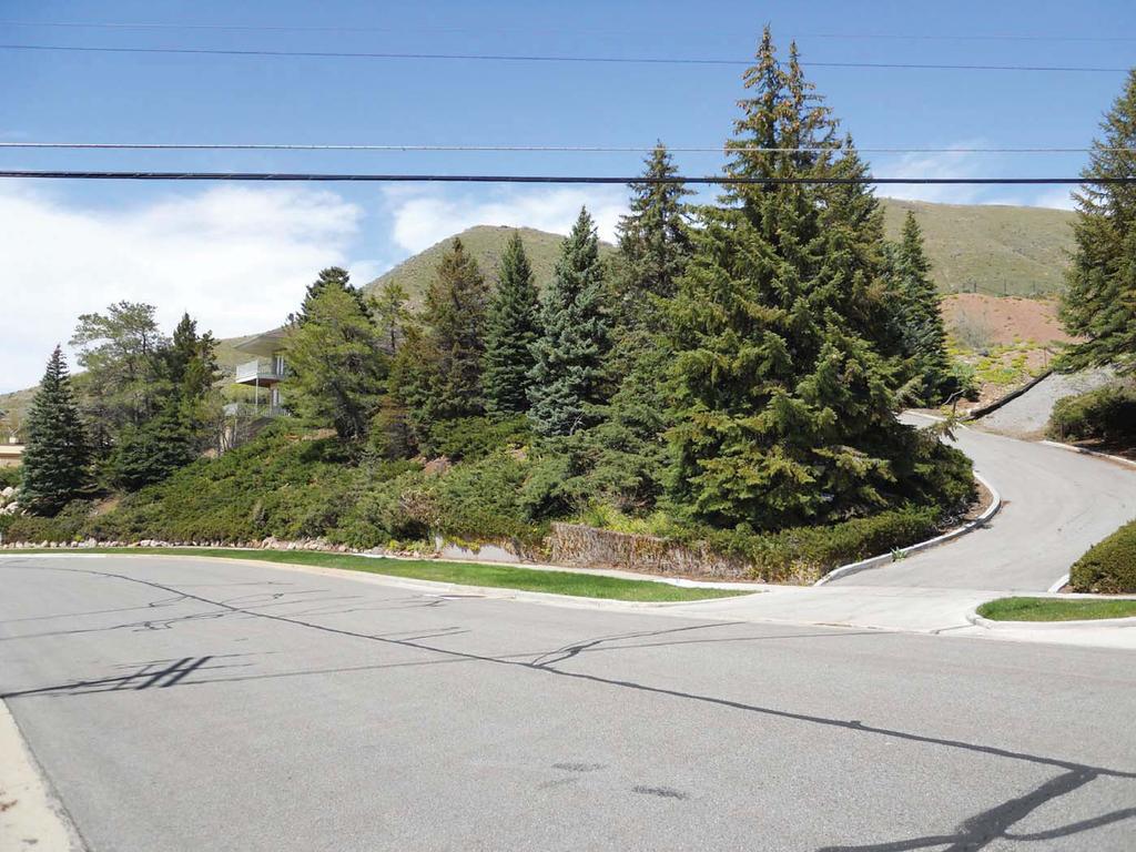
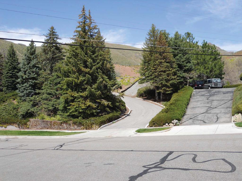
4 In this case, the block face is defined as the lots on the same side of the street as the proposed subdivision, between Scenic Circle and Lakeline Drive (see Vicinity Map for reference). Staff prepared a spreadsheet (see Attachment B) showing the sizes of the parcels along the block face and their potential building pads based on the 35% maximum lot coverage as allowed in the FR-3 zoning district. The block face lot sizes range from approximately 8,000 square feet to 18,500 square feet with an average of 11,471 square feet. The potential building footprints range in size from approximately 2,800 square feet to 6,500 square feet, with an average of 4,015 square feet. At 36,725 square feet and 34,593 square feet, both of the lots in the proposed subdivision exceed the 18,000 square foot maximum lot size limitation of the FR-3 district and exceed the sizes of all of the lots on the block face. However, the applicants have proposed a limit on the buildable areas of the two lots to meet the compatibility standards required to approve oversize lots. The proposed buildable areas are: Lot 1 = 6,400 square feet o The buildable area is not shown on the plat because the property owners would like design flexibility on an addition to the existing home. The buildable area limitation would need to be documented on the final plat. Lot 2 = 5,356 square feet o The buildable area is shown on the proposed preliminary plat. Any future structure built on the parcel would need to be contained within the buildable area. The proposed buildable areas do not exceed the largest potential building footprint on the block face; however, they do exceed the block face average (see Attachment B). There are mitigating factors that can be considered that would justify allowing larger buildable areas on the two proposed parcels. The mitigating factors are as follows: The orientation of the buildable areas is different than the other lots on the block face. The existing lots on the block face have a typical street frontage orientation in that the homes have a visible street presence. The average front yard setback of the existing homes along the block face is approximately 20 feet. The existing home in the proposed subdivision is oriented more to the side yard with little street presence and the buildable area on proposed Lot 2 is setback approximately 115 feet from the front property line. The topography of the two proposed lots and mature front yard landscaping prevents the majority of the buildable areas from being seen at the street level (see photos, Attachment C). It is important to note from a compatibility standpoint that the existing parcel containing the single-family dwelling (Lot B on the Vicinity Map) is approximately 36,155 square feet in size. Other than standard setback, building coverage, and height regulations, there are no other limitations on the size of the home that can be built on this parcel. At the allowable 35% building coverage, a home could be built with a building footprint of approximately 12,650 square feet, which is considerably larger than the potential block face building coverage average. Comments Public Comments No public comments were received at the time this staff report was written. PLNSUB Alder-Robinson Subdivision Published Date: June 18,
5 City Department Comments The proposed subdivision was reviewed by the applicable City departments and divisions. The review comments have been attached to this report as Exhibit D. Issues Only Public Hearing On May 26, 2010 the Planning Commission reviewed the proposed subdivision in an Issues Only Public Hearing. One individual spoke at the public hearing and asked if Scenic Circle would be used for access to any of the proposed lots. Staff responded stating that Scenic Circle would not be used for access. The lots would be accessed from an existing driveway located on 2100 South. The Planning Commission did not request additional information from Staff but asked the following questions: Can the Planning Commission consider an option to approve a combination of all of the lots into one parcel and then limit the buildable area? The result would be one lot, not two. o Staff Response: The Planning Commission could consider this option; however, the applicant is requesting two lots. The applicant would have to decide if he would like to carry through with a one lot subdivision with a limit on the buildable area or withdraw the subdivision request and build a larger home on his existing lot. Can the applicant request a variance from the rear yard setback to add on to the existing home without having to go through the subdivision process? Analysis o Staff Response: It is Staff s opinion that a variance could not be obtained because the addition would not meet the standards of approval for a variance. Master Plan Compliance The proposed subdivision is located within the East Bench Master Plan area. The Future Land Use Map in the Master Plan identifies the properties within the subdivision area as Very Low-Density Residential. The residential density of the proposed subdivision is consistent with the Very Low-Density Residential future land use classification. Subdivision Amendment Standards for Approval The proposed subdivision requires an amendment to the Amended Plat of the Arcadia Heights Plat A subdivision. A subdivision amendment petition may be approved only if it meets the requirements specified in Section of the Salt Lake City Code. The standards for approval are as follows: A. The amendment will be in the best interests of the city. Analysis: The proposed subdivision would add an additional building lot in a developed area of the City. When the lot is developed, it will increase the City s housing stock. Staff is of the opinion that this is in the best interest of the City. Furthermore, the subdivision would consolidate parcels that are privately owned, zoned for residential development, and are currently landlocked and unusable. Staff is of the opinion that cleaning up the current lot configuration is in the best interest of the City. PLNSUB Alder-Robinson Subdivision Published Date: June 18,
6 Finding: Staff finds that the proposed subdivision is in the best interests of the City. B. All lots comply with all applicable zoning standards. Analysis: The proposed lots meet the minimum dimensional zoning standards; however, they exceed the maximum lot size regulation. Lots that exceed the maximum lot size can be approved through the subdivision process. The maximum lot size issue is addressed in the Background section of this Staff Report. Finding: Staff finds that the proposed lots comply with applicable zoning standards only if the buildable areas of the proposed lots are limited to the sizes proposed by the applicant. C. All necessary and required dedications are made. Analysis: The preliminary plat shows a five foot public utility easement running through the building pad on Lot 2. According to a title report submitted by the applicant, there are no utilities currently located within this easement. The applicant will need to work with the City Department of Public Utilities and other local utility companies to either relocate or abandon the easement. This would be a condition of final plat approval. Finding: This is a condition of final plat approval. D. Provisions for the construction of any required public improvements are included. Analysis: Comments from the Engineering Division indicate that the existing sidewalk, curb and gutter need repair. These issues will need to be resolved prior to the approval of the final plat. Finding: This is a condition of final plat approval. E. The amendment complies with all applicable laws and regulations. Analysis: The Transportation Division has expressed concern with the driveway access to Lot 2. The concern relates to the steepness of the driveway grade (see Department/Division Comments, Attachment D). The applicant will need to provide documentation to the City that the building pad for Lot 2 can be accessed according to the City s driveway standards as a condition of final plat approval. Finding: The applicant will be required to comply with Transportation Division requirements as a condition of final plat approval. F. The amendment does not materially injure the public or any person and there is good cause for the amendment. Analysis: Staff can find no evidence that the proposed subdivision would materially injure the public or any person. Furthermore, there is good cause for the amendment in that it would consolidate noncomplying landlocked parcels Finding: Staff finds that the amendment would not materially injure the public or any person and there is good cause for the amendment. PLNSUB Alder-Robinson Subdivision Published Date: June 18,
7 EXHIBIT A Preliminary Plat PLNSUB Alder-Robinson Subdivision Published Date: June 18,
8 LOT 6 LOT 4 SCENIC CIRCLE SUB PARCEL 4A (RIGHT OF WAY) DOMED BRASS CAP WITH X IN HANDHOLE BASIS OF BEARINGS N 30 03'32" E ' N 89 41'10" W PLAT MEAS S 89 41'10" E 30% GRADE LANDSCAPING S 62 41'21" W 95.98' LOT 13 TURVILLE OVERHEAD POWER LINES E E E E E E E E E N 02 54'30" E ' LOT =04 30'00" R=166.00' L=13.04' FND RIVET IN WALK ON PROP LINE 1.81' TO CORNER DOMED BRASS CAP WITH X IN HANDHOLE 30% GRADE, LANDSCAPING sq ft D=40 11'10" R=166.00' L= ' LOT 1 36,725 S.F 0.84 ACRES 20' WIDE DRAINAGE EASEMENT 2100 SOUTH STREET 33.00' 33.00' N 00 18'50" E P POLE ALDER-ROBINSON SUBDIVISION AMENDING LOTS 8,9 AND 10 OF THE AMENDED PLAT OF ARCADIA HEIGHTS PLAT A SUBDIVISION SET X ON CONC FENCE FOOTING ' 50.00' EASEMENT OVER POWER LINES, UP&L SET REBAR & CAP LOCATED IN THE SW 1/4 OF SECTION 14, AND THE NW 1/4 OF SECTION 23, TOWNSHIP 1 SO., RANGE 1 EAST, SLB& M ' sq ft 5' PUBLIC UTIL EASEMENT S 07 00'00" W sq ft E E E E E E E E E E E LOT 2 34,593 SF 0.79 ACRES P POLE 30% GRADE, UNBUILDABLE AREA sq ft 20.23' S 66 30'00" W OVERHEAD POWER LINES 5' PUBLIC UTIL EASEMENT PROPOSED BUILDING PAD 5356 S.F. FND STEEL PIPE FND STEEL PIPE N 89 41'10" W 12.00' 80.00' N 45 00'00" W 92.00' 33.00' 33.00' ARCADIA HEIGHTS PLAT C S 32 09'50" W 93.78' AN EASEMENT EXISTS OVER THAT PORTION OF THE CROCKER DRIVEWAY THAT ENCROACHES SET REBAR & CAP 5' PUBLIC UTIL EASEMENT 92.67' ' P POLE SET REBAR & CAP S 00 18'50" W 64.77' LOT TURVILLE LOT ARCADIA HEIGHTS PLAT D ' LOT 301 NORTH GRAPHIC SCALE 30 FEET 60 LOT 12 SET RIVET IN WALK ON PROP LINE 3.00' TO CORNER LOT ' LOT 32 ADDRESSES LOT ' LOT EAST 2100 SOUTH STREET LOT EAST 2100 SOUTH STREET LOT 304 FIRE HYDRANT COMMONWEALTH AVE LEGEND SECTION, QUARTER SECTION, STREET OR OTHER SURVEY MONUMENT BOUNDARY OR PROPERTY LINE, WITH CORNER RIGHT OF WAY LINE, ADJOINING PROPERTY LINES CURTIS & ASSOCIATES, INC. CENTERLINE FENCE LINE LAND SURVEYING PLANNING FIRE HYDRANT 9480 SO. UNION SQUARE, STE 204 AREA OF 30% GRADE SANDY, UTAH (801) NUMBER ACCOUNT SHEET OF SHEETS HEALTH DEPARTMENT APPROVED THIS DAY OF, A.D DIRECTOR, SALT LAKE VALLEY HEALTH DEPARTMENT CITY PLANNING DIRECTOR APPROVED THIS DAY OF, A.D. 2010, BY THE SALT LAKE CITY PLANNING COMMISSION. PLANNING DIRECTOR DATE CITY ENGINEERING DIVISION I HEREBY CERTIFY THAT THIS OFFICE HAS EXAMINED THIS PLAT AND IT IS CORRECT IN ACCORDANCE WITH INFORMATION ON FILE IN THIS OFFICE. DATE CITY ENGINEER DATE CITY SURVEYOR CITY ATTORNEY APPROVED AS TO FORM THIS DAY OF, A.D SALT LAKE CITY ATTORNEY CITY APPROVAL PRESENTED TO SALT LAKE CITY THIS DAY OF, A.D. 2010, AT WHICH TIME THIS SUBDIVISION WAS APPROVED AND ACCEPTED. SALT LAKE CITY MAYOR SALT LAKE CITY RECORDER SURVEYORS CERTIFICATE I, BYRON T. CURTIS, DO HEREBY CERTIY THAT I AM A REGISTERED LAND SURVEYOR, AND THAT I HOLD CERTIFICATE NO AS PRESCRIBED UNDER THE LAWS OF THE STATE OF UTAH. I FURTHER CERTIFY THAT BY AUTHORITY OF THE OWNERS, I HAVE MADE A SURVEY OF THE TRACT OF LAND SHOWN ON THIS PLAT AND DESCRIBED BELOW, AND HAVE SUBDIVIDED SAID TRACT OF LAND INTO LOTS AND STREETS HEREAFTER TO BE KNOWN AS ALDER-ROBINSON SUBDIVISION AMENDING LOTS 8,9 AND 10 OF THE AMENDED PLAT OF ARCADIA HEIGHTS PLAT A SUBDIVISION AND THAT SAME HAS BEEN CORRECTLY SURVEYED AND STAKED ON THE GROUND AS SHOWN ON THIS PLAT. I FURTHER CERTIFY THAT ALL LOTS MEET FRONTAGE WIDTH AND AREA REQUIREMENTS OF THE APPLICABLE ZONING ORDINANCES AND THAT A RECORD OF SURVEY NO., HAS BEEN FILED IN THE OFFICE OF THE SALT LAKE COUNTY SURVEYOR. DATE BOUNDARY DESCRIPTION BEGINNING at the Southwest corner of Lot 8, Amended Plat of Arcadia Heights Plat "A"; thence North 02 54'30" East, feet; thence North 00 18'50" East, feet; thence South 89 41'10" East, feet; thence South 00 18'50" West, feet; thence South 66 30'00" West, feet; thence South 07 00'00" West, feet; thence North 89 41'10" West, feet: thence South 32 09'48" West, feet, to the 2100 South Street right of way line; thence North 45 00'00" West, along said right of way, feet to a point on a foot radius curve to the left, thence northwesterly along the arc of said curve, through a central angle of 40 11'10"; a distance of feet, to the point of beginning; said described tract containing 71,318 square feet, or 1.64 Acres, more or less. OWNERS DEDICATION KNOW ALL MEN BY THESE PRESENTS THAT WE THE UNDERSIGNED OWNERS OF THE ABOVE DESCRIBED TRACT OF LAND HAVING CAUSED SAME TO BE SUBDIVIDED INTO LOTS AND STREETS TO BE HEREAFTER KNOWN AS THE: ALDER-ROBINSON SUBDIVISION AMENDING LOTS 8,9 AND 10 OF THE AMENDED PLAT OF ARCADIA HEIGHTS PLAT A SUBDIVISION DO HEREBY DEDICATE FOR PERPETUAL USE OF THE PUBLIC PARCELS OF LAND SHOWN ON THIS PLAT AS INTENDED FOR PUBLIC USE, IN WITNESS WHERE OF WE HAVE HEREUNTO SET OUR HANDS THIS DAY OF A.D ACKNOWLEDGEMENT STATE OF UTAH COUNTY OF SALT LAKE S.S. ON THE DAY OF A.D. 2010, PERSONALLY APPEARED BEFORE ME, THE UNDERSIGNED NOTARY PUBLIC IN AND FOR SAID COUNTY OF SALT LAKE IN SAID STATE OF UTAH, THE SIGNER OF THE ABOVE OWNER'S DEDICATION, IN NUMBER, WHO DULY ACKNOWLEDGED TO ME THAT THEY SIGNED IT FREELY AND VOLUNTARILY AND FOR THE USES AND PURPOSES THEREIN MENTIONED. MY COMMISSION EXPIRES NOTARY PUBLIC PARCEL NO.S , 6005,6012,6007 ALDER-ROBINSON SUBDIVISION AMENDING LOTS 8,9 AND 10 OF THE AMENDED PLAT OF ARCADIA HEIGHTS PLAT A SUBDIVISION 2857 EAST 2100 SOUTH STREET SALT LAKE CITY, UTAH LOCATED IN THE SW 1/4 OF SECTION 14, AND THE NW 1/4 OF SECTION 23, TOWNSHIP 1 SO., RANGE 1 EAST, SLB& M SALT LAKE COUNTY RECORDER STATE OF UTAH, COUNTY OF SALT LAKE, RECORDED AND FILED AT THE REQUEST OF: DATE TIME BOOK PAGE NUMBER ACCOUNT SHEET OF SHEETS FEE SALT LAKE COUNTY RECORDER 0 BYRON T. CURTIS
9 SURVEYORS CERTIFICATE I, BYRON T. CURTIS, DO HEREBY CERTIFY THAT I AM A REGISTERED LAND SURVEYOR, AND THAT I HOLD LICENSE NO , AS PRESCRIBED BY UTAH STATE LAW. I FURTHER CERTIFY, THAT BY AUTHORITY OF THE OWNER, OR HIS REPRESENTATIVE, THAT I HAVE MADE A SURVEY ON THE GROUND OF THE PROPERTY DESCRIBED AND SHOWN ON THIS PLAT. LEGAL DESCRIPTIONS DESCRIPTIONS FROM TITLE REPORT ISSUED BY METRO NATIONAL TITLE, ORDER NO PARCEL 1 Beginning at a point South 45 00' East feet from the Westernmost corner of Lot 10 of the Amended Plat of Arcadia Heights Plat "A"; a subdivision of part of the Southwest quarter of Section 15, and the Northwest quarter of Section 23, Township 1 South, Range 1 East, Salt Lake Base and Meridian; and running thence South 45 00' East feet; thence North 32 09'50" East feet to the Southeast corner of Lot 9 of said subdivision; thence South 62 41'21" West feet to the point of beginning. PARCEL 2 Commencing at the Northeast corner of Lot 9, Amended Plat of Arcadia Heights Plat "A"; thence South 89 41'10" East 128 feet; thence South 0 18'50" West feet; thence South 66 30' West feet; thence South 7 West 137 feet; thence North 89 41'10" West feet; thence North feet to the point of beginning. PARCEL 3 LOT 8 and 9, Amended Plat of Arcadia Heights Plat "A". Also, commencing at the Northwest corner of Lot 10, Amended Plat of Arcadia Heights Plat "A"; thence Southeasterly along street 42 feet; thence Northeasterly to Southeast corner of Lot 9; thence South 89 53'30" West feet to beginning. PARCEL 4 Commencing at the Northwest corner of Lot 8, Amended Plat of Arcadia Heights Plat "A"; thence North 0 18'50" East 50 feet; thence South 89 41'10" East 340 feet; thence South 0 18'50" West 50 feet; thence North 89 41'10" West 340 feet to the point of beginning. PARCEL 4A Together with the following described right of way: Commencing at the Northwest corner of Lot 8 of the Amended Plat of Arcadia Heights Plat "A"; and running thence North 89 41'10 West 410 feet; thence South 0 18'50" West 126 feet to 2100 South Street; thence North 89 41'10" West 50 feet; thence North 0 18'50" East 176 feet; thence South 89 41'10" East 460 feet; thence South 0 18'50" West 50 feet to the point of beginning. ENTIRE TRACT ( As Surveyed) BEGINNING at the Southwest corner of Lot 8, Amended Plat of Arcadia Heights Plat "A"; thence North 02 54'30" East, feet; thence North 00 18'50" East, feet; thence South 89 41'10" East, feet; thence South 00 18'50" West, feet; thence South 66 30'00" West, feet; thence South 07 00'00" West, feet; thence North 89 41'10" West, feet: thence South 32 09'48" West, feet, to the 2100 South Street right of way line; thence North 45 00'00" West, along said right of way, feet to a point on a foot radius curve to the left, thence northwesterly along the arc of said curve, through a central angle of 40 11'10"; a distance of feet, to the point of beginning; said described tract containing 71,318 square feet, or 1.64 Acres, more or less. PROPERTY SURVEYED AT THE REQUEST OF THE CLIENT FOR THE PURPOSE OF IMPROVING THE PROPERTY AND ADJUSTING THE PROPERTY LINES. BASIS OF BEARINGS AS SHOWN. CORNERS SET WITH REBAR AND CAP STAMPED , UNLESS NOTED OTHERWISE. LEGEND BASIS OF BEARINGS N 89 41'10" W PLAT MEAS S 89 41'10" E E E E E E E E E E E E E E E PROPOSED LOT LINE sq ft EASEMENT OVER LOT 2 FOR THE BENEFIT OF LOT 1 FND BRASS CAP MONUMENT DOMED BRASS CAP WITH X IN HANDHOLE 139 FND RIVET IN WALK ON PROP LINE 1.81' TO CORNER 30% GRADE, UNBUILDABLE AREA sq ft EL: ' PARCEL 4 CONC DRIVE 140 =04 30'00" 141 R=166.00' L=13.04' =40 11'10" R=166.00' L= ' S 62 41'21" W 20' WIDE DRAINAGE EASEMENT 2100 SOUTH STREET 33.00' S S S S S S S S S S S SD EL: ' DOMED BRASS CAP WITH X IN HANDHOLE EL: ' SD G G 33.00' 33.00' SD CLEANOUT PROJECT BENCHMARK ELEV GPS DATUM ASSUMED DATUM G G PARCEL 4A (RIGHT OF WAY) N 00 18'50" E ' P POLE STORAGE CONCRETE PAD PORCH UPPER UNDERGROUND POWER E E E E E FENCE 1.0' EAST SET X ON CONC FENCE FOOTING EL: ' FENCE 1.1' WEST SET REBAR & CAP COVERED PARKING LOT 7 EL: ' PORCH NEW DECK CONCRETE PATIO UPPER DECK ELEV APPROX =24 30'00" R=166.00' L=70.98' 4' WALK SEWER MH EL: ' CURB & GUTTER SD MH AIR EL: ' EL: ' 0.5' CURB WALL N 02 54'30" E ' CHAINLINK FENCE 50.00' OVERHEAD POWER LINES EASEMENT OVER POWER LINES UP&L ITEM 11, TITLE REPORT FND BRASS CAP MONUMENT SD 4" HP GAS G G G G =15 41'10" R=166.00' L=45.45' N 82 53'30" E EL: ' EXISTING HOUSE 0.5' CURB WALL EL: ' EL: ' NEW DECK BIRDBATH NEW FLOOR PLAN/DECK GAS CHAINLINK FENCE 5' PUBLIC UTIL EASEMENT S 27 46'10" W ' 0.5' CURB WALL EL: ' LOT 8 EL: ' EL: ' sq ft 3.5' CONC WALK G ' RET WALL COMBINED AREA 1.64 acres 71, sq ft 4' WALK SD 42.00' CURB & GUTTER N 45 00'00" W SD S S S W 80.00' 92.00' SD MH EL: ' EL: ' DRIVEWAY PART OF PARCEL 3 W EL: ' EL: ' LOT 9 S 07 00'00" W E E E E E E E E E E E E E E E E E 74.00' ' LOCATION OF SEWER TIE IN, FROM UTILITY PLANS SD 50.00' EL: ' EL: ' EL: ' RR TIE RET WALL RR TIE RET WALL EL: ' GRAVEL DRIVE N 89 41'10" W W 77.54' 33.00' 93.78' 0.8' RET WALL W 30" CMP SD EXISTING 36" RCP STORM DRAIN PIPE SD PARCEL 1 S 32 09'50" W SD SD DRIVEWAY EL: ' SET RIVET IN WALK ON PROP LINE 3.00' TO CORNER EL: ' EL: ' LOT 10 AN EASEMENT EXISTS OVER THAT PORTION OF THE CROCKER DRIVEWAY THAT ENCROACHES EL: ' EL: ' FENCE CORNER 0.9' NORTH 95.98' EL: ' EL: ' EXISTING DRIVE EL: ' EL: ' EL: ' EL: ' FND PIPE AT PROP CORNER EL: ' EL: ' EL: ' EL: ' EL: ' EL: ' EL: ' 30% GRADE, UNBUILDABLE AREA sq ft EASEMENT OVER POWER LINES UP&L ITEM 11, TITLE REPORT 5' PUBLIC UTIL EASEMENT N 30 03'32" E ' EL: ' 171 FENCE ON PROP LINE P POLE EL: ' EL: ' PROPOSED BUILDING PAD EL: ' EL: ' OVERHEAD POWER LINES 17.3' 35' EL: ' EL: ' EL: ' 172 EL: ' EL: ' EL: ' S 66 30'00" W 20.23' EL: ' EL: ' EL: ' EL: ' EL: ' EL: ' EL: ' EL: ' EL: ' EL: ' EL: ' EL: ' EL: ' EL: ' EL: ' EL: ' EL: ' EL: ' EL: ' SD INLET 36" RCP EL: ' EL: ' PARCEL 2 EL: ' EL: ' EL: ' EL: ' EL: ' EL: ' EL: ' sq ft EL: ' EL: ' SET REBAR & CAP FENCE CORNER 1.6' WEST ' EL: ' EL: ' EL: ' EL: ' EL: ' EL: ' FENCE CORNER FND PIPE AT 1.0' NORTH, PROP CORNER 1.0' WEST EL: ' 5' PUBLIC UTIL EASEMENT 92.67' P POLE EL: ' SD EL: ' EL: ' EL: ' EL: ' EL: ' EL: ' EXISTING DRIVE CURB & GUTTER ' FIRE HYDRANT 165 EL: ' ' EL: ' EL: ' 14.77' EL: ' FEN COR 1.0' SOUTH, 2.3' WEST FENCE CORNER 2.5' WEST SET REBAR & CAP EL: ' EL: ' S 00 18'50" W 50.00' 64.77' NORTH SET REBAR & CAP EL: ' EL: ' EL: ' GRAPHIC SCALE FEET BYRON T. CURTIS SIGNATURE DATE NARRATIVE SECTION, QUARTER SECTION, STREET OR OTHER SURVEY MONUMENT BOUNDARY OR PROPERTY LINE, WITH CORNER RIGHT OF WAY LINE CENTERLINE FENCE LINE E E UTILITY LINE, TYPICAL SEWER, STORM DRAIN OR OTHER UTILITY MANHOLE SPOT ELEVATION 100 MAJOR ELEVATION CONTOUR MINOR ELEVATION CONTOUR TITLE PRELIMINARY PLAT AND EXISTING CONDITIONS CURTIS & ASSOCIATES, INC. LAND SURVEYORS PREPARED FOR: SUSAN ALDER AND GREG ROBINSON LAND PLANNING LOCATION AND ADDRESS 2857 EAST 2100 SOUTH SALT LAKE CITY, UTAH LOCATED IN THE SOUTHWEST 1/4 OF SECTION 14, AND THE NORTHWEST 1/4 OF SECTION 23, TOWNSHIP 1 SOUTH, RANGE 1 EAST., SALT LAKE BASE AND MERIDIAN DATE: JANUARY 11, 2010 SCALE: 1" = 20' FILENAME: robinson_g_topo.pcs 9480 SO. UNION SQUARE, SUITE 204 SANDY, UTAH PHONE (801) FAX (801)
10 EXHIBIT B Block Face Lot Size and Buildable Area Comparison PLNSUB Alder-Robinson Subdivision Published Date: June 18,
11 Block Face Lot Size and Buildable Area Comparison ADDRESS LOT SIZE (square feet) 35% LOT COVERAGE 2799 E South 8,025 2, E South 10,615 3, E South 10,123 3, E South 11,257 3, e South 10,922 3, E South 18,586 6, E. Hyland Hills Rd 11,435 4, E. Hyland Hills Rd 12,913 4, S. Bel Aire Dr 9,366 3,278 Average 11,471 4,015 PROPOSED BUILDING PROPOSED LOTS PAD Lot 1 36,725 6,400 Lot 2 34,593 5,356
12
13 EXHIBIT C Photos PLNSUB Alder-Robinson Subdivision Published Date: June 18,


14 Subject Property


15 Subject Property


16 Existing Home on Subject Property
17
18
19
20
21 EXHIBIT D Department/Division Comments PLNSUB Alder-Robinson Subdivision Published Date: June 18,
22 PRELIMINARY SUBDIVISION PLAT CITY DEPARTMENT REVIEW Project: Applicant: Alder-Robinson Subdivision Greg Robinson Department/Division: Fire Reviewer: Ed Itchon Phone: Review Comments: No comments received. Department/Division: Public Utilities Reviewer: Jason Brown Phone: Review Comments: The existing meter for Lot 1 is located along the frontage of the proposed lot 2. Lot 2 must provide an easement for the water service lateral and meter for Lot 1 or the meter must be relocated along the frontage of Lot 1. Department/Division: Engineering Reviewer: Randy Drummond, P.E. Phone: Review Comments: This is a project to reconfigure one lot and create another lot in an existing FR-3 Foothills Residential District. All of the required right-of-way exists, and the street is fully improved. Access to both lots is available via the existing driveway that will be shared by both lots, so it is assumed that no new driveway will be required. There is one panel of sidewalk with a trip hazard that must be ground down, and one section of settled curb and gutter that meets the criteria of APWA Std. Plan #291A requiring replacement. The curb and gutter must be replaced as per APWA Std. Plan 205A, and constructed by a licensed, bonded and insured contractor via a Permit to Work in the Public Way. The plat is being reviewed, and any required changes will be made known to the applicant s consultant. Department/Division: Transportation Reviewer: Barry Walsh Phone: Review Comments: There are no changes indicated to the existing public transportation right of way corridor of 2100 South roadway fronting this proposal. The proposal is to reconfigure the existing (3) parcels into two lots with a shared easement over lot 2 to access lot 1. In reviewing the existing conditions, there are some concerns for the driveway development to comply to current design standards. Per the submitted grading plan the existing drive is at 18 22% slope from back of city sidewalk, with no transitions or staging area. The existing gravel drive, presumed access to the new building pad for lot 2 is at 25%+ slope. We recommend that Alder-Robinson Subdivision Department/Division Review 1
23 an access grading study be presented showing driveway access compliance to current city design standards in order to establish a building pad elevation and show the grading impact required to develop this proposed site. Driveway grades are to be an average of 16% with 6% transitions over an eleven foot run. The drive approach can be at 8% maximum grade from the flow line to the property line. Department/Division: Planning/Zoning Reviewer: Wayne Mills Phone: Review Comments: Lot #1 and Lot #2 both exceed the maximum 18,000 square feet allowed in the zone. Larger lots may be approved per 21A J of the Zoning Ordinance. Portions of the proposed additions to the house on Lot #1 encroach into the undevelopable or nonbuildable areas, which are not allowed per 21A G of the Zoning Ordinance. Also, all buildings must be set back a minimum of ten feet from these areas. The plat shows a 5 foot public utilities easement bisecting the building pad on Lot #2. This will present a problem to develop the lot and it should be relocated. The note on the driveway, Easement over Lot 2 for the benefit of Lot 1, may need to be described more fully for recordation purposes. Alder-Robinson Subdivision Department/Division Review 2
ADMINISTRATIVE HEARING STAFF REPORT Country Club Acres Second Amended Subdivision Amendment PLNSUB E Parkway Avenue December 12, 2013
 ADMINISTRATIVE HEARING STAFF REPORT Country Club Acres Second Amended Subdivision Amendment PLNSUB2013-00925 2167 E Parkway Avenue December 12, 2013 Planning Division Department of Community & Economic
ABBREVIATION LEGEND SITE INFORMATION:
 SITE INFORMATION: Current Zone: R-3 PUD, governed by Fox Hollow 2nd MDA Basis of Elevations: Northeast Corner of Section 13, T6S, R1W, S.L.B. & M Elevation: 4599.26 (Benchmark) ABBREVIATION LEGEND Owners:
Preliminary Subdivision Application (Major) (Four (4) lots or more)
 (Four (4) lots or more)") Gunnison City Offices www.gunnisoncity.org 38 West Center Gunnison, Utah 84634 (435) 528 7969 Date of Application: Preliminary Subdivision Application (Major) (Four (4) lots or more) APPLICANT INFORMATION
Gunnison City Offices www.gunnisoncity.org 38 West Center Gunnison, Utah 84634 (435) 528 7969 Date of Application: Preliminary Subdivision Application (Major) (Four (4) lots or more) APPLICANT INFORMATION
RIVERDALE CITY PLANNING COMMISSION APPLICATION FOR RESIDENTIAL SUBDIVISION SITE PLAN APPROVAL
 Community Development 4600 So. Weber River Drive Riverdale, Utah 84405 RIVERDALE CITY PLANNING COMMISSION APPLICATION FOR RESIDENTIAL SUBDIVISION SITE PLAN APPROVAL CASE NO: DATE SUBMITTED: APPLICANT S
Preliminary Subdivision Application (Minor) (Three (3) lots or less)
 (Three (3) lots or less)") Gunnison City Offices www.gunnisoncity.org 38 West Center Gunnison, Utah 84634 (435) 528 7969 Date of Application: Preliminary Subdivision Application (Minor) (Three (3) lots or less) APPLICANT INFORMATION
Gunnison City Offices www.gunnisoncity.org 38 West Center Gunnison, Utah 84634 (435) 528 7969 Date of Application: Preliminary Subdivision Application (Minor) (Three (3) lots or less) APPLICANT INFORMATION
Industrial Road Cross Dock Subdivision Minor Subdivision Preliminary Plat PLNSUB South Industrial Road Hearing date: May 9, 2013
 ADMINISTRATIVE HEARING STAFF REPORT Industrial Road Cross Dock Subdivision Minor Subdivision Preliminary Plat PLNSUB2013-00158 1900 South Industrial Road Hearing date: May 9, 2013 Applicant: Corbin Bennion
Planning Commission Application Summary
 Planning Commission Application Summary Project Name: Academy Office Park Plat Amendment Request Address: 339 West 13490 South Current Zoning: CSD-DPMU Hearing Date: August 11, 2016 Summary of Request
Master Plan, Zoning Amendment and Preliminary Subdivision
 Staff Report PLANNING DIVISION COMMUNITY & ECONOMIC DEVELOPMENT To: From: Salt Lake City Planning Commission Doug Dansie, 801-535-6182, doug.dansie@slcgov.com Date: September 9, 2015 Re: PLNPCM2014-00254/00253
FINAL PLAT APPLICATION
 FINAL PLAT APPLICATION (Page 1 of 3) LEGAL OWNER(s): NAME: STREET ADDRESS OWNER(s): CITY, STATE, ZIP CODE: PHONE NUMBER: BILLING ADDRESS: NAME OF ENGINEER/SURVEYOR: Engineer/Surveyor Address, Phone: PROPERTY
SUBDIVISION APPLICATION
 SUBDIVISION APPLICATION Preliminary Plat Minor Plat Final Plat Amended Plat Applicant Name: Owner (if different from applicant) Name: Company: Company: Address: Address: City, State, Zip City, State, Zip
PLNSUB Meridian Commerce Center Subdivision Amendment & PLNPCM Meridian Commerce Center Street Closure
 Staff Report PLANNING DIVISION COMMUNITY & ECONOMIC DEVELOPMENT To: From: Salt Lake City Planning Commission Daniel Echeverria, 801-535-7165, daniel.echeverria@slcgov.com Date: September 4, 2014 Re: PLNSUB2014-000469
ARTICLE 900 PLAT AND PLAN REQUIREMENTS
 ARTICLE 900 PLAT AND PLAN REQUIREMENTS SEC. 900.1 ITEMS TO BE SHOWN ON PLAT OR PLAN General (1) Property lines of all property owners adjacent to the exterior boundaries of the project shall be located
CERTIFIED SURVEY MAP
 SCONSIN STATE PLANE N:389676.12 E:2130390.15 Center of Section 23 CERTIFIED SURVEY MAP 734.06' THE (PRITCHETTE) ORIGINAL PLAT OF ALL IN THE NW 1 4 OF THE SE 1 4 OF FRACTIONAL SECTION 23, T7N, R9E, IN THE
MINOR SUBDIVISION PLAT CHECKLIST
 MINOR SUBDIVISION PLAT CHECKLIST Project Name: Tax ID #: Project Number: Date: _ Reviewed By: Telephone: NOTES: All lots on septic systems must comply with the Fulton County Health Department requirements
Planning Commission Work Meeting Minutes Thursday, October 18, 2018 City Council Chambers 220 East Morris Avenue Time 6:45 p.m.
 Planning Commission Work Meeting Minutes Thursday, October 18, 2018 City Council Chambers 220 East Morris Avenue Time 6:45 p.m. Commission Members Present: Jeremy Carter Susan Dickstein Chad Ewell Beth
Township of Little Egg Harbor Planning Board 665 Radio Road Little Egg Harbor, New Jersey Phone: ext. 221 Fax:
 BLOCK(S) LOT(S) Township of Little Egg Harbor Planning Board 665 Radio Road Little Egg Harbor, New Jersey 08087 Phone: 609-296-7241 ext. 221 Fax: 609-294-3040 Development Application Amended Development
SUBMITTAL REQUIREMENTS: The number indicates the number of copies for submittal (if applicable).
.") Office Use Only Preliminary Long Plat Long Subdivision Applicant Checklist PLANNING, COMMUNITY, & ECONOMIC DEVELOPMENT DEPARTMENT PRELIMINARY LONG PLAT LONG SUBDIVISION CHECKLIST Mailing Address: P.O.
Office Use Only Preliminary Long Plat Long Subdivision Applicant Checklist PLANNING, COMMUNITY, & ECONOMIC DEVELOPMENT DEPARTMENT PRELIMINARY LONG PLAT LONG SUBDIVISION CHECKLIST Mailing Address: P.O.
SUBDIVISION APPLICATION CHECKLIST SKETCH PLAN PRELIMINARY PLAT FINAL PLAT
 RECEIVED STAMP SUBDIVISION APPLICATION CHECKLIST SKETCH PLAN PRELIMINARY PLAT FINAL PLAT A checklist of background information and submission requirements for processing of a sketch plan, preliminary plat
PLANNING DIRECTOR. Approved by the Planning Director on this day of, A.D. 20. day of, A.D. 20. Approved by the Fire Chief on this
 Located in a portion of the West Half of Section 19, Township 5 South, Range 1 East, Salt Lake Base and Meridian. SURVEYOR'S CERTIFICATE I, the undersigned surveyor, do hereby certify that I am a registered
SUBMITTAL REQUIREMENTS: The number indicates the number of copies for submittal (if applicable).
.") Office Use Only Preliminary Long Plat Long Subdivision Applicant Checklist PLANNING, COMMUNITY, & ECONOMIC DEVELOPMENT DEPARTMENT FINAL LONG PLAT LONG SUBDIVISION CHECKLIST Mailing Address: P.O. Box 547,
Office Use Only Preliminary Long Plat Long Subdivision Applicant Checklist PLANNING, COMMUNITY, & ECONOMIC DEVELOPMENT DEPARTMENT FINAL LONG PLAT LONG SUBDIVISION CHECKLIST Mailing Address: P.O. Box 547,
PRELIMINARY PLAT CHECK LIST
 PRELIMINARY PLAT CHECK LIST Name of Proposed Subdivision: The following items must be included with the initial submittal of a Preliminary Plat: Application, filled out completely Project Narrative Pre-application
STANDARDIZED LEGAL DESCRIPTIONS AND EXHIBITS
 STANDARDIZED LEGAL DESCRIPTIONS AND EXHIBITS Public Works Department, Engineering Division June 14, 2004 UNIFIED GOVERNMENT STANDARDIZED LEGAL DESCRIPTIONS AND EXHIBITS For: Roads, Bridges, Short Span
SUBDIVISION APPLICATION
 STAFF USE ONLY Date Submitted: Received by: Fee paid: Project # REQUIRED SUBMITTALS Application Fee: $600.00 (up to 5 lots) + $50.00 (per lot above 5) Publication Fee: $300.00 Mailing Fee: $6.00 per hearing
Planning Commission Work Meeting Minutes Thursday, January 17, 2019 City Council Chambers 220 East Morris Avenue Time 6:30 p.m.
 Planning Commission Work Meeting Minutes Thursday, January 17, 2019 City Council Chambers 220 East Morris Avenue Time 6:30 p.m. Commission Members Present: Staff Members Present: Laura Vernon, Chair Jeremy
VICINITY MAP SCALE 1'' = 2000'
 CITY CREEK ANNEXATION TO THE CITY OF THORNTON LOCATED IN THE SOUTHWEST QUARTER OF SECTION 11 AND THE WEST HALF OF SECTION 14, TOWNSHIP 1 SOUTH, RANGE 68 WEST OF THE 6TH PRINCIPAL MERIDIAN, COUNTY OF ADAMS,
FINAL SUBDIVISION AND LAND DEVELOPMENT PLAN CHECKLIST. Plan Name. Applicant's Name:
 TOWNSHIP OF UPPER ST. CLAIR FINAL SUBDIVISION AND LAND DEVELOPMENT PLAN CHECKLIST Date Filed Plan Name PLC Applicant's Name: Phone Filing Date for Final Application Final Plat 114.22. FINAL APPLICATION
BOSSIER CITY PARISH METROPOLITAN PLANNING COMMISSION 620 Benton Rd. Bossier City, LA Phone: Fax: PRELIMINARY PLAT
 (OFFICE USE ONLY) Application Fee: Paid: Date: CASE # Project Information BOSSIER CITY PARISH METROPOLITAN PLANNING COMMISSION 620 Benton Rd. Bossier City, LA 71111 Phone: 318-741-8824 Fax: 318-741-8827
COUNTY OF ADAMS, STATE OF COLORADO E. 40TH AVE. TOWER RD. E. 38TH AVE. SALIDA ST. HIGH LINE CANAL PROJECT LOCATION E. 32ND PKWY.
 LEGAL DESCRIPTION:, GATEWAY EAST AT TOWER SUBDIVISION FILING NO. 1, SAID PARCEL CONTAIN 598,154 SQUARE FEET OR MORE OR LESS GENERAL NOTES: 1. NOTICE: ACCORDING TO COLORADO LAW YOU MUST COMMENCE ANY LEGAL
CHAPTER 26 PLANNING AND ZONING ARTICLE VII. MOBILE HOMES AND RECREATIONAL VEHICLE (RV) PARKS. Recreational Vehicle (RV) Park Development Standards
 PARKS. Recreational Vehicle (RV) Park Development Standards") CHAPTER 26 PLANNING AND ZONING ARTICLE VII. MOBILE HOMES AND RECREATIONAL VEHICLE (RV) PARKS. Section 26-VII-1. Section 26-VII-2. Section 26-VII-3. Section 26-VII-4. Section 26-VII-5. Purpose Permitted
CHAPTER 26 PLANNING AND ZONING ARTICLE VII. MOBILE HOMES AND RECREATIONAL VEHICLE (RV) PARKS. Section 26-VII-1. Section 26-VII-2. Section 26-VII-3. Section 26-VII-4. Section 26-VII-5. Purpose Permitted
E L M E R B O R O U G H L A N D U S E B O A R D APPLICATION COVER SHEET (to be completed for all applications and appeals)
") E L M E R B O R O U G H L A N D U S E B O A R D APPLICATION COVER SHEET (to be completed for all applications and appeals) 1. Name(s): 2. Address: 3. Telephone Number(s): 4. E-mail: 5. Owner Name(s) (if
E L M E R B O R O U G H L A N D U S E B O A R D APPLICATION COVER SHEET (to be completed for all applications and appeals) 1. Name(s): 2. Address: 3. Telephone Number(s): 4. E-mail: 5. Owner Name(s) (if
STONE COUNTY PRELIMINARY PLAT CHECKLIST. Note: Applications need to be in the office by 2 p.m. on the cutoff day.
 STONE COUNTY PRELIMINARY PLAT CHECKLIST Note: Applications need to be in the office by 2 p.m. on the cutoff day. JOY WILSON, DIRECTOR Return form to: Planning & Zoning Administrator PO Box 301, Galena,
CERTIFICATION OF THE APPROVAL OF WATER AND SEWERAGE SYSTEMS
 ARTICLE 9 FORMS AND CHECK LISTS 9.100 On preliminary layout & final subdivision plat CERTIFICATION OF THE APPROVAL OF WATER AND SEWERAGE SYSTEMS I hereby certify that the (...type: private or pubic...)
City of Prior Lake APPLICATION FOR REGISTERED LAND SURVEY
 Case File No. Property Identification No. City of Prior Lake APPLICATION FOR REGISTERED LAND SURVEY Requested Action Brief description of proposed project (Please describe the proposed amendment, project,
INCOMPLETE APPLICATIONS WILL BE RETURNED! GENERAL PROPERTY INFORMATION. Applicant s name Day Phone address Authorized Agent (if applicable)
") Environmental Services Planning & Zoning 601 Third Avenue Two Harbors, MN 55616 www.co.lake.mn.us (218)834-8327 Fax: (218)-834-8365 LAKE COUNTY ADMINISTRATIVE SUBDIVISION APPLICATION PLEASE COMPLETE IN
Environmental Services Planning & Zoning 601 Third Avenue Two Harbors, MN 55616 www.co.lake.mn.us (218)834-8327 Fax: (218)-834-8365 LAKE COUNTY ADMINISTRATIVE SUBDIVISION APPLICATION PLEASE COMPLETE IN
PLANNING COMMISSION STAFF REPORT. QUEST ASSISTED LIVING CONDITIONAL USE PLNPCM West 800 North Hearing date: October 14, 2009
 PLANNING COMMISSION STAFF REPORT QUEST ASSISTED LIVING CONDITIONAL USE PLNPCM2009-00971 1820 West 800 North Hearing date: October 14, 2009 Planning Division Department of Community & Economic Development
FINAL PLAT CHECKLIST
 FINAL PLAT CHECKLIST Project Name: Tax ID #: Project Number: Date: _ Reviewed By: Telephone: Please address all items marked with an "X" Please return redline comments with corrected plan, original mylar,
The Filing Fee for a Minor Plat is $ PLUS $20.00 per lot created
 DEPARTMENT OF COMMUNITY DEVELOPMENT MINOR PLAT PROCEDURE The Filing Fee for a Minor Plat is $250.00 PLUS $20.00 per lot created Description: The purpose of a Minor Plat is to allow property to be platted
SUBDIVISION AND LAND DEVELOPMENT. 185 Attachment 20
 185 Attachment 20 APPENDIX S Plat No. Date of Submission Twp. Fee $ Dauphin Co. Fee $ TOWNSHIP OF DERRY SUBDIVISION OR LAND DEVELOPMENT PLAN SUBMISSION APPLICATION This block for Twp. use only 1. Title
APPLICATION SUBMITTAL REQUIREMENTS FOR Tentative Parcel or Subdivision Maps
 CITY OF EL CERRITO Community Development Department Planning and Building Division 10890 San Pablo Avenue, El Cerrito, CA 94530 (510) 215-4330 FA (510) 233-5401 planning@ci.el-cerrito.ca.us APPLICATION
City of Prior Lake APPLICATION FOR COMBINED PRELIMINARY AND FINAL PLAT
 Case File No. Property Identification No. City of Prior Lake APPLICATION FOR COMBINED PRELIMINARY AND FINAL PLAT Requested Action Brief description of proposed project (Please describe the proposed amendment,
DIVISION 2 - CONSTRUCTION PLAN AND MISCELLANEOUS REQUIREMENTS
 DIVISION 2 - CONSTRUCTION PLAN AND MISCELLANEOUS REQUIREMENTS 2.1 Required Plan Sheets 2.2 Drawing Requirements 2.3 Graphic Standards 2.4 Easements 2.5 Utility Locations 2.6 Private Facility Locations
I. Requirements for All Applications. C D W
 108-16.1. Application checklists. Checklist for Required Submissions to the Planning Board or Zoning Board of Adjustment of Monroe Township All required submissions are to be made to the Administrative
ARTICLE 900 PLAT AND PLAN REQUIREMENTS
 Final SEC. 900.01 ARTICLE 900 PLAT AND PLAN REQUIREMENTS General provisions. (a) Scale. The scale of all plats and plans shall be a minimum of 1 to 100 ft. (b) Size. The minimum page size for all plats
BRIDGETON SUBDIVISION APPLICATION CHECKLIST
 APPLICATION NAME AND # CHECKLIST COMPLETED BY: DATE: Signature and printed name BRIDGETON SUBDIVISION APPLICATION CHECKLIST TO SUBDIVISION APPLICANTS: The attached checklist is to assist you in the submission
Planning and Zoning Division Department of Community Development. Applicant: Ivory Towns LLC
 ADMINISTRATIVE HEARING STAFF REPORT Trolley Place Condominiums New Preliminary Condominium 480-08-08 located at approximately 540 South Denver Street July 7, 2008 Planning and Zoning Division Department
Use permitted by: Right Special Exemption
 CENTER TOWNSHIP 150 Henricks Road Butler, PA 16001-8472 Phone (724) 282-7805 Fax (724) 282-6550 Application Number: FEE COLLECTED: Application for: Preliminary Final Land Development Location: Map and
LAND USE APPLICATION
 LAND USE APPLICATION File Name: File No(s).: Receipt No.: Receipt Date: Received By: Amount.: $ Instructions for Applicants Please read and follow all instructions on your application carefully. If you
SUBDIVISION APPLICATION
 SUBDIVISION APPLICATION City of Horn Lake Planning Department 3101 Goodman Road, W Horn Lake, MS 38637 662-342-3559 Fax: 662-342-3485 Applications due the 1st working day of the month. Submit application
STAFF REPORT Administrative Subdivision Hearing West 150 South Street, Parcel # , and
 Petition Number: 490-06-24 STAFF REPORT Administrative Subdivision Hearing Project Name: Project Location: Project Type: Applicant: Planning Staff: Haight Industrial Subdivision 5550 West 150 South Street,
PLANNING COMMISSION STAFF REPORT. Merrimac PLNSUB Planned Development 38 West Merrimac November 9, Request. Staff Recommendation
 PLANNING COMMISSION STAFF REPORT Merrimac PLNSUB2011-00374 Planned Development 38 West Merrimac November 9, 2011 Planning and Zoning Division Department of Community and Economic Development Applicant:
PUBLIC HEARING* N/A. C I T Y O F T A C O M A Planning & Development Services Department 747 Market St, Rm 345 Tacoma, WA 98402
 C I T Y O F T A C O M A Planning & Development Services Department 747 Market St, Rm 345 Tacoma, WA 98402 PUBLIC HEARING* Date of Notifcation: 10/5/2018 Application Received: 04/19/2018 Application Complete:
City of Clever Planning & Zoning Department P.O. Box 52 Clever, MO QUALIFICATIONS FOR MINOR SUBDIVISIONS
 QUALIFICATIONS FOR MINOR SUBDIVISIONS All subdivision of land not otherwise classified as a major subdivision shall be classified as a minor subdivision and shall be subject to the procedures adopted by
A. Appropriate agency responsible for transportation review for the subject property.
 7.8.10 Procedure Any person desiring to create a minor subdivision shall submit to the Commission for approval an application on forms provided by the Division, and a record plat in conformance with the
610 LAND DIVISIONS AND PROPERTY LINE ADJUSTMENTS OUTSIDE A UGB
 ARTICLE VI: LAND DIVISIONS AND PROPERTY LINE ADJUSTMENTS VI-21 610 LAND DIVISIONS AND PROPERTY LINE ADJUSTMENTS OUTSIDE A UGB 610-1 Property Line Adjustments (Property Line Relocation) A property line
Planning Commission Staff Report Final Plat Approval Administrative Hearing Date: June 5, 2013 ITEM 5 Dixon Neighborhood ALTERNATIVE ACTIONS
 Planning Commission Staff Report Final Plat Approval Adminis strative Hearing Date: June 5, 2013 ITEM 5 Doug Carlson, agent for Provo City Housing, requests final plat approval for the PCHA-1, Plat `C`,
Final Plats for Major Residential and Commercial Subdivisions Checklist
 Project Name: : This form is a checklist of Zoning Ordinance requirements for major residential and commercial subdivision plats to assist the applicant in their submittal. It is not intended to be a comprehensive
DAUPHIN CREEK ESTATES SUBDIVISION
 # 12 SUB-000076-2017 DAUPHIN CREEK ESTATES SUBDIVISION Engineering Comments: FINAL PLAT COMMENTS (should be addressed prior to submitting the FINAL PLAT for review and/or signature by the City Engineer):
A lot line or terminology adjustment will be reviewed concurrently with any other development review application(s) that are required.
 that are required.") RELATED FACTS TO KNOW: Adams County Recording Requirements, Annexation, Common Wall Subdivision, Development Plan (PUD Development Permit), Fees, Helpful Contact Information, Neighborhood Meeting, Park
RELATED FACTS TO KNOW: Adams County Recording Requirements, Annexation, Common Wall Subdivision, Development Plan (PUD Development Permit), Fees, Helpful Contact Information, Neighborhood Meeting, Park
PRELMINARY PLAT CHECKLIST
 PRELMINARY PLAT CHECKLIST A. All preliminary plat submitted for approval shall be prepared by a Registered Professional Land Surveyor. B. Preliminary plats must be drawn to a scale of XXX with such accuracy
City of Prior Lake APPLICATION FOR PRELIMINARY PLAT
 City of Prior Lake APPLICATION FOR PRELIMINARY PLAT Requested Action Brief description of proposed project (Please describe the proposed amendment, project, or variance request. Attach additional sheets
MAJOR RESIDENTIAL AND NONRESIDENTIAL SUBDIVISIONS
 Lawrence-Douglas County MAJOR RESIDENTIAL AND NONRESIDENTIAL SUBDIVISIONS Preliminary Plats The applicant shall schedule a Pre-Application meeting with Planning Staff at least seven (7) working days prior
CITY OF GROVER BEACH COMMUNITY DEVELOPMENT DEPARTMENT Tentative Map Checklist
 CITY OF GROVER BEACH COMMUNITY DEVELOPMENT DEPARTMENT Tentative Map Checklist The following list includes all of the items you must submit for a complete application. Some specific types of information
FINAL PLAT. Community Development Department 8101 Ralston Road Arvada, Colorado 80002
 FINAL PLAT Community Development Department 8101 Ralston Road Arvada, Colorado 80002 September 2015 FINAL SUBDIVISION PLAT Final Subdivision Plat Review Applications for a Final Plat shall be submitted
CITY OF VICTORIA Location Map
 CITY OF VICTORIA Location Map Map Date: 2/8/2019 ± 0 0.05 0.1 0.2 0.3 0.4 mi Hawks Pointe City of Victoria, Carver County GIS CITY OF VICTORIA COUNTY OF CARVER STATE OF MINNESOTA ORDINANCE NO. XX AN
APPLICATION FOR PRELIMINARY PLAT CERRO GORDO COUNTY, IOWA
 APPLICATION FOR PRELIMINARY PLAT CERRO GORDO COUNTY, IOWA Before subdividing any tract of land and previous to the filing of an Application for conditional approval of the Preliminary Plat, the subdivider
Initial Subdivision Applications Shall Include the Following:
 Initial Subdivision Applications Shall Include the Following: 1) Subdivision Application Form: completely filled out (12 copies) 2) Plat: The Plat must adhere to the requirements set forth in the Town
PLANNING COMMISSION STAFF REPORT
 PLANNING COMMISSION STAFF REPORT ZONING MAP AMENDMENT PLNPCM2011-00091- Zoning Map Amendment PLNSUB2011-00090 Subdivision Amendment Approximately 700 North Columbus Court August 10, 2011 Planning and Zoning
APPLICATION FOR ENDORSEMENT OF A PLAN BELIEVED NOT TO REQUIRE APPROVAL DETERMINATION THAT SUBDIVISION APPROVAL IS NEEDED
 Appendix D Subdivision Application Forms FORM A FORM A-2 FORM B FORM C FORM D FORM F Note: FORM E APPLICATION FOR ENDORSEMENT OF A PLAN BELIEVED NOT TO REQUIRE APPROVAL DETERMINATION THAT SUBDIVISION APPROVAL
Location Map Project: Olshansky Subdivision Applicant: David Olshansky Address: 16965, Cottage Grove Ave Project No a.
 Lake Minnetonka COUNTY ROAD 0 W GRAYS BAY BLVD BAY CIR BAY ST BEECHWOOD AVE Libb's Lake BAY LN BAY LN Subject Property GROVELAND PL CHARMY DNS EDGEWOOD AVE PARK LN GROVELAND SCHOOL RD WOODLAWN AVE PROSPECT
MINOR PLAT. The following documents are provided as required by the City of Conroe for use in the above titled platting submittals:
 Public Works - Engineering Division CITY OF CONROE MINOR PLAT The following documents are provided as required by the City of Conroe for use in the above titled platting submittals: Submittal Questionnaire
Community Development Department Council Chambers, 7:30 PM, July 20, 2017
 STAFF REPORT 2017-25P: Subdivision Community Development Department Council Chambers, 7:30 PM, July 20, 2017 To: From: Re: Paul Luke, Chairman, Skokie Plan Commission Mike Voitik, Planning Technician 2017-25P:
ADMINISTRATIVE HEARING STAFF REPORT
 ADMINISTRATIVE HEARING STAFF REPORT Epic Brewing Center Subdivision Minor Subdivision Preliminary Plat PLNSUB2013-00846 825 S. State St., 834 and 836 S. Edison St. Hearing date: December 12, 2013 Applicant:
SUBMITTAL REQUIREMENTS
 PRELIMINARY PLAT APPLICATION ***A PRE-APPLICATION MEETING WITH CITY STAFF IS REQUIRED FOR THIS APPLICATION*** DATE STAMP FOR CITY USE ONLY PROJECT NAME (if any): TO BE FILLED OUT BY APPLICANT PROJECT STREET
PLANNING COMMISSION REPORT Non-Public Hearing Item
 PC Staff Report 09/21/2015 Item No. 2B - 1 PLANNING COMMISSION REPORT Non-Public Hearing Item PC Staff Report 09/212015 ITEM NO. 2B: FINAL PLAT FOR MORGAN ADDITION; 800 MONTEREY WAY (MKM) : Consider a
ADMINISTRATIVE HEARING STAFF REPORT
 ADMINISTRATIVE HEARING STAFF REPORT Nin Tech West II Subdivision Amendment PLNSUB2013-00980 1515 & 1555 South Gramercy Road February 13, 2014 Planning Division Department of Community & Economic Development
PLAT OF SURVEY VICINITY MAP (NOT TO SCALE) N N W E SITE BENCHMARK # 2 W E N&D ON BACK OF CURB NAVD 88 S S 0' 10' 20' 40' 60' 1" = 20' TOP=106.7
 N N W E SITE BENCHMARK # 2 W E N&D ON BACK OF CURB NAVD 88 S S 0' 10' 20' 40' 60' 1 = 20' TOP=106.7") PLAT OF SURVEY VICINITY MAP (NOT TO SCALE) N N W E SITE BENCHMARK # 2 W E N&D ON BACK OF CURB 106.21 NAVD 88 S S 0' 10' 20' 40' 60' 1" = 20' TOP=106.72 N INV PVC=99.27 S INV PVC=99.32 E INV CLAY=99.39
PLAT OF SURVEY VICINITY MAP (NOT TO SCALE) N N W E SITE BENCHMARK # 2 W E N&D ON BACK OF CURB 106.21 NAVD 88 S S 0' 10' 20' 40' 60' 1" = 20' TOP=106.72 N INV PVC=99.27 S INV PVC=99.32 E INV CLAY=99.39
CITY OF DECATUR, TEXAS
 Final Plat or Amending Plat / Replat Checklist A submittal of a complete application will facilitate a timely review. Failure of the applicant to provide required information or obtain a waiver from the
SECTION 4: PRELIMINARY PLAT
 SECTION 4: PRELIMINARY PLAT After the completion of the sketch plan process, if submitted, the owner or developer shall file with the City an application for preliminary plat. The preliminary plat stage
DETAILED GRADING PLAN CHECKLIST (TEARDOWN/REDEVELOPMENT) Updated: 12/12/2017
 Updated: 12/12/2017") DETAILED GRADING PLAN CHECKLIST (TEARDOWN/REDEVELOPMENT) Updated: 12/12/2017 ADDRESS: PERMIT #: DATE: Sat. Not GENERAL 1. A disposition of comments should be included in all subsequent submittals. 2. Plan
DETAILED GRADING PLAN CHECKLIST (TEARDOWN/REDEVELOPMENT) Updated: 12/12/2017 ADDRESS: PERMIT #: DATE: Sat. Not GENERAL 1. A disposition of comments should be included in all subsequent submittals. 2. Plan
TOWN OF EASTCHESTER BUILDING AND PLANNING DEPARTMENT PLANNING BOARD APPLICATION PACKAGE SUBDIVISIONS
 TOWN OF EASTCHESTER BUILDING AND PLANNING DEPARTMENT 40 Mill Road (914) 771-3317 building@eastchester.org Eastchester, NY 10709 (914) 771-3322 Fax www.eastchester.org TABLE OF CONTENTS PLANNING BOARD APPLICATION
to St. Louis County by deed recorded in Book 7954, Page 235 in the St. Louis County, Missouri
 Recommendation of Planning Commission BILL NO. 4032 ORDINANCE NO. 2015-3971 AN ORDINANCE ENACTING A CONDITIONAL USE PERMIT FOR AN ELECTRICAL SUBSTATION AT 11520 DORSETT ROAD Petition of Ameren Missouri)
APPLICATION PACKET LAND SPLIT OR COMBINATION REVIEW
 APPLICATION PACKET LAND SPLIT OR COMBINATION REVIEW COMMUNITY DEVELOPMENT DEPARTMENT CHARTER TOWNSHIP OF PLYMOUTH 9955 N. Haggerty Road Plymouth, MI 48170 Fees Revised 9.13.2017 APPLICATION PACKET LAND
The City of Carlsbad Planning Division A REPORT TO THE PLANNING COMMISSION. Item No. P.C. AGENDA OF: March 16, 2011 Project Planner: Shannon Werneke
 The City of Carlsbad Planning Division A REPORT TO THE PLANNING COMMISSION Item No. 2 Application complete date: January 24, 2011 P.C. AGENDA OF: March 16, 2011 Project Planner: Shannon Werneke Project
WASCO COUNTY PRELIMINARY SUBDIVISION APPLICATION
 WASCO COUNTY PRELIMINARY SUBDIVISION APPLICATION DETAILED SPECIFIC WRITTEN REQUEST File Number: SDV- Number of Proposed Lots & their Dimensions: PRELIMINARY SUBDIVISION PLAN REQUIREMENTS The approval of
PLANNING COMMISSION SUBDIVISION PLAT APPLICATION
 PLANNING COMMISSION SUBDIVISION PLAT APPLICATION Economic Development Department 3468 North Fulton Avenue Hapeville, Georgia 30354 Phone - 404.669.8269 Fax 404.669.3302 Rev. 09/23/16 1 The following information
Residential Minor Subdivision Review Checklist
 Residential Minor Subdivision Review Checklist Plan Submittal Requirements: 2 full sets of stamped plans Electric submittal - all plans contained in a single PDF 3 full sets if commercial kitchen or dining
SECTION SITE SURVEYS
 PART 1 - GENERAL 1.1 DESCRIPTION SECTION 02 21 00 SPEC WRITER NOTES: 1. Use this section only for NCA projects. 2. Delete between //---// if not applicable to project. Also delete any other item or paragraph
APPLICATION for MINOR SUBDIVISION REVIEW for CONCEPT and FINAL PLAT within COALVILLE CITY. Project Name: Project Address or Area: Name of Owner:
 APPLICATION for MINOR SUBDIVISION REVIEW for CONCEPT and FINAL PLAT within COALVILLE CITY For Office Use Only: Application #: Application Date: PC Approval Date: CC Approval Date: Community Development
MAJOR SUBDIVISION PRELIMINARY PLAT CHECKLIST
 TOWNSHIP OF EGG HARBOR PLANNING BOARD/ZONING BOARD OF ADJUSTMENT 3515 BARGAINTOWN ROAD EGG HARBOR TOWNSHIP, NJ 08234 MAJOR SUBDIVISION PRELIMINARY PLAT CHECKLIST The following checklist is designed to
SUBDIVISION PLAT CHECKLIST. The following information shall be include on the plat:
 SUBDIVISION PLAT CHECKLIST Subdivision Name: Land Surveyor: Owner/Developer: Date Submitted: The following information shall be include on the plat: The plat shall be drawn at a scale of one inch equals
PLANNED UNIT DEVELOPMENT & SUBDIVISION STAFF REPORT August 18, 2016
 PLANNED UNIT DEVELOPMENT & SUBDIVISION STAFF REPORT August 18, 2016 DEVELOPMENT NAME SUBDIVISION NAME Mullinax Ford Subdivision Mullinax Ford Subdivision LOCATION CITY COUNCIL DISTRICT District 6 Southeast
Section Preliminary Plat Checklist and Application Forms
 Section 201 - Preliminary Plat Checklist and Application Forms PRELIMINARY SUBDIVISION PLAT REVIEW PROCESS CHART PRELIMINARY SUBDIVISION PLAT APPLICATION PRELIMINARY PLAT REVIEW CHECKLIST CITY OF NAMPA
APPLICATION PACKET LAND SPLIT OR COMBINATION REVIEW
 APPLICATION PACKET LAND SPLIT OR COMBINATION REVIEW COMMUNITY DEVELOPMENT DEPARTMENT CHARTER TOWNSHIP OF PLYMOUTH 9955 N. Haggerty Road Plymouth, MI 48170 Fees Revised 7/01/2012 APPLICATION PACKET LAND
APPLICATION FOR MAJOR SUBDIVISION APPROVAL (PRELIMINARY PLAT)
") 209 S. Main Street Marysville, Ohio 43040 Phone: (937) 645-7350 Fax: (937) 645-7351 www.marysvilleohio.org APPLICATION FOR MAJOR SUBDIVISION APPROVAL (PRELIMINARY PLAT) *** IMPORTANT INFORMATION ~ Please
209 S. Main Street Marysville, Ohio 43040 Phone: (937) 645-7350 Fax: (937) 645-7351 www.marysvilleohio.org APPLICATION FOR MAJOR SUBDIVISION APPROVAL (PRELIMINARY PLAT) *** IMPORTANT INFORMATION ~ Please
Residential Subdivision Preliminary Plat Application
 WATER MODELING FEES Major : $650 or Minor : $550 # of lots x $35 per lot Residential Preliminary Plat Application Lots: 1-9 10-19 20-49 50-99 100-199 $300 $400 $475 $625 $825 200-349 350-499 500-499 700-999
CITY OF FAYETTEVILLE, ARKANSAS FINAL PLAT FOR STAFF USE ONLY FINAL PLAT FEE: $ $ Date Application Submitted: Date Accepted as Complete:
 CITY OF FAYETTEVILLE, ARKANSAS FINAL PLAT FOR STAFF USE ONLY FINAL PLAT FEE: $200.00-$800.00 Date Application Submitted: Date Accepted as Complete: Project Number: Public Hearing S-T-R: PP#: Zone: Please
Group Sewer Only** 80 Ft Frontage* 20,000 Sq. Ft. (.46 acre) Minimum** 120 Ft Frontage* 20,000 Sq. Ft. (.46acre) Minimum** 150 Ft Frontage*
 Minimum** 120 Ft Frontage* 20,000 Sq. Ft. (.46acre) Minimum** 150 Ft Frontage*") Residential Lots Minimum Chart The minimum lot size of any minor subdivision where there is no public sewers shall be as shown below or as required by township zoning and/or the Tuscarawas General Health
Residential Lots Minimum Chart The minimum lot size of any minor subdivision where there is no public sewers shall be as shown below or as required by township zoning and/or the Tuscarawas General Health
NOT TO BE SUBMITTED WITH SKETCH DESIGN APPROVAL Subdivision Checklist: Major Subdivision Final Plat
 Must be received with review fee (equal to $200.00, plus $25.00 per lot) no later than 15 days prior to Planning Board meeting, which is normally the first Monday of the month (certain holidays may modify
CHAPTER 32 SUBDIVISIONS SECTION TITLE PAGE NO.
 Page 1 of 46 CHAPTER 32 SUBDIVISIONS SECTION TITLE PAGE NO. SECTION 32-1 Purpose of Ordinance 3 SECTION 32-2 Definitions 3 SECTION 32-3 Staff Sketch Review 4 SECTION 32-4 Subdivision and PUD Plats Required
ARTICLE 3 DEFINITIONS
 Sections: 3-1 Rules of Construction 3-2 Definitions ARTICLE 3 DEFINITIONS SECTION 3-1 RULES OF CONSTRUCTION 3-101. a. The language set forth in these regulations shall be interpreted in accordance with