WASTEWATER BACKFLOW RELEASE PROCEDURES
|
|
|
- Crystal Holt
- 5 years ago
- Views:
Transcription

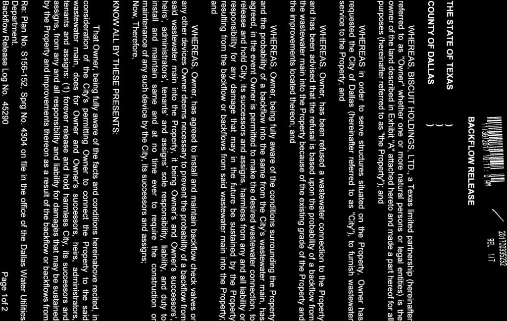
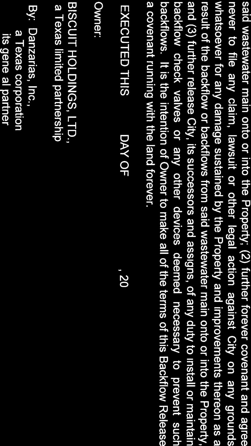
1 WASTEWATER BACKFLOW RELEASE PROCEDURES PROCEDURE FOR OBTAINING A WASTEWATER RELEASE FOR PRIVATE DEVELOPMENT PROJECTS: PLEASE NOTE THAT THE WASTEWATER BACKFLOW RELEASE DOCUMENT MUST FOLLOW THE CITY S PROCEDURES. THE DOCUMENT IS NOT CONSIDERED VALID IF RECORDED WITHOUT THE SIGNATURE OF THE CITY ATTORNEY. REQUIRED SUBMITTALS: 1. Field notes (metes and bounds description and parcel sketch) of property in accordance to the current Survey Plat Review Group Legal Description Preparation Guideline and Checklist. Include completed checklist in submittal. 2. A copy of the recorded plat of the property or the preliminary plat if property is in the process of being platted. If the property is not platted any additional property information such as previous deed dedications would be helpful. 3. Copy of current owners warranty deed. Contact information of the current ownership of the property where the agreement is located. 4. Contact information, including phone number and address of the owner/ developer, surveyor and the consulting engineer. 5. Letter from owner requesting a wastewater backflow release agreement and acknowledging that it will be recorded with deed of property. CITY PROCEDURES Submit the above items with an application as a new project to W/WW Engineering Section - OCMC Room 200. No review fee is assessed. The field notes will be routed to the Survey section for review. They will contact the surveyor/engineer if they need revision. The City surveyor will approve the field notes. The document cannot be sent to Real Estate without the approval/signature of the city surveyor. The approved field notes will be sent to the City Real Estate division of SD&C Dept. along with property deed and contact information. Real Estate will send the City forms to the property owners or authorized agents for signatures. Signed documents are reviewed / approved by City Attorney. Once approved by the City Attorney they are routed and then recorded at the County Records. Wastewater Backflow Releases recorded at the county without the City Attorney s signatures are NOT considered valid and cannot be accepted. Permits will not be released until the Backflow Release is recorded. Revised Aug. 2017
2 CITY OF DALLAS December 15, 2017 David Lam, P.E. Senior Program Manager SD&C Engineering Division Water/Wastewater Section 320 E. Jefferson Blvd., Room 200 Dallas, Texas Re: Name of Project Dear: Mr. Lam: We are fully aware that we do not meet the required finished floor elevation criteria necessary for a wastewater service connection due to the grade of the improvements on the referenced property and face the possibility of a backflow from the wastewater main. We agree to install and maintain at our expense backflow check valves or any other devices necessary to prevent the probability of a backflow from the wastewater main to the referenced property. We, our successors, heirs, administrators, tenants, and assigns agree to forever release and hold harmless the City of Dallas, its successors and assigns, from any responsibility and liability for damages that may be sustained by the referenced property and/or improvements as a result of the backflow of the wastewater main. Sincerely, Owners Name Title Company c: File Sustainable Development and Construction 320 E. Jefferson, Room 200 Dallas, Texas / Fax 214/ A City Utility Providing Regional Water and Wastewater Services Vital to Public Health and Safety.
3 Sustainable Development & Construction Engineering; Survey Plat Review Group SPRG CITY OF DALLAS RE: City Plan File No. S - Addition Name: (If Applicable) Owner Name Owner (Required) (Required) LEGAL DESCRIPTION PREPARATION GUIDELINE AND CHECKLIST The following guideline and checklist are provided to assist in the preparation of real property descriptions for fee title conveyances, rights-of-way, easements, lease agreements, license agreements, etc., either for or on behalf of the City of Dallas. Legal Descriptions will be reviewed by the Sustainable Development & Construction, Engineering Division, Survey Plat Review Group (SPRG) staff to insure substantial compliance with both the form and content outlined in these guidelines. Legal Descriptions and Parcel Sketches must comply with both the rules of the Texas Board of Professional Land Surveying and the Professional Land Surveying Practices Act. Legal Descriptions, for the purposes previously described, are defined as a written metes and bounds description of the boundary of the subject tract. A Parcel Sketch or map is a graphic depiction of the area described by the metes and bounds description. Both documents are prepared from data collected during an on the ground survey. All Legal Descriptions must include a reference to recorded monumentation (Corners of parent tract, platted subdivision, adjoining tract, etc.). The following checklist is provided for your assistance in preparing Legal Descriptions and Parcel Sketches for submittal to the Survey Plat Review Group (SPRG). SPRG NO.: ALL DOCUMENTATION REFERENCED IN THE LEGAL DESCRIPTION & PARCEL SKETCH MUST BE SUBMITTED GENERAL REQUIREMENTS APPLI- CANT CITY STAFF 1. ADD SPRG REVIEW BOX TO EACH SHEET/PAGE OF LEGAL DESCRIPTION & PARCEL SKETCH. SPRG REVIEW BOX (For SPRG use only) Reviewed by: Date: SPRG No. 2. SUBMIT 3 ORIGINALS OF THE LEGAL DESCRIPTION AND PARCEL SKETCH ON 8-1/2 X 11 PLAIN WHITE BOND, SIGNED (IN BLUE INK), SEALED, AND DATED BY THE REGISTERED PROFESSIONAL LAND SURVEYOR. Rev. 6/16 SHEET 1 OF 5
4 HEADER REQUIREMENTS 3. HEADER (USE THE ORDER THAT FOLLOWS) SEE APPENDIX (SHEET 5) FOR EXAMPLES a.) TYPE OF CONVEYANCE (I.E. WATER EASEMENT, WASTEWATER EASEMENT, STREET ABANDONMENT, DRAINAGE EASEMENT, ETC.). b.) SUBDIVISION NAME, OR PARENT ACREAGE, OR (IF IN STREET) STREET NAME. c.) LOT No. (IF APPLICABLE), CITY OF DALLAS BLOCK No. OR (IF IN STREET) ADJACENT BLOCK No.s. d.) ORIGINAL LAND SURVEY GRANTEE NAME, ABSTRACT No. e.) CITY OF DALLAS, (FILL IN COUNTY NAME) COUNTY, TEXAS 4. HEADER MUST BE SHOWN AND MATCH ON ALL SHEETS OF LEGAL DESCRIPTION & PARCEL SKETCH. 5. DO NOT PLACE OR ASSIGN EXHIBIT LABELS (I.E. EXHIBIT A, EXHIBIT B, ETC.). LEGAL DESCRIPTION; PREAMBLE REQUIREMENTS 6. DESCRIBE AREA, UNDER AN ACRE= (1234 SQ. FT., ACRES) AN ACRE AND ABOVE = (1.234 ACRES) 7. ORIGINAL LAND SURVEY GRANTEE NAME, ABSTRACT No. 8. CITY OF DALLAS BLOCK No.(S). 9. PARENT TRACT ACREAGE OR LOT, BLOCK, SUBDIVISION NAME, AND RECORDING INFORMATION AS IT APPEARS IN INSTRUMENT OF CONVEYANCE. 10. CURRENT OWNER S NAME(S). 11. TYPE OF CONVEYANCE (I.E. WARRANTY DEED, SPECIAL WARRANTY DEED, etc.) (DEED OF TRUST IS NOT ACCEPTABLE.) 12. CURRENT OWNER S DEED RECORDING INFORMATION (VOLUME AND PAGE, OR INSTRUMENT No. WITH COUNTY AND STATE.) LEGAL DESCRIPTION; SPECIFIC METES AND BOUNDS REQUIREMENTS 13. POINT OF COMMENCING (IF APPLICABLE). 14. POINT OF BEGINNING. (COMMENCE OR BEGIN AT A STREET INTERSECTION, RECORDED ADDITION CORNER, OR LOT CORNER OF A RECORDED ADDITION.) 15. BEARINGS AND DISTANCES. 16. CURVE DATA (IF APPLICABLE), TO INCLUDE: a. WHETHER CURVE IS TANGENT OR NON-TANGENT b. DIRECTION TO THE RIGHT OR LEFT c. ARC LENGTH d. RADIUS e. DELTA ANGLE f. CHORD BEARING FROM THE BEGINNING OF THE CURVE g. CHORD LENGTH Rev. 6/16 SHEET 2 OF 5
5 17. LIST CALLS TO ADJOINING PROPERTIES WITH RECORDING INFORMATION. (THIS INCLUDES CURRENT RIGHT(S)-OF-WAY.) 18. MUST TIE INTO A MINIMUM OF 2 CORNERS OF RECORD RELATED TO BOUNDARY General Rules of Procedures and Practices MONUMENTATION (b) & (c) 19. MONUMENTATION; FOUND OR SET WITH SIZE AND IDENTIFYING FEATURES (I.E. YELLOW PLASTIC CAP STAMPED JONES SURVEY ). 20. STATE A BASIS OF BEARING; SAMPLE STATEMENT; BASIS OF BEARING IS THE NORTH LINE OF FRENZY ROAD (INSERT RECORDED BEARING, I.E. BEING NORTH 00 DEGREES 00 MINUTES 00 SECONDS EAST) AS RECORDED IN VOLUME 88327, PAGE 0235, DEED RECORDS OF DALLAS COUNTY, TEXAS. STATE PLANE STATEMENT; STATE PLANE COORDINATE SYSTEM, TEXAS NORTH CENTRAL ZONE 4202, NORTH AMERICAN DATUM OF ADJUSTMENT REALIZATION 1986, 1993, CORS96, 2007 OR LEGAL; SIGNED (IN BLUE INK), SEALED, AND DATED BY THE REGISTERED PROFESSIONAL LAND SURVEYOR. 22. SHEET/PAGE No.s (I.E. SHEET/PAGE 1 OF 2, etc.). PARCEL SKETCH REQUIREMENTS 23. NORTH ARROW AND GRAPHIC SCALE MUST BE SHOWN. 24. ORIGINAL LAND SURVEY GRANTEE NAME, ABSTRACT No. 25. POINT OF COMMENCING (IF APPLICABLE). 26. POINT OF BEGINNING. 27. BEARINGS AND DISTANCES. 28. CURVE DATA (IF APPLICABLE), TO INCLUDE; a. ARC LENGTH b. RADIUS c. DELTA ANGLE d. CHORD BEARING FROM THE BEGINNING OF THE CURVE e. CHORD LENGTH 29. IF APPLICABLE; SHOW LEGEND WITH SYMBOLS FOR REFERENCE TO PARCEL SKETCH (I.E. MONUMENTS, ABBREVIATIONS, ETC.). 30. MONUMENTATION; FOUND OR SET WITH SIZE AND IDENTIFYING FEATURES (I.E. YELLOW PLASTIC CAP STAMPED JONES SURVEY ). 31. SHOW CURRENT OWNER WITH ALL RECORDING INFORMATION AS LISTED IN PREAMBLE OF LEGAL DESCRIPTION (MUST MATCH). 32. SHOW ADJOINING PROPERTIES WITH RECORDING INFORMATION AS DESCRIBED IN METES AND BOUNDS. (THIS INCLUDES CURRENT RIGHT(S)-OF-WAY.) 33. LABEL AREA, IF UNDER AN ACRE = (1234 SQ. FT., ACRES) ONE ACRE AND ABOVE = (1.234 ACRES) Rev. 6/16 SHEET 3 OF 5
6 34. SHOW AREA WITHIN IMMEDIATE PERIMETER OF PARCEL BOUNDARY MUST BE DETAILED: a. SHOW ADDITION NAME(S) b. PROPERTY OWNER NAME(S) c. LABEL APPROPRIATE NUMBERS FOR LOTS, BLOCKS, OR TRACTS, d. SHOW VOLUME AND PAGE, AND SOURCE OF RECORD (D.R.D.C.TX., ETC.). e. SHOW WIDTHS OF STREETS, ALLEYS, AND EXISTING EASEMENTS LEGIBLY. LABEL VOLUME AND PAGE AND SOURCE OF RECORD. ADD DISTANCE TIES ACROSS R.O.W. AT VARIABLE WIDTH R.O.W. f. OTHER PERTINENT DATA 35. SUBMIT DOCUMENTATION TO SUPPORT EXISTING STREET RIGHT-OF-WAY WIDTH (I.E. FILE RESEARCH; SEPARATE INSTRUMENT, PLAT, COUNTY R.O.W. MAP). THE SURVEY RECORDS VAULT AT 320 E. JEFFERSON, ROOM 314, DALLAS, TEXAS, OAKCLIFF MUNICIPAL CENTER IS A VALUABLE SOURCE OF THIS DATA. 36. STATE THE BASIS OF BEARING ON PARCEL SKETCH, (FROM AN IDENTIFIABLE SOURCE, I.E. TWO CONTROLLING MONUMENTS). SAMPLE STATEMENT; BASIS OF BEARING IS THE NORTH LINE OF FRENZY ROAD (INSERT RECORDED BEARING, I.E. BEING NORTH 00 DEGREES 00 MINUTES 00 SECONDS EAST) AS RECORDED IN VOLUME 88327, PAGE 0235, DEED RECORDS OF DALLAS COUNTY, TEXAS. STATE PLANE STATEMENT; STATE PLANE COORDINATE SYSTEM, TEXAS NORTH CENTRAL ZONE 4202, NORTH AMERICAN DATUM OF ADJUSTMENT REALIZATION 1986, 1993, CORS96, 2007 OR PARCEL SKETCH; SIGNED (IN BLUE INK), SEALED, AND DATED BY THE REGISTERED PROFESSIONAL LAND SURVEYOR. 38. SHEET/PAGE No.s (I.E. SHEET/PAGE 1 OF 2, ETC.) 39. SUBMIT A GEOMETRIC CLOSURE FOR THE BOUNDARY OF THE PARCELS (THIS IS REQUIRED IN THE PROJECT FILE PRIOR TO RELEASE, ATTACH TO SUBMITTAL): a. INCLUDE BEARINGS AND DISTANCES b. CURVE DATA TO INCLUDE: 1. DIRECTION TO THE RIGHT OR LEFT 2. ARC LENGTH 3. RADIUS 4. DELTA ANGLE 5. RADIUS 6. CHORD BEARING FROM THE BEGINNING OF THE CURVE 7. CHORD LENGTH c. PRECISION OF BOUNDARY CLOSURE (MINIMUM 1:15000) VICINITY MAP VICINITY MAPS ARE NO LONGER REQUIRED TO BE SUBMITTED. Rev. 6/16 SHEET 4 OF 5
7 THIS COMPLETED AND SIGNED LIST MUST ACCOMPANY THE THREE (3) EXECUTED ORIGINAL COPIES OF THE LEGAL DESCRIPTION AND PARCEL SKETCH EXHIBIT SUBMITTAL. COMPLETE ALL APPLICABLE ITEMS. PLACE A CHECKMARK IN THE SPACE LABELED APPLICANT. ITEMS THAT ARE NOT APPLICABLE TO YOUR SITUATION SHOULD BE LABELED N/A. ADDITIONAL COMMENTS: I, the Surveyor of Record, understand and agree that the City Staff Surveyor will require that the exhibits be resubmitted for review and approval if it is determined that this checklist contained incorrect information. By review of the submitted separate instrument(s), this Department does not assume any liability for the separate instrument(s), nor does this review release the surveyor of record from her/his responsibilities as a surveyor as set forth by the Texas Board of Professional Land Surveying. Signature: Date: Printed Name: APPENDIX HEADER EXAMPLES LICENSE AGREEMENT THOMAS JEFFERSON AVENUE ADJACENT TO BLOCK A/1234 & B/5678 STEPHEN F. AUSTIN SURVEY, ABSTRACT No. 567 CITY OF DALLAS, DALLAS COUNTY, TEXAS IN PLATED SUBDIVISION WATER EASEMENT GEORGE WASHINGTON ADDITION LOT 1, BLOCK A/234 STEPHEN F. AUSTIN SURVEY, ABSTRACT No. 567 CITY OF DALLAS, DALLAS COUNTY, TEXAS IN ACREAGE WATER EASEMENT BEING IN 89.5 ACRES BLOCK A/234 STEPHEN F. AUSTIN SURVEY, ABSTRACT No. 567 CITY OF DALLAS, DALLAS COUNTY, TEXAS Rev. 6/16 SHEET 5 OF 5
8


9
10
11

12

13
14
15 City of Dallas Real Estate Division REQUIRED COPORATE DOCUMENTATION OBJECTIVE: The City of Dallas City Attorney s Office requires proof of ownership for the requested easement, license, agreement, abandonment, etc. It is imperative that the documents are submitted in a timely manner, as this may delay the release of permits/approvals from other Departments and/or Divisions. Preparing these documents prior to the Real Estate Division s review is encouraged as a proactive measure. Please be prepared to submit these documents upon request from Real Estate. The required documents for each type of ownership is listed below: Limited Partnership (Ltd., LP) Example of Signature Block Limited Partnership Agreement Certificate of Limited Partnership Consent - For the transfer of real property, the limited partnership agreement may require the consent or ratification of general partners. If not an opinion letter from the partnership s attorney stating that such ratification is not necessary. Certificate of Incumbency (official document that lists the names of incumbent individuals and their respective corporate office within an organization) Non-Profit Corporation Example of Signature Block for authorized signing agent Certificate of Incorporation Articles of Incorporation and Bylaws Corporate Resolution Certificate of Incumbency Good Standing Certificate a good standing certificate obtained from the state Comptroller of Public Accounts in Texas, confirming the required filings of reports and payments. Rev. 7/17 Page 1 of 2
16 Limited Liability Company (LLC) Example of Signature Block for authorized signer Certificate of Formation Entity Regulations (Bylaws) Good Standing Certificate a good standing certificate obtained from the state Comptroller of Public Accounts in Texas, confirming the required filings of reports and payments. Authorization Documentation (corporate resolution authorizing the water easement and stating who will be authorized to execute the documents) Incorporated (Inc.) Example of Signature Block for signing officer Certificate of Formation Bylaws organizational documents identifying the authority and limitations of authority of officers to enter into the transaction Good Standing Certificate Corporate Resolution executed resolution of the shareholders or directors of the Grantor authorizing the proposed transaction and granting authority to the signing officer to act on behalf of the corporation. Certificate of Incumbency (official document that lists the names of incumbent individuals and their respective corporate office within an organization) Individuals (needed for each owner listed if multiple) Completed Marital Affidavit No Conflict of Interest Statement Homestead/Non-Homestead Affidavit Rev. 7/17 Page 2 of 2
DALLAS WATER UTILITIES WATER/WASTEWATER COVENANT
 DALLAS WATER UTILITIES WATER/WASTEWATER COVENANT Procedure for obtaining a water and wastewater covenant, water covenant, or wastewater covenant; Required for initial submittal: 1. One letter from the
Department of Development Services Engineering; Survey Plat Review Group SPRG
 Department of Development Services Engineering; Survey Plat Review Group SPRG CITY OF DALLAS LEGAL DESCRIPTION PREPARATION GUIDELINE AND CHECKLIST The following guideline and checklist are provided to
OTTAWA COUNTY LEGAL DESCRIPTION REVIEW GUIDELINES
 OTTAWA COUNTY LEGAL DESCRIPTION REVIEW GUIDELINES APPROVED BY: RONALD P. LAJTI, JR., P.E., P.S. OTTAWA COUNTY ENGINEER APPROVED BY: LAWRENCE HARTLAUB OTTAWA COUNTY AUDITOR EFFECTIVE DATE: January 1, 2017
2018 EASEMENT DEDICATION PACKET
 2018 EASEMENT DEDICATION PACKET (INCLUDES PARCELS OF LAND, EASEMENTS, AND RIGHTS-OF-WAY FOR PUBLIC USE) Information Packet There are various situations in which easements, rights-of-way, and parcels of
Change In The Name Of Owner (s) Of Land.
 Of Land.") Clermont County TRANSFER AND CONVEYANCE STANDARDS OF THE CLERMONT COUNTY AUDITOR AND THE CLERMONT COUNTY ENGINEER AS ADOPTED UNDER OHIO REVISED CODE SECTION 319.203, AS A RESULT OF TWO PUBLIC HEARINGS
Clermont County TRANSFER AND CONVEYANCE STANDARDS OF THE CLERMONT COUNTY AUDITOR AND THE CLERMONT COUNTY ENGINEER AS ADOPTED UNDER OHIO REVISED CODE SECTION 319.203, AS A RESULT OF TWO PUBLIC HEARINGS
Standards for All Instruments of Conveyance
 Standards for All Instruments of Conveyance Perry County, Ohio Effective Date: May 1, 1997 Effective Date of Revision: April 1, 2011 Page 2 of 12 Minimum Standards for all Instruments of Conveyance Perry
Oakland County Michigan Register of Deeds Plat Engineering, GIS, & Remonumentation Dept. Ph: (248) Fax (248)
 Fax (248)") Oakland County Michigan Register of Deeds Plat Engineering, GIS, & Remonumentation Dept. Ph: (248)-858-1447 Fax (248)-858-7466 Requirements Needed for Final Plat Approval No. General Requirements. 1 Routing
Oakland County Michigan Register of Deeds Plat Engineering, GIS, & Remonumentation Dept. Ph: (248)-858-1447 Fax (248)-858-7466 Requirements Needed for Final Plat Approval No. General Requirements. 1 Routing
CITY OF DECATUR, TEXAS
 Final Plat or Amending Plat / Replat Checklist A submittal of a complete application will facilitate a timely review. Failure of the applicant to provide required information or obtain a waiver from the
Preliminary Plat/Final Plat Application
 Melissa Municipal Center 3411 Barker Avenue Melissa, Texas 75454 Phone: (972) 838-2036 Applicant: Date: Address: Phone: Contact: Fax: E-mail: Propose Addition Name: Acres: Existing Zoning: Propose Zoning:
FINAL PLAT. Community Development Department 8101 Ralston Road Arvada, Colorado 80002
 FINAL PLAT Community Development Department 8101 Ralston Road Arvada, Colorado 80002 September 2015 FINAL SUBDIVISION PLAT Final Subdivision Plat Review Applications for a Final Plat shall be submitted
SUBDIVISION AND LAND DEVELOPMENT. 185 Attachment 20
 185 Attachment 20 APPENDIX S Plat No. Date of Submission Twp. Fee $ Dauphin Co. Fee $ TOWNSHIP OF DERRY SUBDIVISION OR LAND DEVELOPMENT PLAN SUBMISSION APPLICATION This block for Twp. use only 1. Title
REQUIREMENTS FOR ALL INSTRUMENTS OF CONVEYANCE IN HARDIN COUNTY, OHIO
 REQUIREMENTS FOR ALL INSTRUMENTS OF CONVEYANCE IN HARDIN COUNTY, OHIO Effective Date: Michael L. Smith, P.E., P.S. Hardin County Engineer Michael T. Bacon Hardin County Auditor 1 I. GENERAL In compliance
MINOR SUBDIVISION PLAT
 MINOR SUBDIVISION PLAT Community Development Department 8101 Ralston Road Arvada, Colorado 80002 MINOR SUBDIVISION PLAT Subdivisions consisting of five (5) or fewer lots are eligible for the minor subdivision
MINOR SUBDIVISION PLAT
 MINOR SUBDIVISION PLAT Community Development Department 8101 Ralston Road Arvada, Colorado 80002 September 2015 MINOR SUBDIVISION PLAT Subdivisions consisting of five (5) or fewer lots are eligible for
RULES OF THE GEORGIA STATE BOARD OF REGISTRATION FOR PROFESSIONAL ENGINEERS AND LAND SURVEYORS CHAPTER APPLICATIONS TABLE OF CONTENTS
 RULES OF THE GEORGIA STATE BOARD OF REGISTRATION FOR PROFESSIONAL ENGINEERS AND LAND SURVEYORS CHAPTER 180-7 APPLICATIONS TABLE OF CONTENTS 180-7-.07 Maps and Plats. All maps, plats and similar documents
Final Plat Approval of a Major Subdivision Application Packet
 Final Plat Approval of a Major Subdivision Application Packet 1. Application Packet. Be sure to complete and submit all the required materials that are a part of this Application Packet. Failure to do
APPROVAL REQUIREMENTS
 APPROVAL REQUIREMENTS FOR INSTRUMENTS OF CONVEYANCE IN ERIE COUNTY, OHIO DRAFT Requirements for all instruments of Conveyance in Erie County, revised and effective, 2014. An Erie County policy governing
STANDARDS GOVERNING CONVEYANCES OF REAL PROPERTY
 STANDARDS GOVERNING CONVEYANCES OF REAL PROPERTY Hancock County, Ohio Charity A. Rauschenberg, Hancock County Auditor Steven C. Wilson, Hancock County Engineer Revised: March 1, 2007 TRANSFER AND CONVEYANCE
Requirements For All Instruments of Conveyance In Monroe County, Ohio. Transfer and Conveyance Standards of the Monroe County Auditor & Engineer
 Requirements For All Instruments of Conveyance In Monroe County, Ohio Transfer and Conveyance Standards of the Monroe County Auditor & Engineer Effective November 8, 2013 1 TRANSFER PROCEDURES FOR MONROE
PARCEL MAP CHECK ENG
 Engineering Division 201 North Broadway, Escondido, CA 92025 (760) 839-4651, FAX (760) 839-4597 PARCEL MAP CHECK ENG To: Date: Project: Site Address Check No. Attn: Via: The attached plans have been reviewed
Plats and subdivisions; mapping requirements. (a) Size Requirements. All land plats presented to the register of deeds for recording in the
 Size Requirements. All land plats presented to the register of deeds for recording in the") 47-30. Plats and subdivisions; mapping requirements. (a) Size Requirements. All land plats presented to the register of deeds for recording in the registry of a county in North Carolina after September
47-30. Plats and subdivisions; mapping requirements. (a) Size Requirements. All land plats presented to the register of deeds for recording in the registry of a county in North Carolina after September
COACHELLA VALLEY WATER DISTRICT STANDARDS FOR LEGAL DESCRIPTIONS AND PLATS
 COACHELLA VALLEY WATER DISTRICT STANDARDS FOR LEGAL DESCRIPTIONS AND PLATS The following is the procedure for processing legal descriptions and plats (exhibits) for grants of easements, grant deeds, quitclaim
The Filing Fee for a Minor Plat is $ PLUS $20.00 per lot created
 DEPARTMENT OF COMMUNITY DEVELOPMENT MINOR PLAT PROCEDURE The Filing Fee for a Minor Plat is $250.00 PLUS $20.00 per lot created Description: The purpose of a Minor Plat is to allow property to be platted
MINOR SUBDIVISION PLAT CHECKLIST
 MINOR SUBDIVISION PLAT CHECKLIST Project Name: Tax ID #: Project Number: Date: _ Reviewed By: Telephone: NOTES: All lots on septic systems must comply with the Fulton County Health Department requirements
CITY OF LEE S SUMMIT MINOR PLAT PROCESS. Purpose of Minor Plats
 MINOR PLAT PROCESS Purpose of Minor Plats The City of Lee s Summit requires that all property be platted before a building permit is issued. Platting involves the subdivision of land into lots or tracts.
Final Plat Approval of a Minor Subdivision Application Packet
 Final Plat Approval of a Minor Subdivision Application Packet 1. Application Packet. Be sure to complete and submit all the required materials that are a part of this Application Packet. Failure to do
STANDARDS GOVERNING CONVEYANCES OF REAL PROPERTY IN DARKE COUNTY, OHIO
 STANDARDS GOVERNING CONVEYANCES OF REAL PROPERTY IN DARKE COUNTY, OHIO As directed by Section 319.203 of the Ohio Revised Code which states The County Auditor and the County Engineer shall adopt standards
SUBDIVISION APPLICATION
 SUBDIVISION APPLICATION Preliminary Plat Minor Plat Final Plat Amended Plat Applicant Name: Owner (if different from applicant) Name: Company: Company: Address: Address: City, State, Zip City, State, Zip
Ballard City Final Plat Check List
 Ballard City Final Plat Check List TO BE COMPLETED BY BOTH THE DEVELOPER AND THE CITY Design: Check: Check each of the following items for compliance with adopted City Standards, Titles, General Plans
WYANDOT COUNTY BASIC STANDARDS FOR THE APPROVAL OF REAL ESTATE DEED TRANSFERS & LAND CONTRACT AGREEMENTS
 GENERAL In compliance with Section 315.251 of the Ohio Revised Code, the County Auditor and the County Engineer have adopted these written standards governing the conveyance of real property in Wyandot
PLANNING AND DEVELOPMENT DEPARTMENT PRELIMINARY PLAT APPLICATION
 PLANNING AND DEVELOPMENT DEPARTMENT PRELIMINARY PLAT APPLICATION IT IS INCUMBENT UPON THE APPLICANT TO SUBMIT COMPLETE AND CORRECT INFORMATION. ANY MISLEADING, DECEPTIVE, INCOMPLETE OR INCORRECT INFORMATION
FINAL MAP PLAN CHECK
 Engineering Division 201 North Broadway, Escondido, CA 92025 (760) 839-4651, FAX (760) 839-4597 FINAL MAP PLAN CHECK To: Date: Project: Address: Check No: Attn: VIA: The attached FINAL MAP has been reviewed
DAWSON COUNTY MINOR PLAT REVIEW CHECKLIST $50.00 FEE PER PLAT REVIEW, $5.00 FEE FOR SCAN & CD FOR RECORDING
 DAWSON COUNTY MINOR PLAT REVIEW CHECKLIST $50.00 FEE PER PLAT REVIEW, $5.00 FEE FOR SCAN & CD FOR RECORDING NAME ON PLAT: CONTACT/PHONE #: NAMED STREET/ADDRESS: LAND LOT: DISTRICT: SECTION: ZONING: SETBACKS:
City of Lakewood Plat Specifications
 City of Lakewood Plat Specifications Revised 12/15/2015 Plat Checklist.1 Notes, Certifications and Acknowledgements..5 Electronic Submittal Information... 20 Sheet Layout.21 A Professional Land Surveyor,
Minimum Requirements. In Carroll County, Ohio
 Minimum Requirements For Instruments of Conveyance In Carroll County, Ohio Revision History: Original Effective Date: June 1, 2000 Revision Effective Date: October 2, 2017 Foreword Section 319.203 of the
BOSSIER CITY PARISH METROPOLITAN PLANNING COMMISSION 620 Benton Rd. Bossier City, LA Phone: Fax: PRELIMINARY PLAT
 (OFFICE USE ONLY) Application Fee: Paid: Date: CASE # Project Information BOSSIER CITY PARISH METROPOLITAN PLANNING COMMISSION 620 Benton Rd. Bossier City, LA 71111 Phone: 318-741-8824 Fax: 318-741-8827
Final Subdivision Plat
 Final Subdivision Plat Application Packet Public Works Department New Development Division 175 East 200 North St. George, UT 84770 Office (435) 627-4120 Dear Applicant, This packet has been prepared to
STANDARDS FOR PLATS OF SURVEYS, LEGAL DESCRIPTIONS, RECORD PLANS AND CONDOMINIUM PLANS
 OFFICE OF THE MONTGOMERY COUNTY ENGINEER STANDARDS FOR PLATS OF SURVEYS, LEGAL DESCRIPTIONS, RECORD PLANS AND CONDOMINIUM PLANS INDEX Definitions Electronic Data Submittal Program Page i Page ii I. Adoption
City of Fort Lupton Amended Plat Process
 City of Fort Lupton Amended Plat Process Purpose The Amended Plat process is an administrative process to amend a recorded Plat. An Amended Subdivision is an administrative revision to a recorded Subdivision
A lot line or terminology adjustment will be reviewed concurrently with any other development review application(s) that are required.
 that are required.") RELATED FACTS TO KNOW: Adams County Recording Requirements, Annexation, Common Wall Subdivision, Development Plan (PUD Development Permit), Fees, Helpful Contact Information, Neighborhood Meeting, Park
RELATED FACTS TO KNOW: Adams County Recording Requirements, Annexation, Common Wall Subdivision, Development Plan (PUD Development Permit), Fees, Helpful Contact Information, Neighborhood Meeting, Park
Real Property Services Division 2016 SUBDIVISION PLAT CHECKLIST
 Real Property Services Division 2016 SUBDIVISION PLAT CHECKLIST Created primarily for the use of Surveyors, CAD operators, and technical support staff for the preparation of subdivision plats. INTRODUCTION:
APPENDIX C: FINAL PLAT REVIEW CHECKLIST
 FINAL PLAT REVIEW CHECKLIST The Office of Permitting Services processes final record plats though the City agencies for review and approval and ultimate recording of the final plat at the Orange County
COUNTY OF ALBEMARLE APPLICATION FOR FAMILY DIVISION. Family Division = $742 (Provide 5 copies of plat)
") Page 1 APPLICATION FOR FAMILY DIVISION Family Division = $742 (Provide 5 copies of plat) Tier 2 Groundwater Review = $355 (Required for all plats showing lots less than 21 acres) Tier 3 Groundwater Review
Page 1 APPLICATION FOR FAMILY DIVISION Family Division = $742 (Provide 5 copies of plat) Tier 2 Groundwater Review = $355 (Required for all plats showing lots less than 21 acres) Tier 3 Groundwater Review
Group Sewer Only** 80 Ft Frontage* 20,000 Sq. Ft. (.46 acre) Minimum** 120 Ft Frontage* 20,000 Sq. Ft. (.46acre) Minimum** 150 Ft Frontage*
 Minimum** 120 Ft Frontage* 20,000 Sq. Ft. (.46acre) Minimum** 150 Ft Frontage*") Residential Lots Minimum Chart The minimum lot size of any minor subdivision where there is no public sewers shall be as shown below or as required by township zoning and/or the Tuscarawas General Health
Residential Lots Minimum Chart The minimum lot size of any minor subdivision where there is no public sewers shall be as shown below or as required by township zoning and/or the Tuscarawas General Health
Survey and Recording Requirements
 Article C: Sec. 14-1-40 Survey and Recording Requirements Survey Requirements. (a) (b) (c) Prior to the final approval of land divisions to which this Chapter applies, the owner of the land shall have
(5) Multiple Transfer Fees collectively paid with one check will not be accepted.
 Multiple Transfer Fees collectively paid with one check will not be accepted.") TRANSFER AND CONVEYANCE STANDARDS OF THE FRANKLIN COUNTY AUDITOR AND THE FRANKLIN COUNTY ENGINEER AS ADOPTED UNDER OHIO REVISED CODE SECTION 319.203 EFFECTIVE JULY 1, 1996 AMENDED JULY 14, 1997 AMENDED
TRANSFER AND CONVEYANCE STANDARDS OF THE FRANKLIN COUNTY AUDITOR AND THE FRANKLIN COUNTY ENGINEER AS ADOPTED UNDER OHIO REVISED CODE SECTION 319.203 EFFECTIVE JULY 1, 1996 AMENDED JULY 14, 1997 AMENDED
Requirements for All Instruments of Conveyance in Logan County, Ohio
 Requirements for All Instruments of Conveyance in Logan County, Ohio Effective Date: April 11, 1997 It is the intent of these requirements to provide a standard method of checking legal descriptions for
SUBDIVISION APPLICATION
 STAFF USE ONLY Date Submitted: Received by: Fee paid: Project # REQUIRED SUBMITTALS Application Fee: $600.00 (up to 5 lots) + $50.00 (per lot above 5) Publication Fee: $300.00 Mailing Fee: $6.00 per hearing
A Final Plat will be reviewed concurrently with any other development review application(s) that is required.
 that is required.") RELATED FACTS TO KNOW: Adams County Recording Requirements, Annexation, Common Wall Subdivision, Development Plan (PUD Development Permit), Fees, Helpful Contact Information, Lot Line Adjustment, Neighborhood
RELATED FACTS TO KNOW: Adams County Recording Requirements, Annexation, Common Wall Subdivision, Development Plan (PUD Development Permit), Fees, Helpful Contact Information, Lot Line Adjustment, Neighborhood
R/W PREQUALIFICATION ODOT, 3/14/2018
 R/W PREQUALIFICATION ODOT, 3/14/2018 BRETT SHEARER, C.O. REAL ESTATE PROPOSED RIGHT OF WAY DESIGN 172 PROPOSED RIGHT OF WAY DESIGN PROPOSED RIGHT OF WAY DESIGN Section 3200 Types of Title 173 PROPOSED
CHAPTER FINAL AND PARCEL MAPS
 CHAPTER 19.48 FINAL AND PARCEL MAPS Section Page 19.48.010 General... IV-25 19.48.020 Phasing... IV-25 19.48.030 Survey Required... IV-26 19.49.040 Form... IV-26 19.48.050 Contents... IV-27 19.48.060 Preliminary
PLANNING COMMISSION SUBDIVISION PLAT APPLICATION
 PLANNING COMMISSION SUBDIVISION PLAT APPLICATION Economic Development Department 3468 North Fulton Avenue Hapeville, Georgia 30354 Phone - 404.669.8269 Fax 404.669.3302 Rev. 09/23/16 1 The following information
Residential Major Subdivision Review Checklist
 Residential Major Subdivision Review Checklist Plan Submittal Requirements: 2 full sets of stamped plans Electric submittal - all plans contained in a single PDF 3 full sets if commercial kitchen or dining
TRANSFER AND CONVEYANCE STANDARDS OF THE PICKAWAY COUNTY AUDITOR AND THE PICKAWAY COUNTY ENGINEER
 TRANSFER AND CONVEYANCE STANDARDS OF THE PICKAWAY COUNTY AUDITOR AND THE PICKAWAY COUNTY ENGINEER Melissa A. Betz, Auditor Robert E. Parker, P.E., P.S., Engineer AS ADOPTED UNDER OHIO REVISED CODE SECTION
BOROUGH OF HELLERTOWN 685 Main St., Hellertown PA Phone: Fax:
 SUBDIVISION / LAND DEVELOPMENT REVIEW CHECKLIST Subdivision / Land Development Preliminary Plan Preliminary Plan Checklist A scaled plan not less that 1 = 100 feet (422.01) Proposed subdivision name or
Subdivisions. CITY OF OAK HARBOR Development Services Department
 CITY OF OAK HARBOR Development Services Department Subdivisions Finall Platt Applicatti ion Review Prrocess VII What is a Subdivision? A subdivision is the division of land into ten or more lots, tracts,
APPENDIX C: PLAT SPECIFICATIONS AND CERTIFICATES
 APPENDIX C: PLAT SPECIFICATIONS AND CERTIFICATES A. Drawing. All plats for recording must be submitted on photographically reproducible and dimensionally stable polyester sheets such as Mylar, Cronar or
Final Plat Mapping Requirements
 CURRENT PLANNING DIVISION 410 E. 5 th Street Loveland, CO 80537 970-962-2523 eplan-planning@cityofloveland.org cityofloveland.org/dc Final Plat Mapping Requirements All Final plats shall comply with the
PRELMINARY PLAT CHECKLIST
 PRELMINARY PLAT CHECKLIST A. All preliminary plat submitted for approval shall be prepared by a Registered Professional Land Surveyor. B. Preliminary plats must be drawn to a scale of XXX with such accuracy
Auditor's Office Tuscarawas County
 Auditor's Office Tuscarawas County MATT JUDY, Auditor Telephone 125 E. High Avenue (330) 365-3220 New Philadelphia, Ohio 44663 Fax: (330) 365-3397 TO: FROM: Title Companies, Surveyors, Attorneys & Financial
MAP CHECKLIST (Rev 02/13)
") Note: [ ] 1 is Gov. Code, [ ] 2 is BP Code, [ ] 3 is S.M.Co. Ord. MAP CHECKLIST (Rev 02/13) COUNTY OF SAN MATEO TRACT NO. INITIAL SUBMISSION Final Map Conditional Approval Letter and Approved Tentative
Note: [ ] 1 is Gov. Code, [ ] 2 is BP Code, [ ] 3 is S.M.Co. Ord. MAP CHECKLIST (Rev 02/13) COUNTY OF SAN MATEO TRACT NO. INITIAL SUBMISSION Final Map Conditional Approval Letter and Approved Tentative
CARROLL COUNTY BUREAU OF DEVELOPMENT REVIEW OFF-CONVEYANCE SUBMITTAL CHECKLIST AND REVIEW FEE SHEET NOTICE: INCOMPLETE SUBMITTALS WILL BE RETURNED
 CARROLL COUNTY BUREAU OF DEVELOPMENT REVIEW OFF-CONVEYANCE SUBMITTAL CHECKLIST AND REVIEW FEE SHEET An off-conveyance submittal shall include all items as specified in Section 103-7 of the Code of Public
Types of Scripts & Uses
 Types of Scripts & Uses Standard Sanitary Sewer and Storm Sewer Easement 3.11 Standard Blue Border 1. A Single Person 2. A Married Couple 3. Family Trust 4. Subdivision Trustees 5. Partnership 6. Power
Residential Minor Subdivision Review Checklist
 Residential Minor Subdivision Review Checklist Plan Submittal Requirements: 2 full sets of stamped plans Electric submittal - all plans contained in a single PDF 3 full sets if commercial kitchen or dining
LAND USE PERMIT APPLICATION
 LAND USE PERMIT APPLICATION Date Application No. TYPE OF PERMIT Subdivision Short Plat Conditional Use Binding Site Plan Final Plat Final Short Plat Variance Final Binding Site Plan Plat Amendment Short
CITY OF SARALAND PRELIMINARY SUBDIVISION PLAT REVIEW
 PRELIMINARY SUBDIVISION PLAT REVIEW Application Number: Date Plat Submitted: Name of Subdivision: Name of Owner: Owner Address: (Street or P.O. Box) Telephone #: (City) (State) (Zip) E-mail: Name of Authorized
Minor Subdivision Application
 FOR PLANNING USE ONLY Application # SD Application Fee $1,000.00 Receipt No. Filing Date Completeness Date Minor Subdivision Application A. PROJECT INFORMATION 1. Project Name: 2. Address of Subject Property:
CITY OF BEVERLY HILLS Department of Public Works and Transportation Civil Engineering Division FINAL MAP SUBMITTAL PROCESS Transmitted
 CITY OF BEVERLY HILLS Department of Public Works and Transportation Civil Engineering Division FINAL MAP SUBMITTAL PROCESS Transmitted From To* Planning Department Civil Engineering Division RKA Consulting
MINOR PLAT. The following documents are provided as required by the City of Conroe for use in the above titled platting submittals:
 Public Works - Engineering Division CITY OF CONROE MINOR PLAT The following documents are provided as required by the City of Conroe for use in the above titled platting submittals: Submittal Questionnaire
CITY OF FAYETTEVILLE, ARKANSAS FINAL PLAT FOR STAFF USE ONLY FINAL PLAT FEE: $ $ Date Application Submitted: Date Accepted as Complete:
 CITY OF FAYETTEVILLE, ARKANSAS FINAL PLAT FOR STAFF USE ONLY FINAL PLAT FEE: $200.00-$800.00 Date Application Submitted: Date Accepted as Complete: Project Number: Public Hearing S-T-R: PP#: Zone: Please
TRANSFER PROCEDURES FOR WASHINGTON COUNTY, OHIO
 TRANSFER PROCEDURES FOR WASHINGTON COUNTY, OHIO The following requirements are adopted and established in conjunction with the Washington County Engineer and the Washington County Auditor as prescribed
CHAPTER 32 SUBDIVISIONS SECTION TITLE PAGE NO.
 Page 1 of 46 CHAPTER 32 SUBDIVISIONS SECTION TITLE PAGE NO. SECTION 32-1 Purpose of Ordinance 3 SECTION 32-2 Definitions 3 SECTION 32-3 Staff Sketch Review 4 SECTION 32-4 Subdivision and PUD Plats Required
PROCEDURES TO SUBDIVIDE / LOT COMBINATION
 G Department of Planning & Community Development @ Jefferson Station 1526 E. Forrest Avenue Suite 100 East Point, GA 30344 404.270.7029 (Phone) 404.209.5148 (Fax) www.eastpointcity.org PROCEDURES TO SUBDIVIDE
Map Filing Law. 46: Effective date This act shall take effect January first, one thousand nine hundred and fiftyfour.
 46:23-9.8. Effective date This act shall take effect January first, one thousand nine hundred and fiftyfour. L.1953, c. 358, p. 1941, s. 8. 46:23-9.9. Short title This act shall be known and may be cited
PRELIMINARY PLAT CHECK LIST
 PRELIMINARY PLAT CHECK LIST Name of Proposed Subdivision: The following items must be included with the initial submittal of a Preliminary Plat: Application, filled out completely Project Narrative Pre-application
Conveyance Standards. Boundary Survey Requirements. Adams County, Ohio
 Conveyance Standards And Boundary Survey Requirements Adams County, Ohio OFFICE OF THE ADAMS COUNTY AUDITOR DAVID GIFFORD 110 WEST MAIN STREET WEST UNION, OH 45693 OFFICE OF THE ADAMS COUNTY ENGINEER DAVID
Application for Preliminary Plat Checklist
 Application for Preliminary Plat Checklist Note: No portion of an existing parcel may be sold or transferred to another party without first legally subdividing the property according to the City of Richmond
AMENDING PLAT REQUIREMENTS Revised
 City of University Park AMENDING PLAT REQUIREMENTS Revised 9-3-2014 1. The amending plat is prepared with the appropriate certificates printed on the document and three (3) 24 x 36 paper copies are submitted
R/W PREQUALIFICATION ODOT, 3/14/2018 PROPERTY MAP SHEET
 R/W PREQUALIFICATION ODOT, 3/14/2018 3A Title Block 3B Sheet Heading 3C Station Limit Flags 3D Revision Block 3E Ownership Name and Number 3F Centerline Stationing 3G Proposed R/W and Pavement 3H Structures
Boundary Line Adjustment Application
 Boundary Line Adjustment Application A COMPLETE APPLICATION is required at the time of submittal. REQUIRED SUBMITTALS: 1. Application form 2. Application Fee - $500.00. 3. Current title report 4. Three
Delaware County Transfer Standards
 Delaware County Transfer Standards Delaware County Auditor David A. Yost Delaware County Engineer Chris Bauserman Adopted in 1997, Amended in 1999 Dave Yost County Auditor Chris Bauserman County Engineer
SUBMITTAL REQUIREMENTS: The number indicates the number of copies for submittal (if applicable).
.") Office Use Only Preliminary Long Plat Long Subdivision Applicant Checklist PLANNING, COMMUNITY, & ECONOMIC DEVELOPMENT DEPARTMENT FINAL LONG PLAT LONG SUBDIVISION CHECKLIST Mailing Address: P.O. Box 547,
Office Use Only Preliminary Long Plat Long Subdivision Applicant Checklist PLANNING, COMMUNITY, & ECONOMIC DEVELOPMENT DEPARTMENT FINAL LONG PLAT LONG SUBDIVISION CHECKLIST Mailing Address: P.O. Box 547,
REQUIREMENTS FOR ALL INSTRUMENTS OF CONVEYANCE IN GREENE COUNTY
 REQUIREMENTS FOR ALL INSTRUMENTS OF CONVEYANCE IN GREENE COUNTY A Greene County policy governing procedures and requirements for acceptance of documents for instruments of conveyance is hereby established.
Synergy Park Addition (Companion to item 3)
") Synergy Park Addition (Companion to item 3) Attachments: 1. Locator 2. Replat staff report 3. Replat W P G r es rg eo e s Bu hh wy Lot 6A 4.02-acres Lot 4C 13.02-acres Fran k Lots 4C and 6A, Block A Synergy
Synergy Park Addition (Companion to item 3) Attachments: 1. Locator 2. Replat staff report 3. Replat W P G r es rg eo e s Bu hh wy Lot 6A 4.02-acres Lot 4C 13.02-acres Fran k Lots 4C and 6A, Block A Synergy
COUNTY OF ALBEMARLE APPLICATION FOR RURAL SUBDIVISION
 Page 1 APPLICATION FOR RURAL SUBDIVISION The term rural subdivision means a type of subdivision that is located in the rural areas which results in two or more lots for the purpose of transfer of ownership
City of Colleyville Community Development Department. Subdivision Application Packet
 Community Development Department Subdivision Application Packet 1 Development Application Fees 100 Main Street Colleyville TX 76034 817.503.1050 Zoning Zoning Change $ 500 + $5 per acre Planned Unit Development
Notice of Public Hearings (effective July 14, 2003) Transfer and Conveyance Standards New Information on Proposed Transfer and Conveyance Standards
 Transfer and Conveyance Standards New Information on Proposed Transfer and Conveyance Standards") Notice of Public Hearings (effective July 14, 2003) Transfer and Conveyance Standards New Information on Proposed Transfer and Conveyance Standards In accordance with Ohio Revised Code 319.203, Crawford
Notice of Public Hearings (effective July 14, 2003) Transfer and Conveyance Standards New Information on Proposed Transfer and Conveyance Standards In accordance with Ohio Revised Code 319.203, Crawford
APP. FEE: $ DATE & TIME LOCATION: 1/4 SECTION SECTION TOWNSHIP RANGE STREET ADDRESS AND GENERAL LOCATION OF PROPERTY CITY, STATE PHONE (DAY):
:") REVERSION TO ACREAGE PURSUANT TO N.R.S. 278.490 through 478.4965 Elko County Planning & Zoning 155 South 9th Street, Elko, NV 89801 (775) 738-6816 or 738-2266 APPLICATION MUST BE SUBMITTED WITH ALL REQUIRED
REVERSION TO ACREAGE PURSUANT TO N.R.S. 278.490 through 478.4965 Elko County Planning & Zoning 155 South 9th Street, Elko, NV 89801 (775) 738-6816 or 738-2266 APPLICATION MUST BE SUBMITTED WITH ALL REQUIRED
REQUIREMENTS For Subdivision Plats, Administrative Subdivision Plats, Deposit Surveys and Deeds December 2016
 REQUIREMENTS For Subdivision Plats, Administrative Subdivision Plats, Deposit Surveys and Deeds December 2016 General Requirements - All plats shall have the information necessary to delineate and reestablish
City of Palmetto Florida
 Date Submitted: CIT A9LME o City of Palmetto Florida Final Plat Application PROJECT NAME: Final Plat Review Small Scale 1, 500 Plans consistent with a prior preliminary Under 10 acres) Site Plan approval
Division of Land Application
 FOR PLANNING USE ONLY Application # DIV Application Fee Receipt No. Filing Date Completeness Date Division of Land Application A. PROJECT INFORMATION 1. Project Name: 2. Address of Subject Property: 3.
LAND CONVEYANCE STANDARDS AND REQUIREMENTS FOR APPROVALS OF DEED DESCRIPTIONS, SURVEYS AND PLATS IN MEDINA COUNTY, OHIO
 LAND CONVEYANCE STANDARDS AND REQUIREMENTS FOR APPROVALS OF DEED DESCRIPTIONS, SURVEYS AND PLATS IN MEDINA COUNTY, OHIO PREPARED BY THE OFFICE OF THE MEDINA COUNTY AUDITOR AND THE OFFICE OF THE MEDINA
C I T Y O F M c K I N N E Y PLANNING
 C I T Y O F M c K I N N E Y PLANNING 221 N. TENNESSEE STR EE T, McKI NNEY, TEXA S 75069 CONTENTS Approval Process Flowchart Letter of Intent Requirements Plat/Replat Submittal Checklist Plat/Replat Fee
Township of Little Egg Harbor Planning Board 665 Radio Road Little Egg Harbor, New Jersey Phone: ext. 221 Fax:
 BLOCK(S) LOT(S) Township of Little Egg Harbor Planning Board 665 Radio Road Little Egg Harbor, New Jersey 08087 Phone: 609-296-7241 ext. 221 Fax: 609-294-3040 Development Application Amended Development
DUSTY RHODES HAMILTON COUNTY AUDITOR WILLIAM W. BRAYSHAW HAMILTON COUNTY ENGINEER
 DUSTY RHODES HAMILTON COUNTY AUDITOR www.hamiltoncountyauditor.org WILLIAM W. BRAYSHAW HAMILTON COUNTY ENGINEER www.hamilton-co.org/engineer As Adopted Under Ohio Revised Code Section 319.203 Effective
Lake County, Ohio USA
 Lake County, Ohio USA Christoper A. Galloway Lake County Auditor TRANSFER AND CONVEYANCE STANDARDS OF THE LAKE COUNTY AUDITOR AND THE LAKE COUNTY ENGINEER ADOPTED PURSUANT TO OHIO REVISED CODE SECTION
SECTION 6 - APPROVAL OF PLATS. Whenever any subdivision of land is proposed, and before any permit for the
 SECTION 6 - APPROVAL OF PLATS 6-1 APPROVAL REQUIRED BEFORE SALE Whenever any subdivision of land is proposed, and before any permit for the erection of a structure shall be granted, the subdivider or his
SUBDIVISION APPLICATION: RECOMBINATION PLAT or EXEMPT PLAT
 SUBDIVISION APPLICATION: RECOMBINATION PLAT or EXEMPT PLAT Pursuant to Article 7, Section 155.706 of the Unified Development Code, an owner of land within the jurisdiction of the Town (or a duly authorized
Plat Checklist PLAT TYPES AND DESCRIPTIONS
 Master Plan / Revision to Master Plan (For Platting Purposes Only) Preliminary/Final Plat Preliminary Plat Final Plat Minor Plat Replat Amended Plat Plat Checklist So that we may efficiently review your
PARCEL MAP CHECKLIST
 PARCEL MAP NO. Note: [ ] 1 is Gov. Code, [ ] 2 is BP Code, [ ] 3 is S.M.Co. Ord. PARCEL MAP CHECKLIST COUNTY OF SAN MATEO (Rev. 04/10) INITIAL SUBMISSION - PARCEL MAP Conditional Approval Letter and Approved