Community Development Department Council Chambers, 7:30 PM, July 20, 2017
|
|
|
- Oswin Bryant
- 5 years ago
- Views:
Transcription
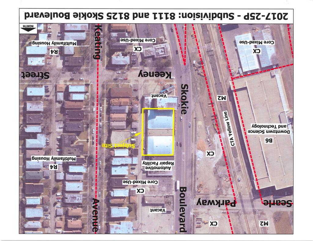
1 STAFF REPORT P: Subdivision Community Development Department Council Chambers, 7:30 PM, July 20, 2017 To: From: Re: Paul Luke, Chairman, Skokie Plan Commission Mike Voitik, Planning Technician P: Subdivision 8111 and 8125 Skokie Boulevard Related Case P: Special Use Permit General Information Location Purpose Petitioner Size of Site Existing Zoning & Land Use Adjacent Zoning & Land Use Comprehensive Plan 8111 and 8125 Skokie Boulevard To resubdivide 7 existing lots into 1 new lot Ignite Holdings, LLC, on behalf of Ignite Gaming Lounge 20,243 square feet (0.464 acres) with frontage on Skokie Boulevard CX Core Mixed-Use vacant commercial buildings North South East West CX Core Mixed-Use automotive repair facility, vacant commercial building CX Core Mixed-Use vacant commercial building, vacant lot CX Core Mixed-Use detached residences, 3- or more unit multifamily residences CX Core Mixed-Use CTA Yellow Line Oakton-Skokie Station The site is designated as pedestrian oriented mix. SITE INFORMATION A public sidewalk and Village streetscaping run along Skokie Boulevard. Overhead utilities run along the west side of the public alley to the east of the subject site. The site is directly served by the CTA 54A North Cicero/Skokie Blvd. The CTA Yellow Line Skokie-Oakton station is located across the street from the subject site. The CTA 97 Skokie and Pace 210 Lincoln Avenue buses run along Oakton Street one and a half blocks to the south. VOSDOCS-# v1-Staff_Report_-_ P_-_Subdivision 8111_and_8125_Skokie_Boulevard.doc 1 of 3
2 PETITIONER S SUBMITTAL The petitioner is requesting to resubdivide 7 lots into 1 lot at 8111 and 8125 Skokie Boulevard in a CX Core Mixed-Use district. The new lot will contain a renovated commercial building that will house a games arcade establishment along with several parking spaces and drop-off and loading zones (case P). The subdivision is necessary because the existing property spans multiple subdivisions and Cook County does not allow tax parcels in separate subdivisions to be combined through the simple PIN consolidation process. The subdivision will include a 2-foot-wide dedication for right-of-way along the east side of the subject site in order to allow the alley right-of-way width to be widened from 8 feet to 10 feet from platted centerline, as required by 94-6(5)a. of the Village Code. STAFF ANALYSIS Comments All pertinent departments and divisions were offered an opportunity to comment on this case. The Planning Division supports the proposed subdivision. The subdivision will meet all requirements of the Village Code and Map Data Policy. All other departments and divisions did not respond or approved the request without comment. STAFF RECOMMENDATIONS Staff recommends that the petitioner s request to resubdivide 7 lots into 1 lot at 8111 and 8125 Skokie Boulevard in a CX Core Mixed-Use district be APPROVED subject to the conditions listed below. RECOMMENDED SUBDIVISION CONDITIONS 1. Upon the passage of the ordinance by the Board of Trustees, the Mylar of the 8125 Skokie Blvd Subdivision must be submitted to the Village with all signatures other than Village staff or elected officials. 2. The 8125 Skokie Blvd Subdivision shall be effective upon its recording by the Village in the Office of the Recorder of Deeds of Cook County, Illinois. 3. All monuments must be set no later than 1 year after the date of the recording of the plat. 4. The petitioner must submit to the Planning Division electronic files of the plat of subdivision in approved and finalized form. The files must be scaled drawing files in AutoCAD format (version 2010 or older). The drawings must be formatted to SPCS, NAD83, HARN 2007, with SPCS north being straight up, and the primary units in U.S. Survey Feet. All elements must be contained within a single file, no XREF or PDF attachment files shall be used. 5. If work is to be performed on public property or if public property is utilized or impacted during construction and or development, the owners must provide, or must cause the developer and/or contractor to provide, the Village of Skokie with VOSDOCS-# v1-Staff_Report_-_ P_-_Subdivision 8111_and_8125_Skokie_Boulevard.doc 2 of 3
3 a certificate of insurance naming the Village of Skokie as additionally insured for any and all claims related to any and all work. The owners shall hold, and shall cause the developer and/or contractor to hold, the Village of Skokie harmless and indemnify the Village for any and all claims for property damage or personal injury related to work on or use of public property. 6. The petitioner must comply with all Federal and State statutes, laws, rules and regulations and all Village codes, ordinances, rules, and regulations. ATTACHMENTS Skokie Blvd Subdivision, dated June 11, Plat of Survey, dated February 13, Land Use and Zoning Map VOSDOCS-# v1-Staff_Report_-_ P_-_Subdivision 8111_and_8125_Skokie_Boulevard.doc 3 of 3
4 8125 Skokie Blvd Subdivision of part of the West ½ of the Southwest ¼ of Section 22, Township 41 North, Range 13 East of the Third Principal Meridian, in Cook County, Illinois Cook County Permanent Identification numbers (PINs) ' Set Iron Corner Cut Cross 2.0' W. & On Line Extended Rec & Meas =113.66' N ' 08" E. 16.0' Scale: 1" = 15' West Line of the Southwest ¼ of Section East Line of the Southeast ¼ of Section Center Line of Skokie Blvd Skokie Boulevard (Heretofore Dedicated 80 Ft. Wide Public Right of Way) N ' 00" E ' Rec & Meas =!Lsfoo!boe!Ebup(t!Pblupo!boe!Djdfsp!Tvcejwjtjpo (Recorded 07/30/1924 as Doc # ) Q!b!s!d!f!m!!!3 Line Between Parcels Lot 1 Containing 19,888 Sq. Ft. Ojmft!Dfoufs!Tubujpo!Tvcejwjtjpo (Recorded 12/9/1919 as Doc # ) Q!b!s!d!f!m!!!2 S ' 35" E ' Rec & Meas = Original East Line of Lots and West Line of 16 Ft. Public Alley 2.0 Ft. Hereby Dedicated for Public Alley 18.0' 18 Ft. (Concrete) Alley Plat Return Address Director of Engineering Certificate 0' 15' 30' This plat is to be recorded by the Village of Skokie, Illinois for the undersigned. Upon Recordation return this plat to: Corporation Counsel Village of Skokie 5127 Oakton Street Skokie, Illinois I,, Director of Engineering of the Village of Skokie, do hereby certify that all provisions pertaining to street, and drainage requirements and all other engineering matters as prescibed in Ordinances of the Village of Skokie, insofar as they pertain to the accompanying plat, have been satisfactorily complied with. intent of the Skokie Comprehensive Plan and Subdivision Ordinance. Attested to this day of, A.D., 201 Director of Engineering Village of Skokie Skokie Village Collector Certificate I,, Collector for the Village of Skokie, do hereby certify that there are no delinquent or unpaid current or forfeited special assessments or any deferred installments thereof that have been apportioned against the tract of land included in the accompanying plat or any other unpaid fee, judgement or lien imposed by the Village of Skokie. Dated at Village of Skokie, Cook County, Illinois, this day of, AD201 Village Collector Illinois Department of Transportation Certificate Rec & Meas =113.69' S ' 09" W. 18.0' 16.0' This plat has been approved by the Illinois Department of Transportaion with respect to roadway access prusuant of SS2 of "an Act to revise the law in relation to plats" as amended. A plan that meets the requirements contained in the department's "Policy on Permits for Access Driveways to State Highways" will, be required by the Department. Deputy Director of Highways Region One Engineer 40.0' Cut Cross 2.0' W. & On Line Extended Rec = 93.94' Set Iron Corner Property Owners Certificate This is to certify that the undersigned is the legal owner of the land described on the attached plat, and has caused the same to be surveyed, subdivided and/or dedicated, and platted aas shown by the plat for the uses and purposes indicated thereon and does hereby acknowledge and adopt the same under the style and title thereon indicated. North line of W. Keeney Street Dated this day of A.D. 201 Ignite Holdings, LLC, 3341 N. Elston Ave, Chicago, IL Owner (print) Signature Address Skokie Village Board Approval Certificate The Village of Skokie, Illinois, hereby certifies that the accompanying plat was presented to and by Ordinance Number duly approved by the Village Board of the Village of Skokie at its regular meeting held on, AD 201. In witness whereof, I have hereunto set the seal of the Village of Skokie, Illinois. I further certify that the required bond or instrument of credit is posted for the completion of all required public improvements. Attested to this day of, AD, 201 (SEAL) Mayor Village Clerk Notary Certificate of Property Owner I,, a Notary Public in and for said County, in the State aforesaid, do hereby certify that, personally known to me to be the same person whose name is subscribed to the foregoing instrument as such owner, appeared before me this day in person and acknowledged that he signed the plat as his own free and voluntary act for the uses and purposes therein set forth. Given under my hand and Notorial Seal this Day of, A.D., 201 My Commission Expires: Notary Public Land Surveyor's Certificate REVISIONS Legend N. = North S. = South E. = East W. = West (TYP) = Typical Rec = Record Meas = Measure St. = Street Ave. = Avenue NO. DATE Plat of Subdivision Tax Bill Recipent: Ignite Holdings, LLC, 3341 N. Elston Ave. Chicago, IL DESCRIPTION by Central Survey LLC 6415 N. Caldwell Ave., Chicago, Illinois Phone (773) Fax (773) Scale: 1 Inch equals 15 Feet. Ordered By: Ignite Network. Order Number: Assume no dimension from scaling upon this plat. Compare all points before building and report any difference at once. For building restrictions refer to you abstract, deed, contract and local ordinances Central Survey LLC does hereby certify that it has surveyed and subdivided the following described property: Parcel 1: Lots 1, 2 and 3 (except the West 7 feet thereof) in Niles Center Station Subdivision of the Southwest ¼ of Section 22, Township 41 North, Range 13 East of the Third Principal Meridian, in Cook County, Illinois Parcel 2: Lots 48, 49, 50 and 51 (except the West 7 feet thereof) in Krenn and Dato's Oakton and Cicero Subdivision of part of Block 6 in the Subdivision of the West ½ of the Southwest ¼ of Section 22, Township 41 North, Range 13 East of the Third Principal Meridian, in Cook County, Illinois I further certify that the property shown hereon is not situated in a special flood hazard area as identified by the Federal Emergency Management Agency, as per flood insurance rate map, panel number C of community panel number 0265 J, effective date August 19, 2008, Unshaded Zone "X" (areas determined to be outside the 0.2% annual chance floodplain and is not situated in a special flood hazard area). I further certify that the plat hereon drawn is a correct representation of said survey and subdivision. Dated this 11th Day of June 2017 William R. Webb P.L.S. #2190 (expires 11/30/2018) Professional Design Firm Land Surveying Corporation (License # ) 2190 Professional Land Surveyor State of Illinois Willia m Chicag o, R. Webb Il is Iino This professional service conforms to current Illinois minimum standards for a boundary survey.
5
6
Community Development Department Council Chambers, 7:30 PM, December 1, 2016
 STAFF REPORT 2016-35P: Subdivision Community Development Department Council Chambers, 7:30 PM, December 1, 2016 To: From: Re: Paul Luke, Chairman, Skokie Plan Commission Mike Voitik, Planning Technician
Community Development Department Council Chambers, 7:30 PM, November 16, 2017
 STAFF REPORT 2017-42P: Subdivision Community Development Department Council Chambers, 7:30 PM, November 16, 2017 To: From: Re: Paul Luke, Chairman, Skokie Plan Commission Mike Voitik, Planning Technician
Community Development Department Council Chambers, 7:30 PM, September 7, 2017
 STAFF REPORT 2017-35P: Subdivision Community Development Department Council Chambers, 7:30 PM, September 7, 2017 To: From: Re: Paul Luke, Chairman, Skokie Plan Commission Mike Voitik, Planning Technician
Community Development Department Council Chambers, 7:30 PM, April 6, 2017
 STAFF REPORT 2017-08P: Subdivision Community Development Department Council Chambers, 7:30 PM, April 6, 2017 To: From: Re: Paul Luke, Chairman, Skokie Plan Commission Mike Voitik, Planning Technician 2017-08P:
Community Development Department Council Chambers, 7:30 PM, July 18, 2013
 STAFF REPORT 2013-21P: Subdivision Community Development Department Council Chambers, 7:30 PM, July 18, 2013 To: From: Re: Paul Luke, Chairman, Skokie Plan Commission Mike Voitik, Planning Technician Subdivision:
Community Development Department Council Chambers, 7:30 PM, April 5, 2012
 STAFF REPORT 2012-16P: Subdivision Community Development Department Council Chambers, 7:30 PM, April 5, 2012 To: From: Re: Paul Luke, Chairman, Skokie Plan Commission Mike Voitik, Planning Technician Subdivision:
Community Development Department Council Chambers, 7:30 PM, March 19, 2015
 STAFF REPORT 2015-4P: Subdivision Community Development Department Council Chambers, 7:30 PM, March 19, 2015 To: From: Re: Paul Luke, Chairman, Skokie Plan Commission Mike Voitik, Planning Technician 2015-4P:
Community Development Department Council Chambers, 7:30 PM, February 18, 2016
 STAFF REPORT 2016-1P: Subdivision Community Development Department Council Chambers, 7:30 PM, February 18, 2016 To: From: Re: Paul Luke, Chairman, Skokie Plan Commission Mike Voitik, Planning Technician
PART OF SECTION 9, TOWNSHIP 36 NORTH, RANGE 9 EAST OF THE THIRD PRINCIPAL MERIDIAN, NORTH OF THE INDIAN BOUNDRY LINE, IN WILL COUNTY, ILLINOIS.
 PART OF SECTION 9, TOWNSHIP 6, RANGE 9 EAST OF THE THIRD PRINCIPAL MERIDIAN, OF THE INDIAN BOUNY LINE, IN WILL COUNTY, ILLINOIS. ASSUMED THE LINE OF THE WEST / OF SECTION 9-6-9 TO BE: S89 5' 7"E 60 0 0
Community Development Department Council Chambers, 7:30 PM, September 7, 2017
 STAFF REPORT 2017-34P: Street Vacation Community Development Department Council Chambers, 7:30 PM, September 7, 2017 To: From: Re: Paul Luke, Chairman, Skokie Plan Commission Mike Voitik, Planning Technician
Community Development Department Council Chambers, 7:30 PM, September 20, 2018
 STAFF REPORT 2018-27P: Alley Vacation Community Development Department Council Chambers, 7:30 PM, September 20, 2018 To: From: Re: Paul Luke, Chairman, Skokie Plan Commission Mike Voitik, Associate Planner
Scale 1" = 100' PLAT OF DEDICATION. Sheet 1 of 9 LEGAL DESCRIPTION. Areas of Dedication. Areas of Access Easement
 LEGAL DESCRIPTION PART OF LOTS 2, 4, 6 AND 7 IN GNAS MIXED USE RETAIL CENTER, BEING A SUBDIVISION OF PART OF THE WEST HALF OF SECTION 27, TOWNSHIP 42 NORTH, RANGE 12, EAST OF THE THIRD PRINCIPAL MERIDIAN,
INSTRUCTIONS FINAL PLAT APPROVAL APPLICATION
 INSTRUCTIONS FINAL PLAT APPROVAL APPLICATION 1. The applicant/agent shall fill out the attached application. The attached application form must be completely filled in before it can be filed. Portions
SPECIAL SERVICE AREA DISCLOSURE
 SPECIAL SERVICE AREA DISCLOSURE All lots within this subdivision are included within the County of Will Special Service Area Number and are subject to an annual tax levy in accordance with the provisions
SUBMITTAL REQUIREMENTS: The number indicates the number of copies for submittal (if applicable).
.") Office Use Only Preliminary Long Plat Long Subdivision Applicant Checklist PLANNING, COMMUNITY, & ECONOMIC DEVELOPMENT DEPARTMENT FINAL LONG PLAT LONG SUBDIVISION CHECKLIST Mailing Address: P.O. Box 547,
Office Use Only Preliminary Long Plat Long Subdivision Applicant Checklist PLANNING, COMMUNITY, & ECONOMIC DEVELOPMENT DEPARTMENT FINAL LONG PLAT LONG SUBDIVISION CHECKLIST Mailing Address: P.O. Box 547,
SUBDIVISION APPLICATION
 SUBDIVISION APPLICATION City of Horn Lake Planning Department 3101 Goodman Road, W Horn Lake, MS 38637 662-342-3559 Fax: 662-342-3485 Applications due the 1st working day of the month. Submit application
Official Use Only (To be completed by Village Staff) Case Number: P&Z - - Date of Submission: Hearing Date: Plat Name/Address:
 Case Number: P&Z - - Date of Submission: Hearing Date: Plat Name/Address:") Plat Application Village of Mount Prospect Community Development Department 50 S. Emerson Street Mount Prospect, Illinois 60056 Phone: (847) 818-5328 Official Use Only (To be completed by Village Staff)
Plat Application Village of Mount Prospect Community Development Department 50 S. Emerson Street Mount Prospect, Illinois 60056 Phone: (847) 818-5328 Official Use Only (To be completed by Village Staff)
SUBMITTAL REQUIREMENTS: The number indicates the number of copies for submittal (if applicable).
.") Office Use Only Preliminary Long Plat Long Subdivision Applicant Checklist PLANNING, COMMUNITY, & ECONOMIC DEVELOPMENT DEPARTMENT PRELIMINARY LONG PLAT LONG SUBDIVISION CHECKLIST Mailing Address: P.O.
Office Use Only Preliminary Long Plat Long Subdivision Applicant Checklist PLANNING, COMMUNITY, & ECONOMIC DEVELOPMENT DEPARTMENT PRELIMINARY LONG PLAT LONG SUBDIVISION CHECKLIST Mailing Address: P.O.
MINOR PLAT FILING APPLICATION
 FILING APPLICATION Date of PC Meeting: Date of BCC Meeting: Fee Paid: 1. APPLICANT: DAYTIME PHONE: MAILING ADDRESS: LANDOWNER: DAYTIME PHONE: MAILING ADDRESS: AUTHORIZED AGENT: MAILING ADDRESS: RELATIONSHIP
Subdivision Plat Signature Block Templates
 Subdivision Plat Signature Block Templates Please refer to the Subdivision Plat Checklist to determine which signature blocks are required for the plat you are preparing. All text must be at least 10 pt
Subdivision Plat Signature Block Templates
 Subdivision Plat Signature Block Templates Please refer to the Subdivision Plat Checklist to determine which signature blocks are required for the plat you are preparing. All text must be at least 10 pt
E. 140TH AVE. VICINITY MAP SCALE: 1"=600' LAND USE TABLE NET AREA 599,946 SQFT AC. GROSS AREA 741,420 SQFT AC.
 SHEET OF PURPOSE STATEMENT: THIS PLAT IS INTENDED TO SUBDIVIDE. ACRES INTO SINGLE FAMILY ATTACHED LOTS, TRACTS, DEDICATE AND GRANT EASEMENTS. LEGAL DESCRIPTION: THE UNDERSIGNED BEING THE OWNER(S) OF A
Community Development Department Council Chambers, 7:30 PM, September 7, 2017
 STAFF REPORT 2017-31P: Special Use Permit Community Development Department Council Chambers, 7:30 PM, September 7, 2017 To: From: Re: Paul Luke, Chairman, Skokie Plan Commission Brian Augustine, Zoning
ROUTE SLIP-APPROVAL OF FINAL PLAT
 ROUTE SLIP-APPROVAL OF FINAL PLAT Date Rec d: Council of: NAME OF SUBDIVISION: LOCATION: PETITIONER: ATTORNEY: ATTY. EMAIL: ATTY. PHONE: DOCUMENTS SUBMITTED: CHECK IF YES Petition County Clerk s Certificate
FINAL PLAT GUIDE TO SUBDIVIDING PROPERTY. Background
 FINAL PLAT GUIDE TO SUBDIVIDING PROPERTY Background A final plat is the second step in the process of subdividing land into separate parcels for future sale or lease. Once a preliminary plat has been approved
PLANNING DIRECTOR. Approved by the Planning Director on this day of, A.D. 20. day of, A.D. 20. Approved by the Fire Chief on this
 Located in a portion of the West Half of Section 19, Township 5 South, Range 1 East, Salt Lake Base and Meridian. SURVEYOR'S CERTIFICATE I, the undersigned surveyor, do hereby certify that I am a registered
VICINITY MAP/AERIAL MAP SITE
 VICINITY MAP/AERIAL MAP SITE N ZONING MAP PA 9 PA 5 SITE Solterra West ODP PA 7 N , DATE, 2013, TIME, COUNTY OF JEFFERSON, STATE OF COLORADO, $ DEDICATION CERTIFICATE THE UNDERSIGNED, BEING THE OWNER(S)
Community Development Department Council Chambers, 7:30 PM, April 19, 2018
 STAFF REPORT 2018-08P: Special Use Permit Community Development Department Council Chambers, 7:30 PM, April 19, 2018 To: From: Re: Paul Luke, Chairman, Skokie Plan Commission Mike Voitik, Planning Technician
OWNER S CERTIFICATE OWNER S NAME STATE OF NORTH DAKOTA ) ) SS COUNTY OF WILLIAMS )
 ) SS COUNTY OF WILLIAMS )") OWNER S CERTIFICATE I, THE UNDERSIGNED, BEING THE SOLE OWNER OF THE LAND PLATTED HEREIN, DO HEREBY VOLUNTARILY CONSENT TO THE EXECUTION OF SAID PLAT, AND DO DEDICATE THE ROAD EASEMENTS, ALLEYS, PARKS,
OWNER S CERTIFICATE I, THE UNDERSIGNED, BEING THE SOLE OWNER OF THE LAND PLATTED HEREIN, DO HEREBY VOLUNTARILY CONSENT TO THE EXECUTION OF SAID PLAT, AND DO DEDICATE THE ROAD EASEMENTS, ALLEYS, PARKS,
Preliminary Plat/Final Plat Application
 Melissa Municipal Center 3411 Barker Avenue Melissa, Texas 75454 Phone: (972) 838-2036 Applicant: Date: Address: Phone: Contact: Fax: E-mail: Propose Addition Name: Acres: Existing Zoning: Propose Zoning:
PARCEL MAP Rev JAN 01, 2010
 PARCEL MAP OWNER'S CERTIFICATE/STATEMENT (INDIVIDUAL) I HEREBY CERTIFY THAT I AM THE SOLE OWNER OF AND HAVE THE RIGHT, TITLE, AND INTEREST IN AND TO THE REAL PROPERTY INCLUDED WITHIN THE SUBDIVISION SHOWN
FINAL PLAT. Community Development Department 8101 Ralston Road Arvada, Colorado 80002
 FINAL PLAT Community Development Department 8101 Ralston Road Arvada, Colorado 80002 September 2015 FINAL SUBDIVISION PLAT Final Subdivision Plat Review Applications for a Final Plat shall be submitted
Honorable Mayor Bill Agan and members of the Richland Hills City Council. Final Plat Richland Hills, Lots 1 & 2, Block 1 Brumlow Addition
 2B - 1 Memorandum To: From: Date: Subject: Honorable Mayor Bill Agan and members of the Richland Hills City Council Jason Moore, Assistant City Manager January 17, 2017 Final Plat Richland Hills, Lots
WILTON MANORS, Island City 2020 WILTON DRIVE, WILTON MANORS, FLORIDA 33305
 WILTON MANORS, Island City 2020 WILTON DRIVE, WILTON MANORS, FLORIDA 33305 COMMUNITY DEVELOPMENT SERVICES (954) 390-2180 FAX: (954) 567-6069 PLAT APPLICATION PACKAGE This package includes: General Submittal
QUEBEC STREET EAST 130TH AVENUE ONEIDA STREET E. 130TH AVE. VALENTIA ST TAMARAC ST EAST 128TH AVENUE MONACO STREET BACHMAN DR. SITE QUINCE ST.
 SHEET OF CASE NO.: SUBA 0-0 PURPOSE STATEMENT: THIS PLAT IS INTENDED TO SUBDIVIDE. ACRES INTO 0 SINGLE FAMILY LOTS, AND TRACTS FOR PARKS, OPEN SPACE, DRAINAGE AND DETENTION, DEDICATE RIGHT-OF-WAY AND GRANT
RULES, REGULATIONS AND REQUIREMENTS RELATING TO THE APPROVAL AND ACCEPTANCE OF IMPROVEMENTS IN SUBDIVISIONS OR RE-SUBDIVISIONS
 GALVESTON COUNTY RULES, REGULATIONS AND REQUIREMENTS RELATING TO THE APPROVAL AND ACCEPTANCE OF IMPROVEMENTS IN SUBDIVISIONS OR RE-SUBDIVISIONS GALVESTON COUNTY ENGINEERING DEPARTMENT MARCH 3, 1997 Amendment
QUEBEC STREET EAST 130TH AVENUE ONEIDA STREET E. 130TH AVE. VALENTIA ST TAMARAC ST EAST 128TH AVENUE MOACO STREET BACHMAN DR. SITE QUINCE ST.
 SHEET OF CASE NO.: SUBA - PURPOSE STATEMENT: THIS PLAT IS INTENDED TO SUBDIVIDE. ACRES INTO SINGLE FAMILY LOTS, AND TRACTS FOR PARKS, OPEN SPACE, DRAINAGE AND DETENTION, DEDICATE RIGHT-OF-WAY AND GRANT
Village of Glenview Plan Commission
 Village of Glenview Plan Commission STAFF REPORT August 28, 2018 TO: Chairman and Plan Commissioners CASE # : P2018-009 FROM: Community Development Department CASE MANAGER: Tony Repp, Planner SUBJECT:
AMENDING PLAT REQUIREMENTS Revised
 City of University Park AMENDING PLAT REQUIREMENTS Revised 10-2016 1. The amending plat is prepared with the appropriate certificates printed on the document and three (3) 24 x 36 paper copies are submitted
SUBDIVISION APPLICATION
 STAFF USE ONLY Date Submitted: Received by: Fee paid: Project # REQUIRED SUBMITTALS Application Fee: $600.00 (up to 5 lots) + $50.00 (per lot above 5) Publication Fee: $300.00 Mailing Fee: $6.00 per hearing
MINOR SUBDIVISION PLAT
 MINOR SUBDIVISION PLAT Community Development Department 8101 Ralston Road Arvada, Colorado 80002 MINOR SUBDIVISION PLAT Subdivisions consisting of five (5) or fewer lots are eligible for the minor subdivision
City of Yelm. Community Development Department BOUNDARY LINE ADJUSTMENT OR LARGE LOT SUBDIVISION
 City of Yelm Community Development Department BOUNDARY LINE ADJUSTMENT OR LARGE LOT SUBDIVISION Fee Date Received By File No. FEES: Boundary Line Adjustment $100.00 LARGE LOT SUBDIVISION $250.00, + $10.00/lot
Boundary Line Adjustment Application
 Boundary Line Adjustment Application A COMPLETE APPLICATION is required at the time of submittal. REQUIRED SUBMITTALS: 1. Application form 2. Application Fee - $500.00. 3. Current title report 4. Three
MINOR SUBDIVISION PLAT
 MINOR SUBDIVISION PLAT Community Development Department 8101 Ralston Road Arvada, Colorado 80002 September 2015 MINOR SUBDIVISION PLAT Subdivisions consisting of five (5) or fewer lots are eligible for
SUBDIVISION APPLICATION: RECOMBINATION PLAT or EXEMPT PLAT
 SUBDIVISION APPLICATION: RECOMBINATION PLAT or EXEMPT PLAT Pursuant to Article 7, Section 155.706 of the Unified Development Code, an owner of land within the jurisdiction of the Town (or a duly authorized
The Filing Fee for a Minor Plat is $ PLUS $20.00 per lot created
 DEPARTMENT OF COMMUNITY DEVELOPMENT MINOR PLAT PROCEDURE The Filing Fee for a Minor Plat is $250.00 PLUS $20.00 per lot created Description: The purpose of a Minor Plat is to allow property to be platted
Plan and Zoning Commission Review Process
 . Village of Northfield Plan and Zoning Commission Review Process.......... Department of Community Development and Building Village of Northfield Department of Community Development and Building 361 Happ
Final Plat Mapping Requirements
 CURRENT PLANNING DIVISION 410 E. 5 th Street Loveland, CO 80537 970-962-2523 eplan-planning@cityofloveland.org cityofloveland.org/dc Final Plat Mapping Requirements All Final plats shall comply with the
Ordinance No. 94-~ AN ORDINANCE APPROVING THE PURCHASE OF BICYCLE PATH EASEMENTS
 m Ordinance No. 94-~ AN ORDINANCE APPROVING THE PURCHASE OF BICYCLE PATH EASEMENTS BE IT ORDAINED BY THE PRESIDENT AND BOARD OF TRUSTEES OF THE VILLAGE OF CHATHAM, SANGAMON COUNTY, ILLINOIS, AS FOLLOWS:
FINAL PLAT APPLICATION
 FINAL PLAT APPLICATION (Page 1 of 3) LEGAL OWNER(s): NAME: STREET ADDRESS OWNER(s): CITY, STATE, ZIP CODE: PHONE NUMBER: BILLING ADDRESS: NAME OF ENGINEER/SURVEYOR: Engineer/Surveyor Address, Phone: PROPERTY
APPENDIX C: PLAT SPECIFICATIONS AND CERTIFICATES
 APPENDIX C: PLAT SPECIFICATIONS AND CERTIFICATES A. Drawing. All plats for recording must be submitted on photographically reproducible and dimensionally stable polyester sheets such as Mylar, Cronar or
DECLARATION OF DRAINAGE EASEMENTS. Document No. Document Title. (Declarant) Recording Data Return Address
 Recording Data Return Address") Document No. DECLARATION OF DRAINAGE EASEMENTS Document Title (Declarant) Recording Data Return Address DOCUMENT PREPARED BY AND AFTER RECORDING RETURN TO: Parcel No. - - - - - - DECLARATION OF DRAINAGE
Document No. DECLARATION OF DRAINAGE EASEMENTS Document Title (Declarant) Recording Data Return Address DOCUMENT PREPARED BY AND AFTER RECORDING RETURN TO: Parcel No. - - - - - - DECLARATION OF DRAINAGE
REPLAT REQUIREMENTS Revised
 City of University Park REPLAT REQUIREMENTS Revised 02-2016 1. The replat is prepared with the appropriate certificates printed on the document and three (3) 24 x 36 paper copies are submitted with a completed
PLAN COMMISSION REGULAR MEETING WEDNESDAY, DECEMBER 19, :00 PM WINNETKA VILLAGE HALL COUNCIL CHAMBERS 510 GREEN BAY ROAD
 PLAN COMMISSION REGULAR MEETING WEDNESDAY, DECEMBER 19, 2018-7:00 PM WINNETKA VILLAGE HALL COUNCIL CHAMBERS 510 GREEN BAY ROAD Agenda 1. Approval of October 24, 2018 meeting minutes. 2. Public Comment
The Drainage Encroachment Agreement has been revised as of August 2014.
 Vanderburgh County Surveyor s office Linda Freeman Jeff Mueller, PE, County Surveyor Doug McDonald, PE, LS Chief Deputy Special Deputy The Drainage Encroachment Agreement has been revised as of August
SUBDIVISION APPLICATION
 SUBDIVISION APPLICATION Preliminary Plat Minor Plat Final Plat Amended Plat Applicant Name: Owner (if different from applicant) Name: Company: Company: Address: Address: City, State, Zip City, State, Zip
For the City Council Meeting of February 22, 2010 Item #A10 For Introduction and Action
 For the City Council Meeting of February 22, 2010 Item #A10 For Introduction and Action Memorandum To: From: Subject: Honorable Mayor and Members of the City Council Members of the Administration & Public
BOUNDARY LINE ADJUSTMENT SUPPLEMENTAL (This form to be accompanied by the General Land Use Application)
") OFFICIAL USE ONLY Date: Case #: Received By: Planner: Related Cases: DEPARTMENT OF COMMUNITY DEVELOPMENT 420 College Street SE, Lacey, WA 98503 (360) 491-5642 BOUNDARY LINE ADJUSTMENT SUPPLEMENTAL (This
OFFICIAL USE ONLY Date: Case #: Received By: Planner: Related Cases: DEPARTMENT OF COMMUNITY DEVELOPMENT 420 College Street SE, Lacey, WA 98503 (360) 491-5642 BOUNDARY LINE ADJUSTMENT SUPPLEMENTAL (This
MONDAY, JULY 16, :00 P.M. * 4. Approve, as submitted, minutes of regular meeting held July 2, 2012.
 MONDAY, JULY 16, 2012 8:00 P.M. 1. Pledge of Allegiance led by Village Clerk Marlene Williams. 2. Call meeting to order and roll call. 3. Approve Consent Agenda. * 4. Approve, as submitted, minutes of
CITY OF LEE S SUMMIT MINOR PLAT PROCESS. Purpose of Minor Plats
 MINOR PLAT PROCESS Purpose of Minor Plats The City of Lee s Summit requires that all property be platted before a building permit is issued. Platting involves the subdivision of land into lots or tracts.
OWNERS ACKNOWLEDGMENT
 OWNERS ACKNOWLEDGMENT STATE OF TEXAS COUNTY OF GALVESTON/HARRIS I (or we), (name of owner or owners) acting by and through (name and title of officer) being officers of (name of company or corporation),
Certificates and Statements
 CITY OF NAPERVILLE Certificates and Statements Development Review Team Updated: 10/29/2015 Please use the decision matrix found in the Plat Review Checklist to determine which certificates and statements
AGENDA HAYDEN PLANNING COMMISSION
 AGENDA HAYDEN PLANNING COMMISSION THURSDAY, DECEMBER 14, 2017 7:00 P.M. HAYDEN TOWN HALL 178 WEST JEFFERSON AVENUE REGULAR MEETING 1. CALL TO ORDER, MOMENT OF SILENCE & PLEDGE OF ALLEGIANCE 2. ROLL CALL
MINOR PLAT. The following documents are provided as required by the City of Conroe for use in the above titled platting submittals:
 Public Works - Engineering Division CITY OF CONROE MINOR PLAT The following documents are provided as required by the City of Conroe for use in the above titled platting submittals: Submittal Questionnaire
DECLARATION OF ELEVATED PEDESTRIAN WALKWAY EASEMENT
 AFTER RECORDING MAIL TO: Drury Southwest Broadview, LLC 101 S. Farrar Drive Cape Girardeau, Missouri 63701 Attn: Herbert J. Wedemeier (Space left blank for recording purposes) DECLARATION OF ELEVATED PEDESTRIAN
P: Site Plan Approval
 STAFF REPORT 2017-43P: Site Plan Approval Community Development Department Council Chambers, 7:30 PM, November 16, 2017 To: From: Re: Paul Luke, Chairman, Skokie Plan Commission Steve Marciani, AICP, Planning
CERTIFICATE OF COMPLETION
 CERTIFICATE OF COMPLETION PURSUANT TO Section 7.01 of the Near South Redevelopment Project Area Redevelopment Agreement (the "Agreement") dated as of July 19,2000, by and between the City of Chicago, an
PRELIMINARY PLAT Checklist
 PRELIMINARY PLAT Checklist 3715 Bridgeport Way W University Place, WA 98466 PH: (253) 566-5656 FAX: (253) 460-2541 This is a checklist of materials required for a Preliminary Plat. This checklist is provided
I. Requirements for All Applications. C D W
 108-16.1. Application checklists. Checklist for Required Submissions to the Planning Board or Zoning Board of Adjustment of Monroe Township All required submissions are to be made to the Administrative
PLANNING COMMISSION REPORT Non-Public Hearing Item
 PC Staff Report 09/21/2015 Item No. 2B - 1 PLANNING COMMISSION REPORT Non-Public Hearing Item PC Staff Report 09/212015 ITEM NO. 2B: FINAL PLAT FOR MORGAN ADDITION; 800 MONTEREY WAY (MKM) : Consider a
Application for a Deminimus Development
 Okeechobee County Community Development Department 1700 NW 9 th Avenue, Suite A Okeechobee, FL 34972 Phone (863) 763-5548 Fax (863) 763-5276 planning@co.okeechobee.fl.us A deminimus development is the
Board Review Draft THIS DOCUMENT PREPARED BY: Stewart J. Weiss HOLLAND & KNIGHT LLP 131 S. Dearborn Street 30 th Floor Chicago, Illinois 60603
 THIS DOCUMENT PREPARED BY: Stewart J. Weiss HOLLAND & KNIGHT LLP 131 S. Dearborn Street 30 th Floor Chicago, Illinois 60603 AFTER RECORDING RETURN TO: Cook County Recorder s Box 337 SECOND AMENDMENT TO
SAMPLE DECLARATION OF VACATION OF EASEMENT/RIGHT OF WAY. of record in the Office of the Judge of Probate of Morgan County, Alabama in Plat
 SAMPLE DECLARATION OF VACATION OF EASEMENT/RIGHT OF WAY ) KNOW ALL MEN BY THESE PRESENTS, THAT: OWNER S NAME, owner of all of the property adjacent to that certain drainage, utilities, and telecommunications
MASTER SUBDIVISION FINAL PLAT APPLICATION Town of Apex, North Carolina
 MASTER SUBDIVISION FINAL PLAT APPLICATION Town of Apex, North Carolina This document is a public record under the North Carolina Public Records Act and may be published to the Town s website or disclosed
DETAILED GRADING PLAN CHECKLIST (TEARDOWN/REDEVELOPMENT)
") GENERAL DETAILED GRADING PLAN CHECKLIST (TEARDOWN/REDEVELOPMENT) ADDRESS: PERMIT #: DATE: 1. Plan is signed and sealed by an Illinois registered professional engineer including date signed and license
GENERAL DETAILED GRADING PLAN CHECKLIST (TEARDOWN/REDEVELOPMENT) ADDRESS: PERMIT #: DATE: 1. Plan is signed and sealed by an Illinois registered professional engineer including date signed and license
CITY OF NORTH PORT Neighborhood Development Services Planning Division Final Plat/Re-Plat Packet
 CITY OF NORTH PORT Neighborhood Development Services Planning Division Planninginfo@cityofnorthport.com Final Plat/Re-Plat Packet The following items are to be included in the submission: Final Plat/Re-Plat
A Final Plat will be reviewed concurrently with any other development review application(s) that is required.
 that is required.") RELATED FACTS TO KNOW: Adams County Recording Requirements, Annexation, Common Wall Subdivision, Development Plan (PUD Development Permit), Fees, Helpful Contact Information, Lot Line Adjustment, Neighborhood
RELATED FACTS TO KNOW: Adams County Recording Requirements, Annexation, Common Wall Subdivision, Development Plan (PUD Development Permit), Fees, Helpful Contact Information, Lot Line Adjustment, Neighborhood
Preliminary Plat Information & Application Packet
 Introduction Preliminary Plat Information & Application Packet This information packet was created to assist anyone who is considering applying for a preliminary plat of subdivision that is not a part
PARCEL MAP CHECK ENG
 Engineering Division 201 North Broadway, Escondido, CA 92025 (760) 839-4651, FAX (760) 839-4597 PARCEL MAP CHECK ENG To: Date: Project: Site Address Check No. Attn: Via: The attached plans have been reviewed
CITY OF SARALAND FINAL SUBDIVISION PLAT REVIEW
 CITY OF SARALAND FINAL SUBDIVISION PLAT REVIEW Application Number: Date Plat Submitted: Name of Subdivision: Name of Owner: Owner Address: (Street or P.O. Box) Telephone #: (City) (State) (Zip) E-mail:
MINOR SUBDIVISION FINAL PLAT APPLICATION Town of Apex, North Carolina
 MINOR SUBDIVISION FINAL PLAT APPLICATION Town of Apex, North Carolina This document is a public record under the North Carolina Public Records Act and may be published on the Town s website or disclosed
PLANNING AND DEVELOPMENT DEPARTMENT PRELIMINARY PLAT APPLICATION
 PLANNING AND DEVELOPMENT DEPARTMENT PRELIMINARY PLAT APPLICATION IT IS INCUMBENT UPON THE APPLICANT TO SUBMIT COMPLETE AND CORRECT INFORMATION. ANY MISLEADING, DECEPTIVE, INCOMPLETE OR INCORRECT INFORMATION
FINAL MAP PLAN CHECK
 Engineering Division 201 North Broadway, Escondido, CA 92025 (760) 839-4651, FAX (760) 839-4597 FINAL MAP PLAN CHECK To: Date: Project: Address: Check No: Attn: VIA: The attached FINAL MAP has been reviewed
Exhibit A: REAL ESTATE TRANSFER AGREEMENT
 Exhibit A: REAL ESTATE TRANSFER AGREEMENT This agreement is made between the City of Urbana, Illinois, a municipal corporation of the State of Illinois (the Seller ), and Homestead Corporation of Champaign-Urbana,
VACATING PLATS. The following documents are provided as required by the City of Conroe for use in the above titled platting submittals:
 Public Works - Engineering Division CITY OF CONROE VACATING PLATS The following documents are provided as required by the for use in the above titled platting submittals: Submittal Questionnaire (1-page).
A lot line or terminology adjustment will be reviewed concurrently with any other development review application(s) that are required.
 that are required.") RELATED FACTS TO KNOW: Adams County Recording Requirements, Annexation, Common Wall Subdivision, Development Plan (PUD Development Permit), Fees, Helpful Contact Information, Neighborhood Meeting, Park
RELATED FACTS TO KNOW: Adams County Recording Requirements, Annexation, Common Wall Subdivision, Development Plan (PUD Development Permit), Fees, Helpful Contact Information, Neighborhood Meeting, Park
City of Melissa, Texas Plat Dedication Language
 City of Melissa, Texas Plat Dedication Language [INCLUDE THE FOLLOWING DEDICATION LANGUAGE FOR INDIVIDUALS (MODIFY APPROPRIATELY TO REFLECT EXACTLY AS SHOWN ON PROPERTY DEED)]: NOW THEREFORE, KNOW ALL
MINOR PLAT AMENDMENT APPLICATION CHECK APPLICABLE PERMIT ATTACHMENT:
 240 East Gammon Road Vineyard, Utah 84058 (801) 226-1929 MINOR PLAT AMMENDMENT APPLICATION Please Note: Attachment of request specific documents is required prior to processing your application. APPLICATION
DECLARATION OF RESTRICITONS AFFECTING EWING PLACE SUBDIVISION SECTION 3
 DECLARATION OF RESTRICITONS AFFECTING EWING PLACE SUBDIVISION SECTION 3 WITNESSETH:-- THAT WHEREAS, KOSMAR, INCORPORATED, a Corporation, is the owner of the following described property located in Jefferson
JACKSON COUNTY, MISSOURI PLANNED DEVELOPMENT ZONING APPLICATION
 JACKSON COUNTY, MISSOURI PLANNED DEVELOPMENT ZONING APPLICATION APPLICANT INFORMATION: 1. Application must be filed with the Jackson County Planning and Development Division, 303 W. Walnut, Independence,
STANDARD LANGUAGE FORMAT GUIDE PLANNING SERVICES DIVISION
 A. OWNERSHIP CERTIFICATE The purpose of the ownership certificate is to identify the owner and provide the Volume and Page of Deed Records, verifying the ownership. When the property owner is a corporation,
MAJOR RESIDENTIAL AND NONRESIDENTIAL SUBDIVISIONS
 Lawrence-Douglas County MAJOR RESIDENTIAL AND NONRESIDENTIAL SUBDIVISIONS Preliminary Plats The applicant shall schedule a Pre-Application meeting with Planning Staff at least seven (7) working days prior
ORDINANCE NO (As Amended)
") ORDINANCE NO. 04-2016 (As Amended) Accepting a New Water Line Easement from Trivium Worthington LLC; Approving an Agreement to Install Utilities; and Vacating a Portion of the Original Water Line Easement
ORDINANCE NO. 04-2016 (As Amended) Accepting a New Water Line Easement from Trivium Worthington LLC; Approving an Agreement to Install Utilities; and Vacating a Portion of the Original Water Line Easement
Memorandum September 13, 2018
 Memorandum September 13, 2018 TO: FROM: Planning and Zoning Commission Julie Couch, Town Manager Israel Roberts, AICP Planning Manager SUBJECT: FINAL PLAT FOR THE EBERSOHL ADDITION BACKGROUND: This is
CHAPTER FINAL AND PARCEL MAPS
 CHAPTER 19.48 FINAL AND PARCEL MAPS Section Page 19.48.010 General... IV-25 19.48.020 Phasing... IV-25 19.48.030 Survey Required... IV-26 19.49.040 Form... IV-26 19.48.050 Contents... IV-27 19.48.060 Preliminary
CHAPTER 2 RELATED DOCUMENTS AND FORMS
 CHAPTER 2 RELATED DOCUMENTS AND FORMS TABLE OF CONTENTS CHAPTER 2 RELATED DOCUMENTS AND FORMS Resolution R00- Establishing Public Improvement Design Standards Page 1 Current Plans Review & Construction
Final Plat Approval of a Major Subdivision Application Packet
 Final Plat Approval of a Major Subdivision Application Packet 1. Application Packet. Be sure to complete and submit all the required materials that are a part of this Application Packet. Failure to do
PUD Preliminary Plan/Plat Information & Application Packet
 Village of Lemont 418 Main Street Lemont, Illinois 60439 phone 630-257-1595 fax 630-257-1598 PUD Preliminary Plan/Plat Information & Application Packet Introduction This information packet was created
MINOR SUBDIVISION PLAT CHECKLIST
 MINOR SUBDIVISION PLAT CHECKLIST Project Name: Tax ID #: Project Number: Date: _ Reviewed By: Telephone: NOTES: All lots on septic systems must comply with the Fulton County Health Department requirements
AMENDING PLAT REQUIREMENTS Revised
 City of University Park AMENDING PLAT REQUIREMENTS Revised 9-3-2014 1. The amending plat is prepared with the appropriate certificates printed on the document and three (3) 24 x 36 paper copies are submitted