Comprehensive Plan /24/01
|
|
|
- Donald Barnett
- 5 years ago
- Views:
Transcription
1 IV The is a central component of the Comprehensive Plan. It is an extension of the general goals and policies of the community, as well as a reflection of previous development decisions and the physical and environmental capabilities of the land to support development. The map (Fig. 3) may be viewed on page 45. The is the official basis for changes in the town zoning ordinance. It also serves as an informational device and educational tool, a guide for both public and private investments in land development and public services and facilities, and a guide to other governmental jurisdictions and public agencies that will be making public investments in the town. The development of Brighton s proposed involved a number of factors. Physical conditions and development trends served as a basis for determining the capabilities and constraints of the land to support development. Also considered were man-made facilities such as the highway network and public water and sewer systems which greatly influence the location and density of future development. The addresses primarily the remaining larger (>10 acres) areas of privately-owned open space in Brighton, but includes smaller areas considered to be significant because of their location or characteristics, and the Monroe Ave. and W. Henrietta Rd. corridors. Development Patterns The figures below summarize building permit activity in Brighton from the beginning of 1990 to June of Figures are in square feet for non-residential development and units for residential development. OFFICE 29 Projects 1,071,837 sf COMMERCIAL 4 Projects 55,725 sf INDUSTRIAL 8 Projects 244,388 sf MULTI-UNIT RESIDENTIAL 8 Projects 88 tnhse. 24 apt. SINGLE FAMILY RESIDENTIAL 176 units OTHER 8 Projects 136,244 sf 45 cot. 417 apt. In terms of square footage of floor space developed, office uses have predominated development in this decade. Nine of the 29 office projects since 1990 have been buildings of 50,000 square 43
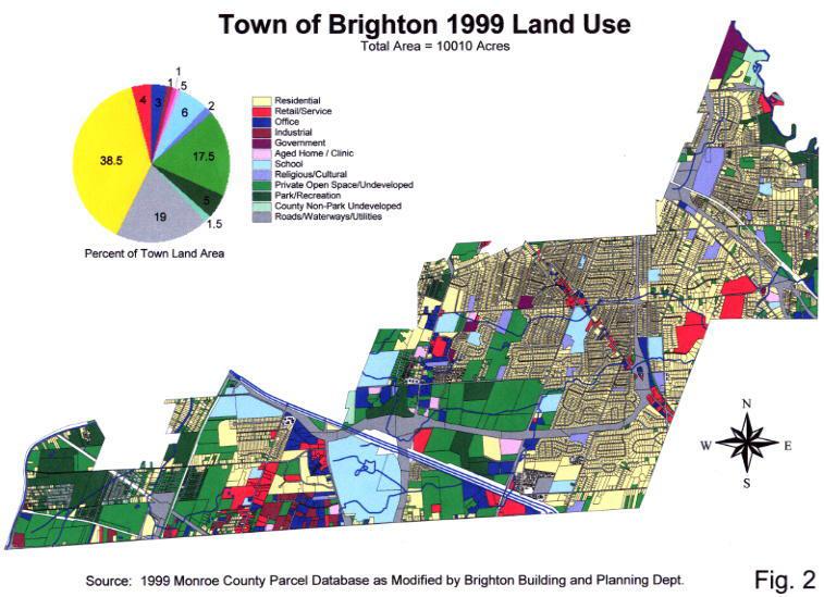
2 feet or greater - all but one of these have been located in office parks at Meridian Centre, Linden Oaks, Canal View, and Corporate Woods. Smaller office projects have been concentrated within the S. Clinton Ave. / Lac De Ville Blvd. corridor. Of the 176 single family residences built, 63 were in the Deerfield Woods subdivision - a compact development project owned by the Rochester Housing Authority and intended to assist moderate income families with home purchases. Thirty-four of the remaining 113 units were in the new Brittany Circle subdivision and 16 were in the Barclay Square subdivision off Westfall Rd. New commercial buildings consisted of Mario s restaurant and an Arby s chain restaurant, both on Monroe Ave.; a Jiffy Lube service station on W. Henrietta Rd.; and the 40,000 SF Cinemark movie theater, also on W. Henrietta Rd. Included in the other category were 2 day care centers and one religious building, but the majority of development in that category consisted of nursing or assisted living facilities for the elderly. A 93,000 SF nursing home was built on lower Lac DeVille Blvd., and construction was begun on two major transitional/assisted living projects: The Summit near Winton Rd. and I- 590, and St. John s cottages and apartments on Elmwood Ave. Development Constraints The approximate distribution of land uses in Brighton is shown in Fig Overall, parcel records indicate that approximately 17.5 percent, or 1750 acres, of Brighton s privately-owned land area remains undeveloped (Fig. 2). About 1000 acres of private undeveloped area is in lots greater than 10 acres. The remaining 750 acres are made up primarily of in-fill lots and small, contiguous lots left undeveloped from older subdivisions. The lots in undeveloped subdivisions constitute greater than 10 acre undeveloped areas when taken together. There are also numerous small, land-locked parcels and lots on Brighton s border with houses located in other municipalities. Most of the privately owned parcels over 10 acres in size and the contiguous, small lots from previous subdivisions are located west of Winton Rd. Vacant land in central Brighton is concentrated in the area bounded by Westfall Rd., Winton Rd., S. Clinton Ave. and Brighton- Henrietta Town Line Rd. This area is composed primarily of large tracts of open space with relatively few wetland, floodplain or woodlot areas, and no steep slopes. It is also attractive for development because of its proximity to the I-590 expressway. The major development constraints on this area are the capacities of the bordering roads, the capacity of sanitary trunk lines in the area and the potential impact of development on surrounding residential neighborhoods. 1 Data from the Monroe County Parcel Database. Some modifications to the Monroe County data were made to address discrepancies between the database and Comprehensive Plan land use designations. Roads/Waterways/Utilities" includes all land not included in other land use categories. Land use distribution figures have been compiled as accurately as possible, but should be considered approximate. 44
3
4 Approximately 350 acres of privately owned undeveloped property in parcels over 10 acres in size are located west of W. Henrietta Rd. There are also several older, undeveloped subdivisions of small lots. This area of Brighton is less amenable for development. At present, sanitary sewers are not available except for the new trunk line on Town Line Rd. Most of the area is served by Crittenden Rd. or East River Rd., both low-volume roads. Much of the area is influenced by the flood plain of Red Creek, the Genesee River, or smaller creeks, and there are numerous state and federal wetlands present. The area east of Winton Rd. is mostly developed. There are three parcels totaling 48 acres that are greater than 10 acres in size and privately owned. Two of these parcels are contiguous and development on them is constrained by woodlots and steep slopes. The third is located north of Browncroft Blvd. and is relatively free of environmental constraints. Issues 1) As the amount of available land decreases, both within Brighton and throughout the county, there is greater demand for those remaining areas that exhibit characteristics that make them attractive for development. What those characteristics are varies among different land uses, but generally, land that is free of environmental and physical constraints, is readily accessible by expressway, is in an attractive setting, and is located near shopping and services is highly desired by developers. With declining availability, interest also increases in the development of lower quality lands (e.g., encumbered by wetlands or other environmental constraints) if several of the above characteristics are present, and in increasing the density or intensity of development on other remaining open lands. 2) Many of the remaining open space areas in Brighton have significant environmental features - streams, flood plains, woodlots, wetlands, steep slopes - over a large portion of the area. Most are also affected by soils that drain poorly, and some lack sanitary sewers. Development of these areas according to the standards permitted by existing zoning regulations, particularly permitted densities, could result in unacceptable damage to these environmental areas that are on or near the development project. 3) The residential character of Brighton could suffer from development that overwhelms the capacity of existing roads. 4) Brighton s volunteer emergency services, fire and ambulance, may struggle to respond to increased demands caused by development. Responses It has been necessary to rethink the premises of earlier land use plans, especially with regard to commercial, office, and industrial location. Yet many of the basic objectives of earlier plans are still valid. Guidelines to direct the location, type, and intensity of new development should include the following: 1) Higher density uses should be channeled to areas where higher traffic volumes can be accommodated and where water and sewer services can readily be provided. 47
5 2) In-fill of development closer to community centers should be encouraged before services are extended into unserviced areas. 2) New residential and non-residential zoning districts and regulations should be developed to increase the protection of significant environmental areas within Brighton s remaining undeveloped lands. Reduced density of development is an important component of this protection strategy. 3) New developments should be located and designed to enhance the neighborhood concept. This includes providing some unifying design elements such as pedestrian circulator systems and contiguous open land linkages. 4) Schools, parks, and other community centers of activity should function as focal points to facilitate social and recreational activity. 5) The preservation of open space, utilizing a combination of available techniques, should continue to be actively pursued in the review of developments and in future public expenditures Land Use Recommendations The land use component of the Comprehensive Plan consists of three parts: the Land Use Supplemental Information (Appendix 2), which provides background and supporting information; Goals and Recommendations that affect land use town-wide (Chapter II); and this, which includes land use recommendations for 39 areas throughout the town. The 39 areas investigated encompass larger, privately owned open spaces town-wide, significant smaller areas of open or partially developed land, and the Monroe Ave. and W. Henrietta Rd. street corridors. The, in concert with the Open Space & Recreation Plan and Community Goals and Strategic & Policy Recommendations, is intended to guide decisions on land use and development proposals that may be presented to the town in the future. Land Use Recommendation Areas are illustrated graphically on the Map (Fig. 3), a 1999 aerial map of the town (Fig. 4), and larger scale aerials of land use recommendation areas (Figs. 5-10). The recommendations are based upon the following: C C Existing conditions. The physical characteristics, existing land uses, infrastructure, and environmental constraints of each of the 39 areas investigated were considered, as were existing traffic patterns. For the large open spaces of south-central Brighton, a traffic study was done to determine the capacity of the street network to support future development. Goals and Strategic & Policy Recommendations adopted by the Comprehensive Plan Steering Committee. In addition to the existing conditions mentioned above, The Steering Committee examined, through the use of focus groups, presentations by town 48
6 C staff and outside experts, and existing documents, other influences on the town s land use. Reports, included in Chapters III through X of the plan, were produced on each of the influences considered. From the information contained in the reports, goals, policies and strategies were developed to address the town s needs (Chapter II). The Open Space & Recreation Plan. The recognizes and reinforces the Open Space & Recreation Plan (Chapter III) by reiterating its recommendations for acquisition, identifying the need for master planned and clustered development in appropriate areas, and establishing new criteria for lot size and density to mitigate some of the impacts of development. Definition of Densities In developing density recommendations, the following factors were taken into consideration: C The density and character of existing development in and around the investigation area and town-wide; C The environmental, physical and infrastructure characteristics of the area; and C The desirability of providing transition between areas with different uses, density and/or character. Residential Densities Large Lot Residential A new zoning district is proposed, Large Lot Residential, which is intended to: mitigate the impacts of development on environmentally sensitive features such as flood plains, steep slopes, watercourses, wetlands or areas with poor drainage; provide adequate space for individual septic systems; and mitigate development impacts on areas with existing semi-rural character. The Large Lot Residential District would permit one single family dwelling per lot. The determination of the minimum lot size permitted by code will be determined after further investigation, however, minimum permitted lot size should be significantly greater than the largest minimum size currently required (23,125 sf in the RLA low density residential district). As used in the, the maximum residential units per acre recommended are: Low Density Residential 4 units per acre Medium Density Residential 6 units per acre Medium/High Density Residential 8 units per acre High Density Residential More than 8 units per acre Relative to existing (yr 2000) regulations, Low Density Residential approximates Residential Low Density C standards. It indicates that either RLA, RLB or RLC zoning densities might be 49
7 appropriate, but does not specify which. Medium Density Residential is the equivalent of Residential Medium Density zoning, Medium/High Density Residential is somewhat less than the density allowed in the Residential High Density RHD-2 district, and High Density Residential corresponds to Residential High Density RHD-1. With the exception of the proposed Large Lot Residential District, recommended densities are not intended to identify types of structures to be permitted (e.g., attached as opposed to detached dwellings). Non-Residential Densities A new office district is proposed, Low Density Office, which is intended to: provide a transition zone between higher intensity commercial, office, or industrial zones and lower intensity residential zones, parkland, or other low intensity uses; limit impacts on traffic and the environment that can accompany higher intensity uses; promote the preservation of existing natural features and habitats; protect sensitive environmental features; aid in preserving the open character of an area; and provide for the establishment of office and service uses at a scale that is compatible with surrounding uses. As with the proposed Large Lot Residential District, the bulk standards for the Low Density Office District will be determined after further investigation, but the following guidelines are recommended: maximum density (building sf per acre) significantly lower than existing 10,000 sf/acre (proposed maximum density of 7,000 sf/acre); minimum lot size at least as much as largest existing office district (largest minimum is 40,000 sf); increased setbacks, particularly from residential uses; maximum permitted impervious coverage significantly lower than existing; and a maximum size (gsf) limit on buildings. With the exception of the proposed Low Density Office District, the assumes nonresidential development at existing maximum permitted densities - 10,000 gross square feet per acre for all districts except Planned Residential Development, Planned Unit Development and Waterfront Development. 50
Appendix A: Guide to Zoning Categories Prince George's County, Maryland
 Appendix A: Guide to Zoning Categories Prince George's County, Maryland RESIDENTIAL ZONES 1 Updated November 2010 R-O-S: Reserved Open Space - Provides for permanent maintenance of certain areas of land
Appendix J - Planned Unit Development (PUD)
") Appendix J - Planned Unit Development (PUD) Intent and Purpose The purpose of the PUD is: 1. To provide development that is consistent with the Comprehensive Land Use Plan and promote the goals and objectives
Appendix J - Planned Unit Development (PUD) Intent and Purpose The purpose of the PUD is: 1. To provide development that is consistent with the Comprehensive Land Use Plan and promote the goals and objectives
CHAPTER Committee Substitute for Committee Substitute for Senate Bill No. 2188
 CHAPTER 2004-372 Committee Substitute for Committee Substitute for Senate Bill No. 2188 An act relating to land development; amending s. 197.502, F.S.; providing for the issuance of an escheatment tax
Planning Department Oconee County, Georgia
 Planning Department Oconee County, Georgia STAFF REPORT REZONE CASE #: 6985 DATE: October 31, 2016 STAFF REPORT BY: Andrew C. Stern, Planner APPLICANT NAME: Williams & Associates, Land Planners PC PROPERTY
LAND USE ASSUMPTIONS REPORT POTENTIAL FUTURE DEVELOPMENT WEST WHITELAND TOWNSHIP, CHESTER COUNTY, PA
 LAND USE ASSUMPTIONS REPORT POTENTIAL FUTURE DEVELOPMENT WEST WHITELAND TOWNSHIP, CHESTER COUNTY, PA Adopted June 17, 2015 by Township Resolution No. 2015-30 Prepared by Theurkauf Design & Planning, LLC
2014 Plan of Conservation and Development. Development Plan & Policies
 The Town of Hebron Section 3 2014 Plan of Conservation and Development Development Plan & Policies C. Residential Districts I. Residential Land Analysis This section of the plan uses the land use and vacant
Land Use. Land Use Categories. Chart 5.1. Nepeuskun Existing Land Use Inventory. Overview
 Land Use State Comprehensive Planning Requirements for this Chapter A compilation of objectives, policies, goals, maps and programs to guide the future development and redevelopment of public and private
FUTURE LAND USE. City of St. Augustine Comprehensive Plan EAR-Based Amendments
 FUTURE LAND USE City of St. Augustine Comprehensive Plan EAR-Based Amendments Future Land Use Element FLU Goal To create an environment within the City and adjacent areas in which its residents have the
Cover Letter with Narrative Statement
 Cover Letter with Narrative Statement March 31, 2017 rev July 27, 2017 RE: Rushton Pointe Residential Planned Unit Development Application for Public Hearing for RPUD Rezone PL2015 000 0306 Mr. Eric Johnson,
Chapter Planned Residential Development Overlay
 Chapter 19.29 Planned Residential Development Overlay Sections 010 Purpose 020 Scope 030 Definitions 030 Minimum Size 040 Allowable Uses 050 Minimum Development Standards 060 Density Bonus 070 Open Space
Staff Report. Planning Commission Public Hearing: October 17, 2007 Staff Recommendation: Denial
 COUNTY OF PRINCE WILLIAM 5 County Complex Court, Prince William, Virginia 22192-9201 PLANNING (703) 792-6830 Metro 631-1703, Ext. 6830 FAX (703) 792-4401 OFFICE Internet www.pwcgov.org Stephen K. Griffin,
L. LAND USE. Page L-1
 L. LAND USE 1. Purpose This section discusses current and likely future land use patterns in Orland. An understanding of land use trends is very important in determining Orland's ability to absorb future
8Land Use. The Land Use Plan consists of the following elements:
 8Land Use 1. Introduction The Land Use Plan consists of the following elements: 1. Introduction 2. Existing Conditions 3. Opportunities for Redevelopment 4. Land Use Projections 5. Future Land Use Policies
Chapter 5: Testing the Vision. Where is residential growth most likely to occur in the District? Chapter 5: Testing the Vision
 Chapter 5: Testing the Vision The East Anchorage Vision, and the subsequent strategies and actions set forth by the Plan are not merely conceptual. They are based on critical analyses that considered how
Rule 80. Preservation of Primary Agricultural Soils Revised and approved by the Land Use Panel during its public meeting on January 31, 2006.
 Rule 80. Preservation of Primary Agricultural Soils Revised and approved by the Land Use Panel during its public meeting on January 31, 2006. (A) Purpose. In accordance with 10 V.S.A. Sections 6025(b)
In order to permit maximum applicability of the PUD District, PUD-1 and PUD-2 Districts are hereby created.
 ARTICLE III. PUD ned Unit Development Overlay District 205-128. Purpose. The PUD ned Unit Development Overlay District is intended to provide flexibility in the design of planned projects; to encourage
PIN , Part 1, Plan SR-713 in Lot 2, Concession 5, Township of McKim (1096 Dublin Street, Sudbury)
") STAFF REPORT Applicant: Dalron Construction Limited Location: PIN 02124-0103, Part 1, Plan SR-713 in Lot 2, Concession 5, Township of McKim (1096 Dublin Street, Sudbury) Official Plan and Zoning By-law:
STAFF REPORT Applicant: Dalron Construction Limited Location: PIN 02124-0103, Part 1, Plan SR-713 in Lot 2, Concession 5, Township of McKim (1096 Dublin Street, Sudbury) Official Plan and Zoning By-law:
CHAPTER 2 VACANT AND REDEVELOPABLE LAND INVENTORY
 CHAPTER 2 VACANT AND REDEVELOPABLE LAND INVENTORY CHAPTER 2: VACANT AND REDEVELOPABLE LAND INVENTORY INTRODUCTION One of the initial tasks of the Regional Land Use Study was to evaluate whether there is
Comprehensive Plan 2030
 Introduction Land use, both existing and future, is the central element of a Comprehensive Plan. Previous chapters have discussed: Projected population growth. The quality housing available in the Township
SECTION 3. Housing. Appendix A LAND USE DEFINITIONS
 SECTION 3 Housing A Appendix A LAND USE DEFINITIONS A-2 Housing Commission Attachment B Appendix A Land Use Definitions INTRODUCTION The Land Use Map (Figure A-1) of Community Vision 2040 illustrates the
2030 General Plan. December 6, 7 pm
 2030 General Plan GPAC Meeting #9 GPAC Meeting #9 December 6, 7 pm City Council Input on Working Draft Land Use Map Council discussed GPAC & PC versions of the working draft land use map 11/28 Council
Article Floating Zone Requirements
 Division 5.1. In General Article 59-5. Floating Zone Requirements Section 5.1.1. Zone Categories There are 4 categories of Floating zones: A. Residential Floating zones (Division 5.2); B. Commercial/Residential
GENERAL DESCRIPTION STAFF RECOMMENDATION IMPLEMENTATION REQUIREMENTS
 Application No.: 891418 Applicant: AREA-WIDE MAP AMENDMENT Rezone two parcels from Moderate Density Single Family (MSF) to Neighborhood Center (NC) and Employment Center (EC). Charles Bitton GENERAL DESCRIPTION
HOOD RIVER COUNTY EXCEPTIONS DOCUMENT. (Amended 12/17/84)
") HOOD RIVER COUNTY EXCEPTIONS DOCUMENT 1984 (Amended 12/17/84) COUNTY EXCEPTIONS DOCUMENT The Hood River County Comprehensive Land Use Plan is the basic instrument used for County land use planning. It
HOOD RIVER COUNTY EXCEPTIONS DOCUMENT 1984 (Amended 12/17/84) COUNTY EXCEPTIONS DOCUMENT The Hood River County Comprehensive Land Use Plan is the basic instrument used for County land use planning. It
ARTICLE III: DENSITY AND INTENSITY
 ARTICLE III: DENSITY AND INTENSITY Section 18.301: Purpose The purpose of this Article is to indicate the maximum permitted density (for residential projects) and maximum permitted intensity (for nonresidential
FINAL DRAFT 12/1/16, Rev. to 7/18/17
 FINAL DRAFT 12/1/16, Rev. to 7/18/17 (As Adopted 8/8/17 Effective 9/1/17) SHELTON PLANNING AND ZONING COMMISSION Proposed Amendments to Zoning Regulations I. Amend Section 23 PERMITTED USES by inserting
STAFF REPORT. Permit Number: Laurier Enterprises, Inc. Kitsap County Board of Commissioners; Kitsap County Planning Commission
 STAFF REPORT Permit Number: 15 00740 Laurier Enterprises, Inc. DATE: November 9, 2015 TO: FROM: Kitsap County Board of Commissioners; Kitsap County Planning Commission Katrina Knutson, AICP, Senior Planner,
STAFF REPORT. Permit Number: Laurier Enterprises, Inc. Kitsap County Board of Commissioners; Kitsap County Planning Commission
 STAFF REPORT Permit Number: 15 00740 Laurier Enterprises, Inc. DATE: December 18, 2015 TO: FROM: Kitsap County Board of Commissioners; Kitsap County Planning Commission Katrina Knutson, AICP, Senior Planner,
City of Spokane Infill Development. June 30, 2016
 City of Spokane Infill Development June 30, 2016 Today s Agenda Introductions Background and Adopted Policy Infill Forms: Facilitated Group Discussion Small-Group Discussions Groups Report Out Next Steps
Business Item Community Development Committee Item:
 Business Item Community Development Committee Item: 2008-124 C Meeting date: July 21, 2008 ADVISORY INFORMATION Date: May 21, 2008 Subject: Flexible Residential Development Ordinance Guidelines District(s),
Comprehensive Plan Amendment #PLN , Reserve at Cannon Branch (Coles Magisterial District)
") COUNTY OF PRINCE WILLIAM 5 County Complex Court, Prince William, Virginia 22192-9201 PLANNING (703) 792-7615 FAX (703) 792-4758 OFFICE Internet www.pwcgov.org Christopher M. Price, AICP Director of Planning
COUNTY OF PRINCE WILLIAM 5 County Complex Court, Prince William, Virginia 22192-9201 PLANNING (703) 792-7615 FAX (703) 792-4758 OFFICE Internet www.pwcgov.org Christopher M. Price, AICP Director of Planning
Community Development
 Land Use Petition RZ-16-002 Date of Staff Recommendation Preparation: April 15, 2016 (CEL) Date of Planning Commission Recommendation: May 3, 2016 PROJECT LOCATION: DISTRICT/SECTION/LANDLOT(S): ACREAGE
Open Space Model Ordinance
 Open Space Model Ordinance Section I. Background Open space development has numerous environmental and community benefits, including: 1) Reduces the impervious cover in a development. Impervious cover
Generic Environmental Impact Statement. Build-Out Analysis. City of Buffalo, New York. Prepared by:
 Generic Environmental Impact Statement Build-Out Analysis City of Buffalo, New York 2015 Prepared by: TABLE OF CONTENTS 1.0 INTRODUCTION 1 2.0 METHODOLOGY 2 3.0 EXISTING LAND USE 3 4.0 EXISTING ZONING
STAFF REPORT. Permit Number: Lee. Kitsap County Board of Commissioners; Kitsap County Planning Commission
 STAFF REPORT Permit Number: 15 00689 Lee DATE: March 2, 2016 TO: FROM: Kitsap County Board of Commissioners; Kitsap County Planning Commission Katrina Knutson, AICP, Senior Planner, DCD and Jeff Arango,
TASK 2 INITIAL REVIEW AND ANALYSIS U.S. 301/GALL BOULEVARD CORRIDOR FORM-BASED CODE
 TASK 2 INITIAL REVIEW AND ANALYSIS U.S. 301/GALL BOULEVARD CORRIDOR FORM-BASED CODE INTRODUCTION Using the framework established by the U.S. 301/Gall Boulevard Corridor Regulating Plan (Regulating Plan),
Be linked by an internal circulation system (i.e., walkways, streets, etc.) to other structures within the IPUD;
 to other structures within the IPUD;") 2. HALIFAX ACTIVITY CENTER A. DESCRIPTIONS OF FUTURE LAND USE DESIGNATIONS Each of the future land use designations specified by Phase I of the Halifax Activity Center Plan, and the relationship of these
2. HALIFAX ACTIVITY CENTER A. DESCRIPTIONS OF FUTURE LAND USE DESIGNATIONS Each of the future land use designations specified by Phase I of the Halifax Activity Center Plan, and the relationship of these
REZONING GUIDE. Zone Map Amendment (Rezoning) - Application. Rezoning Application Page 1 of 3. Return completed form to
 - Application. Rezoning Application Page 1 of 3. Return completed form to") Zone Map Amendment (Rezoning) - Application COMMUNITY PLANNING & DEVELOPMENT REZONING GUIDE Rezoning Application Page 1 of 3 PROPERTY OWNER INFORMATION* CHECK IF POINT OF CONTACT FOR APPLICATION Property
Zone Map Amendment (Rezoning) - Application COMMUNITY PLANNING & DEVELOPMENT REZONING GUIDE Rezoning Application Page 1 of 3 PROPERTY OWNER INFORMATION* CHECK IF POINT OF CONTACT FOR APPLICATION Property
City of Sanibel. Planning Department STAFF REPORT
 City of Sanibel Planning Department STAFF REPORT Planning Commission Meeting: July 23, 2013 Planning Commission Agenda Item: No 7b. Application Number: 13-7438DP Applicant Name: Attorney Beverly Grady
610 LAND DIVISIONS AND PROPERTY LINE ADJUSTMENTS OUTSIDE A UGB
 ARTICLE VI: LAND DIVISIONS AND PROPERTY LINE ADJUSTMENTS VI-21 610 LAND DIVISIONS AND PROPERTY LINE ADJUSTMENTS OUTSIDE A UGB 610-1 Property Line Adjustments (Property Line Relocation) A property line
CHAPTER 3 PRELIMINARY PLAT
 10-3-1 10-3-3 SECTION: CHAPTER 3 PRELIMINARY PLAT 10-3-1: Consultation 10-3-2: Filing 10-3-3: Requirements 10-3-4: Approval 10-3-5: Time Limitation 10-3-6: Grading Limitation 10-3-1: CONSULTATION: Each
SUBCHAPTER 23-3: DENSITY AND INTENSITY REGULATIONS
 SUBCHAPTER 23-3: DENSITY AND INTENSITY REGULATIONS Section 23.301 Purpose The purpose of this Subchapter is to indicate the maximum permitted density (for residential projects) and maximum permitted intensity
TREASURE COAST REGIONAL PLANNING COUNCIL M E M O R A N D U M
 TREASURE COAST REGIONAL PLANNING COUNCIL M E M O R A N D U M To: Council Members AGENDA ITEM 5F From: Date: Subject: Staff July 16, 2010 Council Meeting Local Government Comprehensive Plan Review Draft
ADMINISTRATIVE REPORT
 ADMINISTRATIVE REPORT TO: FROM: Advisory Planning Commission B. Newell, Chief Administrative Officer DATE: February 14, 2017 RE: OCP & Zoning Bylaw Amendment Electoral Area D Purpose: To facilitate a residential
Highland Green Estates Neighbourhood Area Structure Plan
 Highland Green Estates Neighbourhood Area Structure Plan Original Outline Plan approved by Council: March 10, 1997 Outline Plan amended by Council: March 24, 1997 Converted to a Neighbourhood Area Structure
BUILD-OUT ANALYSIS GRANTHAM, NEW HAMPSHIRE
 BUILD-OUT ANALYSIS GRANTHAM, NEW HAMPSHIRE A Determination of the Maximum Amount of Future Residential Development Possible Under Current Land Use Regulations Prepared for the Town of Grantham by Upper
Georgia Conservation Tax Credit Program Frequently Asked Questions
 Georgia Conservation Tax Credit Program Frequently Asked Questions What are the minimum requirements for eligibility under the Georgia Conservation Tax Credit Program (GCTCP)? Individual and corporate
Article 7: Residential Land Use and Development Requirements
 Article 7: Residential Land Use and Section 701: Statement of Intent (A) (B) (C) The intent of Article 7 is to develop certain land use and development requirements for the residential uses within Cumru
ZONING CLASSIFICATION SUMMARY SHEET
 Growth and Resource Management Planning and Development Services 123 West Indiana Avenue Room 202 DeLand, Florida 32720-4253 Telephone (386) 943-7059 Fax (386) 626-6570 www.volusia.org ZONING CLASSIFICATION
10.2 ALBION AREA PLAN
 10.2 ALBION AREA PLAN Maple Ridge Official Community Plan Bylaw No. 7060-2014 Chapter 10, Page 5 10.2 ALBION AREA PLAN The following policies are adopted to guide development within the Albion urban area.
Zoning and Subdivision Ordinances Public Hearing
 Zoning and Subdivision Ordinances Public Hearing June 14, 2007 Kise Straw & Kolodner Public Process Begun in September 2004 Comprehensive Plan (June 2006) Zoning Ordinance SALDO Comprehensive Plan Committee
LONG-RANGE LAND USE PLAN
 LONG-RANGE LAND USE PLAN INTENT Completion of the I-66/Route 29 interchange and future expansion of improved telecommunication networks will substantially improve the desirability of the Gainesville area
Article 3 - Rural Districts
 rticle 3 - Rural Districts Div. 3.1. -40: griculture 40 (OI Only) 3-2 3.1.1. Intent... 3-2 3.1.2. Lot Dimensions... 3-2 3.1.3. uilding Placement... 3-3 3.1.4. uilding Height... 3-3 Div. 3.2. -20: griculture
CITY PLANNING COMMISSION COMPREHENSIVE PLAN AND REVIEW CRITERIA
 Page 3 CITY PLANNING COMMISSION COMPREHENSIVE PLAN AND REVIEW CRITERIA COMPREHENSIVE PLAN: The City Planning Commission uses the Comprehensive Plan as a guide in all land use matters. The Plan is available
Planning & Development. Background. Subject Properties
 Planning & Development APPLICATION BRIEFING Prepared For: Planning Advisory Committee Submitted by: Jason Fox, Director of Planning & Development Date: Subject: Application by Meech Holdings Limited to
Paul D. Ralph, BES, RPP, MCIP, Commissioner, Development Services Department
 Public Report To: From: Report Number: Development Services Committee Paul D. Ralph, BES, RPP, MCIP, Commissioner, Development Services Department DS-16-50 Date of Report: April 14, 2016 Date of Meeting:
Town of. River Falls. Land Use Element Vierbicher Associates, Inc
 Town of River Falls 2005 Vierbicher Associates, Inc Contents Contents s. 66.1001(2)(h) Wis. Stats................................................. ii Introduction................................................................
REPORT OF THE PLANNING AND DEVELOPMENT DEPARTMENT FOR APPLICATION FOR REZONING ORDINANCE TO PLANNED UNIT DEVELOPMENT APRIL 21, 2016
 BEL REPORT OF THE PLANNING AND DEVELOPMENT DEPARTMENT FOR APPLICATION FOR REZONING ORDINANCE TO PLANNED UNIT DEVELOPMENT APRIL 21, 2016 The Planning and Development Department hereby forwards to the Planning
ARTICLE I ZONE BASED REGULATIONS
 ARTICLE I ZONE BASED REGULATIONS RZC 21.08 RESIDENTIAL REGULATIONS 21.08.290 Cottage Housing Developments A. Purpose. The purpose of the cottage housing requirements is to: 1. Provide a housing type that
Land Use Planning Analysis. Phase 2 Drayton Valley Annexation Proposal
 Land Use Planning Analysis Phase 2 Drayton Valley Annexation Proposal Prepared for Town of Drayton Valley Prepared by Mackenzie Associates Consulting Group Limited March, 2011 TABLE OF CONTENTS 1.0 INTRODUCTION...
STAFF REPORT. Permit Number: Unlimited. Kitsap County Board of Commissioners; Kitsap County Planning Commission
 STAFF REPORT Permit Number: 15 00550 Unlimited DATE: March 2, 2016 TO: FROM: Kitsap County Board of Commissioners; Kitsap County Planning Commission Katrina Knutson, AICP, Senior Planner, DCD and Jeff
STAFF REPORT. Permit History:
 STAFF REPORT Application: Request to rezone property from General Agriculture (AG) to Suburban Residential (a) (R-2a) Applicant: Perry Puncochar Agenda Item: 4(g) Background Information: Proposal: The
ARTICLE 3: Zone Districts
 ARTICLE 3: Zone Districts... 3-1 17.3.1: General...3-1 17.3.1.1: Purpose and Intent... 3-1 17.3.2: Districts and Maps...3-1 17.3.2.1: Applicability... 3-1 17.3.2.2: Creation of Districts... 3-1 17.3.2.3:
PROPOSED AMENDMENTS TO THE DERBY ZONING REGULATIONS AUGUST 12, 2008
 ARTICLE II Definitions and word usage 195-7. Definitions and word usage. Modify the following: HOUSING FOR THE ELDERLY OLDER PERSONS Housing in accordance with and as defined in the United States Fair
Chapter 10: Implementation
 Chapter 10: Introduction Once the Comprehensive Plan has been adopted by the City of Oakdale, the City can begin to implement the goals and strategies to make this vision a reality. This chapter will set
Table of Contents. Appendix...22
 Table Contents 1. Background 3 1.1 Purpose.3 1.2 Data Sources 3 1.3 Data Aggregation...4 1.4 Principles Methodology.. 5 2. Existing Population, Dwelling Units and Employment 6 2.1 Population.6 2.1.1 Distribution
TOTTENHAM SECONDARY PLAN
 TOTTENHAM SECONDARY PLAN AMENDMENT NO. 11 TO THE OFFICIAL PLAN OF THE TOWN OF NEW TECUMSETH The following text and schedules to the Official Plan of the Town of New Tecumseth constitute Amendment No. 11
If projects are received at the counter to be submitted without prior draft review, the project will be deferred to the next meeting.
 5400 Butternut Drive East Syracuse, NY13057-8509 Phone: 315.446.3910 x3 Fax: 315.449.0620 Edward M.Michalenko, PhD. Supervisor Planning & Zoning Samuel C. Gordon, MLA, Director Welcome to the Town of DeWitt
STAFF REPORT. Permit Number: Porter. Kitsap County Board of Commissioners; Kitsap County Planning Commission
 STAFF REPORT Permit Number: 15 00461 Porter DATE: November 9, 2015 TO: FROM: Kitsap County Board of Commissioners; Kitsap County Planning Commission Katrina Knutson, AICP, Senior Planner, DCD and Jeff
MONTGOMERY COUNTY PLANNING DEPARTMENT THE MARYLAND-NATIONAL CAPITAL PARK AND PLANNING COMMISSION
 MONTGOMERY COUNTY PLANNING DEPARTMENT THE MARYLAND-NATIONAL CAPITAL PARK AND PLANNING COMMISSION MCPB Item No. 3 Date: 01-31-13 Preliminary Plan 120090300, Boyds Highlands Calvin Nelson, Jr. Planner Coordinator,
3.1. OBJECTIVES FOR RESIDENTIAL LAND USE DESIGNATIONS GENERAL OBJECTIVES FOR ALL RESIDENTIAL DESIGNATIONS
 3. RESIDENTIAL LAND USE DESIGNATIONS INTRODUCTION The Residential land use designations provide for housing and other land uses that are integral to, and supportive of, a residential environment. Housing
Article Optional Method Requirements
 Article 59-6. Optional Method Requirements [DIV. 6.1. MPDU DEVELOPMENT IN RURAL RESIDENTIAL AND RESIDENTIAL ZONES Sec. 6.1.1. General Requirements... 6 2 Sec. 6.1.2. General Site and Building Type Mix...
HOUSING ELEMENT GOALS, OBJECTIVES, AND POLICIES
 HOUSING ELEMENT GOALS, OBJECTIVES, AND POLICIES GOAL 1: To promote the preservation and development of high-quality, balanced, and diverse housing options for persons of all income levels throughout the
I. Requirements for All Applications. C D W
 108-16.1. Application checklists. Checklist for Required Submissions to the Planning Board or Zoning Board of Adjustment of Monroe Township All required submissions are to be made to the Administrative
United States Post Office and Multi-Family Residential; and, Single- Family Residence with an Apartment
 Planning Commission File No.: AME2013 0009 January 9, 2014 Page 2 of 9 Existing Land Use: United States Post Office and Multi-Family Residential; and, Single- Family Residence with an Apartment Surrounding
PLANNED UNIT DEVELOPMENTS (Ordinance No.: 3036, 12/3/07; Repealed & Replaced by Ordinance No.: 4166, 10/15/12)
") 159.62 PLANNED UNIT DEVELOPMENTS (Ordinance No.: 3036, 12/3/07; Repealed & Replaced by Ordinance No.: 4166, 10/15/12) A. PURPOSE 1. General. The Planned Unit Development (PUD) approach provides the flexibility
159.62 PLANNED UNIT DEVELOPMENTS (Ordinance No.: 3036, 12/3/07; Repealed & Replaced by Ordinance No.: 4166, 10/15/12) A. PURPOSE 1. General. The Planned Unit Development (PUD) approach provides the flexibility
Nassau County Department of Planning & Economic Opportunity Nassau Place Yulee, Florida 32097
 Nassau County Department of Planning & Economic Opportunity 96161 Nassau Place Yulee, Florida 32097 APPLICATION AND INSTRUCTIONS FOR FUTURE LAND USE MAP AMENDMENT (TEN (10) ACRES OR MORE) NOTICE: Florida
ARLINGTON COUNTY, VIRGINIA. County Board Agenda Item Meeting of June 17, 2017
 ARLINGTON COUNTY, VIRGINIA County Board Agenda Item Meeting of June 17, 2017 DATE: June 9, 2017 SUBJECT: Request to authorize advertisement of public hearings by the Planning Commission and County Board
Residential Project Convenience Facilities
 Standards for Specific Land Uses 35.42.220 E. Findings. The review authority shall approve a Land Use Permit in compliance with Subsection 35.82.110.E (Findings required for approval) or a Conditional
LAND USE. As such, the Township has estasblished the following statement of objectives for future development within its borders:
 LAND USE When creating a land use plan, a municipality should consider a process which firsts determines future population figures, whether growth or decline, and its targeted areas within the municipal
STAFF REPORT PLN September 11, 2017
 Page: 1 TO: SUBJECT: GENERAL COMMITTEE APPLICATIONS FOR OFFICIAL PLAN AMENDMENT AND ZONING BY-LAW AMENDMENT 37 JOHNSON STREET WARD: WARD 1 PREPARED BY AND KEY CONTACT: SUBMITTED BY: GENERAL MANAGER APPROVAL:
Chapter 6 Future Land Use and Housing Plan
 Chapter 6 Future Land Use and Housing Plan The Future Land Use Plan is one of the most important elements of the Comprehensive Plan. It graphically brings together all of the chapters of the plan and evaluates
TOWNSHIP OF EGG HARBOR ZONING BOARD ADJUSTMENT CHECK LIST
 TOWNSHIP OF EGG HARBOR ZONING BOARD ADJUSTMENT CHECK LIST Schedule A - General Requirements 1. Where the application involves only a variance one (1) original and nineteen (19) copies of the appropriate
Residential Neighborhoods and Housing
 Residential Neighborhoods and Housing 3 GOAL - To protect Greenwich as a predominantly residential community and provide for a variety of housing options The migration of businesses and jobs from New York
Letter of Intent May 2017 (Revised November 2017)
") THE BEACH AT WOODMOOR LETTER OF INTENT MAY 2017 (REVISED NOVEMBER 2017) OWNER/APPLICANT: CONSULTANT: Lake Woodmoor Holdings LLC N.E.S. Inc. 1755 Telstar Drive, Suite 211 619 North Cascade Avenue Colorado
THE BEACH AT WOODMOOR LETTER OF INTENT MAY 2017 (REVISED NOVEMBER 2017) OWNER/APPLICANT: CONSULTANT: Lake Woodmoor Holdings LLC N.E.S. Inc. 1755 Telstar Drive, Suite 211 619 North Cascade Avenue Colorado
City of Grande Prairie Development Services Department
 City of Grande Prairie Development Services Department COUNTRYSIDE SOUTH OUTLINE PLAN Prepared by: GPEC Consulting Ltd. #202, 10712-100th Street Grande Prairie, AB Council Resolution of August 20, 2001
4. facilitate the construction of streets, utilities and public services in a more economical and efficient manner;
 PVPC MODEL BYLAW BY-RIGHT CLUSTER ZONING BYLAW Prepared by Pioneer Valley Planning Commission Revised: October 2001 1.00 Development 1.01 Development Allowed By Right Development in accordance with this
4.0. Residential. 4.1 Context
 4. 0Residential 4.1 Context In 1986, around the time of Burnaby s last Official Community Plan, the City had a population of 145,000 living in 58,300 residential units. By 1996, there were 179,000 people
Indicates Council-recommended changes Introduced by: Mr. Tackett Date of introduction: June 14, 2016 SUBSTITUTE NO. 1 TO ORDINANCE NO.
 Indicates Council-recommended changes Introduced by: Mr. Tackett Date of introduction: June 14, 2016 SUBSTITUTE NO. 1 TO ORDINANCE NO. 16-067 TO AMEND NEW CASTLE COUNTY CODE CHAPTER 40 (ALSO KNOWN AS THE
Downtown Development Focus Area: I. Existing Conditions
 Downtown Development Focus Area: I. Existing Conditions The Downtown Development Focus Area is situated along Route 1, south of the train tracks, except for the existing Unilever property. It extends west
Housing & Residential Intensification Study Discussion Paper Township of King
 Housing & Residential Intensification Study Discussion Paper Prepared by Planning Department January 2011 1.0 Background 1.1 Provincial Policies (Greenbelt and Growth Plan) Since 2001, the Province of
MODERATE-INCOME HOUSING BIENNIAL REPORT
 MODERATE-INCOME HOUSING BIENNIAL REPORT Utah Code Section 10-9a-408 requires the legislative body of a municipality to perform a biennial report on moderate-income housing in its community. The following
Land Use Survey Summer 2014
 Land Use Survey Summer 2014 North Ogden City, Utah Robert Scott, City Planner Travis Lund, Planning Intern Contents General Information... 1 Land Use Groups... 1 Urbanized Land Uses... 1 Residential...
For Vintages of Four Mile Creek Town of Niagara on the Lake, Ontario
 Planning Impact Analysis For Vintages of Four Mile Creek Town of Niagara on the Lake, Ontario Prepared by: Upper Canada Consultants 261 Martindale Road Unit #1 St. Catharines, Ontario L2W 1A1 Prepared
REZONING GUIDE. Zone Map Amendment (Rezoning) - Application. Rezoning Application Page 1 of 3. Return completed form to
 - Application. Rezoning Application Page 1 of 3. Return completed form to") COMMUNITY PLANNING & DEVELOPMENT REZONING GUIDE Rezoning Application Page 1 of 3 Zone Map Amendment (Rezoning) - Application PROPERTY OWNER INFORMATION* PROPERTY OWNER(S) REPRESENTATIVE** CHECK IF POINT
COMMUNITY PLANNING & DEVELOPMENT REZONING GUIDE Rezoning Application Page 1 of 3 Zone Map Amendment (Rezoning) - Application PROPERTY OWNER INFORMATION* PROPERTY OWNER(S) REPRESENTATIVE** CHECK IF POINT
CITRUS HEIGHTS COMMUNITY SPECIAL PLANNING AREA
 CITRUS HEIGHTS COMMUNITY SPECIAL PLANNING AREA 501-90. INTENT. It is the intent of the Board of Supervisors in adopting this Special Planning Area Ordinance to allow development on the property described
Section 7.22: Multifamily Assisted Housing in AA-30 Residential Zone (MAHZ) [Note: an additional line will be added to the Table in Article 3, 3.1.
 [Note: an additional line will be added to the Table in Article 3, 3.1.") Section 7.22: Multifamily Assisted Housing in AA-30 Residential Zone (MAHZ) [Note: an additional line will be added to the Table in Article 3, 3.1.1A] 7.22.1 Purpose The purpose of this Special Regulation
Section 7.22: Multifamily Assisted Housing in AA-30 Residential Zone (MAHZ) [Note: an additional line will be added to the Table in Article 3, 3.1.1A] 7.22.1 Purpose The purpose of this Special Regulation
Division 8 General Urban (T4) Zone: Assessment Criteria and Assessment Tables
 Zone: Assessment Criteria and Assessment Tables") Division 8 General Urban (T4) Zone: Assessment Criteria and Assessment Tables 15.8.1 General Urban (T4) Zone The provisions in this division relate to the General Urban (T4) Zone as follows overall outcomes
Division 8 General Urban (T4) Zone: Assessment Criteria and Assessment Tables 15.8.1 General Urban (T4) Zone The provisions in this division relate to the General Urban (T4) Zone as follows overall outcomes
2.2.2 The Land Use Setting
 2-6 Planning Area pearance varies dramatically from season to season. The absence of significant topographic or man-made features within the District contributes to a very open visual character that allows
WHEREAS, the staff of The Maryland-National Capital Park and Planning Commission recommended APPROVAL of the application with conditions; and
 R E S O L U T I O N WHEREAS, Redeemed Christian Church of God is the owner of a 2.83-acre parcel of land known as Lot 9, Lot 19, P/O Lot 1 and P/O Lot 18, Block B, Plat Book A, Plat 5, said property being