The (Legal) Reliability of the Cadastre from the Perspective of the Czech Republic. Mgr. Martina Hercegová Ing. Karel Štencel
|
|
|
- Mercy Sharp
- 5 years ago
- Views:
Transcription
1 The (Legal) Reliability of the Cadastre from the Perspective of the Czech Republic Mgr. Martina Hercegová Ing. Karel Štencel PCC - Conference Vienna

2 Basic information about the CR Area: 78,866 km 2 Population: 10 mil. Administrative division: 14 regions 22 mil parcels 13,094 cadastral units


3 Land Administration System Till 1993 Separated model Cadaster Registration of rights After the re-establishment of democracy in 1989 Merge model (from 1993)


4 Land Records Fiscal Cadastre Topographic Mapping

5 Principle of Material Publicity New Civil Code Act. Nr. 89/2012 Coll. (NCC) Material Publicity what is written is given

6 Digital Cadastral Maps in the Czech Republic PCC - Vienna Stránka 6

7 Digital Cadastral Map Digital Cadastral Maps in the Czech Republic Stránka Page 7
8 Two Basic Types of Maps 1. Maps Based on Original Measurement New maps produced within last 70 years 1/3 area CR Current coordinate system, homogenous, accuracy 14 cm Results of original measurement coordinates calculation, later coordinates saved in register No technical problems, only a lot of work, high quality result
9 Two Basic Types of Maps 2. Maps Based on Stable Cadastre Originate from 1st half of 19th century Different coordinate system, fathom scale, graphical triangulation main reason of partial deformations, accuracy? m Different methods of updating within 150 years source of many technical problems Digitalization mainly by vectorization of raster images of cadastral maps

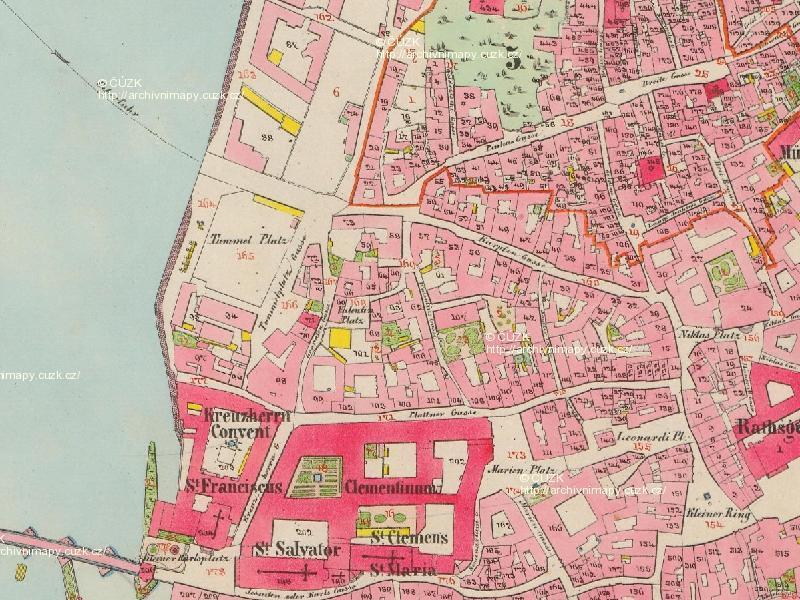
10 Map of Stable Cadastre Prague, Page 10

11 Digital Cadastral Maps in the Czech Republic Using the results of measurement of changes to improve the precesion of map during digitization and subsequent updating

12 4. Technologie přepracování sáhových map 4. Transformace rastrových obrazů map do S-JTSK Přehled identických bodů Porovnání výsledků transformace s ortofotomapou Detekce výsledků zeměměřických činností s chybným polohovým určením PCC - Vienna Stránka 12

13 Digital Cadastral Map + ortophoto PCC - Vienna Stránka 13

14 Digital Cadastral Map PCC - Vienna Stránka 14
15 Refinement of Maps during their updates Owners have the opportunity to review the quality of geodetic cadastral data and then refine these data For refinement (improvement of the accuracy) of the boundaries, it is necessary to submit: Survey Plan Document signed by all the owners that they agree with the refinement of boundaries
16
17 Refinement of Maps during their updates Document signed by all the owners that they agree with the refinement of boundaries (agreement) = the ownership boundary is marked in the cadastral map =>
18 Refinement of Maps during their updates Without the owner's agreement, the original boundary remains unchanged in the map =>
19 Activities of the Cadastral Offices till 2030 Long term Conceptual Document 2017 The most important issues: 1. Insufficient geometric quality of cadastral maps 2. Discrepancies between registered data and actual status in terrain caused by non-compliance with reporting obligations of the owners 3. Out-of-date technical data already registered (in particular data on land types, land use, type and mode of property protection)
20 Increasing the Geometric Quality of Cadastral Maps Completion of digitization does not solve the problem of insufficient cadastral map accuracy in approximately 60% of Cadastral Units We will devote a part of the capacities to the works that will lead to the improvement of Cadastral Maps New Mapping The problem of geometric quality of Cadastral Maps is solvable within next years
21 Process of New Mapping - Phases Project Preparatory Work Investigation of Boundaries Detailed Survey Creating of new Cadastral Documentation Presentation of Results to Owners (Public Consultation) Solving Objections Declaration of Effect of Renewed Cadastral Documentation
22 New Mapping Number of renewed cadastral units

23 Investigation of Boundaries


24 Detailed Survey - Used Technologies New mapping mostly combination of GNSS and terrestrial methods Exploring the use of new technologies (laser scanning, super-precise ortophoto)


25 Presentation of Results to Owners The new cadastral documentation is presented on web
26 Declaration of Effect of Renewed Cadastral Documentation The new mapping is completed by Declaration of Effect of Renewed Cadastral Documentation
27 Results We improve quality of cadastral data for better use in multi-purpose geospatial information systems We want to use digitalized maps for many years and refine them on the basis of Survey Plans Some Cadastral Units will be necessary to map newly (150 cadastral units yearly)
28 Thank you for your attention.
New Cadastral Mapping in the Czech Republic
 New Cadastral Mapping in the Czech Republic Karel Štencel, Svatava Dokoupilová, Jan Kmínek Czech Office for Surveying, Mapping and Cadastre Basic Data about the Czech Republic Area: 78 866 km 2 Population:
Tradition and Innovation in Czech Cadastre. Karel Večeře Martina Hercegová Jan Kmínek Czech Office for Surveying, Mapping and Cadastre
 Tradition and Innovation in Czech Cadastre Karel Večeře Martina Hercegová Jan Kmínek Czech Office for Surveying, Mapping and Cadastre Land Registration and Cadastre History 13 th cent. Land Tables - predecessor
Refinement of Cadastral Maps
 Acta Montanistica Slovaca Ročník 16(2011), číslo 4, 242-248 Refinement of Cadastral Maps Alena Berková 1 Making cadastral maps more precise The amended cadastral ordinance takes effect from 1.7. 2009.
Parcel Boundaries in the Czech Republic
 Parcel Boundaries in the Czech Republic CZECH REPUBLIC Jiri Rydval, Libor Tomandl Czech Office for Surveying, Mapping and Cadastre inhabitants - 10.3 million territory 78,865 km 2 2 Contents: 1. A parcel
CadastralparcelsforINSPIRE. Jiří Poláček
 CadastralparcelsforINSPIRE Jiří Poláček What sto come Digitization of cadastral maps in the Czech republic Workflow Description of services Challenges to be solved Implementation topics to be addressed
INSPIRE implementation as a link between egovernment and environmental purposes
 INSPIRE implementation as a link between egovernment and environmental purposes Jiří Poláček Czech Office for Surveying, Mapping and Cadastre (ČÚZK) Agenda Role of ČÚZK branch in the INSPIRE implementation.
LAND CADASTRE Today and Challanges for the future Damjan DOLER
 LAND CADASTRE Today and Challanges for the future Damjan DOLER Head of Real Estate Department Regional surveying office Celje Mariborska cesta 88, Celje, SLOVENIA 32nd Conference of Surveyin Authorities,
Reliability of the Italian cadastral system data quality and improvement prospects
 Reliability of the Italian cadastral system data quality and improvement prospects Eng. Franco MAGGIO (Central Director for Cadastral, Cartographic and Land Registration Services) Eng. Arturo ANGELINI
AREC responsibilities, data and registries and the way of their distribution
 Data as a basis of the digital society PCC, 13-15 March 2018, Sofia AREC responsibilities, data and registries and the way of their distribution Vlatko Dimovski Agency for Real Estate Cadastre (AREC) the
COOPERATION BETWEEN PUBLIC AND PRIVATE SECTOR - PROJECT OF DIGITALIZATION OF THE CADASTRAL MAPS IN THE CZECH REPUBLIC
 COOPERATION BETWEEN PUBLIC AND PRIVATE SECTOR - PROJECT OF DIGITALIZATION OF THE CADASTRAL MAPS IN THE CZECH REPUBLIC Keywords: Cadastre of Real Estate, Czech Office for Surveying, Mapping and Cadastre
Annual Report Of the Czech Office for Surveying, Mapping and Cadastre For 2016
 Annual Report Of the Czech Office for Surveying, Mapping and Cadastre For 2016 Prague, 2017 1 CONTENT Introduction 1. Surveying, Mapping and Cadastre Sector in the Czech Republic 2. Administration of the
Czech Office for Surveying, Mapping and Cadastre. Annual Report
 Czech Office for Surveying, Mapping and Cadastre Annual Report 2011 Content Introduction 2 1. Surveying, Mapping and Cadastre Sector in the Czech Republic 4 2. Administration of the Cadastre of Real Estates
Annual Report Of the Czech Office for Surveying, Mapping and Cadastre For 2017
 Annual Report Of the Czech Office for Surveying, Mapping and Cadastre For 2017 Prague, 2018 1 CONTENT Introduction 1. Surveying, Mapping and Cadastre Sector in the Czech Republic 2. Administration of the
Key Registers in Finland and some views of Cadastre 2035
 Presented at the FIG Working Week 2016, May 2-6, 2016 in Christchurch, New Zealand Key Registers in Finland and some views of Cadastre 2035 FIG Working Week, Christchurch New Zealand May, the 3rd, 2016
INSPIRE implementation as a link between egovernment and environmental purposes
 INSPIRE implementation as a link between egovernment and environmental purposes Jiří Poláček Czech Office for Surveying, Mapping and Cadastre (ČÚZK) What s to Come Role of ČÚZK branch in the INSPIRE implementation.
Strengths and Weaknesses of the Czech Cadastral System: An Analysis of Present System
 Strengths and Weaknesses of the Czech Cadastral System: An Analysis of Present System Jiri RYDVAL, Vaclav SLABOCH and Libor TOMANDL, Czech Republic Key words: Czech Republic, Cadastre, Historical Turnovers,
Functional system for cadastral plans
 , Republic of Macedonia Key words: Cadastre, Digital plans, Data, System SUMMARY The analysis shows that the real estate market in Republic of Macedonia grows daily. With the expansion of this market increases
The Boundary and the Effects of Cadastral Surveying in Cyprus
 The Boundary and the Effects of Cadastral Surveying in Cyprus Aristi Louca, Margarita Fani Surveyor Engineers, Cyprus Association of Rural and Surveying Engineers The History of Cyprus goes back 11000
The Multi-Purpose Information System of Real Estates in the Czech Republic. Vladimíra ŽUFANOVÁ, Czech Republic
 The Multi-Purpose Information System of Real Estates in the Czech Republic Vladimíra ŽUFANOVÁ, Czech Republic Key words: Cadastre; Land management SUMMARY The Cadastre of Real Estate and Land administration,
NATIONAL REPORT REPUBLIC OF MACEDONIA
 NATIONAL REPORT REPUBLIC OF MACEDONIA AGENCY FOR REAL ESTATE CADASTRE Department for Geodetic Works Sasho Dimeski, Brankica Stojanovska, Srechko Tasevski REVIEW OF AREC National Cadastral and Mapping Agency
International funding projects in Republic Geodetic Authority
 International funding projects in Republic Geodetic Authority Serbia: Republic Geodetic Authority Workshop Exploring Funding Instruments for NMCA 7-8 November 2012 Republic Geodetic Authority Republic
Parcel Boundaries in the Czech Republic
 Jiri RYDVAL, Libor TOMANDL Czech Republic Key words: Czech cadastre, parcel boundary, history, definition, delineation, demarcation, cadastral surveying, correction of errors, boundary disputes. SUMMARY
Recent development in Land Administration in the Czech Republic
 Recent development in Land Administration in the Czech Republic Contribution to discussion prepared by the Czech delegation 5th session of UNECE WPLA Item 3 of agenda Geneva, 19-20 November 2007 Czech
Status and Perspectives of the Geodesy, Cartography and Cadastre Authority Availability of Geographic Information in Slovakia.
 Status and Perspectives of the Geodesy, Cartography and Cadastre Authority Availability of Geographic Information in Slovakia Hedviga Májovská Geodesy, Cartography and Cadastre Authority of the Slovak
Topographic Signs Important Context of 3D Cadastre
 STATE GEODETIC ADMINISTRATION Gruška 20,10 000 Zagreb, Croatia Delft University of Technology Faculty of Architecture and the Built Environment Department OTB GIS Technology Section Topographic Signs Important
BULGARIAN CADASTRE A GUARANTEE FOR THE OWNERSHIP RIGHTS IN IMMOVABLE PROPERTIES
 4 TH INTERNATIONAL CONFERENCE RECENT PROBLEMS IN GEODESY AND RELATED FIELDS WITH INTERNATIONAL IMPORTANCE February 28 - March 2, 2007, Inter Expo Centre, Sofia, Bulgaria BULGARIAN CADASTRE A GUARANTEE
GOVERNMENT OF KOSOVA MINSTRY OF PUBLIC SERVICES KOSOVO CADASTRAL AGENCY
 LAND CONSOLIDATION IN CREATION OF CADASTRAL MODEL AND ITS INFLUENSE IN ECONOMY DEVELOPMENT OF KOSOVA Prof. Dr. sc. Murat Meha Dip. eng. Qemail Kadiri E-mail: mmeha@yahoo.com WORKSHOP ORGANIZED BY FAO ON
Quality Improvement to Cadastral Information in Sweden
 Gunnar BLIXT, Sweden Key words: digital cadastre, quality, cadastral index map, real property register. SUMMARY Lantmäteriet is a governmental agency which gives support for creating an efficient and sustainable
Integration of Public Service Procedures and Use of Cadastral Data
 Integration of Public Service Procedures and Use of Cadastral Data Signe Rudzite Head of Cadastre and Register Department The State Land Service Vilnius, 21.10.2013 Content General information Current
Layer approach to ownership in 3D cadastre a subway case
 Dimitrios KITSAKIS National Technical University of Athens, Greece 6 th International FIG Workshop on 3D Cadastres 2-4 October 2018, Delft,The Netherlands Jesper PAASCH University of Gävle & Lantmäteriet,
Large scale maps from Regions point of view. RNDr. Ivo Skrášek Head of IT department Zlín Region
 Large scale maps from Regions point of view RNDr. Ivo Skrášek Head of IT department Zlín Region Table of Content 1.Short characteristic of Digital cadastral map and Digital technical map 2. Experience
PCC Conference and Plenary Meeting "Data as a basis of the digital society March 2018, Sofia. Activity of the geodetic NGOs in Bulgaria
 PCC Conference and Plenary Meeting "Data as a basis of the digital society 13-15 March 2018, Sofia Activity of the geodetic NGOs in Bulgaria Union of Surveyors and Land Managers in Bulgaria Chamber of
Development of 3D Cadastre in Hungary
 Development of 3D Cadastre in Hungary András OSSKÓ Gyula IVÁN CLGE General Assembly 22 March 2013, Budapest, HUNGARY Content Introduction Problems in development of 3D cadastre and registration Hungarian
Designing for transparency and participation in the Hellenic Cadastral Project
 Designing for transparency and participation in the Hellenic Cadastral Project Dr. Dimitris Rokos Director of Planning and Investments, Hellenic National Cadastre and Mapping Agency S.A. Table of Contents
Mass Valuation and Sales Price Register in the Republic of Serbia
 REPUBLIC OF SERBIA REPUBLIC GEODETIC AUTHORITY Mass Valuation and Sales Price Register in the Republic of Serbia Department for Mass Valuation Head of Department: Marija Raskovic procena@rgz.gov.rs Soest,
Aspect of preliminary activities in the function of supporting NSDI
 Sonja DIMOVA, Republic of Macedonia Key words: e-governance, geospatial data, NSDI, INSPIRE, metadata SUMMARY The successful establishment of the NSDI in the true sense of the word cannot be performed
The Development Strategy for Cadastre and Land Register in Finland
 1 2 The Development Strategy for and Land in Finland Arvo Kokkonen Ministry of Agriculture and Forestry Facts and figures of Finland - land area 304 530 km² - water area 33 615 km² - total area 338 195
Country report, HUNGARY
 Country report, HUNGARY Gyula IVÁN Institute of Geodesy, Cartography & Remote Sensing (FÖMI) HUNGARY FIG Commission 7 Annual Meeting 2009 12-16 October, 2009, Kuala Lumpur, Malaysia Institute of Geodesy,
Cadastral Parcels in the context of INSPIRE
 Cadastral Parcels in the context of INSPIRE Gyula IVÁN Institute of Geodesy, Cartography & Remote Sensing, HUNGARY Open Symposium on Environment and Land Administration Big Works for the Defence of Territory
How a Cadaster Might Look Like in Finland in the Year 2035?
 How a Cadaster Might Look Like in Finland in the Year 2035? Mr. MARKKU Eino Olavi MARKKULA, Finland Key words; Cadastre, Coordinates, Digitised Process, Key Registers, Land Register Summary The Finnish
IMPLEMENTATION OF LEGAL DIGITAL CADASTRE IN ISRAEL
 IMPLEMENTATION OF LEGAL DIGITAL CADASTRE IN ISRAEL Dr. Gershon STEINBERG, Israel INTRODUCTION The Survey of Israel (SOI), Israel s national surveying and mapping agency, plans to implement full legal digital
Office for Government Representation in Property Affairs (OGRPA) MEMBER UPDATE
 MEMBER UPDATE") Office for Government Representation in Property Affairs (OGRPA) MEMBER UPDATE Annual Conference PuRE-net, Oslo, 25.- 28. 9. 2016 RE PROPERTY IN CZECH REPUBLIC & OGRPA Decentralized state RE ownership
Office for Government Representation in Property Affairs (OGRPA) MEMBER UPDATE Annual Conference PuRE-net, Oslo, 25.- 28. 9. 2016 RE PROPERTY IN CZECH REPUBLIC & OGRPA Decentralized state RE ownership
New Danish e-cadastre and its role in the Danish e-government
 New Danish e-cadastre and its role in the Danish e-government PCC Budapest 2011 Pia Dahl Højgaard, pdh@kms.dk Cadastre and Legal Authority, National Survey and Mapping, Denmark The danish context Neighbours
KCA ORGANIZATION GOVERNMENT OF KOSOVA MINSTRY OF PUBLIC SERVICES GOVERNMENT OF KOSOVA MINSTRY OF PUBLIC SERVICES
 Development of Cadastre and Land Management in Kosovo Prof. Dr. sc. Murat Meha, chief executive Hyzri Llabjani-Cadastral Expert * Hajzer Bublaku-Lawyer FIG Working Week 2004 in Athens, Greece, May 22-27,
Estonian e-cadastre as basis for efficient land management
 Estonian e-cadastre as basis for efficient land management Priit Kuus Estonian Land Board November 14, 2017 Tallinn Scope of data Cadastral parcels (as of October 2017) 693 026 cadastral parcels, i.e.
CADASTRAL MAPS AND GIS FOR SUSTAINABLE ECONOMIC DEVELOPMENT OF KOSOVA
 1 Title: CADASTRAL MAPS AND GIS FOR SUSTAINABLE ECONOMIC DEVELOPMENT OF KOSOVA Name and surname: E-mail: Organization: Conference Theme: Prof. Dr. sc. Murat MEHA mmeha@yahoo.com Kosovo Cadastral Agency
Developing Infrastructure Framework To Facilitate The Malaysia Multipurpose 3D Cadastre
 Developing Infrastructure Framework To Facilitate The Malaysia Multipurpose 3D Cadastre Sr Dr. Tan Liat Choon Sr Looi Kam Seng University of Technology Malaysia Department of Survey and mapping Malaysia
International Workshop Land Banking/Land Funds as an Instrument for Improved Land Management for CEEC and CIS March 2004 Tonder,, Denmark
 MINISTRY OF AGRICULTURE AND FORESTRY SOFIA, BULGARIA International Workshop Land Banking/Land Funds as an Instrument for Improved Land Management for CEEC and CIS 17-20 March 2004 Tonder,, Denmark BULGARIAN
Addressing Land Sector Opportunities with Geospatial Information in Nepal
 The 20th UNRCC-AP and the 4th UN-GGIM-AP 5-10 October 2015 Jeju Island, Republic of Korea Addressing Land Sector Opportunities with Geospatial Information in Nepal Krishna Raj BC Executive Director Land
Croatian SDI: a Tool for Accelerated Development of the Geo-Conscious Society
 STATE GEODETIC ADMINISTRATION Croatian SDI: a Tool for Accelerated Development of the Geo-Conscious Society Prof.Dr.Sc. Željko Bačić, Mr.Sc. Ljerka Rašić FIG Working Week 2009 - Surveyors Key Role in Accelerated
Analytical Cadastre in Israel: Restoring Land Boundaries Based on Photogrammetric Tools
 Analytical Cadastre in Israel: Restoring Land Boundaries Based on Photogrammetric Tools Yohanan GAVISH and Prof. Yerach DOYTSHER, Israel Key words: analytical cadastre; photogrammetry; restoring land boundaries;
Alternatives for Economic Boundary Determination in the Establishment of a Cadastral System. Paper to the FIG Working Week 2012 Rome, May 9, 2012
 Alternatives for Economic Boundary Determination in the Establishment of a Cadastral System Paper to the FIG Working Week 2012 Rome, May 9, 2012 by Gottfried Konecny Emeritus Professor Leibniz University
THE CADASTRE AND RELATED PROBLEMS IN TURKEY Osman DEMİR and Mehmet ÇETE (TR)
") INTERNATIONAL SYMPOSIUM ON MODERN TECHNOLOGIES, EDUCATION AND PROFESSIONAL PRACTICE IN GEODESY AND RELATED FIELDS Sofia, 04-05 November 2004 THE CADASTRE AND RELATED PROBLEMS IN TURKEY Osman DEMİR and
INTERNATIONAL SYMPOSIUM ON MODERN TECHNOLOGIES, EDUCATION AND PROFESSIONAL PRACTICE IN GEODESY AND RELATED FIELDS Sofia, 04-05 November 2004 THE CADASTRE AND RELATED PROBLEMS IN TURKEY Osman DEMİR and
Modern Real Estate Cadastre as Part of Geodata Infrastructure in Korea and Germany
 0pen Symposium 30th Korean Cadastral Seminar & Commission 7 Annual Meeting 2007 Good practice in Cadastre and Land registry Modern Real Estate Cadastre as Part of Geodata Infrastructure in Korea and Germany
Experiences with land consolidation and land banking in Slovenia since 1991
 Experiences with land consolidation and land banking in Slovenia since 1991 Anka LISEC University of Ljubljana Faculty of Civil and Geodetic Engineering anka.lisec@fgg.uni-lj.si University of Ljubljana
GAUSSCAD A WEBGIS APPLICATION FOR COLLECTING CADASTRAL DATA
 M.M. Moise GaussCAD a WebGIS Application for Collecting Cadastral Data GAUSSCAD A WEBGIS APPLICATION FOR COLLECTING CADASTRAL DATA Mihai-Mircea MOISE, S.C. GAUSS S.R.L., mihai.moise@gauss.ro Abstract:
The Digital Cadastral Database and the Role of the Private Licensed Surveyors in Denmark
 IRISH INSTITUTE OF SURVEYORS, DUBLIN INSTITUTE OF TECHNOLOGY, 23 NOVEMBER 2005 PUBLISHED IN IIS NEWS, WINTHER 2006. The Digital Cadastral Database and the Role of the Private Licensed Surveyors in Denmark
e-cadastre and Photo-Interpretation Technologies
 UNECE- WPLA EFFICIENT AND TRANSPARENT LAND MANAGEMENT IN ECE COUNTRIES 4 March 2010 - Baku, Azerbaijan e-cadastre and Photo-Interpretation Technologies The Italian experience as an example of Good Practice
COUNTRY REPORT ON CADASTRE AND LAND REGISTRAION IN IRAN. By: Hamid Berenjkar, IRAN
 COUNTRY REPORT ON CADASTRE AND LAND REGISTRAION IN IRAN By: Hamid Berenjkar, IRAN Key words: Comprehensive Cadastre, Cadastre System, Cadastral Survey, Land Book, Iran ABSTRACT Land registration and cadastral
Establishing Efficient Cadastral Surveying Plan in Accordance with Introducing World Geodetic Reference System in Korea
 Modern Environmental Science and Engineering (ISSN 2333-2581) December 2015, Volume 1, No. 6, pp. 299-303 Doi: 10.15341/mese(2333-2581)/06.01.2015/003 Academic Star Publishing Company, 2015 www.academicstar.us
The Multipurpose Hungarian Unified Land Registry System
 The Multipurpose Hungarian Unified Land Registry System András Osskó FIG Working Week Integrating Generation Stockholm, Sweden 14-19 June 2008 Republic of Hungary is located in Central Europe Neighbouring
Country Profile for the Cadastre of the Czech Republic Based on LADM
 Karel JANEČKA and Petr SOUČEK, Czech Republic Key words: Country profile, LADM, GeoInfoStrategy SUMMARY In 2014 the New Civil Code entered into force in the Czech Republic. This Act addresses several aspects
Information System of Electronic Cadastre Registration of Lands in Azerbaijan
 The State Committee on Property Issues of the Republic of Azerbaijan Information System of Electronic Cadastre Registration of Lands in Azerbaijan Chıngız Tanırverdiyev-chief engineer Cadastre and Land
Importance of a real estate cadastre as the basic, reference public register in the sustainable country development
 Importance of a real estate cadastre as the basic, reference public register in the sustainable country development Ludmiła PIETRZAK, POLAND Key words: cadastre, land and buildings register, public register,
Field surveying inspection using tablets
 Field surveying inspection using tablets Rami Farraj, Ahmad Sghyyer Survey of Israel, Lincoln 1, Tel-Aviv, Israel rami@mapi.gov.il ahmad@mapi.gov.il Key words: Field Surveying, Cadastre, Mapping Procedures
An Approach to Integration of Land Administration System
 An Approach to Integration of Land Administration System, Republic of Korea Key words: Land Administration System, Integration, South Korea SUMMARY Korea s modern land system was enforced after the land
Role of spatial planning in modern society
 Republic of Croatia State Geodetic Administration The Role of Cadastre in the Development of Regional and Local Planning Structure in Croatia Zdravko Cesarec and Željko Bačić 1 Role of spatial planning
Republic of Bulgaria
 Geodesy, Cartography and Cadastre Agency Republic of Bulgaria www.cadastre.bg 24. 01. 2018 г., гр. София The Cadastre Legislation in Bulgaria - historical reference 1908 г. The Cadastre Act The objective
Integration of Landregistry and Cadastre in the Netherlands. Presentation by Wim Louwman Chief registrar
 Integration of Landregistry and Cadastre in the Netherlands Presentation by Wim Louwman Chief registrar Programme Legal system in the Netherlands. History: - 1832: seperated public registers (Landregistry)
Ⅱ-2. The Resurvey Project
 Presenter : JANG, Bong-Bae MLTM Ministry of land,transport and Maritime Affairs KIM, Soon-Tae KCSC Korea Cadastral Survey Corp., JANG, Bong-Bae Ⅰ. INTRODUCTION The Korean modern cadastral system was established
Cadastral services and virtual office in e-cadastre
 Cadastral services and virtual office in e-cadastre Priit Kuus Estonian Land Board October 26, 2016 Coimbra Scope of data Cadastral parcels (as of September 2016) 674 383 cadastral parcels, i.e. 97,7 %
Cadastre and Other Public Registers: Multipurpose Cadastre or Distributed Land Information System?
 Cadastre and Other Public Registers: Multipurpose Cadastre or Distributed Land Information System? Ivan PESL, Czech Republic Key words: Cadastre, Land Registry, Property, Taxes, Land Use, Territorial Planning,
Italian Cadastre and Real Estate Rights and Mortgages Registration System
 CLGE General Assembly Italian Cadastre and Real Estate Rights and Mortgages Registration System Franco Maggio Central Director Cartography, Cadastre and Real Estate Rights and Mortgages Registration System
Trimble Land Solutions -Transforming the way land
 Sanjeev Trehan Regional Manager - SAARC MARCH 2016 Trimble Land Solutions -Transforming the way land tenure is secured and land assets are managed. Government Opportunity Challenge Implementation of secure
FIG-WB Forum on Land Administration and reform in Sub-Sahara Africa
 FIG-WB Forum on Land Administration and reform in Sub-Sahara Africa Chris Mnyanga Ministry of Lands UNITED REPUBLIC OF TANZANIA] FIG WORKING WEEK, Abuja, NIGERIA 2013-6-10 MAY 2013 Country at Glance UNITED
Digital Photogrammetry for Land Registration in Developing Countries
 , Republic of Korea Key words: Digital photogrammetry, Land registration, Stereo-Complication, Digital Cadastral Map, Azerbaijan, Developing countries SUMMARY While photogrammetry has been extensively
Quality Improvement of the Real Estate Cadastre in Serbia
 , Serbia Key words: quality improvement, real estate information, quality assurance, Serbia SUMMARY The concept of cadastral modernization in the Republic of Serbia was defined in 1992, and it is being
Who we are? MIS GIS. Cadastral Data Management System in Turkey. View from MIS. View from GIS. Dr. Emin Bank MIS? GIS? IT?
 Cadastral Data Management System in Turkey Dr. Emin Bank ebank@islem.com.tr Who we are?? View from? Or? View from Nowadays and are getting closer fastly 1 Viewing from is changing Viewing from is changing
Cadastral Survey in the Process of Modernization and Actualization of the Croatian Cadastre System and it`s Adjusting with Land Management Register
 Cadastral Survey in the Process of Modernization and Actualization of the Croatian Cadastre System and it`s Adjusting with Land Management Register Vedran CAR, Jelena CAR and Dino DRAGUN, Croatia Key words:
Challenges for the multi purpose cadastre
 Jens RIECKEN, Markus SEIFERT, Germany Key words: Multi purpose cadastre, 3d-cadastre, land use, SDI, solar cadastre SUMMARY Over the past 30 years, with the progress of information technologies the development
Country Report SWITZERLAND
 armasuisse Federal Office of Topography, swisstopo Country Report SWITZERLAND Dr. Daniel Steudler Swiss Annual Meeting 2013, FIG-Commission 7 22 October 2013, Yaoundé, Cameroon Basic Dimensions SWITZERLAND
Transparent Valuation as a Planning Support for Just Land Management System (LMS)
") Hrvoje TOMIĆ, Siniša MASTELIĆ IVIĆ, Miodrag ROIĆ, Croatia Transparent Valuation as a Planning Support for Just Land Management System (LMS) Contents Introduction Land management Real estate valuation The
Hrvoje TOMIĆ, Siniša MASTELIĆ IVIĆ, Miodrag ROIĆ, Croatia Transparent Valuation as a Planning Support for Just Land Management System (LMS) Contents Introduction Land management Real estate valuation The
Procedures for the legalization and registration of buildings and building units Challenges and Problems Building cadastre in Slovenia
 Procedures for the legalization and registration of buildings and building units Challenges and Problems Building cadastre in Slovenia Edvard Mivšek M.Sc. Geodetic institut of Slovenija Pristina, 19 April
GIS Projects and Systematic Land Registration in Romania Brasov Case Study
 GIS Projects and Systematic Land Registration in Romania Brasov Case Study Ionut SAVOIU, Ciprian SAVOIU, Mircea POPA and Georgeta CHITAC, Romania Key words: cadastre, land registration, land book SUMMARY
The Role of Geodesy in Modernization of Croatian Railways
 Igor POLJANAC, Rinaldo PAAR and Vlado CETL, Croatia Key words: railways, modernization, infrastructure, and geodesy. SUMMARY At the beginning of the 90-s in the last century the changes in the economic
Urban-Rural Interrelationship for Sustainable Environment
 Urban-Rural Interrelationship for Sustainable Environment Marrakech 2-52 5 December 2003 Department of Lands and Survey - The Modernization Journey A Paper presented by Eng. Sameer Abbadi Surveying and
Serbia Should Have Online Cadastre for Property Like Other Countries in the Region
 Serbia Should Have Online Cadastre for Property Like Other Countries in the Region Tamara Borovcanin USAID Business Enabling Project The online real estate registry allows citizens to quickly and easily
Land Administration in Jordan
 Land Administration in Jordan Problems and Challenges Eng. Director of Registration Services Department of Lands & Survey q General information q Historical Background q Properties Initiation q Problems
The Hellenic National Cadastre: An elemental institution for nurturing and promoting innovation in 3D geospatial data
 Hellenic National Cadastre: An elemental institution for nurturing and promoting innovation in 3D geospatial data Professor Byron Nakos President NATIONAL CADASTRE AND MAPPING AGENCY SA (NCMA SA) 288 Mesogion
Land Tenure and Geospatial Data and Technology
 Land Tenure and Geospatial Data and Technology Ioana Bouvier E3/Land and Urban, USAID Senior Geospatial Analyst January 23, 2018 January 23, 2018 1 OUTLINE 1. Overview of geospatial data and technology
GEOSPATIAL INFORMATION MANAGMENT IN CROATIA: REPORT 2012
 REPUBLIC OF CROATIA State Geodetic Administration GEOSPATIAL INFORMATION MANAGMENT IN CROATIA: REPORT 2012 Document submited by: Tomislav Ciceli 1 Abstract This report is dealing with current situation
Role of Republic Geodetic Authority in the Serbian geo-sector
 Role of Republic Geodetic Authority in the Serbian geo-sector Republic Geodetic Authority, Serbia www.rgz.gov.rs EuroGeographics General Assembly 2014 Moldova, Chisinau, 28 th 30 th September 2014 The
Cadastral Mapping in Norway in Transition from Municipal Responsibility to Central Cadastre
 Cadastral Mapping in Norway in Transition from Municipal Responsibility to Central Cadastre Leiv Bjarte MJØS and Arve LEIKNES, Norway Key words: cadastre, cadastral mapping SUMMARY Over the last 20 years,
The Croatian Surveyor Guaranteeing Land Property
 Croatian Chamber of Chartered Geodetic Engineers Zagreb, Croatia www.hkoig.hr The Croatian Surveyor Guaranteeing Land Property Ph. D. Danko Markovinović The Cadastral Surveyor paving the Way to the Future
LADM in the Republic of Croatia making and testing country profile
 STATE GEODETIC ADMINISTRATION Gruška 20,10 000 Zagreb, Croatia LADM in the Republic of Croatia making and testing country profile Nikola Vučić Danko Markovinović Blaženka Mičević CONTENTS INTRODUCTION
Cadastral Map Upgrading and Layers Harmonization for the Spatial Data Infrastructure in Friuli Venezia Giulia, Italy
 Cadastral Map Upgrading and Layers Harmonization for the Spatial Data Infrastructure in Friuli Venezia Giulia, Italy A. Beinat, F. Crosilla, E. Sossai M. Basso, R. Piuzzo 2 Summary - The cadastral mapping:
Progress Report on Green Paper. Dr. Paddy Prendergast. on behalf of the. IIS Commission on Land Registration
 Progress Report on Green Paper By Dr. Paddy Prendergast on behalf of the IIS Commission on Land Registration Paddy Prendergast - Chair Brendan Sweeny - Hempenstall Surveys Paul Corrigan - P Corrigan Associates
FIG Congress 2010 Facing the Challenges Building the Capacity Sydney, Australia, April
 Setting up the infrastructure for improving the development of Cadastre in Greece Dr. Dimitris ROKOS, Dr. Konstantinos KYRIAZIS and Dr. Panos LOLONIS KTIMATOLOGIO S.A. (Hellenic Cadastre) Source: wikipedia
Hungary is a landlocked, Central European country in the Carpathian Basin
 Brief Overview on Hungarian Land Administration MSc. György Domokos Hungarian Geodetic Surveying Liaison Group CLGE GA Hannover 12 13 October 2012 Hungary is a landlocked, Central European country in the
A Complete, Free Solution for Cadastral Map Management
 A Complete, Free Solution for Cadastral Map Management Gyula IVÁN Institute of Geodesy, Cartography & Remote Sensing (FÖMI) HUNGARY FIG Commission 7, Annual Meeting 11-15 September 2008., Verona, ITALY