Information System of Electronic Cadastre Registration of Lands in Azerbaijan
|
|
|
- Clifford Simpson
- 5 years ago
- Views:
Transcription


1 The State Committee on Property Issues of the Republic of Azerbaijan Information System of Electronic Cadastre Registration of Lands in Azerbaijan Chıngız Tanırverdiyev-chief engineer Cadastre and Land Structuring Desing Research Centre ISTANBUL -2018


2 A FEW WORDS ABOUT AZERBAIJAN The territory of the Republic of Azerbaijan thousand square meters km. Population - 9 million 880 thousand people 1.2 million hectares of Azerbaijan territory were occupied by Armenian invaders

3 Republic of Azerbaijan State Committee on Property Issues Functions According to the Presidential Decree: State Committee on Property Issues has the following key functions: Management and privatisation of state property Attracting investment to the privatised property Pre-privatisation rehabilitation and restructuring of state enterprises Post-privatisation support of enterprises Maintenance of State register of real estate and property rights Maintenance of State register of land Maintenance of Unified State Cadastre of real estate/land Address Register Land management/planning Geodesy Forming of land market
4 Republic of Azerbaijan State Committee on Property Issues Structure of SCPI Central Apparatus of SCPI (23 departments): - State Service for Register of Real Estate - Real Estate Cadastre and Address Register Service - State Agency of Public Management of Land - Information Technologies and Data Management Centre - Auction Centre - Centre for Management of Production and Service Enterprise - Training Centre
5 Distribution of lands by types of ownership in Azerbaijan The types of ownership Area Ha % State-owned lands ,91 Municipal-owned lands ,42 Private lands ,67 Total
6 Distribution of land fund of Azerbaijan by categories The name of land category Area Hа % 1 Agricultural lands ,53 2 Lands of residential areas ,04 3 Industrial, transport, communication, defense and other special lands Lands of special protection nature areas ,06 5 Lands of the forest fund ,24 6 Lands of the water fund ,69 7 Lands of the reserve fund ,39 Territories occupied by Armenia ,12 Total
7 Situation of Electronic Land Cadaster Works execution in Azerbaijan Work name Execution situation Area, ha 1 Making perfect cadaster of Baku Implemented Making perfect cadaster of Sumgait Implemented Making perfect cadaster of Sheki Implemented Making perfect cadaster of Ganja Implemented Making perfect cadaster of 53 district centers and the settlements adjacent to it Implemented Scanning the maps of winter and summer pastures, forest areas in the country, placing on the digital map of the country with coordinates Implemented
8 7 Nakhchivan Autonomous Republic 8 9 Occupied territories and frontier lands (17% of the total area) Establishment of a perfect cadastre in the digitalized areas of ortophotomaterial, including: a) implementation of cadaster works in share lands, elimination of discrepancies b) implementation of land record, establishment electronic cadastral database, preparation of digital cadastral map of area c) implementation of cadaster record works in rural settlements, establishment of electronic cadastral database, compiling digital cadaster map The execution is carried out by the relevant body of Nakhchivan Execution is temporarily unavailable Establishment of Electronic Land Cadastre Information System has been begun and the work will be completed by complication of municipal maps in Total territory of the Republic of Azerbaijan
9
 IN")
10 LOCATION SCHEME OF 37 CONTINUOUSLY OPERATING REFERENCE STATIONS (AZPOS) IN AZERBAIJAN


11 AZPOS (CORS) Network Azerbaijan System Overview 70km 70km


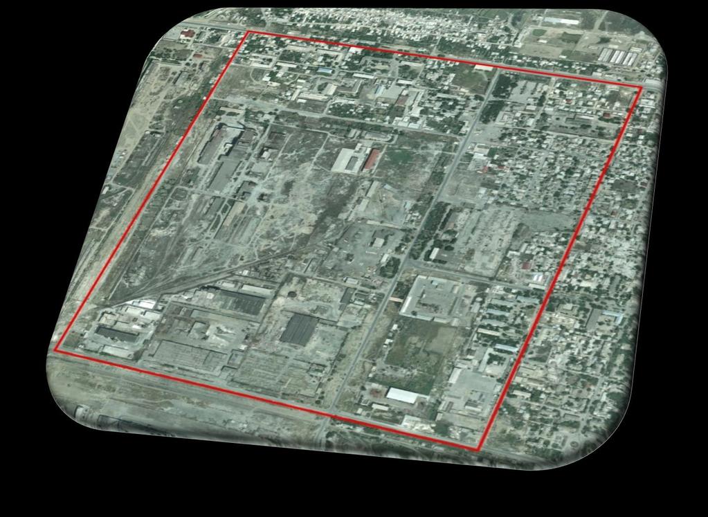
12 ORTHOPHOTO MAPS PRODUCED IN AZERBAIJAN Areas Scale of aero flights Scale of Orthophoto maps Areas covered by produced orthophotos Urban areas 1:8000 1: sq.km Rural areas 1: : sq.km Mountainous and borderline areas Satellite images 1: sq.km Fragment from the view of Baku city over orthophoto


13 COMPILATION OF DIGITAL MAPS THROUGH THE USE OF PHOTOGRAMMETRY


 The 300")


")
14 RESEARCH AND SYSTEMATIZATION OF ARCHIVE DOCUMENTS AutoCAD-dwg format Foxpro- dbf format (ДОС) The 300 dpi was scanned with sensitivity and was georeferens in the WGS-84 (zone 38-39) coordinate system in the UTM projection.


15 Activities and Time frame Public Awarness Mass media Seminars

16 Activities and Time frame Public Awareness leaflet to every household


17 Activities and Time frame / Training of local technicians / engineers GPS-RTK /surveying equipment PENMAP and GIS-Tools Graphical field book with software PENMAP


18 Activities and Time frame Surveying activities Surveying of rural areas in Sheki (village Zayzid) Agreement about the boundaries Data collection about the real estate objects


19 Activities and Aims for the Land Registrations / Cadastre Project Capturing of ownership and boundary-data on-site Complete area systematic surveying Simplification of registration process Data base for legal registration of ownership and for municipal and state land management

 Involvement of property owners")

20 Activities and Aims for the Land Registrations / Cadastre Project(cont.) Involvement of property owners in areas (fields) Public awareness and information campaign Public presentation of surveying results


21 21 DESCRIPTION OF LAND INFORMATION SYSTEM IN AZERBAIJAN (FRAGMENT)


22 Fragment of Land Electronic Cadastral Information System


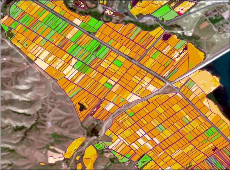
23 Fragment from land of Salyan region, Khalaj administrative district of the soil map Symbols Soil sampled point areas N-er of row 1 Color mark The name of the land L E G E N D Natural farming places Area planting pasture saline rush bush hectare in% I.Gray-grass lands Light clay, thick gray-meadow soils Heavy gray, gray-grass soils II. Open gray-grass lands Light clay, thick, light grassy soils Heavy clay, thick open grassy soils Other lands Total area

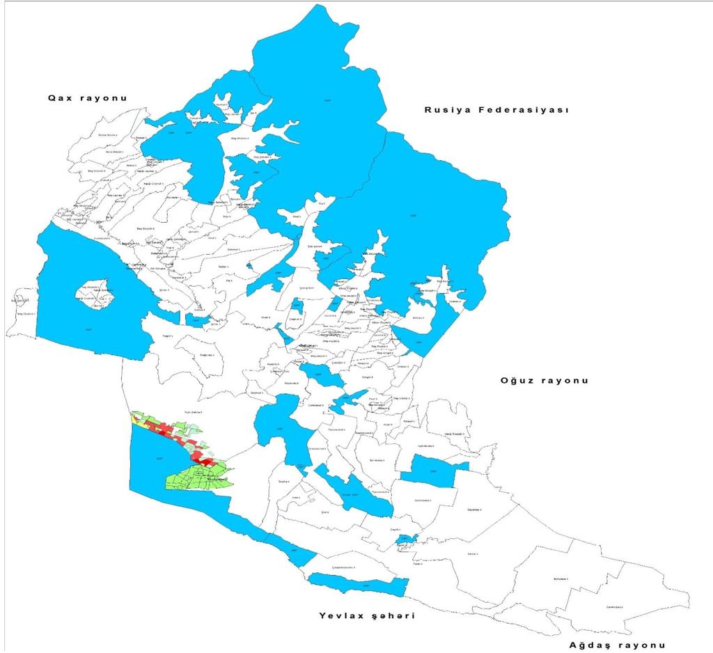
24 Fragment from of the Salyan region, Khalaj administrative district of the land salinization map Symbols sampled point areas N-er of row Color mark The name of the land L E G E N D A Natural farming places qamışlı planting pasture saline örüş Arae bush hectare in% 1 Unsalted land Slightly saline soils Medium saline soils Severe saline soils Other lands Total area

25 Land map of Sheki region
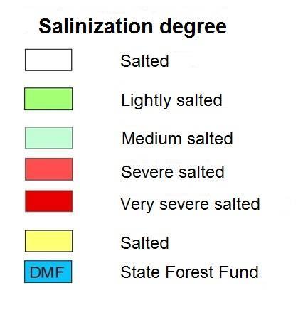
26 Salinization map of lands in Sheki region

27 Erosion map of the lands of Sheki region


28 Inclination map of the Sheki region (in 3D format)
29 As a result of establishment of electronic cadaster information system and compilation of digital cadaster maps: Compiling the maps reflecting the reality over the Republic will be achieved; State regulation of land resources management, property relations regulation will improve, state control over property (land) will be more flexible; Discrepancies between spatial indicators and actual positioning status in land reform documents will be eliminated; Solving problems with cadastral maps will provide a reliable condition for eliminating numerous land disputes; Determination of lands in the Republic will achieve to accurate cadaster record over type of land use; A reliable database will be established for making of necessary projects related to the preparation and implementation of complex measures related to land fertility enhancement and protection;
30 State Committee on Property İssues of Azerbaijan Republic Real Estate Cadastre and Address Registry Service Cadastre and Land Structuring Desing Research Centre Address:, 269 SH. Mehdiyev street, Yasamal region, city Baku telephone: THANK YOU FOR YOUR ATTENTION!
STATE COMMITTEE OF LAND AND CARTHOGRAPHY OF AZERBAIJAN REPUBLIC LAND MANAGEMENT IN THE AZERBAIJAN REPUBLIC
 STATE COMMITTEE OF LAND AND CARTHOGRAPHY OF AZERBAIJAN REPUBLIC LAND MANAGEMENT IN THE AZERBAIJAN REPUBLIC BUDAPEST - 2012 AZERBAIJAN REPUBLIC TERRITORY: 86 600 sq.km NUMBER OF INHABITANTS: 9.1 mln.people
Rural Land Market in Armenia: Formation Peculiarities and Development Trends
 Rural Land Market in Armenia: Formation Peculiarities and Development Trends Manuk Vardanyan Chairman of the state committee of the real property cadastre of the government of RA, Ph.D. Vahagn Grigoryan
Country report, HUNGARY
 Country report, HUNGARY Gyula IVÁN Institute of Geodesy, Cartography & Remote Sensing (FÖMI) HUNGARY FIG Commission 7 Annual Meeting 2009 12-16 October, 2009, Kuala Lumpur, Malaysia Institute of Geodesy,
BULGARIAN CADASTRE A GUARANTEE FOR THE OWNERSHIP RIGHTS IN IMMOVABLE PROPERTIES
 4 TH INTERNATIONAL CONFERENCE RECENT PROBLEMS IN GEODESY AND RELATED FIELDS WITH INTERNATIONAL IMPORTANCE February 28 - March 2, 2007, Inter Expo Centre, Sofia, Bulgaria BULGARIAN CADASTRE A GUARANTEE
REFORM OF LAND CADASTRE IN LITHUANIA
 REFORM OF LAND CADASTRE IN LITHUANIA Romualdas KASPERAVICIUS, Lithuania Key words: ABSTRACT Main aim for every Government is to create legal, financial and organisational circumstances for real property.
FIG/FAO International Seminar on State and Public Land Management
 FIG/FAO International Seminar on State and Public Land Management State Land Distribution for the Poor: State Land Identification, Mapping, Classification and Registration By Dr. Sareth Boramy Deputy General
Use of data in Ukraine for sustainable economic growth. Oleksandr Maliuk State Service of Ukraine for Geodesy, Cartography and Cadastre
 Use of data in Ukraine for sustainable economic growth Oleksandr Maliuk State Service of Ukraine for Geodesy, Cartography and Cadastre Kehl, 2017 Content of the presentation Ukraine & StateGeoCadastre:
STATE COMMITTEE OF THE REPUBLIC OF UZBEKISTAN ON LAND RESOURCES, GEODESIES, TO CARTOGRAPHY AND STATE INVENTORY
 STATE COMMITTEE OF THE REPUBLIC OF UZBEKISTAN ON LAND RESOURCES, GEODESIES, TO CARTOGRAPHY AND STATE INVENTORY Development of services in providing information on land resources and real estate, introduction
Land Tenure and Geospatial Data and Technology
 Land Tenure and Geospatial Data and Technology Ioana Bouvier E3/Land and Urban, USAID Senior Geospatial Analyst January 23, 2018 January 23, 2018 1 OUTLINE 1. Overview of geospatial data and technology
Technology-driven solutions for the innovation of land administration and management
 Technology-driven solutions for the innovation of land administration and management Technology and economic growth - Studies*find link between technology innovation and national economic prosperity especially,
Cadastral services and virtual office in e-cadastre
 Cadastral services and virtual office in e-cadastre Priit Kuus Estonian Land Board October 26, 2016 Coimbra Scope of data Cadastral parcels (as of September 2016) 674 383 cadastral parcels, i.e. 97,7 %
Unified Land Administration for a Better Spatial Infrastructure
 Unified Land Administration for a Better Spatial Infrastructure Gyula IVÁN Institute of Geodesy, Cartography & Remote Sensing FÖMI (HUNGARY) Open Symposium 30th Korean Cadastral Seminar & FIG Commission
Annual Meeting 2006 SLOVENIA, BLED RASAS GOFMANAS JAUNIUS GRIGAS RIMANTAS RAMANAUSKAS KESTUTIS TRECIOKAS
 Annual Meeting 2006 SLOVENIA, BLED LAND ADMINISTRATION IN LITHUANIA RASAS GOFMANAS JAUNIUS GRIGAS RIMANTAS RAMANAUSKAS KESTUTIS TRECIOKAS ADMINISTRATIVE STRUCTURE OF LITHUANIA HISTORY OF LAND ADMINISTRATION
Surveying in Austria. Congress Maanmittauspäivät Seinäjoki, 20 th March 2014
 Surveying in Austria Congress Maanmittauspäivät Seinäjoki, 20 th March 2014 Topics Facts, figures Organisational issues of surveying Role of the BEV Products, services The Cadastre Surveying Education
The World Bank Modernization of Real Property Registration and Cadastre (P151746)
") Public Disclosure Authorized EUROPE AND CENTRAL ASIA Uzbekistan Social, Urban, Rural and Resilience Global Practice Global Practice IBRD/IDA Investment Project Financing FY 2016 Seq No: 5 ARCHIVED on 23-Apr-2018
Public Disclosure Authorized EUROPE AND CENTRAL ASIA Uzbekistan Social, Urban, Rural and Resilience Global Practice Global Practice IBRD/IDA Investment Project Financing FY 2016 Seq No: 5 ARCHIVED on 23-Apr-2018
e-land Administration in Hungary
 e-land Administration in Hungary Piroska Zalaba senior counsellor, project manager Ministry of Agriculture and Rural Development Department of Lands and Mapping FIG SEMINAR Innsbruck, 2-4 June 2004 Land
Estonian e-cadastre as basis for efficient land management
 Estonian e-cadastre as basis for efficient land management Priit Kuus Estonian Land Board November 14, 2017 Tallinn Scope of data Cadastral parcels (as of October 2017) 693 026 cadastral parcels, i.e.
Republic of Bulgaria
 Geodesy, Cartography and Cadastre Agency Republic of Bulgaria www.cadastre.bg 24. 01. 2018 г., гр. София The Cadastre Legislation in Bulgaria - historical reference 1908 г. The Cadastre Act The objective
STATE LAND AUDIT REPORT
 STATE LAND AUDIT REPORT 1 Presentation to the Portfolio Committee on Rural Development and Land Reform M514 Marks Building 30 March 2011 CHIEF SURVEYOR GENERAL Mr M RIBA Content 2 Background Project Objectives
MASS REGISTRATION OF LAND PARCELS USING FIT-FOR-PURPOSE LAND ADMINISTRATION: PROCEDURES AND METHODS
 MASS REGISTRATION OF LAND PARCELS USING FIT-FOR-PURPOSE LAND ADMINISTRATION: PROCEDURES AND METHODS TAREK ZEIN Hansa Luftbild AG, Germany zein@hansaluftbild.de Paper prepared for presentation at the 2017
Geoinformation Technologies in Land Management and Beyond: Case of Georgia
 Geoinformation Technologies in Land Management and Beyond: Case of Georgia Joseph SALUKVADZE Professor, Department of Human Geography, Co-team Leader, Cadastre and Land Register Project, Co-financed by
Ownership Data in Cadastral Information System of Sofia (CIS Sofia) from the Available Cadastral Map
 from the Available Cadastral Map") Ownership Data in Cadastral Information System of Sofia (CIS Sofia) from the Available Cadastral Map Key words: ABSTRACT Lydmila LAZAROVA, Bulgaria CIS Sofia is created and maintained by GIS Sofia ltd,
Ownership Data in Cadastral Information System of Sofia (CIS Sofia) from the Available Cadastral Map Key words: ABSTRACT Lydmila LAZAROVA, Bulgaria CIS Sofia is created and maintained by GIS Sofia ltd,
The Contribution of Forest Owners Associations for the Forest Cadastre Implementation. João Gaspar Ana Navarro Ferreira PORTUGAL
 The Contribution of Forest Owners Associations for the Forest Cadastre Implementation João Gaspar Ana Navarro Ferreira PORTUGAL Motivation Lack of forestry cadastre; Unify all FOAs databases with common
GLOBAL GEOSPATIAL MANAGEMENT INFORMATION
 GLOBAL GEOSPATIAL MANAGEMENT INFORMATION SEOUL, KOREA 24 th to 26 th October 2011 COUNTRY REPORT - REPUBLIC OF BOTSWANA 1. INTRODUCTION 1.1. SOCIAL, ECONOMIC AND POLITICAL BACKGROUND Botswana attained
The implementation of the European Land Registry Document in EU Member States
 The implementation of the European Land Registry Document in EU Member States Presentation by the ELRN member by Republic of Poland Marta Rekawek-Pachwicewicz Polish Association of Registrars, Cracow Regional
NEW DEVELOPMENTS IN THE REAL PROPERTY REGISTER AND CADASTRE IN LITHUANIA
 NEW DEVELOPMENTS IN THE REAL PROPERTY REGISTER AND CADASTRE IN LITHUANIA Jaunius Grigas E-mail: jaunius.grigas@registrucentras.lt Verona, 2008 FUNCTIONS OF STATE ENTERPRISE CENTRE OF REGISTERS Registration
COMPUTERIZED SYSTEM SUPPORTING DEVELOPMENT OF LAND MARKET IN GEORGIA
 COMPUTERIZED SYSTEM SUPPORTING DEVELOPMENT OF LAND MARKET IN GEORGIA S. G. TSIRAMUA, I. S. MELASHVILI Land Registration Unit of Government of Georgian, World Bank and IFAD Agriculture Development Project.
The Multipurpose Hungarian Unified Land Registry System
 The Multipurpose Hungarian Unified Land Registry System András Osskó FIG Working Week Integrating Generation Stockholm, Sweden 14-19 June 2008 Republic of Hungary is located in Central Europe Neighbouring
Current Law Legislation for Land Consolidation in Turkey
 Legal Frameworks for Land Consolidation in Turkey Fatma Tüz Zehra GÜLSEVER Geodesy and Photogrammetry Engineer FYR Macedonia 19-21 June 2018 In Turkey due to inheritence law, agriculture land plots get
Problems of land consolidation in the Republic of Moldova. Stefan Calancea Ministry of Agriculture and Food Industry
 1 Problems of land consolidation in the Republic of Moldova Stefan Calancea Ministry of Agriculture and Food Industry Oleg Horjan Land Re-parceling Component, Second Rural Investment and Secrecies Project
LIS Development Project and Measures Proposed to Enhance Trust in the Land Administration System in Uganda
 Project for Design, Supply, Installation and Implementation of the Land Information System and Securing of Land Records (DeSILISoR) LIS Development Project and Measures Proposed to Enhance Trust in the
COUNTRY REPORT ON CADASTRE AND LAND REGISTRAION IN IRAN. By: Hamid Berenjkar, IRAN
 COUNTRY REPORT ON CADASTRE AND LAND REGISTRAION IN IRAN By: Hamid Berenjkar, IRAN Key words: Comprehensive Cadastre, Cadastre System, Cadastral Survey, Land Book, Iran ABSTRACT Land registration and cadastral
Integration of Public Service Procedures and Use of Cadastral Data
 Integration of Public Service Procedures and Use of Cadastral Data Signe Rudzite Head of Cadastre and Register Department The State Land Service Vilnius, 21.10.2013 Content General information Current
The Verification of the Modernization of the Real Estate Cadastre in the Context of the Quality of Cadastral Data Case Study
 Environmental Engineering 10th International Conference eissn 2029-7092 / eisbn 978-609-476-044-0 Vilnius Gediminas Technical University Lithuania, 27 28 April 2017 Article ID: enviro.2017.218 http://enviro.vgtu.lt
Theme II. Customers and Services NEW PROJECTS OF THE AGENZIA DEL TERRITORIO. Marco SELLERIE
 UNITED NATIONS ECONOMIC COMMISSION FOR EUROPE COMMITTEE ON HUMAN SETTLEMENTS WORKING PARTY ON LAND ADMINISTRATION Workshop "Customer - Co-operation - Services" Vienna, Austria 12-13 September 2002 Theme
LAND ADMINISTRATION IN LITHUANIA: CHALLENGES AND PERSPECTIVES
 UNECE WPLA Workshop Influence of Land Administration on People and Business, Cavtat, Croatia, October 2-3, 2008 LAND ADMINISTRATION IN LITHUANIA: CHALLENGES AND PERSPECTIVES Kestutis Sabaliauskas, Director
Building Integrated Land Information Systems and Development of NSDI
 Stig JÖNSSON, Sweden Key words: Land administration, land information systems, property formation, spatial data infrastructure, Inspire, institutional cooperation SUMMARY Lantmäteriet the Swedish agency
The Danish Digital Cadastral Map A Tool for Land Management
 The Danish Digital Cadastral Map A Tool for Land Management Søren CHRISTENSEN, Denmark Key words: Digital cadastre, restrictions pertaining to public law, land management. ABSTRACT The establishments of
Land Cadastre Act. Chapter 1. Passed RT I 1994, 74, 1324 Entry into force (except 3 which entered into force on 1.01.
 Issuer: Riigikogu Type: act In force from: 01.01.2011 In force until: 31.12.2014 Translation published: 24.10.2014 Passed 12.10.1994 RT I 1994, 74, 1324 Entry into force 08.11.1994 (except 3 which entered
TSO1C: Land Reforms. Commission 7
 TSO1C: Land Reforms. Commission 7 Development of & Implementation LIS. Building an effective Partnership to Reform Uganda s Land Administration (7320) Gasant Jacobs, Head: Business Development. Tax & Accounting
Addressing Land Sector Opportunities with Geospatial Information in Nepal
 The 20th UNRCC-AP and the 4th UN-GGIM-AP 5-10 October 2015 Jeju Island, Republic of Korea Addressing Land Sector Opportunities with Geospatial Information in Nepal Krishna Raj BC Executive Director Land
KCA ORGANIZATION GOVERNMENT OF KOSOVA MINSTRY OF PUBLIC SERVICES GOVERNMENT OF KOSOVA MINSTRY OF PUBLIC SERVICES
 Development of Cadastre and Land Management in Kosovo Prof. Dr. sc. Murat Meha, chief executive Hyzri Llabjani-Cadastral Expert * Hajzer Bublaku-Lawyer FIG Working Week 2004 in Athens, Greece, May 22-27,
Reliability of the Italian cadastral system data quality and improvement prospects
 Reliability of the Italian cadastral system data quality and improvement prospects Eng. Franco MAGGIO (Central Director for Cadastral, Cartographic and Land Registration Services) Eng. Arturo ANGELINI
Cadastral Information System of Sofia
 Alexander LAZAROV and Hristo DECHEV, Bulgaria Key words: ABSTRACT A new Cadastre and Property Register Act (CPRA) was passed in April 2000, setting up rules for the maintenance of these two registers.
Parcel Boundaries in the Czech Republic
 Parcel Boundaries in the Czech Republic CZECH REPUBLIC Jiri Rydval, Libor Tomandl Czech Office for Surveying, Mapping and Cadastre inhabitants - 10.3 million territory 78,865 km 2 2 Contents: 1. A parcel
SECTOR PUBLIC CADASTRES AND REGISTERS MARKET PARTICIPANTS
 E-SERVICES TO CITIZENS, GOVERNMENT AND BUSINESSES. LITHUANIA EXPERIENCE Arvydas Bagdonavičius State Enterprise Centre of Registers Arvydas.Bagdonavicius@registrucentras.lt REGISTERS AND IS MANAGED BY THE
International funding projects in Republic Geodetic Authority
 International funding projects in Republic Geodetic Authority Serbia: Republic Geodetic Authority Workshop Exploring Funding Instruments for NMCA 7-8 November 2012 Republic Geodetic Authority Republic
Quality Improvement of the Real Estate Cadastre in Serbia
 , Serbia Key words: quality improvement, real estate information, quality assurance, Serbia SUMMARY The concept of cadastral modernization in the Republic of Serbia was defined in 1992, and it is being
Development of Cadastral Survey and Land Ownership Registration System in Mongolia
 Development of Cadastral Survey and Land Ownership Registration System in Mongolia M.Saandar,, Ph. D Vice President, the Mongolian Association of Surveying and Mapping, ( As National Member of FIG ) MonMap
PCC conference Tällberg. Aspects on development cooperation
 PCC conference Tällberg Aspects on development cooperation PCC conference Tällberg WHO I AM Anders Åberg, Project Leader Posted over seas 10 years Tanzania 1978 1980 Vietnam 1987 1990 Laos 2004 2008 Now
Land Consolidation in Sweden and Land
 From chaos to order... Land Consolidation in Sweden and Land Reform in Romaniasimilarities and discrepancies a comparison Mats Backman June 16 th 2008 Personal presentation Land Consolidation work in Sweden
International Workshop Land Banking/Land Funds as an Instrument for Improved Land Management for CEEC and CIS March 2004 Tonder,, Denmark
 MINISTRY OF AGRICULTURE AND FORESTRY SOFIA, BULGARIA International Workshop Land Banking/Land Funds as an Instrument for Improved Land Management for CEEC and CIS 17-20 March 2004 Tonder,, Denmark BULGARIAN
Public and State Land Management in Hungary
 Public and State Land Management in Hungary ANDRÁS OSSKÓ WORKING WEEK 2012 May 6-10 2012 ROME, ITALY CONTENT 1. Introduction 2. Legal and institutional background 3. Activities of the national land fund
Quality Improvement to Cadastral Information in Sweden
 Gunnar BLIXT, Sweden Key words: digital cadastre, quality, cadastral index map, real property register. SUMMARY Lantmäteriet is a governmental agency which gives support for creating an efficient and sustainable
Establishing a Land policy reform and GPS Technology implementation in Burkina Faso
 Annual World Bank Conference on Land and Poverty 2013 Establishing a Land policy reform and GPS Technology implementation in Burkina Faso Presentation made by Moha EL-AYACHI, IAV Hassan 2, Morocco Paper
An Approach to Integration of Land Administration System
 An Approach to Integration of Land Administration System, Republic of Korea Key words: Land Administration System, Integration, South Korea SUMMARY Korea s modern land system was enforced after the land
Amalia Velasco Carlos Alonso Luis Virgos Fernando Serrano
 Inspire services of the Spanish Directorate General for Cadastre and its use to resolve an old problem of coordination between Spanish Cadastre and Land Registry. Amalia Velasco Carlos Alonso Luis Virgos
Reporting Thailand Cadastral System in Cadastre 2014 Trends BY VUTTINAN UTESNAN. Rajamangala University of Technology Krungthep
 Reporting Thailand Cadastral System in Cadastre 2014 Trends BY VUTTINAN UTESNAN Rajamangala University of Technology Krungthep Faculty of Engineering, Bangkok, THAILAND Topics INTRODUCTION THAILAND CADASTRAL
Establishment of a land market in Ukraine: current state and prospects
 Establishment of a land market in Ukraine: current state and prospects More than 25 years have passed since the adoption of the first resolution of the Verkhovna Rada On Land Reform. Despite such a long
XXV FIG CONGRESS KUALA LUMPUR, MALAYSIA, JUNE 2014.
 XXV FIG CONGRESS KUALA LUMPUR, MALAYSIA, 16-21 JUNE. THEME: ENGAGING THE CHALLENGES, ENHANCING THE RELEVANCE THE DILEMMA Malaysia, 16 21 OF June RESTRUCTURING THE LAND GOVERNANCE SYSTEM IN NIGERIA BY UKAEJIOFO,
Role of Republic Geodetic Authority in the Serbian geo-sector
 Role of Republic Geodetic Authority in the Serbian geo-sector Republic Geodetic Authority, Serbia www.rgz.gov.rs EuroGeographics General Assembly 2014 Moldova, Chisinau, 28 th 30 th September 2014 The
Property Based Land Information Systems of Turkey
 Property Based Land Information Systems of Turkey Mehmet Fatih DİRİ, Bilgehan ÖZSOY, Ünsal ERGÜN, Turkey Key words: Cadaster, Land Registry, GIS, Property, TURKEY SUMMARY The property, addition to the
DATR towards e-land Administration in Hungary
 DATR towards e-land Administration in Hungary Gyula IVÁN-Gábor SZABÓ-Zoltán WENINGER-Piroska Zalaba Institute of Geodesy, Cartography and Remote Sensing, Budapest, HUNGARY XXIV. FIG Congress Facing the
Egyptian Nationwide Title Cadastre System
 Kholoud SAAD, Egypt Key words: Cadastre, Registration, Urban, Rural, National Cadastre, Automation, reengineering. SUMMARY With growing need for integrated information, Enterprise Solutions has become
A FIRST ATTEMPT FOR USING VOLUNTEERED GEOGRAPHIC INFORMATION AND CROWD SOURCING TECHNIQUES IN CADASTRE
 A FIRST ATTEMPT FOR USING VOLUNTEERED GEOGRAPHIC INFORMATION AND CROWD SOURCING TECHNIQUES IN CADASTRE Sofia Basiouka National Technical University of Athens PhD student s.basiouka@gmail.com Chryssy Potsiou
Functional system for cadastral plans
 , Republic of Macedonia Key words: Cadastre, Digital plans, Data, System SUMMARY The analysis shows that the real estate market in Republic of Macedonia grows daily. With the expansion of this market increases
Establishing Efficient Cadastral Surveying Plan in Accordance with Introducing World Geodetic Reference System in Korea
 Modern Environmental Science and Engineering (ISSN 2333-2581) December 2015, Volume 1, No. 6, pp. 299-303 Doi: 10.15341/mese(2333-2581)/06.01.2015/003 Academic Star Publishing Company, 2015 www.academicstar.us
Spatial Data Warehouse Ltd. Cadastral Mapping INITIATIVE 1: CADASTRAL MAPPING. Version Spatial Data Warehouse Ltd. & AltaLIS Ltd.
 Spatial Data Warehouse Ltd. Initiative 1: Cadastral Mapping INITIATIVE 1: CADASTRAL MAPPING 29 P3 The SDW/AltaLIS Model Background The Government of Alberta started a mapping program, the Municipal Integrated
Status and Perspectives of the Geodesy, Cartography and Cadastre Authority Availability of Geographic Information in Slovakia.
 Status and Perspectives of the Geodesy, Cartography and Cadastre Authority Availability of Geographic Information in Slovakia Hedviga Májovská Geodesy, Cartography and Cadastre Authority of the Slovak
THE REPUBLIC OF TURKEY MINISTRY OF PUBLIC WORKS GENERAL DIRECTORATE OF LAND REGISTRY AND CADASTRE (TKGM) UNECE WPLA WORKSHOP. October 2010.
 UNECE WPLA WORKSHOP. October 2010.") THE REPUBLIC OF TURKEY MINISTRY OF PUBLIC WORKS GENERAL DIRECTORATE OF LAND REGISTRY AND CADASTRE (TKGM) UNECE WPLA WORKSHOP " The role of spatial planning to improve security of tenure" October 2010 Antalya
THE REPUBLIC OF TURKEY MINISTRY OF PUBLIC WORKS GENERAL DIRECTORATE OF LAND REGISTRY AND CADASTRE (TKGM) UNECE WPLA WORKSHOP " The role of spatial planning to improve security of tenure" October 2010 Antalya
The Role of the Swedish Land Information System
 The Role of the Swedish Land Information System In the Business Society Tommy Österberg Swedesurvey 1 SWEDEN 9 million inhabitants 450 000 sq. km 21 Counties 291 Municipalities 4.6 million properties in
Iranian Cadastre System. Nasrollah Jahangard Iran s Deeds and Properties Registration Organization I.R. of Iran 14 th PCGIAP, KL, Malaysia 2008
 Iranian Cadastre System Nasrollah Jahangard Iran s Deeds and Properties Registration Organization I.R. of Iran 14 th PCGIAP, KL, Malaysia 2008 General Information Europe Middle East Asia Africa Middle
INDIAN INSTITUTE OF TECHNOLOGY ROORKEE. Presentation on REAL TIME CADASTRAL SURVEYING SOLUTION WITH A SPECIAL IMPHESIS TO MODERN GPS TECHNOLOGY.
 INDIAN INSTITUTE OF TECHNOLOGY ROORKEE Presentation on REAL TIME CADASTRAL SURVEYING SOLUTION WITH A SPECIAL IMPHESIS TO MODERN GPS TECHNOLOGY By: Prof. Kamal Jain, Dept. of Civil Engg. IIT-Roorkee AIM
Procedures for the legalization and registration of buildings and building units Challenges and Problems Building cadastre in Slovenia
 Procedures for the legalization and registration of buildings and building units Challenges and Problems Building cadastre in Slovenia Edvard Mivšek M.Sc. Geodetic institut of Slovenija Pristina, 19 April
Experiences with land consolidation and land banking in Slovenia since 1991
 Experiences with land consolidation and land banking in Slovenia since 1991 Anka LISEC University of Ljubljana Faculty of Civil and Geodetic Engineering anka.lisec@fgg.uni-lj.si University of Ljubljana
Cadastral data services in Estonia
 Cadastral data services in Estonia Mr. Priit Kuus Department of Land Cadastre priit.kuus@maaamet.ee +372 675 0843 Ventspils 2013 Cadastre today Land Cadastre Act Adopted on 12 Oct.1994, since then amended
ABSTRACT Land Administration System in Lithuania
 ABSTRACT Land Administration System in Lithuania 1. General introduction to the Lithuanian Land Administration System and State Enterprise Centre of Registers ( shortly SECR) Lithuania has established
Agricultural Land Reform and Land Consolidation in Romania
 Consolidation and Territorial Organization Prague, March 6-10, 2005 Agricultural Reform and Consolidation Romania VIRGIL PAMFIL Deputy director Regional Trag Center Mistry of Admistration and Internal
Regional Cadastral Study Reforms in the Region
 UNECE WORKING PARTY ON LAND ADMINISTRATION Workshop on the Influence of Land Administration on People and Business Cavtat, Croatia 2-3 October 2008 Regional Cadastral Study Reforms in the Region Miodrag
CADASTRAL WORKS in TURKEY AND GDLRC (TKGM)
") CADASTRAL WORKS in TURKEY AND GDLRC (TKGM) NOVEMBER 2011 SOME NUMBERS ABOUT TURKEY Area :783.600 Km 2 Population : 747 millions (2008) Number of land parcels : 555 millions Villages and quarters : 52.437
CADASTRAL WORKS in TURKEY AND GDLRC (TKGM) NOVEMBER 2011 SOME NUMBERS ABOUT TURKEY Area :783.600 Km 2 Population : 747 millions (2008) Number of land parcels : 555 millions Villages and quarters : 52.437
The Boundary and the Effects of Cadastral Surveying in Cyprus
 The Boundary and the Effects of Cadastral Surveying in Cyprus Aristi Louca, Margarita Fani Surveyor Engineers, Cyprus Association of Rural and Surveying Engineers The History of Cyprus goes back 11000
FIG-WB Forum on Land Administration
 FIG-WB Forum on Land Administration and Reform in Sub-Sahara Africa [Nigeria] [Peter O. Adeniyi] FIG WORKING WEEK, Abuja, NIGERIA 2013-6-10 MAY 2013 Statistic Country at a Glance Total population 162,470,737
International Training Program (ITP) Coordinated Mentor Training Program
 Coordinated Mentor Training Program") Coordinated Mentor Training Program Presented at the FIG Congress 2018, May 6-11, 2018 in Istanbul, Turkey International Training Program (ITP) Paper no 9587: Peter Wasström, Head of International Services
Coordinated Mentor Training Program Presented at the FIG Congress 2018, May 6-11, 2018 in Istanbul, Turkey International Training Program (ITP) Paper no 9587: Peter Wasström, Head of International Services
Land Administration System in Russian Federation
 Sergey VOLKOV, Russia Key words: land administration, market economy, land management, land resources. SUMMARY Principle source of economic and social development of Russian Federation in XXI century will
UPDATING OF CADASTRAL DATABASE WITH A VIEW TO THE CREATION OF VINEYARDS AND FRUIT TREES
 Lucrări Ştiinţifice vol. 59(1)/2016, seria Agronomie UPDATING OF CADASTRAL DATABASE WITH A VIEW TO THE CREATION OF VINEYARDS AND FRUIT TREES Cristian HUŢANU 1, Oprea RADU 1, Dan PĂDURE 2 e-mail: hutanucrst@yahoo.com
Field surveying inspection using tablets
 Field surveying inspection using tablets Rami Farraj, Ahmad Sghyyer Survey of Israel, Lincoln 1, Tel-Aviv, Israel rami@mapi.gov.il ahmad@mapi.gov.il Key words: Field Surveying, Cadastre, Mapping Procedures
ASSESSMENT OF CONSEQUENCES RESULTING FROM ABOLISHING THE OBSTACLES ON LAND TRANSACTIONS 1 SUMMARY
 ASSESSMENT OF CONSEQUENCES RESULTING FROM ABOLISHING THE OBSTACLES ON LAND TRANSACTIONS 1 SUMMARY I. Foreign practice in regulation of land market and the EU legal provisions Having analysed the existing
LAND REFORM IN MALAWI
 LAND REFORM IN MALAWI Presented at the Annual Meeting for FIG Commission 7 In Pretoria, South Africa, Held From 4 th 8 th November, 2002 by Daniel O. C. Gondwe 1.0 BACKGROUND Malawi is a landlocked country
Problems and Solution Proposals in Integration of Cadastral Data into Geographical Information System (GIS) in Turkey
 in Turkey") Problems and Solution Proposals in Integration of Cadastral Data into Geographical Information System (GIS) in Turkey Gülgün OZKAN, S. Savas DURDURAN, Ali ERDI and Bilal GIRGIN, Turkey Key words: Cadastre,
Problems and Solution Proposals in Integration of Cadastral Data into Geographical Information System (GIS) in Turkey Gülgün OZKAN, S. Savas DURDURAN, Ali ERDI and Bilal GIRGIN, Turkey Key words: Cadastre,
New Cadastral Mapping in the Czech Republic
 New Cadastral Mapping in the Czech Republic Karel Štencel, Svatava Dokoupilová, Jan Kmínek Czech Office for Surveying, Mapping and Cadastre Basic Data about the Czech Republic Area: 78 866 km 2 Population:
Croatian SDI: a Tool for Accelerated Development of the Geo-Conscious Society
 STATE GEODETIC ADMINISTRATION Croatian SDI: a Tool for Accelerated Development of the Geo-Conscious Society Prof.Dr.Sc. Željko Bačić, Mr.Sc. Ljerka Rašić FIG Working Week 2009 - Surveyors Key Role in Accelerated
Saulius Milevičius, Lithuanian Surveyors Association Head of the Internet Map Application Designing Group SE Centre of Registers
 LITHUANIAN EXPERIENCE IN CADASTRE Saulius Milevičius, Lithuanian Surveyors Association Head of the Internet Map Application Designing Group SE Centre of Registers Jolanta Česnauskienė, Jolanta Česnauskienė,
AREC responsibilities, data and registries and the way of their distribution
 Data as a basis of the digital society PCC, 13-15 March 2018, Sofia AREC responsibilities, data and registries and the way of their distribution Vlatko Dimovski Agency for Real Estate Cadastre (AREC) the
LAND ADMINISTRATION DEVELOPMENTS IN RWANDA
 LAND ADMINISTRATION DEVELOPMENTS IN RWANDA, Rwanda Key words : Land tenure security, land registration, land rights, land commissions. SUMMARY : The new Rwandan land policy consider appropriate land administration
e-cadastre and Photo-Interpretation Technologies
 UNECE- WPLA EFFICIENT AND TRANSPARENT LAND MANAGEMENT IN ECE COUNTRIES 4 March 2010 - Baku, Azerbaijan e-cadastre and Photo-Interpretation Technologies The Italian experience as an example of Good Practice
Hungary is a landlocked, Central European country in the Carpathian Basin
 Brief Overview on Hungarian Land Administration MSc. György Domokos Hungarian Geodetic Surveying Liaison Group CLGE GA Hannover 12 13 October 2012 Hungary is a landlocked, Central European country in the
IMPACT OF REAL PROPERTY MARKET ON CHANGES OF CADASTRAL VALUE AND FORMATION OF SAMARA REGIONAL BUDGET
 IMPACT OF REAL PROPERTY MARKET ON CHANGES OF CADASTRAL VALUE AND FORMATION OF SAMARA REGIONAL BUDGET Gabibulla Khasaev 1, Dr.Sc., professor; Alexandr Vlasov 2, Cand.Sc., professor; Dariya Vasilieva 3,
Progress Report on Green Paper. Dr. Paddy Prendergast. on behalf of the. IIS Commission on Land Registration
 Progress Report on Green Paper By Dr. Paddy Prendergast on behalf of the IIS Commission on Land Registration Paddy Prendergast - Chair Brendan Sweeny - Hempenstall Surveys Paul Corrigan - P Corrigan Associates
Learning from land suitability analysis and Dutch spatial policy for sustainable land use in Japan
 Learning from land suitability analysis and Dutch spatial policy for sustainable land use in Japan Toru Nagayama 22 January 2009 GIS Research Group Seminar, University of Tsukuba Highlights from : Nagayama.,
Land Administration and Spatial Enablement Victoria s Experience. Chris McRae, Executive Director Land Victoria
 Land Administration and Spatial Enablement Victoria s Experience Chris McRae, Executive Director Land Victoria 4 th UN Land Administration Forum, October 2011 Outline About Land Victoria Land Victoria