Large scale maps from Regions point of view. RNDr. Ivo Skrášek Head of IT department Zlín Region
|
|
|
- Ashlie Dixon
- 5 years ago
- Views:
Transcription


1 Large scale maps from Regions point of view RNDr. Ivo Skrášek Head of IT department Zlín Region
2 Table of Content 1.Short characteristic of Digital cadastral map and Digital technical map 2. Experience of Zlín Region with Digital technical map
3 1. Digital cadastral map and Digital technical map There are two major large scale digital vector maps in the Czech republic: Digital cadastral map (DCM) Digital technical map (DTM) They have fundamentally different content, but they have some same features (eg.buildings) They complement each other together they provide an important source of information for the agendas of state-government and self-government
4 2. Digital cadastral map The map is created for need of cadastre of real estate in the Czech republic cadastral map is an obligatory State Map Series of a large scale displays the boundary of a plot, building objects, boundary of cadastre unit, description and other subjects in the extent prescribed by annex decrees Nr. 26/2007 Coll.
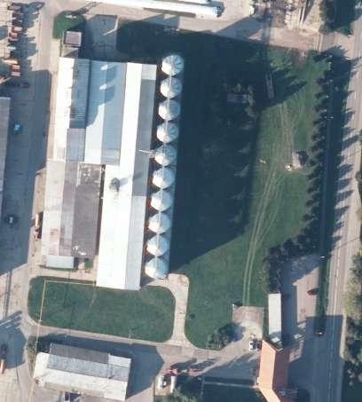
5 3. Sample of the Digital cadastral map
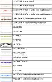
6 4. Digital technical Map - map of town utilities The map is created to obtain the actual situation in the territory Digital Technical map consists: From the planimetry situation displays objects (eg. buildings, interface areas, surface features of utilities line, pillars, fences) From the utilities line (aboveground and underground) water line, sewage system, gas pipelines, telephone lines etc.


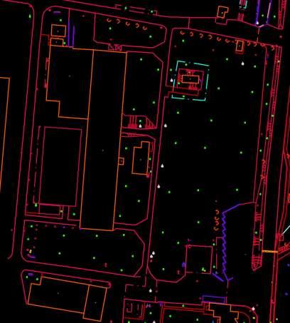
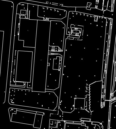
7 5. Sample of the Digital technical map


8 6. The comparision of the maps I Digital cadastral map Digital technical map

9 7. The comparision of the maps II Digital cadastral map Digital technical map
10 8. The comparision of DCM and DTM - I. Digital cadastral map Digital technical map Status in legislation State Map series No State Map series Guarantee Czech Office for Surveying, Mapping and Cadastre (ČUZK) obligation Municipalities (They cooperate with the administrators of utilities, Regions) oportunity Altimetry NO YES Data model Uniform Diverse
 Cadastral")
11 9. The comparison of DKM a DTM - II. Digital Cadastral maps They have different way of creation and with that associated accuracy and content Digital cadastral map(dcm) Cadastral map digitalized (CDM) Digital Technical maps They differ by completeness of measurement Complete (cities) Types
 is Specialpurpose")
12 10. The comparision of DCM and DTM - III. Digital cadastral maps Digital technical maps In areas without Digital Cadastral map (DCM or CMD) is Specialpurpose cadastral map (UKM) Street line municipalities Types It does not include all parcels
13 11. The comparision of KMD a DTM - IV. Coverage of the area Digital cadastral maps Today is about 70 % of all cadastr unit finished (DCM + CMD) % Digital technical map Only in some cities and municipalities It is hard to estimate the number about 1000?
14 12. The comparision of KM and DTM - V. Accessibility Digital Cadastral map Absolutely accessed (One-time, online, sevices) Digital Technical map Accessed partially Accuracy DCM complies with all tasks CMD does not comply with all tasks due to positional accuracy UKM(OMP) does not comply to all tasks due to content and positional accuracy Complies with all tasks
15 13. How is Digital technical map created? By the cooperation between cities and municipalities with administrators of utility networks: City (municipality) in cooperation with managers of utility lines create DTM and its management system By decree they define obligation to builders to document changes in DTM The creation and updating is funded by the city and managers of UL Since 2012, these is full legislative support for production and management of digital Technical maps of cities and municipalities
16 14. Why are self-governments involved in the DTM? DTM is used in many agendas of self-government and stategovernment, especially in: in teritorrial planning in emergency management in property passport (even municipalities own utilitity lines) in project work To simplify and accelerate the processes associated with the construction management service for citizens
17 15. Regions and Digital technical map There is about municipalities in the Czech Republic, half of them have less than 382 inhabitants It is unrealistic for them to be able to take care of the DTM Therefore, Regions help to coordinate the creation and updating DTM in collaboration with the managers of the utility lines Regions create uniform system of DTM management for cities and municipalities in its area and standardize data and services So far in 7 out of 13 regions


18 16. The experience of the Zlín Region users of DTM Uniform formation of Digital Technical maps since 2003 Involved 300 of 306 municipalities in the region Involved 8 crucial managers of utility lines 2490 registered users

19 17. The experince of the Zlín Region access to the Portal DTM

20 18. The experince of the Zlín Region contracts in DTM Warehouse Updating contract Contract for planners
21 Thank you for the attention.
Refinement of Cadastral Maps
 Acta Montanistica Slovaca Ročník 16(2011), číslo 4, 242-248 Refinement of Cadastral Maps Alena Berková 1 Making cadastral maps more precise The amended cadastral ordinance takes effect from 1.7. 2009.
Parcel Boundaries in the Czech Republic
 Parcel Boundaries in the Czech Republic CZECH REPUBLIC Jiri Rydval, Libor Tomandl Czech Office for Surveying, Mapping and Cadastre inhabitants - 10.3 million territory 78,865 km 2 2 Contents: 1. A parcel
STATE COMMITTEE OF THE REPUBLIC OF UZBEKISTAN ON LAND RESOURCES, GEODESIES, TO CARTOGRAPHY AND STATE INVENTORY
 STATE COMMITTEE OF THE REPUBLIC OF UZBEKISTAN ON LAND RESOURCES, GEODESIES, TO CARTOGRAPHY AND STATE INVENTORY Development of services in providing information on land resources and real estate, introduction
Republic of Bulgaria
 Geodesy, Cartography and Cadastre Agency Republic of Bulgaria www.cadastre.bg 24. 01. 2018 г., гр. София The Cadastre Legislation in Bulgaria - historical reference 1908 г. The Cadastre Act The objective
INSPIRE, GDPR and the Czech Real Estate Cadastre. Jiří Poláček Czech Office for Surveying, Mapping and Cadastre (ČÚZK)
") INSPIRE, GDPR and the Czech Real Estate Cadastre Jiří Poláček Czech Office for Surveying, Mapping and Cadastre (ČÚZK) Agenda GDPR principles Source data information systems and workflow GDPR and INSPIRE
INSPIRE, GDPR and the Czech Real Estate Cadastre Jiří Poláček Czech Office for Surveying, Mapping and Cadastre (ČÚZK) Agenda GDPR principles Source data information systems and workflow GDPR and INSPIRE
Use of data in Ukraine for sustainable economic growth. Oleksandr Maliuk State Service of Ukraine for Geodesy, Cartography and Cadastre
 Use of data in Ukraine for sustainable economic growth Oleksandr Maliuk State Service of Ukraine for Geodesy, Cartography and Cadastre Kehl, 2017 Content of the presentation Ukraine & StateGeoCadastre:
The Multi-Purpose Information System of Real Estates in the Czech Republic. Vladimíra ŽUFANOVÁ, Czech Republic
 The Multi-Purpose Information System of Real Estates in the Czech Republic Vladimíra ŽUFANOVÁ, Czech Republic Key words: Cadastre; Land management SUMMARY The Cadastre of Real Estate and Land administration,
INSPIRE implementation as a link between egovernment and environmental purposes
 INSPIRE implementation as a link between egovernment and environmental purposes Jiří Poláček Czech Office for Surveying, Mapping and Cadastre (ČÚZK) Agenda Role of ČÚZK branch in the INSPIRE implementation.
New Cadastral Mapping in the Czech Republic
 New Cadastral Mapping in the Czech Republic Karel Štencel, Svatava Dokoupilová, Jan Kmínek Czech Office for Surveying, Mapping and Cadastre Basic Data about the Czech Republic Area: 78 866 km 2 Population:
The Development of the Austrian Cadastre from Documentation to an Integrated Planning and Decision Support System
 The Development of the Austrian Cadastre from Documentation to an Integrated Planning and Decision Support System WPLA - Working Party on Land Administration 15-17 October 2014, Vienna, Austria Wernher
INSPIRE implementation as a link between egovernment and environmental purposes
 INSPIRE implementation as a link between egovernment and environmental purposes Jiří Poláček Czech Office for Surveying, Mapping and Cadastre (ČÚZK) What s to Come Role of ČÚZK branch in the INSPIRE implementation.
Office for Government Representation in Property Affairs (OGRPA) MEMBER UPDATE
 MEMBER UPDATE") Office for Government Representation in Property Affairs (OGRPA) MEMBER UPDATE Annual Conference PuRE-net, Oslo, 25.- 28. 9. 2016 RE PROPERTY IN CZECH REPUBLIC & OGRPA Decentralized state RE ownership
Office for Government Representation in Property Affairs (OGRPA) MEMBER UPDATE Annual Conference PuRE-net, Oslo, 25.- 28. 9. 2016 RE PROPERTY IN CZECH REPUBLIC & OGRPA Decentralized state RE ownership
BULGARIAN CADASTRE A GUARANTEE FOR THE OWNERSHIP RIGHTS IN IMMOVABLE PROPERTIES
 4 TH INTERNATIONAL CONFERENCE RECENT PROBLEMS IN GEODESY AND RELATED FIELDS WITH INTERNATIONAL IMPORTANCE February 28 - March 2, 2007, Inter Expo Centre, Sofia, Bulgaria BULGARIAN CADASTRE A GUARANTEE
Recent development in Land Administration in the Czech Republic
 Recent development in Land Administration in the Czech Republic Contribution to discussion prepared by the Czech delegation 5th session of UNECE WPLA Item 3 of agenda Geneva, 19-20 November 2007 Czech
Country Profile for the Cadastre of the Czech Republic Based on LADM
 Country Profile for the Cadastre of the Czech Republic Based on LADM Karel Janečka 1, Petr Souček 2 1 University of West Bohemia, Pilsen, Czech Republic 2 Czech Office for Surveying, Mapping and Cadastre,
The Governance of Land Use
 The Governance of Land Use Country fact sheet Sweden The planning system Levels of government and their responsibilities Sweden is a unitary country with 3 levels of government; the national level, 21
Designing for transparency and participation in the Hellenic Cadastral Project
 Designing for transparency and participation in the Hellenic Cadastral Project Dr. Dimitris Rokos Director of Planning and Investments, Hellenic National Cadastre and Mapping Agency S.A. Table of Contents
Annual Report Of the Czech Office for Surveying, Mapping and Cadastre For 2017
 Annual Report Of the Czech Office for Surveying, Mapping and Cadastre For 2017 Prague, 2018 1 CONTENT Introduction 1. Surveying, Mapping and Cadastre Sector in the Czech Republic 2. Administration of the
Role of spatial planning in modern society
 Republic of Croatia State Geodetic Administration The Role of Cadastre in the Development of Regional and Local Planning Structure in Croatia Zdravko Cesarec and Željko Bačić 1 Role of spatial planning
Reliability of the Italian cadastral system data quality and improvement prospects
 Reliability of the Italian cadastral system data quality and improvement prospects Eng. Franco MAGGIO (Central Director for Cadastral, Cartographic and Land Registration Services) Eng. Arturo ANGELINI
Recent Developments concerning Land Administration in Austria
 Recent Developments concerning Land Administration in Austria Main topics e-government reference data go online / egeodata Austria new pricing and licensing / business models INSPIRE / PSI / national infrastructure
COOPERATION BETWEEN PUBLIC AND PRIVATE SECTOR - PROJECT OF DIGITALIZATION OF THE CADASTRAL MAPS IN THE CZECH REPUBLIC
 COOPERATION BETWEEN PUBLIC AND PRIVATE SECTOR - PROJECT OF DIGITALIZATION OF THE CADASTRAL MAPS IN THE CZECH REPUBLIC Keywords: Cadastre of Real Estate, Czech Office for Surveying, Mapping and Cadastre
Annual Report Of the Czech Office for Surveying, Mapping and Cadastre For 2016
 Annual Report Of the Czech Office for Surveying, Mapping and Cadastre For 2016 Prague, 2017 1 CONTENT Introduction 1. Surveying, Mapping and Cadastre Sector in the Czech Republic 2. Administration of the
Ordinance on Official Cadastral Surveying
 English is not an official language of the Swiss Confederation. This translation is provided for information purposes only and has no legal force. Ordinance on Official Cadastral Surveying 211.432.2 of
Experience in Innovative Technologies Application to Change Urban Space for Sustainable Territory Development
 IOP Conference Series: Materials Science and Engineering PAPER OPEN ACCESS Experience in Innovative Technologies Application to Change Urban Space for Sustainable Territory Development To cite this article:
Tradition and Innovation in Czech Cadastre. Karel Večeře Martina Hercegová Jan Kmínek Czech Office for Surveying, Mapping and Cadastre
 Tradition and Innovation in Czech Cadastre Karel Večeře Martina Hercegová Jan Kmínek Czech Office for Surveying, Mapping and Cadastre Land Registration and Cadastre History 13 th cent. Land Tables - predecessor
The (Legal) Reliability of the Cadastre from the Perspective of the Czech Republic. Mgr. Martina Hercegová Ing. Karel Štencel
 Reliability of the Cadastre from the Perspective of the Czech Republic. Mgr. Martina Hercegová Ing. Karel Štencel") The (Legal) Reliability of the Cadastre from the Perspective of the Czech Republic Mgr. Martina Hercegová Ing. Karel Štencel PCC - Conference Vienna 20. 21. 11. 2018 Basic information about the CR Area:
The (Legal) Reliability of the Cadastre from the Perspective of the Czech Republic Mgr. Martina Hercegová Ing. Karel Štencel PCC - Conference Vienna 20. 21. 11. 2018 Basic information about the CR Area:
EXPANDING AVAILABILITY OF BROADBAND ACCESS AND ADOPTION
 Single point information Ilija Kepevski Agency for Electronic Communications Regional Conference for Europe EXPANDING AVAILABILITY OF BROADBAND ACCESS AND ADOPTION 28-29 September 2015 - Budva, Montenegro
FIG-WB Forum on Land Administration
 FIG-WB Forum on Land Administration and Reform in Sub-Sahara Africa [Nigeria] [Peter O. Adeniyi] FIG WORKING WEEK, Abuja, NIGERIA 2013-6-10 MAY 2013 Statistic Country at a Glance Total population 162,470,737
Cadastral services and virtual office in e-cadastre
 Cadastral services and virtual office in e-cadastre Priit Kuus Estonian Land Board October 26, 2016 Coimbra Scope of data Cadastral parcels (as of September 2016) 674 383 cadastral parcels, i.e. 97,7 %
Challenges for the multi purpose cadastre
 Jens RIECKEN, Markus SEIFERT, Germany Key words: Multi purpose cadastre, 3d-cadastre, land use, SDI, solar cadastre SUMMARY Over the past 30 years, with the progress of information technologies the development
Support to Implementation of Multipurpose Cadastral Information system in Vietnam
 Support to Implementation of Multipurpose Cadastral Information system in Vietnam Lennart JOHANSSON and Per SÖRBOM, Sweden Key words: Land Registration, Land Information, Land Administration, SWOT analyse,
Surveyors Qualifications
 Surveyors Qualifications Præludium Surveyors Qualifications Lars Jansson, Director Lantmäteriet Henning Elmstrøm, President DdL 1 Agenda 1. Introduction 2. Basic framework conditions for cadastral systems
UNECE Working Party on Land Administration. Report on the Activities Carried Out by the UNECE WPLA Since the Committee's 72nd Session
 UNECE Working Party on Land Administration Report on the Activities Carried Out by the UNECE WPLA Since the Committee's 72nd Session Damir Pahic, dipl.ing. UNECE WPLA Chair 73rd Session 25th September
Cadastre and Land Registration in Europe
 Annex A: Questionnaire 2007 for Information Resource Cadastre and Land Registration in Europe Introduction This questionnaire is based on the EuroGeographics vision document 'Cadastre and Land Registration
Key Registers in Finland and some views of Cadastre 2035
 Presented at the FIG Working Week 2016, May 2-6, 2016 in Christchurch, New Zealand Key Registers in Finland and some views of Cadastre 2035 FIG Working Week, Christchurch New Zealand May, the 3rd, 2016
Preprint.
 http://www.diva-portal.org Preprint This is the submitted version of a paper presented at 10th EC GI & GIS Workshop, ESDI State of the Art, Warsaw, Poland, 23-25 June 2004. Citation for the original published
D DAVID PUBLISHING. Mass Valuation and the Implementation Necessity of GIS (Geographic Information System) in Albania
 in Albania") Journal of Civil Engineering and Architecture 9 (2015) 1506-1512 doi: 10.17265/1934-7359/2015.12.012 D DAVID PUBLISHING Mass Valuation and the Implementation Necessity of GIS (Geographic Elfrida Shehu
Journal of Civil Engineering and Architecture 9 (2015) 1506-1512 doi: 10.17265/1934-7359/2015.12.012 D DAVID PUBLISHING Mass Valuation and the Implementation Necessity of GIS (Geographic Elfrida Shehu
Land Registers Interconnection Gabriel Sima European Commission, DG Justice and Consumers
 Land Registers Interconnection Gabriel Sima European Commission, DG Justice and Consumers Contents Context LRI Project status System implementation National establishments for land registration Electronic
Czech Office for Surveying, Mapping and Cadastre. Annual Report
 Czech Office for Surveying, Mapping and Cadastre Annual Report 2011 Content Introduction 2 1. Surveying, Mapping and Cadastre Sector in the Czech Republic 4 2. Administration of the Cadastre of Real Estates
The Development Strategy for Cadastre and Land Register in Finland
 1 2 The Development Strategy for and Land in Finland Arvo Kokkonen Ministry of Agriculture and Forestry Facts and figures of Finland - land area 304 530 km² - water area 33 615 km² - total area 338 195
Serbia Should Have Online Cadastre for Property Like Other Countries in the Region
 Serbia Should Have Online Cadastre for Property Like Other Countries in the Region Tamara Borovcanin USAID Business Enabling Project The online real estate registry allows citizens to quickly and easily
Securing Land Rights for Broadband Land Acquisition for Utilities in Sweden
 Securing Land Rights for Broadband Land Acquisition for Utilities in Sweden Marija JURIC and Kristin LAND, Sweden Key words: broadband, land acquisition, cadastral procedure, Sweden SUMMARY The European
Cadastral data services in Estonia
 Cadastral data services in Estonia Mr. Priit Kuus Department of Land Cadastre priit.kuus@maaamet.ee +372 675 0843 Ventspils 2013 Cadastre today Land Cadastre Act Adopted on 12 Oct.1994, since then amended
Italian Cadastre and Real Estate Rights and Mortgages Registration System
 CLGE General Assembly Italian Cadastre and Real Estate Rights and Mortgages Registration System Franco Maggio Central Director Cartography, Cadastre and Real Estate Rights and Mortgages Registration System
WHAT IS NEW IN CADASTRE OF CZECH REPUBLIC. Libor Tomandl FIG Annual Meeting 2005, Madison
 WHAT IS NEW IN CADASTRE OF CZECH REPUBLIC Libor Tomandl FIG Annual Meeting 2005, Madison 1 Milestones of CzechCadastre 1993 -Establishment ofthe Czech Republic, -cadastral reform, Czech Cadastre of Real
Complex Former Badia di Santa Gonda Farm Composed by: 1. Podere Le Tagliate 2. Giardino I 3. Giardino III
 Complex Former Badia di Santa Gonda Farm Composed by: 1. Podere Le Tagliate 2. Giardino I 3. Giardino III Municipality of San Miniato (Pisa) Map of Tuscany with location of San Miniato (Pisa) MAIN DISTANCES:
Report and update from Working Group A on Core Data
 JOINT UN-GGIM: EUROPE ESS MEETING ON THE INTEGRATION OF STATISTICAL AND GEOSPATIAL INFORMATION LUXEMBOURG 31 MARCH 2017 Report and update from Working Group A on Core Data François Chirié, Dominique Laurent,
APPRAISAL MANAGEMENT COMPANY
 APPRAISAL MANAGEMENT COMPANY STANDARDS OF GOOD PRACTICE IN APPRAISAL MANAGEMENT JANUARY 6, 2010 POST OFFICE BOX 1196 WEXFORD, PA 15090 (P) 724-934-1420 (F) 724-934-0057 (W) WWW.TAVMA.ORG APPRAISAL MANAGEMENT
LAND CADASTRE AND BUILDING CADASTRE IN SLOVENIA: CURRENT SITUATION AND POTENTIAL OF 3D DATA
 3D Cadastres Organizational and Governmental Aspects LAND CADASTRE AND BUILDING CADASTRE IN SLOVENIA: CURRENT SITUATION AND POTENTIAL OF 3D DATA EMA POGORELČNIK AND MARINA KOROŠEC Surveying and Mapping
HOUSING AND PROPERTY MARKET IN LITHUANIA CONTENTS
 HOUSING AND PROPERTY MARKET IN LITHUANIA Kęstutis Sabaliauskas, Director General State Enterprise Centre of Registers, Lithuania Kestutis.Sabaliauskas@registrucentras.lt CONTENTS Legal environment Real
Digitalisation of the Real Property Rights Towards Spatially enabled E-Government
 Digitalisation of the Real Property Rights Towards Spatially enabled E-Government Lise Schroeder, Bent Hulegaard Jensen, Esben Munk Soerensen & Line Hvingel Istanbul, Turkey 25 june 201 Overview Introduction
THE HELLENIC CADASTRAL SYSTEM: PROGRESS AND FUTURE STRATEGY
 THE HELLENIC CADASTRAL SYSTEM: PROGRESS AND FUTURE STRATEGY Chryssy Potsiou (1), Nikos Galidakis (2), Manolis Volakakis (3), Periklis Doublidis (4) (1) Dr. Surveying Engineer, Researcher, National Technical
Clelia Rontoyanni, Public Sector Specialist
 Clelia Rontoyanni, Public Sector Specialist Issue Brief on Governance in the Protection of Property Rights Prepared based on research conducted by Mr. Tony Lamb, World Bank consultant Background paper
Cadastre and Land Registration A System currently experiencing modernization in ROMANIA
 NATIONAL AGENCY FOR CADASTRE AND LAND REGISTRATION Mihai BUSUIOC Cadastre and Land Registration A System currently experiencing modernization in Agenda Historical Background Institutional organization
CONTACT LOCATIONS OF THE PUBLIC-PRIVATE RELATIONSHIP IN THE GEODETIC AND CADASTRE FILDS
 ISSN: 1857-9000, EISSN: 1857-9019 CONTACT LOCATIONS OF THE PUBLIC-PRIVATE RELATIONSHIP IN THE GEODETIC AND CADASTRE FILDS Ljubisha KITANOVSKI 1 UDC: 347.235:349.418]:[334.7:528.44(497.7) ABSTRACT Geodetic
The Official Real Estate Appraisal in Germany
 The Official Real Estate Appraisal in Germany Christoph JOCHHEIM-WIRTZ 1*, B.Eng. Geodesy Ambero-Icon Consulting, Representative Office Belgrade, Serbia UDC: 332.6(430) DOI: 10.14438/gn.2013.09 Abstract.
Registration of the Premises in 2D Cadastral System in Poland
 Registration of the Premises in 2D Cadastral System in Poland Marcin Karabin Ph.D. Warsaw University of Technology Faculty of Geodesy and Cartography Department of Cadastre and Land Management Polish cadaster
Modern concepts of urban cadastre
 Modern concepts of urban cadastre CARMEN GRECEA Department of Land Measurements and Cadastre POLITEHNICA University of Timisoara 300006 Timisoara, P-ta Victoriei no. 2 ROMANIA carmen.grecea@ct.upt.ro http://www.upt.ro
Country report, HUNGARY
 Country report, HUNGARY Gyula IVÁN Institute of Geodesy, Cartography & Remote Sensing (FÖMI) HUNGARY FIG Commission 7 Annual Meeting 2009 12-16 October, 2009, Kuala Lumpur, Malaysia Institute of Geodesy,
Land Details. Bridging the Gap between Assessor Acres and GIS Acres
 Land Details Bridging the Gap between Assessor Acres and GIS Acres What are Assessor Acres? It is a legally agreed upon approximation of size Applies to larger parcels Has deep historical roots. Thomas
The Boundary and the Effects of Cadastral Surveying in Cyprus
 The Boundary and the Effects of Cadastral Surveying in Cyprus Aristi Louca, Margarita Fani Surveyor Engineers, Cyprus Association of Rural and Surveying Engineers The History of Cyprus goes back 11000
Surveying in Austria. Congress Maanmittauspäivät Seinäjoki, 20 th March 2014
 Surveying in Austria Congress Maanmittauspäivät Seinäjoki, 20 th March 2014 Topics Facts, figures Organisational issues of surveying Role of the BEV Products, services The Cadastre Surveying Education
BIOMASS-BASED DISTRICT HEATING PROJECT
 Public Disclosure Authorized Public Disclosure Authorized Public Disclosure Authorized Public Disclosure Authorized Biomass-Based District Heating Project BIOMASS-BASED DISTRICT HEATING PROJECT Construction
A Complete, Free Solution for Cadastral Map Management
 A Complete, Free Solution for Cadastral Map Management Gyula IVÁN Institute of Geodesy, Cartography & Remote Sensing (FÖMI) HUNGARY FIG Commission 7, Annual Meeting 11-15 September 2008., Verona, ITALY
Digitalization Crucial for Team Based Work and Production Distribution at the National Land Survey of Sweden
 Digitalization Crucial for Team Based Work and Production Distribution at the National Land Survey of Sweden Emil LJUNG, Sweden Key words: Production Distribution, Land Management, Digitalization, Sweden,
PRAGUE RESIDENTIAL MARKET 2018
 PRAGUE RESIDENTIAL MARKET 2018 vizualizace: Viladomy Poštovka LEXXUS Quiz Jaroslav Žahourek Immo Leasing Martin Kušmirek Immo Leasing Petr Kouřil Investor s representative Byty Čelákovice STAETED AND COMPLETED
Real Estate Development Agreements in Sweden
 Real Estate Development Agreements in Sweden Maria ULFVARSON ÖSTLUND, Sweden Key words:, commitments, implementation, management, planning, urban. SUMMARY Land management or management of also means of
Map Modernization Modernization Program
 FEMA Map Modernization Program Presented to Maryland Association of Floodplain and Stormwater Managers October 27, 2005 Map Modernization Program Autorun.exe 2 Map Modernization Program Outline Map Mod
Opening land market in Ukraine: current policy developments and issues for discussion
 Opening land market in Ukraine: current policy developments and issues for discussion Mr. Mykola Kaliuzhnyi Deputy Chairman of the State Agency of Land Resources LAND FUND OF UKRAINE ( as of 01.01.2011
Regulation. Deregulation
 Regulation of liberal property surveyors profession vs. Deregulation requirements for growth and competition - - - - Henning Elmstrøm President: The Danish Association of Chartered Surveyors (DdL) Torben
THE REPUBLIC OF TURKEY MINISTRY OF PUBLIC WORKS GENERAL DIRECTORATE OF LAND REGISTRY AND CADASTRE (TKGM) UNECE WPLA WORKSHOP. October 2010.
 UNECE WPLA WORKSHOP. October 2010.") THE REPUBLIC OF TURKEY MINISTRY OF PUBLIC WORKS GENERAL DIRECTORATE OF LAND REGISTRY AND CADASTRE (TKGM) UNECE WPLA WORKSHOP " The role of spatial planning to improve security of tenure" October 2010 Antalya
THE REPUBLIC OF TURKEY MINISTRY OF PUBLIC WORKS GENERAL DIRECTORATE OF LAND REGISTRY AND CADASTRE (TKGM) UNECE WPLA WORKSHOP " The role of spatial planning to improve security of tenure" October 2010 Antalya
Functional system for cadastral plans
 , Republic of Macedonia Key words: Cadastre, Digital plans, Data, System SUMMARY The analysis shows that the real estate market in Republic of Macedonia grows daily. With the expansion of this market increases
Our policy of providing clients a personal service has been rewarded by a wide and diverse client base with high-level repeat commissions.
 1.0 Introduction Datum Surveying Consultants has professional, technical resources, equipment, experience and training to undertake any type of Survey and Mapping project expediently. Since inception in
SOURCES OF INFORMATION ON FIRMS
 5 Ing. Katarína Šebejová, Československá obchodná banka, a. s. Continued from 2/2004 Cadastral Real Estate Register The real estate register (or cadastre ) 1 contains a set of geodetic information and
Spatial Data Warehouse Ltd. Cadastral Mapping INITIATIVE 1: CADASTRAL MAPPING. Version Spatial Data Warehouse Ltd. & AltaLIS Ltd.
 Spatial Data Warehouse Ltd. Initiative 1: Cadastral Mapping INITIATIVE 1: CADASTRAL MAPPING 29 P3 The SDW/AltaLIS Model Background The Government of Alberta started a mapping program, the Municipal Integrated
Legislative changes in the department of geodesy, cartography and cadastre of real estates since 1st September 2009
 Acta Montanistica Slovaca Ročník 16 (2011), číslo 4, 328-336 Legislative changes in the department of geodesy, cartography and cadastre of real estates since 1st September 2009 Silvia Gašincová and Juraj
Object Oriented Unified Real Estate Registry for a Good Spatial Data Management
 Object Oriented Unified Real Estate Registry for a Good Spatial Data Management Gyula IVÁN Gábor SZABÓ Zoltán WENINGER Institute of Geodesy, Cartography and Remote Sensing (FÖMI), Hungary Workshop on e-governance,
Boundary Determination in Land Titles Ordinance. Dr Conrad Tang Boundary Advisory Committee Hong Kong Institute of Surveyors
 Boundary Determination in Land Titles Ordinance Dr Conrad Tang Boundary Advisory Committee Hong Kong Institute of Surveyors u1988 Working group in the Land Registry u1994 The Land Titles Registration Bill
Egyptian Nationwide Title Cadastre System
 Kholoud SAAD, Egypt Key words: Cadastre, Registration, Urban, Rural, National Cadastre, Automation, reengineering. SUMMARY With growing need for integrated information, Enterprise Solutions has become
Ownership Data in Cadastral Information System of Sofia (CIS Sofia) from the Available Cadastral Map
 from the Available Cadastral Map") Ownership Data in Cadastral Information System of Sofia (CIS Sofia) from the Available Cadastral Map Key words: ABSTRACT Lydmila LAZAROVA, Bulgaria CIS Sofia is created and maintained by GIS Sofia ltd,
Ownership Data in Cadastral Information System of Sofia (CIS Sofia) from the Available Cadastral Map Key words: ABSTRACT Lydmila LAZAROVA, Bulgaria CIS Sofia is created and maintained by GIS Sofia ltd,
GAUSSCAD A WEBGIS APPLICATION FOR COLLECTING CADASTRAL DATA
 M.M. Moise GaussCAD a WebGIS Application for Collecting Cadastral Data GAUSSCAD A WEBGIS APPLICATION FOR COLLECTING CADASTRAL DATA Mihai-Mircea MOISE, S.C. GAUSS S.R.L., mihai.moise@gauss.ro Abstract:
Development of e-land Administration in Sweden
 Development of e-land Administration in Sweden Roger EKMAN, Sweden Key words: e-land Administration, e-cadastre, delivery times, process development SUMMARY A characteristic of the Swedish cadastral procedure
Recent Developments in Use and Dissemination of Geospatial Data in Germany - Example Lower Saxony
 Recent Developments in Use and Dissemination of Geospatial Data in Germany - Example Lower Saxony Conference Permanent Committee on Cadastre Lithuanian Presidency Vilnius, 22 October 2013 Peter Creuzer
Layer approach to ownership in 3D cadastre a subway case
 Dimitrios KITSAKIS National Technical University of Athens, Greece 6 th International FIG Workshop on 3D Cadastres 2-4 October 2018, Delft,The Netherlands Jesper PAASCH University of Gävle & Lantmäteriet,
Cadastre and Other Public Registers: Multipurpose Cadastre or Distributed Land Information System?
 Cadastre and Other Public Registers: Multipurpose Cadastre or Distributed Land Information System? Ivan PESL, Czech Republic Key words: Cadastre, Land Registry, Property, Taxes, Land Use, Territorial Planning,
REFORM OF LAND CADASTRE IN LITHUANIA
 REFORM OF LAND CADASTRE IN LITHUANIA Romualdas KASPERAVICIUS, Lithuania Key words: ABSTRACT Main aim for every Government is to create legal, financial and organisational circumstances for real property.
Systematic Land Regularization in Lesotho
 Systematic Land Regularization in Lesotho Jakob Riise Ian Corker Jan van Bennekom-Minnema Key words: Systematic Land Regularization First Registration Rights Adjudication General Boundary Survey Cadastre
LAND REGISTRATION SYSTEM OF THE REPUBLIC OF CROATIA
 "On the last day of the Creation God desired to crown His work, and thus created Kornati Islands out of tears, stars and breath." (George Bernard Shaw) LAND REGISTRATION SYSTEM OF THE REPUBLIC OF CROATIA
Automated Land Development Applications
 Automated Land Development Applications AGENDA Yarra Valley Water Land Development Process GIS Automation Business Rules Engine Automated Spatial Analysis Questions.Encourage GIS community to embrace GIS
Cadastral Parcels in the context of INSPIRE
 Cadastral Parcels in the context of INSPIRE Gyula IVÁN Institute of Geodesy, Cartography & Remote Sensing, HUNGARY Open Symposium on Environment and Land Administration Big Works for the Defence of Territory
Land Consolidation Legislation in Germany/Bavaria
 German Federal Working Group Sustainable Rural Development Bund-Länder-Arbeitsgemeinschaft ARGE LANDENTWICKLUNG Land Consolidation Legislation in Germany/Bavaria Vital Villages and Prospering Landscapes
Amalia Velasco Carlos Alonso Luis Virgos Fernando Serrano
 Inspire services of the Spanish Directorate General for Cadastre and its use to resolve an old problem of coordination between Spanish Cadastre and Land Registry. Amalia Velasco Carlos Alonso Luis Virgos
Construction Permits Reform in Serbia
 Construction Permits Reform in Serbia 2015-2017 ONE STOP SHOP - Electronic Building Permits Djordje Vukotic, Legal Advisor to the Ministry of Construction, Transport and Infrastructure for Construction
Dmytro Makarenko / Pavlo Shevchenko State Service of Ukraine for Geodesy, Cartography and Cadastre/State Land CadastreCentre.
 Development of cadastral system in Ukraine: blockchaininitiatives Dmytro Makarenko / Pavlo Shevchenko State Service of Ukraine for Geodesy, Cartography and Cadastre/State Land CadastreCentre Vienna 2017
Land Cadastre Act. Chapter 1. Passed RT I 1994, 74, 1324 Entry into force (except 3 which entered into force on 1.01.
 Issuer: Riigikogu Type: act In force from: 01.01.2011 In force until: 31.12.2014 Translation published: 24.10.2014 Passed 12.10.1994 RT I 1994, 74, 1324 Entry into force 08.11.1994 (except 3 which entered
Land Administration System in Russian Federation
 Sergey VOLKOV, Russia Key words: land administration, market economy, land management, land resources. SUMMARY Principle source of economic and social development of Russian Federation in XXI century will
Section I General Information
 General Information Table of Contents A. Introduction... I-2 1. Purpose... I-2 2. Scope... I-2 3. Maintenance... I-3 4. Units... I-3 B. Public Relations... I-3 1. General Public... I-3 2. Property Owners...
International funding projects in Republic Geodetic Authority
 International funding projects in Republic Geodetic Authority Serbia: Republic Geodetic Authority Workshop Exploring Funding Instruments for NMCA 7-8 November 2012 Republic Geodetic Authority Republic
Samuel Oppong-Antwi. Head, Cartographic & GIS Section Survey & Mapping Division Lands Commission. OSCAR Project Co-ordinator.
 Samuel Oppong-Antwi Head, Cartographic & GIS Section Survey & Mapping Division Lands Commission OSCAR Project Co-ordinator ordinator Introduction Land Administration Framework Functions of the Divisions