INSPIRE implementation as a link between egovernment and environmental purposes
|
|
|
- Ann Matthews
- 5 years ago
- Views:
Transcription

1 INSPIRE implementation as a link between egovernment and environmental purposes Jiří Poláček Czech Office for Surveying, Mapping and Cadastre (ČÚZK)
2 What s to Come Role of ČÚZK branch in the INSPIRE implementation. What are we running and how we do it. Specific conditions for INSPIRE implementation at our office. Open Data Issue Experience with running free on-line services. Use-cases of the existing network services.
3 Branch Organizational Chart ČÚZK Cadastral Offices (14) Land Survey Office Cadastral Inspectorates Cadastral workplaces (98) Research Institute
4 Source Information Systems for specific ČÚZK Cadastral parcels Information System of Cadastre of Real Estates (ISKN) Basic Register of Territorial Identification, Addresses and Real Estates (RÚIAN) Buildings, Addresses, Administrative units INSPIRE themes Hydrography, Land Survey Office (ZÚ) Transport The Fundamental networks, Base Protected of Geographic sites, Land Data cover (ZABAGED) Geographical names Database of geographic names Orthoimagery (Geonames) Ortoimagery of the Czech Altimetry Republic New Altimetry of the Czech Republic
5 Status of INSPIRE Implementation INSPIRE Theme Metadata View service Download service Coordinate reference systems OK OK OK Geographical grid systems OK OK OK Geographical names OK OK OK Administrative units OK OK OK Addresses OK OK OK Cadastral parcels OK OK OK Hydrography OK OK OK Elevation OK OK OK! Orthoimagery OK OK OK! Buildings OK OK OK


6 On-line Source INSPIRE Geoportal ETL


7 Metadata Harvesting European INSPIRE Geoportal National INSPIRE Geoportal... ČÚZK Geoportal Geoportál Geoportál

8 Workflow - INSPIRE Source Viewing Cadastre INSPIRE View and download services
9 What Are We Running INSPIRE harmonized services: View : Cadastral Parcels (since 2011), Addresses, Administrative Units (since 2013), Buildings (since 2015) Download: Cadastral Parcels (since 2012), Addresses, Administrative Units (since 2013), Buildings (since 2015) Both WFS and pre-prepared datasets (GML 3.2.1) ATOM for pre-prepared datasets National services: View service for the cadastral map (including the raster map - since 2008) National extensions (UX) for the AD and AU themes
10 Specific situation of ČÚZK On-line Need for egovernmental Application for making decision. Data are frequently updated. Open RÚIAN data is Open Data by law. INSPIRE download services for mentioned themes (subset of RÚIAN data) are available for free. Digital Cadastral Maps are available for free. Need of early Implementation RÚIAN was a newly established database. Duty to harmonize data and run harmonized network services in strict terms (2012 for Annex I, 2015 for Annex III). Konference Inspirujme se...
11 Open Spatial Data in ČÚZK Data series Data format Number of datasets Cadastral Parcels INSPIRE harmonized (GML 3.2.1) Addresses INSPIRE harmonized (GML 3.2.1) 6259 Buildings INSPIRE harmonized (GML 3.2.1) 6259 Administrative Units INSPIRE harmonized (GML 3.2.1) 1 Geographical grid systems INSPIRE harmonized (GML 3.2.1) 2 Cadastral map VFK (national standard) VKM (national standard) 632 National SHP DGN Standard DXF RÚIAN complete dataset VFR (national standard) SHP 6259 RÚIAN change records VFR (national standard) 31 RÚIAN selected records CSV (addresses) RÚIAN/ISÚI complete dataset with VFR (national standard) 6266 history RÚIAN special records (electoral district) VFR (national standard) 2 Approved survey sketches VFK (national standard) Total INSPIRE harmonized Proprietary Format 51807
12 Side Effects of the On-line Solution Bright side: On-line services (especially WMS) are used by a number of applications (both internal and external) As no registration is required, they are easy to use Dark side: Difficulties with edge-matching on the state borders It is not possible to guarantee availability and responses for free services and applications Most (2/3) of our users are anonymous
 IP addresses (th.")
13 Network services Average Monthly Demands 1000,0 900,0 800,0 356 thousand visits 100 thousand unique IP addresses 924 GB of downloaded data 122 mil. hits 700,0 600,0 500,0 400,0 300,0 200,0 Visits (th.) IP addresses (th.) Data amount (GB) 100,0 0,
14 Number of Accesses to the On-line Download Service Monthly: CP Cadastral Parcels 94 thous. AU Administrative Units 20 thous. AD Addresses 29 thous. Bu Buildings 25 thous. 1/16 2/16 3/16 4/16 5/16 6/16 7/16 8/16 9/16 10/16 11/16 12/16 CP AU AD BU


15 RÚIAN Exchange Format Downloads per Month ,14 mil. files monthly 566 GB of downloaded data
16 Why on-line download services are not used as often Most of the users linked their applications with RÚIAN data (available since ). Implementation of Buildings theme (2D extended schema) enabled to link Buildings, Addresses and Parcels together (available since October 2015). Users are testing the availability and reliability of the on-line solution (light client solutions). Demands on WFS are step-by-step growing. Extension of Cadastral Parcel theme (in preparation) will provide on-line access to the Cadastral Map.


17 Operational Aspects It is not possible to guarantee availability and responses for free services and applications Serious obstacles has been caused mainly by the Viewing Cadastre application The most serious cases: March 2008 January 2014


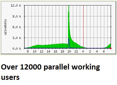
18 Main evening news of the Czech TV
19 Biggest Consumers of Network Services Viewing Cadastre Application 23 % (run by ČÚZK since 2004 the most frequently visited governmental web page) Ikatastr mobile Application 6% Other ČÚZK branch applications 3% Utilities Projections and engineering companies Municipalities and Regions Banks Environmental purposes

20 Use-cases (How to search use-cases of anonymous users?) Generally we get IP addresses only. Some applications contain links to the web pages, from which our network services were accessed. During January thousand such pages were monitored. Following use-cases are based on this list (selected open applications).

21

22 Open Street Map contributors
23
24

25 Municipality Žamberk

26 National Heritage Institute
27 Cenia

28 Institute of Forest Management

29 Safe Trees s.r.o.

30 Cieszyn Geoportal
31 Conclusion Running free and on-line INSPIRE network services brings specific challenge. It is difficult to use free services for guaranteed applications. The real need of view services is much higher than the defined INSPIRE parameters. INSPIRE extensions is the right way to bring INSPIRE and national services together. ČÚZK used INSPIRE implementation as a chance to build up infrastructure for providing spatial data with respect to the end-user.

32 Happy User Concept
33 Thank you for your attention Stránka 33
INSPIRE implementation as a link between egovernment and environmental purposes
 INSPIRE implementation as a link between egovernment and environmental purposes Jiří Poláček Czech Office for Surveying, Mapping and Cadastre (ČÚZK) Agenda Role of ČÚZK branch in the INSPIRE implementation.
CadastralparcelsforINSPIRE. Jiří Poláček
 CadastralparcelsforINSPIRE Jiří Poláček What sto come Digitization of cadastral maps in the Czech republic Workflow Description of services Challenges to be solved Implementation topics to be addressed
INSPIRE, GDPR and the Czech Real Estate Cadastre. Jiří Poláček Czech Office for Surveying, Mapping and Cadastre (ČÚZK)
") INSPIRE, GDPR and the Czech Real Estate Cadastre Jiří Poláček Czech Office for Surveying, Mapping and Cadastre (ČÚZK) Agenda GDPR principles Source data information systems and workflow GDPR and INSPIRE
INSPIRE, GDPR and the Czech Real Estate Cadastre Jiří Poláček Czech Office for Surveying, Mapping and Cadastre (ČÚZK) Agenda GDPR principles Source data information systems and workflow GDPR and INSPIRE
Recent development in Land Administration in the Czech Republic
 Recent development in Land Administration in the Czech Republic Contribution to discussion prepared by the Czech delegation 5th session of UNECE WPLA Item 3 of agenda Geneva, 19-20 November 2007 Czech
Cadastral Parcels in the context of INSPIRE
 Cadastral Parcels in the context of INSPIRE Gyula IVÁN Institute of Geodesy, Cartography & Remote Sensing, HUNGARY Open Symposium on Environment and Land Administration Big Works for the Defence of Territory
National Spatial Data Infrastructure development in Republic of Macedonia
 National Spatial Data Infrastructure development in Republic of Macedonia Sonja Dimova, state advisor for geomatics AGENCY FOR REAL ESTATE CADASTRE September 6-th, 2017, Strasbourg AREC competence for
DOWNLOAD ATOM SERVICES Cadastral Parcel (CP) Addresses (AD) Buildings (BU)
 Addresses (AD) Buildings (BU)") DOWNLOAD ATOM SERVICES Cadastral Parcel (CP) Addresses (AD) Buildings (BU) Version 1.0 July 2016 1 1 Description of ATOM Services... 3 2 Metadatos de los servicios... 3 3 Download ATOM services technical
DOWNLOAD ATOM SERVICES Cadastral Parcel (CP) Addresses (AD) Buildings (BU) Version 1.0 July 2016 1 1 Description of ATOM Services... 3 2 Metadatos de los servicios... 3 3 Download ATOM services technical
Annual Report Of the Czech Office for Surveying, Mapping and Cadastre For 2016
 Annual Report Of the Czech Office for Surveying, Mapping and Cadastre For 2016 Prague, 2017 1 CONTENT Introduction 1. Surveying, Mapping and Cadastre Sector in the Czech Republic 2. Administration of the
Czech Office for Surveying, Mapping and Cadastre. Annual Report
 Czech Office for Surveying, Mapping and Cadastre Annual Report 2011 Content Introduction 2 1. Surveying, Mapping and Cadastre Sector in the Czech Republic 4 2. Administration of the Cadastre of Real Estates
The French geoportal for Spatial plan (Géo-portail de l urbanisme): a spin-off of INSPIRE?
: a spin-off of INSPIRE?") The French geoportal for Spatial plan (Géo-portail de l urbanisme): a spin-off of INSPIRE? François Salgé - 1 - Content What is the Géoportail de l urbanisme Challenges for continuous and distributed updating
The French geoportal for Spatial plan (Géo-portail de l urbanisme): a spin-off of INSPIRE? François Salgé - 1 - Content What is the Géoportail de l urbanisme Challenges for continuous and distributed updating
Status and Perspectives of the Geodesy, Cartography and Cadastre Authority Availability of Geographic Information in Slovakia.
 Status and Perspectives of the Geodesy, Cartography and Cadastre Authority Availability of Geographic Information in Slovakia Hedviga Májovská Geodesy, Cartography and Cadastre Authority of the Slovak
INSPIRE Thematic Working. Cadastral parcels. September 2008
 INSPIRE Thematic Working Cadastral parcels September 2008 The INSPIRE context The INSPIRE Directive Its aim is to build the INfrastructure for Spatial InfoRmation in Europe The INSPIRE Directive has been
Cadastre and Other Public Registers: Multipurpose Cadastre or Distributed Land Information System?
 Cadastre and Other Public Registers: Multipurpose Cadastre or Distributed Land Information System? Ivan PESL, Czech Republic Key words: Cadastre, Land Registry, Property, Taxes, Land Use, Territorial Planning,
AREC responsibilities, data and registries and the way of their distribution
 Data as a basis of the digital society PCC, 13-15 March 2018, Sofia AREC responsibilities, data and registries and the way of their distribution Vlatko Dimovski Agency for Real Estate Cadastre (AREC) the
Challenges for the multi purpose cadastre
 Jens RIECKEN, Markus SEIFERT, Germany Key words: Multi purpose cadastre, 3d-cadastre, land use, SDI, solar cadastre SUMMARY Over the past 30 years, with the progress of information technologies the development
Annual Report Of the Czech Office for Surveying, Mapping and Cadastre For 2017
 Annual Report Of the Czech Office for Surveying, Mapping and Cadastre For 2017 Prague, 2018 1 CONTENT Introduction 1. Surveying, Mapping and Cadastre Sector in the Czech Republic 2. Administration of the
Cadastre and Land Registration in Europe
 Annex A: Questionnaire 2007 for Information Resource Cadastre and Land Registration in Europe Introduction This questionnaire is based on the EuroGeographics vision document 'Cadastre and Land Registration
Cadastral services and virtual office in e-cadastre
 Cadastral services and virtual office in e-cadastre Priit Kuus Estonian Land Board October 26, 2016 Coimbra Scope of data Cadastral parcels (as of September 2016) 674 383 cadastral parcels, i.e. 97,7 %
Utility networks in Estonian Restrictions Information
 Utility networks in Estonian Restrictions Information System Mr. Priit Kuus Department of Land Cadastre priit.kuus@maaamet.ee +372 675 0843 Tallinn 2011 Restrictions: legal grounds The Constitution of
Report and update from Working Group A on Core Data
 JOINT UN-GGIM: EUROPE ESS MEETING ON THE INTEGRATION OF STATISTICAL AND GEOSPATIAL INFORMATION LUXEMBOURG 31 MARCH 2017 Report and update from Working Group A on Core Data François Chirié, Dominique Laurent,
Digitalisation of the Real Property Rights Towards Spatially enabled E-Government
 Digitalisation of the Real Property Rights Towards Spatially enabled E-Government Lise Schroeder, Bent Hulegaard Jensen, Esben Munk Soerensen & Line Hvingel Istanbul, Turkey 25 june 201 Overview Introduction
Croatian SDI: a Tool for Accelerated Development of the Geo-Conscious Society
 STATE GEODETIC ADMINISTRATION Croatian SDI: a Tool for Accelerated Development of the Geo-Conscious Society Prof.Dr.Sc. Željko Bačić, Mr.Sc. Ljerka Rašić FIG Working Week 2009 - Surveyors Key Role in Accelerated
Recent Developments in Use and Dissemination of Geospatial Data in Germany - Example Lower Saxony
 Recent Developments in Use and Dissemination of Geospatial Data in Germany - Example Lower Saxony Conference Permanent Committee on Cadastre Lithuanian Presidency Vilnius, 22 October 2013 Peter Creuzer
The Multi-Purpose Information System of Real Estates in the Czech Republic. Vladimíra ŽUFANOVÁ, Czech Republic
 The Multi-Purpose Information System of Real Estates in the Czech Republic Vladimíra ŽUFANOVÁ, Czech Republic Key words: Cadastre; Land management SUMMARY The Cadastre of Real Estate and Land administration,
Amalia Velasco Carlos Alonso Luis Virgos Fernando Serrano
 Inspire services of the Spanish Directorate General for Cadastre and its use to resolve an old problem of coordination between Spanish Cadastre and Land Registry. Amalia Velasco Carlos Alonso Luis Virgos
GAUSSCAD A WEBGIS APPLICATION FOR COLLECTING CADASTRAL DATA
 M.M. Moise GaussCAD a WebGIS Application for Collecting Cadastral Data GAUSSCAD A WEBGIS APPLICATION FOR COLLECTING CADASTRAL DATA Mihai-Mircea MOISE, S.C. GAUSS S.R.L., mihai.moise@gauss.ro Abstract:
Role of National CLR Systems in the ELF-Cadastre Project. Amalia Velasco Martín-Varés Dirección General del Catastro. Spain
 Bratislava 2016 Role of National CLR Systems in the ELF-Cadastre Project Amalia Velasco Martín-Varés Dirección General del Catastro. Spain Bratislava 2016 Role of National CLR Systems in the ELF-Cadastre
LIS a motivation for SDI initiative
 Eric Mwaikambo Ardhi University Dar es Salaam Tanzania Overview Status of LIS in Tanzania Relationship between SDI and LIS Spatial Standards LIS a motivation for SDI initiative Conclusion & Recommendations
Cadastral Parcels in INSPIRE. Lisbon, 27 February 2013
 Cadastral Parcels in INSPIRE Lisbon, 27 February 2013 Dominique.laurent@ign.fr Plan INSPIRE context The modeling approach for theme Cadastral Parcels Implementation of INSPIRE theme Cadastral Parcels Context
Advances in Modern Land Administration Cadastre 2014 in the Year 2006
 Advances in Modern Land Administration Cadastre 2014 in the Year 2006 Winfried HAWERK, Germany Key words: E-Land Administration, IT renewal strategies SUMMARY FIG Commission 7 Working Group 7.3 deals with
Use of data in Ukraine for sustainable economic growth. Oleksandr Maliuk State Service of Ukraine for Geodesy, Cartography and Cadastre
 Use of data in Ukraine for sustainable economic growth Oleksandr Maliuk State Service of Ukraine for Geodesy, Cartography and Cadastre Kehl, 2017 Content of the presentation Ukraine & StateGeoCadastre:
International funding projects in Republic Geodetic Authority
 International funding projects in Republic Geodetic Authority Serbia: Republic Geodetic Authority Workshop Exploring Funding Instruments for NMCA 7-8 November 2012 Republic Geodetic Authority Republic
Egyptian Nationwide Title Cadastre System
 Kholoud SAAD, Egypt Key words: Cadastre, Registration, Urban, Rural, National Cadastre, Automation, reengineering. SUMMARY With growing need for integrated information, Enterprise Solutions has become
Spatial Data Infrastructure in Sweden
 Spatial Data Infrastructure in Sweden Hans-Erik WIBERG, Sweden Key words: ABSTRACT Sweden was one of the first countries to address Data Infrastructure matters and have during several decades developed
Unified Land Administration for a Better Spatial Infrastructure
 Unified Land Administration for a Better Spatial Infrastructure Gyula IVÁN Institute of Geodesy, Cartography & Remote Sensing FÖMI (HUNGARY) Open Symposium 30th Korean Cadastral Seminar & FIG Commission
Marine Spatial Data Infrastructure (MSDI) & The Marine Cadastre Application. April 10, 2018
 & The Marine Cadastre Application. April 10, 2018") Marine Spatial Data Infrastructure (MSDI) & The Marine Cadastre Application April 10, 2018 A Collaborative Pilot Project Vision of CHS: A framework of geographic data, metadata, users and tools Intent
Marine Spatial Data Infrastructure (MSDI) & The Marine Cadastre Application April 10, 2018 A Collaborative Pilot Project Vision of CHS: A framework of geographic data, metadata, users and tools Intent
New Danish e-cadastre and its role in the Danish e-government
 New Danish e-cadastre and its role in the Danish e-government PCC Budapest 2011 Pia Dahl Højgaard, pdh@kms.dk Cadastre and Legal Authority, National Survey and Mapping, Denmark The danish context Neighbours
Surveyors Qualifications
 Surveyors Qualifications Præludium Surveyors Qualifications Lars Jansson, Director Lantmäteriet Henning Elmstrøm, President DdL 1 Agenda 1. Introduction 2. Basic framework conditions for cadastral systems
The Challenge to Implement International Cadastral Models Case Finland 1
 The Challenge to Implement International Cadastral Models Case Finland 1 Tarja MYLLYMÄKI and Tarja PYKÄLÄ, Finland Key words: cadastre, modelling, LADM, INSPIRE SUMMARY Efforts are currently made to develop
Functional system for cadastral plans
 , Republic of Macedonia Key words: Cadastre, Digital plans, Data, System SUMMARY The analysis shows that the real estate market in Republic of Macedonia grows daily. With the expansion of this market increases
Land and Geographic Information, an Important Part of the Infrastructure in Sweden
 Land and Geographical Information Land and Geographic Information, an Important Part of the Infrastructure in Sweden Land and Geographic Information, an Important Part of the Infrastructure In Sweden Bo
COOPERATION BETWEEN PUBLIC AND PRIVATE SECTOR - PROJECT OF DIGITALIZATION OF THE CADASTRAL MAPS IN THE CZECH REPUBLIC
 COOPERATION BETWEEN PUBLIC AND PRIVATE SECTOR - PROJECT OF DIGITALIZATION OF THE CADASTRAL MAPS IN THE CZECH REPUBLIC Keywords: Cadastre of Real Estate, Czech Office for Surveying, Mapping and Cadastre
Quality Improvement of the Real Estate Cadastre in Serbia
 , Serbia Key words: quality improvement, real estate information, quality assurance, Serbia SUMMARY The concept of cadastral modernization in the Republic of Serbia was defined in 1992, and it is being
Towards LADM country cadastral profile case Poland
 Towards LADM country cadastral profile case Poland Jarosław Bydłosz Department of Geomatics Faculty of Mining Surveying and Environmental Engineering International FIG workshop on the Land Administration
The principal tasks or competencies of the General Directorate of Cadastre are:
 4th Quality Conference 1/7 1) Title of the case. Spanish e Cadastre ( Virtual Office of Cadastre, or OVC). An open space for sustainable quality in cadastral data, working with land management administrations.
Estonian e-cadastre as basis for efficient land management
 Estonian e-cadastre as basis for efficient land management Priit Kuus Estonian Land Board November 14, 2017 Tallinn Scope of data Cadastral parcels (as of October 2017) 693 026 cadastral parcels, i.e.
Serbia Should Have Online Cadastre for Property Like Other Countries in the Region
 Serbia Should Have Online Cadastre for Property Like Other Countries in the Region Tamara Borovcanin USAID Business Enabling Project The online real estate registry allows citizens to quickly and easily
The Development Strategy for Cadastre and Land Register in Finland
 1 2 The Development Strategy for and Land in Finland Arvo Kokkonen Ministry of Agriculture and Forestry Facts and figures of Finland - land area 304 530 km² - water area 33 615 km² - total area 338 195
Cadastral data services in Estonia
 Cadastral data services in Estonia Mr. Priit Kuus Department of Land Cadastre priit.kuus@maaamet.ee +372 675 0843 Ventspils 2013 Cadastre today Land Cadastre Act Adopted on 12 Oct.1994, since then amended
Challenge to Implement International Cadastral Models Case Finland
 FIG Articleof the Month April 20 Challenge to Implement International Cadastral Models Case Finland Tarja Myllymäki and Tarja Pykälä 200-04-5 The topics are In European level INSPIRE Experiences, similarities,
LAND CADASTRE AND BUILDING CADASTRE IN SLOVENIA: CURRENT SITUATION AND POTENTIAL OF 3D DATA
 3D Cadastres Organizational and Governmental Aspects LAND CADASTRE AND BUILDING CADASTRE IN SLOVENIA: CURRENT SITUATION AND POTENTIAL OF 3D DATA EMA POGORELČNIK AND MARINA KOROŠEC Surveying and Mapping
Large scale maps from Regions point of view. RNDr. Ivo Skrášek Head of IT department Zlín Region
 Large scale maps from Regions point of view RNDr. Ivo Skrášek Head of IT department Zlín Region Table of Content 1.Short characteristic of Digital cadastral map and Digital technical map 2. Experience
Latest Developments in Spanish Cadastral Services to citizens and administrations
 Latest Developments in Spanish Cadastral Services to citizens and administrations Amalia Velasco Martín-Varés, Coordinadora de Relaciones Internacionales Dirección General del Catastro 1/68 Leitmotiv of
Parcel Boundaries in the Czech Republic
 Parcel Boundaries in the Czech Republic CZECH REPUBLIC Jiri Rydval, Libor Tomandl Czech Office for Surveying, Mapping and Cadastre inhabitants - 10.3 million territory 78,865 km 2 2 Contents: 1. A parcel
The (Legal) Reliability of the Cadastre from the Perspective of the Czech Republic. Mgr. Martina Hercegová Ing. Karel Štencel
 Reliability of the Cadastre from the Perspective of the Czech Republic. Mgr. Martina Hercegová Ing. Karel Štencel") The (Legal) Reliability of the Cadastre from the Perspective of the Czech Republic Mgr. Martina Hercegová Ing. Karel Štencel PCC - Conference Vienna 20. 21. 11. 2018 Basic information about the CR Area:
The (Legal) Reliability of the Cadastre from the Perspective of the Czech Republic Mgr. Martina Hercegová Ing. Karel Štencel PCC - Conference Vienna 20. 21. 11. 2018 Basic information about the CR Area:
BULGARIAN CADASTRE A GUARANTEE FOR THE OWNERSHIP RIGHTS IN IMMOVABLE PROPERTIES
 4 TH INTERNATIONAL CONFERENCE RECENT PROBLEMS IN GEODESY AND RELATED FIELDS WITH INTERNATIONAL IMPORTANCE February 28 - March 2, 2007, Inter Expo Centre, Sofia, Bulgaria BULGARIAN CADASTRE A GUARANTEE
LADM in the Republic of Croatia making and testing country profile
 STATE GEODETIC ADMINISTRATION Gruška 20,10 000 Zagreb, Croatia LADM in the Republic of Croatia making and testing country profile Nikola Vučić Danko Markovinović Blaženka Mičević CONTENTS INTRODUCTION
WHAT IS NEW IN CADASTRE OF CZECH REPUBLIC. Libor Tomandl FIG Annual Meeting 2005, Madison
 WHAT IS NEW IN CADASTRE OF CZECH REPUBLIC Libor Tomandl FIG Annual Meeting 2005, Madison 1 Milestones of CzechCadastre 1993 -Establishment ofthe Czech Republic, -cadastral reform, Czech Cadastre of Real
Securing Land Rights for Broadband Land Acquisition for Utilities in Sweden
 Securing Land Rights for Broadband Land Acquisition for Utilities in Sweden Marija JURIC and Kristin LAND, Sweden Key words: broadband, land acquisition, cadastral procedure, Sweden SUMMARY The European
UTILITY CADASTER, ESTONIA
 Smeceres Smeceres UTILITY CADASTER, ESTONIA Mairolt Kakko CLGE, Association of Estonian Surveyors (EGÜ) 26.11.2015 CLGE Seminar, Zagreb LEGAL BASIS By the Estonian Building Act buildings are divided to
e-cadastre and Photo-Interpretation Technologies
 UNECE- WPLA EFFICIENT AND TRANSPARENT LAND MANAGEMENT IN ECE COUNTRIES 4 March 2010 - Baku, Azerbaijan e-cadastre and Photo-Interpretation Technologies The Italian experience as an example of Good Practice
City of Surrey s Digital Plan Submission Process
 City of Surrey s Digital Plan Submission Process Cadastral Update Karen Stewart, B.Tech. (GIS) Spatial Information Manager Peter Mueller, B.C.L.S., C.L.S. Survey Manager City of Surrey, British Columbia,
Ownership Data in Cadastral Information System of Sofia (CIS Sofia) from the Available Cadastral Map
 from the Available Cadastral Map") Ownership Data in Cadastral Information System of Sofia (CIS Sofia) from the Available Cadastral Map Key words: ABSTRACT Lydmila LAZAROVA, Bulgaria CIS Sofia is created and maintained by GIS Sofia ltd,
Ownership Data in Cadastral Information System of Sofia (CIS Sofia) from the Available Cadastral Map Key words: ABSTRACT Lydmila LAZAROVA, Bulgaria CIS Sofia is created and maintained by GIS Sofia ltd,
Strengths and Weaknesses of the Czech Cadastral System: An Analysis of Present System
 Strengths and Weaknesses of the Czech Cadastral System: An Analysis of Present System Jiri RYDVAL, Vaclav SLABOCH and Libor TOMANDL, Czech Republic Key words: Czech Republic, Cadastre, Historical Turnovers,
New Developments in the Hellenic Cadastre
 New Developments in the Hellenic Cadastre Prof. M. Kavouras Vice-president Ktimatologio S.A. (Hellenic Cadastre) The Hellenic Cadastre Background The Hellenic National Cadastre Organizational and institutional
The Land Information System
 Country report News from the Cadastre in Finland Ari Tella 24.10.2016 FIG Commission 7 Annual Meeting, Coimbra Portugal The Land Information System NLS 2010 Land 2013 Maintenance Information Service Customers
New Cadastral Mapping in the Czech Republic
 New Cadastral Mapping in the Czech Republic Karel Štencel, Svatava Dokoupilová, Jan Kmínek Czech Office for Surveying, Mapping and Cadastre Basic Data about the Czech Republic Area: 78 866 km 2 Population:
Building a European Spatial Data Infrastructure: The Role of EuroGeographics
 Building a European Spatial Data Infrastructure: The Role of EuroGeographics Richard Kirwan President of EuroGeographics 1st Congress on Cadastre in the EU 1 Presentation overview EuroGeographics - the
The Cadastre of Public-law Restrictions on Landownership in Switzerland
 The Cadastre of Public-law Restrictions on Landownership in Switzerland The new official land registry information system Maurice Barbieri, CLGE President Zagreb, 26.November 2015 Utility Cadastre Seminar
COMPUTERIZED SYSTEM SUPPORTING DEVELOPMENT OF LAND MARKET IN GEORGIA
 COMPUTERIZED SYSTEM SUPPORTING DEVELOPMENT OF LAND MARKET IN GEORGIA S. G. TSIRAMUA, I. S. MELASHVILI Land Registration Unit of Government of Georgian, World Bank and IFAD Agriculture Development Project.
Generic land administration business. FAO Workshop Rome, November 18-19,
 Generic land administration business FAO Workshop Rome, ovember 18-19, 2010 18.11.2010 1 Objectives Agree about what is the core land administration business common to all countries Derive the corresponding
Aspect of preliminary activities in the function of supporting NSDI
 Sonja DIMOVA, Republic of Macedonia Key words: e-governance, geospatial data, NSDI, INSPIRE, metadata SUMMARY The successful establishment of the NSDI in the true sense of the word cannot be performed
Presented at the FIG Working Week 2016, May 2-6, 2016 in Christchurch, New Zealand
 Presented at the FIG Working Week 2016, May 2-6, 2016 in Christchurch, New Zealand The IMPULS Project Is a Project About Cooperation, Coordination, Transparency and Data Sharing A SDI project in the Western
Republic of Bulgaria
 Geodesy, Cartography and Cadastre Agency Republic of Bulgaria www.cadastre.bg 24. 01. 2018 г., гр. София The Cadastre Legislation in Bulgaria - historical reference 1908 г. The Cadastre Act The objective
INTEGRATED LAND ADMINISTRATION SYSTEM PROJECT PREPARATION (IBRD Advance no. P459-HR) TERMS OF REFERENCE
 TERMS OF REFERENCE") INTEGRATED LAND ADMINISTRATION SYSTEM PROJECT PREPARATION (IBRD Advance no. P459-HR) TERMS OF REFERENCE SERVICE PROVISION FOR THE SUPPORT TO THE NATIONAL SPATIAL DATA INFRASTRUCTURE (NSDI) DEVELOPMENT
INTEGRATED LAND ADMINISTRATION SYSTEM PROJECT PREPARATION (IBRD Advance no. P459-HR) TERMS OF REFERENCE SERVICE PROVISION FOR THE SUPPORT TO THE NATIONAL SPATIAL DATA INFRASTRUCTURE (NSDI) DEVELOPMENT
Cadastre and Land Registration A System currently experiencing modernization in ROMANIA
 NATIONAL AGENCY FOR CADASTRE AND LAND REGISTRATION Mihai BUSUIOC Cadastre and Land Registration A System currently experiencing modernization in Agenda Historical Background Institutional organization
Croatian NSDI - An example of AGISEE country web-page. Vlado Cetl and Miljenko Lapaine
 Croatian NSDI - An example of AGISEE country web-page Vlado Cetl and Miljenko Lapaine Introduction 2/18 Guidelines AGISSE Country Pages should provide an overview of the situation of SDIs in the countries
PROTOCOL ASDI ARCTIC SPATIAL DATA INFRASTRUCTURE PROJECT KICK-OFF MEETING
 1(9) Friday, 15 October 2010 PROTOCOL ASDI ARCTIC SPATIAL DATA INFRASTRUCTURE PROJECT KICK-OFF MEETING Point of time: 09.00 October 14 11.15 October 15, 2010 Locality: Rue du Nord 76, 1000 Brussels, BELGIUM
Danish Multipurpose Cadastre Experiences so Far
 Danish Multipurpose Cadastre Experiences so Far Jørgen SKRUBBELTRANG, Denmark Key words: Multipurpose cadastre, restrictions pertaining to public law, new users, top down implementation, quality of the
New Technology for Cadastral Systems. Brent Jones, PE, PLS
 New Technology for Cadastral Systems Brent Jones, PE, PLS Benefits of Good Land Administration Key to addressing global challenges.. Secure Tenure Equitable Land and Property Taxation Support for Government
Building a national SDI. Approach and strategy in The Netherlands
 Agenda 1. NSDI vision and implementation strategy 2. NSDI playing field 3. Standards framework for the NSDI 4. National SDI components for IM Information model public safety SDI Portal for public safety
The Croatian Surveyor Guaranteeing Land Property
 Croatian Chamber of Chartered Geodetic Engineers Zagreb, Croatia www.hkoig.hr The Croatian Surveyor Guaranteeing Land Property Ph. D. Danko Markovinović The Cadastral Surveyor paving the Way to the Future
Using ArcGIS Server for National Property Information System
 Using ArcGIS Server for National Property Information System Shota Chachkhunashvili (National Agency of Public Registry, Georgia) Mikheil Tsiklauri (Geographic, Georgia) San Diego, 2008 About us National
Implementation Status & Results Croatia Integrated Land Administration System Project (P122219)
") Public Disclosure Authorized Public Disclosure Authorized The World Bank Implementation Status & Results Croatia Integrated Land Administration System Project (P122219) Operation Name: Integrated Land
Public Disclosure Authorized Public Disclosure Authorized The World Bank Implementation Status & Results Croatia Integrated Land Administration System Project (P122219) Operation Name: Integrated Land
NEW DEVELOPMENTS IN THE REAL PROPERTY REGISTER AND CADASTRE IN LITHUANIA
 NEW DEVELOPMENTS IN THE REAL PROPERTY REGISTER AND CADASTRE IN LITHUANIA Jaunius Grigas E-mail: jaunius.grigas@registrucentras.lt Verona, 2008 FUNCTIONS OF STATE ENTERPRISE CENTRE OF REGISTERS Registration
SECTOR PUBLIC CADASTRES AND REGISTERS MARKET PARTICIPANTS
 E-SERVICES TO CITIZENS, GOVERNMENT AND BUSINESSES. LITHUANIA EXPERIENCE Arvydas Bagdonavičius State Enterprise Centre of Registers Arvydas.Bagdonavicius@registrucentras.lt REGISTERS AND IS MANAGED BY THE
The Journey to 100% Electronic Survey. Land Information New Zealand. August 2009
 The Journey to 100% Electronic Survey and Title Lodgement Land Information New Zealand August 2009 Land Information New Zealand Established 1996 Titles, Survey, Geodetic, Electoral 12 locations 500 staff
Cadastre in Addis Ababa. Status and future development
 Status and future development Dr.-Ing. Paul Hartfiel Mülheim, 1. Oct. 2010-1 - Addis Ababa Capital of Ethiopia Area population 540 km² > 3,200,000 (rapidly growing) 2,300,000 in 1994 > 22% of all urban
KCA ORGANIZATION GOVERNMENT OF KOSOVA MINSTRY OF PUBLIC SERVICES GOVERNMENT OF KOSOVA MINSTRY OF PUBLIC SERVICES
 Development of Cadastre and Land Management in Kosovo Prof. Dr. sc. Murat Meha, chief executive Hyzri Llabjani-Cadastral Expert * Hajzer Bublaku-Lawyer FIG Working Week 2004 in Athens, Greece, May 22-27,
Addressing Land Sector Opportunities with Geospatial Information in Nepal
 The 20th UNRCC-AP and the 4th UN-GGIM-AP 5-10 October 2015 Jeju Island, Republic of Korea Addressing Land Sector Opportunities with Geospatial Information in Nepal Krishna Raj BC Executive Director Land
Cadastral PLSS Stewardship December 2010 Updated December 2013
 Cadastral PLSS Stewardship December 2010 Updated December 2013 Compiled by Bob Ader, Ben Knott, and Nancy von Meyer for the FGDC Cadastral Subcommittee Table of Contents 1. Overview... 2 2. Underlying
First Nations Land Registry
 First Nations Land Registry Making Sense of the ILRS Steven Patterson, Sitka Geomatics Inc. www.sitkageo.com Land Titles a brief history Land titles were traditionally managed within the community, and
Agenda Project Overview Project Objectives Registration Service Re-Engineering System Overview
 Agenda Project Overview Project Objectives Registration Service Re-Engineering System Overview Sydney, Australia, 11 16 April 2010 1 Project Overview Future Vision There is a vision within senior levels
The ISO/TC 211 Land Administration Domain Model (LADM)
") Geographic information/geomatics The ISO/TC 211 Land Administration Domain Model (LADM) Harry Uitermark/Editor LADM Kadaster/ITC, The Netherlands International Organization for Standardization (ISO) A
Geographic information/geomatics The ISO/TC 211 Land Administration Domain Model (LADM) Harry Uitermark/Editor LADM Kadaster/ITC, The Netherlands International Organization for Standardization (ISO) A
HOUSING AND PROPERTY MARKET IN LITHUANIA CONTENTS
 HOUSING AND PROPERTY MARKET IN LITHUANIA Kęstutis Sabaliauskas, Director General State Enterprise Centre of Registers, Lithuania Kestutis.Sabaliauskas@registrucentras.lt CONTENTS Legal environment Real
Enhancements of the Cadastral System in Switzerland
 Enhancements of the Cadastral System in Switzerland «Cadastre of Public-Law Restrictions on Landownership» and «National Utility Cadastre» Christoph Käser Content 1. Cadastre of Public-Law Restrictions
Building Integrated Land Information Systems and Development of NSDI
 Stig JÖNSSON, Sweden Key words: Land administration, land information systems, property formation, spatial data infrastructure, Inspire, institutional cooperation SUMMARY Lantmäteriet the Swedish agency
IMPACT OF REAL PROPERTY MARKET ON CHANGES OF CADASTRAL VALUE AND FORMATION OF SAMARA REGIONAL BUDGET
 IMPACT OF REAL PROPERTY MARKET ON CHANGES OF CADASTRAL VALUE AND FORMATION OF SAMARA REGIONAL BUDGET Gabibulla Khasaev 1, Dr.Sc., professor; Alexandr Vlasov 2, Cand.Sc., professor; Dariya Vasilieva 3,
Universal Geo-database Connector Interface Component (UG-CIC) For Virtual Web-base GIS Server Essential For Real Estate Industry Uses
 For Virtual Web-base GIS Server Essential For Real Estate Industry Uses") Universal Geo-database Connector Interface Component (UG-CIC) For Virtual Web-base GIS Server Essential For Real Estate Industry Uses Jad Jarroush & Dr. Kobi Zaid Zaid Orniv Group L.T.D Israel kobi_z@zaidorniv.co.il
Universal Geo-database Connector Interface Component (UG-CIC) For Virtual Web-base GIS Server Essential For Real Estate Industry Uses Jad Jarroush & Dr. Kobi Zaid Zaid Orniv Group L.T.D Israel kobi_z@zaidorniv.co.il
EXPANDING AVAILABILITY OF BROADBAND ACCESS AND ADOPTION
 Single point information Ilija Kepevski Agency for Electronic Communications Regional Conference for Europe EXPANDING AVAILABILITY OF BROADBAND ACCESS AND ADOPTION 28-29 September 2015 - Budva, Montenegro