Recent development in Land Administration in the Czech Republic
|
|
|
- Melvyn Stevens
- 5 years ago
- Views:
Transcription
1 Recent development in Land Administration in the Czech Republic Contribution to discussion prepared by the Czech delegation 5th session of UNECE WPLA Item 3 of agenda Geneva, November 2007
2 Czech Office for Surveying, Mapping and Cadastre COSMC is top governmental body for both Cadastre of Real Estates Single system, supported by information system 14 regional cadastral offices, 107 cadastral workplaces, 4847 employees, Surveying Land Survey Office - country wide competence, Geodetic control, State map series, surveying along state borders, ZABAGED basic GIS, network of permanent GPS stations,
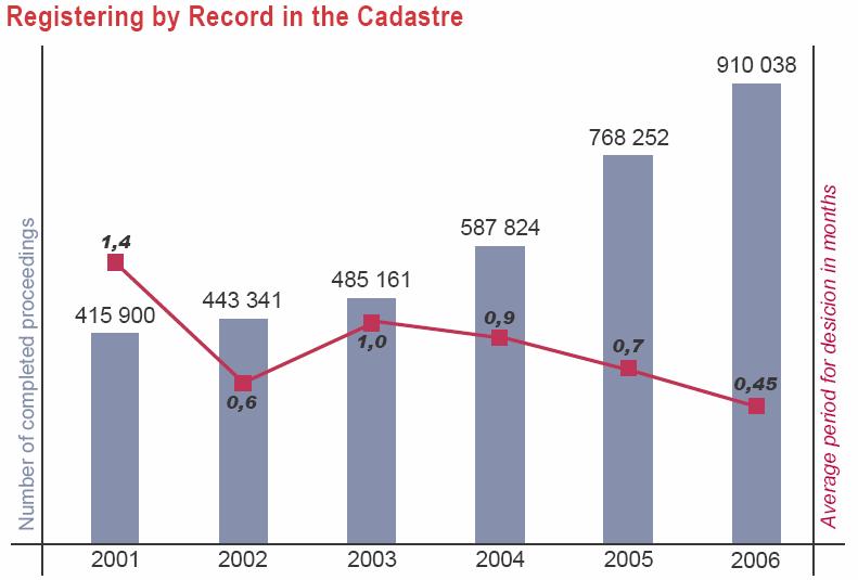
3 Administration of Czech Cadastre Main task of cadastral offices, core duties: Registering of rights by entries, records Provision of cadastral information Cadastral offices able to cope with these tasks, despite the huge increase in proceedings and the forced decrease in number of employees But it has influenced the slow progress in digitizing of cadastral maps and this delay causes obstacles for us as well as our clients

4
5
6
7 Digital cadastral maps Vectorized cadastral maps
8 Precautions for speeding up digitizing of cadastral maps Only 34% of cadastral units have been digitized Governmental decision in July 2007 COSMC will receive extra budget approx. 8,25 mil. EUR in each year % for temporary increase in employees 40% for private surveyors Increase in budgetary expenditures does not comply with the general policy of the government higher expenditures will be covered by an increase in cadastral fees Digitizing has to be completed by 2015
9 New structure of cadastral fees Current level among the lowest in Europe approx. 19 EUR per entry, not depending on the number of registered properties New structure the same amount for each property and each registered right Triple increase in cadastral fee for an average entry still quite affordable Amendments of laws under way, shall be effective from , discussions about the openness of cadastre Standardised forms for applications, both paper and electronic, will be implemented
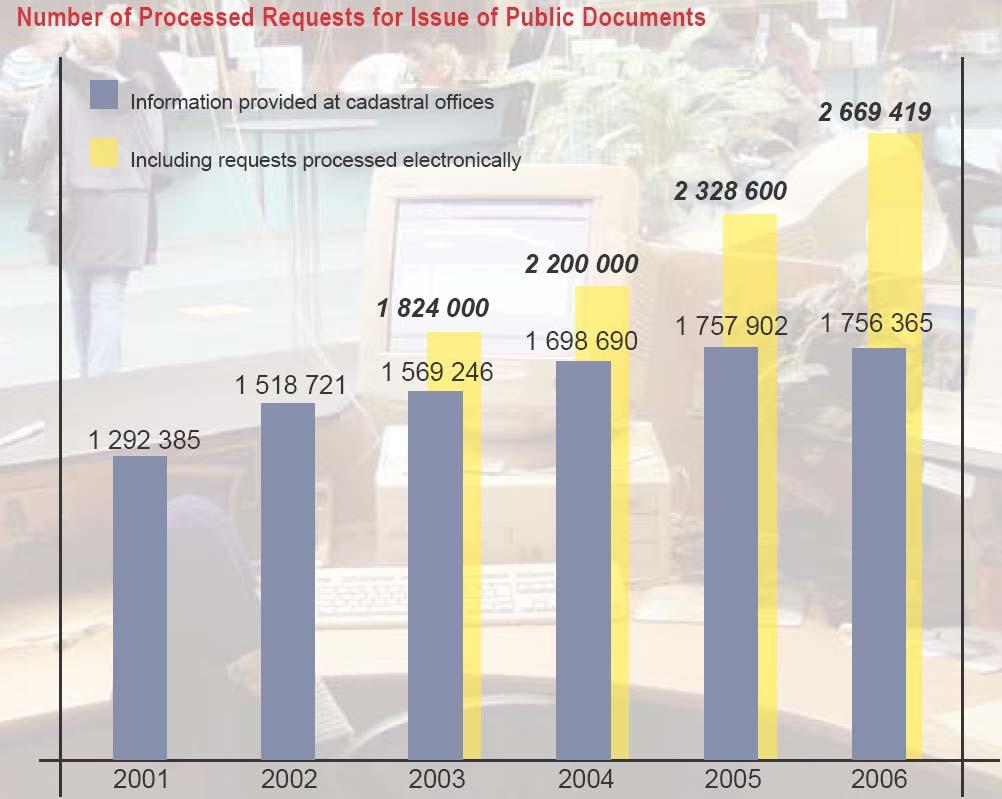
10 Information system of Czech Cadastre Uninterrupted run since 2001, including provision of information via internet New functions for clients of Remote Access Reference raster parcel maps Outputs with electronic signature Delivery of e-application by professional clients Web services for provision of some information Links to Czech POINTS (one-stop-shops) Centralisation of information system
11

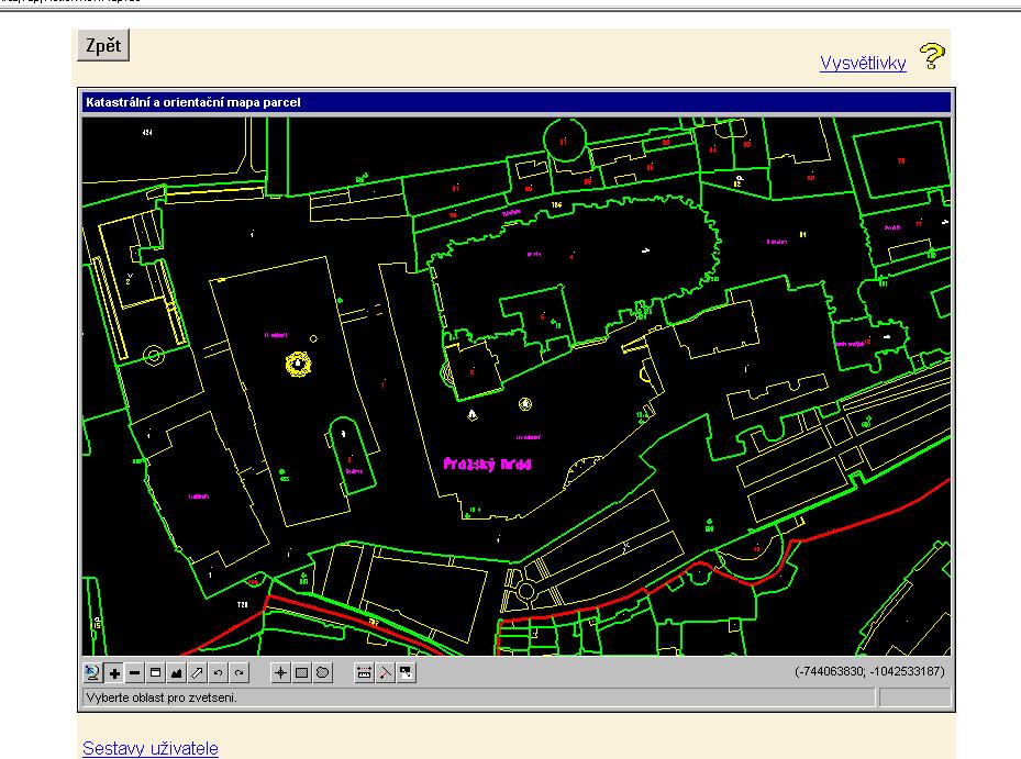
12 Mapové výstupy z DP ISKN orientační mapa parcel rastr+ ortofoto+ geometrické plány

13 Geoportal of Land Survey Office


14 CZEPOS Czech network of permanent GPS stations Created in years 2005 and stations build-up during the years
15 COSMC s data according to INSPIRE Directive Appendix I Coordinate reference systems Geographical grid systems Geographical names Administrative units Addresses Cadastral parcels Appendix II Elevations Orthoimagery Buildings Land use Appendix III
16 Role of COSMC in the implementation of INSPIRE COSMC - one of the key providers of data Will keep its GEOPORTAL, linked to National INSPIRE Portal, administered by Ministry of Interior Will cooperate in formulation of National Geodata Policy Transposition of INSPIRE to Czech legislation has been under way Pricing policy is subject of discussion Our position - only discovery services free of charge
17 Conclusions - main current and future tasks To maintain current positive trend in shortening of period of registering into Cadastre To complete digitizing of cadastral maps by 2015 To participate in the implementation of e- Government having the common goal: to improve services for citizens Incorporation of concept Czech POINTs together with governmental system for electronic delivery of documents, Register of territorial units, addresses and real estates, Step by step implementation of e-conveyancing

18 Thank you for your attention! Vít Suchánek Czech Office for Surveying, Mapping and Cadastre
INSPIRE implementation as a link between egovernment and environmental purposes
 INSPIRE implementation as a link between egovernment and environmental purposes Jiří Poláček Czech Office for Surveying, Mapping and Cadastre (ČÚZK) Agenda Role of ČÚZK branch in the INSPIRE implementation.
INSPIRE implementation as a link between egovernment and environmental purposes
 INSPIRE implementation as a link between egovernment and environmental purposes Jiří Poláček Czech Office for Surveying, Mapping and Cadastre (ČÚZK) What s to Come Role of ČÚZK branch in the INSPIRE implementation.
COOPERATION BETWEEN PUBLIC AND PRIVATE SECTOR - PROJECT OF DIGITALIZATION OF THE CADASTRAL MAPS IN THE CZECH REPUBLIC
 COOPERATION BETWEEN PUBLIC AND PRIVATE SECTOR - PROJECT OF DIGITALIZATION OF THE CADASTRAL MAPS IN THE CZECH REPUBLIC Keywords: Cadastre of Real Estate, Czech Office for Surveying, Mapping and Cadastre
HOUSING AND PROPERTY MARKET IN LITHUANIA CONTENTS
 HOUSING AND PROPERTY MARKET IN LITHUANIA Kęstutis Sabaliauskas, Director General State Enterprise Centre of Registers, Lithuania Kestutis.Sabaliauskas@registrucentras.lt CONTENTS Legal environment Real
Status and Perspectives of the Geodesy, Cartography and Cadastre Authority Availability of Geographic Information in Slovakia.
 Status and Perspectives of the Geodesy, Cartography and Cadastre Authority Availability of Geographic Information in Slovakia Hedviga Májovská Geodesy, Cartography and Cadastre Authority of the Slovak
ABSTRACT Land Administration System in Lithuania
 ABSTRACT Land Administration System in Lithuania 1. General introduction to the Lithuanian Land Administration System and State Enterprise Centre of Registers ( shortly SECR) Lithuania has established
Croatian SDI: a Tool for Accelerated Development of the Geo-Conscious Society
 STATE GEODETIC ADMINISTRATION Croatian SDI: a Tool for Accelerated Development of the Geo-Conscious Society Prof.Dr.Sc. Željko Bačić, Mr.Sc. Ljerka Rašić FIG Working Week 2009 - Surveyors Key Role in Accelerated
The Development of the Austrian Cadastre from Documentation to an Integrated Planning and Decision Support System
 The Development of the Austrian Cadastre from Documentation to an Integrated Planning and Decision Support System WPLA - Working Party on Land Administration 15-17 October 2014, Vienna, Austria Wernher
Czech Office for Surveying, Mapping and Cadastre. Annual Report
 Czech Office for Surveying, Mapping and Cadastre Annual Report 2011 Content Introduction 2 1. Surveying, Mapping and Cadastre Sector in the Czech Republic 4 2. Administration of the Cadastre of Real Estates
AREC responsibilities, data and registries and the way of their distribution
 Data as a basis of the digital society PCC, 13-15 March 2018, Sofia AREC responsibilities, data and registries and the way of their distribution Vlatko Dimovski Agency for Real Estate Cadastre (AREC) the
UNECE Working Party on Land Administration. Report on the Activities Carried Out by the UNECE WPLA Since the Committee's 72nd Session
 UNECE Working Party on Land Administration Report on the Activities Carried Out by the UNECE WPLA Since the Committee's 72nd Session Damir Pahic, dipl.ing. UNECE WPLA Chair 73rd Session 25th September
Cadastre and Other Public Registers: Multipurpose Cadastre or Distributed Land Information System?
 Cadastre and Other Public Registers: Multipurpose Cadastre or Distributed Land Information System? Ivan PESL, Czech Republic Key words: Cadastre, Land Registry, Property, Taxes, Land Use, Territorial Planning,
National Spatial Data Infrastructure development in Republic of Macedonia
 National Spatial Data Infrastructure development in Republic of Macedonia Sonja Dimova, state advisor for geomatics AGENCY FOR REAL ESTATE CADASTRE September 6-th, 2017, Strasbourg AREC competence for
International funding projects in Republic Geodetic Authority
 International funding projects in Republic Geodetic Authority Serbia: Republic Geodetic Authority Workshop Exploring Funding Instruments for NMCA 7-8 November 2012 Republic Geodetic Authority Republic
Land Administration In Public Private Partnerships
 Land Administration In Public Private Partnerships Workshop Customers - Co-operation - Services Vienna, 12-13 September 2002 Peter Creuzer Content Land Administration - Tasks History Spatial Data Infrastructure
Serbia Should Have Online Cadastre for Property Like Other Countries in the Region
 Serbia Should Have Online Cadastre for Property Like Other Countries in the Region Tamara Borovcanin USAID Business Enabling Project The online real estate registry allows citizens to quickly and easily
Quality Improvement of the Real Estate Cadastre in Serbia
 , Serbia Key words: quality improvement, real estate information, quality assurance, Serbia SUMMARY The concept of cadastral modernization in the Republic of Serbia was defined in 1992, and it is being
Annual Report Of the Czech Office for Surveying, Mapping and Cadastre For 2016
 Annual Report Of the Czech Office for Surveying, Mapping and Cadastre For 2016 Prague, 2017 1 CONTENT Introduction 1. Surveying, Mapping and Cadastre Sector in the Czech Republic 2. Administration of the
Use of data in Ukraine for sustainable economic growth. Oleksandr Maliuk State Service of Ukraine for Geodesy, Cartography and Cadastre
 Use of data in Ukraine for sustainable economic growth Oleksandr Maliuk State Service of Ukraine for Geodesy, Cartography and Cadastre Kehl, 2017 Content of the presentation Ukraine & StateGeoCadastre:
Implementation Status & Results Macedonia, former Yugoslav Republic of Real Estate Cadastre & Registration Project (P083126)
") Public Disclosure Authorized Public Disclosure Authorized Implementation Status & Results Macedonia, former Yugoslav Republic of Real Estate Cadastre & Registration Project (P083126) Operation Name: Real
Public Disclosure Authorized Public Disclosure Authorized Implementation Status & Results Macedonia, former Yugoslav Republic of Real Estate Cadastre & Registration Project (P083126) Operation Name: Real
Office for Government Representation in Property Affairs (OGRPA) MEMBER UPDATE
 MEMBER UPDATE") Office for Government Representation in Property Affairs (OGRPA) MEMBER UPDATE Annual Conference PuRE-net, Oslo, 25.- 28. 9. 2016 RE PROPERTY IN CZECH REPUBLIC & OGRPA Decentralized state RE ownership
Office for Government Representation in Property Affairs (OGRPA) MEMBER UPDATE Annual Conference PuRE-net, Oslo, 25.- 28. 9. 2016 RE PROPERTY IN CZECH REPUBLIC & OGRPA Decentralized state RE ownership
WHAT IS NEW IN CADASTRE OF CZECH REPUBLIC. Libor Tomandl FIG Annual Meeting 2005, Madison
 WHAT IS NEW IN CADASTRE OF CZECH REPUBLIC Libor Tomandl FIG Annual Meeting 2005, Madison 1 Milestones of CzechCadastre 1993 -Establishment ofthe Czech Republic, -cadastral reform, Czech Cadastre of Real
Tradition and Innovation in Czech Cadastre. Karel Večeře Martina Hercegová Jan Kmínek Czech Office for Surveying, Mapping and Cadastre
 Tradition and Innovation in Czech Cadastre Karel Večeře Martina Hercegová Jan Kmínek Czech Office for Surveying, Mapping and Cadastre Land Registration and Cadastre History 13 th cent. Land Tables - predecessor
Integration of Public Service Procedures and Use of Cadastral Data
 Integration of Public Service Procedures and Use of Cadastral Data Signe Rudzite Head of Cadastre and Register Department The State Land Service Vilnius, 21.10.2013 Content General information Current
Land and Geographic Information, an Important Part of the Infrastructure in Sweden
 Land and Geographical Information Land and Geographic Information, an Important Part of the Infrastructure in Sweden Land and Geographic Information, an Important Part of the Infrastructure In Sweden Bo
The Multi-Purpose Information System of Real Estates in the Czech Republic. Vladimíra ŽUFANOVÁ, Czech Republic
 The Multi-Purpose Information System of Real Estates in the Czech Republic Vladimíra ŽUFANOVÁ, Czech Republic Key words: Cadastre; Land management SUMMARY The Cadastre of Real Estate and Land administration,
Implementation Status & Results Croatia Integrated Land Administration System Project (P122219)
") Public Disclosure Authorized Public Disclosure Authorized The World Bank Implementation Status & Results Croatia Integrated Land Administration System Project (P122219) Operation Name: Integrated Land
Public Disclosure Authorized Public Disclosure Authorized The World Bank Implementation Status & Results Croatia Integrated Land Administration System Project (P122219) Operation Name: Integrated Land
Challenges for the multi purpose cadastre
 Jens RIECKEN, Markus SEIFERT, Germany Key words: Multi purpose cadastre, 3d-cadastre, land use, SDI, solar cadastre SUMMARY Over the past 30 years, with the progress of information technologies the development
Strengths and Weaknesses of the Czech Cadastral System: An Analysis of Present System
 Strengths and Weaknesses of the Czech Cadastral System: An Analysis of Present System Jiri RYDVAL, Vaclav SLABOCH and Libor TOMANDL, Czech Republic Key words: Czech Republic, Cadastre, Historical Turnovers,
Cadastre and Land Registration A System currently experiencing modernization in ROMANIA
 NATIONAL AGENCY FOR CADASTRE AND LAND REGISTRATION Mihai BUSUIOC Cadastre and Land Registration A System currently experiencing modernization in Agenda Historical Background Institutional organization
Implementation Status & Results Macedonia, former Yugoslav Republic of Real Estate Cadastre & Registration Project (P083126)
") Public Disclosure Authorized Public Disclosure Authorized Implementation Status & Results Macedonia, former Yugoslav Republic of Real Estate Cadastre & Registration Project (P083126) Operation Name: Real
Public Disclosure Authorized Public Disclosure Authorized Implementation Status & Results Macedonia, former Yugoslav Republic of Real Estate Cadastre & Registration Project (P083126) Operation Name: Real
DATR towards e-land Administration in Hungary
 DATR towards e-land Administration in Hungary Gyula IVÁN-Gábor SZABÓ-Zoltán WENINGER-Piroska Zalaba Institute of Geodesy, Cartography and Remote Sensing, Budapest, HUNGARY XXIV. FIG Congress Facing the
LAND ADMINISTRATION IN LITHUANIA: CHALLENGES AND PERSPECTIVES
 UNECE WPLA Workshop Influence of Land Administration on People and Business, Cavtat, Croatia, October 2-3, 2008 LAND ADMINISTRATION IN LITHUANIA: CHALLENGES AND PERSPECTIVES Kestutis Sabaliauskas, Director
Amie Figueiredo WPLA Secretariat Wednesday, 16 October 2014 Vienna, Raiffeisen Forum
 WPLA cooperation with related international organisations and interregional cooperation Amie Figueiredo WPLA Secretariat Wednesday, 16 October 2014 Vienna, Raiffeisen Forum International cooperation International
Recent Developments in Use and Dissemination of Geospatial Data in Germany - Example Lower Saxony
 Recent Developments in Use and Dissemination of Geospatial Data in Germany - Example Lower Saxony Conference Permanent Committee on Cadastre Lithuanian Presidency Vilnius, 22 October 2013 Peter Creuzer
Unified Land Administration for a Better Spatial Infrastructure
 Unified Land Administration for a Better Spatial Infrastructure Gyula IVÁN Institute of Geodesy, Cartography & Remote Sensing FÖMI (HUNGARY) Open Symposium 30th Korean Cadastral Seminar & FIG Commission
Functional system for cadastral plans
 , Republic of Macedonia Key words: Cadastre, Digital plans, Data, System SUMMARY The analysis shows that the real estate market in Republic of Macedonia grows daily. With the expansion of this market increases
Proposals for Best Practice
 WPLA Fees & Charges in Cadastre and Registration Proposals for Best Practice Neil King United Kingdom WPLA Fees and Charges Study Best Practice This presentation offers an overview of a draft report that
Aspect of preliminary activities in the function of supporting NSDI
 Sonja DIMOVA, Republic of Macedonia Key words: e-governance, geospatial data, NSDI, INSPIRE, metadata SUMMARY The successful establishment of the NSDI in the true sense of the word cannot be performed
REFORM OF LAND CADASTRE IN LITHUANIA
 REFORM OF LAND CADASTRE IN LITHUANIA Romualdas KASPERAVICIUS, Lithuania Key words: ABSTRACT Main aim for every Government is to create legal, financial and organisational circumstances for real property.
Country report, HUNGARY
 Country report, HUNGARY Gyula IVÁN Institute of Geodesy, Cartography & Remote Sensing (FÖMI) HUNGARY FIG Commission 7 Annual Meeting 2009 12-16 October, 2009, Kuala Lumpur, Malaysia Institute of Geodesy,
Recent Developments concerning Land Administration in Austria
 Recent Developments concerning Land Administration in Austria Main topics e-government reference data go online / egeodata Austria new pricing and licensing / business models INSPIRE / PSI / national infrastructure
Importance of Spatial Data Infrastructure in the UNECE Region. Amie Figueiredo INSPIRE Conference 2016 Barcelona, 26 September 2016
 Importance of Spatial Data Infrastructure in the UNECE Region. Amie Figueiredo INSPIRE Conference 2016 Barcelona, 26 September 2016 United Nations Economic Commission for Europe 56 member States in Europe,
Presented at the FIG Working Week 2016, May 2-6, 2016 in Christchurch, New Zealand
 Presented at the FIG Working Week 2016, May 2-6, 2016 in Christchurch, New Zealand The IMPULS Project Is a Project About Cooperation, Coordination, Transparency and Data Sharing A SDI project in the Western
Germany on the way to a 4D-Cadastre
 Germany on the way to a 4D-Cadastre Dr. Jens Riecken (DVW Vicepresident), Ulrich Gruber, Dr. Markus Seifert (DVW WG Geoinformation) TS 9.1 4D Cadastre, Land Domain Models & Concepts 1 Content About my
The Multipurpose Hungarian Unified Land Registry System
 The Multipurpose Hungarian Unified Land Registry System András Osskó FIG Working Week Integrating Generation Stockholm, Sweden 14-19 June 2008 Republic of Hungary is located in Central Europe Neighbouring
Advances in Modern Land Administration Cadastre 2014 in the Year 2006
 Advances in Modern Land Administration Cadastre 2014 in the Year 2006 Winfried HAWERK, Germany Key words: E-Land Administration, IT renewal strategies SUMMARY FIG Commission 7 Working Group 7.3 deals with
Annual Report Of the Czech Office for Surveying, Mapping and Cadastre For 2017
 Annual Report Of the Czech Office for Surveying, Mapping and Cadastre For 2017 Prague, 2018 1 CONTENT Introduction 1. Surveying, Mapping and Cadastre Sector in the Czech Republic 2. Administration of the
Implementation Status & Results Croatia Integrated Land Administration System Project (P122219)
") Public Disclosure Authorized Public Disclosure Authorized The World Bank Implementation Status & Results Croatia Integrated Land Administration System Project (P122219) Operation Name: Integrated Land
Public Disclosure Authorized Public Disclosure Authorized The World Bank Implementation Status & Results Croatia Integrated Land Administration System Project (P122219) Operation Name: Integrated Land
Cadastral Parcels in the context of INSPIRE
 Cadastral Parcels in the context of INSPIRE Gyula IVÁN Institute of Geodesy, Cartography & Remote Sensing, HUNGARY Open Symposium on Environment and Land Administration Big Works for the Defence of Territory
Report and update from Working Group A on Core Data
 JOINT UN-GGIM: EUROPE ESS MEETING ON THE INTEGRATION OF STATISTICAL AND GEOSPATIAL INFORMATION LUXEMBOURG 31 MARCH 2017 Report and update from Working Group A on Core Data François Chirié, Dominique Laurent,
The French geoportal for Spatial plan (Géo-portail de l urbanisme): a spin-off of INSPIRE?
: a spin-off of INSPIRE?") The French geoportal for Spatial plan (Géo-portail de l urbanisme): a spin-off of INSPIRE? François Salgé - 1 - Content What is the Géoportail de l urbanisme Challenges for continuous and distributed updating
The French geoportal for Spatial plan (Géo-portail de l urbanisme): a spin-off of INSPIRE? François Salgé - 1 - Content What is the Géoportail de l urbanisme Challenges for continuous and distributed updating
UNECE workshop on: Cadastral and real estate registration systems: Economic information for real estate markets in the UNECE region
 UNECE workshop on: Cadastral and real estate registration systems: Economic information for real estate markets in the UNECE region Roma, 5-65 6 May 2011 Maurizio Festa Agenzia del Territorio Head of Statistics
INTEGRATED LAND ADMINISTRATION SYSTEM PROJECT PREPARATION (IBRD Advance no. P459-HR) TERMS OF REFERENCE
 TERMS OF REFERENCE") INTEGRATED LAND ADMINISTRATION SYSTEM PROJECT PREPARATION (IBRD Advance no. P459-HR) TERMS OF REFERENCE SERVICE PROVISION FOR THE SUPPORT TO THE NATIONAL SPATIAL DATA INFRASTRUCTURE (NSDI) DEVELOPMENT
INTEGRATED LAND ADMINISTRATION SYSTEM PROJECT PREPARATION (IBRD Advance no. P459-HR) TERMS OF REFERENCE SERVICE PROVISION FOR THE SUPPORT TO THE NATIONAL SPATIAL DATA INFRASTRUCTURE (NSDI) DEVELOPMENT
Cadastral services and virtual office in e-cadastre
 Cadastral services and virtual office in e-cadastre Priit Kuus Estonian Land Board October 26, 2016 Coimbra Scope of data Cadastral parcels (as of September 2016) 674 383 cadastral parcels, i.e. 97,7 %
BULGARIAN CADASTRE A GUARANTEE FOR THE OWNERSHIP RIGHTS IN IMMOVABLE PROPERTIES
 4 TH INTERNATIONAL CONFERENCE RECENT PROBLEMS IN GEODESY AND RELATED FIELDS WITH INTERNATIONAL IMPORTANCE February 28 - March 2, 2007, Inter Expo Centre, Sofia, Bulgaria BULGARIAN CADASTRE A GUARANTEE
Development of e-land Administration in Sweden
 Development of e-land Administration in Sweden Roger EKMAN, Sweden Key words: e-land Administration, e-cadastre, delivery times, process development SUMMARY A characteristic of the Swedish cadastral procedure
Croatian NSDI - An example of AGISEE country web-page. Vlado Cetl and Miljenko Lapaine
 Croatian NSDI - An example of AGISEE country web-page Vlado Cetl and Miljenko Lapaine Introduction 2/18 Guidelines AGISSE Country Pages should provide an overview of the situation of SDIs in the countries
Annual Meeting 2006 SLOVENIA, BLED RASAS GOFMANAS JAUNIUS GRIGAS RIMANTAS RAMANAUSKAS KESTUTIS TRECIOKAS
 Annual Meeting 2006 SLOVENIA, BLED LAND ADMINISTRATION IN LITHUANIA RASAS GOFMANAS JAUNIUS GRIGAS RIMANTAS RAMANAUSKAS KESTUTIS TRECIOKAS ADMINISTRATIVE STRUCTURE OF LITHUANIA HISTORY OF LAND ADMINISTRATION
The principal tasks or competencies of the General Directorate of Cadastre are:
 4th Quality Conference 1/7 1) Title of the case. Spanish e Cadastre ( Virtual Office of Cadastre, or OVC). An open space for sustainable quality in cadastral data, working with land management administrations.
Building a European Spatial Data Infrastructure: The Role of EuroGeographics
 Building a European Spatial Data Infrastructure: The Role of EuroGeographics Richard Kirwan President of EuroGeographics 1st Congress on Cadastre in the EU 1 Presentation overview EuroGeographics - the
FIG Commission 3 Spatial Information Management. Report of Activities 2009
 Appendix to item 10.3 Report to the 33 rd General Assembly FIG Congress in Sydney, Australia 2010 FIG Commission 3 Spatial Information Management Report of Activities 2009 1. General Since 2007, FIG Commission
Progress Report on Green Paper. Dr. Paddy Prendergast. on behalf of the. IIS Commission on Land Registration
 Progress Report on Green Paper By Dr. Paddy Prendergast on behalf of the IIS Commission on Land Registration Paddy Prendergast - Chair Brendan Sweeny - Hempenstall Surveys Paul Corrigan - P Corrigan Associates
Digitalisation of the Real Property Rights Towards Spatially enabled E-Government
 Digitalisation of the Real Property Rights Towards Spatially enabled E-Government Lise Schroeder, Bent Hulegaard Jensen, Esben Munk Soerensen & Line Hvingel Istanbul, Turkey 25 june 201 Overview Introduction
The Challenge to Implement International Cadastral Models Case Finland 1
 The Challenge to Implement International Cadastral Models Case Finland 1 Tarja MYLLYMÄKI and Tarja PYKÄLÄ, Finland Key words: cadastre, modelling, LADM, INSPIRE SUMMARY Efforts are currently made to develop
EVOLUTION TOWARDS THE DIGITAL LAND OFFICES
 EVOLUTION TOWARDS THE DIGITAL LAND OFFICES Szabolcs MIHÁLY, Piroska ZALABA Budapest, Hungary 1. INTRODUCTION 2. CURRENT STATUS OF THE UNIFORM LAND REGISTRATION 2.1. Management Features of the Hungarian
ISSUES OF EFFICIENCY IN PUBLIC REAL ESTATE RESOURCES MANAGEMENT
 Alina Zrobek-Rozanska (MSC) Prof. Ryszard Zrobek University of Warmia and Mazury in Olsztyn, Poland rzrobek@uwm.edu.pl alina.zrobek@uwm.edu.pl ISSUES OF EFFICIENCY IN PUBLIC REAL ESTATE RESOURCES MANAGEMENT
The Development Strategy for Cadastre and Land Register in Finland
 1 2 The Development Strategy for and Land in Finland Arvo Kokkonen Ministry of Agriculture and Forestry Facts and figures of Finland - land area 304 530 km² - water area 33 615 km² - total area 338 195
Directorate of Survey and Mapping NAMIBIA. Cadastral Information System. Vehupisa Kasuko Tjatindi Surveyor Directorate of Survey and Mapping NAMIBIA
 Vehupisa Kasuko Tjatindi Directorate of Survey and Mapping NAMIBIA Tel: +64 61 965000 Directorate of Survey and Mapping NAMIBIA Cadastral Information System Introduction Over the past few decades cadastral
Cadastre and Land Registration in Europe
 Annex A: Questionnaire 2007 for Information Resource Cadastre and Land Registration in Europe Introduction This questionnaire is based on the EuroGeographics vision document 'Cadastre and Land Registration
Large scale maps from Regions point of view. RNDr. Ivo Skrášek Head of IT department Zlín Region
 Large scale maps from Regions point of view RNDr. Ivo Skrášek Head of IT department Zlín Region Table of Content 1.Short characteristic of Digital cadastral map and Digital technical map 2. Experience
The (Legal) Reliability of the Cadastre from the Perspective of the Czech Republic. Mgr. Martina Hercegová Ing. Karel Štencel
 Reliability of the Cadastre from the Perspective of the Czech Republic. Mgr. Martina Hercegová Ing. Karel Štencel") The (Legal) Reliability of the Cadastre from the Perspective of the Czech Republic Mgr. Martina Hercegová Ing. Karel Štencel PCC - Conference Vienna 20. 21. 11. 2018 Basic information about the CR Area:
The (Legal) Reliability of the Cadastre from the Perspective of the Czech Republic Mgr. Martina Hercegová Ing. Karel Štencel PCC - Conference Vienna 20. 21. 11. 2018 Basic information about the CR Area:
Property Transactions in the Digital Age. The Property Cadastre in the Context of Spatial. Dr. Jens Riecken, NRW Ministry of the Interior
 Property Transactions in the Digital Age The Property Cadastre in the Context of Spatial Data Infrastructure (SDI) Dr. Jens Riecken, NRW Ministry of the Interior Property Transactions in the Digital Age
Parcel Boundaries in the Czech Republic
 Parcel Boundaries in the Czech Republic CZECH REPUBLIC Jiri Rydval, Libor Tomandl Czech Office for Surveying, Mapping and Cadastre inhabitants - 10.3 million territory 78,865 km 2 2 Contents: 1. A parcel
Spatial Data Infrastructure in Sweden
 Spatial Data Infrastructure in Sweden Hans-Erik WIBERG, Sweden Key words: ABSTRACT Sweden was one of the first countries to address Data Infrastructure matters and have during several decades developed
EXPANDING AVAILABILITY OF BROADBAND ACCESS AND ADOPTION
 Single point information Ilija Kepevski Agency for Electronic Communications Regional Conference for Europe EXPANDING AVAILABILITY OF BROADBAND ACCESS AND ADOPTION 28-29 September 2015 - Budva, Montenegro
UNECE Working Party on Land Administration UNECE WPLA. Report on the work of the Bureau of the Working Party
 UNECE Working Party on Land Administration UNECE WPLA Report on the work of the Bureau of the Working Party 10 th Session of UNECE WPLA Geneva, 8 9 March 2017 UNECE Working Party on Land Administration
Development of Market of Geodetic Services and Geodetic Companies in the Republic of Serbia
 FIG Working Week 2009 Development of Market of Geodetic Services and Geodetic Companies in the Republic of Serbia Zagorka GOSPAVIC, Branko BOZIC and Olivera VASOVIC The Faculty of Civil Engineering, Serbia
e-land Administration in Hungary
 e-land Administration in Hungary Piroska Zalaba senior counsellor, project manager Ministry of Agriculture and Rural Development Department of Lands and Mapping FIG SEMINAR Innsbruck, 2-4 June 2004 Land
The Survey Data Model Technology A practical survey solution to generate all levels of spatial and e-governance outcomes.
 Land Governance in a Rapidly Changing Environment Annual World Bank Conference on Land and Poverty April 24 & 25, 2012 The Survey Data Model Technology A practical survey solution to generate all levels
Designing for transparency and participation in the Hellenic Cadastral Project
 Designing for transparency and participation in the Hellenic Cadastral Project Dr. Dimitris Rokos Director of Planning and Investments, Hellenic National Cadastre and Mapping Agency S.A. Table of Contents
The Digital Cadastral Database and the Role of the Private Licensed Surveyors in Denmark
 IRISH INSTITUTE OF SURVEYORS, DUBLIN INSTITUTE OF TECHNOLOGY, 23 NOVEMBER 2005 PUBLISHED IN IIS NEWS, WINTHER 2006. The Digital Cadastral Database and the Role of the Private Licensed Surveyors in Denmark
Implementation Status & Results Macedonia, former Yugoslav Republic of Real Estate Cadastre & Registration Project (P083126)
") Public Disclosure Authorized Public Disclosure Authorized The World Bank Implementation Status & Results Macedonia, former Yugoslav Republic of Real Estate Cadastre & Registration Project (P083126) Operation
Public Disclosure Authorized Public Disclosure Authorized The World Bank Implementation Status & Results Macedonia, former Yugoslav Republic of Real Estate Cadastre & Registration Project (P083126) Operation
Italian Cadastre and Real Estate Rights and Mortgages Registration System
 CLGE General Assembly Italian Cadastre and Real Estate Rights and Mortgages Registration System Franco Maggio Central Director Cartography, Cadastre and Real Estate Rights and Mortgages Registration System
e-cadastre and Photo-Interpretation Technologies
 UNECE- WPLA EFFICIENT AND TRANSPARENT LAND MANAGEMENT IN ECE COUNTRIES 4 March 2010 - Baku, Azerbaijan e-cadastre and Photo-Interpretation Technologies The Italian experience as an example of Good Practice
SECTOR PUBLIC CADASTRES AND REGISTERS MARKET PARTICIPANTS
 E-SERVICES TO CITIZENS, GOVERNMENT AND BUSINESSES. LITHUANIA EXPERIENCE Arvydas Bagdonavičius State Enterprise Centre of Registers Arvydas.Bagdonavicius@registrucentras.lt REGISTERS AND IS MANAGED BY THE
KCA ORGANIZATION GOVERNMENT OF KOSOVA MINSTRY OF PUBLIC SERVICES GOVERNMENT OF KOSOVA MINSTRY OF PUBLIC SERVICES
 Development of Cadastre and Land Management in Kosovo Prof. Dr. sc. Murat Meha, chief executive Hyzri Llabjani-Cadastral Expert * Hajzer Bublaku-Lawyer FIG Working Week 2004 in Athens, Greece, May 22-27,
TERMS OF REFERENCE FOR CONSULTANCY SERVICES TO PREPARE PROJECT DOCUMENT FOR CADASTRAL MAPPING IN THE GAMBIA
 Ministry of Lands and Regional Government United Nations Development Program UNDP April 2017 TERMS OF REFERENCE FOR CONSULTANCY SERVICES TO PREPARE PROJECT DOCUMENT FOR CADASTRAL MAPPING IN THE GAMBIA
Actual Developments of Land Consolidation in Finland. Mikko UIMONEN, Finland
 Actual developments of land consolidation in Finland Mikko UIMONEN, Finland Key words: Land consolidation, Land rearrangement, Reallotment of parcels, Quality management SUMMARY This paper describes the
Hungarian practice of servicing cadastral information Piroska Zalaba senior counselor
 Hungarian practice of servicing cadastral information Piroska Zalaba senior counselor Ministry of Agriculture and Rural Development Department of Land Administration and Geoinformation Cadastre, Public
FIG Task Force on: Property and Housing
 International Federation of Surveyors Fédération Internationale des Géomètres International Vereinigung der Vermessungsingenieure FIG Task Force on: Property and Housing Chryssy Potsiou, Assist Prof, FIG
The Croatian Surveyor Guaranteeing Land Property
 Croatian Chamber of Chartered Geodetic Engineers Zagreb, Croatia www.hkoig.hr The Croatian Surveyor Guaranteeing Land Property Ph. D. Danko Markovinović The Cadastral Surveyor paving the Way to the Future
FEES AND CHARGES IN CROATIAN LAND ADMINISTRATION
 REPUBLIC OF CROATIA STATE GEODETIC ADMINISTRATION DGU FEES AND CHARGES IN CROATIAN LAND ADMINISTRATION Prof.dr.sc.Željko Bačić Director general UN ECE WPLA Sixth Session Geneva, June, 18-19, 2009 1 ORGANIZATIONAL
INSPIRE, GDPR and the Czech Real Estate Cadastre. Jiří Poláček Czech Office for Surveying, Mapping and Cadastre (ČÚZK)
") INSPIRE, GDPR and the Czech Real Estate Cadastre Jiří Poláček Czech Office for Surveying, Mapping and Cadastre (ČÚZK) Agenda GDPR principles Source data information systems and workflow GDPR and INSPIRE
INSPIRE, GDPR and the Czech Real Estate Cadastre Jiří Poláček Czech Office for Surveying, Mapping and Cadastre (ČÚZK) Agenda GDPR principles Source data information systems and workflow GDPR and INSPIRE
CadastralparcelsforINSPIRE. Jiří Poláček
 CadastralparcelsforINSPIRE Jiří Poláček What sto come Digitization of cadastral maps in the Czech republic Workflow Description of services Challenges to be solved Implementation topics to be addressed
CLGE Working for a Profession
 CLGE Working for a Profession 15. November 2017 Tallinn (ES) The public-private partnership in cadastre in Switzerland SWITZERLAND 41'290 km 2 8 million people 26 cantons ~2600 municipalities ~4.0 million
Integrated Land Information Services in Hungarian Land Administration
 , Hungary Key words: key words, theme, etc. SUMMARY The Unified Hungarian Land Registry, in which cadastral mapping and land registry belong to the same organization (Land Office Network), has been operating
Geoinformation Technologies in Land Management and Beyond: Case of Georgia
 Geoinformation Technologies in Land Management and Beyond: Case of Georgia Joseph SALUKVADZE Professor, Department of Human Geography, Co-team Leader, Cadastre and Land Register Project, Co-financed by
FGDC SUBCOMMITTEE FOR CADASTRAL DATA. October 2004 Albuquerque, New Mexico Meeting
 FGDC SUBCOMMITTEE FOR CADASTRAL DATA October 2004 Albuquerque, New Mexico Meeting The National Spatial Data Infrastructure is the means to assemble geographic information that describes the arrangements