APPENDIX D REAL ESTATE
|
|
|
- Edith White
- 5 years ago
- Views:
Transcription
1 APPENDIX D REAL ESTATE


2 American River Watershed Common Features General Reevaluation Report Real Estate Plan February
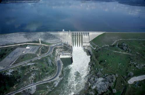
3 Cover Photos courtesy of the Sacramento District: Sacramento Weir during operation Sacramento River facing south near the Pocket and Little Pocket neighborhoods High flows on the American River at the Highway 160 overcrossing Folsom Dam releasing high flows 2
4 AMERICAN RIVER, CALIFORNIA COMMON FEATURES PROJECT GENERAL REEVALUATION REPORT Real Estate Plan U.S. Army Corps of Engineers Sacramento District February
5 TABLE OF CONTENTS 1. STATEMENT OF PURPOSE 2. PROJECT AUTHORITY 3. PROJECT DESCRIPTION 4. DESCRIPTION OF LERRD S 5. LERRD S OWNED BY THE NFS AND CREDITING 6. STANDARD FEDERAL ESTATES AND NON-STANDARD ESTATES 7. DESCRIPTION OF ANY EXISTING FEDERAL PROJECT IN OR PARTIALLY IN THE PROPOSED PROJECT 8. DESCRIPTION OF ANY FEDERALLY OWNED LAND NEEDED FOR THE PROJECT 9. APPLICATION OF NAVIGATIONAL SERVITUDE TO THE LERRD S REQUIREMENT 10. PROJECT MAP 11. ANTICIPATED INCREASED FLOODING AND IMPACTS 12. COST ESTIMATE 13. RELOCATION ASSISTANCE BENEFITS 14. MINERAL / TIMBER ACTIVITY 15. NON-FEDERAL SPONSOR S ABILITY TO ACQUIRE 16. ZONING ANTICIPATED IN LIEU OF ACQUISITION 17. ACQUISITION SCHEDULE 19. DESCRIPTION OF FACILITY AND UTILITY RELOCATIONS 20. HAZARDOUS, TOXIC, AND RADIOLOGICAL WASTE IMPACTS 21. ATTITUDE OF LANDOWNERS 22. CULTURAL RESOURCE SITES EXHIBIT A - ASSESSMENT OF NON-FEDERAL PARTNERS REAL ESTATE CAPABILITY EXHIBIT B- POLICY GUIDANCE LETTER 31 REAL ESTATE SUPPORT TO CIVIL WORKS PLANNING PARADIGM (3x3x3) EXHIBIT C WAIVER FOR PUBLICALLY OWNED UTILITIES AND FACILITIES EXHIBIT D - CADASTRAL MAP AND TRACT REGISTERS Cadastral Maps 2015 EXHIBIT E - UTILITY/FACILITY RELOCATION INVENTORY Utility-Facility Relocations EXHIBIT F - RELOCATION ASSISTANCE DRAFT PLAN RAP SAMPLE PLAN.pdf 4
6 REAL ESTATE PLAN For American River Watershed Common Features General Reevaluation Report Sacramento and Sutter Counties, California 1. Statement of Purpose This Real Estate Plan (REP) is intended to support and present the real estate requirements for a general reevaluation study of the authorized American River Common Features Project (ARCF) and is for planning purposes only. Studies that were completed prior to this reevalution report include the following: Congress directed the Corps to investigate additional means to reduce flood risk to the City of Sacramento following the flood of The Corps completed a feasibility study in 1991, recommending a concrete gravity flood detention dam at the Auburn Dam site and levee improvements downstream of Folsom Dam. Congress directed the Corps to conduct supplemental analysis of the flood control options considered in the 1991 study. The resulting Supplemental Information Report, American River Watershed Project, California (March 1996) recommended a similar combination of a gravity flood detention dam at the Auburn Dam site with downstream levee work. It considered, but did not advance, plans for Folsom Dam improvements and a stepped release plan for Folsom Dam accompanied by downstream levee improvements. Congress recognized that levee improvements were common to all candidate plans in the report and that there was a Federal interest in participating in these common features. Thus, the American River Common Features Project was authorized in Water Resource Development Act (WRDA) 1996 (Pub. L , Section 101(a)(1)) and the decision on Auburn Dam was deferred. Major construction components for Common Features included construction of levee improvements to reduce seepage along approximately 22 miles of American River levees, and levee strengthening and the raising of 12 miles of the Sacramento River levee in the Natomas Basin. Meanwhile, improvements to other levees adjacent to the Natomas Basin were authorized in the Defense Appropriations Act of 1993 (Pub. L , (HR 5504), Sec. 9159, 106 STAT. 1876, (1992)). The Sacramento Area Flood Control Agency (SAFCA) constructed these latter improvements between 1995 and In 1999, Congress authorized improvements to Folsom Dam to control a 200-year flood event with a peak release of 160,000 cubic feet per second. WRDA 1999 also authorized the Folsom Dam Modification Project to modify the existing outlets to allow for higher releases earlier in flood events. At the same time, Congress also directed the Corps to review additional modifications to the flood storage of Folsom Dam, indicating that Congress was looking at maximizing the use of Folsom Dam for flood damage reduction prior to consideration of any additional storage on the American River. The Folsom Dam Raise Project was subsequently authorized by Congress in The Common Features project was modified by WRDA 1999 so that it could safely convey an emergency release of 160,000 cfs. These improvements included construction of slurry walls to reduce seepage and levee raises along four stretches of the American River, and construction of levee strengthening and raising of 5.5 miles of the Natomas Cross Canal levee in the Natomas Basin. Additional construction components for both WRDA 1996 and 1999 were authorized, and are described in Chapter 5 of main GRR document. 5
7 All American River features authorized in WRDA 1996 and 1999 have been constructed by the Corps of Engineers or are in design analysis for construction within a year or two. Design and construction have been undertaken under a Project Cooperation Agreement with the California Reclamation Board (now known as the Central Valley Flood Protection Board (CVFPB)) executed July 13, 1998, and amended four times. Cost sharing for these features is 75% Federal and 25% non- Federal. However, the Natomas Basin features authorized in WRDA 1996 and 1999 have been deferred. Following the flood of 1986, significant seepage was experienced on the Sacramento River from Verona (upstream end of Natomas) at River Mile (RM) 79 to Freeport at RM 45.5 and on both the north and south bank of the American River. Seepage on the Sacramento River was so extensive that soon after the 1986 flood event, Congress funded levee improvements as part of the Sacramento Urban Levee Improvement Project (Sac Urban). The Sac Urban Project constructed shallow seepage cutoff walls from Powerline Road in Natomas down to the town of Freeport. At the time, seepage through the levees was considered to be the only significant seepage problem affecting the City of Sacramento. After construction of the Sac Urban project, the Sacramento Valley experienced a flood event in This led to a geotechnical evaluation of levees in the vicinity of the City of Sacramento which showed that deep underseepage was of concern. Considerable seepage occurred on the Sacramento River as well as on the American River. Seepage on the American River was expected because the levee improvements had not yet been constructed. However, the occurrence of significant seepage on the Sacramento River in the reach improved as part of the Sac Urban project confirmed that deep underseepage was a significant concern in this area, a conclusion later confirmed by the Levee Seepage Task Force in Following the recognition of deep underseepage as a major concern, seepage reduction measures on the American River needed to be redesigned to reduce both through- and deep underseepage. The redesign led to considerable cost increases over what was originally authorized by Congress: increasing to $91.9 million from the originally-authorized $56 million under WRDA 1999, and to $205 million under the Energy and Water Development Appropriations Act of 2004 (Pub. L ). Because of the considerable cost increase of reducing the seepage problem on the American River, all funds appropriated by Congress for the project in the late 1990s and the early part of the 2000s were used for construction activities on the American River instead of for design efforts in the Natomas Basin. Combining this with the recognition that all work in the Natomas Basin would also require significantly more effort than was anticipated at the time of authorization, it was decided in 2002 that a reevaluation study would be required for the Common Features project. Congress was notified in 2004 that additional authorized cost increases would be required for study, design, and construction of levee improvements in the Natomas Basin. While the reevaluation study was beginning for the Common Features project, the Folsom Dam Post Authorization Change report (PAC) was being completed by the Sacramento District. The results of this study, and of the follow-on Economic Reevaluation Report (ERR) for Folsom Dam improvements, showed that additional levee improvements were needed on the American River and on the Sacramento River below the American River in order to truly capture the benefits 6
8 of the Folsom Dam projects. These levee problems consisted primarily of erosion concerns on the American River and seepage, stability, erosion, and overtopping problems on the Sacramento River below the confluence with the American River. However, the full extent of these levee problems was not known. Because of this, it was realized that additional reevaluation studies were also needed to include the two remaining basins comprising the City of Sacramento: American River North and American River South. The reevaluation began in The project delivery team (PDT) for the ARCF GRR had completed the Feasibility Scoping Meeting (FSM) milestone and was working towards the Feasibility Review Conference milestone. However, in July 2009 the PDT was directed to complete an interim Post Authorization Change Report for the Natomas Basin (PACR) to receive consideration in a potential WRDA In December 2010, the Natomas Basin Post Authorization Change Report (PACR) and Interim General Reevaluation Report (GRR) was completed, which focused on the problems associated with the existing levees in the Natomas Basin. The interim GRR recommended improving levee performance by addressing seepage and stability problems, but did not address measures to raise the height of the levees. The Natomas Interim GRR has been forwarded to Congress for authorization. The cost estimates of the real estate requirements necessary to support the various alternatives is discussed in detail in the 2014 ARCF GRR. All alternatives were screened out, with the exception of Alternative 1 Levee Improvements, the National Economic Development Plan and Alternative 2 Sacramento Bypass and Weir widening and Levee Improvements which is the Tentatively Selected Plan (TSP) and locally preferred plan (LPP). This REP specifically identifies the real estate requirements in support of the TSP Plan. There may be modifications to the project and its plans that occur during Preconstruction, Engineering and Design (PED) phase, thus changing the final acquisition area(s) and or/ administrative and land costs reflected in this REP. 2. Project Authority The basic authority for the Corps to study water resource related issues in the American and Sacramento Rivers is in Section 209 of the Flood Control Act of 1962 (Public Law , dated October 23, 1962), which authorizes studies for flood control in northern California. This report was prepared as an interim general reevaluation study of the American River Common Features Project, which was authorized by Section 106(a)(1) of WRDA 1996, (P. L ), (110 Stat. 3658, ), as amended by Section 130 of the Energy and Water Development and Related Agencies Appropriations Act of 2008, (P. L ) (121 Stat. 1844, 1947). Additional authority was provided in Section 366 of WRDA of 1999, (P.L ), (113 Stat. 269, ). Significant changes to the project cost were recommended in the Second Addendum to the Supplemental Information Report of March This report was submitted to the Assistant Secretary of the Army for Civil Works, but before it could be forwarded to Congress, Section 129 of the Energy and Water Development Appropriations Act of 2003, (P.L ), (117 Stat. 269, 1839) increased the authorized total cost of the project to $205,000,000. The current estimated cost of the authorized project is $305,340,000. The allowable (Sec. 902 of WRDA 1986) cost limit is $307,071,000. Pertinent sections of these Congressional authorizations are provided in the main report in Chapter 1 Section
9 3. Project Description The ARCF GRR study area, shown in the map below in Figure 1, has been divided into three basins; Natomas, American River North, and American River South, which were further subdivided into study reaches. This report covers the following areas: 12 miles of the north and south banks of the American River immediately upstream of the confluence with the Sacramento River 18 miles of the east bank of the Sacramento River, downstream of the Natomas Cross Canal (NCC) down to the American River 5 miles of the south bank of the NCC 3 miles of the Pleasant Grove Creek Canal (PGCC) 26 miles of the Natomas East Main Drainage Canal and tributaries (NEMDC) 15 miles of the east bank of the Sacramento River downstream of the American River down to Morrison Creek Borrow and disposal sites that are within an approximate 25 mile radius of the City of Sacramento For the purposes of the feasibility planning process, the three study area basins were further subdivided into reaches based on common properties, such as geographic features. In general, this Report presents information either by basin or reach. However, in some cases the report structure deviates from basin or reach based organization. For instance, geology and geomorphology, construction history, and past performance are better related to channel features than basin related reaches. Therefore, for those topics, the information has been presented in the following groups: American River (both banks), Sacramento River (south of the American River confluence), East Side tributaries (Dry and Robla Creeks, NEMDC east, and Arcade Creek), and Natomas Basin. The American River North Basin (ARN) includes levees on the north (right) bank of the American River upstream of NEMDC, the east (left) bank of NEMDC from the American River to Arcade Creek and from Arcade Creek to Dry/Robla Creeks, both banks of Arcade Creek, both banks of Dry/Robla Creek, and Magpie Creek. The levees in the American River North Basin have been divided into eight planning reaches; ARN A, B, C, D, E, F, G, and I. The American River South Basin (ARS) includes levees on the south bank (left) bank of the American River upstream of the Sacramento River and the east (left) bank of the Sacramento River from the American River to Freeport. The levees in the American River South Basin have been divided into seven planning reaches; ARS A, B, C, D, E, F, and G. The third area is the Natomas Basin and those costs were estimated in a report that was completed in The American River Common Features GRR has identified significant and extensive seepage, stability, overtopping and erosion problems with the levees that reduce the risk of flooding for the Sacramento area, and recommendations to address these problems are the focus of this TSP. Due to the potential for catastrophic consequences associated with a levee failure in this urban area, all identified problems, including vegetation and encroachment issues require correction in order to reduce the flood risk to an acceptable level. However, risk reduction measures must be implemented in a worst first manner in order to immediately maximize the amount of risk reduction realized for each increment of investment. The levee improvement methods would combine a variety of potential designs described in Section 4 description of lands, easements, right of way, relocations and disposals (LERRD s) of this report and keep the project features within the 8
10 existing footprint as much as possible. Alternative 2 includes improving levees with a significant reduction of levee raising on the Sacramento River. The Sacramento Bypass and weir currently allow excess flood waters to spill out of the system. Alternative 2 would extend the current weir structure 1,500 feet to the north. The project area includes portions of the Sacramento and American River Watersheds. The flood plain includes most of the developed portions of the City of Sacramento, the Natomas basin, and portions of Sacramento and Sutter Counties. The study area also includes other flood facilities, including the Fremont and Sacramento Weirs and Yolo Bypass. A (PACR) for the Natomas portion of the Common Features project and a Chief s Report for the (PACR) were completed in December The Natomas Basin, had largely been an agricultural area until recent times. After having been given assurances that the levees provided adequate flood protection, residential and commercial development increased in this area in the late 1990s and early 2000s. Subsequent investigations and signs of levee distress during high flows have shown that the area is still at significant risk of flooding. Further flood risk reduction is needed, not only to meet the Federal Emergency Management Agency (FEMA) regulatory requirements, but also to meet the State of California requirement for 200-year level of protection for urban areas. Some additional levee improvements are underway as part of the State and local Section 408 efforts to reduce flood risk. Federal involvement is awaiting authorization of the Natomas PAC report which would improve levees by construction of an adjacent levee which would provide a 1:67 annual exceedence probability (a 1 in 67 chance of being exceeded in any given year). The draft GRR considered further flood risk reduction features for the Natomas Basin. If implemented as described in the Final Array of Alternatives section, either of the final alternatives would provide significantly greater flood risk reduction to the Natomas Basin. Specifically, they would facilitate FEMA accreditation as well as meet the State of California s requirement for 200 year level of protection for urban areas. The Administration has expressed concerns with United States Army Corp of Engineers projects enabling growth in floodplains. This additional growth would increase the consequences of flooding within the basin and therefore increase the future flood risk. Subsequent discussions with the project partners ensued. The partners decided that, in light of ongoing locally-driven regional planning efforts that are investigating regional-scale flood risk reduction measures to deal with large flood events, that this ARCF GRR would not make further recommendations for the Natomas Basin. This is because it is conceivable that the other local regional planning efforts could recommend implementation of other measures that would render levee raises around the Natomas Basin unnecessary or redundant. Raising levees around the Natomas Basin is a separate element common to the final array of alternatives. As such, removal of those features from both of the final array action alternatives does not change the designation of National Economic Development (NED). Therefore, as a final step in plan comparison, the final array of alternatives was reformulated to remove the Natomas levee raise features. The final array of alternatives includes: Alternative 1 Improve Levees - Alternative 1 would include the construction of levee improvement measures to address seepage, stability, erosion, and height concerns identified for the Sacramento River, NEMDC, Arcade, Dry/Robla, and Magpie Creeks, and the height measures identified for the 9
11 Natomas Basin. Alternative 1 would also include erosion measures for specific locations along the American River. Alternative 2 Sacramento Bypass and Improve Levees Tentatively Selected Plan (TSP/Locally Preferred Plan) - Alternative 2 would include widening the Sacramento Weir and Bypass to divert more flows into the Yolo Bypass and alleviate the need for most of the levee raises along the Sacramento River downstream of the bypass. This alternative would also include the levee improvements identified in Alternative 1, namely the construction of levee improvement measures to address seepage, stability, erosion, and height concerns identified for the Sacramento River, NEMDC, Arcade, Dry/Robla, and Magpie Creeks, and the height measures identified for the Natomas Basin. Alternative 2 would also include erosion measures for specific locations along the American River. The project alternatives consist of components and cost estimates of the various reaches which will be described in further detail below. This real estate plan identifies the real estate costs for the TSP Alternative 2 Improve the Levees along American and Sacramento Rivers and enlarge the existing Sacramento Bypass and Weir widening. 10
 AMERICAN RIVER SACRAMENTO RIVER AMERICAN RIVER SOUTH BASIN REACHES A-G (ARS) STUDY")
12 AMERICAN RIVER BASINS AND PROJECT REACHES FIGURE 1 AMERICAN RIVER NORTH BASIN REACHES A-I (ARN) AMERICAN RIVER SACRAMENTO RIVER AMERICAN RIVER SOUTH BASIN REACHES A-G (ARS) STUDY LOCATION 11
13 4. Description of LERRD s The Lands, Easements, Right of Way, Relocations and Disposal (LERRD s) requirements for the REP Alternative 2 are estimated at $90,938,477. There are an estimated 495 parcels and 369 ownerships that equate to 1,720 acres that are included in Alternative 2. The estates, project features, type of ownership and acreage required by reach for the project are shown in Table 1 with associated location maps. TABLE 1 - LERRD S FOR TENTATIVLEY SELECTED PLAN American River South Basin ARS REACH A Erosion Protection Features 4 Ownerships Estate Acres Bank Protection/ City, County of Bank Protection Rock Trench Sacramento, State of CA Easement Total American River South Basin ARS REACH B Erosion Protection Features 7 Ownerships Estate Acres Bank Protection Private Bank Protection.970 Rock Trench Easement Bank Protection State, City and County Bank Protection Rock Trench of Sacramento, DOT Easement Total American River South Basin ARS REACH C Erosion Protection Features 6 Ownerships Estate Acres Bank Protection Private Bank Protection 2.65 Rock Trench Easement Bank Protection State, City/County of Bank Protection Rock Trench Sacramento, DOT, Easement Total
14 American River ARN REACH A Erosion Protection Features 8 Ownerships Estate Acres Bank Protection Private Bank Protection 5.84 Rock Trench Bank Protection Rock Trench American River ARN REACH B State, City and County of Sacramento Easement Bank Protection Easement 39 Total Erosion Protection Features 2 Ownershipa Estate Acres Bank Protection Rock Trench State of CA, County of Sacramento Bank Protection Easement 2.41 Total 2.41 American River ARN REACH C NEMDC Features 2 Ownerships Estate Acres Cut off Wall/Flood State of CA, Flood Protection.541 Wall County of Sacramento Levee Easement Cut off Wall/Flood Private Temp work area.042 Wall Cut off Wall/Floodwall Private easement Flood Protection Levee Easement Total
 Basin Reaches Erosion Protection Improvments American River South (ARS) Basin Reaches Erosion")
15 Location Maps of Reaches ARN A, B, and C and ARS A, B and C. Erosion Protection Improvements shown in green. FIGURE 2 American River North (ARN) Basin Reaches Erosion Protection Improvments American River South (ARS) Basin Reaches Erosion Protection Improvements 14
16 Sacramento River ARS REACH D Features 9 Ownerships Estate Acres Bank Protection Rock Trench 2 4 Floodwall Cutoff Wall Seepage Berm at Pioneer Reservoir Bank Protection Rock Trench Private Private Temporary Work Area Easement for Staging Bank Protection Easement Flood wall, Cut off Wall, Seepage Berm at Pioneer Bank Protection Rock Trench Bank Protection Rock Trench 2 4 Floodwall Cutoff Wall Seepage Berm at Pioneer Reservoir State, City/County of Sacramento State, City/County of Sacramento State, City/County of Sacramento Flood Levee Protection Easement Bank Protection Easement Temporary Work Area Easement for Staging Total Sacramento River ARS REACH E Features 59 Ownerships Estate Acres 120 DSM Cut Private Flood Protection off Wall Levee Easement Bank Private Bank Protection 3.17 Protection Easement 120 DSM Cut State of CA, City of Flood Protection 8.48 off Wall Bank Protection Sacramento State of CA, City of Sacramento Levee Easement Bank Protection Easement Total
17 Sacramento River ARS REACH F Features 128 Ownerships Estate Acres Cut off Wall, Private Flood Protection.499 Flood wall Levee Easement Bank Protection Private Bank Protection Existing Levee/Levee Raise Bank Protection Rock Trench Existing Levee/Levee Raise Private State of CA, City of Sacramento State of CA, City of Sacramento Easement Temporary Work Area Easement Bank Protection Easement Temporary Work Area Easement Total Sacramento River ARS REACH G Features 20 Ownerships Estate Acres DSM Cut off Private Flood Protection Wall Levee Easement Geotextile Private Bank Protection 4.79 Stabilized Slope Easement Raise Existing Private Temporary Work 2.95 Flood Wall Easement DSM Cut off State of CA, City of Flood Protection 5.35 Wall Sacramento, County Levee Easement Geotextile State of CA, City of Bank Protection Stabilized Slope Raise Existing Flood Wall Sacramento, County State of CA, City of Sacramento, County Easement Temporary Work.568 Easement TOTAL
 FIGURE 3 ARS Reaches, Sacramento River D-G American River South (ARS) American River Reaches")
18 Sacramento River Improvements ARS Reaches D-G (Erosion Protection = green lines, Seepage improvements = purple lines, Sacramento Bypass widening = red) FIGURE 3 ARS Reaches, Sacramento River D-G American River South (ARS) American River Reaches Band C 17

19 Sacramento River SAC BYPASS Enlarge existing bypass Features 10 Ownerships Estate Acres Bypass Flowage Private Flowage Area Easement New Levee Private Flood Protection Levee Easement Bypass Flowage State of CA, Sponsor, Flowage Area County Easement New Levee State of CA, Sponsor, Flood Protection 1.63 County Levee Easement TOTAL Widening of the Sacramento Weir and Bypass to reduce the water surface elevation in the Sacramento River and allow more water to flow into the Bypass system. Aerial View of Sacramento Weir FIGURE 4 Sacramento River Sacramento Bypass 18
20 East Side Tributaries ARN REACH D Arcade Creek S. Bank Features 28 Ownerships Estate Acres Flood wall/geotextile reinforced slope Private Temporary Work Area Easement 2.40 Flood wall/geotextile reinforced slope Private Flood Protection Levee Easement Flood wall/geotextile reinforced slope Flood wall/geotextile reinforced slope American River Flood Control District, City of Sac, Twin Lakes Public School American River Flood Control District, City of Sac, Twin Lakes, Public School Temporary Work Area Easement Flood Protection Levee Easement Total East Side Tributaries ARN REACH E Arcade Creek North Bank Features 41 Ownerships Estate Acres Cut off Wall/Flood State of CA, County Flood Protection.541 Wall/ of Sacramento Levee Easement Cut off Wall/Flood Private Temp work area.042 Wall Cut off Wall/Floodwall Private easement Flood Protection Levee Easement Total
21 East Side Tributaries ARN REACH F NEMDC Features 3 Ownerships Estate Acres Cut off Wall/Flood Wall/ Replace existing w/closed box culvert City of Sacramento, Sacramento Area Flood Control Agency, Sac &San Joaquin Drainage Temporary Work Area Easement 5.54 Cut off Wall/Flood Wall/ Replace existing w/closed box culvert District City of Sacramento, Sacramento Area Flood Control Agency, Sac &San Joaquin Drainage District Flood Protection Levee Easement Total East Side Tributaries ARN REACH G Robla/Dry Creek Features 2 Ownerships Estate Acres Cut off Wall/Raise existing Flood Wall/ Geotextile reinforced slope Reclamations District 1000 Temporary Work Area Easement.052 Cut off Wall/Raise existing Flood Wall/ Geotextile reinforced slope Reclamation District 1000 Flood Protection Levee Easement Total
22 East Side Tributaries ARN REACH I Magpie Creek Features 30 Ownerships Estate Acres New Levee with floodgates, Levee Raise, Floodplain Preservation, Culvert Improvements Sac and San Joaquin Drainage District, Sac Area Flood Control Agency, American River Flood Control Temporary Work Area Easement 1.73 New Levee with floodgates, Levee Raise, Culvert Improvements Floodplain Preservation New Levee with floodgates, Levee Raise, Floodplain Preservation, Culvert Improvements New Levee with floodgates, Levee Raise, Culvert Improvements District, USA Sac and San Joaquin Drainage District, Sac Area Flood Control Agency, American River Flood Control District, USA Sac and San Joaquin Drainage District, Sac Area Flood Control Agency, American River Flood Control District, USA Private Private Flood Protection Levee Easement 3.41 Flowage Easement Temporary Work Area Easement Flood Protection Levee Easement Total
 Reach F Magpie Creek Arcade Creek Natomas East Main Drainage Canal (NEMDC)")
23 Eastside Tributaries Design Improvements (blue = height improvements, purple = seepage improvements) FIGURE 5 Robla and Dry Creeks Natomas East Main Drainage Canal (NEMDC) Reach F Magpie Creek Arcade Creek Natomas East Main Drainage Canal (NEMDC) 22
24 Bank Protection There are acres of bank protection required along the Sacramento and American Rivers. This easement needed for construction and maintenance of erosion protection features. Included are the rights to trim and cut vegetation, shape and grade slope, and replace riprap. The easement includes all area required to construct and maintain erosion protection features that are outside of the Flood Protection Levee Easement. Two erosion protection measures have been proposed that could be implemented in combination along the levee alignment depending on bank geometry, existing habitat and existing land use. Rock bank protection and launchable rock trenches will address erosion problems along portions of the American River north and south levees and along the Sacramento River. The placement of rock onto the levee slope would occur from atop the levee and/or from the water side by means of barges. Rock required within the channel, both below and slightly above the water line at the time of placement, would be placed by an excavator located on a barge. Construction would require two barges: one barge would carry the excavator, while the other barge would hold the stockpile of rock to be placed on the channel slopes. Rock required on the upper portions of the slopes would be placed by an excavator located on top of the levee. Rock placement from atop the levee would require one excavator and one loader for each potential placement site. The loader brings the rock from a permitted source and stockpiles it near the levee in the construction area. The excavator then moves the rock from the stockpile to the water side of the levee. Flood Protection Levee Easement There are acres of flood protection levee easements needed for new levees, levee raises, flood walls, cutoff walls, and seepage berms. These include the right to construct, maintain, repair, operate and patrol the flood protection features. This easement includes all area from landside toe to waterside toe of the existing and/or proposed levee. Permanent Road Easement Easement for O&M inspection zone at the landside toe..210 acre required for new access road. This easement would allow easier access for flood fighting activities as well as inspections required for the Rehabilitation and Inspection Program (RIP) under Engineering Regulation (ER) ER and Public Law (PL) Permanent Flowage Easement There is a total of acres of land that will be subject to permanent flooding as a result of new levees in the Sacramento Bypass ( acres) and a new levee with floodgates, levee raise, floodplain preservations with culvert improvements near Magpie Creek. (80.56 acres) Temporary Work Area Easements acres are required every mile for staging and construction areas along the length of the project. Majority of the staging areas will be located in the river parkways, and other publically owned areas along the rivers. Staging areas will accommodate batch processing stations for slurry walls, construction vehicles, and temporary storage for disposal and construction materials. The total staging acres required are estimated at 40 acres. The haul routes will be existing public roads and utilizing the existing roads on top of levees. For cost estimating purposes we calculated a certain acreage for each reach of the project for staging areas. All staging areas are not yet identified on cadastral maps. 23
25 Borrow Easements Borrow easements are required for potential borrow and disposal sites as shown in the borrow map Figures 2 and 3. It is anticipated that acres or 1,612,009 cubic yards of potential borrow sites material is required for construction of the proposed project. It is anticipated that significant quantities of material will be required for construction of the proposed project. Several different improvement measures such as seepage berms, cutoff walls, embankment construction -reconstruction, and erosion protection are proposed. The material is expected to be sourced from several sites including; newly identified borrow sites within approximately 25 miles of the study area, existing borrow sites identified for the Natomas Basin by SAFCA, the Deep Water Ship Channel dredge disposal area, the existing levees, and existing commercial sources. Test pits and laboratory testing on materials collected from test pits were provided by SAFCA as part of the Natomas Levee Improvement Program (NLIP) for borrow sites established for the Natomas Basin. Additionally, the Sacramento District has studied the Deep Water Ship Channel spoil areas as a borrow source several time in the past, and a discussion of that borrow source is included below. Typically projects constructed by the Sacramento District utilize commercial borrow sites near the project area. It is anticipated that the required soil fill import for the proposed project will exceed the capacities of the already identified borrow sites in the Natomas Basin, and obtaining significant quantities of material from commercial sites may be cost prohibitive. Therefore, a desktop regional borrow study was performed to identify potential borrow sites, within 25 miles of the study area, where enough soil could be sourced to satisfy the project needs. This study was performed by obtaining National Resources Conservation Service (NRCS) National Cooperative Soil Survey (NCSS) data, sorting the NCSS data based on material classification and engineering properties, using aerial photographs to identify areas of open or agricultural land, and then merging the sorted NCSS data with the open or agricultural land areas to obtain locations, acreage, and volume of potential borrow sites. Results of the desktop regional borrow study indicate adequate materials available within the assumed 25 mile area. A map that proposed potential sites was created and several potential sites identified. The rough assumptions the Corp used was the material had to meet geotechnical requirements either by open undeveloped land or agricultural areas, and was located between ground surface and a depth of 2.5 feet below ground surface. In the high confidence areas in each basin the estimated amount of borrow needed within a 25 mile haul route radius is calculated below with costs for borrow. The high confidence areas were defined as areas where up to 48 inches of borrow could be excavated as opposed to the low confidence areas where only up to 12 inches of material would be available where 3 times the amount of land would be required. The below quantities estimate the potential quantities of material required and the cost. American River South Basin High Confidence Area requires AC of land for 275,743 CY of borrow = $453,400 + (35% cont + 15% severance= 226,700) = $680,100 American River North Basin High Confidence Area requires 0.64 AC of land for 2,519 CY of borrow =$4,186 (35% cont + 15% severance $2,093) = $6,279 24
26 Natomas Basin High Confidence Area requires AC of land for 1,333,747 CY of borrow = $2,193,295 (35% cont + 15% severance = $1,096,647.50) = $3,289,942. The below map shows high confidence areas of available borrow where up to 48 of material can be excavated at one time. 25

27 PROPOSED BORROW SITES WITHIN 25 MILES OF CONSTRUCTION SITES FIGURE 6 26
28 Environmental Mitigation Mitigation Banks. There are acres of proposed mitigation banks and 100,000 linear feet self mitigating with on-site planting. The following table summarizes environmental mitigation needs. Historically speaking it has been hard to enforce long term conservation of mitigation sites in the County Park areas open to the public. Sacramento County is unable to sell any lands in fee title. Mitigation banks will provide habitat that will be protected with less risk than parkways long term. Specific lands for compensation have not been identified; however, lands considered will provide similar habitat to that being impacted. If appropriate lands cannotbe located, a Fish and Wildlife Service approved mitigation bank may be used to offset the impacts for the 100,000 linear feet. Table 2 Environmental Impacts of and Proposed Mitigation/Compensation for the TSP(1) Habitat Type Potential Duration of Mitigation/Compensation Impacts Impact (Acres/Linear Feet) Cost GGS Rice Fields 300 Acres Permanent 620 Acres $12,000,000 Riparian 134 Acres Permanent Restore 268 acres $103,400 per acre $27,800,000 Grasslands Shaded Riverine Aquatic Habitat (ESA Fish Species) Elderberry 2.5 Acres up to 100,000 Linear Feet Single Construction Season Single Construction Season Restore 2.5 Acres $30,000 Up to 100,000 Linear Feet Self Mitigating with on-site planting 2 70 Acres 3334 stems Permanent Shrubs $85,000 per acre $6,000,000 Sub-Total $45,830,000 Contingency $9,642,000 Total $55,472,000 Notes: 1 Assumes variance from USACE s Levee Safety Policy is granted for Sacramento River and Compliance for American River will be completed under a SWIF 2 The amount of Shaded Riverine Aquatic (SRA) habitat impacted would be minimal due to the assumed approval of a vegetation variance. Trees providing SRA will be left in place and the sites will be planted with an approved planting pallet that provides additional SRA habitat once established. Repairs using the Sacramento Bank Protection Project repair are considered self mitigating and all cost are included in the construction cost. If additional mitigation is required by NMFS or USFWS, the cost is estimated to be $144 per linear foot. 3 Potential mitigation costs for vernal pool fairy shrimp and vernal pool tadpole shrimp are under development and will be included in the final version of this document and the EIS/EIR. It is not anticipated that these costs would alter the plan selection or the recommended plan. Additionally, during the design phase of the project opportunities will be taken to choose a design that will minimize affects to the American River Parkway where feasible. After coordination with federal and state agencies potential mitigation sites will be displayed for the Recommended Plan and refined during design phase. Overall, after implementation of mitigation components, the mitigation sites would be monitored throughout the year for 3 10 years depending on the type of habitat and as developed in negotiation with the appropriate resource agencies. SAFCA would be responsible for providing success monitoring, which, as required by the appropriate resource agencies, would be conducted by a qualified ecologist, botanist, or biologist. The monitor would be objective and independent from 27
29 the installation contractor responsible for maintenance of the site. A monitoring and adaptive management plan would be developed during the PED phase of the project in coordination with the USFWS and National Oceanic and Atmospheric Administration. The affects to the environment have been considered throughout the planning phase of the project and opportunities have been evaluated to reduce affects to resources within the project area. A vegetation variance has been approved for the Sacramento River reach of the project, which will allow vegetation to stay on the lower half of the waterside levee slope. The waterside vegetation on the Sacramento River is valuable Shaded Riverine Aquatic Habitat (SRA) for many State and Federally listed fish species and State-listed Swainson s hawk. Although mitigation for State listed species is not necessarily required for a Federal project, these impacts also affect Federally listed species and would be required under Section 7 consultation with National Marine Fisheries Service. In an effort to modernize the levee system to meet current engineering standards, vegetation and encroachment issues (including landside levee access) in the study area will be resolved through a combination of construction actions associated with implementation of the recommended plan and formal agreements such as a System Wide Improvement Framework Policy (SWIF) which allows specific vegetation and/or encroachments to remain in place permanently or defer their resolution to some future date. A SWIF provides committed sponsors the opportunity to transition their levees over time to USACE standards. By using a SWIF, sponsors can prioritize deficiencies to address the highest risk first to achieve system-wide risk reduction. In preparing the requirements for a SWIF, USACE recognized that sponsors may engage at the federal, state, and local levels to address complex levee system issues in a more long-term, comprehensive approach to identify solutions that optimize resources; prioritize improvements and corrective actions based on risk; and coordinate overlapping or competing programs and requirements. A SWIF is appropriate when a longer-term, holistic approach may be necessary to address multiple engineering deficiencies AND operation and maintenance deficiencies; when broader improvements involve multiple levee segments/systems; or when additional time and coordination are needed to consider complex, endangered species habitat or Native American concerns, or encroachment concerns in highly urbanized areas while meeting requirements for levee safety. In the case of construction associated with the recommended plan, vegetation and encroachment removal is anticipated as ancillary to the primary flood risk management measure (i.e. seepage cutoff barrier, levee raise, slope flattening) being constructed. In the case of a formal agreement, the integrated use of a SWIF and a variance from vegetation standards would both be required to ultimately assure compliance with Engineering Technical Letter (ETL) Guidelines for Landscape Planting and Vegetation Management at Levees, Floodwalls, Embankment Dams, and Appurtenant Structures. The SWIF would address vegetation and encroachment issues (including landside levee access) not removed as part of construction associated with the recommended plan but deemed unacceptable in terms of compliance with the engineering technical letter (ETL). A variance to vegetation management will be developed during PED to allow for vegetation to remain on the lower portion of the waterside levee slope. If a variance is not approved, the recommendations for this portion of the project will be reformulated. 28
30 Complete implementation of the recommended plan will be assumed to occur at the same time as complete implementation of the SWIF. Based on current experience in the watershed, the complete implementation of these two plans can reasonably be expected to occur within 20 to 40 years from the approval of the Chief s Report for the GRR. Two assumptions were made in this SWIF analysis (1) that the existing levee easement locations are continuous and extend from waterside toe to 10 feet beyond landside levee toe which would eliminate new permanent road easements (2) The cost estimate assumes the State has existing right of way on existing levees. If it is confirmed that the state has existing rights prior to construction a temporary construction easement would be executed in lieu of a permanent flood protection levee easement. Sacramento River Levee Improvements with System Wide Improvement Framework Policy no Levee raises Figure 6 29
31 American River Levee Improvements with System Wide Improvement Framework Policy no Levee raises Figure 7 Disposal Sites- Majority of the deconstructed levee material will be recycled and reused in this project. There may be small amounts of disposal material that will be disposed of at the local landfill. Railroad Parcels - An inventory of the railroad parcels impacted by this project is as follows: ARS Reach G Southern Pacific Railroad 2 parcels (temporary easements) ARN Reach C - Western Pacific Railroad 2 parcels (temporary easement in the existing levee) ARS Reach B Railroad parcel 1 parcel Southern Pacific Railroad (bank protection easement), ARN Reach D Northern Sacramento Railway - 1 parcel (temporary easement in the existing levee), ARN Reach E Northern Sacramento Railway 1 parcel (temporary easement in the existing levee), ARN Reach F Western Pacific Railroad 9 Parcels (temporary easement in the existing levee). Sac Bypass Reach 1 Parcel Sierra Northern Railway (levee easement and flowage easement area). The Railroad bridge and track crossing over the Sacramento Bypass will prevent Sierra Northern Railway to utilize that bridge for two years. The railroad will have to use other existing tracks. The other easements areas crossing over railroad parcels should not prevent the trains from moving and include no closure structures. 30

32 Sierra Northern Railway Bridge crossing over the Sacramento Weir 31
33 5. LERRD S Owned by the NFS and Crediting The following parcels represent sponsor owned lands as shown in Table 4. The primary non-federal sponsors are the State of California Central Valley Flood Protection Board, California and the Sacramento Area Flood Control Agency (SAFCA). The State has a joint use agreement with Reclamation District 1000 in Natomas Basin for access. The State has a joint use agreement for access with the American River Flood Control District. The non-federal sponsors already have access easements in the prior federally constructed levees. Those existing rights will not be costshared items. The project foot print of the levees has expanded and many additional areas are now required for this project. Parcels already owned by Sacramento and San Joaquin Drainage District (State of California) and the SAFCA are included in this inventory as well. State owned lands associated with Department of Water Resources and Sacramento and San Joaquin Drainage District are considered to be sponsor owned and available for the project. Other California State agencies such as Cal Trans and State Parks are not considered to be sponsor owned and will require a new easement executed. For Alternative 2/TSP the Non Federal sponsors own a total of acres. There are two parcels in the Sacramento Bypass owned by the Sacramento and San Joaquin Drainage District but the construction footprint parcels for the Bypass expansion are owned by private farmers. However, these acres identified in the tract registers are assumed sufficient to support project purposes/functions, and no inconsistent encumbrances and/or restrictions on said land is anticipated. The potential impact to project costs and/or plan selection as a consequence of this uncertainty is minimal inasmuch as the gross appraisal conservatively estimates the unit costs for the estates required for project purposes and includes seven incremental and improvement contingencies for various unknowns including severance damages, unknowns for level of study definition, unforeseen aspects due to inaccessibility and lack of onsite inspections, cost/value increases from time and development pressure, negotiation latitude above fair market value, potential for excessive cost/awards, potential for unknowns natural resources or minerals, improvement/building contingencies. Accordingly, this contingency assessment should reduce risk and cause no impact to plan selection. The non-federal sponsors have existing access easements in the prior federally constructed levees and it has been assumed for purposes of this study that the non-federal sponsors will be required to acquire temporary work area easements to implement the TSP and the easement costs have been included in the total project cost estimate. If, during the PED Phase existing levee easements in prior Federally-constructed levees are discovered and available, those existing rights will not be cost-shared, which may lower total project costs. TABLE 3 Location of Lands Sponsor-Owned Lands Summary Acreage Total Acres Required Sponsor owned ARN Total Acres Required Sponsor owned ARS
34 6. Standard Federal Estates and Non Standard Estates Fee The fee simple title to, subject, however, to existing easements for public roads and highways, public utilities, railroads and pipelines. Flood Protection Levee Easements (FPLE) A perpetual and assignable right and easement in to construct, maintain, repair, operate, patrol and replace a flood protection levee, including all appurtenances thereto; reserving, however, to the owners, their heirs and assigns, all such rights and privileges in the land as may be used without interfering with or abridging the rights and easement hereby acquired; subject, however, to existing easements for public roads and highways, public utilities, railroads and pipelines. Temporary Work Area Easements (TWAE) A temporary easement and right-of-way in, on, over and across for a period not to exceed 2 years after the execution of the construction contract, beginning with date possession of the land is granted to the United States, for use by the CVFPB, its representatives, agents, and contractors as a (borrow area) (work area), including the right to borrow and/or deposit fill, spoil and waste material thereon) (move, store and remove equipment and supplies, and erect and remove temporary structures on the land and to perform any other work necessary and incident to the construction of the American River Project, together with the right to trim, cut, fell and remove therefrom all trees, underbrush, obstructions, and any other vegetation, structures, or obstacles within the limits of the right-of-way; reserving however, to the landowners, their heirs and assigns, all such rights and privileges as may be used without interfering with or abridging the rights and easement hereby acquired; subject, however, to existing easements for public roads and highways, public utilities, railroads and pipelines. Permanent Road Easement (PRE) A perpetual and assignable easement and right-of-way in, on, over and across [the lands described in the Exhibit tract register DVD] for the location, construction, operation, maintenance, alternation and replacement of (a) road(s) and appurtenances thereto; together with the right to trim, cut, fell and remove therefrom all trees, underbrush, obstructions and other vegetation, structures, or obstacles within the limits of the right-of-way; (reserving, however, to the owners, their heirs and assigns, the right to cross over or under the right-of-way as access to their adjoining land at the locations indicated in [the lands described in the Exhibit DVD] subject, however, to existing easements for public roads and highways, public utilities, railroads and pipelines. Borrow Easement A perpetual and assignable right and easement to clear, borrow, excavate and remove soil, dirt, and other materials from [the lands described in the Exhibit] subject, however, to existing easements for public roads and highways, public utilities, railroads and pipelines; reserving, however, to the landowners, their heirs and assigns, all such rights and privileges in said land as may be used without interfering with or abridging the rights and easement hereby acquired. Bank Protection Easement A perpetual and assignable easement and right-of-way in, on, over and across the land hereinafter described for the location, construction, operation, maintenance, alteration, repair, rehabilitation and replacement of a bank protection works, and for the placement of stone, riprap and other materials for the protection of the bank against erosion; together with the continuing right to trim, cut, fell, 33
35 remove and dispose therefrom all trees, underbrush, obstructions, and other vegetation; and to remove and dispose of structures or obstructions within the limits of the right-of-way; and to place thereon dredged, excavated or other fill material, to shape and grade said land to desired slopes and contour, and to prevent erosion by structural and vegetative methods and to do any other work necessary and incident to the project; together with the right of ingress and egress for such work; reserving, however, to the landowners, their heirs and assigns, all such rights and privileges as may be used without interfering with or abridging the rights and easement hereby acquired; subject, however to existing easements for public roads and highways, public utilities, railroads and pipelines. Flowage Easement The perpetual right, power, privilege and easement occasionally to overflow, flood and submerge [the lands described in the Exhibit DVD] (and to maintain mosquito control)in connection with the operation and maintenance of the project as authorized by the Act of Congress approved, together with all right, title and interest in and to the structure; and improvements now situate on the land, except fencing (and also excepting (here identify those structures not designed for human habitation which the District Engineer determines may remain on the land ); provided that no structures for human habitation shall be constructed or maintained on the land, that no other structures shall be constructed or maintained on the land except as may be approved in writing by the representative of the United States in charge of the project, and that no excavation shall be conducted and no landfill placed on the land without such approval as to the location and method of excavation and/or placement of landfill; the above estate is taken subject to existing easements for public roads and highways, public utilities, railroads and pipelines; reserving, however, to the landowners, their heirs and assigns, all such rights and privileges as may be used and enjoyed without interfering with the use of the project for the purposes authorized by Congress or abridging the rights and easement hereby acquired; provided further that any use of the land shall be subject to Federal and State laws with respect to pollution. 7. Description of Any Existing Federal Projects in or Partially in the Proposed Project All project designs have taken into account all previous federal projects in the project area and specifically designed around those previous projects. There will be no overlapping areas with the new construction. All previous federal projects are described in the main report in section 1.5 of the main General Reevaluation Report. 8. Description of any Federally Owned Land Needed for the Project There is one federally owned parcel ( ) in ARN Reach I. This area was formerly McClellan Air Force Base. It has been privatized however one parcel in the flowage easement area of Magpie creek belongs to the USA according to the county assessor s office. The remaining lands needed for the construction, operation and maintenance of the TSP alternative are state, county, city or privately owned. 34
36 9. Application of Navigational Servitude to the LERRD s Requirement Alternative 2 erosion/bank protection components meet navigational servitude criteria for rock revetment erosion improvement work completed along the Sacramento and American River (water) side of the levees below the high water mark. The first criterion the federal government must determine is whether the project features serves a purpose in the aid of commerce. Purposes recognized by courts include navigation, flood control and hydro-electric power. The second step is to determine whether the land at issue is located below the mean or ordinary high water mark of a navigable water course. Construction barges will stay below the ordinary high water mark and will the project will not acquire interests in any real property that is already possesses or over which its use or control is or can be legally exercised. 35

37 10. Project Location Map FIGURE Anticipated Increased Flooding and Impacts Magpie Creek ARN Reach I Currently a total of approximately 49 acres on both sides of Raley Blvd. experience flooding during storm events with a 10-year frequency and 70 acres for a 100-year event. The area inundated by a 170-year event with the project in place is estimated to be 72 acres (excluding roadways and channels, the inundated land would be 64 acres. Construction of the proposed improvements would slightly increase the water surface elevation during all flood events greater than a 5 year frequency. During a 170-year event, the increase in water surface is projected to be 0.5 feet at Raley Blvd and 0.1 feet at the western boundary of what was formerly known as the 36

38 McClellan Business Park. This would increase the inundated area to 78 acres (excluding roadways and channels, 70 acres). Because this is already a floodplain, this project proposes to purchase and preserve the area as floodplain in perpetuity. The proposed project is designed to contain a flood with a 1 in a 170 chance of occurrence in any given year with 95% reliability. Our sponsors have indicated that they would like to acquire a flowage easement is this area of increased water surface elevations. A physical takings analysis was conducted in December 2000 for Magpie Creek. A final takings analysis will be conducted when the final designs are completed for the Magpie Creek. (Magpie Creek proposed flowage easement general area) FIGURE 9 37
39 12. Cost Estimate The following is a preliminary analysis estimating the costs of acquiring the required LERRDs to support the Tentatively Selected Plan. The table below estimates the costs associated with acquiring real property interests necessary to construct, operate and maintain a local levee project primarily located along the Sacramento and American Rivers within the County of Sacramento. The date of the approved cost estimate was June 11, The appraiser conservatively estimates the unit costs for the estates required for project purposes and includes several incremental and improvement contingencies for various unknowns including unknowns for level of study definition, unforeseen aspects due to inaccessibility and lack of onsite inspections, cost/value increases from time and development pressure, negotiation latitude above fair market value, potential for excessive condemnation cost/awards, potential for unknowns natural resources or minerals, and improvement/building contingencies. The below is a summary of Real Estate Costs provided to Cost Engineering: 38
40 TABLE 4 Alternative 2 -TSP Features TENTATIVELY SELECTED PLAN COST SUMMARY Ownerships 01 ACCOUNT 1 - LANDS AND DAMAGES (Non Fed) Lands and Damages Includes a 35% Incremental RE Cost and varying Severance Damages Non Federal RE Administrative Costs $26,415,000 P.L Payment Assistance relocations $690,625 Subtotal $27,106,000 Non-Federal Lands/ Damages ARS Sacramento River Reach D 9 $880,000 ARS Sacramento River Reach E 59 $1,190,000 ARS Sacramento River Reach F 128 $14,370,000 ARS Sacramento River Reach G 20 $2,758,000 ARS American River A 4 $2,434,000 ARS American River B 7 $519,000 ARS American River C 6 $458,000 ARN American River A 8 $1,444,000 ARN American River B 2 $96,000 ARN American River C 2 $326,000 ARN American River D 28 $835,000 ARN American River E 41 $1,228,500 ARN American River F 3 $340,000 ARN American River G 12 $149,000 ARN American River I (MagPie) 30 $29,580,000 Sac Bypass Widening 10 $4,000,000 Subtotal Lands and Damages + (Non Federal Admin) Total 369 Federal RE Admin Costs (Rounded) $60,607,000 $27,106,000 $87,713,000 (Rounded) $9,225, ACCOUNT - RELOCATIONS Utility/Facility Relocation Costs $63,040,300 PED Relocations $15,760,300 Construction Management $6,304,200 Subtotal Relocations: $85,104,800 TOTAL COSTS (01 AND 02 ACCOUNTS) (ROUNDED) $182,042,800 Notes: 1 Costs are divided into various categories identified as accounts for the purpose of developing cost estimates. Detailed costs estimates are presented in Appendix C, Attachment D, and Cost Engineering. 39
41 13. Relocation Assistance Benefits (PL ) In addition to Real Estate administrative costs the relocation assistance payments to the property owners is calculated separately. A Relocation Assistance Plan will be provided to the Corp for review by the non federal sponsors. Relocation is dealt with on a case by case basis and costs will vary. Real Estate costs include totaling the land value, improvement value, and severance damages. This inventory of potential full take relocations was based on a >10 percent conceptual design and actual relocations can decrease or be eliminated in design phase. This inventory is for planning purposes only to assist in the development of total project cost for relocation assistance costs. It is estimated for the Tentatively Selected Plan that approximately 17 structures will be impacted due to construction of the project. The relocations include 13 residential takes, 2 temporary marina relocations, and 2 commercial building takes. TABLE 5 RELOCATIONS Locations Reach Number of Structures Relocation Assistance Payments American River South Reach E 1 $32,500 American River South Reach F 8 $260,000 American River South Reach G 8 $260,000 Availability of Replacement Housing/Business Properties: There are currently hundreds of single family homes for sale in Sacramento County. At this time there is replacement housing available. There are hundreds of businesses for sale or lease available in Sacramento County as well. The foregoing impacts and estimates relating to potential displacements, and the anticipated need to provide relocation assistance benefits, are provided exclusively for project cost estimating purposes only and are not intended to be relied upon for provision of benefits and/or the payment of the estimates referenced herein. A draft relocation assistance plan has been provided by the State of California, Department of Water Resources and will be refined during final designs. 14. Mineral/Timber Activity There are no active timber harvesting or mineral activities currently along the American or Sacramento River along the levees in our project area at this time. 15. Non-Federal Sponsor s Ability to Acquire The State of California Central Valley Flood Protection Board and SAFCA have partnered with the Corps on several prior projects and have a full Real Estate staff capable of fulfilling their responsibilities as the non-federal sponsors. 16. Zoning Anticipated in Lieu of Acquisition The Corps does not propose use of a zoning ordinance that would essentially facilitate property acquisition by prohibiting certain uses of property instead of purchasing the property. No such ordinance is proposed. The plan assumes purchasing property along the levee. 40
42 17. Acquisition Schedule For economic and construction assessment, it was assumed that once authorized the project would receive annual appropriations ranging from $154M to $177M for construction of the selected plan. The Sponsor cost share was assumed to range from $54M to a maximum of $77M (applied to LERRD s) with $100M as the yearly allotment for the PED and Construction. REAL ESTATE ACQUISITION SCHEDULE Project Name: American River Common Features General COE COE NFS NFS Evaluation Report Start Finish Start Finish Receipt of preliminary drawings from Engineering Receipt of final drawings from Engineering Execution of PPA/Finalize Chief s Report Dec 2015 Depending on HQ and SPD Review times Formal transmittal of final drawings & instruction to acquire LERRDS (Assumes 4-5 years before appropriations and authorities are in place for PED phase of Project) Construction Contracts (Reach ARS F) Years 1 to 5 (Reach ARS E) Years 2 to 5 (Reach ARS A) Years 1 to 4 (Reach ARS G) Years 5 to 7 (Reach ARS D) Years 6 to 8 (Reach ARS B) Years 4 to 5 (Reach ARN A) Years 5 to 7 (Reach ARS C) Years 7 to 8 (Reaches ARN B, D) Years 8 to 9 (Sacramento Bypass Widening) Years 6 to 10 (Reach ARN F) Years 8 to 10 (Reach ARN E) Years 9 to 10 (Reach ARN C) Years 8 to 10 (Reaches ARN G, I) Years 9 to Conduct Landowner Meetings Prepare/review mapping & legal descriptions Obtain/review title evidence Obtain/review tract appraisals Conduct negotiations Prepare/review condemnations Perform condemnations Obtain control Complete/review PL benefit assistance Certify all necessary LERRDS are available for construction Prepare and submit credit requests Review/approve or deny credit requests Establish value for creditable LERRDS
43 The non-federal sponsors will be directed to begin real property acquisition for the project only after the PPA is fully executed. A risk letter has been sent from the Corps to both the Sacramento Flood Control Agency and the State of California alerting them to the risks associated with purchasing project lands in advance of the PPA execution. The construction contracts extend out ten years. Durations of each tasking after the PPA is executed is estimated at 3 to 6 months per construction contract. 18. Description of Facility and Utility Relocations On July 14, 1998, the Assistant Secretary of the Army issued a letter directive relating to the American River Common Elements Project which provided, in relevant part, that the removal and replacement of a utility, or other public facility, owned by the State of California, or a political subdivision thereof, (including the Sacramento Area Flood Control Agency (SAFCA) and its constituent members) and which delivers public services, should be treated as a relocation where such work is required as a direct result of the construction of the project. Such relocations, provided they met the required criteria, were to be included as a shared total project cost with credit issued to the non-federal sponsors for relocating the affected utilities/facilities. This letter applied only to publically owned utility and facilities and did not include any privately owned permitted or unpermitted encroachments. Due to the passage of time and the current scope of the project now known as the Common Features project the Army Corps of Engineers (COE) RIT Vertical Team agreed that ongoing reliance upon the scope of the ASA s 1998 letter and its application to the current project must be coordinated with the current ASA-CW. Provided agreement is reached and assuming consistency with the preliminary findings set forth in the Relocation Inventory Tables, below, costs incurred in relocating eligible utilities/facilities that are owned by the following entities will be included as total project costs with credit given to the non-federal sponsors: the State, SAFCA and its constituent members (which include the City of Sacramento, the Counties of Sacramento and Sutter, Reclamation Districts, the American River Flood Control District, the Sacramento County Water Agency and the Sutter County Water Agency) and the Sacramento Municipal Utility District (SMUD). This letter is located in Exhibit C. The Army Corps of Engineers has drafted modifications to the Project Partnership Agreement for the Common Elements Project implementing this determination. These modifications and implementation guidance have been provided to the Sacramento District for coordination with the State of California and SAFCA. A Preliminary Opinion of Compensability was prepared regarding proposed utility/facility relocations based upon information and data submitted to the Sacramento District Real Estate Division Office for review as of September 4, Various utilities/facilities are located within the project boundaries and must be relocated to facilitate project construction. The utilities/facilities consist of electrical distribution and service facilities, telephone communication lines, irrigation facilities, roadways, water delivery facilities and natural gas pipelines. A summary of their compensability analysis, referencing the data set forth in the Relocation Inventory Table, is as follows: 42
44 The following utilities/facilities are compensable relocations under the 1998 ASA letter and have demonstrated need for the provision of substitute facilities. Exhibit E provides the table with the utility/facility inventory. Utility-Facility Relocations Utility Power Poles-ARS Reach D Item 28, ARS Reach E Item 35, ARS Reach F Item 44, ARS Reach G Item 44, ARN Reach E Item 35, ARN Reach G item 82, Sac Bypass Reach Items 7, 11 Discharge Pipes/Storm Drains/Intake Pipes/Culverts/City Sumps/- ARS Reach D Items 2, 6,7,11,12,19,24,26, ARS Reach E Items 30, 31,32,33, ARS Reach F Items 36, 37,41 ARS Reach G Item 50,ARN Reach C Item 1,4 ARN Reach D Item 12,19 ARN Reach E Items 39,44,57,60,61,62, ARS Reach G Item 83, ARS Reach H 98, 100, 101, Sac Bypass Items 9, 10 Force Main/ Sewer pipes/water Main- ARS Reach D Items 16, 21, 23 ARS Reach E Item 34 ARS Reach G Item 52, 59, ARN Reach D Items 14, 17,18,20,24 ARN Reach E Items 38,42,43,45,49,63,64 ARN Reach G Item 94 Electrical Conduits/Electrical Pipes ARS Reach D Items 20,25, ARS Reach F Item 38, ARS Reach G Item 57, ARN Reach D Item 21, ARN Reach E Item 46 Gas Mains ARS Reach G Item 51 Telecommunications ARS Reach G item 48, ARN Reach D Item 11, Sac Bypass Item 8 Gaging Station Sac Bypass Reach Item 2 The following utilities/facilities have no public purpose or ownership and, accordingly, are not compensable relocations: All of these items are various pipe penetrations through levees the majority of which have been abandoned and are no longer needed. There is one electrical conduit and one communications conduit that are proposed to be cut and abandoned and no longer appear to be in use ARS Reach D: Item Nos. 1, 8-10, 14, ARS Reach F 39,40 ARS Reach G, Item Nos ,47, ARN Reach C Item Nos. 2 The following utilities/facilities may have compensable interests under the 1998 ASA letter, however, there is insufficient information at this time to make a preliminary determination as to whether the utilities/facilities are compensable relocations doctrine. The submission of additional data such as ownership and public purpose is required. ARS Reach D Nos. 3,4,27(storm drain, man hole and a culvert, ARS Reach E Nos. 29(multiple pipes near La Rivage marina), ARS Reach G: Item Nos. 58, 60, 61, (pump, pipe, electric feed) ARN Reach D: Item Nos. 9, 22, 28, 29(2 overhead utilities, man hole, culvert) ARN Reach E, Item Nos. 35, 47, 52, 53, 55, 56, 58, 59 (five storm drains and three overhead utilities) ARN Reach F, Item Nos. 66, 67 69, 70, 72,73, 75, 76 (two drop inlets, four culverts, two overhead utilities) ARN Reach G: Item Nos. 80, 84, 85, 86, 87,90, 91, 92 95, 96, 97(four overhead utilities, five culverts, water well and a manhole) ARN Reach H, Item Nos. 99,102 (two overhead utilities) 43
45 A utility inventory is provided below by basin and reach. A summary table of the cost estimate is provided and includes construction costs and engineering contingency. Utility/Facility relocation inventory with detailed unit costs are shown in Exhibit E. For cost estimating purposes the utilities were all assumed compensable. TABLE 6 CODE OF ACCOUNTS 02 UTILITY/FACILITY RELOCATIONS SUMMARY UTILITY RELOCATIONS COST Utility Relocations ARS Reach D ARS Reach E ARS Reach F ARS Reach G ARN Reach C ARN Reach D ARN Reach E ARN Reach F ARN Reach G Sac Bypass Widening Sub Total: PED Relocations ARS Reach D ARS Reach E ARS Reach F ARS Reach G ARN Reach C ARN Reach D ARN Reach E ARN Reach F ARN Reach G Sac Bypass Widening Sub Total: Construction Management ARS Reach D ARS Reach E ARS Reach F ARS Reach G ARN Reach C ARN Reach D ARN Reach E ARN Reach F ARN Reach G Sac Bypass Widening $ 5,597, $936, $ 5,029, $10,050, $ 877, $ 4,986, $ 7,810, $ 6,558, $ 3,771, $17,421, $63,040, $ 1,399, $ 234, $ 1,257, $ 2,512, $ 219, $ 1,246, $ 1,952, $ 1,639, $ 943, $ 4,355, $ 5,760, $ 559, $ 93, $ 503, $ 1,005, $ 87, $ 498, $ 781, $ 655, $ 377, $ 1,742, $ 6,304, Sub Total: TOTAL: UTILITY FACILITY RELOCATIONS $85,104,
46 ANY CONCLUSION OR CATEGORIZATION CONTAINED IN THIS REAL ESTATE PLAN (AND THE REPORT) THAT AN ITEM IS A UTILITY OR FACILITY RELOCATION TO BE PERFORMED BY THE NON-FEDERAL SPONSOR AS PART OF ITS LERRD RESPONSIBILITIES AND/OR IS OTHERWISE COMPENSABLE OR NON- COMPENSABLE IS PRELIMINARY AND FOR DISCUSSION PURPOSES ONLY. THE GOVERNMENT WILL MAKE A FINAL DETERMINATION OF THE RELOCATIONS NECESSARY FOR THE CONSTRUCTION, OPERATION, OR MAINTENANCE OF THE PROJECT AFTER FURTHER ANALYSIS AND COMPLETION AND APPROVAL OF THE FINAL ATTORNEY S OPINIONS OF COMPENSABILITY FOR EACH OF THE IMPACTED UTILITIES AND FACILITIES DURING FINAL DESIGNS. 45
47 19. Hazardous, Toxic, and Radiological Waste Impacts A Phase 1 Environmental Site Assessment was performed in accordance with the scope and limitations of ASTM E and USACE ER for the American River Common Features GRR project. Any exceptions to, or deletions from, these practices have been outlined within the report. There are many contaminated properties adjacent to the levees on the dry side that are considered to be avoidable due to the nature of the contamination or the nature of the work proposed on the levees. This assessment has identified sites with recognized and probably unavoidable environmental conditions at the locations shown in Table 9 below. TABLE 7 Sites with Recognized Environmental Conditions Site Name Location Reach Issue 1 - Full Stop Mini Mart EDR Rio Linda Blvd. Sac CA ARN Arcade Creek 2 - Old North Sacramento EDR TOSCO Corp. Conoco-Phillips Sacramento Terminal EDR TOSCO Corp./ Conoco-Phillips Sacramento Terminal EDR EDR Broadway Sac CA Broadway Sacramento, CA ARN Reach B/N Natomas East Main Drainage Canal ARS_D ARS_D TPHg plume at levee bridge crossing with air sparging CVOC, TPH Groundwater Plumes adjacent to levee, multiple properties Petroleum release site on wet side of the levee. Petroleum release site on dry side of the levee. Petroleum pipelines pass through the levee. 5-Robertson Harbor Sand & Gravel EDR 92-8 EDR Southern Pacific Rail Yard Museum EDR th Street Sacramento CA 501 Jibboom St. Sacramento CA ARS Reach B American River ARS Reach D Sac River Levee Encroachment, recycled pavement CVOC, TPH Groundwater Plume, land use restrictions 7 - Old Bryte Yard Landfill EDR Site County Rd 126 West Sac, CA Sacramento Bypass Lead in Soil The historical land uses of the region may also contribute to residual contamination of the entire project area with agricultural fertilizers, herbicides, and pesticides as well as arsenic and mercury from mining operations in the region. Additional sampling will be required during subsequent investigations to determine if project areas have been impacted by these historical contaminants. 46
48 On-line records are limited. For contaminated sites identified as unavoidable under the alternatives considered by the American River Common Features GRR, a public records review is recommended at the Central Valley Regional Water Quality Control Board office and the Sacramento Regional Office of the Department of Toxic Substances Control as the next step to determine if additional investigation is required to determine the impact of these sites on the project. Current groundwater plume maps and environmental liens / deed restrictions incorporating land use controls are particularly needed. Emphasis is needed on the Sacramento Terminal bulk fuel handling facility, the old Southern Pacific rail yard, and the old Bryte yard landfill. The subsequent Phase 1 ESA(s) during Design Phase will investigate if new sites have emerged and if existing sites still pose a threat to planned construction. If any evidence of potential HTRW is found during construction, all work would cease, and the Corps and non-federal sponsor would be notified for further evaluation of the potential contamination. Any unanticipated hazardous materials encountered during construction would be handled according to applicable federal, state, and local regulations. The Corps would require that a contingency plan that outlines steps to be taken before and during construction activities to document soil conditions, as well as procedures to be followed if unexpected conditions are encountered, be prepared by the contractor. The non-federal sponsor is responsible for 100 percent of the cost to develop the clean-up procedures (remedial action plan) and to treat the contaminate in place or relocate the material (ER ). 47

49 Type 1 HTRW Sites Map FIGURE 10 HTRW SITE MAP FIGURE 10 48

 Full Stop Mini-Mart SVE/AS treatment system located adjacent")
50 HTRW FIGURE 11 ARS Reach B(5)/C Asphalt Concrete Recycling Company encroaching on the levee between Sacramento City Landfill/Sutters Landing Regional Park and Scollan/Old Sacramento Landfill HTRW FIGURE 12 -ARN Reach N (2) Full Stop Mini-Mart SVE/AS treatment system located adjacent to levee 49

")
51 HTRW FIGURE 13 - ARS Reach C Monitoring well cluster in the levee crown near Martin Sprocket & Gear HTRW FIGURE 14 -Old Bryte Landfill adjacent to Sacramento Bypass (7) north levee. 50
 HTRW")

52 HTRW FIGURE 15 -Monitoring well between Old Bryte Landfill and Sacramento Bypass levee (7) HTRW FIGURE 16 -ARN Reach N/I Contaminated property in old North Sacramento viewed from Dry Creek levee 51


53 HTRW FIGURE 17 - ARS Reach B(5) Kinder Morgan Energy Partners buried petroleum pipeline warning sign at the toe of the levee at Sacramento City Landfill /Sutter Landing Regional Park HTRW FIGURE 18 -ARS Reach B (5)/C Sacramento City Landfill rises above levee crown in the left side of the photo. Stormwater collection drain is visible. Landfill gas collection system is obscured by the weeds. 52

 This site is owned by the Sacramento Redevelopment Agency and is next door to the PG&E site.")
54 HTRW FIGURE 19 -ARS Reach D (6) This former PG&E manufactured gas plant site is currently under remediation. Contamination has been solidified in place at the foot of the levee. Remediation is planned to be completed in November Active railroad tracks are also present on top of the levee in this area. HTRW FIGURE 20- ARS Reach D (6) This site is owned by the Sacramento Redevelopment Agency and is next door to the PG&E site. The site has been certified by DTSC and has various land use restrictions. Currently, the site is used for horse carriage storage. Some empty drums are stored on site. 53

 is a bulk fuel terminal used by Conoco Phillips.")
55 HTRW FIGURE 21 -ARS Reach D 66 Broadway (3) is a fuel terminal used by TOSCO Corporation. The site is located on the water side of the levee. A petroleum release that is still undergoing cleanup occurred in this area. Underground utilities and monitoring wells are present. HTRW FIGURE 22 - ARS Reach D 76 Broadway (4) is a bulk fuel terminal used by Conoco Phillips. Underground infrastructure and at least 7 above ground storage tanks containing petroleum substances are located on both sides of the levee. 54


56 HTRW FIGURE 23- ARS Reach D (4) Fuel lines cross through the levee at 76 Broadway. HTRW FIGURE 24 -ARS Reach D 2420 Front St This bulk fuel terminal used by Chevron is on the water side of the levee. Monitoring wells, underground infrastructure, and at least 12 above ground storage tanks containing petroleum substances were observed on site. 55
, 66 Broadway (TOSCO Corp Sacramento Terminal), and 2420 Front St (Chevron Bulk Fuel")
57 HTRW FIGURE 25- ARS Reach D (3&4)Fuel lines cross to and from the water and land sides of the levee to the following sites: 76 Broadway (ConocoPhillips Bulk Fuel Terminal), 66 Broadway (TOSCO Corp Sacramento Terminal), and 2420 Front St (Chevron Bulk Fuel Terminal). 56
Appendix G. Non-Federal Letters of Support and Draft Real Estate Plan
 Appendix G Non-Federal Letters of Support and Draft Real Estate Plan REAL ESTATE PLAN UPPER DELAWARE RIVER WATERSHED FEASABILITY STUDY LIVINGSTON MANOR, NEW YORK 1. GENERAL 2. REAL ESTATE REQUIREMENTS
Appendix B Real Estate Plan
 Appendix B Real Estate Plan B-1 REAL ESTATE PLAN Prepared for U.S. Army Corps of Engineers Southwestern Division Little Rock District As of May 1, 2013 Prepared by Ronald Bridges Real Estate Division ANY
Appendix B Draft Real Estate Plan
 Appendix B Draft Real Estate Plan B-1 REAL ESTATE PLAN Prepared for U.S. Army Corps of Engineers Southwestern Division Little Rock District As of December 3, 2012 Prepared by Ronald Bridges Real Estate
JANUARY 2016 MAMARONECK & SHELDRAKE RIVERS NEW YORK FLOOD RISK MANAGEMENT GENERAL REEVALUATION REPORT FOR THE VILLAGE OF MAMARONECK APPENDIX E
 U.S. Army Corps of Engineers New York District MAMARONECK & SHELDRAKE RIVERS NEW YORK FLOOD RISK MANAGEMENT GENERAL REEVALUATION REPORT FOR THE VILLAGE OF MAMARONECK JANUARY 2016 APPENDIX E REAL ESTATE
Draft Continuing Authorities Program Section 1135 Detailed Project Report and Integrated Environmental Assessment
 Appendix G Real Estate Shorty s Island / Meander Reach Ecosystem Restoration Kootenai River, Idaho Draft Continuing Authorities Program Section 1135 Detailed Project Report and Integrated Environmental
APPENDIX D - REAL ESTATE
 APPENDIX D - REAL ESTATE 1. Purpose Real Estate Plan For Feasibility Study For Lake Lou Yaeger Section 206 Aquatic Ecosystem Restoration Continuing Authorities Project Feasibility Study This report is
Appendix C. Real Estate. Brazos Island Harbor, Texas Channel Improvement Project Cameron County, Texas
 Appendix C Real Estate Brazos Island Harbor, Texas Channel Improvement Project Cameron County, Texas U.S. Army Corps of Engineers, Galveston District 2000 Fort Point Road Galveston, Texas 77550 December
Draft Environmental Impact Statement (EIS)/Environmental Impact Report (EIR) APPENDIX H Real Estate Cost
/Environmental Impact Report (EIR) APPENDIX H Real Estate Cost") Draft Environmental Impact Statement (EIS)/Environmental Impact Report (EIR) APPENDIX H Real Estate Cost US Army Corps of Engineers Corte Madera Creek Flood Risk Management Project October 2018 APPENDIX
Draft Environmental Impact Statement (EIS)/Environmental Impact Report (EIR) APPENDIX H Real Estate Cost US Army Corps of Engineers Corte Madera Creek Flood Risk Management Project October 2018 APPENDIX
DRAFT INTEGRATED FEASIBILITY REPORT AND ENVIRONMENTAL ASSESSMENT
 APPENDIX E REAL ESTATE PLAN MT. SINAI MEDICAL CENTER, CONTINUTING AUTHORITIES PROGRAM (CAP) SECTION 14, PROJECT DRAFT INTEGRATED FEASIBILITY REPORT AND ENVIRONMENTAL ASSESSMENT September 2016 DRAFT APPENDIX
HUNTING BAYOU FLOOD RISK MANAGEMENT, HARRIS COUNTY, TEXAS DRAFT GENERAL REEVALUATION REPORT AND INTEGRATED ENVIRONMENTAL ASSESSMENT
 HUNTING BAYOU FLOOD RISK MANAGEMENT, HARRIS COUNTY, TEXAS DRAFT GENERAL REEVALUATION REPORT AND INTEGRATED ENVIRONMENTAL ASSESSMENT APPENDIX 6 REAL ESTATE PLAN June 2014 HARRIS COUNTY FLOOD CONTROL DISTRICT
Appendix K. Real Estate Plan
 Appendix K. Real Estate Plan REAL ESTATE PLAN DELTA ISLANDS AND LEVEES FEASIBILITY STUDY (DELTA STUDY) 20 June 2018 PREPARED BY THE SACRAMENTO DISTRICT U.S. ARMY CORPS OF ENGINEERS 1 TABLE OF CONTENTS
WEST SHORE LAKE PONTCHARTRAIN HURRICANE AND STORM DAMAGE RISK REDUCTION STUDY INTEGRATED DRAFT FEASIBILITY REPORT AND ENVIRONMENTAL IMPACT STATEMENT
 WEST SHORE LAKE PONTCHARTRAIN HURRICANE AND STORM DAMAGE RISK REDUCTION STUDY INTEGRATED DRAFT FEASIBILITY REPORT AND ENVIRONMENTAL IMPACT STATEMENT REAL ESTATE PLAN APPENDIX C Annex A: Project Maps Annex
MAMARONECK AND SHELDRAKE RIVER FLOOD DAMAGE REDUCTION PROJECT MAMARONECK, NEW YORK APPENDIX E REAL ESTATE PLAN
 U.S. Army Corps of Engineers New York District MAMARONECK AND SHELDRAKE RIVER FLOOD DAMAGE REDUCTION PROJECT MAMARONECK, NEW YORK APPENDIX E REAL ESTATE PLAN April 2017 MAMARONECK AND SHELDRAKE RIVER FLOOD
DEPARTMENT OF THE ARMY OFFICE OF THE CHIEF OF ENGINEERS WASHINGTON, D.C
 DEPARTMENT OF THE ARMY OFFICE OF THE CHIEF OF ENGINEERS WASHINGTON, D.C. 20314-1000 REPLY TO ATTENTION OF: CECW-PM (10-1-7a) THE SECRETARY OF THE ARMY 1. I submit for transmission to Congress my report
APPENDIX F REAL ESTATE
 APPENDIX F REAL ESTATE Real Estate Plan For Broward County, Florida Shore Protection Project Segments II and III General Reevaluation Report 1. Statement Of Purpose. The Real Estate Plan is tentative in
Delaware River Basin Comprehensive Flood Risk Management Interim Feasibility Study and Integrated Environmental Assessment for New Jersey
 Delaware River Basin Comprehensive Flood Risk Management Interim Feasibility Study and Integrated Environmental Assessment for New Jersey Flooding in the Study Area, April 2005 June 2015 APPENDIX F: Draft
EDISTO BEACH COASTAL STORM DAMAGE REDUCTION GENERAL INVESTIGATION STUDY APPENDIX K REAL ESTATE
 EDISTO BEACH COASTAL STORM DAMAGE REDUCTION GENERAL INVESTIGATION STUDY APPENDIX K REAL ESTATE Table of Contents REAL ESTATE APPENDIX... I... i SECTION 1. THE REAL ESTATE REPORT... 1 1.1 Statement of Purpose...
INDIANA HARBOR AND CANAL CONFINED DISPOSAL FACILITY EAST CHICAGO, INDIANA
 INDIANA HARBOR AND CANAL CONFINED DISPOSAL FACILITY EAST CHICAGO, INDIANA APPENDIX J REAL ESTATE Acquisition Branch Real Estate Division Chicago District U.S. Army Corps of Engineers APPENDIX J REAL ESTATE
Draft Integrated Feasibility Report and Environmental Assessment and Draft Finding of No Significant Impact
 Draft Integrated Feasibility Report and Environmental Assessment and Draft Finding of No Significant Impact APPENDIX F: REAL ESTATE Whittier, Alaska June 2018 Pacific Ocean Division DRAFT REAL ESTATE
HASHAMOMUCK COVE, SOUTHOLD, NEW YORK COASTAL STORM RISK MANAGEMENT FEASIBILITY STUDY APPENDIX F REAL ESTATE PLAN
 U.S. Army Corps of Engineers New York District HASHAMOMUCK COVE, SOUTHOLD, NEW YORK COASTAL STORM RISK MANAGEMENT FEASIBILITY STUDY APPENDIX F REAL ESTATE PLAN AUGUST 2016 HASHAMOMUCK COVE, SOUTHOLD, NEW
APPENDIX M. Real Estate Plan
 APPENDIX M Real Estate Plan Poplar Island Environmental Restoration Project September 2005 General Reevaluation Report (GRR) and Supplemental Environmental Impact Statement (SEIS) REAL ESTATE PLAN (REP)
Appendix H: Real Estate Plan
 APPENDIX H Spring Creek North Ecosystem Restoration Feasibility Study Appendix H: Real Estate Plan New York District U.S. Army Corps of Engineers October 2016 Revised: 13 April 2017 Spring Creek North
APPENDIX H REAL ESTATE REQUIREMENTS
 Malden River Ecosystem Restoration Detailed Project Report APPENDIX H REAL ESTATE REQUIREMENTS April 2007 Malden River Ecosystem Restoration Real Estate Report 1. PURPOSE: The Detailed Project Report
VI. SAFETY ELEMENT I. INTRODUCTION A. PURPOSE B. AUTHORITY. 1. Safety
 AB 162 and SB 1241 Amendment to the Safety Element New sections are underlined, deleted sections are shown as strikethrough and the denotes text remaining in place. VI. SAFETY ELEMENT I. INTRODUCTION A.
DRAFT REAL ESTATE PLAN APPENDIX D JEFFERSON COUNTY ECOSYSTEM RESTORATION FEASIBILITY STUDY
 DRAFT REAL ESTATE PLAN APPENDIX D JEFFERSON COUNTY ECOSYSTEM RESTORATION FEASIBILITY STUDY (NOTE: This page intentionally left blank.) This Real Estate Plan has been prepared in accordance with ER 405-1-12
UPPER MISSISSIPPI RIVER RESTORATION FEASIBILITY REPORT WITH INTEGRATED ENVIRONMENTAL ASSESSMENT
 UPPER MISSISSIPPI RIVER RESTORATION FEASIBILITY REPORT WITH INTEGRATED ENVIRONMENTAL ASSESSMENT McGregor Lake HABITAT REHABILITATION AND ENHANCEMENT PROJECT POOL 10, UPPER MISSISSIPPI RIVER MILE 635-634
APPENDIX D REAL ESTATE PLAN
 APPENDIX D REAL ESTATE PLAN APPENDIX D REAL ESTATE PLAN TABLE OF CONTENTS 1. STATEMENT OF PURPOSE 2. REFERENCES 3. AUTHORIZATION 4. BACKGROUND 5. LOCATION 6. REAL ESTATE REQUIREMENTS 7. OWNERSHIP OF REAL
GENERAL RE-EVALUATION REPORT APPENDIX B: REAL ESTATE SAVANNAH HARBOR EXPANSION PROJECT Chatham County, Georgia and Jasper County, South Carolina
 GENERAL RE-EVALUATION REPORT APPENDIX B: REAL ESTATE SAVANNAH HARBOR EXPANSION PROJECT Chatham County, Georgia and Jasper County, South Carolina January 2012 (Revised July 2012) US Army Corps of Engineers
CITY OF FORT COLLINS NATURAL AREAS AND CONSERVED LANDS EASEMENT POLICY
 CITY OF FORT COLLINS NATURAL AREAS AND CONSERVED LANDS EASEMENT POLICY Adopted January 3, 2012 PURPOSE: The purpose of the policy statement is to clarify the policies and procedures of the City of Fort
DEPARTMENT OF THE ARMY OFFICE OF THE CHIEF OF ENGINEERS WASHINGTON. D.C MAR
 DEPARTMENT OF THE ARMY OFFICE OF THE CHIEF OF ENGINEERS WASHINGTON. D.C. 2031 4-1 000 MAR 3 1 2006 CEMP-NAD (1 0-1-7a) THE SECRETARY OF THE ARMY 1. I submit for transmission to Congress my report on the
APPENDIX C REAL ESTATE PLAN BOULEVARD RESACA, BROWNSVILLE, TX CAMERON COUNTY, TEXAS
 APPENDIX C REAL ESTATE PLAN BOULEVARD RESACA, BROWNSVILLE, TX CAMERON COUNTY, TEXAS November 19, 2016 Table of Contents Purpose... 3 Project Authority... 3 Project Location and Description... 3 Non-Federal
Federal Mandates and Willing Sellers: Real Estate Acquisition for the Missouri River Recovery Program
 Federal Mandates and Willing Sellers: Real Estate Acquisition for the Missouri River Recovery Program Brad Thompson, Chief, Civil Works Branch U.S. Corps of Engineers, Omaha District US Army Corps of Engineers
Skagit River Flood Risk Management General Investigation Skagit County, Washington. Draft Feasibility Report and Environmental Impact Statement
 General Investigation Skagit County, Washington Draft Feasibility Report and Environmental Impact Statement May 2014 Real Estate Requirements of Selected Plan This Real Estate Plan Summary (REP) is presented
REAL ESTATE PLAN. Final Integrated General Reevaluation Report and Supplemental Environmental Impact Statement
 REAL ESTATE PLAN Final Integrated General Reevaluation Report and Supplemental Environmental Impact Statement Mississippi River, Baton Rouge to the Gulf of Mexico Mississippi River-Gulf Outlet, Louisiana,
APPENDIX E REAL ESTATE PLAN
 APPENDIX E REAL ESTATE PLAN REAL ESTATE PLAN VILLAGE OF BARBOURSVILLE, WATER STREET, STREAMBANK PROTECTION PROJECT CABELL COUNTY, WEST VIRGINIA SECTION 14 1. Authority/Purpose This Real Estate Plan is
APPENDIX H. Real Estate Plan
 INTEGRATED FEASIBILITY REPORT AND ENVIRONMENTAL IMPACT STATEMENT COASTAL STORM DAMAGE REDUCTION BOGUE BANKS, CARTERET COUNTY NORTH CAROLINA APPENDIX H Real Estate Plan US Army Corps of Engineers Wilmington
DRAFT East Rockaway Inlet to Rockaway Inlet and Jamaica Bay. Atlantic Coast of New York
 DRAFT East Rockaway Inlet to Rockaway Inlet and Jamaica Bay Atlantic Coast of New York APPENDIX E REAL ESTATE PLAN AUGUST 2018 East Rockaway Inlet to Rockaway Inlet and Jamaica Bay Reformulation Study
APPENDIX G REAL ESTATE
 BUBBLY CREEK, SOUTH BRANCH OF THE CHICAGO RIVER, ILLINOIS FEASIBILITY STUDY APPENDIX G REAL ESTATE DRAFT - NOT FOR DISTRIBUTION APRIL 2015 U.S. Army Corps of Engineers Chicago District Appendix G Real
Draft Appendix E. Real Estate Plan. Rahway River Basin, New Jersey Flood Risk Management Feasibility Study. November 2016
 Draft Appendix E Real Estate Plan Rahway River Basin, New Jersey Flood Risk Management Feasibility Study November 2016 New Jersey Department of Environmental Protection U.S. Army Corps of Engineers New
***** Subchapter A. GENERAL PROVISIONS ***** PERMIT APPLICATIONS
 105.11. Permit requirements. 105.12. Waiver of permit requirements. Title 25 Environmental Protection Part I. Department of Environmental Protection Subpart C. Protection of Natural Resources Article I.
Napa County Planning Commission Board Agenda Letter
 Agenda Date: 9/20/2017 Agenda Placement: 8C Napa County Planning Commission Board Agenda Letter TO: FROM: Napa County Planning Commission Charlene Gallina for David Morrison - Director Planning, Building
REAL ESTATE PLAN APPENDIX G
 Pacific Ocean Division REAL ESTATE PLAN APPENDIX G Alaska District UNALASKA (DUTCH HARBOR) CHANNELS UNALASKA, ALASKA Real Estate Division Alaska District U.S. Army Corps of Engineers TABLE OF CONTENTS
DRAFT REAL ESTATE PLAN APPENDIX C GULF INTRACOASTAL WATERWAY BRAZOS RIVER FLOODGATES AND COLORADO RIVER LOCKS SYSTEMS FEASIBILITY STUDY
 DRAFT REAL ESTATE PLAN APPENDIX C GULF INTRACOASTAL WATERWAY BRAZOS RIVER FLOODGATES AND COLORADO RIVER LOCKS SYSTEMS FEASIBILITY STUDY This Real Estate Plan has been prepared in accordance with ER 405-1-12
Dredged Material Management Plan Atlantic Intracoastal Waterway Port Royal Sound, South Carolina to Cumberland Sound, Georgia November 2015
 Dredged Material Management Plan Atlantic Intracoastal Waterway Port Royal Sound, South Carolina to Cumberland Sound, Georgia November 2015 Appendix H: Real Estate US Army Corps of Engineers South Atlantic
SACRAMENTO COUNTY WATER AGENCY ORDINANCE NO. WA0-0089
 SACRAMENTO COUNTY WATER AGENCY ORDINANCE NO. WA0-0089 AN ORDINANCE OF THE SACRAMENTO COUNTY WATER AGENCY CODE RELATING TO THE NORTH VINEYARD STATION SUPPLEMENTAL DRAINAGE FEE The Board of Directors of
Appendix J. Real Estate Plan
 Appendix J Real Estate Plan Real Estate Plan Louisiana Coastal Area Near-Term Ecosystem Restoration Plan Medium Diversion at White Ditch 1. PURPOSE Title VII of the Water Resources Development Act of 2007
Corte Madera Marsh Restoration Project Update
 Corte Madera Marsh Restoration Project Update Building and Operating Committee Agenda Item No. 5 August 25, 2016 Photo credit: WRA Background of Site 1. 72 acre parcel carved out of larger property acquired
GOVERNMENT CODE SECTION GOVERNMENT CODE SECTION 65302
 GOVERNMENT CODE SECTION 65300 65300. Each planning agency shall prepare and the legislative body of each county and city shall adopt a comprehensive, long-term general plan for the physical development
MINNESOTA POLLUTION CONTROL AGENCY GENERAL PERMIT FOR DISPOSAL OF UNCOMTAMINATED CONCRETE
 MINNESOTA POLLUTION CONTROL AGENCY GENERAL PERMIT FOR DISPOSAL OF UNCOMTAMINATED CONCRETE ISSUANCE DATE: December 23, 2013 EXPIRATION DATE: December 23. 2018 This permit is a General Permit issued pursuant
APPENDIX H REAL ESTATE PLAN
 APPENDIX H REAL ESTATE PLAN This page intentionally left blank. APPENDIX H REAL ESTATE PLAN DALLAS FLOODWAY FEASIBILITY STUDY DATE OF REPORT January 31, 2014 PREPARED BY REAL ESTATE DIVISION U.S. ARMY
BEACH STORM DAMAGE REDUCTION EASEMENT
 STATE OF FLORIDA COUNTY OF WALTON WALTON COUNTY, FL HURRICANE & STORM DAMAGE REDUCTION PROJECT FILE/REACH#: PARCEL ID#: BEACH STORM DAMAGE REDUCTION EASEMENT KNOW ALL MEN BY THESE PRESENTS, that for and
Downtown Montauk Stabilization Project. Real Estate Plan Appendix
 Downtown Montauk Stabilization Project Real Estate Plan Appendix October 2014 Table of Contents Page 1. Introduction and General Information 1 a. Authority 2 b. History 2 c. Location Project Study Area
MIDDLE RIO GRANDE FLOOD PROTECTION, BERNALILLO TO BELEN, NM PROJECT BERNALILLO AND VALENCIA COUNTIES, NEW MEXICO. Appendix I Real Estate Plan
 MIDDLE RIO GRANDE FLOOD PROTECTION, BERNALILLO TO BELEN, NM PROJECT BERNALILLO AND VALENCIA COUNTIES, NEW MEXICO Appendix I Real Estate Plan LOS ANGELES DISTRICT ASSET MANAGEMENT US Army Corps Of Engineers
FIRE ISLAND INLET TO MORICHES INLET FIRE ISLAND STABILIZATION PROJECT TECHNICAL SUPPORT DOCUMENT
 FIRE ISLAND INLET TO MORICHES INLET FIRE ISLAND STABILIZATION PROJECT TECHNICAL SUPPORT DOCUMENT EVALUATION OF A STABILIZATION PLAN FOR STORM DAMAGE REDUCTION COST APPENDIX U.S. Army Corps of Engineers
BACKGROUND There are 23 flood control structures in the Upper Brushy Creek Water Control and Improvement District (District). See attached map.
. See attached map.") BACKGROUND There are 23 flood control structures in the Upper Brushy Creek Water Control and Improvement District (District). See attached map. The U.S Department of Agriculture - Natural Resources Conservation
BACKGROUND There are 23 flood control structures in the Upper Brushy Creek Water Control and Improvement District (District). See attached map. The U.S Department of Agriculture - Natural Resources Conservation
Final General Reevaluation Report and Final Environmental Impact Statement. Hurricane Protection and Beach Erosion Control
 Final General Reevaluation Report and Final Environmental Impact Statement on Hurricane Protection and Beach Erosion Control WEST ONSLOW BEACH AND NEW RIVER INLET (TOPSAIL BEACH), NORTH CAROLINA Appendix
Upper Southampton Township US ACOE USF&WS UNH
 Upper Southampton Township US ACOE USF&WS UNH 1 Corps of Engineers Who? Heather Jensen, Project Manager Mark Eberle, Project Biologist Sarah Apperson, Jennifer McGrath, Real Estate Rich Pearsall, public
PROJECT SCOPE OF WORK CITY OF TOWN AND COUNTRY STORMWATER PROGRAM
 PROJECT SCOPE OF WORK CITY OF TOWN AND COUNTRY STORMWATER PROGRAM Project ID Number: 2-2 Problem: The backyards at 962, 97, and 978 Delvin Drive are located in a low area of shallow ponding that takes
Central Lathrop Specific Plan
 Addendum to the Draft Environmental Impact Report for the Central Lathrop Specific Plan SCH# 2003072132 Prepared for City of Lathrop Prepared by December 2005 Addendum to the Draft Environmental Impact
PROJECT SCORING GUIDANCE. Introduction: National Proiect Selection:
 FOREST LEGACY PROGRAM PROJECT SCORING GUIDANCE Introduction: This document provides guidance to the National Review Panel on how to score individual Forest Legacy Program (FLP) projects, including additional
The University of Texas System Systemwide Policy. Policy: UTS Title. Environmental Review for Acquisition of Real Property. 2.
 1. Title 2. Policy Environmental Review for Acquisition of Real Property Sec. 1 Sec. 2 Policy Statement. It is the policy of The University of Texas System to minimize its potential for exposure to claims
City of Palo Alto (ID # 4882) City Council Staff Report
 City Council Staff Report") City of Palo Alto (ID # 4882) City Council Staff Report Report Type: Consent Calendar Meeting Date: 12/15/2014 Summary Title: Easements for San Francisquito Creek Joint Powers Authority Initial Flood Protection
City of Palo Alto (ID # 4882) City Council Staff Report Report Type: Consent Calendar Meeting Date: 12/15/2014 Summary Title: Easements for San Francisquito Creek Joint Powers Authority Initial Flood Protection
Land Management Plan Fargo-Moorhead (FM) Area Flood Risk Reduction Project Version 1
 Area Flood Risk Reduction Project Version 1") Land Management Plan Fargo-Moorhead (FM) Area Flood Risk Reduction Project Version 1 Prepared for Fargo-Moorhead Area Flood Diversion Board of Authority July 12, 2012 REV 1 Contents Section Page Acronyms
Land Management Plan Fargo-Moorhead (FM) Area Flood Risk Reduction Project Version 1 Prepared for Fargo-Moorhead Area Flood Diversion Board of Authority July 12, 2012 REV 1 Contents Section Page Acronyms
Attached is a Clinton Township Zoning Permit Application and requirements for issuance of a permit.
 To Whom It May Concern: Attached is a Clinton Township Zoning Permit Application and requirements for issuance of a permit. The fee for the permit application is $75.00, which shall be made payable to
Submittal of the Minutes from the March 9, 2011, April 5, 2011, and April 19, 2011 Cabinet Meetings.
 AGENDA BOARD OF TRUSTEES OF THE INTERNAL IMPROVEMENT TRUST FUND JUNE 16, 2011 Attachments to the items below can be viewed at the following link: http://www.dep.state.fl.us/secretary/cab/public_notices.htm
Grand Mesa, Uncompahgre and Gunnison National Forests Region 2, USDA Forest Service
 Decision Memo Taylor River Land Exchange Under the General Exchange Act of March 20, 1922 as Amended, The Federal Land Policy and Management Act of 1976 as Amended and the Federal Land Exchange Facilitation
Natomas Joint Vision Open Space Program
 Natomas Joint Vision Open Space Program Fourth Workshop The City of Sacramento The County of Sacramento LAFCO February 19, 2008 Natomas Joint Vision MOU Basic Principles Open space preservation for habitat,
APPENDIX F REAL ESTATE PLAN. Redwood City Harbor Navigation Improvement Feasibility Study, Redwood City, California
 APPENDIX F REAL ESTATE PLAN Redwood City Harbor Navigation Improvement Feasibility Study, Redwood City, California PREPARED FOR THE SAN FRANCISCO DISTRICT SOUTH PACIFIC DIVISION 20 April 2015 PREPARED
Chapter 5. Floodplain Management. 5.0 Introduction. 5.1 Floodplain Management and Regulation
 5.0 Introduction This chapter summarizes the Town s rules and regulations regarding floodplain management and development. The requirements presented in this chapter should be used by the design engineer
RULES AND REGULATIONS FOR ADMINISTRATION OF AREA DRAINAGE PLANS
 RIVERSIDE COUNTY RULES AND REGULATIONS FOR ADMINISTRATION OF AREA DRAINAGE PLANS ADOPTED JUNE 10, 1980 BY RESOLUTION NO. 80-244 AMENDMENTS RESOLUTION NO. May 26, 1981 81-148 Nov. 9, 1982 82-320 July 3,
AGREEMENT TO ACQUIRE LANDS BETWEEN THE DEPARTMENT OF THE ARMY ST. PAUL DISTRICT, CORPS OF ENGINEERS AND. THE CITY OF City, State
 AGREEMENT TO ACQUIRE LANDS BETWEEN THE DEPARTMENT OF THE ARMY ST. PAUL DISTRICT, CORPS OF ENGINEERS AND THE CITY OF City, State FOR CONDEMNATION ON BEHALF OF THE SPONSOR BY THE CORPS OF ENGINEERS FOR THE
Southwest Coastal Louisiana Study
 REAL ESTATE PLAN Annex 1: Project Maps Annex 2: Assessment of Non-Federal Sponsor s Acquisition Capability Annex 3: Non-Material Deviation from Standard Estate Perpetual Access Easement Annex 4: Baseline
Town of Surf City. City Council Presentation April 2, 2013 PETER A. RAVELLA, PRINCIPAL PAR CONSULTING, LLC
 Town of Surf City City Council Presentation April 2, 2013 PETER A. RAVELLA, PRINCIPAL CONSULTING, LLC I. Review Workshop schedule & Input SC-NTB Federal Project Plan 1550 Funding Contributors You re Not
SECTION 10: FLOOD HAZARD EVALUATION 10-1
 10) SECTION 10: FLOOD HAZARD EVALUATION A. General. Land subject to being flooded by a Flood of 100-Year Frequency as defined by Title 76, Chapter 5, MCA, or land subject to flooding pursuant to these
COASTAL CONSERVANCY. Staff Recommendation January 18, Carmel River Parkway Acquisitions. File No Project Manager: Trish Chapman
 COASTAL CONSERVANCY Staff Recommendation January 18, 2006 Carmel River Parkway Acquisitions File No. 06-104 Project Manager: Trish Chapman RECOMMENDED ACTION: Authorization to disburse up to $3,500,000
JOINT PUBLIC NOTICE CORPS OF ENGINEERS STATE OF ARKANSAS Application Number: Date: December 9, 2016 Comments Due: January 3, 2017
 US Army Corps of Engineers Little Rock District JOINT PUBLIC NOTICE CORPS OF ENGINEERS STATE OF ARKANSAS Application Number: 2016-00183-1 Date: December 9, 2016 Comments Due: January 3, 2017 TO WHOM IT
Chapter 100 Planned Unit Development in Corvallis Urban Fringe
 100.100 Scope and Purpose. Chapter 100 Planned Unit Development in Corvallis Urban Fringe (1) All applications for land divisions in the Urban Residential (UR) and Flood Plain Agriculture (FPA) zones within
Appendix H REPETITIVE LOSS PLAN
 Appendix H REPETITIVE LOSS PLAN Sacramento County Appendix H.1 Local Hazard Mitigation Plan Update August 2011 AREA #1 DRY CREEK Elkhorn Blvd East of Rio Linda Blvd PAST FLOOD EVENTS: MAY 1983; FEBRUARY
UPPER MISSISSIPPI RIVER RESTORATION FEASIBILITY REPORT WITH INTEGRATED ENVIRONMENTAL ASSESSMENT
 UPPER MISSISSIPPI RIVER RESTORATION FEASIBILITY REPORT WITH INTEGRATED ENVIRONMENTAL ASSESSMENT BEAVER ISLAND HABITAT REHABILITATION AND ENHANCEMENT PROJECT POOL 14, UPPER MISSISSIPPI RIVER MILES 513.0-517.0
The Drainage Control Regulations
 1 The Drainage Control Regulations Repealed by Saskatchewan Regulations 89/2015 (effective October 16, 2015) Formerly Chapter D-33.1 Reg 1 (effective August 18, 1981) as amended by Saskatchewan Regulations
Chapter 5. Floodplain Management. 5.0 Introduction. 5.1 Douglas County Comprehensive Master Plan. 5.2 Floodplain Management and Regulation
 5.0 Introduction This chapter summarizes the County s rules and regulations regarding floodplain management and development. The requirements presented in this chapter should be used by the design engineer
CHAPTER 24 F FLOOD ZONE OVERLAY DISTRICT
 CHAPTER 24 OVERLAY DISTRICT SECTION 24.01 PURPOSE It is the intent of this district to apply special regulation to the use of land in those areas subject to periodic inundation. Such regulation is deemed
COUNTY OF SACRAMENTO CALIFORNIA
 COUNTY OF SACRAMENTO CALIFORNIA Control No.: PLNP2007-00537 Type: PMR TO: FROM: SUBJECT: SUBDIVISION REVIEW COMMITTEE PLANNING AND COMMUNITY DEVELOPMENT DEPARTMENT CHRIS BOTTIMORE TENTATIVE PARCEL MAP
Tentative Map Application Review Procedures
 FOR REFERENCE ONLY This page is not part of the application. Tentative Map Application Review Procedures The tentative map process in Churchill County is designed to provide a mechanism in order to divide
PUGET SOUND NEARSHORE ECOSYSTEM RESTORATION
 PUGET SOUND NEARSHORE ECOSYSTEM RESTORATION APPENDIX C REAL ESTATE PLAN Integrated Feasibility Report and Environmental Impact Statement This page was intentionally left blank to facilitate double sided
8. CONSTRUCTION SCHEDULE
 8. CONSTRUCTION SCHEDULE The project's authorizing legislation (PL 106-382, October 27, 2000) provides that funds for construction are to be appropriated..."over a period of 10 fiscal years..." (114 stat
FINDING OF NO SIGNIFICANT IMPACT TENNESSEE VALLEY AUTHORITY DISPOSAL FEE OWNERSHIP OF YELLOW CREEK INDUSTRIAL PARK PROPERTIES
 FINDING OF NO SIGNIFICANT IMPACT TENNESSEE VALLEY AUTHORITY DISPOSAL FEE OWNERSHIP OF YELLOW CREEK INDUSTRIAL PARK PROPERTIES In 1971, the Tennessee Valley Authority (TVA) partnered with the Mississippi
APPENDIX D REAL ESTATE DRAFT. MOBILE HARBOR, MOBILE, ALABAMA Integrated General Reevaluation Report With Supplemental Environmental Impact Statement
 APPENDIX D REAL ESTATE DRAFT MOBILE HARBOR, MOBILE, ALABAMA Integrated General Reevaluation Report With Supplemental Environmental Impact Statement Table of Contents 1. Purpose of the Real Estate Plan
Application Procedures for Easements or Rights of Way on City of Fort Collins Natural Areas and Conserved Lands March 2012
 Application Procedures for Easements or Rights of Way on City of Fort Collins Natural Areas and Conserved Lands March 2012 IMPORTANT NOTE: This document was created to accompany the City of Fort Collins
CURRENT THROUGH PL , APPROVED 11/11/2009
 CURRENT THROUGH PL 111-98, APPROVED 11/11/2009 TITLE 10. ARMED FORCES SUBTITLE A. GENERAL MILITARY LAW PART IV. SERVICE, SUPPLY, AND PROCUREMENT CHAPTER 159. REAL PROPERTY; RELATED PERSONAL PROPERTY; AND
South Sacramento Habitat Conservation Plan Nexus Study
 South Sacramento Habitat Conservation Plan Nexus Study Prepared for: SSHCP Plan Partners Prepared by: Economic & Planning Systems, Inc. April 5, 2018 EPS #161005 Table of Contents 1. INTRODUCTION AND MITIGATION
DWR REAL ESTATE COORDINATION PLAN
 DWR REAL ESTATE COORDINATION PLAN Exhibit E DWR PROPERTY ACQUISTION PLAN EXHIBIT E Revised Date: 5 10 18 DWR PROPERTY ACQUISTION PLAN EXHIBIT E Revised Date: 5-10-2018 California WaterFix Real Estate Coordination
Chapter 10 Local Protection Measures
 The DPC fully supports the protection of private property rights and the DPC will work to ensure that there will be no negative impacts stemming from NHA activities on private property, should the designation
Implementation Tools for Local Government
 Information Note #5: Implementation Tools for Local Government This Information Note is a guide only. It is not a substitute for the federal Fisheries Act, the provincial Riparian Areas Regulation, or
Public Notice U.S. ARMY CORPS OF ENGINEERS, GALVESTON DISTRICT AND TEXAS COMMISSION ON ENVIRONMENTAL QUALITY
 Public Notice U.S. Army Corps Permit Application No: SWG-2016-00384 Of Engineers Date Issued: 27 December 2018 Galveston District Comments Due: 29 January 2019 U.S. ARMY CORPS OF ENGINEERS, GALVESTON DISTRICT
Chapter HABITAT CONSERVATION PLAN / NATURAL COMMUNITY CONSERVATION PLAN IMPLEMENTATION ORDINANCE
 Chapter 15.108 HABITAT CONSERVATION PLAN / NATURAL COMMUNITY CONSERVATION PLAN IMPLEMENTATION ORDINANCE Sections: 15.108.010 Purpose. 15.108.020 Definitions. 15.108.030 Applicability 15.108.040 Responsibility
Guide to Preliminary Plans
 Guide to Preliminary Plans Introduction The Douglas County is committed to providing open, transparent application processes to the public. This Guide is provided to assist anyone interested in the procedures
Purpose: Regulations:
 Administrative Procedures for the Designation and Refinement Of Chesapeake Bay Preservation Area Boundaries Guidance on the Chesapeake Bay Preservation Area Designation and Management Regulations September,
APPLICATION. Telephone Fax Address. Telephone Fax Address FOR MARTIN COUNTY USE ONLY
 APPLICATION PRESERVE AREA MANAGEMENT PLAN/ ABBREVIATED PRESERVE AREA MANAGEMENT PLAN Growth Management Department Environmental Division PART 1: Applicant Information A. Land Owner(s) Name Title and Company
Yolo Habitat Conservancy County of Yolo City of Davis City of Winters City of West Sacramento City of Woodland University of California, Davis
 Yolo Habitat Conservancy County of Yolo City of Davis City of Winters City of West Sacramento City of Woodland University of California, Davis Science & Technical Advisory Committee (STAC) Operational