JOINT PUBLIC NOTICE CORPS OF ENGINEERS STATE OF ARKANSAS Application Number: Date: December 9, 2016 Comments Due: January 3, 2017
|
|
|
- Imogene Flynn
- 5 years ago
- Views:
Transcription

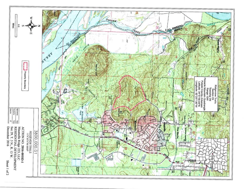
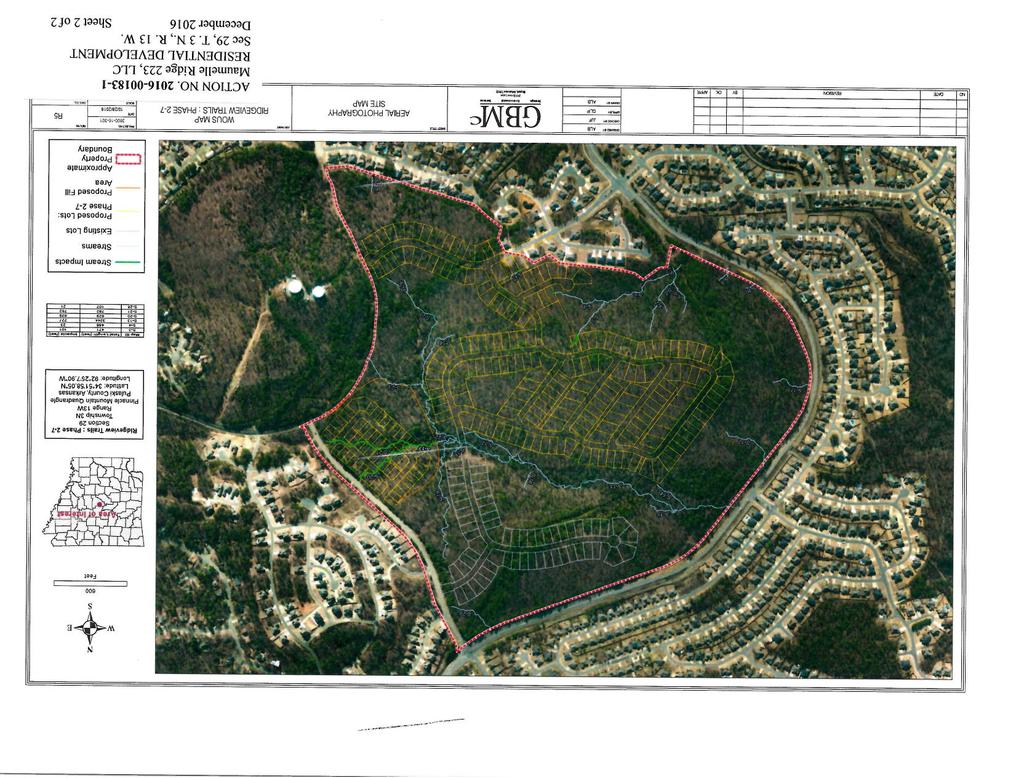
1 US Army Corps of Engineers Little Rock District JOINT PUBLIC NOTICE CORPS OF ENGINEERS STATE OF ARKANSAS Application Number: Date: December 9, 2016 Comments Due: January 3, 2017 TO WHOM IT MAY CONCERN: Comments are invited on the work described below. Please see the Public Involvement section for details on submitting comments. Point of Contact. If additional information is desired, please contact the regulator, Christopher G. Davies, telephone number: (501) , mailing address: Little Rock District Corps of Engineers, Regulatory Division, PO Box 867, Little Rock, Arkansas , address: Project Information. Pursuant to Section 404 of the Clean Water Act (33 U.S. Code 1344), notice is hereby given that Mr. Todd Witham Maumelle Ridge 223, LLC 5 Deauville Circle Little Rock, Arkansas has requested authorization for the placement of dredged and fill material in waters of the United States associated with an 83-acre residential development project. The proposed project is located in unnamed tributaries of Palarm Creek, in section 29, T. 3 N., R. 13 W., Maumelle, Pulaski County, Arkansas. The basic purpose of the project is to construct a residential development. The overall purpose of the project is to develop the site to serve the housing needs for the City of Maumelle and Central Arkansas. The project is not water dependent. The applicant proposes a residential subdivision that includes five phases of development. Fill material will be placed in eight tributaries to facilitate residential lot development. Approximately 227 feet of intermittent stream and 1,556 feet of ephemeral stream will be impacted by the project. The terrain is currently rugged and forested. The adjacent property is primarily residential subdivisions. The tract contains two prominent narrow ridges. In the north, a ridge spur off of Cook Mountain crests at 450 feet National Geodetic Vertical Datum (NGVD), and to the south a somewhat broader parallel ridge peaks at 460 feet NGVD. The terrain is lowest, less than 260 feet NGVD, on the western portion of the tract. Twenty-eight ephemeral streams totaling approximately 11,822 feet in length and one intermittent stream measuring approximately 3,245 feet in length have been identified on the property. The proposed subdivision development was designed to avoid and minimize aquatic impacts as much as practicable. Of the over 15,000 feet of streams identified on the parcel, less than 2,
2 feet would be impacted. The applicant has proposed on-site mitigation that would consist of protection of approximately 2,692 feet of intermittent stream and 690 feet of ephemeral stream, along with enhancement of its riparian corridor. The location and general plan for the proposed work are shown on the enclosed sheets. Water Quality Certification. By copy of this public notice, the applicant is requesting water quality certification from the Arkansas Department of Environmental Quality (ADEQ) in accordance with Section 401(a)(1) of the Clean Water Act. Upon completion of the comment period and a public hearing, if held, a determination relative to water quality certification will be made. Evidence of this water quality certification or waiver of the right to certify must be submitted prior to the issuance of a Corps of Engineers permit. Cultural Resources. A Corps staff archeologist will review topographic maps, the National Register of Historic Places, and other data on reported sites in the area. The District Engineer invites responses to this public notice from Native American Nations or tribal governments; Federal, State, and local agencies; historical and archeological societies; and other parties likely to have knowledge of or concerns with historic properties in the area. Endangered Species. Our preliminary determination is that the proposed activity will not affect listed Endangered Species or their critical habitat. A copy of this notice is being furnished to the U.S. Fish and Wildlife Service and appropriate state agencies and constitutes a request to those agencies for information on whether any listed or proposed-to-be-listed endangered or threatened species may be present in the area which would be affected by the proposed activity. Floodplain. We are providing copies of this notice to appropriate floodplain officials in accordance with 44 Code of Federal Regulations (CFR) Part 60 (Floodplain Management Regulations Criteria for Land Management and Use) and Executive Order on Floodplain Management. Section 404(b)(1) Guidelines. The evaluation of activities to be authorized under this permit, which involves the discharge of dredged or fill material will include application of guidelines promulgated by the Administrator, Environmental Protection Agency, under authority of Section 404(b) of the Clean Water Act. These guidelines are contained in 40 Code of Federal CFR 230. Public Involvement. Any interested party is invited to submit to the above-listed POC written comments or objections relative to the proposed work on or before January 3, Substantive comments, both favorable and unfavorable, will be accepted and made a part of the record and will receive full consideration in determining whether this work would be in the public interest. The decision whether to issue a permit will be based on an evaluation of the probable impact including cumulative impacts of the proposed activity on the public interest. That decision will reflect the national concern for both protection and utilization of important resources. The benefit, which reasonably may be expected to accrue from the proposal, must be balanced against its reasonably foreseeable detriments. All factors which may be relevant to the proposal will be considered including the cumulative effects thereof; among those are conservation, economics, aesthetics, general environmental concerns, wetlands, historic - 2 -
3 properties, fish and wildlife values, flood hazards, floodplain values, land use, navigation, shoreline erosion and accretion, recreation, water supply and conservation, water quality, energy needs, safety, food and fiber production, mineral needs, considerations of property ownership and, in general, the needs and welfare of the people. The Corps of Engineers is soliciting comments from the public; Federal, state, and local agencies and officials; Indian Tribes; and other interested parties in order to consider and evaluate the impacts of this proposed activity. Any comments received will be considered by the Corps of Engineers to determine whether to issue, modify, condition or deny a permit for this proposal. To make this decision, comments are used to assess impacts on endangered species, historic properties, water quality, general environmental effects, and the other public interest factors listed above. Comments are used in the preparation of an Environmental Assessment and/or an Environmental Impact Statement pursuant to the National Environmental Policy Act. Comments are also used to determine the need for a public hearing and to determine the overall public interest of the proposed activity. Any person may request in writing within the comment period specified in this notice that a public hearing be held to consider this application. Requests for public hearings shall state, with particularity, the reasons for holding a public hearing. The District Engineer will determine if the issues raised are substantial and whether a hearing is needed for making a decision. NOTE: The mailing list for this Public Notice is arranged by state and county(s) where the project is located, and includes any addressees who have asked to receive copies of all public notices. Please discard notices that are not of interest to you. If you have no need for any of these notices, please advise us so that your name can be removed from the mailing list. Enclosures Approximate Coordinates of Project Center Latitude: Longitude: UTM Zone: 15N North: East:
4
5
Public Notice. Notice No Closing Date: August 16, 2018
 Public Notice U.S. Army Corps of Engineers Pittsburgh District In Reply Refer to Notice No. below US Army Corps of Engineers, Pittsburgh District 1000 Liberty Avenue Pittsburgh, PA 15222-4186 Application
NOTICE DATE: August 19, Joint Public Notice. U.S. Army Corps of Engineers and State of Arkansas
 US Army Corps of Engineers Memphis District Public Notice FILE NUMBER: MVM-2013-182 (RCW) NOTICE DATE: August 19, 2013 Attn: Postmaster, Please Post Until EXPIRATION DATE: September 18, 2013 Joint Public
JOINT PUBLIC NOTICE PUBLIC NOTICE
 Albuquerque District JOINT PUBLIC NOTICE PUBLIC NOTICE Application Number: SPA-2012-00299-ABQ Date: October 20, 2014 Comments Due: November 20, 2014 SUBJECT: The U.S. Army Corps of Engineers, Albuquerque
Public Notice U.S. ARMY CORPS OF ENGINEERS, GALVESTON DISTRICT AND TEXAS COMMISSION ON ENVIRONMENTAL QUALITY
 Public Notice U.S. Army Corps Permit Application No: SWG-2016-00384 Of Engineers Date Issued: 27 December 2018 Galveston District Comments Due: 29 January 2019 U.S. ARMY CORPS OF ENGINEERS, GALVESTON DISTRICT
NOTICE DATE: August 8, Public Notice U.S. Army Corps of Engineers
 m US Army Corps of Engineers Memphis District FILE NUMBER: MVM 1991-432 (JME) Public Notice NOTICE DATE: August 8, 2017 Attn: Postmaste.r, EXPIRATION DATE: Please Post Unlllc::::;> August 22, 2017 Public
Joint Public Notice. US Army Corps of Engineers Louisville District
 Joint Public Notice US Army Corps of Engineers Louisville District Public Notice No. LRL-2016-00110-gjd Open Date: 13 Feb 2017 Close Date: 15 Mar 2017 Please address all comments and inquiries to: U.S.
PUBLIC NOTICE. Attn: David Syster 5315 South College Road., Suite E Wilmington, North Carolina 28412
 US Army Corps Of Engineers Wilmington District PUBLIC NOTICE Issue Date: April 23, 2013 Comment Deadline: May 23, 2013 Corps Action ID #: SAW-2003-00214 The Wilmington District, Corps of Engineers (Corps)
SPECIAL PUBLIC NOTICE
 SPECIAL PUBLIC NOTICE U.S. ARMY CORPS OF ENGINEERS BUILDING STRONG LOS ANGELES DISTRICT APPLICATION FOR PERMIT Coachella Valley In-Lieu Fee Program Public Notice/Application No.: SPL-2013-00324-TOB Project:
PUBLIC NOTICE. _x_ Section 404 of the Clean Water Act Section 1 03 of the Marine Protection, Research and Sanctuaries Act.
 US Army Corps of Engineers New England District Maine Project Office 675 Western Avenue, #3 Manchester, Mai11e 04351 PUBLC NOTCE Comment Period Begins: April 22,2014 Comment Period Ends: May 22,2014 File
PUBLIC NOTICE. Attn: Corey Lamarche 10 Presidential Way Woburn, Massachusetts 01801
 US Army Corps Of Engineers Wilmington District PUBLIC NOTICE Issue Date: April 9, 2014 Comment Deadline: May 8, 2014 Corps Action ID #: SAW-2010-01235 The Wilmington District, Corps of Engineers (Corps)
Public Notice. Applicant: Avere Real Estate Project No.: SWF Date: May 30, Phone Number:
 Public Notice Applicant: Avere Real Estate Project No.: SWF-2017-00150 Date: May 30, 2017 Purpose The purpose of this public notice is to inform you of a proposal for work in which you might be interested.
Public Notice U.S. Army Corps In Reply to Application Number CENAB-OP-RMS (WANAMAKER, GEOFFERY & SUSAN) Baltimore District
 Baltimore District") Public Notice U.S. Army Corps In Reply to Application Number of Engineers CENAB-OP-RMS (WANAMAKER, GEOFFERY & SUSAN) Baltimore District 2014-60188 PN 14-33 Comment Period: June 6, 2014 to July 7, 2014
Public Notice U.S. Army Corps In Reply to Application Number of Engineers CENAB-OP-RMS (WANAMAKER, GEOFFERY & SUSAN) Baltimore District 2014-60188 PN 14-33 Comment Period: June 6, 2014 to July 7, 2014
Chapter 5. Floodplain Management. 5.0 Introduction. 5.1 Floodplain Management and Regulation
 5.0 Introduction This chapter summarizes the Town s rules and regulations regarding floodplain management and development. The requirements presented in this chapter should be used by the design engineer
Department of Legislative Services Maryland General Assembly 2010 Session
 Department of Legislative Services Maryland General Assembly 2010 Session SB 1128 FISCAL AND POLICY NOTE Revised Senate Bill 1128 (Senator Colburn) Education, Health, and Environmental Affairs Environmental
DEPARTMENT OF THE ARMY OFFICE OF THE CHIEF OF ENGINEERS WASHINGTON, D.C
 DEPARTMENT OF THE ARMY OFFICE OF THE CHIEF OF ENGINEERS WASHINGTON, D.C. 20314-1000 REPLY TO ATTENTION OF: CECW-PM (10-1-7a) THE SECRETARY OF THE ARMY 1. I submit for transmission to Congress my report
***** Subchapter A. GENERAL PROVISIONS ***** PERMIT APPLICATIONS
 105.11. Permit requirements. 105.12. Waiver of permit requirements. Title 25 Environmental Protection Part I. Department of Environmental Protection Subpart C. Protection of Natural Resources Article I.
Honolulu District U.S. Army Corps of Engineers
 Honolulu District U.S. Army Corps of Engineers Nationwide Permit Pre-Construction Notification (PCN) This PCN template integrates requirements of the U.S. Army Corps of Engineers (Corps) Nationwide Permit
Record of Decision Mt. Hood National Forest Geothermal Leases August Record of Decision. Mt. Hood National Forest Geothermal Leases
 Summary Record of Decision Mt. Hood National Forest Geothermal Leases USDA Forest Service Mt. Hood National Forest Hood River and Barlow Ranger Districts Hood River County, Oregon It is my recommendation
THIS DECLARATION OF RESTRICTIVE COVENANTS is made this day of, 20, by ("Covenantor"). RECITALS
. RECITALS") Model for Use with Permits Without Mitigation Plans STATE OF COUNTY OF DECLARATION OF RESTRICTIVE COVENANTS THIS DECLARATION OF RESTRICTIVE COVENANTS is made this day of, 20, by ("Covenantor"). RECITALS
Model for Use with Permits Without Mitigation Plans STATE OF COUNTY OF DECLARATION OF RESTRICTIVE COVENANTS THIS DECLARATION OF RESTRICTIVE COVENANTS is made this day of, 20, by ("Covenantor"). RECITALS
Chapter 5. Floodplain Management. 5.0 Introduction. 5.1 Douglas County Comprehensive Master Plan. 5.2 Floodplain Management and Regulation
 5.0 Introduction This chapter summarizes the County s rules and regulations regarding floodplain management and development. The requirements presented in this chapter should be used by the design engineer
FINDING OF NO SIGNIFICANT IMPACT TENNESSEE VALLEY AUTHORITY DISPOSAL FEE OWNERSHIP OF YELLOW CREEK INDUSTRIAL PARK PROPERTIES
 FINDING OF NO SIGNIFICANT IMPACT TENNESSEE VALLEY AUTHORITY DISPOSAL FEE OWNERSHIP OF YELLOW CREEK INDUSTRIAL PARK PROPERTIES In 1971, the Tennessee Valley Authority (TVA) partnered with the Mississippi
Part 72. Sec. 1. This ordinance shall be known and may be cited as the Clyde Township Wetlands Ordinance.
 Part 72 72.000 WETLANDS ORDINANCE Ord. No. 1 Adopted: June 12, 1991 Amended: April 13, 1994 72.001 SHORT TITLE. 72.002 PURPOSE. 72.003 DEFINITIONS. CLYDE TOWNSHIP ORDAINS: Sec. 1. This ordinance shall
GWINNETT COUNTY CSO CONSERVATION SUBDIVISION OVERLAY DISTRICT REQUIREMENTS
 GWINNETT COUNTY CSO CONSERVATION SUBDIVISION OVERLAY DISTRICT REQUIREMENTS Section 1316. CSO Conservation Subdivision Overlay District. 1. Purposes. The purposes of this overlay district are as follows:
REVISED 15 DAY NOTICE PUBLIC NOTICE
 REVISED 15 DAY NOTICE fp.iip.i lliiliil US Anny Corps of Engineers New England District 696 Virginia Road Concord, MA 01742-2751 PUBLIC NOTICE Comment Period Begins: February 5, 2013 Comment Period Ends:
February 6, Operations Division Regulatory Branch (North) ID No. LRL dlz
 ID No. LRL dlz") DEPARTMENT OF THE ARMY U.S. ARMY ENGINEER DISTRICT, LOUISVILLE CORPS OF ENGINEERS INDIANAPOLIS REGULATORY OFFICE 8902 OTIS AVENUE, SUITE S106B INDIANAPOLIS, INDIANA 46216 February 6, 2013 Operations Division
DEPARTMENT OF THE ARMY U.S. ARMY ENGINEER DISTRICT, LOUISVILLE CORPS OF ENGINEERS INDIANAPOLIS REGULATORY OFFICE 8902 OTIS AVENUE, SUITE S106B INDIANAPOLIS, INDIANA 46216 February 6, 2013 Operations Division
TURTLE CREEK SUBDIVISION, PHASE THREE
 TURTLE CREEK SUBDIVISION, PHASE THREE Engineering Comments: Must comply with the Mobile County Flood Damage Prevention Ordinance. Development shall be designed to comply with the storm water detention
Central Pennsylvania Conservancy Project Selection Criteria Form
 Central Pennsylvania Conservancy Project Selection Criteria Form The following criteria guide the actions of the Central Pennsylvania Conservancy s Land Protection Committee and Board of Directors in selecting
Project File #: SF Project Name: Jackson Ranch Filing No. 4 Parcel Nos.: , and
 COMMISSIONERS: DARRYL GLENN (PRESIDENT) MARK WALLER (PRESIDENT PRO TEMPORE) STAN VANDERWERF LONGINOS GONZALEZ PEGGY LITTLETON PLANNING AND COMMUNITY DEVELOPMENT DEPARTMENT CRAIG DOSSEY, EXECUTIVE DIRECTOR
CONDITIONAL USE PERMIT Application Packet
 CONDITIONAL USE PERMIT Application Packet Community Development Department 1020 East Pioneer Road, Draper, UT 84020 (801) 576-6539 Fax (801) 576-6526 Dear Applicant, This application packet has been developed
Appendix A Major Federal, State, and Local Permits or Approvals
 TransWest Express EIS Appendix A Major Federal, State, and Local s or Approvals TransWest Express EIS Appendix A A-1 FEDERAL National Environmental Policy Act (NEPA) Compliance Federal action: to grant
COMMUNITY DEVELOPMENT DEPARTMENT 333 Broadalbin Street SW, P.O. Box 490 Albany, OR 97321
 COMMUNITY DEVELOPMENT DEPARTMENT 333 Broadalbin Street SW, P.O. Box 490 Albany, OR 97321 STAFF REPORT Application for Site Plan Review (SP-02-18) Residential Accessory Building Ph: 541-917-7550 Fax: 541-917-7598
ORDINANCE NO WHEREAS, the Town of Jupiter ( Town ) has adopted a Comprehensive Plan
 has adopted a Comprehensive Plan") 0 0 ORDINANCE NO. -0 AN ORDINANCE OF THE TOWN COUNCIL OF THE TOWN OF JUPITER, FLORIDA, AMENDING CHAPTER OF THE TOWN CODE TO AMEND SECTION -, ENTITLED INTENT TO ADD PERMITTING LANDGUAGE; TO AMEND SECTION
0 0 ORDINANCE NO. -0 AN ORDINANCE OF THE TOWN COUNCIL OF THE TOWN OF JUPITER, FLORIDA, AMENDING CHAPTER OF THE TOWN CODE TO AMEND SECTION -, ENTITLED INTENT TO ADD PERMITTING LANDGUAGE; TO AMEND SECTION
ARTICLE XI - CONSERVATION SUBDIVISIONS
 ARTICLE XI - CONSERVATION SUBDIVISIONS Section 1101: Purpose and Intent. This Article is intended to provide for residential subdivisions that are designed based first and foremost on the preservation
Creek Rehabilitation Plan for Apple Valley Questions and Answers from the Pre-Bid Meeting and Site Visit 06/23/2016
 Questions and Answers from the Pre-Bid Meeting and Site Visit 06/23/2016 Q: What are the threatened and endangered species concerns in the area? A: This is potential habitat for Prebles Meadow Jumping
Easement Criteria Evaluation Project: Black Gum Mitigation Bank southern Upshur County, Texas
 Easement Criteria Evaluation Project: Black Gum Mitigation Bank southern Upshur County, Texas Project Address: on the Sabine River south of Hwy 80 in southern Upshur County, Texas (entrance located about
South Mississippi Branch July 10, 2015 Regulatory Division JOINT PUBLIC NOTICE SAM MJF U.S. ARMY CORPS OF ENGINEERS
 DEPARTMENT OF THE ARMY U.S. ARMY ENGNEER DSTRCT, MOBLE DSTRCT P.O. BOX 2288 MOBLE, ALABAMA 36628-0001 South Mississippi Branch July 10, 2015 Regulatory Division JONT PUBLC NOTCE SAM-2015-00140-MJF U.S.
Town of Alexandria. Floodplain Management Ordinance
 1 of 7 8/8/2009 4:56 PM Town of Alexandria Floodplain Management Ordinance SECTION 1 PURPOSE Certain areas of the Town of Alexandria, New Hampshire are subject to periodic flooding, causing serious damages
INFORMATION REQUIRED FOR ALABAMA GENERAL PERMITS - BW&T LAKES
 INFORMATION REQUIRED FOR ALABAMA GENERAL PERMITS - BW&T LAKES THE FOLLOWING COMPLETED DOCUMENTS MUST BE RETURNED BEFORE PERMIT CAN BE ISSUED: 1. DESCRIPTION INFORMATION LIST 2. JOINT APPLICATION FORM 1668-02
For the reasons set forth in the preamble, the Department proposes to amend 25 CFR 151
 For the reasons set forth in the preamble, the Department proposes to amend 25 CFR 151 as follows: 1. Revise Part 151 of Title 25 of the Code of Federal Regulations to read as follows: PART 151 LAND ACQUISITION
Coastal Shore Jurisdiction in British Columbia
 ISSUE SHEET October 2009 Coastal Shore Jurisdiction in British Columbia Ju ris dic tion: the power, right and authority to interpret and apply the law. (Merriam Webster on-line) Who s in charge of coastal
LAND USE APPLICATION
 LAND USE APPLICATION File Name: File No(s).: Receipt No.: Receipt Date: Received By: Amount.: $ Instructions for Applicants Please read and follow all instructions on your application carefully. If you
Floodplain Development Land Use Review
 PUBLIC WORKS - COMMUNITY DEVELOPMENT 333 Broadalbin Street SW, PO Box 490, Albany, Oregon 97321-0144 BUILDING 541-917-7553 PLANNING 541-917-7550 Floodplain Development Land Use Review Application Information
How Mitigation Banks and ILF Programs Can Help Conservation
 How Mitigation Banks and ILF Programs Can Help Conservation Devin Schenk, Mitigation Program Manager Anthony Sasson The Nature Conservancy Mission: To conserve the lands and waters for which all life depends
File Name: Conditional Use Application_2017
 Office Use Only Recv d: By: App #: #: Meeting Date: Conditional Use Application 2017 FEE: $2,500.00. The fee is payable upon application submittal. *Any additional meeting with mailed & published notice
Land Use Application
 Land Use Application Check all permits you are applying for in the boxes provided. Submit this application form, the applicable materials listed in the corresponding permit application packet(s) and application
APPENDIX D - REAL ESTATE
 APPENDIX D - REAL ESTATE 1. Purpose Real Estate Plan For Feasibility Study For Lake Lou Yaeger Section 206 Aquatic Ecosystem Restoration Continuing Authorities Project Feasibility Study This report is
MS MINOR SUBDIVISION TREVITHICK
 MS-02-015 341.12 MINOR SUBDIVISION TREVITHICK A request by Danny Trevithick for a one-lot Minor Subdivision on five acres. The property is zoned A-35 (Agricultural) District and is located ¼ mile south
Section Floodplain Development Ordinance This ordinance, adopted pursuant to the authority of RSA 674:16, shall be known as the Town of Newport
 Section 212 - Floodplain Development Ordinance This ordinance, adopted pursuant to the authority of RSA 674:16, shall be known as the Town of Newport Floodplain Development Ordinance. The regulations and
Jurisdictional Determination Request
 This form is intended for use by anyone requesting a jurisdictional determination (JD) from the U.S. Army Corps of Engineers, Wilmington District (Corps). Please include all supporting information, as
SEQRA (For Land Surveyors) Purpose of this Presentation
 Purpose of this Presentation") SEQRA (For Land Surveyors) Purpose of this Presentation Understand the basics and legal requirements of SEQRA Recognize the role that Land Surveyors play in the SEQRA Identify the problems posed by SEQRA
SEQRA (For Land Surveyors) Purpose of this Presentation Understand the basics and legal requirements of SEQRA Recognize the role that Land Surveyors play in the SEQRA Identify the problems posed by SEQRA
Chapter 100 Planned Unit Development in Corvallis Urban Fringe
 100.100 Scope and Purpose. Chapter 100 Planned Unit Development in Corvallis Urban Fringe (1) All applications for land divisions in the Urban Residential (UR) and Flood Plain Agriculture (FPA) zones within
Napa County Planning Commission Board Agenda Letter
 Agenda Date: 9/20/2017 Agenda Placement: 8C Napa County Planning Commission Board Agenda Letter TO: FROM: Napa County Planning Commission Charlene Gallina for David Morrison - Director Planning, Building
Federal Emergency Management Agency
 Page 1 of 3 Date: July 21, 2016 Case No.: 16-05-5203A LOMA COMMUNITY AND MAP PANEL INFORMATION COMMUNITY KEWAUNEE COUNTY, WISCONSIN (Unincorporated Areas) Federal Emergency Management Agency Washington,
NOTICE OF LAND USE DECISION BY THE COOS COUNTY PLANNING DIRECTOR
 NOTICE OF LAND USE DECISION BY THE COOS COUNTY PLANNING DIRECTOR Coos County Planning 225 N. Adams St. Coquille, OR 97423 http://www.co.coos.or.us/ Phone: 541-396-7770 Fax: 541-396-1022 This notice is
Forest Service Role CHAPTER 2
 CHAPTER 2 Forest Service Role Implementation of the Management Plan charters a federal presence with an expanded focus beyond traditional Forest Service roles. In addition to administration of the National
BY BOARD OF COUNTY COMMISSIONERS AN ACT TO BE ENTITLED
 BY BOARD OF COUNTY COMMISSIONERS ORDINANCE NO. AN ACT TO BE ENTITLED AN ORDINANCE AMENDING THE PASCO COUNTY LAND DEVELOPMENT CODE, ARTICLE 700, BY REPEALING EXISTING SECTION 702, ENVIRONMENTALLY SENSITIVE
Rarity Pointe Commercial Recreation and Residential Development on Tellico Reservoir, Loudon and Monroe Counties, TN
 ======================================================================= Federal Register: September 10, 2003 (Volume 68, Number 175) =======================================================================
DECLARATION OF RESTRICTIVE COVENANTS. THIS DECLARATION OF RESTRICTIVE COVENANTS made this day of, 200_, by ( Declarant ). RECITALS
. RECITALS") DECLARATION OF RESTRICTIVE COVENANTS THIS DECLARATION OF RESTRICTIVE COVENANTS made this day of, 200_, by ( Declarant ). RECITALS WHEREAS, Declarant is the owner of the surface of certain real property
DECLARATION OF RESTRICTIVE COVENANTS THIS DECLARATION OF RESTRICTIVE COVENANTS made this day of, 200_, by ( Declarant ). RECITALS WHEREAS, Declarant is the owner of the surface of certain real property
Record of Decision and Statement of Findings for Department of the Army (DA) Permit Application SAJ Attachment C
 Permit Application SAJ Attachment C") Record of Decision and Statement of Findings for Department of the Army (DA) Permit Application SAJ-1993-01395 Attachment C Attachment C Figure 1 - No Action Uplands Only Figure 2 - Upland mining with
Record of Decision and Statement of Findings for Department of the Army (DA) Permit Application SAJ-1993-01395 Attachment C Attachment C Figure 1 - No Action Uplands Only Figure 2 - Upland mining with
PROJECT SCORING GUIDANCE. Introduction: National Proiect Selection:
 FOREST LEGACY PROGRAM PROJECT SCORING GUIDANCE Introduction: This document provides guidance to the National Review Panel on how to score individual Forest Legacy Program (FLP) projects, including additional
Federal Mandates and Willing Sellers: Real Estate Acquisition for the Missouri River Recovery Program
 Federal Mandates and Willing Sellers: Real Estate Acquisition for the Missouri River Recovery Program Brad Thompson, Chief, Civil Works Branch U.S. Corps of Engineers, Omaha District US Army Corps of Engineers
IMPLEMENTING AGREEMENT. for the EAST CONTRA COSTA COUNTY HABITAT CONSERVATION PLAN/ NATURAL COMMUNITY CONSERVATION PLAN.
 IMPLEMENTING AGREEMENT for the EAST CONTRA COSTA COUNTY HABITAT CONSERVATION PLAN/ NATURAL COMMUNITY CONSERVATION PLAN by and between EAST CONTRA COSTA COUNTY HABITAT CONSERVANCY, COUNTY OF CONTRA COSTA,
A. Maintenance. All legally established, nonconforming structures can be maintained (e.g., painting and repairs);
;") Chapter 24.50 NONCONFORMING USES, STRUCTURES AND LOTS Sections: 24.50.010 Nonconforming uses, structures, and lots Purpose. 24.50.020 Nonconforming uses, structures, and lots Alteration or expansion of
Chapter 24.50 NONCONFORMING USES, STRUCTURES AND LOTS Sections: 24.50.010 Nonconforming uses, structures, and lots Purpose. 24.50.020 Nonconforming uses, structures, and lots Alteration or expansion of
CITY OF FORT COLLINS NATURAL AREAS AND CONSERVED LANDS EASEMENT POLICY
 CITY OF FORT COLLINS NATURAL AREAS AND CONSERVED LANDS EASEMENT POLICY Adopted January 3, 2012 PURPOSE: The purpose of the policy statement is to clarify the policies and procedures of the City of Fort
Savannah District. Regulatory Program. reg199.ppt 1
 Regulatory Program reg199.ppt 1 U.S. U.S. ARMY ARMY CORPS CORPS OF OF ENGINEERS ENGINEERS SAVANNAH SAVANNAH DISTRICT DISTRICT IN-LIEU FEE MITIGATION PROGRAM reg199.ppt 2 2008 2008 MITIGATION MITIGATION
Mitigation Banking Instrument Outline For Proposed Mitigation Banks Within the State of Missouri (February 2015)
") Mitigation Banking Instrument Outline For Proposed Mitigation Banks Within the State of Missouri (February 2015) The U.S. Army Corps of Engineers (Corps) and U.S. Environmental Protection Agency joint
Mitigation Banking Instrument Outline For Proposed Mitigation Banks Within the State of Missouri (February 2015) The U.S. Army Corps of Engineers (Corps) and U.S. Environmental Protection Agency joint
Chapter HABITAT CONSERVATION PLAN / NATURAL COMMUNITY CONSERVATION PLAN IMPLEMENTATION ORDINANCE
 Chapter 15.108 HABITAT CONSERVATION PLAN / NATURAL COMMUNITY CONSERVATION PLAN IMPLEMENTATION ORDINANCE Sections: 15.108.010 Purpose. 15.108.020 Definitions. 15.108.030 Applicability 15.108.040 Responsibility
** If your lot does not meet the requirements above, please read Sec below
 Sec. 13-1-60 Zoning District Dimensional Requirements. For the Zoning Dept To Issue a Land Use Permit The Following Dimensions are Required. Minimum Side and Rear Yards s Lakes Classification Minimum Class
Grand Mesa, Uncompahgre and Gunnison National Forests Region 2, USDA Forest Service
 Decision Memo Taylor River Land Exchange Under the General Exchange Act of March 20, 1922 as Amended, The Federal Land Policy and Management Act of 1976 as Amended and the Federal Land Exchange Facilitation
Town of Lisbon, Maine SUBDIVISION REVIEW APPLICATION
 Date Received: Fee Paid (amount): Applicant: Town of Lisbon, Maine SUBDIVISION REVIEW APPLICATION Subdivision Name/Title: This application must be received at the Town Office by close of business on the
Our Staff Member are committed to helping you during this process.
 Sandbridge General Permit Sand Management Sandbridge General Permit Application Instructions The Virginia Beach Wetlands Board adopted a General Permit for Sand Management & Sand Placement for properties
Guide to Combined Preliminary and Final Plats
 Guide to Combined Preliminary and Final Plats Introduction The Douglas County is committed to providing open, transparent application processes to the public. This Guide is provided to assist anyone interested
DRAFT FOR PUBLIC HEARING (rev. March, 2016)
") Chapter 200. ZONING Article VI. Conservation/Cluster Subdivisions 200-45. Intent and Purpose These provisions are intended to: A. Guide the future growth and development of the community consistent with
Chapter 200. ZONING Article VI. Conservation/Cluster Subdivisions 200-45. Intent and Purpose These provisions are intended to: A. Guide the future growth and development of the community consistent with
PACIFIC REGION LAND ACQUISITION REQUIREMENTS
 PACIFIC REGION LAND ACQUISITION REQUIREMENTS The following is an outline of the filing requirements for tribal land acquisition requests and timeframes involved for various steps of the process: 1) All
AMENDED DEED OF CONSERVATION EASEMENT
 Prepared by: Wayne E. Flowers Lewis, Longman & Walker, P.A. 245 Riverside Ave. Suite 150 Jacksonville, FL 32202 Return recorded original to: Mitigation Marketing 1091 W. Morse Blvd. Suite 101 Winter Park,
City of North Miami Beach, Florida Planning and Zoning Department
 City of North Miami Beach, Florida Planning and Zoning Department Planning and Zoning Board Staff Report TO: FROM: Planning and Zoning Board Carlos Rivero, City Planner DATE: June 8, 2015 ITEM: 15-007(B)
DECLARATION OF RESTRICTIVE COVENANTS
 DECLARATION OF RESTRICTIVE COVENANTS The Declarant,, is the fee simple owner of the certain real property located in County, Kansas, as described on Exhibit A, which is attached hereto and incorporated
Chapter Planned Residential Development Overlay
 Chapter 19.29 Planned Residential Development Overlay Sections 010 Purpose 020 Scope 030 Definitions 030 Minimum Size 040 Allowable Uses 050 Minimum Development Standards 060 Density Bonus 070 Open Space
COCHRAN FAMILY RIVERSIDE ESTATE SUBDIVISION
 # 19 SUB2012-00111 COCHRAN FAMILY RIVERSIDE ESTATE SUBDIVISION Engineering Comments: The following comments should be addressed prior to review, acceptance and signature by the City Engineer: 1. Label/show
WASCO COUNTY PRELIMINARY SUBDIVISION APPLICATION
 WASCO COUNTY PRELIMINARY SUBDIVISION APPLICATION DETAILED SPECIFIC WRITTEN REQUEST File Number: SDV- Number of Proposed Lots & their Dimensions: PRELIMINARY SUBDIVISION PLAN REQUIREMENTS The approval of
New Cingular Wireless Telecommunication Tower at County Road 48, Milner Conditional Use Permit
 New Cingular Wireless Telecommunication Tower at 39415 County Road 48, Milner ACTIVITY #: Conditional Use Permit PP2012-023 HEARING DATES: Planning Commission (PC): August 16, 2012 at 6:00pm PETITIONER:
ALREADY SUBMITTED FOR HIGHLANDS COUNCIL PRE
 Highlands Preservation Area Approval Application Checklist Items Block 15901 Lot 1, West Milford See Highlands Council Review at: http://www.highlands.state.nj.us/njhighlands/projectreview/ **For advisory
BRISTOL CONSERVATION COMMISSION INLAND WETLANDS AGENCY FORM IW-1 (Application for a Wetlands Permit)
") APPLICATION NO. BRISTOL CONSERVATION COMMISSION INLAND WETLANDS AGENCY FORM IW-1 (Application for a Wetlands Permit) DATE FILED: APPROVED: DENIED: 1. APPLICANT: Name: Signature: Address: City: State: Zip
APPLICATION NO. BRISTOL CONSERVATION COMMISSION INLAND WETLANDS AGENCY FORM IW-1 (Application for a Wetlands Permit) DATE FILED: APPROVED: DENIED: 1. APPLICANT: Name: Signature: Address: City: State: Zip
Chesapeake Bay Preservation Area (CBPA) Map Update. Presentation to the County Board July 15, 2017
 Map Update. Presentation to the County Board July 15, 2017") Chesapeake Bay Preservation Area (CBPA) Map Update Presentation to the County Board July 15, 2017 Chesapeake Bay Program Comprehensive Plan Chesapeake Bay Preservation Ordinance (1992) (Chapter 61, Arlington
Chesapeake Bay Preservation Area (CBPA) Map Update Presentation to the County Board July 15, 2017 Chesapeake Bay Program Comprehensive Plan Chesapeake Bay Preservation Ordinance (1992) (Chapter 61, Arlington
APPENDIX D REAL ESTATE PLAN
 APPENDIX D REAL ESTATE PLAN APPENDIX D REAL ESTATE PLAN TABLE OF CONTENTS 1. STATEMENT OF PURPOSE 2. REFERENCES 3. AUTHORIZATION 4. BACKGROUND 5. LOCATION 6. REAL ESTATE REQUIREMENTS 7. OWNERSHIP OF REAL
Staff Report Amended Amended to correct file number. File Number: CD Reviewed by: Alex Murphy, GIS Planner I
 Coos County Planning Department Coos County Courthouse Annex, Coquille, Oregon 97423 Mailing Address: 250 N. Baxter, Coos County Courthouse, Coquille, Oregon 97423 Physical Address: 225 N. Adams, Coquille,
NOTICE OF INTENT FOR DISCHARGES OF STORM WATER ASSOCIATED WITH MEDIUM OR LARGE CONSTRUCTION ACTIVITY AUTHORIZED UNDER NPDES GENERAL PERMIT ARR150000
 NOTICE OF INTENT FOR DISCHARGES OF STORM WATER ASSOCIATED WITH MEDIUM OR LARGE CONSTRUCTION ACTIVITY AUTHORIZED UNDER NPDES GENERAL PERMIT ARR150000 The enclosed form may be used to obtain coverage under
Initial Subdivision Applications Shall Include the Following:
 Initial Subdivision Applications Shall Include the Following: 1) Subdivision Application Form: completely filled out (12 copies) 2) Plat: The Plat must adhere to the requirements set forth in the Town
ZONING PERMIT APPLICATION
 ZONING PERMIT APPLICATION OFFICE USE ONLY Date Received: FILE NO. 120 DAY EXPIRATION Purpose: Some types of land use activities listed in the Lake County Zoning Ordinance are allowed to occur with a minimal
3.23 LANDS AND SPECIAL USES
 3.23 LANDS AND SPECIAL USES Introduction This section addresses those aspects of SJPLC management relating to public land ownership and use. Special Use Permits, rights-of-way (ROW) grants, easements,
SUMMARY: The Tennessee Valley Authority (TVA) has decided to adopt proposed reservoir
 has decided to adopt proposed reservoir") This document is scheduled to be published in the Federal Register on 09/12/2017 and available online at https://federalregister.gov/d/2017-19310, and on FDsys.gov 8120-08-P TENNESSEE VALLEY AUTHORITY
This document is scheduled to be published in the Federal Register on 09/12/2017 and available online at https://federalregister.gov/d/2017-19310, and on FDsys.gov 8120-08-P TENNESSEE VALLEY AUTHORITY
Citizen and Developer s Guide to the Permitting and Approval Process for Land Development in Benton Township, Columbia County, Pennsylvania
 Citizen and Developer s Guide to the Permitting and Approval Process for Land Development in Benton Township, Columbia County, Pennsylvania Contact Information Benton Township 236 Shickshinny Road Benton,
Colorado Parks and Wildlife. Acquisition Selection for the Colorado Wildlife Habitat Protection Program
 Colorado Parks and Wildlife Acquisition Selection for the Colorado Wildlife Habitat Protection Program State Wildlife Action Plan and CPW s Strategic Plan: *Conserve wildlife and habitat to ensure healthy
MINOR BOUNDARY LINE ADJUSTMENT PROCESS GUIDE
 MINOR BOUNDARY LINE ADJUSTMENT PROCESS GUIDE Clear Creek County Planning Department P.O. Box 2000 Georgetown, Colorado 80444 (303) 679-2436 phone (303) 569-1103 fax 1 PURPOSE To establish criteria and
Conditional Use Permit in the Floodway Overlay District Application Packet
 Conditional Use Permit in the Floodway Overlay District Application Packet 1. Application Packet. Be sure to complete and submit all the required materials that are a part of this Application Packet. Failure
COASTAL CONSERVANCY. Staff Recommendation January 18, Carmel River Parkway Acquisitions. File No Project Manager: Trish Chapman
 COASTAL CONSERVANCY Staff Recommendation January 18, 2006 Carmel River Parkway Acquisitions File No. 06-104 Project Manager: Trish Chapman RECOMMENDED ACTION: Authorization to disburse up to $3,500,000
MAJOR BOUNDARY LINE ADJUSTMENT PROCESS GUIDE
 MAJOR BOUNDARY LINE ADJUSTMENT PROCESS GUIDE Clear Creek County Planning Department P.O. Box 2000 Georgetown, Colorado 80444 (303) 679-2436 - phone (303) 569-1103 - fax PURPOSE To establish criteria and
Finnerty, Shawn & Lori Water Front Setback
 BONNER COUNTY PLANNING DEPARTMENT PLANNING AND ZONING COMMISSION STAFF REPORT FOR NOVEMBER 2, 2017 Project Name: Finnerty, Shawn & Lori Water Front Setback File Number, Type: FILE #V492-17, Variance Request
TOWN OF WEBSTER Board of Appeals Application Form Area Variance
 Revised 1/2013 TOWN OF WEBSTER Board of Appeals Application Form Area Variance 1. Application Form: Applicant shall complete and submit to the Engineering Department one completed application form which
FRESHWATER WETLANDS PROTECTION IN NEW JERSEY Tools for Municipal Action
 FRESHWATER WETLANDS PROTECTION IN NEW JERSEY Tools for Municipal Action The Freshwater Wetlands Protection Act INTENT OF FRESHWATER WETLANDS LAW The New Jersey legislature passed the Freshwater Wetlands