COUNTY OF SACRAMENTO CALIFORNIA
|
|
|
- Bertha McCarthy
- 5 years ago
- Views:
Transcription
1 COUNTY OF SACRAMENTO CALIFORNIA Control No.: PLNP Type: PMR TO: FROM: SUBJECT: SUBDIVISION REVIEW COMMITTEE PLANNING AND COMMUNITY DEVELOPMENT DEPARTMENT CHRIS BOTTIMORE TENTATIVE PARCEL MAP CONTACT: David Gieselman, Planner II, ; PROJECT DESCRIPTION ASSESSOR S PARCEL NOS.: , 004 LOCATION: The property is located on the west side of Twin Cities Road, approximately 3000 feet east of Alta Mesa Road, in the Southeast community. (Supervisor District 5: Don Nottoli) APPLICANT/ENGINEER: Dick Varney Varney Land Surveys th Avenue Sacramento, CA OWNER: Christopher Bottimore 3231 Lerwick Road Sacramento, CA REQUEST: 1. A Tentative Parcel Map to divide approximately gross acres into 3 parcels in the AG-20/AG-20(F) zones. ENVIRONMENTAL DOCUMENT: NEGATIVE DECLARATION
2 Overview: The proposed project consists of a Tentative Parcel Map to divide approximately 88.5 gross acres into three (3) lots in the AG-20/AG-20(F) zones, located on the west side of Twin Cities Road approximately 3,000 feet east of Alta Mesa Road, in the Southeast Community area. Summary of Significant Issues: Several vernal pools, seasonal wetlands and oak trees exist on the site. The proposed property boundaries, potential building sites and access road have all been configured so as to avoid any impacts to these environmentally sensitive areas. CPAC Recommendation: The Southeast Community Planning Advisory Council (CPAC) met on September 7, 2007 and recommended APPROVAL (5 ayes, 0 noes, 0 abstentions, 0 absences) of the proposed project. The Southeast CPAC provided no additional comments beyond the recommended approval of the project. Recommendations: Staff is recommending APPROVAL of the proposed project, with conditions. I. Location Map 3 II. Project Analysis 4 III. Staff Recommendations 7 IV. Attachments 13 V. Exhibits 14 VI. CPAC Referral 14 srplnp

3 I. LOCATION MAP srplnp
4 II. PROJECT ANALYSIS A. Adjacent Land Uses and Zoning: Existing Land Use Zoning and Community Plan Designations Subject Property Agriculture AG-20/AG-20(F) North Agriculture AG-80/AG-80(F) South Agriculture AG-20/AG-20(F) East Single-family Residential, Southern Pacific Railroad AG-20/AG-20(F) West Agriculture AG-80/AG-80(F) B. History/Background: County records indicate that on June 16, 1966, the area in which the subject property lies was originally zoned AG-20 (Exclusive Agricultural). On July 19, 1979, the Board of Supervisors adopted the Southeast Area Rezone which added a Flood Combining zone onto portions of the property, resulting in the current AG-20/AG-20(F) (Agricultural Holding Zone/Flood Combined) zoning designation. (ZMA 3997, SZC 79-34) C. Project Description: The applicant requests approval of a Tentative Parcel Map to split approximately 88.5 gross acres into three (3) lots in the AG-20/AG-20(F) zones. The subject property is currently configured as two lots one, approximately 79.5 acres, is located to the northwest; and another smaller lot of approximately 9 acres is located to the southeast adjacent to the Southern Pacific Railroad. The proposed map would effectively move the existing property boundary further north and establish a second property line as well, resulting in three total lots. The two northernmost parcels will be approximately 20 gross acres and the third, larger parcel will be approximately 48.5 gross acres. Earlier versions of the map showed a 4-lot split; however, the existence of a seasonal wetland area in the southern area of the property posed constraints on the possible lot configurations. Consequently, the applicant later submitted a revised map proposing a 3-lot configuration in which the seasonal wetland area was clearly avoided. The subject property also has 18 existing vernal pools scattered throughout the site. All locations on the property identified as potential home building sites are outside the required 250-foot buffer area of the vernal pools. D. Consistency with General Plan and/or Community Plan: 1. General Plan: The subject site lies within an area designated General Agriculture (20 ac) on the General Plan Land Use Diagram. The proposed parcels are all at least 20 gross acres in size, which is consistent with the General Agriculture (20 ac) General Plan designation. srplnp
5 2. Community Plan: No community plan has been adopted for the Southeast Community area. E. Neighborhood Compatibility: The lot sizes proposed in the Tentative Parcel Map are 20 acres and 48.5 acres in size. Many existing lots in the vicinity are similar in size to the proposed lots, including three 20-acre lots and one 30-acre lot to the east, a 17-acre lot adjacent to the south, a 58-acre lot further to the south and a 31-acre lot to the southwest. Other lots in the area vary wildly in size, ranging from 2.5 acres to 513 acres. In 1982, a Tentative Parcel Map was requested for the property located directly adjacent to the east (Planning Control No. 82-PM-0030). That project proposed the split of a 60-acre lot into one 40-acre lot and one 20-acre lot and was approved by the Subdivision Review Committee on July 27, Land uses in the vicinity include single-family residential, agricultural, and vacant lots. The proposed parcels will have mainly single-family residential uses, with one possible building site indicated on each of the proposed lots. Considering that the current request is very similar to a previously-approved map, that the proposed lot sizes are very similar to those in the project vicinity, and that the land uses proposed in the current request are the same as those in the surrounding area, staff has determined that the requested Tentative Parcel Map is consistent with the predominant pattern of development in the area. F. Traffic, Access and Circulation Issues: A single 20-foot wide graded private access road along the eastern property boundary will connect the proposed lots to Laguna Road to the north. The Sacramento County Department of Transportation (SacDOT) has reviewed the project and has no comments at this time. The California Department of Transportation (CalTrans) has reviewed the project and has no comments as long as the access for all proposed parcels is taken from Laguna Road and no access is taken from Twin Cities Road; any access to the property from Twin Cities Road would require a CalTrans Encroachment Permit due to the existing Southern Pacific Railroad which runs between the property and Twin Cities Road. The Sacramento County Land Division and Site Improvement Review (LDSIR) has reviewed the project and provided conditions of approval relating to construction and maintenance of the private access road, and requiring an Irrevocable Offer of Dedication for Laguna Road. LDSIR conditions have been entered into Section IV of this report. No issues related to traffic, access or circulation have been identified as of this writing. G. Air Quality: No issues identified at the time of this writing. H. Drainage and Grading Issues: The subject site is located in FEMA Flood Zone A, which is described as an area with a one percent (1%) annual chance of flooding and a twenty-six percent (26%) chance of flooding over the life of a 30-year mortgage. The watershed for the area is Laguna Creek (south of Cosumnes). The Sacramento srplnp
6 County Department of Water Resources (DWR) has reviewed the application and provided conditions of approval relating to compliance with the Sacramento County Floodplain Ordinance, the Sacramento County Water Agency Code and the Sacramento Count Improvement Standards. DWR conditions have been entered into Section IV of this report. No significant issues related to drainage or grading have been identified as of this writing. I. Public Sewer and Water Service Issues: Both the Sacramento Area Sewer District (SASD) and the Sacramento Regional County Sanitation District (SRCSD) have reviewed the project application. The subject property is outside SASD and SRCSD boundaries, as well as the Urban Service Boundary, and no sewer service to the property is available. The areas of the property marked as possible building sites have soils identified as Redding gravelly loam and San Joaquin silt loam. These soils are considered severe for septic tank absorption fields, severe defined as soil properties or site features so unfavorable or so difficult to overcome that special design, significant increases in construction costs, and possibly increased maintenance will be required. A condition requiring Environmental Management Department (EMD) approval for any on-site waste disposal facilities has been added to Section IV of this report. Regarding water service, all Bureau of Reclamation contracts for public water in the site area were ended in 1989, so this portion of the county relies on groundwater for water supply. (The closest available connection to public water is in the City of Galt, a distance of approximately 4 miles from the subject property.) Water supply for any subsequent development of the site will be by new groundwater wells. A condition requiring EMD approval for any private water well installation has been entered into Section IV of this report. No issues related to public sewer or water service have been identified as of this writing. J. Noise Issues: The requested tentative parcel map will result in three (3) lots with the intended use being single-family residential. The effect of any additional traffic resulting from the proposal is not considered significant, as SacDOT has reviewed the application and has no comments. Also, many lots in the area have single-family residential uses so the request presents no uses not already existing in the area. Similarly, since the land uses in the surrounding area are all agricultural, singlefamily residential or vacant, there are no existing sources of noise that are expected to adversely impact the proposed project. No issues related to noise have been identified as of this writing. K. Biological and Cultural Resource Issues: Several seasonal wetland areas and vernal pools exist on the property. Because determinant species surveys were not conducted for this project, vernal pool special status species are presumed to be present and a 250-foot setback (buffer) from the vernal pools is recommended by the U.S. Fish and Wildlife Service. Because of the location of the vernal pools and the configuration of the resulting buffer area, and the minimum 20-acre proposed lot srplnp
7 size, each lot will contain adequate buildable area outside of the vernal pool buffers. Further, with mitigation, no issues or significant impacts related to biological and cultural resources are expected to result from the project. For further discussion of biological resources on the subject property, please refer to the environmental document for this project (Negative Declaration). L. Tree Issues: 14 oak trees exist in the extreme northwest corner of the property. Project-related development must be located outside the 100-year flood plain (as indicated on the submitted Tentative Parcel Map) and all of the on-site oak trees are located within the 100-year floodplain. Because the closest possible building site is approximately 400 feet from the oak trees, the impacts to the oaks are expected to be less than significant. No tree issues identified at the time of this writing. M. Community Outreach: It is Sacramento County policy to encourage applicants to conduct community outreach for projects prior to or concurrent with the filing of a planning application, and to provide a written description of the outreach. Public notification for the proposed project consists of the County of Sacramento s mailing of hearing notices to owners of property located within a 500-foot radius of the subject site, as well as the physical posting of project information adjacent to the property along Laguna Road. No comment letters were received from neighbors or community members, and the Department of Neighborhood Services received no public comment green cards for this project. The Southeast Community Planning Advisory Council (CPAC) met on September 7, 2007 and recommended approval (5 ayes, 0 noes, 0 abstentions, 0 absences) of the proposed project. The Southeast CPAC provided no additional comments beyond the recommended approval of the project and no community members who were in attendance at the CPAC meeting provided any comments on the project. III. STAFF RECOMMENDATIONS The requested Tentative Parcel Map is consistent with the predominant pattern of development in the project area. No significant issues related to traffic, access, circulation, drainage and grading, air quality, noise, biological and cultural resources, public sewer and water service, or trees are expected to result from this project. Adequate public outreach and notification have been performed, and the Southeast CPAC voted unanimously to recommend approval of the project. For these reasons, staff recommends APPROVAL of this proposal. srplnp
8 A. Recommended Actions: 1. Environmental Documentation: Determine that the environmental analysis is adequate and complete and that the NEGATIVE DECLARATION is appropriate. 2. Tentative Parcel Map: APPROVE the requested Tentative Parcel Map (Exhibit A ), as requested, subject to the findings listed in Section III.B and the conditions listed in Section IV of this report. 3. Mitigation Monitoring and Reporting Program: ADOPT. B. Recommended Findings: The staff recommendations are based upon the following considerations: 1. The request is consistent with the County General Plan Map (General Plan Designation) and Text in that no conflicts have been identified. 2. The proposed development will conform to applicable Zoning Code regulations (Zoning Code Sections through ). 3. Identified environmental effects and suggested mitigation measures have been taken into consideration in the recommended actions and conditions of approval. 4. Staff has identified no effects from the proposal which would result in a significant detrimental impact on adjoining or neighboring properties if the conditions, as recommended by staff, are adopted. 5. The proposed lots will conform to the Zoning Code as to size, frontage and width requirements. 6. The proposed lots will be compatible with the predominant neighborhood pattern of development. 7. All required findings as set forth in the State Map Act and the County Land Development Ordinance can be made in the affirmative. C. Recommended Conditions: On April 16, 2009 the Project Review Committee considered the applicant s request for a Tentative Parcel Map. The applicant s representative, Dick Varney, agreed with the conditions listed in the staff report. A srplnp
9 condition was modified and another condition was added as requested by staff form the Environmental Management Department (EMD) relative to on-site wells and septic systems. Any approval of the Tentative Parcel Map shall be subject to the following conditions: 1. The development approved by this action is for 3 lots in substantial compliance with Exhibit 1 (Tentative Parcel Map). 2. This action does not relieve the applicant of the obligation to comply with all ordinances, statutes, regulations and procedures. Any required subsequent procedural actions shall take place within 36 months of the date on which the permit became effective or this action shall automatically be null and void. 3. Minimum pad/floor elevations shall be required pursuant to the Sacramento County Floodplain Management Ordinance. 4. Before submitting Improvement Plans, the consulting engineer shall submit a signed Plan Submittal Take-In Checklist found at < search: DEPARTMENT OF WATER RESOURCES PLAN SUBMITTAL TAKE-IN CHECKLIST. 5. Provide a floodplain easement pursuant to the Sacramento County Floodplain Management Ordinance, Sacramento County Water Agency Code, and Sacramento County Improvement Standards. 6. Provide onsite driveway culverts in accordance with Sacramento County Improvement Standards. 7. There shall be no net loss of storage for any fill placed within the 100-year floodplain without in-kind excavation. 8. Flood resistant materials shall be used below the 100-year floodplain. 9. Fencing installed in the floodplain shall be open style allowing the passage of water. Fencing in the floodway shall be limited to three-board or three-wire style. 10. Incorporate stormwater quality measures in conformance with applicable County ordinances and standards, and state and federal law. The project may implement low impact development design pursuant to and consistent with the Stormwater Quality Design Manual for the Sacramento & South Placer Regions, which may be downloaded from srplnp
10 < Such implementation may be able to reduce the stormwater quality treatment requirement. 11. The subject property is located outside the Sacramento Area Sewer District (SASD) and Sacramento Regional County Sanitation District (SRCSD) boundaries and outside the Urban Service Boundary, and will not be provided sewer service by SASD or SRCSD. Environmental Management Department approval will be required for the on-site waste disposal facilities, if needed. 12. The area of the parcel requires that a 40-foot pit area be provided for the purposes of determining the issuance of a sewage disposal permit. A permit for onsite sewage disposal systems must be obtained from EMD prior to the issuance of building permits on all parcels. 13. An individual water well must be drilled under permit from EMD as the water source for each parcel. 14. Grant the County an Irrevocable Offer of Dedication (IOD) on Laguna Road based on a 60-foot standard pursuant to the Sacramento County Improvement Standards. 15. Dedicate a standard 12.5-foot Public Utility Easement for overhead and underground facilities and appurtenances adjacent to the IOD. 16. Construct the private road to the satisfaction of the local fire district, including adequate turnaround facilities at the end of the private road. 17. Record a maintenance agreement involving all the parcels of the subject map assuring timely maintenance of the private road. 18. Any access to the property taken from Twin Cities Road will require a CalTrans Encroachment Permit. Contact Julio Elvir of the CalTrans Permits department at (530) regarding construction of the private access road from Laguna Road. CalTrans shall be informed of any further action regarding this project relating to access and roads. 19. Where the proposed private access road passes into proposed Parcel 3, the access road shall be equally distant from vernal pools V13 and V14 (as shown on the site plan) as much as is reasonably possible. 20. The Improvement Requirement Certificate shall contain an indication that private septic systems and private wells are allowed. srplnp
11 Environmental Mitigation Measures: Comply with the Mitigation Monitoring and Reporting Program (MMRP) for this project as follows: 21. Mitigation Measure A: Seasonal Swale Avoidance In order to minimize indirect impacts to the wetlands associated with seasonal swales 1 and 3, temporary construction fencing shall be installed between the wetlands and the proposed project-related development areas. The fencing shall be placed a minimum of 50-feet from the wetland habitat associated with these swales except where access improvements are proposed near the eastern property line of Parcel 1. At this location, protective fencing and silt barriers shall be placed a maximum of one foot outside the work area as shown in Plate IS-6 of the Initial Study prior to the start of any construction activity on the property, including clearing and grading. This fencing shall be maintained until completion of all construction activity. Additional sediment control devices shall be installed, as needed, to augment the silt barriers. Examples of sediment control devices include silt fences and straw wattles. This does not preclude the need for, nor replace, other erosion control best management practices (BMPs) required by the Sacramento County Erosion Control Ordinance. Encroachment within the seasonal wetland buffer areas beyond what is detailed above will be permitted only if appropriate permit(s) have been obtained from the U.S. Army Corps of Engineers and, further, any wetland loss not mitigated at a minimum one to one (1:1) through the Corps Permitting process is compensated through payment into the County s Wetlands Restoration Trust Fund, consistent with General Plan Policy CO Mitigation Measure B: Vernal Pool Avoidance In order to minimize indirect impacts to the vernal pools on the project site, temporary construction fencing shall be installed between the pools and the proposed construction areas for any project-related development. The fencing shall be placed a minimum of 250 feet from the vernal pool habitat except where access improvements are proposed between vernal pools 13 and 14. At this location, protective fencing and silt barriers shall be placed a maximum of one foot outside the work are as shown in Plate IS-6 of the Initial Study prior to the start of any construction activity on the property, including clearing and grading. This fencing shall be maintained until completion of all construction activity. Additional sediment control devices shall be installed, as needed, to augment the silt barriers. Examples of sediment control devices include silt fences and straw wattles. This does not preclude the need for nor replace other erosion control best management practices (BMPs) required by the Sacramento County Erosion Control Ordinance. srplnp
12 Encroachment within the seasonal wetland buffer areas beyond what is detailed above will be permitted only if appropriate permit(s) have been obtained from the U.S. Army Corps of Engineers and, further, any wetland loss not mitigated at a minimum one to one (1:1) through the Corps Permitting process is compensated through payment into the County s Wetlands Restoration Trust Fund, consistent with General Plan Policy CO-96. Prior to any construction activities on site, all construction personnel shall receive vernal pool sensitive habitat training by a biological monitor that describes the sensitivity of vernal pools and federally listed large branchiopods. Written documentation indicating that sensitive habitat training has been performed shall be submitted to DERA for review prior to construction. 23. Mitigation Measure C: Raptor Nest Survey If construction, grading, or project-related improvements are to occur between March 1 and September 15, a focused survey for Swainson s hawk and other raptor nests on the site and on nearby trees shall take place within ½ mile of the project site and shall be conducted by a qualified biologist within 14 days prior to the start of construction work (including clearing and grading). If active nests are found, the California Department of Fish and Game (CDFG) shall be contacted to determine appropriate protective measures. If no active nests are found during the focused survey, no further mitigation will be required. 24. Mitigation Measure D: Burrowing Owl Nest Survey Prior to construction activity (including site improvements and building construction), a focused survey shall be conducted by a qualified biologist for burrowing owls where suitable habitat is present in the project area. Suitable habitat includes agricultural field margins, drainage ditches, and fallow fields. Surveys shall be conducted no less than 14 days and no more than 30 days prior to commencement of construction activities. Surveys shall be conducted in accordance with CDFG protocol (CDFG 1995). If no occupied burrows are found in the survey area, a letter report documenting survey methods and findings shall be submitted to the County and no further mitigation is necessary. If an occupied burrow is found, the applicant shall contact the Department of Environmental Review and Assessment (DERA) and consult with the CDFG, prior to construction, to determine if avoidance is possible or if burrow relocation will be required. If owls are to remain on-site, a minimum of 6.5 acres of foraging habitat for each occupied burrow needs to be permanently preserved according to CDFG guidelines. srplnp
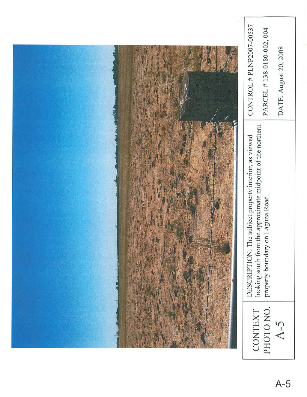
13 In order to avoid direct impacts to owls, no activity shall take place within 160 feet of an active burrow from September 1 to January 31 (wintering season) or 250 feet from February 1 through August 31 (breeding season). Protective fencing shall be placed, at the distances above, around the active burrows and no activity shall occur within the protected buffer areas. Any impact to active owl burrows, relocation of owls or mitigation for habitat loss shall be done in accordance with CDFG guidelines. Written evidence from CDFG staff shall be provided to DERA attesting to the permission to remove burrows, relocate owls, mitigate for lost habitat, and provided a method for preservation habitat in perpetuity. 25. Mitigation Measure E: Cultural Resources Should any cultural resources, such as structural features, unusual amounts of bone or shell, artifacts, human remains, or architectural remains be encountered during any development activities, work shall be suspended and DERA shall be immediately notified by calling (916) At that time, DERA will coordinate any necessary investigation of the find with appropriate specialists as needed. The project proponent shall be required to implement any mitigation deemed necessary for the protection of the cultural resources. In addition, pursuant to Section of the State Public Resources Code and Section of the State Health and Safety Code, in the event of the discovery of human remains, all work is to stop and the County Coroner shall be immediately notified. If the remains are determined to be Native American, guidelines of the Native American Heritage Commission shall be adhered to in the treatment and disposition of the remains. Mitigation Measure Compliance: Comply with the MMRP for this project as follows: 26. The project proponent shall comply with the MMRP for this project, including the payment of a fee to cover the DERA staff costs incurred during implementation of the MMRP. The MMRP fee for this project is $2, This fee includes administrative costs of $ Until the MMRP has been recorded and the administrative portion of the MMRP fee has been paid, no final parcel map for the subject property shall be approved. Until the balance of the MMRP fee has been paid, no encroachment, grading, building, sewer connection, water connection or occupancy permit from Sacramento County shall be approved. IV. ATTACHMENTS A. Context Photos (5) srplnp
14 V. EXHIBITS 1. Tentative Parcel Map VI. CPAC REFERRAL This staff report was prepared on April 3, This staff report was updated on May 7, srplnp
15
16
17
18
19
20
21
COUNTY OF SACRAMENTO CALIFORNIA PLANNING COMMISSION REPORT
 COUNTY OF SACRAMENTO CALIFORNIA PLANNING COMMISSION REPORT Control No.: PLNP2012-00140 Type: PMR-EXR TO: FROM: COUNTY PLANNING COMMISSION DEPARTMENT OF COMMUNITY DEVELOPMENT CONTACT: Christopher Castorena,
COUNTY OF SACRAMENTO CALIFORNIA ZONING ADMINISTRATOR REPORT
 COUNTY OF SACRAMENTO CALIFORNIA ZONING ADMINISTRATOR REPORT Control No.: PLNP2011-00104 Type: UPZ TO: FROM: ZONING ADMINISTRATOR COMMUNITY DEVELOPMENT DEPARTMENT CONTACT: Carol Gregory, Planner III, (916)
COUNTY OF SACRAMENTO CALIFORNIA SUBDIVISION REVIEW COMMITTEE REPORT
 COUNTY OF SACRAMENTO CALIFORNIA SUBDIVISION REVIEW COMMITTEE REPORT Control No.: PLNP2013-00066 Type: UPP TO: FROM: SUBDIVISION REVIEW COMMITTEE DEPARTMENT OF COMMUNITY DEVELOPMENT CONTACT: Carol Gregory,
COUNTY OF SACRAMENTO CALIFORNIA ZONING ADMINISTRATOR REPORT
 COUNTY OF SACRAMENTO CALIFORNIA ZONING ADMINISTRATOR REPORT Control No.: PLNP2012-00058 Type: VAZ TO: FROM: ZONING ADMINISTRATOR DEPARTMENT OF COMMUNITY DEVELOPMENT CONTACT: Rebecca Boschee, Planner, 874-3104;
COUNTY OF SACRAMENTO CALIFORNIA ZONING ADMINISTRATOR REPORT
 COUNTY OF SACRAMENTO CALIFORNIA ZONING ADMINISTRATOR REPORT For the Agenda of: May 4, 2016 To: From: Subject: Supervisorial District(s): Zoning Administrator Department of Community Development PLNP2015-00222.
REPORT TO PLANNING AND DESIGN COMMISSION City of Sacramento
 REPORT TO PLANNING AND DESIGN COMMISSION City of Sacramento 915 I Street, Sacramento, CA 95814-2671 www.cityofsacramento.org 9 PUBLIC HEARING December 10, 2015 To: Members of the Planning and Design Commission
Planning Commission Staff Report August 6, 2015
 Commission Staff Report August 6, 2015 Project: Capital Reserve Map File: EG-14-008A Request: Tentative Parcel Map Location: 8423 Elk Grove Blvd. APN: 116-0070-014 Staff: Christopher Jordan, AICP Sarah
COUNTY OF SACRAMENTO CALIFORNIA PLANNING COMMISSION REPORT
 COUNTY OF SACRAMENTO CALIFORNIA PLANNING COMMISSION REPORT For the Agenda of: September 12, 2016 To: From: Subject: County Planning Commission Department Of Community Development PLNP2016-00179. Willman
Prepared by: Nick Lagura, Associate Planner
 CITY OF CITRUS HEIGHTS PLANNING DIVISION STAFF REPORT PLANNING COMMISSION MEETING May 25, 2016 Prepared by: Nick Lagura, Associate Planner REQUEST The applicant requests approval of a Tentative Parcel
FOR OFFICE USE ONLY Date Submitted Received By Fees Paid $ Receipt No. Received By Application No. Application Complete Final Action Date
 COMMERCIAL, INDUSTRIAL, & MANUFACTURING SITE PLAN (CIM) APPLICATION Mariposa County Planning Department 5100 Bullion Street, P.O. Box 2039 Mariposa, CA 95338 Telephone (209) 966-5151 FAX (209) 742-5024
CHAPTER 3 PRELIMINARY PLAT
 10-3-1 10-3-3 SECTION: CHAPTER 3 PRELIMINARY PLAT 10-3-1: Consultation 10-3-2: Filing 10-3-3: Requirements 10-3-4: Approval 10-3-5: Time Limitation 10-3-6: Grading Limitation 10-3-1: CONSULTATION: Each
TENTATIVE MAP INFORMATION SHEET
 TENTATIVE MAP INFORMATION SHEET GENERAL INFORMATION This information sheet explains how your Tentative Map application will be processed, what fees you must pay, and what plans you must submit. If you
1. The reason provided for the opposing votes was that the two commissioners wanted something else to be developed on their parcel.
 Agenda Item #6.2 SUBJECT: PUBLIC HEARING - APPEAL OF PLANNING COMMISSION DECISION DENYING THE APPROVAL OF THE TENTATIVE PARCEL MAP, CONDITIONAL USE PERMIT, AND SITE AND ARCHITECTURAL REVIEW FOR THE CONSTRUCTION
APPLICATION PROCESSING STEPS STEP 1 CHECK WITH STAFF
 APPLICATION PROCESSING STEPS STEP 1 CHECK WITH STAFF - Development Services Staff will explain the requirements and procedures to you. However, before filing an application with the Community Development
March 26, Sutter County Planning Commission
 March 26, 2003 To: Re: Sutter County Planning Commission Agenda Item #12: Public hearing on Rezoning #03-04 to change the zoning classification of two parcels totaling 324+ acres from the AG (General Agricultural)
REPORT TO PLANNING AND DESIGN COMMISSION City of Sacramento
 REPORT TO PLANNING AND DESIGN COMMISSION City of Sacramento 915 I Street, Sacramento, CA 95814-2671 www.cityofsacramento.org 4 PUBLIC HEARING June 25, 2015 Members of the Planning Commission Subject: Greenfair
CITY OF CORNING TENTATIVE MAPS
 CITY OF CORNING TENTATIVE MAPS APPLICANT S GUIDE TO PROCEDURES WHAT IS A TENTATIVE MAP? A division of land for the purpose of sale, lease, or finance requires submittal of a map for City approval showing
APPLICATION PROCESSING. CHECK WITH STAFF - Development Services Staff will explain the requirements and procedures to you.
 PLANNED DEVELOPMENT ZONE 1810 E. HAZELTON AVENUE, STOCKTON CA 95205 BUSINESS PHONE: (209) 468-3121 Business Hours: 8:00 a.m. to 5:00 p.m. (Monday through Friday) STEP 1 STEP 2 FEE FORM DEED SERVICES APPLICATION
APPLICATION PROCESSING
 MAJOR SUBDIVISION 1810 E. HAZELTON AVENUE, STOCKTON CA 95205 BUSINESS PHONE: (209) 468-3121 BUSINESS HOURS: 8:00 A.M. TO 5:00 P.M..(Monday through Friday) APPLICATION PROCESSING STEPS STEP 1 STEP 2 CHECK
292 West Beamer Street Woodland, CA (530) FAX (530)
 FAX (530)") - County of Yolo PLANNING AND PUBLIC WORKS DEPARTMENT John Bencomo DIRECTOR 292 West Beamer Street Woodland, CA 95695-2598 (530) 666-8775 FAX (530) 666-8728 www.yolocounty.org PLANNING COMMISSION STAFF
- County of Yolo PLANNING AND PUBLIC WORKS DEPARTMENT John Bencomo DIRECTOR 292 West Beamer Street Woodland, CA 95695-2598 (530) 666-8775 FAX (530) 666-8728 www.yolocounty.org PLANNING COMMISSION STAFF
Project File #: SF Project Name: Jackson Ranch Filing No. 4 Parcel Nos.: , and
 COMMISSIONERS: DARRYL GLENN (PRESIDENT) MARK WALLER (PRESIDENT PRO TEMPORE) STAN VANDERWERF LONGINOS GONZALEZ PEGGY LITTLETON PLANNING AND COMMUNITY DEVELOPMENT DEPARTMENT CRAIG DOSSEY, EXECUTIVE DIRECTOR
CITY OF ELK GROVE CITY COUNCIL STAFF REPORT
 CITY OF ELK GROVE CITY COUNCIL STAFF REPORT AGENDA ITEM NO. 9.3 AGENDA TITLE: A public hearing to consider a General Plan Amendment, Specific Plan Amendment, Rezone, Tentative Subdivision Map, Abandonment
FEE The staff will let you know the current cost of filing an application. Make checks payable to the San Joaquin County Treasurer.
 VARIANCE 1810 E. HAZELTON AVENUE, STOCKTON CA 95205 BUSINESS PHONE: (209) 468-3121 Business Hours: 8:00 a.m. to 5:00 p.m. (Monday through Friday) STEP 1 STEP 2 APPLICATION PROCESSING STEPS CHECK WITH STAFF
RESOLUTION NO. FILE NO. PT14-047
 RESOLUTION NO. A RESOLUTION OF THE COUNCIL OF THE CITY OF SAN JOSE APPROVING A VESTING TENTATIVE MAP TO SUBDIVIDE ONE (1) LOT INTO NINE (9) LOTS FOR RESIDENTIAL USES, AND ONE (1) LOT FOR COMMON USES ON
1.0 REQUEST. SANTA BARBARA COUNTY ZONING ADMINISTRATOR Coastal Zone Staff Report for Vincent New Single-Family Dwelling & Septic System
 SANTA BARBARA COUNTY ZONING ADMINISTRATOR Coastal Zone Staff Report for Vincent New Single-Family Dwelling & Septic System Hearing Date: February 26, 2007 Supervisorial District: First Staff Report Date:
HOW TO APPLY FOR A USE PERMIT
 HOW TO APPLY FOR A USE PERMIT MENDOCINO COUNTY PLANNING AND BUILDING SERVICES What is the purpose of a use permit? Throughout the County, people use their properties in many different ways. They build
Larimer County Planning Dept. Procedural Guide for 1041 PERMITS
 - Larimer County Planning Dept. Procedural Guide for 1041 PERMITS PLEASE NOTE: A PRE-APPLICATION CONFERENCE IS REQUIRED PRIOR TO SUBMITTING THIS APPLICATION. PURPOSE: State Statutes allow local governments
WASCO COUNTY PRELIMINARY SUBDIVISION APPLICATION
 WASCO COUNTY PRELIMINARY SUBDIVISION APPLICATION DETAILED SPECIFIC WRITTEN REQUEST File Number: SDV- Number of Proposed Lots & their Dimensions: PRELIMINARY SUBDIVISION PLAN REQUIREMENTS The approval of
APPLICATION SUBMITTAL REQUIREMENTS FOR Tentative Parcel or Subdivision Maps
 CITY OF EL CERRITO Community Development Department Planning and Building Division 10890 San Pablo Avenue, El Cerrito, CA 94530 (510) 215-4330 FA (510) 233-5401 planning@ci.el-cerrito.ca.us APPLICATION
820 BEL MARIN KEYS BOULEVARD, NOVATO ASSESSOR'S PARCEL * * * * * * * * * * * * * * * * * * * * * * * *
 ORDINANCE NO. ORDINANCE OF THE MARIN COUNTY BOARD OF SUPERVISORS AMENDING TITLE 22 OF THE MARIN COUNTY CODE, THEREBY APPROVING THE COUNTY-INITIATED REZONING (RZ 06-01) FOR THE BRAHMA KUMARIS WORLD SPIRITUAL
APPLICATION PROCEDURE
 ANTRIM PLANNING BOARD P. O. Box 517 Antrim, New Hampshire 03440 Phone: 603-588-6785 FAX: 603-588-2969 APPLICATION FORM AND CHECKLIST FOR MINOR OR MAJOR SITE PLAN REVIEW File Date Received By APPLICATION
Chapter 100 Planned Unit Development in Corvallis Urban Fringe
 100.100 Scope and Purpose. Chapter 100 Planned Unit Development in Corvallis Urban Fringe (1) All applications for land divisions in the Urban Residential (UR) and Flood Plain Agriculture (FPA) zones within
Guide to Combined Preliminary and Final Plats
 Guide to Combined Preliminary and Final Plats Introduction The Douglas County is committed to providing open, transparent application processes to the public. This Guide is provided to assist anyone interested
Residential Project Convenience Facilities
 Standards for Specific Land Uses 35.42.220 E. Findings. The review authority shall approve a Land Use Permit in compliance with Subsection 35.82.110.E (Findings required for approval) or a Conditional
Tentative Map Application Review Procedures
 FOR REFERENCE ONLY This page is not part of the application. Tentative Map Application Review Procedures The tentative map process in Churchill County is designed to provide a mechanism in order to divide
Napa County Planning Commission Board Agenda Letter
 Agenda Date: 9/20/2017 Agenda Placement: 8C Napa County Planning Commission Board Agenda Letter TO: FROM: Napa County Planning Commission Charlene Gallina for David Morrison - Director Planning, Building
Prepared by: Casey Kempenaar, Senior Planner
 CITY OF CITRUS HEIGHTS PLANNING DIVISION STAFF REPORT PLANNING COMMISSION MEETING January 27, 2016 Prepared by: Casey Kempenaar, Senior Planner REQUEST The applicant requests approval of a Tentative Parcel
610 LAND DIVISIONS AND PROPERTY LINE ADJUSTMENTS OUTSIDE A UGB
 ARTICLE VI: LAND DIVISIONS AND PROPERTY LINE ADJUSTMENTS VI-21 610 LAND DIVISIONS AND PROPERTY LINE ADJUSTMENTS OUTSIDE A UGB 610-1 Property Line Adjustments (Property Line Relocation) A property line
5. That the Owner shall agree that all development Blocks shown within the Draft Plan will be connected to full municipal services.
 Conditions Relating to Draft Plan of Subdivision Approval East Fonthill 26T 01014 (Draft Plan dated December 1, 2013, and revised August 28, 2014), the Town of Pelham 1. This approval applies to the Draft
COUNTY OF SAN MATEO PLANNING AND BUILDING DEPARTMENT
 COUNTY OF SAN MATEO PLANNING AND BUILDING DEPARTMENT DATE: April 16, 2015 TO: FROM: Zoning Hearing Officer Planning Staff SUBJECT: Consideration of a Coastal Development Permit and Planned Agricultural
BEFORE THE HEARING EXAMINER FOR THURSTON COUNTY
 COUNTY COMMISSIONERS Cathy Wolfe District One Diane Oberquell District Two Robert N. Macleod District Three HEARING EXAMINER BEFORE THE HEARING EXAMINER FOR THURSTON COUNTY In the Matter of the Application
BY BOARD OF COUNTY COMMISSIONERS AN ACT TO BE ENTITLED
 BY BOARD OF COUNTY COMMISSIONERS ORDINANCE NO. AN ACT TO BE ENTITLED AN ORDINANCE AMENDING THE PASCO COUNTY LAND DEVELOPMENT CODE, ARTICLE 700, BY REPEALING EXISTING SECTION 702, ENVIRONMENTALLY SENSITIVE
 As Amended by the Planning Commission June 16, 2005 CONDITIONS OF APPROVAL TENTATIVE PARCEL MAP APPLICATION NO. 2002-28 NANCY ABDALLAH Department of Public Works 1. The recorded parcel map shall be prepared
MS MINOR SUBDIVISION TREVITHICK
 MS-02-015 341.12 MINOR SUBDIVISION TREVITHICK A request by Danny Trevithick for a one-lot Minor Subdivision on five acres. The property is zoned A-35 (Agricultural) District and is located ¼ mile south
Trio Petroleum, Inc. (PLN010302)
") LYNNE MOUNDAY ZONING ADMINISTRATOR STATE OF CALIFORNIA COUNTY OF MONTEREY RESOLUTION NO. 010302 A.P.# 424-091-021-000 In the matter of the application of Trio Petroleum, Inc. (PLN010302) FINDINGS & DECISION
LYNNE MOUNDAY ZONING ADMINISTRATOR STATE OF CALIFORNIA COUNTY OF MONTEREY RESOLUTION NO. 010302 A.P.# 424-091-021-000 In the matter of the application of Trio Petroleum, Inc. (PLN010302) FINDINGS & DECISION
Kitsap County Department of Community Development. Staff Report and Administrative Decision
 Kitsap County Department of Community Development Report Date: Staff Report and Administrative Decision Application Complete Date: March 19, 2018 Application Submittal Date: March 19, 2018 To: Seth Hanson,
SANTA BARBARA COUNTY ZONING ADMINISTRATOR STAFF REPORT November 20, 2015
 SANTA BARBARA COUNTY ZONING ADMINISTRATOR STAFF REPORT November 20, 2015 PROJECT: Acquistapace Tentative Parcel Map HEARING DATE: December 7, 2015 STAFF/PHONE: Dana Eady, (805) 934-6266 GENERAL INFORMATION
ARTICLE 9 SPECIFICATIONS FOR DOCUMENTS TO BE SUBMITTED
 ARTICLE 9 SPECIFICATIONS FOR DOCUMENTS TO BE SUBMITTED SECTION 950 GENERALLY All applications shall be properly signed and filed by the owner or, with the owner s specific written consent, a contract purchaser
PUTNAM COUNTYCOMPREHENSIVE PLAN
 COMPREHENSIVE PLAN EXHIBIT AA COMPREHENSIVE PLAN A. Future Land Use Element Goals, Objectives, Policies This section proposed objectives and policies, which will assist Putnam County Commissioners and
TENTATIVE MAP APPLICATION GUIDE (BCC 20-1)( 20-2 to )( to 20-91)( to )
( 20-2 to )( to 20-91)( to )") Butte County Department of Development Services PERMIT CENTER 7 County Center Drive, Oroville, CA 95965 Planning Division Phone 530.552.3701 Fax 530.538.7785 Email dsplanning@buttecounty.net FORM NO PLG-05
Butte County Department of Development Services PERMIT CENTER 7 County Center Drive, Oroville, CA 95965 Planning Division Phone 530.552.3701 Fax 530.538.7785 Email dsplanning@buttecounty.net FORM NO PLG-05
MEMORANDUM. TERESA McCLISH, COMMUNITY DEVELOPMENT DIRECTOR
 MEMORANDUM TO: FROM: BY: PLANNING COMMISSION TERESA McCLISH, COMMUNITY DEVELOPMENT DIRECTOR MATTHEW DOWNING, ASSISTANT PLANNER SUBJECT: CONSIDERATION OF TENTATIVE PARCEL MAP CASE NO. 14-002; SUBDIVISION
MINUTE ORDER BONNER COUNTY COMMISSIONERS PUBLIC HEARING MINUTES AUGUST 6, 2015
 MINUTE ORDER BONNER COUNTY COMMISSIONERS PUBLIC HEARING MINUTES AUGUST 6, 2015 CALL TO ORDER: Chair Cary Kelly called the Bonner County Commissioners hearing to order at 1:00 p.m. in the 3rd floor meeting
MINOR BOUNDARY LINE ADJUSTMENT PROCESS GUIDE
 MINOR BOUNDARY LINE ADJUSTMENT PROCESS GUIDE Clear Creek County Planning Department P.O. Box 2000 Georgetown, Colorado 80444 (303) 679-2436 phone (303) 569-1103 fax 1 PURPOSE To establish criteria and
CITY OF WINTERS HABITAT MITIGATION PROGRAM
 CITY OF WINTERS HABITAT MITIGATION PROGRAM The City currently faces oversight of the implementation of various habitat mitigation requirements associated with recently approved and pending development
APPLICATION. Telephone Fax Address. Telephone Fax Address FOR MARTIN COUNTY USE ONLY
 APPLICATION PRESERVE AREA MANAGEMENT PLAN/ ABBREVIATED PRESERVE AREA MANAGEMENT PLAN Growth Management Department Environmental Division PART 1: Applicant Information A. Land Owner(s) Name Title and Company
CITY OF RIO VISTA PLANNING COMMISSION STAFF REPORT
 MEETING DATE: January10, 2018 CITY OF RIO VISTA PLANNING COMMISSION STAFF REPORT AGENDA ITEM #4.2 PREPARED BY: Lamont Thompson, Planning Manager SUBJECT: Vesting Tentative Tract No. 2017-001: To consider
3. Twelve additional letters of support submitted by the Applicant.
 M E M O TO: CHAIR TRZESNIEWSKI, MEMBERS OF THE PLANNING COMMISSION FROM: KEN MACNAB, PLANNING MANAGER DATE: MAY 5, 2016 SUBJECT: ITEM 7.D. DJ s GROWING PLACE Please find enclosed the following documents:
DOUGLAS COUNTY SUBDIVISION RESOLUTION Article 4 Preliminary Plan 10/13/2015
 ARTICLE 4 PRELIMINARY PLAN 401 Intent An in-depth analysis of the proposed subdivision, including a review of the design considering the ability to obtain water and sanitation, identified geologic hazards,
Peter Pan Investors LLC (PLN030397)
") PLANNING COMMISSION COUNTY OF MONTEREY, STATE OF CALIFORNIA RESOLUTION NO. 04014 A. P. # 241-201-022-000 241-201-023-000 In the matter of the application of Peter Pan Investors LLC (PLN030397) FINDINGS
PLANNING COMMISSION COUNTY OF MONTEREY, STATE OF CALIFORNIA RESOLUTION NO. 04014 A. P. # 241-201-022-000 241-201-023-000 In the matter of the application of Peter Pan Investors LLC (PLN030397) FINDINGS
SKETCH PLAN REVIEW SPECIAL EXCEPTION, SPECIAL REVIEW,
 www.larimer.org Planning Department 200 W. Oak Street 3 rd Floor Fort Collins, CO 80521 970-498-7683 SKETCH PLAN REVIEW SKETCH PLAN REVIEW for Conservation Developments, Planned Land Divisions, Subdivisions,
A. Maintenance. All legally established, nonconforming structures can be maintained (e.g., painting and repairs);
;") Chapter 24.50 NONCONFORMING USES, STRUCTURES AND LOTS Sections: 24.50.010 Nonconforming uses, structures, and lots Purpose. 24.50.020 Nonconforming uses, structures, and lots Alteration or expansion of
Chapter 24.50 NONCONFORMING USES, STRUCTURES AND LOTS Sections: 24.50.010 Nonconforming uses, structures, and lots Purpose. 24.50.020 Nonconforming uses, structures, and lots Alteration or expansion of
CHARLES CITY COUNTY SITE PLAN ORDINANCE. This Ordinance shall be known as the Charles City County Site Plan Ordinance.
 CHARLES CITY COUNTY SITE PLAN ORDINANCE Section 1. Title This Ordinance shall be known as the Charles City County Site Plan Ordinance. Section 2. Authority. This Ordinance is enacted pursuant to the authority
Walton County Planning and Development Services
 Walton County Planning and Development Services 31 Coastal Centre Boulevard, Suite 100 47 N 6 th Street Santa Rosa Beach, Florida 32459 DeFuniak Springs, Florida 32433 Phone 850-267-1955 Phone 850-892-8157
PLANNING & ZONING COMMISSION RESOLUTION A RESOLUTION OF THE PLANNING COMMISSION OF THE CITY OF ALBANY, COUNTY
 PLANNING & ZONING COMMISSION RESOLUTION 0-0 A RESOLUTION OF THE PLANNING COMMISSION OF THE CITY OF ALBANY, COUNTY OF ALAMEDA, STATE OF CALIFORNIA, APPROVING A TENTATIVE PARCEL MAP TO CREATE A PARCEL AT
Umatilla County Department of Land Use Planning
 Umatilla County Department of Land Use Planning 216 SE 4 th ST, Pendleton, OR 97801, (541) 278-6252 PROCESSING TYPE I & III APPLICATIONS Land Division, Type I - IV Supplemental Application & Information
ARTICLE 7: PLOT PLANS AND SITE PLAN REQUIREMENTS AND REVIEW
 ARTICLE 7: PLOT PLANS AND SITE PLAN REQUIREMENTS AND REVIEW Section 7.0 - Purpose The purpose of this article is to specify the documents and/or drawings required for a Site Plan Review or a Plot Plan
4.2 LAND USE INTRODUCTION
 4.2 LAND USE INTRODUCTION This section of the EIR addresses potential impacts from the Fresno County General Plan Update on land use in two general areas: land use compatibility and plan consistency. Under
MAJOR BOUNDARY LINE ADJUSTMENT PROCESS GUIDE
 MAJOR BOUNDARY LINE ADJUSTMENT PROCESS GUIDE Clear Creek County Planning Department P.O. Box 2000 Georgetown, Colorado 80444 (303) 679-2436 - phone (303) 569-1103 - fax PURPOSE To establish criteria and
APPLICATION PROCEDURE
 ANTRIM PLANNING BOARD P. O. Box 517 Antrim, New Hampshire 03440 Phone: 603-588-6785 FAX: 603-588-2969 APPLICATION FORM AND CHECKLIST FOR EARTH EXCAVATION AND RECLAMATION File # Date Received By APPLICATION
Open Space Model Ordinance
 Open Space Model Ordinance Section I. Background Open space development has numerous environmental and community benefits, including: 1) Reduces the impervious cover in a development. Impervious cover
Date Received: Application Complete? YES / NO
 OFFICE USE ONLY Section 22 (Official Plan Amendment) Section 34 (Zoning Amendment), Section 36 (Holding Zone Removal), Section 41 (Site Plan Approval) and Section 45 (Minor Variance) of the Planning Act
CITRUS HEIGHTS COMMUNITY SPECIAL PLANNING AREA
 CITRUS HEIGHTS COMMUNITY SPECIAL PLANNING AREA 501-90. INTENT. It is the intent of the Board of Supervisors in adopting this Special Planning Area Ordinance to allow development on the property described
Guide to Preliminary Plans
 Guide to Preliminary Plans Introduction The Douglas County is committed to providing open, transparent application processes to the public. This Guide is provided to assist anyone interested in the procedures
Conceptual Scheme SE W4
 December 2012 1. PURPOSE 1.1. The purpose of a Conceptual Scheme (CS) is as follows: a) To provide a framework for the subsequent subdivision and/or development of land within the Country Residential Policy
FINAL SITE PLAN PLAT APPLICATION Town of Apex, North Carolina
 FINAL SITE PLAN PLAT APPLICATION Town of Apex, North Carolina This document is a public record under the North Carolina Public Records Act and may be published on the Town s website or disclosed to third
Town of Lisbon, Maine SUBDIVISION REVIEW APPLICATION
 Date Received: Fee Paid (amount): Applicant: Town of Lisbon, Maine SUBDIVISION REVIEW APPLICATION Subdivision Name/Title: This application must be received at the Town Office by close of business on the
Taos County Planning Department COMMERCIAL/ADMINISTRATIVE/SPECIAL USE APPLICATION
 PERMIT FEE: $250.00 Taos County Planning Department COMMERCIAL/ADMINISTRATIVE/SPECIAL USE APPLICATION Application No. FOR OFFICIAL USE ONLY SELECT THE USE TYPE OF COMMERCIAL ZONING CLEARANCE FOR REVIEW
TRANSFERABLE DEVELOPMENT RIGHTS PROCESS GUIDE
 TRANSFERABLE DEVELOPMENT RIGHTS PROCESS GUIDE Clear Creek County Planning Department P.O. Box 2000 Georgetown, Colorado 80444 (303) 679-2436 - phone (303) 569-1103 - fax 1 PURPOSE: A Transfer of Development
Planning Commission Hearing Date: 2/21/2017 Board of County Commissioners Hearing Date: 3/8/2017
 COMMISSIONERS: DARRYL GLENN (PRESIDENT) MARK WALLER (PRESIDENT PRO TEMPORE) STAN VANDERWERF LONGINOS GONZALEZ PEGGY LITTLETON PLANNING AND COMMUNITY DEVELOPMENT DEPARTMENT CRAIG DOSSEY, EXECUTIVE DIRECTOR
TOWN OF ORO VALLEY PLANNING & ZONING COMMISSION MEETING DATE: December 6, 2011
 PLANNING & ZONING COMMISSION MEETING DATE: December 6, 2011 TO: FROM: SUBJECT: PLANNING & ZONING COMMISSION Matt Michels, Senior Planner mmichels@orovalleyaz.gov; tel. 229-4822 Public Hearing: Rancho de
PALM BEACH COUNTY PLANNING, ZONING AND BUILDING DEPARTMENT ZONING DIVISION
 PALM BEACH COUNTY PLANNING, ZONING AND BUILDING DEPARTMENT ZONING DIVISION Petition No.: Z2002-051 Petitioner: Rene & Gina Tercilla Owner: Rene & Gina Tercilla Agent: Rene & Gina Tercilla Telephone No.:
ARTICLE 24 SITE PLAN REVIEW
 ARTICLE 24 SITE PLAN REVIEW 24.1 PURPOSE: The intent of these Ordinance provisions is to provide for consultation and cooperation between the land developer and the Township Planning Commission in order
CHECKLIST FOR DEVELOPMENT REVIEW
 CHECKLIST FOR DEVELOPMENT REVIEW Petitions and related documents and plans for land development or other proposals regulated by Title 16 of the Municipal Code (Development Ordinance) and Title 17 of the
APPLICATION FOR PERMIT: (Pursuant to Ord & Reso ) 4d Habitat Loss Permit Vegetation Removal Tree Removal. Address:
 4d Habitat Loss Permit Vegetation Removal Tree Removal. Address:") CITY OF ESCONDIDO Planning Division 201 North Broadway Escondido, CA 92025-2798 (760) 839-4671 Fax: (760) 839-4313 APPLICATION FOR PERMIT: (Pursuant to Ord. 91-54 & Reso. 94-436) Case No: FOR INTERNAL
CITY OF ESCONDIDO Planning Division 201 North Broadway Escondido, CA 92025-2798 (760) 839-4671 Fax: (760) 839-4313 APPLICATION FOR PERMIT: (Pursuant to Ord. 91-54 & Reso. 94-436) Case No: FOR INTERNAL
Group Sewer Only** 80 Ft Frontage* 20,000 Sq. Ft. (.46 acre) Minimum** 120 Ft Frontage* 20,000 Sq. Ft. (.46acre) Minimum** 150 Ft Frontage*
 Minimum** 120 Ft Frontage* 20,000 Sq. Ft. (.46acre) Minimum** 150 Ft Frontage*") Residential Lots Minimum Chart The minimum lot size of any minor subdivision where there is no public sewers shall be as shown below or as required by township zoning and/or the Tuscarawas General Health
Residential Lots Minimum Chart The minimum lot size of any minor subdivision where there is no public sewers shall be as shown below or as required by township zoning and/or the Tuscarawas General Health
APPLICATION CHECKLIST
 DEPARTMENT OF PLANNING AND COMMUNITY DEVELOPMENT 1010 10TH Street, Suite 3400, Modesto, CA 95354 Phone: 209.525.6330 Fax: 209.525.5911 Form Available Online: http://www.stancounty.com/planning/applications.shtm
Planning Justification Report
 Planning Justification Report, Township of Puslinch FARHI HOLDINGS CORPORATION Updated January 27, 2017 Zelinka Priamo Ltd. Page i TABLE OF CONTENTS Page No. 1.0 1.1 1.2 1.3 2.0 2.1 2.2 2.3 2.4 2.5 3.0
Article 2 Application Type and Standards Requirements
 Article 1 Article 2 Division 1 Application Type and Standards Requirements General Provisions Sec. 2.1.1 Division 2 Division 3 Division 4 Division 5 Division 6 Division 7 Division 8 Division 9 Sec. 2.9.1
Land Use Application
 Land Use Application Check all permits you are applying for in the boxes provided. Submit this application form, the applicable materials listed in the corresponding permit application packet(s) and application
CITY OF SACRAMENTO COMMUNITY DEVELOPMENT DEPARTMENT ZONING ADMINISTRATOR 300 Richards Blvd, 3rd Floor, Sacramento, CA 95811
 CITY OF SACRAMENTO COMMUNITY DEVELOPMENT DEPARTMENT ZONING ADMINISTRATOR 300 Richards Blvd, 3rd Floor, Sacramento, CA 95811 ACTION OF THE ZONING ADMINISTRATOR On Thursday, September 14, 2017, the Zoning
Letter of Intent May 2017 (Revised November 2017)
") THE BEACH AT WOODMOOR LETTER OF INTENT MAY 2017 (REVISED NOVEMBER 2017) OWNER/APPLICANT: CONSULTANT: Lake Woodmoor Holdings LLC N.E.S. Inc. 1755 Telstar Drive, Suite 211 619 North Cascade Avenue Colorado
THE BEACH AT WOODMOOR LETTER OF INTENT MAY 2017 (REVISED NOVEMBER 2017) OWNER/APPLICANT: CONSULTANT: Lake Woodmoor Holdings LLC N.E.S. Inc. 1755 Telstar Drive, Suite 211 619 North Cascade Avenue Colorado
GOVERNMENT CODE SECTION GOVERNMENT CODE SECTION 65302
 GOVERNMENT CODE SECTION 65300 65300. Each planning agency shall prepare and the legislative body of each county and city shall adopt a comprehensive, long-term general plan for the physical development
The City of Carlsbad Planning Division A REPORT TO THE PLANNING COMMISSION. Item No. P.C. AGENDA OF: March 16, 2011 Project Planner: Shannon Werneke
 The City of Carlsbad Planning Division A REPORT TO THE PLANNING COMMISSION Item No. 2 Application complete date: January 24, 2011 P.C. AGENDA OF: March 16, 2011 Project Planner: Shannon Werneke Project
MINOR & MAJOR SUBDIVISION APPLICATION
 TOW OF HOOKSETT APPLICATIO # DATE MIOR & MAJOR SUBDIVISIO APPLICATIO Application for: Completeness Map and Lot o. Public Hearing o. of Lots LOCATIO: (Specify Street Address) OWER: APPLICAT: ADDRESS: ADDRESS:
COUNTY OF SAN MATEO PLANNING AND BUILDING DEPARTMENT
 COUNTY OF SAN MATEO PLANNING AND BUILDING DEPARTMENT DATE: October 20, 2016 TO: FROM: Zoning Hearing Officer Planning Staff SUBJECT: Consideration of a Non-Conforming Use Permit, pursuant to Sections 6135
VARIANCE (Revised 03/11)
") EL DORADO COUNTY PLANNING SERVICES 2850 Fairlane Court, Placerville CA 95667 (530) 621-5355 fax: (530) 642-0508 http://www.edcgov.us/planning VARIANCE (Revised 03/11) PURPOSE Each zone district establishes
EL DORADO COUNTY PLANNING SERVICES 2850 Fairlane Court, Placerville CA 95667 (530) 621-5355 fax: (530) 642-0508 http://www.edcgov.us/planning VARIANCE (Revised 03/11) PURPOSE Each zone district establishes
GENERAL PLAN, DEVELOPMENT CODE AND ZONING MAP AMENDMENT APPLICATION INFORMATION SHEET
 GENERAL PLAN, DEVELOPMENT CODE AND ZONING MAP AMENDMENT APPLICATION INFORMATION SHEET GENERAL INFORMATION This information sheet explains how an application requesting an amendment to the Truckee General
PLANNING COMMISSION STAFF REPORT June 18, 2015
 Community Development Department Planning Division 1600 First Street + P.O. Box 660 Napa, CA 94559-0660 (707) 257-9530 PLANNING COMMISSION STAFF REPORT June 18, 2015 AGENDA ITEM 7.B. PL15-0052 PM, GASSER
TOWN OF WHITBY REPORT RECOMMENDATION REPORT
 TOWN OF WHITBY REPORT RECOMMENDATION REPORT REPORT TO: Planning and Development Committee REPORT NO: PL 4-08 DATE OF MEETING: January 21, 2008 FILE NO(S): MI-01-07 (SW- 2002-03) PREPARED BY: Planning Department
Public Facilities and Finance Element
 This Element of the General Plan addresses the following public facilities issues: Water Service, including both potable (drinkable) and non-potable water delivery. Sewer Service, and Financing and construction