Landbase Accuracy with Cadastral Editor
|
|
|
- Nicholas Jordan
- 5 years ago
- Views:
Transcription


1 Landbase Accuracy with Cadastral Editor City Makes Enhancements for Improved Planning By Kristy M. Capobianco, GISP, RS&H Donald Terrell, GISP, City of Jacksonville Beach and William C. Mann, AICP, City of Jacksonville Beach SERUG: April 28, 2009
2 Project Background City of Jacksonville Beach in Northeast Florida Desired to Correct the Spatial and Attribute Inaccuracies in their Landbase and ROW Nearly 15,000 Parcels between Neptune Beach and Jacksonville Beach Major Problems with Inaccurate Landbase: Delays with Infrastructure Projects due to ROW Boundary Issues Disputes over Property Lines Issues with E911


:")


3 Project Location and Area Description Demographics City of Jacksonville Beach Area: 9.0 Square Miles Population (2000): 20,990 Neptune Beach Area: 2.45 Square Miles (Land) Population (2000): 7,270


4 Project Flowchart Data Clean-Up Field Data Collection AC: Convert Landbase Polylines to Arcs AM: Build Fabric Import Source Tool Points Created Polygons Created AC: Within Gdb Create New Cadastral Fabric Cadastral Fabric Import Fabric Data Import Control Pts
5 Project Flowchart Data Clean-Up Field Data Collection AC: Convert Landbase Polylines to Arcs AM: Build Fabric Import Source Tool Points Created Polygons Created AC: Within Gdb Create New Cadastral Fabric Cadastral Fabric Import Fabric Data Import Control Pts


6 Data Clean-Up Pseudo Nodes Arbitrary Nodes Located Along the Parcel Vertex Undershoots Parcel Line Doesn t Connect to Another Line (Leaving Gaps)


7 Data Clean-Up Overshoots Parcel Line is to Long (Leaving Dangling Nodes) Densified Arcs Sequence of Many Straight Lines to Make a Curve


8 Other Data Clean-Up Issues Inaccurate Parcel Splits/ Extra Parcel Lines Missing Parcels or Parcel Dimensions Parcel Size/Shape Issues
9 Project Flowchart Data Clean-Up Field Data Collection AC: Convert Landbase Polylines to Arcs AM: Build Fabric Import Source Tool Points Created Polygons Created AC: Within Gdb Create New Cadastral Fabric Cadastral Fabric Import Fabric Data Import Control Pts


10 Field Data Collection Divided Project Area into 14 Grid Sections Collected Minimum of 2 Points per Grid Section Trimble GeoXH handheld Benchmarks Fire Hydrants Light Poles Survey Control Points of Lot Corners


11 Cadastral Fabric Defined A cadastral fabric is a seamless parcel boundary network, which is created and maintained using data from survey records. Parcels are represented by parcel line features, parcel point features and parcel polygon features, referred to in aggregate as parcel features. Parcel topology in the cadastral fabric is stored explicitly through shared or common parcel point features. ESRI 2009:
12 Cadastral Fabric Defined 4 Methods for Adding Parcel Data into the Fabric: Migrate Existing Data Create New Parcels with the Parcel Traverse Build Parcels from Construction Lines Append Parcel Data from a Cadastral XML file
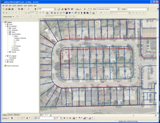
13 Cadastral Fabric Construction Data Clean-Up Field Data Collection AC: Convert Landbase Polylines to Arcs AM: Build Fabric Import Source Tool Points Created Polygons Created AC: Within Gdb Create New Cadastral Fabric Cadastral Fabric Import Fabric Data Import Control Pts

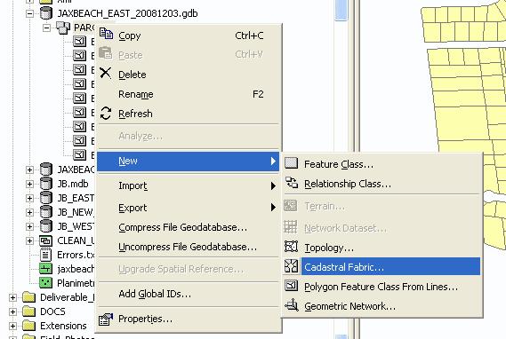

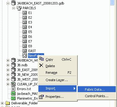


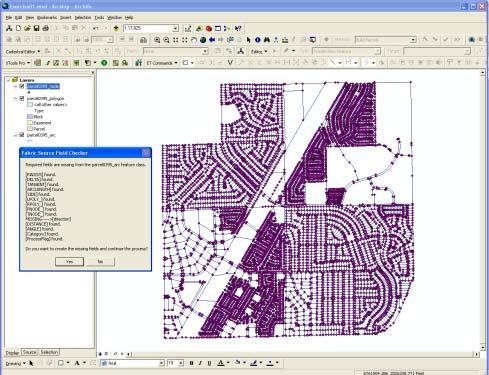

14 Cadastral Fabric Construction ArcMap Build Fabric Import Source Tool ArcCatalog


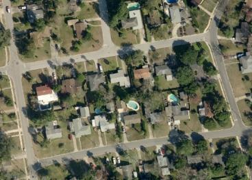
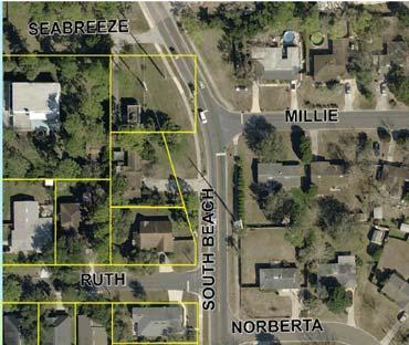
15 Parcel Rectification Datasets Parcel Annotation High-Resolution Aerials Existing Landbase Control Points and Survey Data Planimetric


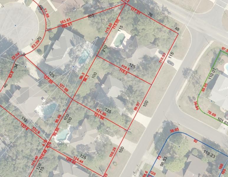
16 Identify Errors Parcel Rectification


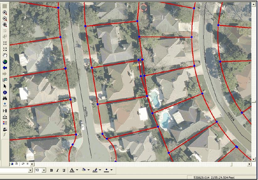
17 Parcel Rectification Discrepancies Located Start Edit Session Select Parcel Block Cadastral Editor Toolbar Modify Feature Select Parcels Unjoin Edit Dimensions Accept Changes Finish Job


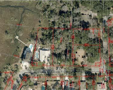
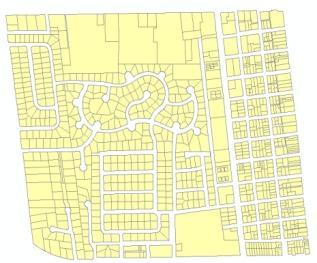
18 Parcel Rectification Comparison of Old Landbase to New Landbase


19 Parcel Rectification Corrected Parcels
20 Project Highlights Advanced Parcel Editing Tool Offers New Solution for Improving Property Line and Rightof-Way Information Incorporating GPS Benchmarks and Control Points Collected in the Field, the Team Improved Existing Parcel Information with their Known Locations and Dimensions Landbase Enhancements have led to Improved Planning and Public Safety Services for the City
21 Next Steps Incorporate Zoning Boundaries Interactive Web-Mapping Application Available to the Public Update Centerline Data Improved E911 Services Incorporate Electric Data
22 Thank You Questions/Comments Please Contact: Kristy M. Capobianco, GISP Reynolds, Smith and Hills, Inc Donald Terrell, GISP City of Jacksonville Beach William C. Mann, AICP City of Jacksonville Beach
A CADASTRAL GEODATA BASE FOR LAND ADMINISTRATION USING ARCGIS CADASTRAL FABRIC MODEL A CASE STUDY OF UWANI ENUGU, ENUGU STATE, NIGERIA
 A CADASTRAL GEODATA BASE FOR LAND ADMINISTRATION USING ARCGIS CADASTRAL FABRIC MODEL A CASE STUDY OF UWANI ENUGU, ENUGU STATE, NIGERIA BY Ndukwu, Raphael. Ike Department of Geoinformatics & Surveying University
ParcelMap BC Compiling a Parcel Fabric for the Province of British Columbia. Presented by: Ellen Styner (General Manager) and Wendy Amy (GIS Manager)
 and Wendy Amy (GIS Manager)") ParcelMap BC Compiling a Parcel Fabric for the Province of British Columbia Presented by: Ellen Styner (General Manager) and Wendy Amy (GIS Manager) Who is MNC? MNC is a geomatics engineering firm with
ParcelMap BC Compiling a Parcel Fabric for the Province of British Columbia Presented by: Ellen Styner (General Manager) and Wendy Amy (GIS Manager) Who is MNC? MNC is a geomatics engineering firm with
Presented by: Stewart Information International, Inc. Jack McKenna
 Presented by: Stewart Information International, Inc. Jack McKenna Held at the: 2007 ESRI Survey & Engineering GIS Summit San Diego Convention Center San Diego, California June 16-19, 2007 Integrating
City of Surrey s Digital Plan Submission Process
 City of Surrey s Digital Plan Submission Process Cadastral Update Karen Stewart, B.Tech. (GIS) Spatial Information Manager Peter Mueller, B.C.L.S., C.L.S. Survey Manager City of Surrey, British Columbia,
A Geocoded Cadastral Fabric as a Precondition for a Sustainable Land Management System
 A Geocoded Fabric as a Precondition for a Sustainable Land Management System Gottfried KONECNY, Germany; J.P. LAUZON, Canada; Abdul Salam MOHAMMED, India Key words: SDI,, Parcel Boundaries, GPS-GNSS, Land
Case Study - Management of Geospatial Cadastral Data Using Dedicated Products
 Case Study - Management of Geospatial Cadastral Data Using Dedicated Products ANA-CORNELIA BADEA Surveying and Cadastre Department Technical University of Civil Engineering Bucharest, Faculty of Geodesy
The Cadastral Modelling Future and The Land Surveyors Role
 The Cadastral Modelling Future and The Land Surveyors Role Ian Harper Geodata Australia ESRI Survey Summit July 2013 The Land Surveyors Future Role From Custodians of the Cadastre to Custodians of the
First Nations Land Registry
 First Nations Land Registry Making Sense of the ILRS Steven Patterson, Sitka Geomatics Inc. www.sitkageo.com Land Titles a brief history Land titles were traditionally managed within the community, and
The Survey Data Model Technology A practical survey solution to generate all levels of spatial and e-governance outcomes.
 Land Governance in a Rapidly Changing Environment Annual World Bank Conference on Land and Poverty April 24 & 25, 2012 The Survey Data Model Technology A practical survey solution to generate all levels
Parcel Fabric A Good Possibility for Management of Geospatial Cadastral Data
 Parcel Fabric A Good Possibility for Management of Geospatial Cadastral Data Ana-Cornelia Badea Abstract Parcel Fabric represents an ArcGIS extension to manage cadastral data. One of the main advantages
2018 Assessment Roll Edit Guide for Parcel-Level Geographical Information System (GIS) Information
 Information") 2018 Assessment Roll Edit Guide for Parcel-Level Geographical Information System (GIS) Information Florida Department of Revenue Property Tax Oversight January 2, 2018 Intended Users This edit guide is
2018 Assessment Roll Edit Guide for Parcel-Level Geographical Information System (GIS) Information Florida Department of Revenue Property Tax Oversight January 2, 2018 Intended Users This edit guide is
Capturing the Geographic Value of Living in 3-D3. Boulder County Assessor s s Office
 Capturing the Geographic Value of Living in 3-D3 Boulder County Assessor s s Office Introduction 2 In the city of Boulder, 25 of 37 plats in 2007 were for condos Condominiums are popping up all over Boulder
The New Technology of a Survey Data Model and Cadastral Fabric as the Foundation for a Future Land Administration System.
 The New Technology of a Survey Data Model and Cadastral Fabric as the Foundation for a Future Land Ian HARPER, Australia Key words: cadastral modelling, survey data model, Survey Accuracy, Cadastre 2014
Cadastral Framework Standards
 Cadastral Framework Standards The goal of the Data Standards and Recommendations Committee is to provide recommendations and guidelines to Indiana GIS user communities to facilitate the collection, maintenance
ParcelMap BC. Compiling a Parcel Fabric for the Province of British Columbia. WENDY AMY and ELLEN STYNER
 ParcelMap BC Compiling a Parcel Fabric for the Province of British Columbia WENDY AMY and ELLEN STYNER Who is MNC? Established in 1997, MNC is a geomatics engineering firm located in Calgary, Alberta.
GAUSSCAD A WEBGIS APPLICATION FOR COLLECTING CADASTRAL DATA
 M.M. Moise GaussCAD a WebGIS Application for Collecting Cadastral Data GAUSSCAD A WEBGIS APPLICATION FOR COLLECTING CADASTRAL DATA Mihai-Mircea MOISE, S.C. GAUSS S.R.L., mihai.moise@gauss.ro Abstract:
A Method For Building Legal Digital Cadastre Without Using Cadastral Measurements Field Book Data Is It Accurate Enough?
 A Method For Building Legal Digital Cadastre Without Using Cadastral Measurements Field Book Data Is It Jad JARROUSH, Dmitri BRICKMAN, Israel Key words: Digital Cadastre, Least Squares Cadastral Computations,
Delaware County Transfer Standards
 Delaware County Transfer Standards Delaware County Auditor David A. Yost Delaware County Engineer Chris Bauserman Adopted in 1997, Amended in 1999 Dave Yost County Auditor Chris Bauserman County Engineer
Cadastral Re-Alignment: Water Corporation approach to spatial data shifting
 Cadastral Re-Alignment: Water Corporation approach to spatial data shifting David Bulfield, Team Leader Spatial Systems Team, Spatial Information Management, Water Corporation (Western Australia) Justin
A Review and Perspective on Parcel Data Models for Urban Planning
 A Review and Perspective on Parcel Data Models for Urban Planning Yiqiang Ouyang Prof. Dr. Ilir Bejleri Department of Urban and Regional Planning University of Florida June 19-21, 2010 1 Content 1. Introduction
PREPARING SURVEY TENDER GIS DATABASE OUTCOMES
 PREPARING SURVEY TENDER SPECIFICATIONS FOR PROJECT GIS DATABASE OUTCOMES Presentation by Ian Harper GEODATA AUSTRALIA ESRI User Conference 2009 24 st July 2009 BACKGROUND GIS databases now provide a more
A FIRST ATTEMPT FOR USING VOLUNTEERED GEOGRAPHIC INFORMATION AND CROWD SOURCING TECHNIQUES IN CADASTRE
 A FIRST ATTEMPT FOR USING VOLUNTEERED GEOGRAPHIC INFORMATION AND CROWD SOURCING TECHNIQUES IN CADASTRE Sofia Basiouka National Technical University of Athens PhD student s.basiouka@gmail.com Chryssy Potsiou
GOVERNMENT. Case Study Ville de Trois Rivières streamlines property assessment
 GOVERNMENT Case Study Ville de Trois Rivières streamlines property assessment GIS-generated parcel basemap provides powerful visualization & analysis capabilities With a population of just over 130,000,
COUNCIL ACTION FORM SUBJECT: PLAT OF SURVEY (BOUNDARY LINE ADJUSTMENT) FOR 1404 BOSTON AVENUE AND 2230 PHILADELPHIA STREET
 FOR 1404 BOSTON AVENUE AND 2230 PHILADELPHIA STREET") ITEM # _29 DATE: 04-10-18 COUNCIL ACTION FORM SUBJECT: PLAT OF SURVEY (BOUNDARY LINE ADJUSTMENT) FOR 1404 BOSTON AVENUE AND 2230 PHILADELPHIA STREET BACKGROUND: The City s subdivision regulations are found
ITEM # _29 DATE: 04-10-18 COUNCIL ACTION FORM SUBJECT: PLAT OF SURVEY (BOUNDARY LINE ADJUSTMENT) FOR 1404 BOSTON AVENUE AND 2230 PHILADELPHIA STREET BACKGROUND: The City s subdivision regulations are found
Progress Report on Green Paper. Dr. Paddy Prendergast. on behalf of the. IIS Commission on Land Registration
 Progress Report on Green Paper By Dr. Paddy Prendergast on behalf of the IIS Commission on Land Registration Paddy Prendergast - Chair Brendan Sweeny - Hempenstall Surveys Paul Corrigan - P Corrigan Associates
LADM-based Crowdsourced 3D Cadastral Surveying Potential and Perspectives
 National Technical University Of Athens School of Rural and Surveying Engineering LADM-based Crowdsourced 3D Cadastral Surveying Potential and Perspectives Maria Gkeli, Surveying Engineer, PhD student
Keywords: Land Information System, Land Administration, Cadastre, Land Parcel
 Corporate-LIS for Effective Land Administration of Sri Lanka Nelson Wijenayake Senior Superintendent of Surveys, Survey Department of Sri Lanka nelsonwijenayake@gmail.com Abstract A drastic improvement
Land Tenure and Geospatial Data and Technology
 Land Tenure and Geospatial Data and Technology Ioana Bouvier E3/Land and Urban, USAID Senior Geospatial Analyst January 23, 2018 January 23, 2018 1 OUTLINE 1. Overview of geospatial data and technology
REQUEST FOR COMPETITIVE SEALED PROPOSALS
 HARRIS COUNTY APPRAISAL DISTRICT Harris County Houston, Texas BID DOCUMENTS BID NUMBER 2016-07 REQUEST FOR COMPETITIVE SEALED PROPOSALS GIS PARCEL FABRIC MIGRATION TECHNICAL SERVICES FOR THE HARRIS COUNTY
LRIMS Cadastre Module
 LRIMS Cadastre Module User Requirements and Functionality (Seychelles Case Study) John Latham, NRL Renato Cumani, NRL Luigi Simeone, NRL Summary Background User Requirements Business Model Application
Development of legislation for earthquake affected. cadastral boundaries in New Zealand. FIG Geoconference Cadastre 4.0, Coimbra Portugal
 Development of legislation for earthquake affected cadastral boundaries in New Zealand Associate Professor Dr Don Grant RMIT University FIG Geoconference Cadastre 4.0, Coimbra Portugal 26 October 2016
Spatial Data Warehouse Ltd. Cadastral Mapping INITIATIVE 1: CADASTRAL MAPPING. Version Spatial Data Warehouse Ltd. & AltaLIS Ltd.
 Spatial Data Warehouse Ltd. Initiative 1: Cadastral Mapping INITIATIVE 1: CADASTRAL MAPPING 29 P3 The SDW/AltaLIS Model Background The Government of Alberta started a mapping program, the Municipal Integrated
QUESTIONNAIRE. 1. Authorizing statute(s) citation West Virginia Code and 11-1C-4(d)
 citation West Virginia Code and 11-1C-4(d)") QUESTIONNAIRE (Please include a copy of this form with each filing of your rule: Notice of Public Hearing or Comment Period; Proposed Rule, and if needed, Emergency and Modified Rule.) DATE: 6/8/15 TO:
QUESTIONNAIRE (Please include a copy of this form with each filing of your rule: Notice of Public Hearing or Comment Period; Proposed Rule, and if needed, Emergency and Modified Rule.) DATE: 6/8/15 TO:
Egyptian Nationwide Title Cadastre System
 Kholoud SAAD, Egypt Key words: Cadastre, Registration, Urban, Rural, National Cadastre, Automation, reengineering. SUMMARY With growing need for integrated information, Enterprise Solutions has become
Institute of Cadastral Surveying (Inc) Post Box 12226, Beckenham, Christchurch, 8242 Phone: (03) Web:
 Post Box 12226, Beckenham, Christchurch, 8242 Phone: (03) Web:") Institute of Cadastral Surveying (Inc) Post Box 12226, Beckenham, Christchurch, 8242 Phone: (03) 686 9400 Email: sec@ics.org.nz Web: www.ics.org.nz 18 January 2018 Andrew Crisp Chief Executive Land Information
Institute of Cadastral Surveying (Inc) Post Box 12226, Beckenham, Christchurch, 8242 Phone: (03) 686 9400 Email: sec@ics.org.nz Web: www.ics.org.nz 18 January 2018 Andrew Crisp Chief Executive Land Information
Modernizing Land Administration Systems
 Presented at the FIG Congress 2018, May 6-11, 2018 in Istanbul, Turkey Modernizing Land Administration Systems B r e n t J o n e s P E, PLS E s r i Land Administration Systems GIS is the Technology Platform
LANDONLINE PRE-VALIDATION
 LANDONLINE PRE-VALIDATION ACCURACY RULE TESTS RUN DURING PRE-VALIDATION OF CADASTRAL SURVEY DATASETS Land Information New Zealand Customer Services May 2010 Version 4.0 Table of Contents Introduction...3
New Construction Warehouse Units
 FOR SALE $119.00/psf CONSTRUCTION TO BE COMPLETED EARLY 2018 Property Details PRICE $119.00/psf 7,600 SF BUILDING SIZE JUST ADDED: 6,600 sf (#101-102) 2,200 sf UNITS AVAILABLE +/- 1,100 sf spaces (6 available)
Standards of Practice for Surveying in the State of Alabama
 Standards of Practice for Surveying in the State of Alabama Effective January 1, 2017 RULE NO. 1.01 PURPOSE The purpose of these rules is to establish standards for the practice of surveying in the State
Town of Gilford, New Hampshire
 Town of Gilford, New Hampshire Technical Report: Build-Out Analysis Prepared by: Lakes Region Planning Commission 3 Main Street, Suite 3 Meredith, NH 03253 August 2003 Funding for this report was provided,
Use of GIS to Manage Community-Based Land Transactions: A Case Study of Kirinyaga Central District
 Use of GIS to Manage Community-Based Land Transactions: A Case Study of Kirinyaga Central District J. K. Mbui, T. M. Ng ang a, P. G. Githere Abstract The elements of Land Administration in Kenya has been
Installation Boundary Mapping and the DoD Real Property Inventory Program
 Installation Boundary Mapping and the DoD Real Property Inventory Program 11 October 2007 SAME Mid-Atlantic Regional Conference Jeff Swallow Real Property History Real Property data reported to the Office
Quality Improvement to Cadastral Information in Sweden
 Gunnar BLIXT, Sweden Key words: digital cadastre, quality, cadastral index map, real property register. SUMMARY Lantmäteriet is a governmental agency which gives support for creating an efficient and sustainable
1. INTRODUCTION PURPOSE APPLICABILITY... 3
 STANDARD OPERATING PROCEDURE CADASTRAL BASE MAPPING SECTION BASE MAPPING AND GEOMATICS SERVICES BRANCH, MINISTRY OF SUSTAINABLE RESOURCES MANAGEMENT TABLE OF CONTENTS 1. INTRODUCTION... 3 2. PURPOSE...
MASS REGISTRATION OF LAND PARCELS USING FIT-FOR-PURPOSE LAND ADMINISTRATION: PROCEDURES AND METHODS
 MASS REGISTRATION OF LAND PARCELS USING FIT-FOR-PURPOSE LAND ADMINISTRATION: PROCEDURES AND METHODS TAREK ZEIN Hansa Luftbild AG, Germany zein@hansaluftbild.de Paper prepared for presentation at the 2017
The Challenge to Implement International Cadastral Models Case Finland 1
 The Challenge to Implement International Cadastral Models Case Finland 1 Tarja MYLLYMÄKI and Tarja PYKÄLÄ, Finland Key words: cadastre, modelling, LADM, INSPIRE SUMMARY Efforts are currently made to develop
New Models for Property Data Verification and Valuation
 New Models for Property Data Verification and Valuation for 2006 IAAO Councils and Sections Joint Seminar May 9-11, 2006 Charleston, South Carolina Presented by George Donatello, CMS Principal Consultant
2401 S. E. Monterey Road, Stuart, FL Plat Application Martin County Growth Management Department
 Martin County, Florida Growth Management Department DEVELOPMENT REVIEW DIVISION PLAT APPLICATION A. Identification of the applicant or agent: Applicant (property owner): Address: Telephone: Applicant's
RIM Spatial Data. Subhead for title slide
 RIM Spatial Data Subhead for title slide 1. GIS Data & Map Products 2. Spatial Data Accuracy Limitations 3. Application Phase: Map and Shapefile 4. More on Boundary Creation Considerations GIS Data & Map
EXPLORING OPTIONS FOR STANDARDISATION OF PROCESSES AND TRANSACTIONS IN LAND ADMINISTRATION
 EXPLORING OPTIONS FOR STANDARDISATION OF PROCESSES AND TRANSACTIONS IN LAND ADMINISTRATION CHRISTIAAN LEMMEN (1),(2), EVA-MARIA UNGER (2), PETER VAN OOSTEROM (3), MOHSEN KALANTARI (4) AND KEES DE ZEEUW
A Complete, Free Solution for Cadastral Map Management
 A Complete, Free Solution for Cadastral Map Management Gyula IVÁN Institute of Geodesy, Cartography & Remote Sensing (FÖMI) HUNGARY FIG Commission 7, Annual Meeting 11-15 September 2008., Verona, ITALY
Tony Gioventu, CRT Strata Committee Chair
 Tony Gioventu, CRT Strata Committee Chair The Solution Explorer The objective: a barrier free public access resource to enable strata owners, tenants, occupants, councils and property managers using an
The Contribution of Forest Owners Associations for the Forest Cadastre Implementation. João Gaspar Ana Navarro Ferreira PORTUGAL
 The Contribution of Forest Owners Associations for the Forest Cadastre Implementation João Gaspar Ana Navarro Ferreira PORTUGAL Motivation Lack of forestry cadastre; Unify all FOAs databases with common
Mission Planning for a GPS Control Survey Using ESRI ArcMap. August 8, 2004 Mickie Warwick, PLS
 Mission Planning for a GPS Control Survey Using ESRI ArcMap August 8, 2004 Mickie Warwick, PLS Using ArcMap for GPS Mission Planning Surveyors are not tapping into the benefits that can be derived from
Outparcel on Atlantic Boulevard
 For Sale > Land Outparcel on 1505, 32266 0.23± Acres Available Ma ypo rt R oad Price Reduced Property Features >> Tradewinds Plaza outparcel (120 x 82 ) >> Great Location on, serving the Beaches submarkets
A NOMINAL ASSET VALUE-BASED APPROACH FOR LAND READJUSTMENT AND ITS IMPLEMENTATION USING GEOGRAPHICAL INFORMATION SYSTEMS
 A NOMINAL ASSET VALUE-BASED APPROACH FOR LAND READJUSTMENT AND ITS IMPLEMENTATION USING GEOGRAPHICAL INFORMATION SYSTEMS by Tahsin YOMRALIOGLU B.Sc., M.Sc. A thesis submitted for the Degree of Doctor of
Project Summary Housing Affordability Data for CLF Equity Atlas 2.0
 Project Summary Housing Affordability Data for CLF Equity Atlas 2.0 1. Scope The scope of this project is limited to the portion of the Equity Atlas that measures the housing affordability in the tri-county
Open Title: a Low Cost Tool for Inventorying Property Rights - Experiences from Ghana
 Open Title: a Low Cost Tool for Inventorying Property Rights - Experiences from Ghana Nigel EDMEAD, USA Key words: Open Title, Paralegal Title, Ghana, ESRI SUMMARY As part of an ongoing program to formalize
Analytical Cadastre in Israel: Restoring Land Boundaries Based on Photogrammetric Tools
 Analytical Cadastre in Israel: Restoring Land Boundaries Based on Photogrammetric Tools Yohanan GAVISH and Prof. Yerach DOYTSHER, Israel Key words: analytical cadastre; photogrammetry; restoring land boundaries;
Cube Land integration between land use and transportation
 Cube Land integration between land use and transportation T. Vorraa Director of International Operations, Citilabs Ltd., London, United Kingdom Abstract Cube Land is a member of the Cube transportation
Will County GIS Product Distribution Policy January, 2008
 Will County GIS Product Distribution Policy January, 2008 Background: The goal of this policy is to provide GIS products to users in a reasonable manner and to ensure that products released are of sufficient
Methods of Legal Description Metes and Bounds The Rectangular Survey System Recorded Plat Method Describing Elevation
 9 Legal Descriptions Methods of Legal Description Metes and Bounds The Rectangular Survey System Recorded Plat Method Describing Elevation METHODS OF LEGAL DESCRIPTION There are many common ways of describing
RAPID ANALYTICS INTERACTIVE SCENARIO EXPLORER (RAISE) A tool for analysing and visualising land valuation in different development scenarios
 A tool for analysing and visualising land valuation in different development scenarios") RAPID ANALYTICS INTERACTIVE SCENARIO EXPLORER (RAISE) A tool for analysing and visualising land valuation in different development scenarios RAISE PROJECT COLLABORATION RAISE DATA DRIVEN APPROACH Rapid
RAPID ANALYTICS INTERACTIVE SCENARIO EXPLORER (RAISE) A tool for analysing and visualising land valuation in different development scenarios RAISE PROJECT COLLABORATION RAISE DATA DRIVEN APPROACH Rapid
FGDC SUBCOMMITTEE FOR CADASTRAL DATA. October 2004 Albuquerque, New Mexico Meeting
 FGDC SUBCOMMITTEE FOR CADASTRAL DATA October 2004 Albuquerque, New Mexico Meeting The National Spatial Data Infrastructure is the means to assemble geographic information that describes the arrangements
RULES OF THE GEORGIA STATE BOARD OF REGISTRATION FOR PROFESSIONAL ENGINEERS AND LAND SURVEYORS CHAPTER APPLICATIONS TABLE OF CONTENTS
 RULES OF THE GEORGIA STATE BOARD OF REGISTRATION FOR PROFESSIONAL ENGINEERS AND LAND SURVEYORS CHAPTER 180-7 APPLICATIONS TABLE OF CONTENTS 180-7-.07 Maps and Plats. All maps, plats and similar documents
Integrating SAS and Geographic Information Systems for Regional Land Use Planning
 Integrating SAS and Geographic Information Systems for Regional Land Use Planning ABSTRACT Bill Bass, Houston-Galveston Area Council, Houston, Tx The Houston-Galveston Area Council (H-GAC) provides regional
Land Administration and Management using Geographical Information System (GIS): A Case Study of Bethel Estate, Enugu State, Nigeria
: A Case Study of Bethel Estate, Enugu State, Nigeria") Land Administration and Management using Geographical Information System (GIS): A Case Study of Bethel Estate, Enugu State, Nigeria Ndukwe Chiemelu Canice Eze Department of Geoinformatics and Surveying,
Land Administration and Management using Geographical Information System (GIS): A Case Study of Bethel Estate, Enugu State, Nigeria Ndukwe Chiemelu Canice Eze Department of Geoinformatics and Surveying,
Alternatives for Economic Boundary Determination in the Establishment of a Cadastral System. Paper to the FIG Working Week 2012 Rome, May 9, 2012
 Alternatives for Economic Boundary Determination in the Establishment of a Cadastral System Paper to the FIG Working Week 2012 Rome, May 9, 2012 by Gottfried Konecny Emeritus Professor Leibniz University
CONTACT. Great Location Within a mile of I-95 on CR210 Adjacent to Twin Creeks DRI: 5,000 homes 2.9 MM office, retail, others
 C O M M E R C I A L L A N D F O R S A L E +/- 1 A C O U T PA R C E L S AVA I L A B L E P R I C E : $ 1 8. 0 0 P E R S Q. F T. C O U N T Y R O A D 2 1 0 W E S T S T. J O H N S C O U N T Y J A C K S O N
Sahmakum Teang Tnaut June 2012
 Sahmakum Teang Tnaut June 2012 Author: Wilfred Waters and Ket Mengcheang Editor: Nora Lindstrom Researchers: Ket Mengcheang, Tim Sreyleak, Say Chhay, Chum Makara With special thanks to the Boeung Kak community
Industrial Land Lots FOR SALE NE Savannah Road, Jensen Beach FL $ /psf
 FOR SALE $32.00-36.00/psf Property Details LOT SIZE/RATES BUILDING TYPE (2) 9,800 sf @ $36.00/sf 6,636 sf @ $32.00/psf +/- 6,280 sf @ $32.00/psf Industrial SELLING QUICK! Great opportunity to purchase
The Digital Cadastral Database and the Role of the Private Licensed Surveyors in Denmark
 IRISH INSTITUTE OF SURVEYORS, DUBLIN INSTITUTE OF TECHNOLOGY, 23 NOVEMBER 2005 PUBLISHED IN IIS NEWS, WINTHER 2006. The Digital Cadastral Database and the Role of the Private Licensed Surveyors in Denmark
Mineral Administration Registry Saskatchewan System. Regulatory Overview
 Mineral Administration Registry Saskatchewan System Regulatory Overview Prepared for: Law Society of Saskatchewan Focus On: Corporate Commercial Law Seminar Prepared by: Doug MacKnight Executive Director,
STANDARDS GOVERNING CONVEYANCES OF REAL PROPERTY IN DARKE COUNTY, OHIO
 STANDARDS GOVERNING CONVEYANCES OF REAL PROPERTY IN DARKE COUNTY, OHIO As directed by Section 319.203 of the Ohio Revised Code which states The County Auditor and the County Engineer shall adopt standards
Spatial Data Infrastructure in Sweden
 Spatial Data Infrastructure in Sweden Hans-Erik WIBERG, Sweden Key words: ABSTRACT Sweden was one of the first countries to address Data Infrastructure matters and have during several decades developed
A Vision for a Fully Digital Cadastral Survey System
 A Vision for a Fully Digital Cadastral Survey System Anselm HAANEN, Trent GULLIVER, New Zealand Key words: cadastral survey system, digital cadastre, survey plans SUMMARY Surveyors have traditionally prepared
Flood Hazard Modelling
 Flood Hazard Modelling Identification Information Dataset Name: Rapid Flood Hazard Model, Detailed Flood Hazard Model Dataset Abstract: The flood hazard model identifies areas that may be subject to flooding
Transforming Society The Story of the Danish Cadastre from late 1700s
 FIG WORKING WEEK, HELSINKI, FINLAND, 29 MAY 2 JUNE 2017 HISTORY SYMPOSIUM 28 MAY 2017 Transforming Society The Story of the Danish Cadastre from late 1700s Stig ENEMARK and Pia DAHL HØJGAARD, Denmark Key
The Boundary Bergen, Norway Progress Report on the Green Paper Proposing Reform of Boundary Surveys in Ireland
 Progress Report on the Green Paper Proposing Reform of Boundary Surveys in Ireland Dr Paddy Prendergast, Dublin Institute of Technology, Dublin Mike Flynn, Midland Mapping Services Tullamore, Co. Offaly
Cadastral Survey Data Exchange Format - LandXML
 Cadastral Survey Data Exchange Format - LandXML Version v 2.0 Customer Systems Customer Services National Office Land Information New Zealand rivate Box 5501 Wellington Email: info@linz.govt.nz March 2010
Parcel Identifiers for Cadastral Core Data: Concepts and Issues
 Parcel Identifiers for Cadastral Core Data: Concepts and Issues Nancy von Meyer, Bob Ader, Zsolt Nagy, David Stage, Bill Ferguson, Katie Benson, Bob Johnson, Stu Kirkpatrick, Robert Stevens, Dan Mates
CADASTRAL MAPS AND GIS FOR SUSTAINABLE ECONOMIC DEVELOPMENT OF KOSOVA
 1 Title: CADASTRAL MAPS AND GIS FOR SUSTAINABLE ECONOMIC DEVELOPMENT OF KOSOVA Name and surname: E-mail: Organization: Conference Theme: Prof. Dr. sc. Murat MEHA mmeha@yahoo.com Kosovo Cadastral Agency
INDIAN INSTITUTE OF TECHNOLOGY ROORKEE. Presentation on REAL TIME CADASTRAL SURVEYING SOLUTION WITH A SPECIAL IMPHESIS TO MODERN GPS TECHNOLOGY.
 INDIAN INSTITUTE OF TECHNOLOGY ROORKEE Presentation on REAL TIME CADASTRAL SURVEYING SOLUTION WITH A SPECIAL IMPHESIS TO MODERN GPS TECHNOLOGY By: Prof. Kamal Jain, Dept. of Civil Engg. IIT-Roorkee AIM
New Construction Warehouse Units
 FOR SALE $119.00/psf 6,600 sf bldg. (3) Units Site rendering not to scale* Site Aerial CONSTRUCTION COMPLETED Property Details PRICE BUILDING SIZE UNITS AVAILABLE BUILDING TYPE ACREAGE $119.00/psf 6,600
Kendall Town Center Land Parcels
 FOR SALE > LAN PARCELS Kendall Town Center Land Parcels MONUMENT ROA AN TREINICK PARKWAY, 30.8± AC AVAILABLE Parcel Southside Connector Parcel 65,50 0± CP Parcel LSW Parcel C Parcel B Parcel A M 26,000±
STANDARDS GOVERNING CONVEYANCES OF REAL PROPERTY
 STANDARDS GOVERNING CONVEYANCES OF REAL PROPERTY Hancock County, Ohio Charity A. Rauschenberg, Hancock County Auditor Steven C. Wilson, Hancock County Engineer Revised: March 1, 2007 TRANSFER AND CONVEYANCE
Land Administration And Spatial Data Infrastructures
 Land Administration And Spatial Data Infrastructures Ian WILLIAMSON, Donald GRANT and Abbas RAJABIFARD Centre for SDIs and Land Administration Department of Geomatics University of Melbourne, Australia
2017_10_MIKES_SWEETMAN_OE_PC.PDF
 1. OCTOBER PLANNING COMMISSION AGENDA Documents: OCTOBER 2017.PDF 1.I. MIKES/SWEETMAN OUTRIGHT EXEMPTIONS Documents: 2017_10_MIKES_SWEETMAN_OE_PC.PDF DEPARTMENT OF PLANNING AND ZONING 308 Byers Ave P.O.
Moving from a Successful to a Modern Cadastre in LAO PDR
 Moving from a Successful to a Modern Cadastre in LAO PDR Daniel CARTER (Australia) and Bounhom HEUANGSAVATH (Lao PDR) Key Words: cadastre; digital cadastre; land administration systems; South East Asia
ROCHESTER-OLMSTED PLANNING DEPARTMENT 2122 Campus Drive SE, Suite 100, Rochester, MN
 ROCHESTER-OLMSTED PLANNING DEPARTMENT 2122 Campus Drive SE, Suite 100, Rochester, MN 55904-4744 www.co.olmsted.mn.us/planning Phone 507 328-7100 Fax 507 328-7958 TO: FROM: Oronoco Town Board/Board of Adjustment
FGDC Cadastral Data Subcommittee. December 2008
 FGDC Cadastral Data Subcommittee Annotated Bibliography: Foundational Documents for Building a Cadastral National Prepared by David Stage and Nancy von Meyer for the FGDC Cadastral Data Subcommittee Annotated
A GUIDE TO PROCEDURES FOR: SUBDIVISIONS & CONDOMINIUM CONVERSION
 A GUIDE TO PROCEDURES FOR: SUBDIVISIONS & CONDOMINIUM CONVERSION A GUIDE TO PROCEDURES FOR: SUBDIVISIONS (TENTATIVE MAPS) PURPOSE Definition: A subdivision is defined as the division of any improved or
GIS After the Conversion. Mid West ESRI Utility Users Group 2007
 GIS After the Conversion Mid West ESRI Utility Users Group 2007 Presented by: A Jeffrey A. Grussing Leader, GIS Development jgrussing@usgweb.com Background Kandiyohi Power Cooperative Worked two years
Forslag om reform i måling av eiendomsgrenser i Irland
 Forslag om reform i måling av eiendomsgrenser i Irland Paddy Prendergast, Mike Flynn, Paul Corrigan, Áine Martin, Paul Moran Paddy Prendergast & al.: Progress Report on the Green Paper Proposing Reform
In Conversation with Charles Young Bringing Government Cadastres Online
 In Conversation with Charles Young Bringing Government Cadastres Online Spatial Dimension Background Founded in 1999 with 4 staff Currently 50 staff (business analysts, programmers, database specialists,
Users Guide Prescribed Mapping Tool for MD Ranchland
 Users Guide Prescribed Mapping Tool for MD Ranchland June 2009 Prepared by Greg Chernoff Prepared for: Municipal District of Ranchland No.66 Users Guide Prescribed Mapping Tool for MD Ranchland Final Report
Vacant Corner Lot in Golden Gate
 FOR SALE $79,000 Property Details PRICE $79,000 PARCEL ID 37-38-41-007-032-00070-7 LAND SIZE 11,000 sf Great corner vacant lot in the Golden Gate area of Stuart. Site is comprised of 4 lots with the with
INSPIRE Thematic Working. Cadastral parcels. September 2008
 INSPIRE Thematic Working Cadastral parcels September 2008 The INSPIRE context The INSPIRE Directive Its aim is to build the INfrastructure for Spatial InfoRmation in Europe The INSPIRE Directive has been
Lakewood/San Jose Freestanding Building
 Lakewood/San Jose Freestanding Building 3,647± SF AVAILABLE Price Reduced Building Features > > Outstanding freestanding building with high visibility on heavily travelled San Jose Blvd > > Zoned CCG-1
Fit-for Purpose Approaches to Land Administration
 Fit-for Purpose Approaches to Land Administration Brent Jones, PE, PLS Global Manager, Casastre/Land Records bjones@esri.com Land Administration GIS is the platform for land administration Land administration