Capturing the Geographic Value of Living in 3-D3. Boulder County Assessor s s Office
|
|
|
- Nancy Bates
- 6 years ago
- Views:
Transcription

1 Capturing the Geographic Value of Living in 3-D3 Boulder County Assessor s s Office


2 Introduction 2 In the city of Boulder, 25 of 37 plats in 2007 were for condos Condominiums are popping up all over Boulder County


3 Introduction Topics to be covered: Define condos and why it s difficult to represent them spatially History of mapping condos in Boulder County Current representation of condos (containers) Development/description of current data model Where are we going future uses


4 What is a condo? In Colorado, a condominium is a type of common interest community set up under the Common Interest Ownership Act. (C.R.S ) Unit owners own walls-in, but usually also an undivided interest in the common areas, including the land beneath their unit
5 What is a condo? General Common Elements and Limited Common Elements


6 What is a condo? Condos are different from townhouses, where the owner actually owns the land under their unit

7 Condo Challenges Condos can be multi-level = one unit has 2 floors (townhouse-style)
8 Condo Challenges Or condos can be stacked


9 Condo Challenges Difficult to represent accurately in 2-D Real World GIS
10 How we previously mapped condominiums In ArcInfo Workstation coverages, each unique condominium parcel number was represented by its own unique polygon Result: Condo Boxes were normally 5 foot by 5 foot polygons that housed each unique parcel number/condo unit In each condo phase, one condo unit s parcel number housed the remainder geography Poplar Grove Townhome Condos Longmont, Colorado Phases 8 through 12

11 Condo Boxes: A Closer Look Poplar Grove Townhome Condos Longmont, Colorado Phases 8 through 12 Phase 10 Phase 12 Phase 11 Phase 9 Phase 8 5 of the 6 units in Phase 11 are represented by condo boxes 1 of the 6 units is the remainder geography within Phase 11 s general common elements Poor representation of condo units relative location to each other


12 Condos in the Real World Poplar Grove Townhome Condos Longmont, Colorado Phases 8 through 12 Condo boxes are spatially inaccurate Photographs Derived x-y coordinates for modeling are arbitrary Limited ability to value condo units by location Recorded Condominium Plat Aerial Photography

13 How we map condos now with Containers A container illustrates an entire condo phase in the parcel layer Each unit owns a partial interest in the GCE This is a better representation than the condo box


14 How containers work Containers are created in ArcMap using a custom vendor editing extension Records for each unit are copied to a separate table The table records are linked to the polygon via a common feature key One-to-many relationship Brand new condo containers can be created Existing condo boxes can be converted to containers

15 Use of Containers An overnight SDE script builds stacked polygons from the nonmapped parcel table By using the identify tool in the parcel layer, all condo unit parcel numbers are revealed
16 Pros Use of Containers Pros and Cons Spatially a better representation than condo boxes Less confusing to the public when viewing parcel layer Much easier identifying units using a table Cons Does not accurately illustrate location of unit; x-y coordinates are generalized to container No help to the appraiser in valuation
17 How to make our condo data more useful and spatially accurate Digitize condo building footprints to a separate database Attribute individual features Units, LCE, GCE Use a model that ensures uniformity Capture elevation for 3D modeling
18 Original Condo Footprint Model All levels contained in same shapefile: Difficult to distinguish between floors This made for tough editing

19 Original Condo Footprint Model Different floors were intentionally offset horizontally: Made editing between floors easier But introduced greater spatial inaccuracy
20 Original Condo Footprint Model Offsets cause problems when the features are 3-D
21 Original Condo Footprint Model Attributes weren t standardized: Same kind of features were assigned different attributes Fields weren t required, leading to inconsistencies/data gaps Consolidating shapefiles from various editors work: Difficult! Good information lost because attributes had to be generalized
22 Re-designing the Condo Parcel Data Model What needs to be captured For each Condo Unit, LCE and GCEs within the building: The footprints of each feature as polygons The attributes that allow 3-D display and analysis Level/floor and elevation Other important attributes of each feature Parcel number: links the GIS feature to the record in the Assessor s database Condo unit number Detailed classification of LCE or GCE Primary polygon for each condo unit (X-Y)
23 Re-designing the Condo Parcel Data Model In the Data Structure Fields and attributes should have: Rules for required fields Rules for types of data that can be entered Domains/pick-lists to eliminate arbitrary values Digitizing and editing should be: Easier to work with and see Levels/stories are discrete layers More efficient and less repetitive Features and attributes can be copied from polygon to polygon and level to level

24 Re-designing the Condo Parcel Data Model Data Consistency Makes consolidation easier Improves accuracy of final product What we didn t need in this model: The boundary of each condominium complex We already have container polygons in our parcel layer
25 Current Condo Parcel Data Model The Personal GeoDatabase (PGDB) contains a Feature Data Set (FDS) FDS contains seven Feature Classes for levels Basement through 4 th Floor, and Rooftop


26 Current Condo Parcel Data Model Each Feature Class: represents a level/story contains the same fields, domains and rules Additional feature classes can be added to the PGDB for higher stories 5 th floor and above
27 Fields & Attributes Required Fields: Subdivision Code Category Type of Area Floor Level Floor Elevation Editor Conditional Fields: Parcel Number Unit Number Remarks Exclusive: X-Y Polygon
28 Data Model Fields & Attributes Unit Number: 1, 2, and 3 Iron Flats Condominiums Fourth Supplement - Second Level - Category: CONDO LCE GCE Type Area: Condo Unit Balcony Patio Walkway

29 Data Model Fields & Attributes Floor: 2nd Iron Flats Condominiums Fourth Supplement -Second Level - Elevation: 5317 ft asl X-Y Poly: NO YES

30 Data Model Fields & Attributes Parcel Number (PIN): Usually unique for condo units Iron Flats Condominiums Fourth Supplement - Second Level - PIN also may apply to LCEs: When the LCE feature is associated with only one account Remarks: Provides more specific details about a feature Lists multiple unit numbers

31 Data Model Fields & Attributes Subcodes: Editors: Lori Rachel Mary Sandy Stef Brooke Ben Iron Flats Condominiums Fourth Supplement Subcode # 637


32 Georeferencing Plat Image and Other Tricks Villas at Ute Creek Longmont, Colorado Original filing & phases 1 through 5

33 Attribute Condo Units


34 Quality Control and Edit Checks: Validate Features


35 Quality Control and Edit Checks: Labeling Attributes Area Type Label Category X Y Polygon? Unit Number Parcel Number
36 The new condo model highlights Spatially accurate - but not survey quality Data structure promotes uniformity Consistency of GIS editing and data entry allows easier consolidation of multiple editors work Provides more detail for each unit and its relative position within the condo complex, in both 2-D and 3-D views

37 Ultimate Products / Future Uses Publish condo footprints in online mapping application Depicts the individual unit boundaries while retaining the boundary of the underlying land parcel of the condo complex

38 Ultimate Products / Future Uses Capturing additional attributes for detailed property valuation: End units, west-facing units, 4 th floor vs. 1 st floor, etc

39 Ultimate Products / Future Uses Appraisers can analyze properties in 3-D 3 D to assign attributes and determine which attributes affect value that we may not have realized before Floor level and view Relative location, traffic, and privacy Visual tool to help explain values to taxpayers
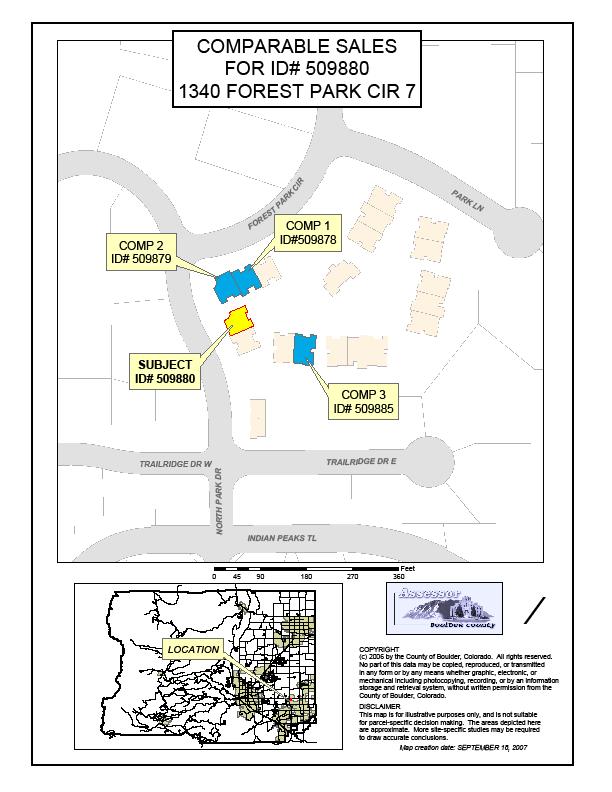
40 Comparable maps

41 Traffic & Golf Course Influences Traffic Golf Course

42 Views & Proximity to Open Views Proximity to Open Space Space Influences

43 Golf Course Golf Course Influence


44 Sales Prices for 14 th & Walnut in 3D Mountain Views RTD Bus Terminal

45 Contact Information Contributing Editors Brooke Cholvin Lori Krager Presenter Rachel Parrinello Mary Sampson Sandy Ingalls Stefanie Schroeder Cindy Braddock, GIS Deputy
Presented by: Stewart Information International, Inc. Jack McKenna
 Presented by: Stewart Information International, Inc. Jack McKenna Held at the: 2007 ESRI Survey & Engineering GIS Summit San Diego Convention Center San Diego, California June 16-19, 2007 Integrating
Land Details. Bridging the Gap between Assessor Acres and GIS Acres
 Land Details Bridging the Gap between Assessor Acres and GIS Acres What are Assessor Acres? It is a legally agreed upon approximation of size Applies to larger parcels Has deep historical roots. Thomas
TROUBLESHOOTING YOUR CAMA DATA WITH GIS
 Chad Rupert Office of Information Technology Outreach Services (ITOS) University of Georgia Athens, GA 30602-5418 Ph: 706-542-5308 Email: rupert@itos.uga.edu Jimmy Nolan Office of Information Technology
New Models for Property Data Verification and Valuation
 New Models for Property Data Verification and Valuation for 2006 IAAO Councils and Sections Joint Seminar May 9-11, 2006 Charleston, South Carolina Presented by George Donatello, CMS Principal Consultant
Using GIS To Manage Surface Ownership and Right-Of-Way
 Using GIS To Manage Surface Ownership and Right-Of-Way Jeff Bute - Sr. Land Maintenance Rep. / GIS Analyst Jeff was formerly a Property Tax Right of Way and Claims field agent for the company. Now he uses
Town of Gilford, New Hampshire
 Town of Gilford, New Hampshire Technical Report: Build-Out Analysis Prepared by: Lakes Region Planning Commission 3 Main Street, Suite 3 Meredith, NH 03253 August 2003 Funding for this report was provided,
2018 Assessment Roll Edit Guide for Parcel-Level Geographical Information System (GIS) Information
 Information") 2018 Assessment Roll Edit Guide for Parcel-Level Geographical Information System (GIS) Information Florida Department of Revenue Property Tax Oversight January 2, 2018 Intended Users This edit guide is
2018 Assessment Roll Edit Guide for Parcel-Level Geographical Information System (GIS) Information Florida Department of Revenue Property Tax Oversight January 2, 2018 Intended Users This edit guide is
Letters of Map Amendment- Out as Shown
 Letters of Map Amendment- Out as Shown While digital Flood Insurance Rate Maps (DFIRM s) have made it easier to determine if a structure (or building site) is in the special flood hazard area (SFHA), many
GOVERNMENT. Case Study Ville de Trois Rivières streamlines property assessment
 GOVERNMENT Case Study Ville de Trois Rivières streamlines property assessment GIS-generated parcel basemap provides powerful visualization & analysis capabilities With a population of just over 130,000,
Integrating SAS and Geographic Information Systems for Regional Land Use Planning
 Integrating SAS and Geographic Information Systems for Regional Land Use Planning ABSTRACT Bill Bass, Houston-Galveston Area Council, Houston, Tx The Houston-Galveston Area Council (H-GAC) provides regional
Town of North Topsail Beach
 Town of North Topsail Beach Build-Out and Non-Conforming Lot Study In Coordination with The Eastern Carolina Council of Governments February 2010 Introduction The Town of North Topsail Beach has conducted
LLANO CENTRAL APPRAISAL DISTRICT REAPPRAISAL PLAN FOR TAX YEARS 2017 & 2018 AS ADOPTED BY THE BOARD OF DIRECTORS
 LLANO CENTRAL APPRAISAL DISTRICT REAPPRAISAL PLAN FOR TAX YEARS 2017 & 2018 AS ADOPTED BY THE BOARD OF DIRECTORS TABLE OF CONTENTS ITEM PAGE Executive Summary 5 Revaluation Decision (Statutory or Administrative)
UNDERSTANDING YOUR PROPERTY RECORD CARD
 UNDERSTANDING YOUR PROPERTY RECORD CARD OBJECTIVE: At first glance, the real estate property assessment record card can be intimidating. There is a wealth of information that can be difficult to read and
City of Surrey s Digital Plan Submission Process
 City of Surrey s Digital Plan Submission Process Cadastral Update Karen Stewart, B.Tech. (GIS) Spatial Information Manager Peter Mueller, B.C.L.S., C.L.S. Survey Manager City of Surrey, British Columbia,
Course Mass Appraisal Practices and Procedures
 Course 331 - Mass Appraisal Practices and Procedures Course Description This course is designed to build on the subject matter covered in Course 300 Fundamentals of Mass Appraisal and prepare the student
CFPB Implementation of Parcels Provision in HMDA Under Dodd-Frank
 CFPB Implementation of Parcels Provision in HMDA Under Dodd-Frank Land ownership is the foundation of the financial, legal, and real estate systems in our society Parcel Data vs. Census Data + Census data
A Geocoded Cadastral Fabric as a Precondition for a Sustainable Land Management System
 A Geocoded Fabric as a Precondition for a Sustainable Land Management System Gottfried KONECNY, Germany; J.P. LAUZON, Canada; Abdul Salam MOHAMMED, India Key words: SDI,, Parcel Boundaries, GPS-GNSS, Land
RESIDENTIAL SALES DATA METHODOLOGY CY2009 (Prepared November 2010)
") A. Source of Data RESIDENTIAL SALES DATA METHODOLOGY CY2009 (Prepared November 2010) The Sales data for calendar year (CY) 2009 are derived from the MdProperty View 1 Sales Databases created for Maryland
A. Source of Data RESIDENTIAL SALES DATA METHODOLOGY CY2009 (Prepared November 2010) The Sales data for calendar year (CY) 2009 are derived from the MdProperty View 1 Sales Databases created for Maryland
Cadastral Framework Standards
 Cadastral Framework Standards The goal of the Data Standards and Recommendations Committee is to provide recommendations and guidelines to Indiana GIS user communities to facilitate the collection, maintenance
A Review and Perspective on Parcel Data Models for Urban Planning
 A Review and Perspective on Parcel Data Models for Urban Planning Yiqiang Ouyang Prof. Dr. Ilir Bejleri Department of Urban and Regional Planning University of Florida June 19-21, 2010 1 Content 1. Introduction
Opening: GIS Specialist and Real Property Lister Department: Land Management
 Opening: GIS Specialist and Real Property Lister Department: Land Management Trempealeau County Human Resource Department 36245 Main St., PO Box 67, Whitehall, WI 54773 715-538-2311 ext 224 personnel@tremplocounty.com
CITY OF JACKSONVILLE, FLORIDA
 PROPERTY APPRAISER DEPARTMENT VISION: To earn the public s trust. DEPARTMENT MISSION: We will: Produce a fair, equitable and accurate tax roll as required by law. Focus on our customers the taxpayers.
Accounts in Brazoria County have two primary Identification numbers. The two forms of Identification are as follows:
 Accounts in Brazoria County have two primary Identification numbers. The two forms of Identification are as follows: Property ID: This is a six digit number that is generated sequentially as accounts are
METHODOLOGY GUIDE VALUING LANDS IN TRANSITION IN ONTARIO. Valuation Date: January 1, 2016
 METHODOLOGY GUIDE VALUING LANDS IN TRANSITION IN ONTARIO Valuation Date: January 1, 2016 August 2017 August 22, 2017 The Municipal Property Assessment Corporation (MPAC) is responsible for accurately assessing
ASSESSOR'S OFFICE I. DEPARTMENT MISSION OR MANDATE OR GOAL
 ASSESSOR'S OFFICE I. DEPARTMENT MISSION OR MANDATE OR GOAL The purpose of the Assessor's Office is to produce a timely roll of all property subject to local assessment; administer legally permissible exemptions;
QUESTIONNAIRE. 1. Authorizing statute(s) citation West Virginia Code and 11-1C-4(d)
 citation West Virginia Code and 11-1C-4(d)") QUESTIONNAIRE (Please include a copy of this form with each filing of your rule: Notice of Public Hearing or Comment Period; Proposed Rule, and if needed, Emergency and Modified Rule.) DATE: 6/8/15 TO:
QUESTIONNAIRE (Please include a copy of this form with each filing of your rule: Notice of Public Hearing or Comment Period; Proposed Rule, and if needed, Emergency and Modified Rule.) DATE: 6/8/15 TO:
ASSESSMENT METHODOLOGY
 2019 ASSESSMENT METHODOLOGY COMMERCIAL RETAIL AND OFFICE CONDOMINIUMS A summary of the methods used by the City of Edmonton in determining the value of commercial retail and office condominium properties
Back to Back and Stacked Townhouses
 Back to Back and Stacked Townhouses Draft Urban Design Guidelines & Proposed Zoning Regulations March 29, 2017 What have we done so far? September 19, 2016 Report to PDC summarizing positive and negative
5. PROPERTY VALUES. In this section, we focus on the economic impact that AMDimpaired
 5. PROPERTY VALUES In this section, we focus on the economic impact that AMDimpaired streams have on residential property prices. AMD lends itself particularly well to property value analysis because its
D DAVID PUBLISHING. Mass Valuation and the Implementation Necessity of GIS (Geographic Information System) in Albania
 in Albania") Journal of Civil Engineering and Architecture 9 (2015) 1506-1512 doi: 10.17265/1934-7359/2015.12.012 D DAVID PUBLISHING Mass Valuation and the Implementation Necessity of GIS (Geographic Elfrida Shehu
Journal of Civil Engineering and Architecture 9 (2015) 1506-1512 doi: 10.17265/1934-7359/2015.12.012 D DAVID PUBLISHING Mass Valuation and the Implementation Necessity of GIS (Geographic Elfrida Shehu
General Instructions For Surveys and Plans Outside the Provincial Survey System
 May 15, 2018 General Instructions For Surveys and Plans Outside the Provincial Survey System NOTE: This document is a Controller of Surveys Policy manual to be used as a general guideline for the Legal
Program Data Table Item 13. Adjusted Special Flood Hazard Area (asfha) GOAL:
 GOAL:") Community Rating System analysis procedure Wednesday, September 15, 2015 Prepared by Laura Gibson, reviewed by Mike Dumais and Beth Yang Program Data Table Item 13. Adjusted Special Flood Hazard Area (asfha)
Community Rating System analysis procedure Wednesday, September 15, 2015 Prepared by Laura Gibson, reviewed by Mike Dumais and Beth Yang Program Data Table Item 13. Adjusted Special Flood Hazard Area (asfha)
DALLAS CENTRAL APPRAISAL DISTRICT DCAD VALUATION PROCESSES
 DALLAS CENTRAL APPRAISAL DISTRICT DCAD VALUATION PROCESSES DALLAS CENTRAL APPRAISAL DISTRICT DCAD DCAD appraisers appraise a large universe of properties by developing appraisal models DCAD appraisers
Return on Investment Model
 THOMAS JEFFERSON PLANNING DISTRICT COMMISSION Return on Investment Model Last Updated 7/11/2013 The Thomas Jefferson Planning District Commission developed a Return on Investment model that calculates
Database Verification for Water Lines Assessment in Banyan Village, Port LaBelle
 Database Verification for Water Lines Assessment in Banyan Village, Port LaBelle March 16, 2010 by Estelle Gagnaire, M.E. Margherita Fanchiotti Intelligentsia International, Inc. and John Capece, Ph.D.
Real Estate PRECISION EXAMS
 PRECISION EXAMS Real Estate EXAM INFORMATION Items 48 Points 50 Prerequisites NONE Grade Level 10-12 Course Length ONE SEMESTER Career Cluster MARKETING DESCRIPTION Students will be introduced to real
RIM Spatial Data. Subhead for title slide
 RIM Spatial Data Subhead for title slide 1. GIS Data & Map Products 2. Spatial Data Accuracy Limitations 3. Application Phase: Map and Shapefile 4. More on Boundary Creation Considerations GIS Data & Map
Cadastral NSDI Reference Document
 Cadastral NSDI Reference Document Version 12 October 2012 FGDC Subcommittee for Cadastral Data Cadastral NSDI Reference Document Table of Contents 1. Purpose... 1 2. Business Applications... 1 3. Terminology
A Vision for a Fully Digital Cadastral Survey System
 A Vision for a Fully Digital Cadastral Survey System Anselm HAANEN, Trent GULLIVER, New Zealand Key words: cadastral survey system, digital cadastre, survey plans SUMMARY Surveyors have traditionally prepared
Fairview Condominiums Apartment Development Opportunity SWC E. 9th Ave. & County Line Rd. 804 Summer Hawk Drive Longmont, Colorado 80405
 Fairview Condominiums Apartment Development Opportunity SWC E. 9th Ave. & County Line Rd. 804 Summer Hawk Drive Longmont, Colorado 80405 Aaron Foy 1225 17th Street Suite 1800 Denver, CO 80202 ph: 303.328.2056
If you want even more information, look for the advanced training, which includes more use cases and demonstrates CU s full functionality.
 Thank you for attending the Collateral Underwriter user interface basic training. My name is Steve Jones and I will be taking you through the course. Our objective today is to provide a foundational understanding
REAL ESTATE MARKET AND YOUR TAX
 REAL ESTATE MARKET AND YOUR TAX ASSESSMENT All of us Island property owners received our tax assessment notices from the County recently. As real estate agents we have been fielding many questions about
BUSI 452 Case Studies in Appraisal II
 BUSI 452 Case Studies in Appraisal II PURPOSE AND SCOPE The Case Studies in Appraisal II course (BUSI 452) is a continuation of BUSI 442. This course is intended to introduce further practical applications
Landbase Accuracy with Cadastral Editor
 Landbase Accuracy with Cadastral Editor City Makes Enhancements for Improved Planning By Kristy M. Capobianco, GISP, RS&H Donald Terrell, GISP, City of Jacksonville Beach and William C. Mann, AICP, City
PLANNING AND ZONING COMMISSION AGENDA MEMORANDUM
 City and County of Broomfield, Colorado PLANNING AND ZONING COMMISSION AGENDA MEMORANDUM To: Planning and Zoning Commission From: John Hilgers, Planning Director Anna Bertanzetti, Principal Planner Meeting
Filing Instructions - Farm Property Appeal Form
 Filing Instructions - Farm Property Appeal Form A. Read attached guidelines for detailed instructions. B. Read & complete PTAX-227 Form Tazewell County Board of Review Guidelines Rule 1 Appeals The Township
Demonstrate knowledge of, and extract, cadastral data from Landonline
 Page 1 of 5 Demonstrate knowledge of, and extract, cadastral data from Landonline Level 3 Credits 5 Purpose This unit standard is for people who are working in the surveying industry in jobs which involve
EXPLAINING MASS APPRAISAL
 EXPLAINING MASS APPRAISAL PROMOTING THE ROLE OF THE ASSESSOR MAAO SUMMER CONFERENCE, JUNE 24, 2015 RICHARD W. FINNEGAN, MAA Please excuse the length of this letter. I didn t have time to write a short
APPLICATION OF GEOGRAPHIC INFORMATION SYSTEM IN PROPERTY VALUATION. University of Nairobi
 APPLICATION OF GEOGRAPHIC INFORMATION SYSTEM IN PROPERTY VALUATION Thesis Presented by STEPHEN WAKABA GATHERU F56/69748/2013 Supervised by DR. DAVID NYIKA School of Engineering Department of Geospatial
EduMapping + JobMapping
 EduMapping + JobMapping Frans Rip Centre for Geoinformation, Wageningen UR 18 April 2011 1. What is EduMapping? Present GI-course descriptions Toekomst: mèt etiket Assessment by teacher Course content
Property Appraisal Division Finance Department Anchorage: Performance. Value. Results.
 Anchorage: Performance. Value. Results. Mission Provide a fair and equitable basis for taxation in the Municipality of Anchorage in conformance with State law and professional standards. Core Services
The Newsletter of the Maine Chapter IAAO SPRING Covering Maine Assessing FROM THE EDITOR:
 Covering Maine Assessing The Newsletter of the Maine Chapter IAAO SPRING 2013 FROM THE EDITOR: Maine chapter iaao SPRING 2013 By Kyle Avila, CMA I use GIS daily for explaining valuations to taxpayers in
Hennepin County Economic Analysis Executive Summary
 Hennepin County Economic Analysis Executive Summary Embrace Open Space commissioned an economic study of home values in Hennepin County to quantify the financial impact of proximity to open spaces on the
Questions and Answers For Recorders About Land Records And GIS Integration
 2501 Aerial Center Parkway, Suite 103, Morrisville, NC 27560 877.997.7742 Questions and Answers For Recorders About Land Records And GIS Integration Adopted by the PRIA Board on March 15, 2011 http://www.pria.us
MEDIA RELEASE. For Immediate Release June 28, 2010: (408)
") County of Santa Clara Office of the County Assessor County Government Center, East Wing 70 West Hedding Street San Jose, California 95110-1770 1-408-299-5500 FAX 1-408-297-9526 E-Mail: david.ginsborg@asr.sccgov.org
County of Santa Clara Office of the County Assessor County Government Center, East Wing 70 West Hedding Street San Jose, California 95110-1770 1-408-299-5500 FAX 1-408-297-9526 E-Mail: david.ginsborg@asr.sccgov.org
Cadastral PLSS Stewardship December 2010 Updated December 2013
 Cadastral PLSS Stewardship December 2010 Updated December 2013 Compiled by Bob Ader, Ben Knott, and Nancy von Meyer for the FGDC Cadastral Subcommittee Table of Contents 1. Overview... 2 2. Underlying
Installation Boundary Mapping and the DoD Real Property Inventory Program
 Installation Boundary Mapping and the DoD Real Property Inventory Program 11 October 2007 SAME Mid-Atlantic Regional Conference Jeff Swallow Real Property History Real Property data reported to the Office
Filing Instructions - Residential Property Appeal Form
 Filing Instructions - Residential Property Appeal Form A. Read attached guidelines for detailed instructions. B. Read & complete PTAX-230 Form C. To prove value, you may: 1. submit an appraisal. 2. submit
2009 QBS Request for Statement of Interest (SOI) On Call Appraisal Services
 On Call Appraisal Services") 2009 QBS Request for Statement of Interest (SOI) On Call Appraisal Services The Kane County Division of Transportation is in need of professional services from an appraisal firm to provide appraisals for
2009 QBS Request for Statement of Interest (SOI) On Call Appraisal Services The Kane County Division of Transportation is in need of professional services from an appraisal firm to provide appraisals for
ERER Pilot Measurements County & Trusted Submitter
 ERER Pilot Measurements County & Trusted Submitter ERER Task Force Consideration 1. Cost / Benefit - Consider studying existing system configurations, hardware types, outsourcing practices, and vendor
Office of the City Auditor. Audit of the Office of the Real Estate Assessor
 Report Date: August 28, 2015 Office of the City Auditor 2401 Courthouse Drive, Room 344 Virginia Beach, Virginia 23456 757.385.5870 Promoting Accountability and Integrity in City Operations Contact Information
Flood Hazard Modelling
 Flood Hazard Modelling Identification Information Dataset Name: Rapid Flood Hazard Model, Detailed Flood Hazard Model Dataset Abstract: The flood hazard model identifies areas that may be subject to flooding
An Evaluative Approach for Creating Digital Torrens Abstract Boundaries: A Case Study for Hennepin County, MN
 An Evaluative Approach for Creating Digital Torrens Abstract Boundaries: A Case Study for Hennepin County, MN Andrew King-Scribbins Saint Mary s University of Minnesota, Department of Resource Analysis,
Table of Contents SECTION 1. Overview... ix. Schedule...xiii. Part 1. Origins of Eminent Domain
 Table of Contents Overview... ix Schedule...xiii SECTION 1 Part 1. Origins of Eminent Domain Preview Part 1... 1 Origins of Eminent Domain... 3 Definitions... 4 Sources of Eminent Domain Law... 6 Agencies
Initial sales ratio to determine the current overall level of value. Number of sales vacant and improved, by neighborhood.
 Introduction The International Association of Assessing Officers (IAAO) defines the market approach: In its broadest use, it might denote any valuation procedure intended to produce an estimate of market
METHODOLOGY GUIDE VALUING OFFICE BUILDINGS IN ONTARIO. Valuation Date: January 1, 2016
 METHODOLOGY GUIDE VALUING OFFICE BUILDINGS IN ONTARIO Valuation Date: January 1, 2016 AUGUST 2016 August 22, 2016 The Municipal Property Assessment Corporation (MPAC) is responsible for accurately assessing
(Chapter 277, Laws of 2018; SSB 6175)
") MAP AND SURVEY PREPARATION GUIDELINES FOR CONDOMINIUMS, COOPERATIVES AND MISCELLANEOUS COMMUNITIES CREATED UNDER WASHINGTON UNIFORM COMMON INTEREST OWNERSHIP ACT WUCIOA (CH. 64.90 RCW) (Chapter 277, Laws
MAP AND SURVEY PREPARATION GUIDELINES FOR CONDOMINIUMS, COOPERATIVES AND MISCELLANEOUS COMMUNITIES CREATED UNDER WASHINGTON UNIFORM COMMON INTEREST OWNERSHIP ACT WUCIOA (CH. 64.90 RCW) (Chapter 277, Laws
Pecos County Appraisal District. Chief Appraiser: Sam Calderon III
 Pecos County Appraisal District Chief Appraiser: Sam Calderon III Meet Your Appraiser Staff Agenda The goals and objectives of this presentation is to provide Property Owner s an overview of PCAD s Appraisal
Appraisal Engagement Instructions
 Appraisal Engagement Instructions OVERVIEW The appraisal report must be prepared by a state licensed or certified appraiser and must comply with the Appraiser Independence Requirements (AIR), Uniform Standards
Re-sales Analyses - Lansink and MPAC
 Appendix G Re-sales Analyses - Lansink and MPAC Introduction Lansink Appraisal and Consulting released case studies on the impact of proximity to industrial wind turbines (IWTs) on sale prices for properties
Table of Contents SECTION 1. Overview... ix. Schedule...xiii. Part 1. Origins of Eminent Domain
 Table of Contents Overview... ix Schedule...xiii SECTION 1 Part 1. Origins of Eminent Domain Preview Part 1... 1 Origins of Eminent Domain... 3 Definitions... 4 Sources of Eminent Domain Law... 5 Agencies
The Strategic Plan can be viewed by clicking this link.
 What is the purpose of the Land Information Office? Many of Brown County's most basic services rely on accurate and up-to-date land information. Emergency response, resource conservation, infrastructure
TRAVIS CENTRAL APPRAISAL DISTRICT REAPPRAISAL PLAN FOR TAX YEARS
 TRAVIS CENTRAL APPRAISAL DISTRICT REAPPRAISAL PLAN FOR TAX YEARS 2017-2018 ADOPTED: August 29, 2016 Table of Contents Table of Contents... 2 Notice... 4 Executive Summary... 5 Texas Property Tax Code Requirements...
Uniform Appraisal Dataset (UAD) Frequently Asked Questions
 Frequently Asked Questions") Uniform Appraisal Dataset (UAD) Frequently Asked Questions July 13, 2014 Updated for formatting May 15, 2017 The following provides answers to questions frequently asked about Fannie Mae s and Freddie
Uniform Appraisal Dataset (UAD) Frequently Asked Questions July 13, 2014 Updated for formatting May 15, 2017 The following provides answers to questions frequently asked about Fannie Mae s and Freddie
ASSESSMENT METHODOLOGY
 2018 ASSESSMENT METHODOLOGY COST APPROACH A summary of the methods used by the City of Edmonton in determining the value of residential and non-residential properties valued using the cost approach in
Delivering the 2016 Assessment Update
 Delivering the 2016 Assessment Update Municipality of Port Hope Public Information Meeting May 18, 2016 Catherine Barr - Account Manager and Bert Moline Manager Valuations & Customer Relation PROPERTY
Reporting Thailand Cadastral System in Cadastre 2014 Trends BY VUTTINAN UTESNAN. Rajamangala University of Technology Krungthep
 Reporting Thailand Cadastral System in Cadastre 2014 Trends BY VUTTINAN UTESNAN Rajamangala University of Technology Krungthep Faculty of Engineering, Bangkok, THAILAND Topics INTRODUCTION THAILAND CADASTRAL
Underwriting the FHA Appraisal
 Disclosure The purpose of this presentation is an overview of the subject matter with summation and explanation of recent changes in FHA policy. It introduces and explains, rather than supplants, official
Will County GIS Product Distribution Policy January, 2008
 Will County GIS Product Distribution Policy January, 2008 Background: The goal of this policy is to provide GIS products to users in a reasonable manner and to ensure that products released are of sufficient
Customer Classifications and Allocation Policies
 City of San Juan Capistrano Customer Classifications and Allocation Policies Effective July 1, 2014 Overview: How the City Calculates Monthly Allocations Residential Lot Size and House Size For all single
Streetscape Character Manual 1
 Streetscape Character Manual A Streetscape Character Analysis is a scoped Neighbourhood Character Statement & Compatibility Report for Low-Rise Residential Infill & Intensification How to use this manual:
Table of Contents. Page 2 of 11 CRMLS Rules & Regulations Reference Guide Effective
 Table of Contents I. Rules Enforcement... 3 II. Accuracy of Information... 3 III. Late Entry of Listings... 4 IV. Listing Status Changes... 5 V. Listing Images & Virtual Tour Information... 6 VI. Public
New Developments in the Hellenic Cadastre
 New Developments in the Hellenic Cadastre Prof. M. Kavouras Vice-president Ktimatologio S.A. (Hellenic Cadastre) The Hellenic Cadastre Background The Hellenic National Cadastre Organizational and institutional
Revised Tax Map Rules
 Revised Tax Map Rules PVC Subcommittee Committee Report October 3, 2013 Prepared by: Kurt Donaldson Manager WV GIS Technical Center West Virginia University Phone: (304) 293-9467 kdonalds@wvu.edu Contents
Cadastral NSDI Reference Document July 2006
 Cadastral NSDI Reference Document July 2006 Purpose This document describes the Cadastral NSDI, its components and the public and private business processes that define the content. The Cadastral National
A project of Neighborhood Projects for Community Revitalization At the Center for Urban and Regional Affairs (CURA) University of Minnesota
 University of Minnesota") Affordable Housing Siting Opportunities in Minneapolis October 2008 Rachel C. Robinson, Author With assistance from Joel Larson A project of Neighborhood Projects for Community Revitalization At the Center
Affordable Housing Siting Opportunities in Minneapolis October 2008 Rachel C. Robinson, Author With assistance from Joel Larson A project of Neighborhood Projects for Community Revitalization At the Center
RAINS COUNTY APPRAISAL DISTRICT
 RAINS COUNTY APPRAISAL DISTRICT 2017 MASS APPRAISAL SUMMARY REPORT mass appraisal report 2017 uspap_appr_report RAINS COUNTY APPRAISAL DISTRICT 2017 MASS APPRAISAL SUMMARY REPORT Identification of Subject:
Mobile and Tablet. Ready
 Realtors are demanding newer and more accurate solutions to assist them in client communications. These solutions need to be able to deliver accurate property information both in and outside the office.
Assessor. Mission Statement: Functions: Long Term Goals: Page 1 of 6
 Assessor Mission Statement: The mission of the Assessor s Office is to create accurate, equitable, and timely property tax assessments to fund public services; and to be a source of current, accurate property
TREASURER S DEPARTMENT
 TREASURER S DEPARTMENT ORGANIZATIONAL CHART COUNTY TREASURER ADMINISTRATION SERVICE TO PUBLIC SERVICE TO COUNTY DEPARTMENTS SERVICE TO COUNTY GOV T DEPARTMENT DESCRIPTION The Treasurer s Office is a mandated
REDSTONE. Regression Fundamentals.
 REDSTONE from Bradford Advanced Analytics Technologies for Appraisers Regression Fundamentals www.bradfordsoftware.com/redstone Bradford Technologies, Inc. 302 Piercy Road San Jose, CA 95138 800-622-8727
A CADASTRAL GEODATA BASE FOR LAND ADMINISTRATION USING ARCGIS CADASTRAL FABRIC MODEL A CASE STUDY OF UWANI ENUGU, ENUGU STATE, NIGERIA
 A CADASTRAL GEODATA BASE FOR LAND ADMINISTRATION USING ARCGIS CADASTRAL FABRIC MODEL A CASE STUDY OF UWANI ENUGU, ENUGU STATE, NIGERIA BY Ndukwu, Raphael. Ike Department of Geoinformatics & Surveying University
2015 ROUTT COUNTY BOARD OF EQUALIZATION Hearing Date: July 28 th, 2015
 205 ROUTT COUNTY BOARD OF EQUALIZATION Hearing Date: July 28 th, 205 Account#: R87255, R872553, R872556, R872559 PIN#: 28900003, 28900005, 28900008, 289000 Owner of Record: ADAMO FAMILY PARTNERSHIP, FAIR
Comprehensive Plan 2015 to 2030 STATE OF LAND USE
 Chapter 2 Land Use The responsibility of a municipality to manage and regulate land use is rooted in its need to protect the health, safety, and welfare of local citizens. Although only acting as one section
Collateral Underwriter Overview. National Association of REALTORS January 23, 2015
 Collateral Underwriter Overview National Association of REALTORS January 23, 2015 2014 Fannie Mae. Trademarks of Fannie Mae. Introduction to Collateral Underwriter I January 2015 What Is Collateral Underwriter?
Cadastral Template 2003
 PCGIAP-Working Group 3 "Cadastre" FIG-Commission 7 "Cadastre and Land Management" Cadastral Template 2003 The establishment of a cadastral template is one of the objectives of Working Group 3 "Cadastre"
1. A portion of the cost to the public body for obtaining the original or copies of the documents, printouts or photographs.
 39-121.03. Request for copies, printouts or photographs; statement of purpose; commercial purpose as abuse of public record; determination by governor; civil penalty; definition A. When a person requests
2. Is the information in the contract section complete and accurate? Yes No Not Applicable If Yes, provide a brief summary.
 The purpose of this appraisal field review report is to provide the lender/client with an opinion on the accuracy of the appraisal report under review. Property Address City State Zip Code Borrower Owner
Appraisal Review Reminders
 Use the following list of reminders as a tool when underwriting the appraisal report. For complete information on appraisal requirements, refer to the Freddie Mac Seller/Servicer Guide (Guide) Chapter
Demonstration Properties for the TAUREAN Residential Valuation System
 Demonstration Properties for the TAUREAN Residential Valuation System Taurean has provided a set of four sample subject properties to demonstrate many of the valuation system s features and capabilities.