Sahmakum Teang Tnaut June 2012
|
|
|
- Felicity Evans
- 5 years ago
- Views:
Transcription
1

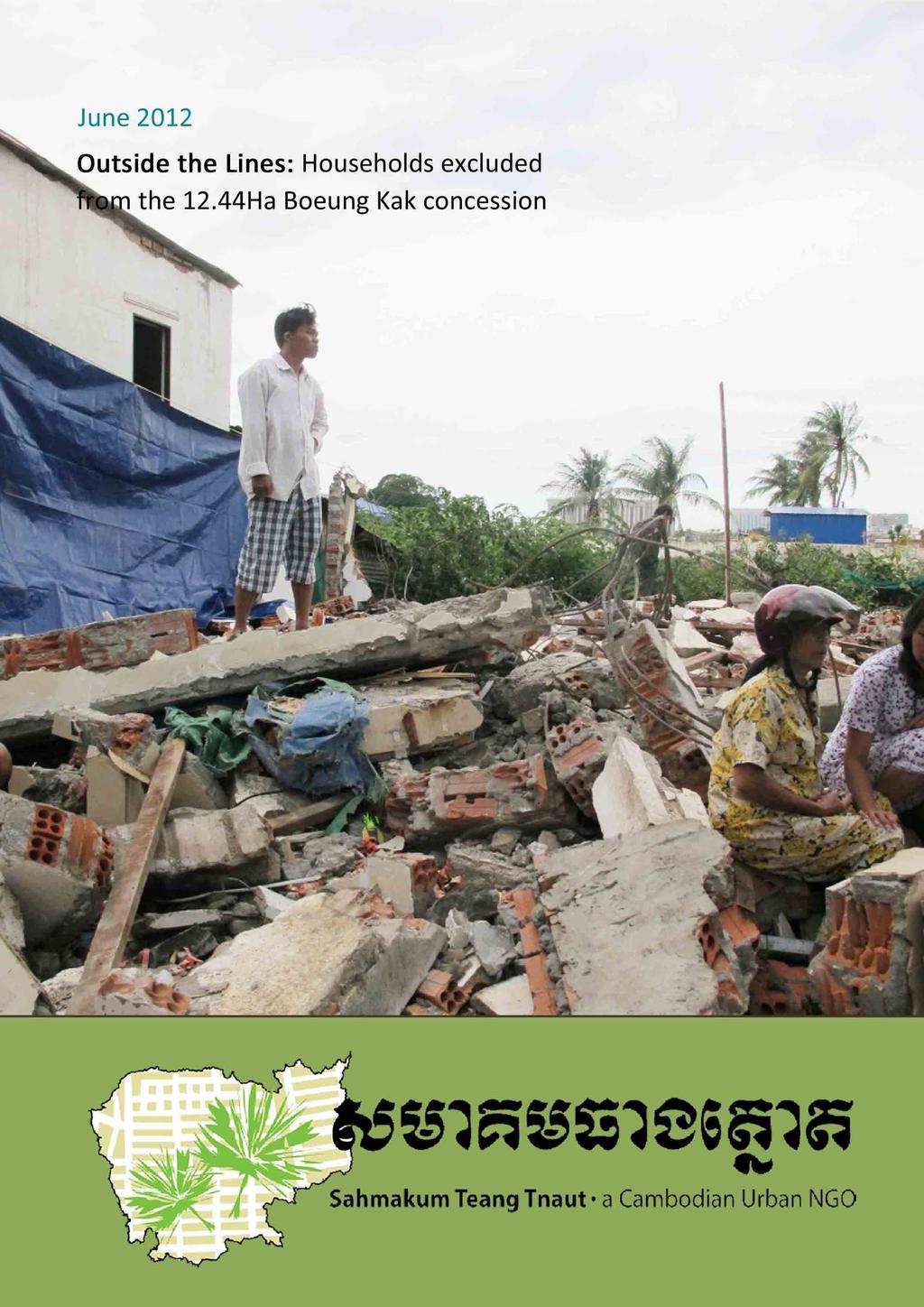
2 Sahmakum Teang Tnaut June 2012 Author: Wilfred Waters and Ket Mengcheang Editor: Nora Lindstrom Researchers: Ket Mengcheang, Tim Sreyleak, Say Chhay, Chum Makara With special thanks to the Boeung Kak community
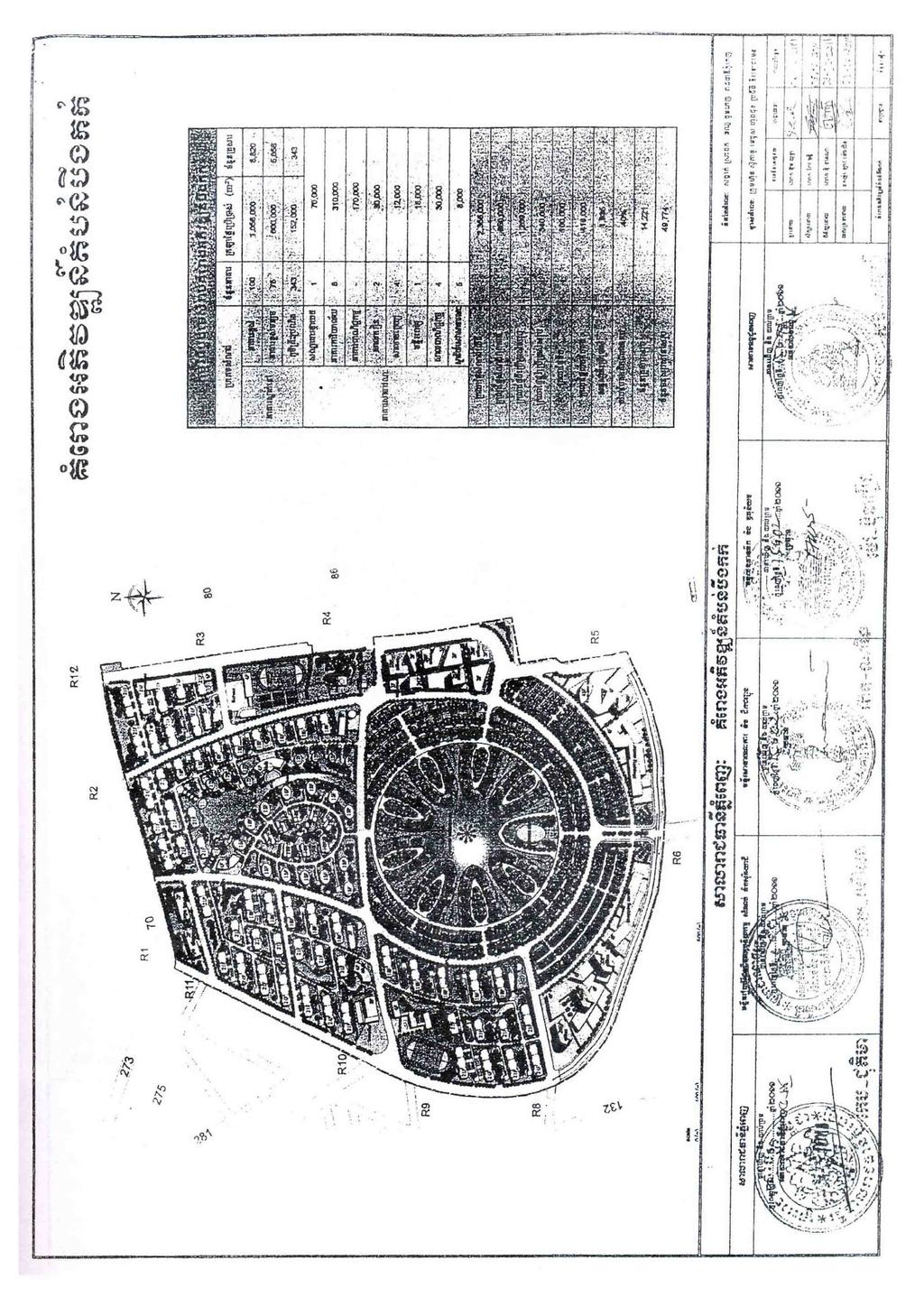
3 Outside the Lines: Households Excluded from the 12.44Ha Boeung Kak concession (STT 2012) Introduction On Aug , Prime Minister Hun Sen signed Sub-Decree No. 183, awarding 12.44Ha of the Boeung Kak lake area to the community. This marked a major victory for remaining households in the community, who had been fighting for their land since 2007, when 133Ha of the natural lake were leased for 99-years to Shukaku Inc., owned by CPP senator Lao Meng Khin, under dubious circumstances. Yet the victory was bittersweet. Some 85% of the community, representing over 3,500 households, had already been forcibly displaced from the area. In addition, not all homes of those remaining in the area were included in the 12.44Ha concession, while rumours abounded that plots within the concession had been awarded to Lao Meng Khin. At the request of the Boeung Kak community, STT in early 2012 undertook to map the boundaries of the 12.44Ha concession together with any empty plots within that area, as well as the location of households seemingly excluded from the concession. Methodology In , STT produced a dataset of house footprints around Boeung Kak. This project involved a field survey, using a handheld GPS (10m circular error) to obtain the locations of all houses in the area, after which footprints were digitised around each point using a Geoeye satellite image (0.6m resolution). Between March May 2012, another field survey identified which of these footprints were now either vacant plots or empty buildings. The project also involved using a GPS to locate a number of new footprints because the dataset was incomplete. These were then digitised using a 2011 Geoeye image (0.5m resolution). In order to obtain the locations of the households excluded from the 12.44Ha area, STT conducted field visits guided by community members and used a handheld GPS to confirm locations. It should be noted, however, that because STT relied on community cooperation in identifying excluded households, excluded households in the area who do not work with community representatives may have been omitted in this survey. The boundaries of the 12.44ha concession were obtained from Sub-Decree no Definition of a vacant plot For the purposes of this survey, the majority of house footprints can be interpreted as plots of land, as this is a densely settled area where most houses make up the majority of a plot of land. Due to this, we refer to footprints where houses have been torn down as vacant plots. Where a house is surrounded by a significantly larger (generally walled) plot of land, we have drawn this on the map to indicate that this space is not available for others to live on. Accuracy Given the GPS error, the positions of building footprints on the map are likely to be ±10m. Due to the image resolutions, the dimensions of them are ±0.5m at best. In practice, however, they are approximately ±2m due to digitising by hand rather than obtaining measurements with high accuracy surveying equipment, and due to georeferencing errors. 1
 As indicated on the map, there was a small area in the upper half of the northern section which could not be reached and an area in the lower half of the")
4 Outside the Lines: Households Excluded from the 12.44Ha Boeung Kak concession (STT 2012) As indicated on the map, there was a small area in the upper half of the northern section which could not be reached and an area in the lower half of the southern section where boundaries of larger plots of land were unclear. Hence there may be extra vacant plots not detected by this survey. Regarding the excluded households, a number are now covered by sand, such that locations indicated by villagers may have been approximate. Overall, information on the map is meant to be indicative, showing, for example, the presence of a vacant plot, rather than its precise dimensions or location. In particular, the map is not meant to show definite exclusion of households from the 12.44Ha concession. Houses in Village 1 being covered in sand (October 2010) Results This land use survey reveals that most of the 12.44Ha concession is occupied by houses, with locations where houses have been demolished (defined as vacant plots) taking up the next largest proportion of the concession (see Table 1). In total, 5.11Ha, or around 41%, of the land in the concession area is visibly occupied. An additional 17% of the land, equivalent to 401 plots, in the concession was previously occupied, but has become vacant as a result of the previous owners accepting compensation, demolishing their homes, and leaving the area. The remaining land in the concession area is taken up by abandoned buildings (1.5%), unoccupied plots with unclear ownership claims (1%), as well as roads, footpaths and other spaces unaccounted for in this survey due to limitations to access and/or uncertain boundaries (39%). 2
5 Outside the Lines: Households Excluded from the 12.44Ha Boeung Kak concession (STT 2012) Table 1. Type of plot by area and amount within 12.44ha concession. Percentage of Type of plot Amount Percentage of total number of plots Area covered (ha) 12.44Ha concession Occupied house % a % Walled plot of land % 1.30 b 10.43% containing occupied house Vacant plot % % Abandoned building % % Unoccupied plot of % % land (unclear ownership claims) Total % % Note. a. Numbers in this document are rounded to two decimal places, but all calculations are based on non-rounded numbers. b. Area of occupied houses that are contained by plots of land has been subtracted from the area of the plot of land. The area of the vacant plots identified within the 12.44Ha concession amounts to 2.12Ha. The northern section of the concession has a greater proportion of vacant plots, these being concentrated in the centre. Most vacant plots in the southern section are in the lower half. Occupied houses are concentrated around the outside of the northern section and in the upper part of the southern section. No empty buildings in the southern section were identified, these being gathered in the lower half of the northern section. A total of 70 households were identified as excluded from the concession. Of these, 52 homes continue to be occupied, while 18 (most of which are in Village 1) are covered by sand. Conclusion These results indicate that households excluded from the 12.44Ha concession could be given a vacant plot within it, from the perspective of land availability. For example, providing each of the 70 excluded households a small 4x16m plot within the concession would require a total area of 0.45Ha. This represents 21% of the area (2.12Ha) identified as vacated by previous occupants, or 3.6% of the 12.44Ha concession. Adding this 0.45Ha to the area of land already classified as visibly occupied houses and plots of land (5.11Ha) would mean that the occupied proportion of the 12.44Ha concession would increase to 45%. To illustrate how the excluded households could be included in the concession, an arbitrary group of 70 of the currently vacant plots are shaded in on the map. Note however that the selected plots are equal to or smaller than 4x16m and that this does not represent a claim to a particular area of land. An alternative way of solving the issue for some of the households excluded from the 12.44Ha concession, is to change the boundary of the concession. Households located on the Western edge of the concession in Villages 6, 22, and 24 could easily be incorporated into the concession area by increasing its size by 0.90Ha, for a total concession area of 13.34Ha. The proposed change in the concession boundary is illustrated on the map. 3

6
7
8

9
10

11
Boeung Kok Alternative Planning. January 2011
 Boeung Kok Alternative Planning. January 2011 Boeung Kok Development plan Masterplan of the Boung Kok development and the surrounding. Source : Bureau des Affaires urbaines, Municipalité de Phnom Penh
A Geocoded Cadastral Fabric as a Precondition for a Sustainable Land Management System
 A Geocoded Fabric as a Precondition for a Sustainable Land Management System Gottfried KONECNY, Germany; J.P. LAUZON, Canada; Abdul Salam MOHAMMED, India Key words: SDI,, Parcel Boundaries, GPS-GNSS, Land
The Effects of Housing Price Changes on the Distribution of Housing Wealth in Singapore
 The Effects of Housing Price Changes on the Distribution of Housing Wealth in Singapore Joy Chan Yuen Yee & Liu Yunhua Nanyang Business School, Nanyang Technological University, Nanyang Avenue, Singapore
Prices of dwellings in housing companies
 Housing 2017 Prices of dwellings in housing companies 2017, November Prices of dwellings in housing companies fell in November According to Statistics Finland s preliminary data, prices of dwellings in
Prices of dwellings in housing companies
 Housing 2017 Prices of dwellings in housing companies 2017, October Prices of dwellings in housing companies fell in October According to Statistics Finland s preliminary data, prices of dwellings in old
Prices of dwellings in housing companies
 Housing 2017 Prices of dwellings in housing companies 2017, July Prices of units in housing companies rose in July According to Statistics Finland s preliminary data, prices of dwellings in old blocks
Prices of dwellings. Prices of dwellings rose in May. 2012, May
 Housing 2012 Prices of dwellings 2012, May Prices of dwellings rose in May According to Statistics Finland s preliminary data, prices of old dwellings in blocks of flats and terraced houses went up by
A mix of uses. Housing:
 7 Massing and uses Page 79 7:1. A mix of uses % Total Habitable Occ/ People Rooms HR Studio 6.8% 308 1 0.90 277 1 bed 32.0% 1442 2 0.90 2,595 2 bed 37.6% 1691 3 0.90 4,567 3 bed 21.2% 955 4 0.90 3,438
Prices of dwellings in housing companies
 Housing 2017 Prices of dwellings in housing companies 2017, September and 3rd quarter Prices of old dwellings in housing companies rose slightly in the third quarter According to Statistics Finland's preliminary
Homeowners Guide to Accessory Dwelling Units
 Homeowners Guide to Accessory Dwelling Units Applicable to Buildings in existence AFTER July 14, 1994 In accordance with Zoning By law 2010 050 and the Ontario Building Code 2012 Town of Bradford West
By: Barney I. S. Laseko Programme Coordinator Prime Minister s Office TANZANIA
 2014 CONFERENCE ON LAND POLICY IN AFRICA 11 14 NOVEMBER, 2014 Focussed Discussion VIII Converting from Manual Land Registration to GIS Enabled Land Information System Case of Sub Saharan Africa Tanzania
Key findings from an investigation into low- and medium-value property sales. National Audit Office September 2017 DP
 from an investigation into low- and medium-value property sales National Audit Office September 207 DP 557-00 from an investigation into low- and medium-value property sales Contents 3 4 5 6 7 8 9 0 2
Existing Land Use. Typical densities for single-family detached residential development in Cumberland County: 1
 Existing Land Use A description of existing land use in Cumberland County is fundamental to understanding the character of the County and its development related issues. Economic factors, development trends,
City Center Market-Rate Housing Study
 City Center Market-Rate Housing Study OVERVIEW The City of Bellingham, with the assistance of students from Western Washington University, conducted a study of market-rate rental housing during April and
Briefing Book. State of the Housing Market Update San Francisco Mayor s Office of Housing and Community Development
 Briefing Book State of the Housing Market Update 2014 San Francisco Mayor s Office of Housing and Community Development August 2014 Table of Contents Project Background 2 Household Income Background and
RESIDUAL ANALYSIS PRINCIPLES AND PROCEEDURES
 RESIDUAL ANALYSIS PRINCIPLES AND PROCEEDURES OVERVIEW 1. Residual analysis or extractions, are a form of land valuation study. 2. This analysis relies on the improved sales (typically the largest group
Expropriation. Recommended Policy Wordings (full): Lao National Land Policy. Context. Policy. Standard of Public Purpose
: Lao National Land Policy. Context. Policy. Standard of Public Purpose") Expropriation Context Following from the goal of the National Land Policy, to promote and ensure a secure land tenure system that is transparent, effective, non-discriminative, equitable and just ; it
Expropriation Context Following from the goal of the National Land Policy, to promote and ensure a secure land tenure system that is transparent, effective, non-discriminative, equitable and just ; it
Housing affordability in England and Wales: 2018
 Statistical bulletin Housing affordability in England and Wales: 2018 Brings together data on house prices and annual earnings to calculate affordability ratios for national and subnational geographies
Following is an example of an income and expense benchmark worksheet:
 After analyzing income and expense information and establishing typical rents and expenses, apply benchmarks and base standards to the reappraisal area. Following is an example of an income and expense
acuitas, inc. s survey of fair value audit deficiencies August 31, 2014 pcaob inspections methodology description of a deficiency
 August 31, 2014 home executive summary audit deficiencies improve pcaob inspections methodology description of a deficiency audit deficiency trends fvm deficiencies description of fair value measurement
MARION COUNTY, FLORIDA AMENDED AND RESTATED INITIAL ASSESSMENT RESOLUTION
 MARION COUNTY, FLORIDA AMENDED AND RESTATED INITIAL ASSESSMENT RESOLUTION ADOPTED JULY 7, 2015 TABLE OF CONTENTS Page SECTION 1. AUTHORITY... 1 SECTION 2. PURPOSE AND DEFINITIONS... 1 SECTION 3. CONFIRMATION
Quality Improvement to Cadastral Information in Sweden
 Gunnar BLIXT, Sweden Key words: digital cadastre, quality, cadastral index map, real property register. SUMMARY Lantmäteriet is a governmental agency which gives support for creating an efficient and sustainable
Country-Specific Legislation and Practice. Greece
 Country-Specific Legislation and Practice Country Chapter Greece Introduction One of the guiding principles of TEGoVA is to promote consistency of standard definitions of value and approaches to valuation
Rents of Dwellings 2017
 Housing 2018 Rents of Dwellings 2017 Rents increased by 1.5 per cent over the year Rents of residential dwellings increased by an average of 1.5 per cent in 2017 from the year before. Rents of non-subsidised
NEVEREND FARM BARNS NEVEREND FARM, PYE CORNER, ULCOMBE, KENT ME17 1EF
 NEVEREND FARM BARNS NEVEREND FARM, PYE CORNER, ULCOMBE, KENT ME17 1EF Artists Impression South Elevation www.btfpartnership.co.uk Land & Property Experts NEVEREND FARM BARNS NEVEREND FARM PYE CORNER ULCOMBE
Roding Lane North. Woodford IG8 8ND FREEHOLD RESIDENTIAL DEVELOPMENT SITE WITH PLANNING PERMISSION FOR 28 HOUSES ON THE OUTSKIRTS OF WOODFORD
 FREEHOLD RESIDENTIAL DEVELOPMENT SITE WITH PLANNING PERMISSION FOR 28 HOUSES ON THE OUTSKIRTS OF WOODFORD Summary Summary Located on, Location Surrounded by fields to the south and Clayland Woods and Clayland
Kingdom of Cambodia Nation Religion King
 Royal Government of Cambodia No. 39. ANKr.BK Kingdom of Cambodia Nation Religion King Sub-Decree on Management of Borey Royal Government - Having seen the Constitution of the Kingdom of Cambodia; - Having
A5 A3 RIVER THAMES A2 A6 STEWART STREET SITE PLAN SUNSET. Plans not to scale SUNRISE
 FLOOR PLANS PHASE 1 1 A3 RIVER THAMES STEWART STREET SITE PLAN 2 WELCOME HOME 3 Views from river facing apartments only Computer Generated Image River Thames 4 TYPE: ARA 1 BEDROOM BLOCK Plot 23 Level
2015 Downtown Parking Study
 2015 Downtown Parking Study City of Linden Genesee County, Michigan November 2015 Prepared by: City of Linden Downtown Development Authority 132 E. Broad Street Linden, MI 48451 www.lindenmi.us Table of
Census Tract Data Analysis
 Data Analysis Study Area: s within the City of Evansville, Indiana Prepared For Mr. Kelley Coures City of Evansville Department of Metropolitan Development 1 NW MLK Jr. Boulevard Evansville, Indiana 47708
Technical Report 7.1 MODEL REPORT AND PARKING SCENARIOS. May 2016 PARKING MATTERS. Savannah GA Parking Concepts PARKING MATTERS
 Savannah GA Parking Concepts PARKING MATTERS A Strategic Plan for Parking + Mobility in Savannah PARKING MATTERS Technical Report 7.1 MODEL REPORT AND PARKING SCENARIOS Prepared for the Chatham County-Savannah
Performance of the Private Rental Market in Northern Ireland
 Summary Research Report July - December Performance of the Private Rental Market in Northern Ireland Research Report July - December 1 Northern Ireland Rental Index: Issue No. 8 Disclaimer This report
What Every New Zealander Should Know About Relationship Property
 What Every New Zealander Should Know About Relationship Property ARE YOU IN A RELATIONSHIP COVERED BY THE LAW OF RELATIONSHIP PROPERTY? The Property (Relationships) Act 1976 affects the lives of almost
Waterford City and County Council Vacant Homes Action Plan 2017
 Waterford City and County Council Vacant Homes Action Plan 2017 1. Introduction The high demand for residential properties on the property market, slow rate of new build and deepening housing crisis across
Rent Stabilization, Vacancy Decontrol and Reinvestment in Rental Property in Berkeley, California
 Rent Stabilization, Vacancy Decontrol and Reinvestment in Rental Property in Berkeley, California REVISED FINAL REPORT July 16, 2012 Jay Kelekian, Executive Director Stephen Barton, Ph.D., Project Manager
Land Titling in Cambodia: Formalizing Inequality By Natalie Bugalski and David Pred
 Land Titling in Cambodia: Formalizing Inequality By Natalie Bugalski and David Pred In February 2007, the Municipality of Phnom Penh granted a 99-year lease to a private company, Shukaku Inc., over 133
Toronto Preservation Board Toronto East York Community Council. Acting Director, Urban Design, City Planning Division
 STAFF REPORT ACTION REQUIRED Demolition of a Designated Heritage Property within the Yorkville Hazelton Heritage Conservation District and Construction of a Replacement Structure - 129 Hazelton Avenue
2015 ROUTT COUNTY BOARD OF EQUALIZATION Hearing Date: July 28 th, 2015
 205 ROUTT COUNTY BOARD OF EQUALIZATION Hearing Date: July 28 th, 205 Account#: R87255, R872553, R872556, R872559 PIN#: 28900003, 28900005, 28900008, 289000 Owner of Record: ADAMO FAMILY PARTNERSHIP, FAIR
Final Report Taxpayer Complaint. Teller County
 Final Report 2013 Taxpayer Complaint Teller County February 12, 2014 Submitted by: Laura Forbes, Administrative Resources 2013 Taxpayer Complaint Teller County Page 1 Complaint filed: Teller County Property
Landbase Accuracy with Cadastral Editor
 Landbase Accuracy with Cadastral Editor City Makes Enhancements for Improved Planning By Kristy M. Capobianco, GISP, RS&H Donald Terrell, GISP, City of Jacksonville Beach and William C. Mann, AICP, City
concepts and techniques
 concepts and techniques S a m p l e Timed Outline Topic Area DAY 1 Reference(s) Learning Objective The student will learn Teaching Method Time Segment (Minutes) Chapter 1: Introduction to Sales Comparison
ELBOYA HEIGHTS Community Association
 The Elboya/Park Hill Caveat - The Details Background The City of Calgary was the original planner and developer of a portion of the Elboya and Park Hill Community which was previously known as the Stanley
Land Use Survey Summer 2014
 Land Use Survey Summer 2014 North Ogden City, Utah Robert Scott, City Planner Travis Lund, Planning Intern Contents General Information... 1 Land Use Groups... 1 Urbanized Land Uses... 1 Residential...
Plats and subdivisions; mapping requirements. (a) Size Requirements. All land plats presented to the register of deeds for recording in the
 Size Requirements. All land plats presented to the register of deeds for recording in the") 47-30. Plats and subdivisions; mapping requirements. (a) Size Requirements. All land plats presented to the register of deeds for recording in the registry of a county in North Carolina after September
47-30. Plats and subdivisions; mapping requirements. (a) Size Requirements. All land plats presented to the register of deeds for recording in the registry of a county in North Carolina after September
Sales Ratio: Alternative Calculation Methods
 For Discussion: Summary of proposals to amend State Board of Equalization sales ratio calculations June 3, 2010 One of the primary purposes of the sales ratio study is to measure how well assessors track
2.2 Future Demand Projection Methodology
 SECTION 2 Water Demands Water demands were developed for existing and future conditions based on parcel-level land use information and water meter billing data. CH2M HILL worked extensively with Town of
Establishment of a land market in Ukraine: current state and prospects
 Establishment of a land market in Ukraine: current state and prospects More than 25 years have passed since the adoption of the first resolution of the Verkhovna Rada On Land Reform. Despite such a long
CIRCULAR On strategic environmental assessment, environmental impact assessment, and environmental protection plans (*)
") Issue nos 09-10/June 2015 OFFICIAL GAZETTE 17 THE MINISTRY OF NATURAL RESOURCES AND ENVIRONMENT THE SOCIALIST REPUBLIC OF VIETNAM Independence - Freedom - Happiness No. 27/2015/TT-BTNMT Hanoi, May 29,
Issue nos 09-10/June 2015 OFFICIAL GAZETTE 17 THE MINISTRY OF NATURAL RESOURCES AND ENVIRONMENT THE SOCIALIST REPUBLIC OF VIETNAM Independence - Freedom - Happiness No. 27/2015/TT-BTNMT Hanoi, May 29,
Cadastral Survey in the 21 st Century. Gavin Adlington. Land Program Team Leader Europe and Central Asia Region (ECA)
") E-learning Series Cadastral Survey in the 21 st Century June 3, 2010 Gavin Adlington. Land Program Team Leader Europe and Central Asia Region (ECA) The World Bank Content : Purpose of cadastral survey
E-learning Series Cadastral Survey in the 21 st Century June 3, 2010 Gavin Adlington. Land Program Team Leader Europe and Central Asia Region (ECA) The World Bank Content : Purpose of cadastral survey
I 1-1. Staff Comment Form. Heritage Impact Assessment 7764 Churchville Road (Robert Hall House)
") I 1-1 Staff Comment Form Date: March 25, 2013 To: The Brampton Heritage Board Property: Applicant: Daniel Colucci and Larysa Kasij Brampton Heritage Board Date: April 16, 2013 Subject: Heritage Impact
I 1-1 Staff Comment Form Date: March 25, 2013 To: The Brampton Heritage Board Property: Applicant: Daniel Colucci and Larysa Kasij Brampton Heritage Board Date: April 16, 2013 Subject: Heritage Impact
Comparative Housing Market Analysis: Minnetonka and Surrounding Communities
 Comparative Housing Market Analysis: Minnetonka and Surrounding Communities Prepared by Mark Huonder, Eric King, Katie Knoblauch, and Xiaoxu Tang Students in HSG 5464: Understanding Housing Assessment
PREPARING SURVEY TENDER GIS DATABASE OUTCOMES
 PREPARING SURVEY TENDER SPECIFICATIONS FOR PROJECT GIS DATABASE OUTCOMES Presentation by Ian Harper GEODATA AUSTRALIA ESRI User Conference 2009 24 st July 2009 BACKGROUND GIS databases now provide a more
Division: Methodology and Evaluation
 Household-based Sample Design Division: Methodology and Evaluation Mr Muthetho Nkwinika 09 June 2008 UNWTO Capacity Building 1 Household Survey Sampling Process Flow UNWTO Capacity Building 2 Population
RESOLUTION NO ( R)
") RESOLUTION NO. 2013-06- 088 ( R) A RESOLUTION OF THE CITY COUNCIL OF THE CITY OF McKINNEY, TEXAS, APPROVING THE LAND USE ASSUMPTIONS FOR THE 2012-2013 ROADWAY IMPACT FEE UPDATE WHEREAS, per Texas Local
RESOLUTION NO. 2013-06- 088 ( R) A RESOLUTION OF THE CITY COUNCIL OF THE CITY OF McKINNEY, TEXAS, APPROVING THE LAND USE ASSUMPTIONS FOR THE 2012-2013 ROADWAY IMPACT FEE UPDATE WHEREAS, per Texas Local
Methodology for the Production and Updating of Agricultural Land Use/Cover Data Set
 Methodology for the Production and Updating of Agricultural Land Use/Cover Data Set Halil Ibrahim INAN & Ismail DURSUN Erciyes University, Faculty of Engineering, Department of Geomatics Engineering http://harita.erciyes.edu.tr
IFRS - 3. Business Combinations. By:
 IFRS - 3 Business Combinations Objective 1. The purpose of this IFRS is to specify to disclose financial information by an entity when carrying out a business combination. In particular, specifies that
Alternatives for Economic Boundary Determination in the Establishment of a Cadastral System. Paper to the FIG Working Week 2012 Rome, May 9, 2012
 Alternatives for Economic Boundary Determination in the Establishment of a Cadastral System Paper to the FIG Working Week 2012 Rome, May 9, 2012 by Gottfried Konecny Emeritus Professor Leibniz University
INDIAN INSTITUTE OF TECHNOLOGY ROORKEE. Presentation on REAL TIME CADASTRAL SURVEYING SOLUTION WITH A SPECIAL IMPHESIS TO MODERN GPS TECHNOLOGY.
 INDIAN INSTITUTE OF TECHNOLOGY ROORKEE Presentation on REAL TIME CADASTRAL SURVEYING SOLUTION WITH A SPECIAL IMPHESIS TO MODERN GPS TECHNOLOGY By: Prof. Kamal Jain, Dept. of Civil Engg. IIT-Roorkee AIM
Vista Village Apartments
 Vista Village Apartments Property Report 1125 N 7th St Sierra Vista, AZ 85635 Vista Village Apartments CONTENTS 01 Executive Summary Executive Summary 3 Unit Mix Summary 4 Location Summary 5 04 Sale Comps
STATE LAND AUDIT REPORT
 STATE LAND AUDIT REPORT 1 Presentation to the Portfolio Committee on Rural Development and Land Reform M514 Marks Building 30 March 2011 CHIEF SURVEYOR GENERAL Mr M RIBA Content 2 Background Project Objectives
Table of Contents. Appendix...22
 Table Contents 1. Background 3 1.1 Purpose.3 1.2 Data Sources 3 1.3 Data Aggregation...4 1.4 Principles Methodology.. 5 2. Existing Population, Dwelling Units and Employment 6 2.1 Population.6 2.1.1 Distribution
Manhattan Rental Market Report Year End 2009
 Manhattan Rental Market Report Year End 2009 Table of Contents Introduction 3 A Quick Look 4 Mean Manhattan Rental Prices 5 Notable Trends 7 Manhattan Price Trends 7 Neighborhood Price Trends Upper West
The cost of increasing social and affordable housing supply in New South Wales
 The cost of increasing social and affordable housing supply in New South Wales Prepared for Shelter NSW Date December 2014 Prepared by Emilio Ferrer 0412 2512 701 eferrer@sphere.com.au 1 Contents 1 Background
A5 A3 RIVER THAMES A2 A6 STEWART STREET SITE PLAN SUNSET. Plans not to scale SUNRISE
 FLOOR PLANS 1 RIVER THAMES STEWART STREET SITE PLAN WELCOME HOME 4 TYPE: ARA 1 BEDROOM BLOCK Plot 23 Level 1 Plot 25 Level 2 Plot 29 Level 3 Living / Kitchen / Dining * *Please note window omitted to
Affordable Housing in the Draft National Planning Policy Framework
 Affordable Housing in the Draft National Planning Policy Framework Introduction 1. The draft National Planning Policy Framework (NPPF) proposes to cancel Planning Policy Statement 3 (PPS3) Housing (2005
Implementation of Fit for Purpose Land Administration in Nepal, in a post disaster context.
 Implementation of Fit for Purpose Land Administration in Nepal, in a post disaster context. Paula Dijkstra, Raja Ram Chhatkuli, Danilo Antonio, Eva-Maria Unger, Chrit Lemmen Wondimagegm Tesfaye, Shristee
Zoning Analysis. 2.0 Residential Use. 1.0 Introduction
 Zoning Analysis 1.0 Introduction For zoning to be an effective community development tool, it must recognize the unique land use characteristics of the various portions of the community. The Lawrence Zoning
WHO OWNS THE A CRITIQUE OF THE STATE LAND AUDIT
 WHO OWNS THE A CRITIQUE OF THE STATE LAND AUDIT March 2018 Published by the South African Institute of Race Relations (IRR) 2 Clamart Road, Richmond Johannesburg, 2092 South Africa P O Box 291722, Melville,
The COMPLETE GUIDE To Privately Selling Or Renting Your Own Property
 The COMPLETE GUIDE To Privately Selling Or Renting Your Own Property Preparing Your Property for Sale or Rent By preparing your property correctly for your target market, you will be assured that you have
Valuation Methodology of Unregistered Properties in East Africa
 FIG KL 2014 Valuation Methodology of Unregistered Properties in East Africa James Kavanagh MRICS John Tracey-White FRICS Valuation Methodology of Unregistered Properties in East Africa Origin of the Study
Sub-Degree on the Procedure of Establishing. Cadastral Index Map and Land Register
 The Royal Government of Cambodia N o 11 ANK.BK/ March 22, 2000 Sub-Degree on the Procedure of Establishing Cadastral Index Map and Land Register - Having seen the Constitution of the Kingdom of Cambodia
Figure 2: Detail of the new front entrance porch. Image courtesy of the Arlington County Historic Preservation Program.
 Figure 1: Current front view of the Washington/Torreyson Farm House, from North Lexington Street looking south. Figure 2: Detail of the new front entrance porch. Figure 3: Front view of the Washington/Torreyson
Northern Branch Corridor DEIS December Appendix D: Local Tax Base
 Appendix D: Local Tax Base D. LOCAL TAX BASE D.1 Existing Conditions The local tax base is under the jurisdiction of each municipality. Assessed value of property varies based on a number of factors,
CONSTRUCTION CONTRACTS OF FLAT FOR LAND BASIS WİTHİN THE SCOPE OF URBAN TRANSFORMATİON PROJECT
 0 CONSTRUCTION CONTRACTS OF FLAT FOR LAND BASIS WİTHİN THE SCOPE OF URBAN TRANSFORMATİON PROJECT Nowadays, the development of the construction industry, urban transformation debates and zoning issues brings
Smoothed Weighted National Housing Index (base = January 2008)
") HOUSING INDEX January 2014 Rising Volumes Decelerate House Prices For Now 220 200 180 160 1 120 100 80 60 Smoothed Weighted National Housing Index (base = January 2008) Value Index Volume Index Although
HOUSING INDEX January 2014 Rising Volumes Decelerate House Prices For Now 220 200 180 160 1 120 100 80 60 Smoothed Weighted National Housing Index (base = January 2008) Value Index Volume Index Although
How to Read Survey Maps
 How to Read Survey Maps Understanding and use of survey and township maps in genealogy (Thanks to the Special Collections and University Archives, Wichita State University Libraries for providing the deck
Village of Cayuga Heights Planning Board Meeting #81 Monday, July 23, 2018 Marcham Hall 7:00 pm Minutes
 Village of Cayuga Heights Planning Board Meeting #81 Monday, July 23, 2018 Marcham Hall 7:00 pm Minutes Present: Planning Board Members Chair F. Cowett, G. Gillespie, J. Leijonhufvud, R. Segelken Code
THE TREND OF REAL ESTATE TAXATION IN KANSAS, 1910 TO 1942¹
 THE TREND OF REAL ESTATE TAXATION IN KANSAS, 1910 TO 1942¹ HAROLD HOWE². INTRODUCTION The purpose of this study is to show the trends of taxes on farm and city real estate in Kansas from 1910 to 1942 and
Suggestion on Annual Refund Ratio of Defect Repairing Deposit in Apartment Building through Defect Lawsuit Case Study
 Suggestion on Annual Refund Ratio of Defect Repairing Deposit in Apartment Building through Defect Lawsuit Case Study Deokseok Seo and Junmo Park Abstract The defect lawsuits over the apartment have not
STATE OF CALIFORNIA AUTHENTICATED ELECTRONIC LEGAL MATERIAL. State of California GOVERNMENT CODE. Section 65915
 STATE OF CALIFORNIA AUTHENTICATED ELECTRONIC LEGAL MATERIAL State of California GOVERNMENT CODE Section 65915 65915. (a) When an applicant seeks a density bonus for a housing development within, or for
Note on housing supply policies in draft London Plan Dec 2017 note by Duncan Bowie who agrees to it being published by Just Space
 Note on housing supply policies in draft London Plan Dec 2017 note by Duncan Bowie who agrees to it being published by Just Space 1 Housing density and sustainable residential quality. The draft has amended
A Guide to Vancouver s Empty Homes Tax Last updated: July 4, 2017
 A Guide to Vancouver s Empty Homes Tax Last updated: July 4, 2017 Vancouver s new Empty Homes Tax (EHT) became effective January 1, 2017, as per the Vacancy Tax Bylaw No. 11674 (By-law). The EHT targets
ARLA Members Survey of the Private Rented Sector
 Prepared for The Association of Residential Letting Agents ARLA Members Survey of the Private Rented Sector Second Quarter 2014 Prepared by: O M Carey Jones 5 Henshaw Lane Yeadon Leeds LS19 7RW June, 2014
SUPREME COURT OF PRINCE EDWARD ISLAND KEL-MAC INCORPORATED. Before: The Honourable Justice Benjamin B. Taylor
 SUPREME COURT OF PRINCE EDWARD ISLAND Citation: Kel-Mac v. Town of Stratford 2009 PESC 04 Date: 20090226 Docket: S1-GS-22841 Registry: Charlottetown BETWEEN: KEL-MAC INCORPORATED APPLICANT AND: TOWN OF
Land at Hydepark Road Hydepark Lane, Mallusk Newtownabbey BT36 4QD
 FOR SALE 9024 8181 OKT.CO.UK On the instructions of Tom Keenan & Scott Murray of Keenan CF as Joint Administrators of McCloskey & O Kane Building Company Ltd FOR IDENTIFICATION PUROSES ONLY Land at Hydepark
Housing Supply Overview
 Housing Supply Overview A RESEARCH TOOL PROVIDED BY SOUTH CAROLINA REALTORS October 2018 Although every community is different, a general analysis of all housing markets across the country reveals that
The Impact of Market Rate Vacancy Increases Eleven-Year Report
 The Impact of Market Rate Vacancy Increases Eleven-Year Report January 1, 1999 - December 31, 2009 Santa Monica Rent Control Board April 2010 TABLE OF CONTENTS Summary 1 Vacancy Decontrol s Effects on
Hi-tech Survey Operation using Modern Technologies: Concept & Process Flow
 Hi-tech Survey Operation using Modern Technologies: Concept & Process Flow Presented by Sri Biswaranjan Rath Asst. Director,CLR Board of Revenue, Odisha Limitations of present system of surveying Survey
Generic Environmental Impact Statement. Build-Out Analysis. City of Buffalo, New York. Prepared by:
 Generic Environmental Impact Statement Build-Out Analysis City of Buffalo, New York 2015 Prepared by: TABLE OF CONTENTS 1.0 INTRODUCTION 1 2.0 METHODOLOGY 2 3.0 EXISTING LAND USE 3 4.0 EXISTING ZONING
REFORM OF LAND CADASTRE IN LITHUANIA
 REFORM OF LAND CADASTRE IN LITHUANIA Romualdas KASPERAVICIUS, Lithuania Key words: ABSTRACT Main aim for every Government is to create legal, financial and organisational circumstances for real property.
COMMUNICATION URBAN DESIGN REVIEW BOARD CITY OF DES MOINES, IOWA NOVEMBER 1, 2016, 2016 MEETING
 COMMUNICATION URBAN DESIGN REVIEW BOARD CITY OF DES MOINES, IOWA NOVEMBER 1, 2016, 2016 MEETING Subject: Recommendation Prepared by: PRELIMINARY DESIGN AND FINANCIAL REVIEW 401 SE 6 TH STREET- CONNOLLY
The Fit- for-purpose Concept
 The Fit- for-purpose Concept Building Spatial Frameworks for Sustainable Land Governance in Sub-Sahara Africa Prof. Stig Enemark Honorary President Aalborg University, Denmark LAND POLICIES AND LAND GOVERNANCE,
The Housing and Planning Bill and related issues.
 Briefing 16/04 February 2016 The Housing and Planning Bill 2015-16 and related issues. To: All English contacts For info: Contacts from Wales, Scotland and Northern Ireland. Key issues Government attempts
BUSI 330 Suggested Answers to Review and Discussion Questions: Lesson 9
 BUSI 330 Suggested Answers to Review and Discussion Questions: Lesson 9 1. Students should give a brief definition of each of the following terms and provide one example which illustrates how they are
City Plan Sub- Committee Report
 AGENDA ITEM: Date: 21 st July 2016 City Plan Sub- Committee Report Classification: Title: Report of: Cabinet Member Portfolio: Wards Affected: City for All Key Decision: Financial Summary: Report Author
STANDARDS OF PRACTICE
 STANDARDS OF PRACTICE Association of Nova Scotia Land Surveyors Approved by the membership on the 15 th day of October, 2015 (Effective January 1, 2016; Revised October 14, 2016) Page 1 of 18 STANDARDS
Residential Density Bonus
 Chapter 27 Residential Density Bonus 27.010 Purpose and Intent This chapter is intended to provide incentives for the production of housing for Very Low, Lower Income, Moderate or Senior Housing in accordance
Buyout Area in Wayne, NJ. Photo by author. Wayne, New Jersey
 Buyout Area in Wayne, NJ. Photo by author Wayne, New Jersey Background Wayne is a mid-sized township of just under 55,000 inhabitants located in Passaic County, in northern New Jersey (see Figure 1). The
Chapter 9 Multiple Choice Questions
 Chapter 9 Multiple Choice Questions / Page 1 Chapter 9 Multiple Choice Questions 1. The text argues that students of real estate should study factors that influence demand at the national, regional, community
Memo to the Planning Commission JULY 12TH, 2018
 Memo to the Planning Commission JULY 12TH, 2018 Topic: California State Senate Bill 828 and State Assembly Bill 1771 Staff Contacts: Joshua Switzky, Land Use & Housing Program Manager, Citywide Division