Hungarian practice of servicing cadastral information Piroska Zalaba senior counselor
|
|
|
- Ashlie Miller
- 6 years ago
- Views:
Transcription

1 Hungarian practice of servicing cadastral information Piroska Zalaba senior counselor Ministry of Agriculture and Rural Development Department of Land Administration and Geoinformation Cadastre, Public Policies and Economic Activity, Spanish Presidency of PCC, Madrid, Spain, 1-2 June 2010
2 Land management sector has a multi-purpose role under the authority of DLAG MoA Land Management Sector: overall responsibility land administration: registration (all land parcels, real estates, incl. condominiums), land valuation, use and protection, land lease registration large scale cadastral and topographic mapping geodesy, land surveying unified land registry and cadastre infrastructure development: Land Information Systems complex land management
3 since 1972 Best practice of Hungary Unified Land Registry = Cadastre multipurpose including condominiums unified both organizationally and technically comprehensive approach of land and property matters avoiding data inconsistency complex services providing reliable basic data for specific purposes obligatory usage of cadastral/land registry data
4 Structure of the land management sector Ministry of Agriculture and Rural Development Department of Land Administration and Geoinformation County Land Offices 19 offices District Land Offices 118 offices Capital Land Office 1 office Capital District Land Office 3 offices Institute of Geodesy Cartography and Remote Sensing (FÖMI) Total staff over 4100 persons Annual budget approx million EURE (from 2007 absolutely self-financing financing institutional background, functioning is covered from the income of services and procedures) IT infrastructure follows this structure
5 Legal issues Law on Surveying and Mapping (passed in 1996) Law on Land Registration (1997) - based on electronic data processing - executive decree came into force in 1999 Act on Arable Land (1994) Law on Land Mortgage Institution (1997) Ministerial Decree about the public usage of the land office network (2002), modification (2004)
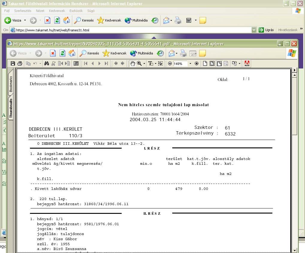
6 Main services - also electronically Copy of property sheet - paper-based, authentic - electronic document (e-authetic, non-authentic) Copy of map extract - paper-based, authenticated - electronic document (non-authentic) Copy of land lease sheet - paper-based, authentic - electronic document (e-authetic from February 2010) Watch Dog Service Change monitoring system Sending short information about the changes of data of selected property sheets via or/and SMS e.g. new application, new note important for the banks in mortgage activities
7 2009/ január 2008/ október Number of users of land office e-services Number of users of land office e-services increasing number of TakarNet certificates 2008/ július 2008/ április 2008/ január 2007/ október 2007/ július 2007/ április 2007/ január 2006/ október 2006/ július 2006/ április 2006/ január 2005/ október 2005/ július 2005/ április 2005/ január 2004/ október 2004/ július 2004/ április 2004/ január 2003/ október 2003/ július 2003/ április 10,000 9,000 8,000 7,000 6,000 5,000 4,000 3,000 2,000 1,000 0
8 Number of property sheet copies requested electronically Property sheet copies requested via TAKARNET per year (April 2003 January 2009)
9 The change in servicing property sheet copies Since starting the TakarNet services the composition of property sheet copies: Paper-based TAKARNET Altogether % 10% % 22% % 28% % 46% % 58% % 68% * 31% of the copies serviced by land offices are free of charge * 70% of the copies provided via TakarNet are free of charge
10 Number of copy of map extract requests Number of copy of map extract requests Number of TAKARNET map requests monthly June, September, pieces in all

11 TAKARNET services for external users
12

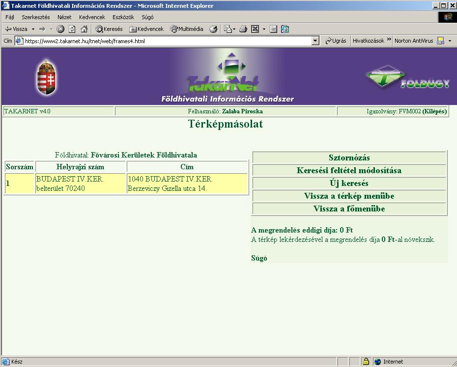
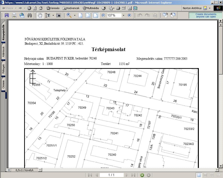
13 Copy of a map extract

14 Land Office Customer Services in shopping centres Special TAKARNET application - Better customer satisfaction: Budapest: Lurdy-Ház Székesfehérvár: Auchan
15 New development concept: Digital Land Office First step: TakarNet24 project Main goals: Creating central database for the electronic services Providing non-stop services Making available the land office data via governmental portal, Clients Gate Digital payment possibilities Establishing infrastructure for electronic land office application management Interoperability with other databases, instituions, eg. local governments, personal data and and address database etc.

16 Land Office Portal

17
e-land Administration in Hungary
 e-land Administration in Hungary Piroska Zalaba senior counsellor, project manager Ministry of Agriculture and Rural Development Department of Lands and Mapping FIG SEMINAR Innsbruck, 2-4 June 2004 Land
DATR towards e-land Administration in Hungary
 DATR towards e-land Administration in Hungary Gyula IVÁN-Gábor SZABÓ-Zoltán WENINGER-Piroska Zalaba Institute of Geodesy, Cartography and Remote Sensing, Budapest, HUNGARY XXIV. FIG Congress Facing the
EVOLUTION TOWARDS THE DIGITAL LAND OFFICES
 EVOLUTION TOWARDS THE DIGITAL LAND OFFICES Szabolcs MIHÁLY, Piroska ZALABA Budapest, Hungary 1. INTRODUCTION 2. CURRENT STATUS OF THE UNIFORM LAND REGISTRATION 2.1. Management Features of the Hungarian
The Multipurpose Hungarian Unified Land Registry System
 The Multipurpose Hungarian Unified Land Registry System András Osskó FIG Working Week Integrating Generation Stockholm, Sweden 14-19 June 2008 Republic of Hungary is located in Central Europe Neighbouring
Unified Land Administration for a Better Spatial Infrastructure
 Unified Land Administration for a Better Spatial Infrastructure Gyula IVÁN Institute of Geodesy, Cartography & Remote Sensing FÖMI (HUNGARY) Open Symposium 30th Korean Cadastral Seminar & FIG Commission
Country report, HUNGARY
 Country report, HUNGARY Gyula IVÁN Institute of Geodesy, Cartography & Remote Sensing (FÖMI) HUNGARY FIG Commission 7 Annual Meeting 2009 12-16 October, 2009, Kuala Lumpur, Malaysia Institute of Geodesy,
Hungary is a landlocked, Central European country in the Carpathian Basin
 Brief Overview on Hungarian Land Administration MSc. György Domokos Hungarian Geodetic Surveying Liaison Group CLGE GA Hannover 12 13 October 2012 Hungary is a landlocked, Central European country in the
Test and Implementation of DATR System in Hungary
 Test and Implementation of DATR System in Hungary, Hungary Key words: unified land registry, cadastral map, Hungary SUMMARY During the last years there has been an important development in the Hungarian
TAKARNET intranet for the land administration
 Paper presented at the FIG Commission 3 Annual Meeting and Seminar Budapest, Hungary, 1999 TAKARNET intranet for the land administration Piroska Zalaba Ministry of Agriculture and Regional Development
DATR Towards e-land Administration in Hungary
 DATR Towards e-land Administration in Hungary Gyula IVÁN, Gábor SZABÓ, Zoltán WENINGER, Piroska ZALABA, HUNGARY Key words: Land Registry, Cadastre, Land Administration, GIS SUMMARY DATR has been the most
Improvement of Effectiveness Present Developments in Hungarian Land Administration
 Improvement of Effectiveness Present Developments in Hungarian Land Administration Gyula IVÁN and András OSSKÓ, Hungary Key words: Land Administration, Cadastre, Land Registry SUMMARY New Act on Surveying
Object Oriented Unified Real Estate Registry for a Good Spatial Data Management
 Object Oriented Unified Real Estate Registry for a Good Spatial Data Management Gyula IVÁN Gábor SZABÓ Zoltán WENINGER Institute of Geodesy, Cartography and Remote Sensing (FÖMI), Hungary Workshop on e-governance,
A Complete, Free Solution for Cadastral Map Management
 A Complete, Free Solution for Cadastral Map Management Gyula IVÁN Institute of Geodesy, Cartography & Remote Sensing (FÖMI) HUNGARY FIG Commission 7, Annual Meeting 11-15 September 2008., Verona, ITALY
New Danish e-cadastre and its role in the Danish e-government
 New Danish e-cadastre and its role in the Danish e-government PCC Budapest 2011 Pia Dahl Højgaard, pdh@kms.dk Cadastre and Legal Authority, National Survey and Mapping, Denmark The danish context Neighbours
Expansion of Land Information Services in Hungarian Land Administration
 Expansion of Land Information Services in Hungarian Land Administration Gyula IVÁN, Gábor SZABÓ and Zoltán WENINGER, Hungary Key words: Land registry, Cadastral system, GIS, LIS, WEB based services SUMMARY
Integrated Land Information Services in Hungarian Land Administration
 , Hungary Key words: key words, theme, etc. SUMMARY The Unified Hungarian Land Registry, in which cadastral mapping and land registry belong to the same organization (Land Office Network), has been operating
ABSTRACT Land Administration System in Lithuania
 ABSTRACT Land Administration System in Lithuania 1. General introduction to the Lithuanian Land Administration System and State Enterprise Centre of Registers ( shortly SECR) Lithuania has established
Public and State Land Management in Hungary
 Public and State Land Management in Hungary ANDRÁS OSSKÓ WORKING WEEK 2012 May 6-10 2012 ROME, ITALY CONTENT 1. Introduction 2. Legal and institutional background 3. Activities of the national land fund
The importance of changes in land surveyors education
 András OSSKÓ Key words: land administration, roles of land surveyors, extended education, lifelong learning SUMMARY It s a world wide experience, especially in developed countries that the interest in
INSPIRED Property. Ownership, Planning, Protection and the People
 INSPIRED Property Ownership, Planning, Protection and the People Robin Waters, Royal Institution of Chartered Surveyors, UK Robin McLaren, Know Edge, UK Piroska Zalaba, Ministry of Rural Development, Hungary
Cadastre and Land Registration in Europe
 Annex A: Questionnaire 2007 for Information Resource Cadastre and Land Registration in Europe Introduction This questionnaire is based on the EuroGeographics vision document 'Cadastre and Land Registration
BULGARIAN CADASTRE A GUARANTEE FOR THE OWNERSHIP RIGHTS IN IMMOVABLE PROPERTIES
 4 TH INTERNATIONAL CONFERENCE RECENT PROBLEMS IN GEODESY AND RELATED FIELDS WITH INTERNATIONAL IMPORTANCE February 28 - March 2, 2007, Inter Expo Centre, Sofia, Bulgaria BULGARIAN CADASTRE A GUARANTEE
Hungarian Cadastre and its relation to LADM
 Hungarian Cadastre and its relation to LADM Gyula IVÁN CLGE General Assembly 22 March 2013, Budapest, HUNGARY Content Historical background Evolution of Cadastral modeling in Hungary LADM issues Conclusion
STATE COMMITTEE OF THE REPUBLIC OF UZBEKISTAN ON LAND RESOURCES, GEODESIES, TO CARTOGRAPHY AND STATE INVENTORY
 STATE COMMITTEE OF THE REPUBLIC OF UZBEKISTAN ON LAND RESOURCES, GEODESIES, TO CARTOGRAPHY AND STATE INVENTORY Development of services in providing information on land resources and real estate, introduction
Towards 3D Land Registry in Hungary
 Towards 3D Land Registry in Hungary Gyula IVÁN, András OSSKÓ, Hungary Keywords: Cadastre, Land Administration, Land Registry, 3D Cadastre, GIS SUMMARY New Act on Surveying and Mapping Activities, accepted
Support of Disaster Management by Land Administration and SDI
 Support of Disaster Management by Land Administration and SDI Key words: Spatial Data Infrastructure, Land Administration, GIS, Disaster Management SUMMARY Institute of Geodesy, Cartography and Remote
Development of 3D Cadastre in Hungary
 Development of 3D Cadastre in Hungary András OSSKÓ Gyula IVÁN CLGE General Assembly 22 March 2013, Budapest, HUNGARY Content Introduction Problems in development of 3D cadastre and registration Hungarian
Land Registers Interconnection Gabriel Sima European Commission, DG Justice and Consumers
 Land Registers Interconnection Gabriel Sima European Commission, DG Justice and Consumers Contents Context LRI Project status System implementation National establishments for land registration Electronic
The Development of the Austrian Cadastre from Documentation to an Integrated Planning and Decision Support System
 The Development of the Austrian Cadastre from Documentation to an Integrated Planning and Decision Support System WPLA - Working Party on Land Administration 15-17 October 2014, Vienna, Austria Wernher
Land Administration in Jordan
 Land Administration in Jordan Problems and Challenges Eng. Director of Registration Services Department of Lands & Survey q General information q Historical Background q Properties Initiation q Problems
Object Oriented Unified Real Estate Registry for a Good Spatial Data Management
 Object Oriented Unified Real Estate Registry for a Good Spatial Data Management Gyula IVÁN Gábor SZABÓ Zoltán WENINGER, Hungary Key words: Cadastre, Land Administration, GIS SUMMARY The IT developments
Surveying in Austria. Congress Maanmittauspäivät Seinäjoki, 20 th March 2014
 Surveying in Austria Congress Maanmittauspäivät Seinäjoki, 20 th March 2014 Topics Facts, figures Organisational issues of surveying Role of the BEV Products, services The Cadastre Surveying Education
Republic of Bulgaria
 Geodesy, Cartography and Cadastre Agency Republic of Bulgaria www.cadastre.bg 24. 01. 2018 г., гр. София The Cadastre Legislation in Bulgaria - historical reference 1908 г. The Cadastre Act The objective
THE USE OF THE SPANISH CADASTRE FOR THE CONTROL AND MONITORING OF EU-CAP SUBSIDIES
 WPLA WORKSHOP Budapest THE USE OF THE SPANISH CADASTRE FOR THE CONTROL AND MONITORING OF EU-CAP SUBSIDIES INTRODUCTION The distribution of EU Agricultural Policy (CAP) subsidies has recently undergone
Use of data in Ukraine for sustainable economic growth. Oleksandr Maliuk State Service of Ukraine for Geodesy, Cartography and Cadastre
 Use of data in Ukraine for sustainable economic growth Oleksandr Maliuk State Service of Ukraine for Geodesy, Cartography and Cadastre Kehl, 2017 Content of the presentation Ukraine & StateGeoCadastre:
Results of Central European Land Knowledge Center (CELK) Activities
 Activities") Results of Central European Land Knowledge Center (CELK) Activities András OSSKÓ, Hungary Key words :CELK Center, Property Rights and Land Market Development, Networking, direct knowledge transfer SUMMARY
Results of Central European Land Knowledge Center (CELK) Activities András OSSKÓ, Hungary Key words :CELK Center, Property Rights and Land Market Development, Networking, direct knowledge transfer SUMMARY
Cadastre: definitions
 Introduction New vision towards a multipurpose cadastral system to support land management in Morocco Moha EL-AYACHI, El Hassane SEMLALI, Mohamed ETTARID, Driss TAHIRI, Institut Agronomique et Vétérinaire
Department of Lands and Survey
 Cadastral System in Jordan Department of Lands and Survey Eng. Nedal Al-Sagarat/ Director General Eng. Mouen Sayegh/ IT Manager November, 2011 General Information Historical Background Main Duties Organizational
National Spatial Data Infrastructure development in Republic of Macedonia
 National Spatial Data Infrastructure development in Republic of Macedonia Sonja Dimova, state advisor for geomatics AGENCY FOR REAL ESTATE CADASTRE September 6-th, 2017, Strasbourg AREC competence for
Cadastre in Addis Ababa. Status and future development
 Status and future development Dr.-Ing. Paul Hartfiel Mülheim, 1. Oct. 2010-1 - Addis Ababa Capital of Ethiopia Area population 540 km² > 3,200,000 (rapidly growing) 2,300,000 in 1994 > 22% of all urban
Country Report SWITZERLAND
 armasuisse Federal Office of Topography, swisstopo Country Report SWITZERLAND Dr. Daniel Steudler Swiss Annual Meeting 2013, FIG-Commission 7 22 October 2013, Yaoundé, Cameroon Basic Dimensions SWITZERLAND
Geoinformation Technologies in Land Management and Beyond: Case of Georgia
 Geoinformation Technologies in Land Management and Beyond: Case of Georgia Joseph SALUKVADZE Professor, Department of Human Geography, Co-team Leader, Cadastre and Land Register Project, Co-financed by
Egyptian Nationwide Title Cadastre System
 Kholoud SAAD, Egypt Key words: Cadastre, Registration, Urban, Rural, National Cadastre, Automation, reengineering. SUMMARY With growing need for integrated information, Enterprise Solutions has become
Cadastral Parcels in the context of INSPIRE
 Cadastral Parcels in the context of INSPIRE Gyula IVÁN Institute of Geodesy, Cartography & Remote Sensing, HUNGARY Open Symposium on Environment and Land Administration Big Works for the Defence of Territory
The principal tasks or competencies of the General Directorate of Cadastre are:
 4th Quality Conference 1/7 1) Title of the case. Spanish e Cadastre ( Virtual Office of Cadastre, or OVC). An open space for sustainable quality in cadastral data, working with land management administrations.
Report No.: ISDSA15389
 Public Disclosure Authorized Public Disclosure Authorized Public Disclosure Authorized Public Disclosure Authorized 0 o Date ISDS Prepared/Updated: 12-ct-2015 INTEGRATED SAFEGUARDS DATA SHEET APPRAISAL
HOUSING AND PROPERTY MARKET IN LITHUANIA CONTENTS
 HOUSING AND PROPERTY MARKET IN LITHUANIA Kęstutis Sabaliauskas, Director General State Enterprise Centre of Registers, Lithuania Kestutis.Sabaliauskas@registrucentras.lt CONTENTS Legal environment Real
Generic land administration business. FAO Workshop Rome, November 18-19,
 Generic land administration business FAO Workshop Rome, ovember 18-19, 2010 18.11.2010 1 Objectives Agree about what is the core land administration business common to all countries Derive the corresponding
AREC responsibilities, data and registries and the way of their distribution
 Data as a basis of the digital society PCC, 13-15 March 2018, Sofia AREC responsibilities, data and registries and the way of their distribution Vlatko Dimovski Agency for Real Estate Cadastre (AREC) the
Quality Improvement of the Real Estate Cadastre in Serbia
 , Serbia Key words: quality improvement, real estate information, quality assurance, Serbia SUMMARY The concept of cadastral modernization in the Republic of Serbia was defined in 1992, and it is being
REFORM OF LAND CADASTRE IN LITHUANIA
 REFORM OF LAND CADASTRE IN LITHUANIA Romualdas KASPERAVICIUS, Lithuania Key words: ABSTRACT Main aim for every Government is to create legal, financial and organisational circumstances for real property.
Designing for transparency and participation in the Hellenic Cadastral Project
 Designing for transparency and participation in the Hellenic Cadastral Project Dr. Dimitris Rokos Director of Planning and Investments, Hellenic National Cadastre and Mapping Agency S.A. Table of Contents
Land and Geographic Information, an Important Part of the Infrastructure in Sweden
 Land and Geographical Information Land and Geographic Information, an Important Part of the Infrastructure in Sweden Land and Geographic Information, an Important Part of the Infrastructure In Sweden Bo
CLGE Working for a Profession
 CLGE Working for a Profession 15. November 2017 Tallinn (ES) The public-private partnership in cadastre in Switzerland SWITZERLAND 41'290 km 2 8 million people 26 cantons ~2600 municipalities ~4.0 million
PROBLEMS IN REGISTRATION IN THE THIRD VERTICAL DIMENSION IN THE UNIFIED LAND REGISTRY IN HUNGARY, AND POSSIBLE SOLUTION
 3D Cadastres Technical and Legal Aspects II PROBLEMS IN REGISTRATION IN THE THIRD VERTICAL DIMENSION IN THE UNIFIED LAND REGISTRY IN HUNGARY, AND POSSIBLE SOLUTION ANDRÁS Osskó Budapest Land Office Hungary
Status and Perspectives of the Geodesy, Cartography and Cadastre Authority Availability of Geographic Information in Slovakia.
 Status and Perspectives of the Geodesy, Cartography and Cadastre Authority Availability of Geographic Information in Slovakia Hedviga Májovská Geodesy, Cartography and Cadastre Authority of the Slovak
Annual Meeting 2006 SLOVENIA, BLED RASAS GOFMANAS JAUNIUS GRIGAS RIMANTAS RAMANAUSKAS KESTUTIS TRECIOKAS
 Annual Meeting 2006 SLOVENIA, BLED LAND ADMINISTRATION IN LITHUANIA RASAS GOFMANAS JAUNIUS GRIGAS RIMANTAS RAMANAUSKAS KESTUTIS TRECIOKAS ADMINISTRATIVE STRUCTURE OF LITHUANIA HISTORY OF LAND ADMINISTRATION
Integration of Public Service Procedures and Use of Cadastral Data
 Integration of Public Service Procedures and Use of Cadastral Data Signe Rudzite Head of Cadastre and Register Department The State Land Service Vilnius, 21.10.2013 Content General information Current
The World Bank Modernization of Real Property Registration and Cadastre (P151746)
") Public Disclosure Authorized EUROPE AND CENTRAL ASIA Uzbekistan Social, Urban, Rural and Resilience Global Practice Global Practice IBRD/IDA Investment Project Financing FY 2016 Seq No: 5 ARCHIVED on 23-Apr-2018
Public Disclosure Authorized EUROPE AND CENTRAL ASIA Uzbekistan Social, Urban, Rural and Resilience Global Practice Global Practice IBRD/IDA Investment Project Financing FY 2016 Seq No: 5 ARCHIVED on 23-Apr-2018
Classification of Licensed Surveyors
 Classification of Licensed Surveyors Joseph FORRAI, Gili KIRSCHNER, Michael KLEBANOV and Rozet SHAKED, Israel Key words: Survey of Israel, licensed surveyor, classification, cadastre, mutation plan SUMMARY
Integrating Electronic Platform (IPE) as a Basic Component of Cadastral System in Poland
 as a Basic Component of Cadastral System in Poland") Integrating Electronic Platform (IPE) as a Basic Component of Cadastral System in Poland Hans KNOOP, Germany and Wojciech WILKOWSKI, Poland Key words: cadastal system, cadastral objects, computerisation
Integrating Electronic Platform (IPE) as a Basic Component of Cadastral System in Poland Hans KNOOP, Germany and Wojciech WILKOWSKI, Poland Key words: cadastal system, cadastral objects, computerisation
PANAFRICA GEOINFORMATION SERVICES PLC ETHIOPIA
 PANAFRICA GEOINFORMATION SERVICES PLC ETHIOPIA Tenets PanafricaGIS is a technology-enthusiast company operated by experienced professionals in the field of geo-information. We believe a sustained and inclusive
Support to Implementation of Multipurpose Cadastral Information system in Vietnam
 Support to Implementation of Multipurpose Cadastral Information system in Vietnam Lennart JOHANSSON and Per SÖRBOM, Sweden Key words: Land Registration, Land Information, Land Administration, SWOT analyse,
TURKISH CHAMBER OF SURVEY AND CADASTRE ENGINEERS (HKMO)
") TURKISH CHAMBER OF SURVEY AND CADASTRE ENGINEERS (HKMO) Capital : Ankara Largest City : İstanbul Area : 783,562 km 2 Population : 78,741,053 Population increase ratio : %1,3 Provinces : 81 The Chamber
TURKISH CHAMBER OF SURVEY AND CADASTRE ENGINEERS (HKMO) Capital : Ankara Largest City : İstanbul Area : 783,562 km 2 Population : 78,741,053 Population increase ratio : %1,3 Provinces : 81 The Chamber
GI support for land consolidation
 Problems GI support for land consolidation Bela MARKUS University of West Hungary College of Geoinformatics Technology??? Legislation Organization Financial Awareness Ill-structured process 2 Past Present
Latest Developments in Spanish Cadastral Services to citizens and administrations
 Latest Developments in Spanish Cadastral Services to citizens and administrations Amalia Velasco Martín-Varés, Coordinadora de Relaciones Internacionales Dirección General del Catastro 1/68 Leitmotiv of
Spatial Data Warehouse Ltd. Cadastral Mapping INITIATIVE 1: CADASTRAL MAPPING. Version Spatial Data Warehouse Ltd. & AltaLIS Ltd.
 Spatial Data Warehouse Ltd. Initiative 1: Cadastral Mapping INITIATIVE 1: CADASTRAL MAPPING 29 P3 The SDW/AltaLIS Model Background The Government of Alberta started a mapping program, the Municipal Integrated
Land Cadastre Act. Chapter 1. Passed RT I 1994, 74, 1324 Entry into force (except 3 which entered into force on 1.01.
 Issuer: Riigikogu Type: act In force from: 01.01.2011 In force until: 31.12.2014 Translation published: 24.10.2014 Passed 12.10.1994 RT I 1994, 74, 1324 Entry into force 08.11.1994 (except 3 which entered
Field surveying inspection using tablets
 Field surveying inspection using tablets Rami Farraj, Ahmad Sghyyer Survey of Israel, Lincoln 1, Tel-Aviv, Israel rami@mapi.gov.il ahmad@mapi.gov.il Key words: Field Surveying, Cadastre, Mapping Procedures
INTEGRATED LAND ADMINISTRATION SYSTEM PROJECT PREPARATION (IBRD Advance no. P459-HR) TERMS OF REFERENCE
 TERMS OF REFERENCE") INTEGRATED LAND ADMINISTRATION SYSTEM PROJECT PREPARATION (IBRD Advance no. P459-HR) TERMS OF REFERENCE SERVICE PROVISION FOR THE SUPPORT TO THE NATIONAL SPATIAL DATA INFRASTRUCTURE (NSDI) DEVELOPMENT
INTEGRATED LAND ADMINISTRATION SYSTEM PROJECT PREPARATION (IBRD Advance no. P459-HR) TERMS OF REFERENCE SERVICE PROVISION FOR THE SUPPORT TO THE NATIONAL SPATIAL DATA INFRASTRUCTURE (NSDI) DEVELOPMENT
LAND ADMINISTRATION IN LITHUANIA: CHALLENGES AND PERSPECTIVES
 UNECE WPLA Workshop Influence of Land Administration on People and Business, Cavtat, Croatia, October 2-3, 2008 LAND ADMINISTRATION IN LITHUANIA: CHALLENGES AND PERSPECTIVES Kestutis Sabaliauskas, Director
Land Administration Trends and Issues in Fiji
 14 th Meeting of the Permanent Committee on GIS Infrastructure for Asia and the Pacific 19-22 August 2008 Land Administration Trends and Issues in Fiji Mr. Kemueli Masikerei Assistant Director Mapping
The Verification of the Modernization of the Real Estate Cadastre in the Context of the Quality of Cadastral Data Case Study
 Environmental Engineering 10th International Conference eissn 2029-7092 / eisbn 978-609-476-044-0 Vilnius Gediminas Technical University Lithuania, 27 28 April 2017 Article ID: enviro.2017.218 http://enviro.vgtu.lt
Institutional Arrangements for Land Administration in Mongolia. R.Gankhuyag Head of Cadastral Division of ALAGaC
 Institutional Arrangements for Land Administration in Mongolia R.Gankhuyag Head of Cadastral Division of ALAGaC Content Historical institutional arrangements Legal environment for land administration Cadastral
The Necessity for Interdisciplinary Cooperation as a Part of FIG Activity
 The Necessity for Interdisciplinary Cooperation as a Part of FIG Activity Joseph KRAUS, Joseph FORRAI, Israel Key words: interdisciplinary cooperation, surveyor s key role, surveyor s position SUMMARY
The Role of the Swedish Land Information System
 The Role of the Swedish Land Information System In the Business Society Tommy Österberg Swedesurvey 1 SWEDEN 9 million inhabitants 450 000 sq. km 21 Counties 291 Municipalities 4.6 million properties in
Meeting the Changing National Geospatial Information Needs. Palitha Udayakantha Surveyor General - Sri Lanka
 Meeting the Changing National Geospatial Information Needs Palitha Udayakantha Surveyor General - Sri Lanka Sri Lanka Location Latitude 5 55 10-9 50 6 North Longitude 79 31 19-81 52 36 East Area 65610
SECTOR PUBLIC CADASTRES AND REGISTERS MARKET PARTICIPANTS
 E-SERVICES TO CITIZENS, GOVERNMENT AND BUSINESSES. LITHUANIA EXPERIENCE Arvydas Bagdonavičius State Enterprise Centre of Registers Arvydas.Bagdonavicius@registrucentras.lt REGISTERS AND IS MANAGED BY THE
Building a national SDI. Approach and strategy in The Netherlands
 Agenda 1. NSDI vision and implementation strategy 2. NSDI playing field 3. Standards framework for the NSDI 4. National SDI components for IM Information model public safety SDI Portal for public safety
e-land Administration: An International Seminar in Innsbruck
 e-land Administration: An International Seminar in Innsbruck Christiaan LEMMEN and Paul van der MOLEN, the Netherlands and Gerda SCHENNACH, Austria Keywords: land administration, e-conveyancing, e-lodgement,
Recent Developments concerning Land Administration in Austria
 Recent Developments concerning Land Administration in Austria Main topics e-government reference data go online / egeodata Austria new pricing and licensing / business models INSPIRE / PSI / national infrastructure
Mandatory use of notaries becoming unnecessary?
 NORWEGIAN MAPPING AUTHORITY SPATIAL DATA FOR THE BENEFIT OF SOCIETY Mandatory use of notaries becoming unnecessary? Helge Onsrud Director Centre for Property Rights and Development NORWEGIAN MAPPING AUTHORITY
Land Administration System in Russian Federation
 Sergey VOLKOV, Russia Key words: land administration, market economy, land management, land resources. SUMMARY Principle source of economic and social development of Russian Federation in XXI century will
COOPERATION BETWEEN PUBLIC AND PRIVATE SECTOR - PROJECT OF DIGITALIZATION OF THE CADASTRAL MAPS IN THE CZECH REPUBLIC
 COOPERATION BETWEEN PUBLIC AND PRIVATE SECTOR - PROJECT OF DIGITALIZATION OF THE CADASTRAL MAPS IN THE CZECH REPUBLIC Keywords: Cadastre of Real Estate, Czech Office for Surveying, Mapping and Cadastre
The implementation of the European Land Registry Document in EU Member States
 The implementation of the European Land Registry Document in EU Member States Presentation by the ELRN member by Republic of Poland Marta Rekawek-Pachwicewicz Polish Association of Registrars, Cracow Regional
Agenda Project Overview Project Objectives Registration Service Re-Engineering System Overview
 Agenda Project Overview Project Objectives Registration Service Re-Engineering System Overview Sydney, Australia, 11 16 April 2010 1 Project Overview Future Vision There is a vision within senior levels
Danish Multipurpose Cadastre Experiences so Far
 Danish Multipurpose Cadastre Experiences so Far Jørgen SKRUBBELTRANG, Denmark Key words: Multipurpose cadastre, restrictions pertaining to public law, new users, top down implementation, quality of the
The Multi Purpose Cadastre, a network approach
 The Multi Purpose Cadastre, a network approach Peter Laarakker, Kadaster NL 1 Content 1. Introduction 2. Multi purpose cadastre 3. Definitions 4. Cadastral boundaries 5. Real property right 6. Conclusions
Programme. Joint Conference of PCC, EuroGeographics CLRKEN and EULIS Bratislava, Slovakia, November 2016
 Programme Joint Conference of PCC, EuroGeographics CLRKEN and EULIS Bratislava, Slovakia, 17-18 November 2016 Venue: Historical Building of the Slovak National Council, Zupne Namestie, Bratislava We are
The Croatian Surveyor Guaranteeing Land Property
 Croatian Chamber of Chartered Geodetic Engineers Zagreb, Croatia www.hkoig.hr The Croatian Surveyor Guaranteeing Land Property Ph. D. Danko Markovinović The Cadastral Surveyor paving the Way to the Future
Establishment of a land market in Ukraine: current state and prospects
 Establishment of a land market in Ukraine: current state and prospects More than 25 years have passed since the adoption of the first resolution of the Verkhovna Rada On Land Reform. Despite such a long
Challenges for the multi purpose cadastre
 Jens RIECKEN, Markus SEIFERT, Germany Key words: Multi purpose cadastre, 3d-cadastre, land use, SDI, solar cadastre SUMMARY Over the past 30 years, with the progress of information technologies the development
Development of Cadastral Survey and Land Ownership Registration System in Mongolia
 Development of Cadastral Survey and Land Ownership Registration System in Mongolia M.Saandar,, Ph. D Vice President, the Mongolian Association of Surveying and Mapping, ( As National Member of FIG ) MonMap
Recent development in Land Administration in the Czech Republic
 Recent development in Land Administration in the Czech Republic Contribution to discussion prepared by the Czech delegation 5th session of UNECE WPLA Item 3 of agenda Geneva, 19-20 November 2007 Czech
Land Administration Developments in Rwanda
 Land Administration Developments in Rwanda Eugène RURANGWA Expert Group Meeting on secure land tenure new legal frameworks and tools UN-Gigiri, Nairobi, 10-12 November, 2004 Contents Somme figures about
Directorate of Survey and Mapping NAMIBIA. Cadastral Information System. Vehupisa Kasuko Tjatindi Surveyor Directorate of Survey and Mapping NAMIBIA
 Vehupisa Kasuko Tjatindi Directorate of Survey and Mapping NAMIBIA Tel: +64 61 965000 Directorate of Survey and Mapping NAMIBIA Cadastral Information System Introduction Over the past few decades cadastral
OFFICIAL DOCUMENTS. Financing Agreement. Public Disclosure Authorized CREDIT NUMBER 6306-MD. Public Disclosure Authorized
 Public Disclosure Authorized Public Disclosure Authorized OFFICIAL DOCUMENTS Financing Agreement (Land Registration and Property Valuation Project) CREDIT NUMBER 6306-MD Public Disclosure Authorized between
Functional system for cadastral plans
 , Republic of Macedonia Key words: Cadastre, Digital plans, Data, System SUMMARY The analysis shows that the real estate market in Republic of Macedonia grows daily. With the expansion of this market increases
Rural Land Markets in Central and Western Europe
 András OSSKÓ, Hungary and Jan K. B. SONNENBERG, The Netherlands Key words: Central European Countries (CECs), Western European Countries (WECs), Rural Land Market, Ownership Structure. ABSTRACT After the
PCC conference Tällberg. Aspects on development cooperation
 PCC conference Tällberg Aspects on development cooperation PCC conference Tällberg WHO I AM Anders Åberg, Project Leader Posted over seas 10 years Tanzania 1978 1980 Vietnam 1987 1990 Laos 2004 2008 Now