GENERAL PLAN UPDATE SPECIFIC AREAS OF THE CITY
|
|
|
- Oliver Lewis
- 5 years ago
- Views:
Transcription
1 GENERAL PLAN UPDATE SPECIFIC AREAS OF THE CITY Background There are a total of 14 specific areas that are being reviewed as part of the update of the General Plan. Requests to review these areas came from representatives of neighborhood associations during the City s Housing and Land Use Study. City staff has met with representatives from the Central Neighborhood Association and Home Association of North Central San Mateo to review requests for evaluations of land use in these neighborhoods. The individual specific areas are discussed in detail, including the request from the neighborhood association, staff analysis and recommendation, maps, and any correspondence submitted to the City. The land use maps were created from City records for existing development in each of the specific areas. General Plan Policies for Land Use Changes There are several factors that must be taken into consideration when creating or making changes to land use designations, including: review of the existing predominant land uses and patterns in a given area; the potential for creating legal non-conforming uses of property; and potential issues of eliminating buffers or transitional land use densities between high density and commercial uses to lower density residential areas. The City s General Plan provides guidance for minimizing non-conforming uses and looking at existing land use patterns in re-designating land. Land Use Element Policy LU 1.9 states: LU 1.9 Single-Family and Duplex Preservation. Protect established predominantly single-family areas by limiting new development in such areas to single-family uses, and protect predominantly duplex areas by limiting new development to low-density residential uses as delineated on the Land Use Map. Consider re-designating multi-family areas to single-family and low-density residential uses where such uses predominant and where the creation of additional legal non-conforming uses would be minimized. In addition, the City has developed land use patterns that allow for transitional properties at densities and land uses that create buffers from high density zoned areas to lower density properties to allow for a gradual increase in building mass, height, and residential density. It is important to maintain these buffers in order to prevent density extremes from one parcel to an adjacent parcel which could result in impacts to the lower density properties, and to create a gradual visual change from one land use to another use.
2 Potential Impacts of Density Changes Density reductions may generate impacts related to the use of property and land value. Owners of properties that are proposed for density reductions may experience a loss in land value. Reclassifying property from a higher residential density standard to a lower residential density standard would also create a non-conforming use of properties, if new density standards cause existing residential development to exceed the maximum density permitted on a given site. Reclassifying property from commercial to residential use could create a significant legal non-conforming issue for property owners and tenants. The main purpose for redesignating commercial to residential is to require redevelopment of an area to residential use over time. However, existing buildings and uses may remain as a legal non-conforming building or use. If a non-conforming commercial building is destroyed by more than 50 percent of its value, it must be replaced with a conforming residential building or use. Staff Recommendations After review and analysis of each individual specific area, staff is not recommending any changes to the land use and zoning designations on properties with these areas. The analysis and recommendation for each area is provided in the following text. 2
3 3
4 4
5 5
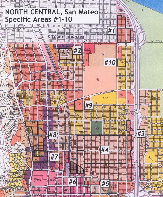
6 Specific Area #1 Review Requested: Rezone from R3 (medium density multi-family) to R1 (single family) the residential area north of Peninsula Avenue between Humboldt Street and Amphlett Boulevard. This area is currently designated for medium density multi-family (R3). The majority of the properties are developed with single family and duplex dwellings, especially to the west of Idaho Street. Of the 45 parcels west of Idaho Street, 3 contain multi-family dwellings, 14 properties have two units, and 28 are single family residences. On the east side of Idaho Street there are 5 multi-family properties, 5 duplex dwellings and 3 single family residences. This residential area is bordered by service commercial zoning to the east and north. Staff Recommendation: Staff is not recommending rezoning this area from R3 to R1 for a variety of reasons. Several properties in this specific area border service commercial uses and the current R3 zoning designation will allow redevelopment at a density, building floor area, and building height, that provides a buffer from the commercial areas and US 101 to the lower density duplex and single family properties. Changing this area to R1 would reduce the maximum allowed building mass from a floor area ratio of.85 to.5, and also reduce the building height from a maximum of 35 feet to 24 feet, thereby reducing the area s effectiveness as a transitional buffer from commercial uses and US 101. The east side of Idaho Street contains 13 properties, 10 of which are either multi-family or duplex dwellings. These 10 properties would become legal non-conforming uses. On the west side of Idaho Street, 38 percent (17 of 45) of the properties would become legal nonconforming. In addition, during the review of this area, staff sent notices to property owners informing them that the City will be looking at the potential for rezoning their property. Staff received 11 responses to this notice, 9 of which objected to the change to R1. Property owners indicated that they purchased the property for development potential and cited a loss of property value among their most prominent concerns (see attached responses). One owner favored rezoning to preserve single family character and quality of life, and another owner had issues with traffic speeds and no rezoning comment. 6
7 7
8 Specific Area #2 Review Requested: Rezone to R3 (medium density multi-family) the area bordering Studio Circle that is currently zoned R4 (high density multi-family). The Studio Circle area was developed in the early 1960 s with 6 and 7 unit apartment buildings on each lot, with the exception of two lots that have 12 and 16 units. The majority of the properties are built-out at 85 percent of the maximum permitted floor area or higher (1 property at 32 percent and 3 properties at 60 to 70 percent). This area is bordered by executive office and single family zoning. Staff Recommendation: Staff is not recommending rezoning this area from R4 to R3 since all but one of the properties would become legal non-conforming with respect to the maximum allowed R3 density. Since there is significant development on the properties, the potential for redevelopment in this area is low. 8
9 9
10 Specific Area #3 Review Requested: Rezone from R3 (medium density multi-family) to R2 (low density multi-family) the area on the east side of North Idaho Street between East Santa Inez and Second Avenue. Area 3 is generally bounded by single family and duplex zoning to the west and north, multiple family zoning to the south, and service commercial to the east. Of the 46 properties in this area, 11 are developed with multi-family dwellings, 7 have two units, and the remaining 28 parcels contain single family dwellings. The two large parcels located north of Monte Diablo Avenue are developed with both 18 and 16 unit apartment buildings. Existing development in the remainder of the area is mixed among multi-family, duplex, and single family without an apparent pattern of development. Staff Recommendation: Staff is not recommending rezoning this area from R3 to R2. Development on the two large Properties north of Monte Diablo Avenue would become legal non-conforming, as would 9 other properties in the area. Development at the existing R3 densities and allowable floor area and building height will provide a more substantial buffer to properties west of this area from the service commercial areas located to the east along US 101. Changing this area to R2 would reduce the maximum allowed building mass from a floor area ratio of.85 to.6, and also reduce the building height from a maximum of 35 feet to 24 feet, thereby reducing the area s effectiveness as a transitional buffer from commercial uses and US 101. Staff also sent notices to property owners in this area informing them that the City will be looking at the potential for rezoning their property. Staff received 7 responses to this notice. 3 property owners favored rezoning to reduce density, 2 owners objected to the change, and 2 did not specifically comment on rezoning (see attached responses). 10

11 11
12 Specific Area #4 Review Requested: Rezone to R1 (single family) the area bounded by Cypress Avenue, North Idaho Street, Monte Diablo Avenue, Claremont and Delaware streets (currently R2 low density multifamily). This area contains a total of 269 parcels, including 24 multi-family parcels, 83 duplex properties, and 162 single family dwellings. Approximately 40 percent (107 of 269 properties) of this area is comprised of either duplex or multi-family properties. Staff Recommendation: Staff is not recommending rezoning this area to single family due to the large amount of duplex properties (83) that will become legal non-conforming. (The 24 multi-family parcels are currently legal non-conforming because this area had previously been downzoned to R2.) In addition, staff looked at the pattern of development in the area to determine if sections of this area could be effectively downzoned without creating a large number of legal non-conforming uses. The existing mix of single family and duplex parcels does not provide a clear pattern of predominately single family areas where rezoning would limit the creation of non-conforming uses. A significant portion of this specific area is within walking distance to the Transit Center. Keeping this area zoned for duplex dwellings supports City goals and policies regarding providing more housing opportunities in proximity to train stations. 12
13 13
14 Specific Area #5 Review Requested: Rezone from R3 (medium density multi-family) to R2 (low density multi-family) the area north of Second Avenue between Fremont Street and Delaware Street. This area is located in the Gateway Area within the boundaries of the Downtown Specific Plan. The land use designation is medium density multi-family (R3). Existing development consists of a mixture of 5 single family dwellings, 4 duplex properties, 2 multi-family developments, and a mixed use duplex and commercial property located on the corner of Second Avenue and Fremont Street. Staff Recommendation: Staff is not recommending rezoning this area from R3 to R2 since this area is located in close proximity (approximately 2 ½ blocks) to the City s Transit Center. It is important to provide housing opportunities within walking distance to public transportation. Rezoning this area to R2 would limit redevelopment in an area where access to the train station by pedestrians is possible. In addition, the R3 zoning designation provides a transition from the high density area to the south and the duplex zoned area to the north. 14
15 15
16 Specific Area #6 Review Requested: Downzone to R4 (high density multi-family) and R3 (medium density multi-family) the area bounded by the rail corridor to the west, Cypress Avenue, South Claremont Street, and First Avenue, currently designated R6-D (high density downtown) and R4-D (high density downtown). This area is located in the both the Gateway and Central Claremont areas in the Downtown Specific Plan. The R6-D portion of this area is located directly across the rail corridor from the City s Transit Center, and contains a mix of commercial and residential land uses. The R4-D portion lies to the east one block from the Transit Center. Staff Recommendation: As in Specific Area #5, staff is not recommending down-zoning this area due to its proximity to the Transit Center. High density housing in this area is critical to the City s goals and policies of providing housing near transportation corridors. In addition, the floor area ratio in the R6-D area (3.0) allows development with sufficient building mass to provide a buffer from the rail corridor to properties to the east. The rezoning to R4 (1.5 floor area ratio) will result in smaller buildings and less building mass for a buffer. 16
17 17
18 Specific Area #7 Review Requested: Rezone to R3 (medium density multi-family) the area bounded by Tilton Avenue, El Camino Real, St. Matthews Avenue, and North San Mateo Drive, currently zoned R5 (high density multi-family) and mixed use E2-.5/R5 (executive office with high density residential). This area is located in the North B/Tilton Avenue Area within the boundaries of the Downtown Plan. Existing land uses include commercial offices, multi-family residential developments, two duplex and two single family parcels. This specific area does not include the single family dwellings on Tilton Terrace. Staff Recommendation: Staff is not recommending changes to the land use pattern and zoning designations in this specific area. The existing high density and mixed use designations allow for higher density housing in close proximity to downtown businesses, restaurants, and employment locations, and since it is adjacent to El Camino Real, allows for alternative transportation modes to support the higher residential density. This area is also within walking distance of the downtown Transit Center and as such is a good location for high density housing. In addition, General Plan policies support, and in some cases encourage, the concept of mixed use zoning in non-residential areas. It is important to retain the underlying office zoning designation in this area to provide needed services to the community. San Mateo Drive has many medical and general office uses that would become legal non-conforming uses. Although rezoning to R3 would allow the existing uses to remain, future development would be restricted to medium density residential, and the non-residential uses would be lost. 18
19 19
20 Specific Area #8 Review Requested: Rezone to R3 (medium density multi-family) the area bounded by El Camino Real, East Santa Inez, Elm Street, and Tilton Avenue, currently zoned both R5 (high density multifamily) and R4 (high density multi-family). This area encompasses portions of several city blocks and is located to the north of the boundary of the Downtown Plan area. Existing residential uses are mixed with predominantly multi-family dwellings, three single family dwellings, and two religious institutions. The majority of the multi-family dwellings have been constructed at or near the maximum floor area and high density designation permitted on the properties. Staff Recommendation: Similar to Specific Area #7, staff is not recommending changes to the land use pattern and zoning designations in this specific area. The existing high density designations allow for higher density housing in close proximity to downtown businesses, restaurants, and employment locations. This area also is near El Camino Real, which provides options for transportation. The Land Use Element of the General Plan also has specific policies and associated text that requires high density residential in this area. PA 1.3: East Santa Inez Avenue/Tilton Avenue Neighborhood. Provide for high-density multi-family uses between East Santa Inez and Tilton avenues, with the exception of the single-family residences on Chesterton Court, to support downtown commercial development. The area is characterized by high-density residential buildings three stories in height, with the exception of Chesterton Court, which is lined by single-family dwellings. High-density redevelopment is appropriate because the neighborhood is within walking distance of the Downtown retail core. PA 1.1: North El Camino Real. Retain the high density residential character of the area between Peninsula and Tilton avenues. Commercial sites in the area should redevelop where appropriate to medium scale office uses, as delineated on the Building Height and Intensity Plans, or high density residential. Commercial redevelopment shall be designed to reflect the residential design and character of the area. North El Camino Real is characterized by multi-family developments two to three stories in height with some small scattered non-residential sites. Redevelopment of the non-residential sites to multi-family residential is appropriate to create more neighborhood uniformity and less nuisances for neighbors such as visual blight, glare, noise, traffic and parking congestion. This specific area contains R4 and R5 parcels that front El Camino Real. The requirement for high density on these parcels comes from Measure P language (see italics above) and may not be changed. 20
21 21
22 Specific Area #9 Review Requested: Rezone from R3 (medium density multi-family) to R2 (low density multi-family) the large parcel located on the southeast corner of East Poplar Avenue and North Claremont Street. This property is currently owned and used by the California Water Service Company. Redevelopment of the property at medium density would yield a maximum of 116 dwelling units. At the proposed lower density, approximately 58 units could be constructed. Staff Recommendation: Staff does not recommend changes to this area because the R3 medium density residential designation is consistent with the R3 properties on the other 3 corners of the intersection of East Poplar and North Claremont. Although this site borders single family areas, the City s development standards for increased setbacks/buffers adjacent to single family and the multi-family design guidelines would provide for a building mass and height transition on the site to the single family neighborhood to the south. 22
23 23
24 Specific Area #10 Review Requested: Review zoning and land use for the County Courthouse, currently zoned R1 (single family). This site is owned by the County of San Mateo and used as a county court facility. The City of San Mateo does not have land use jurisdiction over San Mateo County owned property, with the exception of review of County development proposals for conformance with the City s General Plan. The General Plan designates the site as a Public Facility. The R1 zoning delineates the type and intensity for redevelopment of the site to match surrounding single family residences if the County sells the property. Staff Recommendation: Since this site is located in close proximity to a single family area, the R1 zoning of this site is appropriate for redevelopment. 24
25 25
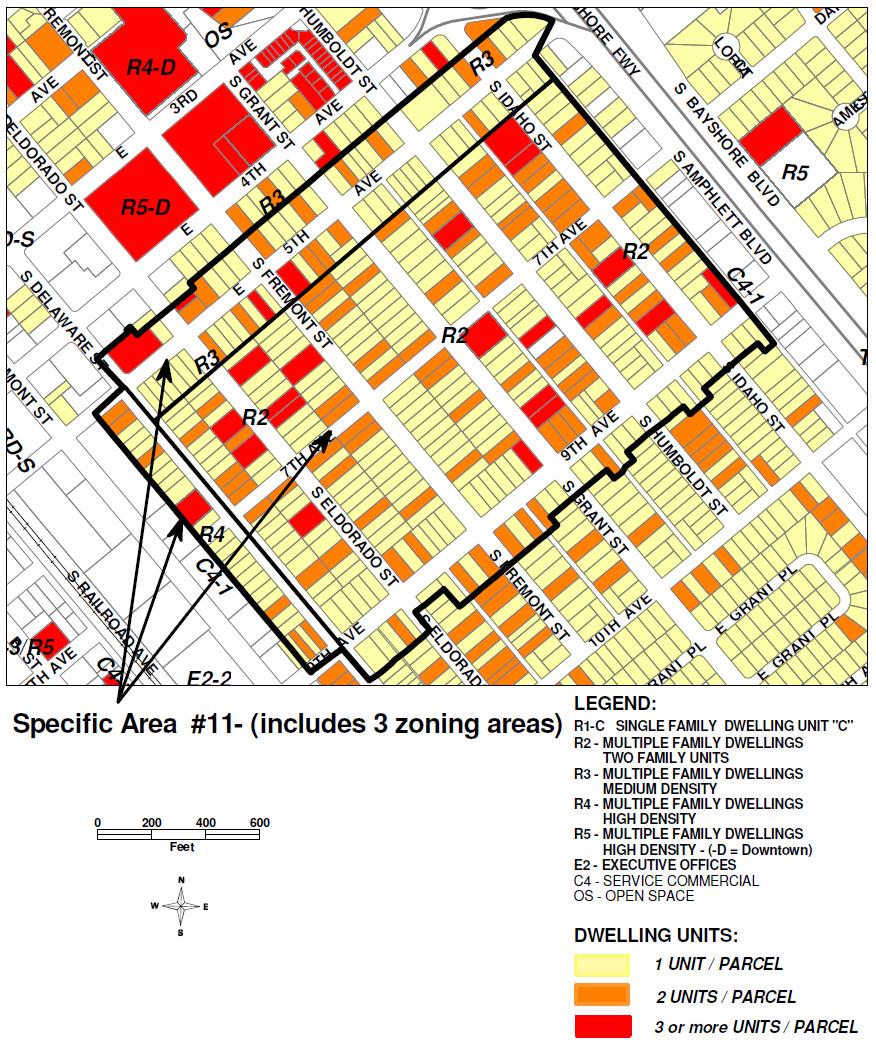
26 Specific Area #11 Review Requested: Rezone the area from Idaho Street to both sides of Delaware Street, Fifth Avenue, and Ninth Avenue to R1 (single family residential) from R2 (low density multi-family), R3 (medium density multi-family) and R4 (high density multi-family). The majority of this area is currently designated low density residential (zoned R2, two family dwellings). Properties on the west side of Delaware Street are designated high density residential (zoned R4, multiple family dwellings), and properties on both sides of Fifth Avenue are designated medium density residential (zoned R3, multiple family dwellings). Properties on the north side of Fifth Avenue are located in the Gateway Area within the boundaries of the Downtown Plan. It should be noted that the 1990 General Plan rezoned the majority of properties in this area from R3 to R2, with the exception of the Fifth Avenue area which was rezoned from R4 to R3. Representatives of the Central Neighborhood Association submitted a map indicating that this area is developed with 67 percent single family dwellings, 27 percent duplexes, and 7 percent multifamily dwellings. They also submitted a petition, containing 116 signatures, supporting a rezoning of this area to R1 (single family). The petition stated the goals of the neighborhood. Major goals include: Preserve the character and protect the property values of our single-family neighborhood by prohibiting the construction of new duplex units. Granny units could still be built, and Allow the neighborhood to qualify for traffic calming programs. Our existing R-2, R-3, R-4 zoning makes it easy to route traffic through our streets. The map and petition are attached. Staff Recommendation: Staff is not recommending a change in zoning to R1 for this specific area. The majority of this specific area is zoned R2. This area was rezoned from R3 to R2 as part of the adoption of the General Plan in This R2 area contains a total of 291 parcels, including 19 multi-family parcels, 75 duplex properties, and 197 single family dwellings. Approximately 32 percent (94 of 291 properties) of this area is comprised of either duplex or multi-family properties. Staff is not recommending rezoning this area to single family due to the large amount of duplex properties (75) that will become legal non-conforming. Staff looked at the pattern of development in the area to determine if sections of this area could be effectively downzoned without creating a large number of legal non-conforming uses. The existing mix of single family and duplex parcels does not provide a clear pattern of predominately single family areas where rezoning would limit the creation of nonconforming uses. The R4 zoned properties on the west side of Delaware Street (1 multi-family development, 6 duplex properties, 20 single family dwellings) provide a good transition to the neighborhood from the C4 (service commercial) and CBD-S (downtown support) areas to the west. Redevelopment at higher densities and potentially larger buildings will help to buffer the commercial activity from lower density areas to the east. The R3 zoning designation on the properties on both sides of Fifth Avenue (4 multi-family developments, 14 duplex properties, and 49 single family dwellings) is appropriate in that this area 26
27 provides a necessary transition from the higher density zoning in the downtown Gateway Area to the north. Staff sent notices to property owners informing them that the City will be looking at the potential for rezoning their property. Staff received 22 responses to this notice, 9 of which objected to the change to R1. Concerns expressed included: purchased the property for development potential, loss of property value, concern over creating a lot of nonconforming properties, and the need for more modern multi-family buildings. Five property owners supported the downzoning, citing privacy issues, overcrowding of people and vehicles, noise traffic, consistency of single family dwellings in the neighborhood, need to maintain owner occupancy, and that streets should not be collectors. Eight persons asked for more information about the rezoning and staff responded to these requests. Responses are attached. 27
28 28
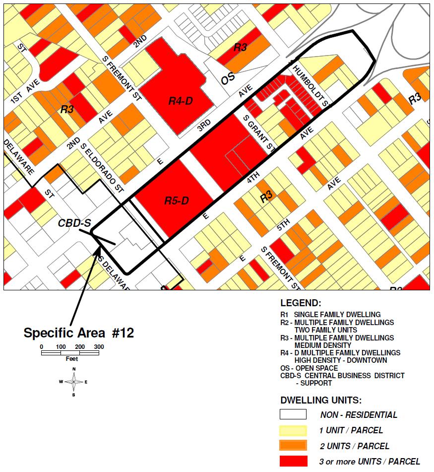
29 Specific Area #12 Review Requested: Reduce density on Third and Fourth Avenues from Idaho Street to Delaware Street. This area is located in the Gateway Area within the boundaries of the Downtown Plan. The land use designation is both high density residential (R5-D, high density downtown) and downtown retail core support (CBD-S, Central Business District Support). Existing development consists of a range of low to high density residential uses with commercial uses to the west of Eldorado Street. Staff Recommendation: Staff is not recommending density reductions this area. The area zoned CBD-S is a commercial shopping center. Although residential density is 50 units per acre (high density) on this site, residential is only permitted as part of a mixed use development in the CBD-S zone. Since the center was recently remodeled, the redevelopment potential on this site is relatively low. The R5-D area, located between Third and Fourth Avenues, is a major entrance to the City and redevelopment has taken place on most of the blocks (Metropolitan, Humboldt Square). Remaining properties should be developed at high density to maintain consistency of density and project size within this gateway to the downtown. 29
30 30
31 Specific Area #13 Review Requested: Replace the service commercial zoning on South Amphlett Boulevard from Fifth Avenue to Folkstone to low density residential. This area is designated service commercial (C4-1, service commercial) and lies between residential properties to the west and South Amphlett Boulevard adjacent to the US 101 freeway. Representatives of the Central Neighborhood Association submitted a petition (attached) containing 106 signatures, requesting rezoning of this area to residential use. The petition stated impacts from truck traffic in the neighborhood and environmental impacts of hazardous and flammable materials used by businesses in the area as the primary reasons for the land use change. Staff Recommendation: Staff is recommending that this area be retained for service commercial (C4) uses. The current General Plan Land Use Element has specific policies aimed at preserving service commercial areas in the City. LU 1.13 Service Commercial Uses. Encourage the retention of service commercial areas to provide convenient access and a balanced local economy at intensities and locations delineated on the Land Use plan and the Building Intensity Plan. Service commercial uses, including auto and truck repair, building material yards, and animal hospitals, are recognized as important components of the overall land use mix. They provide convenient access to needed services, generate tax revenues, and contribute to a diverse employment base. However, given the nature of these uses, provisions are needed to minimize nuisance impacts such as noise, odors, litter and visual blight, especially near residential neighborhoods. This may include limitations on outdoor storage, screening, and upgrade of buildings. Major service commercial strips include: Amphlett Boulevard, Claremont/Railroad Avenue and Palm Avenue. PA 5.4: Service Commercial Uses. Retain the service commercial uses along South Amphlett Boulevard, South Claremont Street, Railroad Avenue and Leslie Street. These policies clearly establish the City s desire to retain service commercial areas. Amphlett Boulevard is specifically mentioned in the text, and policy PA 5.4 addresses the Hayward Park Planning Area where Specific Area #13 is located. It should be noted that staff is proposing to revise Policy LU 1.13 in the land Use Element to reflect Measure P language that residential is not permitted in service commercial areas as shown below. The proposed policy revision still emphasizes the need to maintain existing service commercial areas. 31

32 Proposed policy revision: LU 1.13: Prohibit Residential Uses in Service Commercial/Manufacturing Areas. To promote the retention of service commercial areas which provide vital community services, convenient service access, and a balanced local economy prohibit new residential development in service commercial/manufacturing areas delineated on the Land Use Plan. Require businesses locating adjacent to residential areas to minimize nuisance impacts such as noise, odors, lighting glare, litter, intrusion of overflow parking and traffic. 32
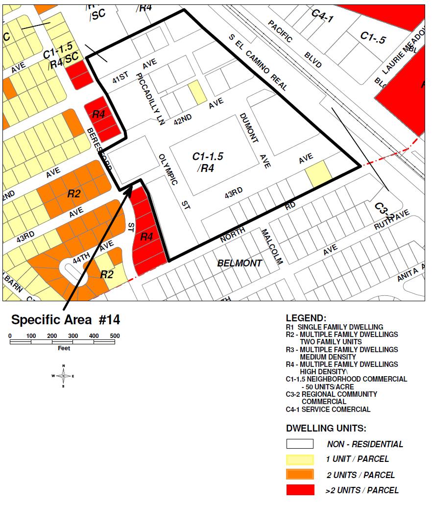
33 Specific Area #14 42 nd Avenue Area. Review Requested: The issue of increasing residential density in the 42 nd Avenue area was raised at the public workshop and TAC meeting related to land use changes. Staff Recommendation: Staff is not recommending any changes to this area. The General Plan designates this area for mixed use as Neighborhood Commercial/High Density Residential (50 units per acre). In addition, General Plan Land Use Element Policy PA 9.1 requires the preparation of a specific plan to determine land use compatibility, site planning, and circulation in the area. The policy and associated text states the following: PA 9.1: Forty-Second Avenue Center. Develop a Specific Plan for the area between 41st Avenue, Beresford Street, South El Camino Real (SR 82) and the Belmont border to improve the efficiency of the site design, circulation, appearance, and design relationship to surrounding uses, and to allow mixed commercial and residential expansion. Allow heights and intensities/densities as delineated on the Building Height and Intensity Plans. The 42nd Avenue Shopping Center is intended to be the major neighborhood retail center in the southern portion of the City. Problems such as circulation, parking, access, and appearance have limited the market performance of the area. A Specific Plan will be prepared to address these problems and to maximize the center's economic vitality, provide housing opportunities, and encourage mixed use. In addition, the El Camino Real Master Plan states that this area should be developed to create a neighborhood oriented mixed-use center that serves as a gateway into San Mateo. Land use objectives include the establishment of a mixed-use plan that includes significant retail along El Camino Real, a neighborhood supermarket, and higher intensity residential development. Redevelopment in this area will be evaluated in conformance with the guidelines and policies contained in the Master Plan. As such, no change to this area is recommended. 33
34 34
APPENDIX B RESIDENTIAL DENSITY
 APPENDIX B RESIDENTIAL DENSITY RESIDENTIAL DENSITY - SPECIFIC AREAS OF THE CITY Policy Issue Examine specific areas of the City to determine appropriate residential densities. Public comments have expressed
General Plan. Page 44
 VIII. RESIDENTIAL DEVELOPMENT IN NON-RESIDENTIAL LAND USE AREAS POLICY ISSUE Review the City s existing regulations and policies that allow residential land use in non-residential zoning districts. BACKGROUND
VI. RESIDENTIAL DENSITY
 VI. RESIDENTIAL DENSITY POLICY ISSUE Examine residential density regulations, looking at the potential for lowering densities and the impact on the City s Housing Element of the General Plan. BACKGROUND
Plan Area and Current Facilities
 Plan Area and Current Facilities The Plan Area is bounded by South Delaware Street to the east and Concar Drive to the south (Figure 2.01). Parallel to Concar Drive on the south, SR 92 rises above grade
Provide a diversity of housing types, responsive to household size, income and age needs.
 8 The City of San Mateo is a highly desirable place to live. Housing costs are comparably high. For these reasons, there is a strong and growing need for affordable housing. This chapter addresses the
ARTICLE 3: Zone Districts
 ARTICLE 3: Zone Districts... 3-1 17.3.1: General...3-1 17.3.1.1: Purpose and Intent... 3-1 17.3.2: Districts and Maps...3-1 17.3.2.1: Applicability... 3-1 17.3.2.2: Creation of Districts... 3-1 17.3.2.3:
Chapter 1107: Zoning Districts
 Chapter 1107: Zoning Districts 1107.01 Establishment of Zoning Districts (a) Districts Established In order to carry out the purpose of this code, the City is hereby divided into the zoning districts established
A. Districts Concept
 L A N D U S E 6 This chapter discusses the land use concept and provides land use designations for Downtown, including associated development intensities that will apply in Downtown. In order to support
ARTICLE B ZONING DISTRICTS
 ARTICLE B ZONING DISTRICTS Sec. 8-3021 Established. In order to protect the character of existing neighborhoods; to prevent excessive density of population in areas which are not adequately served with
Midwest City, Oklahoma Zoning Ordinance
 2010 Midwest City, Oklahoma Zoning Ordinance 9/2/2010 Table of Contents Section 1. General Provisions... 5 1.1. Citation... 5 1.2. Authority... 5 1.3. Purpose... 5 1.4. Nature and Application... 5 1.5.
CITY OF NAPLES STAFF REPORT
 Meeting of 05/13/15 Conditional Use Petition 15-CU3 CITY OF NAPLES STAFF REPORT To: Planning Advisory Board From: Planning Department Subject: Conditional Use Petition 15-CU3 Petitioner: Hazelden Betty
891941, , : COMPREHENSIVE PLAN AMENDMENT, COMMUNITY PLAN AMENDMENT, AND AREA-WIDE MAP AMENDMENT
 Application Nos. 891941, 891909, 891940: COMPREHENSIVE PLAN AMENDMENT, COMMUNITY PLAN AMENDMENT, AND AREA-WIDE MAP AMENDMENT Amendments to designate five parcels as Rural Industrial Center in the Alderton
PLANNING COMMISSION WILLIAMSBURG, VIRGINIA WORK SESSION AGENDA Wednesday, May 23, 2012
 PLANNING COMMISSION WILLIAMSBURG, VIRGINIA WORK SESSION AGENDA Wednesday, May 23, 2012 The meeting will be called to order in the third floor Conference Room (Room 310), Williamsburg Municipal Building,
York Neighbourhood Area Structure Plan
 York Neighbourhood Area Structure Plan Office Consolidation March 2006 Prepared by: Planning and Policy Services Branch Planning and Development Department City of Edmonton Bylaw 7064 was adopted by Council
SECTION 3. Housing. Appendix A LAND USE DEFINITIONS
 SECTION 3 Housing A Appendix A LAND USE DEFINITIONS A-2 Housing Commission Attachment B Appendix A Land Use Definitions INTRODUCTION The Land Use Map (Figure A-1) of Community Vision 2040 illustrates the
Bylaw No , being "Official Community Plan Bylaw, 2016" Schedule "A" DRAFT
 Bylaw No. 2600-2016, being "Official Community Plan Bylaw, 2016" Schedule "A" Urban Structure + Growth Plan Urban Structure Land use and growth management are among the most powerful policy tools at the
ARTICLE 3 ZONING DISTRICTS AND ZONING MAP. Table of Contents
 ARTICLE 3 ZONING DISTRICTS AND ZONING MAP Table of Contents 3-1 Establishment of Zoning Districts... 1 A. General Use Zoning Districts... 1 B. Conditional Zoning Districts... 3 C. Overlay Zoning Districts...
NORTHWEST QUADRANT NEIGHBORHOOD STUDY
 City of Novato General Plan 2035 Focus Area NORTHWEST QUADRANT NEIGHBORHOOD STUDY May, 2015 Why a Neighborhood Study? The Northwest Quadrant Neighborhood, north of the Grant Avenue business district,
DIVISION 1 PURPOSE OF DISTRICTS
 ARTICLE 2 ZONING DISTRICTS AND MAP DIVISION 1 PURPOSE OF DISTRICTS Section 2.101 Zoning Districts. For the purpose of this Ordinance, the City of Richmond is hereby divided into districts as follows: DISTRICT
LAND USE ELEMENT CITY OF HAWTHORNE GENERAL PLAN
 LAND USE ELEMENT CITY OF HAWTHORNE GENERAL PLAN Adopted April, 1990 Last amended March, 2016 Prepared by: Cotton/Beland/Associates, Inc. 1028 North Lake Avenue, Suite 107 Pasadena, California 91104 TABLE
GENERAL DESCRIPTION STAFF RECOMMENDATION IMPLEMENTATION REQUIREMENTS
 Application No.: 891418 Applicant: AREA-WIDE MAP AMENDMENT Rezone two parcels from Moderate Density Single Family (MSF) to Neighborhood Center (NC) and Employment Center (EC). Charles Bitton GENERAL DESCRIPTION
United States Post Office and Multi-Family Residential; and, Single- Family Residence with an Apartment
 Planning Commission File No.: AME2013 0009 January 9, 2014 Page 2 of 9 Existing Land Use: United States Post Office and Multi-Family Residential; and, Single- Family Residence with an Apartment Surrounding
STAFF REPORT. Community Development Director PO Box 4755 Beaverton, OR 97076
 STAFF REPORT HEARING DATE: July 7, 2010 TO: Planning Commission STAFF: Jana Fox, Assistant Planner PROPOSAL: Southeast Beaverton Office Commercial Zoning Map Amendment (ZMA2010-0006) LOCATION: The subject
Appendix A: Guide to Zoning Categories Prince George's County, Maryland
 Appendix A: Guide to Zoning Categories Prince George's County, Maryland RESIDENTIAL ZONES 1 Updated November 2010 R-O-S: Reserved Open Space - Provides for permanent maintenance of certain areas of land
Place Type Descriptions Vision 2037 Comprehensive Plan
 Place Type Descriptions Vision 2037 Comprehensive Plan The Vision 2037 Comprehensive Plan establishes a range of place types for Oxford, ranging from low intensity (limited development) Rural and Natural
CITY OF CHARLOTTESVILLE DEPARTMENT OF NEIGHBORHOOD DEVELOPMENT SERVICES STAFF REPORT APPLICATION FOR A SPECIAL USE PERMIT
 CITY OF CHARLOTTESVILLE DEPARTMENT OF NEIGHBORHOOD DEVELOPMENT SERVICES STAFF REPORT APPLICATION FOR A SPECIAL USE PERMIT PLANNING COMMISSION AND CITY COUNCIL JOINT PUBLIC HEARING DATE OF HEARING: December
A DJUSTMENTS. A. Zoning Permits Required: Use Permit to construct a dwelling unit, as required by BMC Section 23D
 Z O N I N G A DJUSTMENTS B O A R D S t a f f R e p o r t FOR BOARD ACTION AUGUST 14, 2008 2421 Ninth Street Use Permit 05-10000084 to construct a two-story 1,766 sq. ft., detached dwelling unit at the
Bunker Hill Part II Urban Design. Specific Plan. Case No. CPC SP TABLE OF CONTENTS
 Bunker Hill Part II Urban Design Specific Plan Case No. CPC-2011-684-SP TABLE OF CONTENTS Section 1. Section 2. Section 3. Section 4. Section 5. Section 6. Section 7. Section 8. Section 9. Section 10.
City of Valdosta Land Development Regulations
 Chapter 206 Section 206-1 Base Zoning Districts Standards for Uses, Structures, and Property Development (B) (C) Principal Uses and Structures. Principal uses and structures permitted in each base zoning
3.1. OBJECTIVES FOR RESIDENTIAL LAND USE DESIGNATIONS GENERAL OBJECTIVES FOR ALL RESIDENTIAL DESIGNATIONS
 3. RESIDENTIAL LAND USE DESIGNATIONS INTRODUCTION The Residential land use designations provide for housing and other land uses that are integral to, and supportive of, a residential environment. Housing
Glades County Staff Report and Recommendation Unified Staff Report for Small Scale Plan Amendment and Rezoning
 Glades County Staff Report and Recommendation Unified Staff Report for Small Scale Plan Amendment and Rezoning CASE NUMBERS: COMP17-02 and RZ17-02 DATE of STAFF REPORT: May 1, 2017 CASE TYPE: Application
4 DEVELOPMENT STANDARDS FOR
 4 DEVELOPMENT STANDARDS FOR RESIDENTIAL MIXED-USE PROJECTS This chapter presents standards for residential mixed-use projects in the Ashland-Cherryland Business District and the Castro Valley Central Business
Poughkeepsie City Center Revitalization Plan
 Purpose and Need Purpose Increase job and educational opportunities for all residents Maximize fiscal productivity of downtown land uses Diversify retail mix Eliminate surface and building vacancies Create
Marcel Williams, MPC Project Planner
 TO: FROM: The Planning Commission MPC Staff DATE: SUBJECT: Petition to Rezone Property Heath Shelton, Owner Jay Maupin, Agent 2026 Habersham Street Aldermanic District: 2, Bill Durrence County Commission
CITY OF SANTA ROSA COMMUNITY DEVELOPMENT DEPARTMENT STAFF REPORT FOR PLANNING COMMISSION SEPTEMBER 10, 2015 APPLICANT FILE NUMBER MJP
 ITEM NO. 9 CITY OF SANTA ROSA COMMUNITY DEVELOPMENT DEPARTMENT STAFF REPORT FOR PLANNING COMMISSION SEPTEMBER 10, 2015 PROJECT TITLE Yogurt Time Center ADDRESS/LOCATION 3093 Marlow Road ASSESSOR S PARCEL
Evolution of the Vision for NE 181st Street Study Area
 City Council Action on NE 181 St Street Study Area Evolution of the Vision for NE 181st Street Study Area such uses to ensure neighborhood compatibility. More intense uses may be allowed through a conditional
SAN IPSE CAPITAL OF SILICON VALLEY
 COUNCIL AGENDA: 01/10/17 ITEM: 11.1(b) CITY OF SAN IPSE CAPITAL OF SILICON VALLEY CITY COUNCIL STAFF REPORT File No. C16-048 Applicant: Terry Pries Location 320 Race Street Existing Zoning LI Light Industrial
4 LAND USE 4.1 OBJECTIVES
 4 LAND USE The Land Use Element of the Specific Plan establishes objectives, policies, and standards for the distribution, location and extent of land uses to be permitted in the Central Larkspur Specific
City of Sacramento Zoning Code - Zoning Descriptions Excerpt from website on April 5, 2010
 City of Sacramento Zoning Code - Zoning Descriptions Excerpt from website on April 5, 2010 RE Rural Estates Zone. This is a very low density residential zone. It is intended to be applied primarily to
Planning Justification Report
 Planning Justification Report Kellogg s Lands City of London E&E McLaughlin Ltd. June 14, 2017 Zelinka Priamo Ltd. Page i TABLE OF CONTENTS Page No. 1.0 2.0 2.1 2.2 3.0 4.0 5.0 5.1 5.2 5.3 5.4 5.5 5.6
DRAFT FOR DISCUSSION PURPOSES ONLY. Port Credit Local Area Plan Built Form Guidelines and Standards DRAFT For Discussion Purposes
 Port Credit Local Area Plan Built Form Guidelines and Standards DRAFT For Discussion Purposes 1 Local Area Plan - Project Alignment Overview Directions Report, October 2008 (General Summary Of Selected
THE REDEVELOPMENT PLAN
 PAGE 37 THE REDEVELOPMENT PLAN FUTURE LAND USE The Silver Terrace Redevelopment Area is currently designated as Redevelopment Area #4 on the City of Delray Beach Future Land Use Map (FLUM). This designation
Salem HNA and EOA Advisory Committee Meeting #6
 Salem HNA and EOA Advisory Committee Meeting #6 Residential Land Policies Employment Land Policies Policy Discussions with the Committee Outcome of today s meeting Direction from this Committee on proposed
Pierce County Comprehensive Plan Review
 2015-2016 Pierce County Comprehensive Plan Review March 16, 2016 Introduction Planning and Management Policies Some of the policies governing both the planning and management of growth and change within
2.2.2 The Land Use Setting
 2-6 Planning Area pearance varies dramatically from season to season. The absence of significant topographic or man-made features within the District contributes to a very open visual character that allows
COMMISSION ACTION FORM SUBJECT: ZONING TEXT AMENDMENT FOR LINCOLN WAY CORRIDOR PLAN DOWNTOWN GATEWAY COMMERCIAL ZONING DISTRICT STANDARDS
 ITEM #: 7 DATE: _02-07-18 COMMISSION ACTION FORM SUBJECT: ZONING TEXT AMENDMENT FOR LINCOLN WAY CORRIDOR PLAN DOWNTOWN GATEWAY COMMERCIAL ZONING DISTRICT STANDARDS BACKGROUND: The Downtown Gateway area
CHAPTER 2: ZONING DISTRICTS
 CHAPTER 2: ZONING DISTRICTS 2.1. GENERAL 2.1.1. Purpose To carry out the purpose and provisions of this Code, the County is divided into zoning districts. This chapter establishes the base zoning districts
PLANNING COMMISSION STAFF REPORT
 PLANNING COMMISSION STAFF REPORT West Capitol Hill Zoning Map Amendment Petition No. PLNPCM2011-00665 Located approximately at 548 W 300 North Street, 543 W 400 North Street, and 375 N 500 West Street
PLANNING COMMISSION STAFF REPORT
 PLANNING COMMISSION STAFF REPORT MEETING DATE: 16 May 2013 APPLICANT: V&K Investments, LLC REQUEST: Zoning Map Amendment for 3232 South 300 East ZONE: Single-Family Residential to Commercial Corridor PREPARED
LAND USE AND ZONING OVERVIEW
 OVERVIEW OF PLANNING POLICIES LAND USE AND ZONING OVERVIEW The Minneapolis Plan for Sustainable Growth and Other Adopted Plans Community Planning and Economic Development Development Services Division
Sherwood Forest (Trinity) Housing Corporation. Urban Design Brief
 Housing Corporation. Urban Design Brief") Sherwood Forest (Trinity) Housing Corporation Sherwood Place Affordable Housing Apartments Trinity Presbyterian Church Orchard Park Nursery School 590 Gainsborough Road, London Urban Design Brief REVISED
Sherwood Forest (Trinity) Housing Corporation Sherwood Place Affordable Housing Apartments Trinity Presbyterian Church Orchard Park Nursery School 590 Gainsborough Road, London Urban Design Brief REVISED
Mohave County General Plan
 63 64 65 66 67 68 69 70 71 The Land Use Diagram is not the County's zoning map. 13 It is a guide to future land use patterns. Zoning and area plan designations may be more restrictive than the land use
Planning & Transportation Commission Staff Report (ID # 8862)
") Planning & Transportation Commission Staff Report (ID # 8862) Report Type: Action Items Meeting Date: 2/14/2018 Summary Title: Title: From: Affordable Housing (AH) Combining District Draft Ordinance PUBLIC
Planning & Transportation Commission Staff Report (ID # 8862) Report Type: Action Items Meeting Date: 2/14/2018 Summary Title: Title: From: Affordable Housing (AH) Combining District Draft Ordinance PUBLIC
THE AREA PLAN COMMISSION OF ST. JOSEPH COUNTY, IN AGENDA
 THE AREA PLAN COMMISSION OF ST. JOSEPH COUNTY, IN AGENDA Tuesday, June 20, 2017 Fourth-Floor Council Chambers 3:30 p.m. County-City Building, South Bend, IN PUBLIC HEARINGS: 1. Rezonings: A. A combined
Master Plan Review SILVER SPRING CBD. Approved and Adopted February Updated January 2013
 Master Plan Review SILVER SPRING CBD Approved and Adopted February 2000 BACKGROUND ZONING CODE REWRITE In 2007, the Montgomery County Council directed the Planning Department to undertake a comprehensive
Oak Cliff Gateway District PD 468
 Oak Cliff Gateway District PD 468 August 21, 2014 2013 Authorized Hearing Authorized Hearing September, 2013 September 12, 2013 City Plan Commission expanded boundaries to represent current Oak Cliff Gateway
Request. Recommendation. Recommended Motion. Planning Division Department of Community and Economic Development
 PLANNING COMMISSION STAFF REPORT Legislative Item 900 South 900 East Rezone Zoning Map Amendment PLNPCM2010-00360 700 East 900 East, 700 South 900 South December 12, 2012 Applicant: City Council Luke Garrott
Introduction. General Development Standards
 Introduction The development standards will set the zoning regulations for the East Park development. This section will illustrate lot standards, approximate open space locations and road standards. The
Parking Challenges and Trade-Offs
 Parking Challenges and Trade-Offs What is the best way to balance competing interests and priorities while updating the City s off street parking regulations? Updating off street parking regulations can
CITY OF CHARLOTTESVILLE DEPARTMENT OF NEIGHBORHOOD DEVELOPMENT SERVICES STAFF REPORT APPLICATION FOR A SPECIAL USE PERMIT
 CITY OF CHARLOTTESVILLE DEPARTMENT OF NEIGHBORHOOD DEVELOPMENT SERVICES STAFF REPORT APPLICATION FOR A SPECIAL USE PERMIT PLANNING COMMISSION AND CITY COUNCIL JOINT PUBLIC HEARING DATE OF HEARING: July
SECTION CLASSIFICATION OF ZONES For the purpose of this Code the following primary land use zoning districts are hereby established:
 ARTICLE 4 ZONING DISTRICTS SECTION 4.010 CLASSIFICATION OF ZONES For the purpose of this Code the following primary land use zoning districts are hereby established: Primary Zones Abbreviated Designation
CITY OF PORT ORCHARD
 CITY OF PORT ORCHARD ZONING DESIGNATIONS (Adapted from POMC Chapter 20.34 Zoning Districts, as adopted 6/13/2017) 20.34.110 Greenbelt zone (Gb). (1) Purpose. It is the purpose of the greenbelt zone to
ATTACHMENT #1 SUMMARY CHART
 ATTACHMENT #1 SUMMARY CHART Item # Amendment To: Nature of Proposed Amendment PCM201801 PCM201802 PCM201803 PCM201804 LMA201802 LMA201803 LMA201804 PCT201801 PCT201802 PCT201803 FUTURE LAND USE MAP Parkway
Appendix B: Housing Element Sites Inventory and Detailed Analysis
 Appendix B: 2015-2023 Housing Element Sites Inventory and Detailed Analysis Redwood City General This page intentionally left blank. Redwood City General Site Identifier Assessor Parcel Number General
PIN , Part 1, Plan SR-713 in Lot 2, Concession 5, Township of McKim (1096 Dublin Street, Sudbury)
") STAFF REPORT Applicant: Dalron Construction Limited Location: PIN 02124-0103, Part 1, Plan SR-713 in Lot 2, Concession 5, Township of McKim (1096 Dublin Street, Sudbury) Official Plan and Zoning By-law:
STAFF REPORT Applicant: Dalron Construction Limited Location: PIN 02124-0103, Part 1, Plan SR-713 in Lot 2, Concession 5, Township of McKim (1096 Dublin Street, Sudbury) Official Plan and Zoning By-law:
City of Coral Gables Planning and Zoning Staff Report
 City of Coral Gables Planning and Zoning Staff Report Applicant: Application: Public Hearing: Date & Time: Location: City of Coral Gables Giralda Restaurant Row Overlay Zoning Code Text Amendment Planning
STAFF REPORT. Permit Number: Unlimited. Kitsap County Board of Commissioners; Kitsap County Planning Commission
 STAFF REPORT Permit Number: 15 00550 Unlimited DATE: March 2, 2016 TO: FROM: Kitsap County Board of Commissioners; Kitsap County Planning Commission Katrina Knutson, AICP, Senior Planner, DCD and Jeff
AGENDA ITEM SUMMARY GLADES COUNTY BOARD OF COUNTY COMMISSIONERS
 AGENDA ITEM SUMMARY GLADES COUNTY BOARD OF COUNTY COMMISSIONERS SUBJECT: Case Number COMP17-01, Legend Moto LLC This is a Legislative Hearing. DEPARTMENT REQUEST: The Community Development Department requests
SECTION 4 ZONING DISTRICTS
 SECTION 4 ZONING DISTRICTS Sec. 4-1 Establishment of Districts. In order to protect the character of existing neighborhoods, to prevent excessive density of population in areas which are not adequately
Creative Approaches to Land Acquisition
 2007 Legislative Session Review CALIFORNIA TRANSIT ASSOCIATION JANUARY/FEBRUARY 2008 Creative Approaches to Land Acquisition Result From Creative Approaches to Land Acquisition It should not surprise anyone
P. H. Robinson Consulting Urban Planning, Consulting and Project Management
 PLANNING RATIONALE REPORT FOR SITE PLAN AND DRAFT PLAN OF CONDOMINIUM APPLICATIONS 73-75 HARVEY STREET CITY OF OTTAWA PREPARED BY: P H ROBINSON CONSULTING AUGUST 2012 1 This report has been prepared on
CITY PLANNING COMMISSION CITY OF NEW ORLEANS EXECUTIVE DIRECTOR. City Planning Commission Staff Report. Executive Summary
 CITY PLANNING COMMISSION CITY OF NEW ORLEANS MITCHELL J. LANDRIEU MAYOR ROBERT D. RIVERS EXECUTIVE DIRECTOR LESLIE T. ALLEY DEPUTY DIRECTOR City Planning Commission Staff Report Zoning Docket 092/16 Executive
June 22, 2005/Calendar No. 14
 CITY PLANNING COMMISSION June 22, 2005/Calendar No. 14 C 050400 ZMQ IN THE MATTER OF an application submitted by the Department of City Planning pursuant to Sections 197-c and 201 of the New York City
M E M O. September 14, 2017 Agenda Item #4. Planning Commission. David Goodison, Planning Director
 September 14, 2017 Agenda Item #4 M E M O To: From: Planning Commission David Goodison, Planning Director Re: Preliminary review of an application for a mixed-use development proposed for 870 Broadway
Financial Impact Statement There are no immediate financial impacts associated with the adoption of this report.
 STAFF REPORT Planning and Development Department Subject: Application by RYC Property to rezone a portion of lands on John Murray Dr. and Megan Lynn Dr. from R2 to R3 and to enter into a Development Agreement
Highland Green Estates Neighbourhood Area Structure Plan
 Highland Green Estates Neighbourhood Area Structure Plan Original Outline Plan approved by Council: March 10, 1997 Outline Plan amended by Council: March 24, 1997 Converted to a Neighbourhood Area Structure
Master Plan Review WESTBARD
 Master Plan Review WESTBARD Approved and Adopted 1982 Westbard Page 1 of 15 Updated July 2014 based on Adopted DMA ONING CODE REWRITE BACKGROUND In 2007, the Montgomery County Council directed the Planning
Chapter 10: Implementation
 Chapter 10: Introduction Once the Comprehensive Plan has been adopted by the City of Oakdale, the City can begin to implement the goals and strategies to make this vision a reality. This chapter will set
Article 3. SUBURBAN (S-) NEIGHBORHOOD CONTEXT
 NEIGHBORHOOD CONTEXT") Article 3. SUBURBAN (S-) NEIGHBORHOOD CONTEXT this page left intentionally blank Contents ARTICLE 3. SUBURBAN (S-) NEIGHBORHOOD CONTEXT DIVISION 3.1 NEIGHBORHOOD CONTEXT DESCRIPTION...3.1-1 Section 3.1.1
Article 3. SUBURBAN (S-) NEIGHBORHOOD CONTEXT this page left intentionally blank Contents ARTICLE 3. SUBURBAN (S-) NEIGHBORHOOD CONTEXT DIVISION 3.1 NEIGHBORHOOD CONTEXT DESCRIPTION...3.1-1 Section 3.1.1
Chapter URBAN VILLAGE ZONING DISTRICTS
 Chapter 20.16 Sections: 20.16.010 Purpose of the Urban Village Zoning Districts 20.16.020 Land Use Regulations for the Urban Village Zoning Districts 20.16.030 Development Standards & Guidelines for the
CITY OF ELK GROVE PLANNING COMMISSION NOTICE OF CONTINUED PUBLIC HEARING
 Development Services - Planning 8401 Laguna Palms Way Elk Grove, California 95758 Tel: 916.478.2265 Fax: 916.691.3175 www.elkgrovecity.org CITY OF ELK GROVE PLANNING COMMISSION NOTICE OF CONTINUED PUBLIC
PLANNING & ZONING DEPARTMENT Town Hall Annex, 66 Prospect St., Ridgefield, CT Fax
 PLANNING & ZONING DEPARTMENT Town Hall Annex, 66 Prospect St., Ridgefield, CT 06877 203-431-2766 Fax 203-431-2737 ADOPTED AMENDMENT TO THE ZONING REGULATIONS NEW Section 5.6 Neighborhood Business Zone
COUNTY OF ALBEMARLE PLANNING STAFF REPORT SUMMARY
 COUNTY OF ALBEMARLE PLANNING STAFF REPORT SUMMARY Project Name: ZMA 2011-00006, Albemarle Health and Rehab Center and SP 2011-00014, Albemarle Health and Rehab Center Planning Commission Public Hearing:
ARTICLE VII. NONCONFORMITIES. Section 700. Purpose.
 ARTICLE VII. NONCONFORMITIES. Section 700. Purpose. The purpose of this chapter is to regulate and limit the development and continued existence of legal uses, structures, lots, and signs established either
City of Grande Prairie Development Services Department
 City of Grande Prairie Development Services Department COUNTRYSIDE SOUTH OUTLINE PLAN Prepared by: GPEC Consulting Ltd. #202, 10712-100th Street Grande Prairie, AB Council Resolution of August 20, 2001
PLANNING REPORT Gordon Street City of Guelph. Prepared on behalf of Ontario Inc. March 17, Project No. 1507
 PLANNING REPORT 1131 Gordon Street City of Guelph Prepared on behalf of 1876698 Ontario Inc. March 17, 2016 Project No. 1507 423 Woolwich Street, Suite 201, Guelph, Ontario, N1H 3X3 Phone (519) 836-7526
2030 General Plan. December 6, 7 pm
 2030 General Plan GPAC Meeting #9 GPAC Meeting #9 December 6, 7 pm City Council Input on Working Draft Land Use Map Council discussed GPAC & PC versions of the working draft land use map 11/28 Council
Northwest Quadrant. Aerial Photographs. I th Ave Atlantic Ave 1 st St. SW 10 th /Atlantic SW 8 th /Atlantic
 Northwest Quadrant Aerial Photographs 12 th Ave Atlantic Ave 1 st St SW 10 th /Atlantic SW 8 th /Atlantic 12 th Ave 10 th Ave SW 10 th Ave SW 8 th Ave 2 nd St 3 rd St 36 Northwest Quadrant Neighborhood
LONG-RANGE LAND USE PLAN
 LONG-RANGE LAND USE PLAN INTENT Completion of the I-66/Route 29 interchange and future expansion of improved telecommunication networks will substantially improve the desirability of the Gainesville area
4.2 LAND USE INTRODUCTION
 4.2 LAND USE INTRODUCTION This section of the EIR addresses potential impacts from the Fresno County General Plan Update on land use in two general areas: land use compatibility and plan consistency. Under
Flatbush Rezoning and Text Amendments LR Item 3: Description of Proposal
 Project Description The New York City Department of City Planning (DCP), at the request of Community Board 14, elected officials and civic groups, proposes zoning map changes and zoning text amendments
Part 4.0 DEVELOPMENT REGULATIONS
 M A I N S T R E E T N O R T H Part 4.0 DEVELOPMENT REGULATIONS 4.1 Districts 4.2 Permitted and Prohibited Uses, Standards and Standard Specific Criteria and Other General Provisions 4.3 DPS REGULATIONS
5/24/2018 RZ Page 1 of 3
 City of Sugar Hill Planning Staff Report RZ 18-004 DATE: May 24, 2018; Updated 6/5/2018 TO: Mayor and City Council FROM: Planning Director SUBJECT: Rezoning RZ 18-004 Ansley Hillcrest LLC, Hillcrest Drive
PLANNING COMMISSION REPORT Regular Agenda - Public Hearing Item
 Z-14-00056 Item No. 1-1 PLANNING COMMISSION REPORT Regular Agenda - Public Hearing Item PC Staff Report 4/21/2014 ITEM NO. 1: RSO TO CN1;.126 ACRES; 512 & 514 LOCUST ST (DRG) Z-14-00056: Consider a request
Indicates Council-recommended changes Introduced by: Mr. Tackett Date of introduction: June 14, 2016 SUBSTITUTE NO. 1 TO ORDINANCE NO.
 Indicates Council-recommended changes Introduced by: Mr. Tackett Date of introduction: June 14, 2016 SUBSTITUTE NO. 1 TO ORDINANCE NO. 16-067 TO AMEND NEW CASTLE COUNTY CODE CHAPTER 40 (ALSO KNOWN AS THE
2 RELEVANT POLICY DOCUMENTS I. CITY-WIDE DOCUMENTS
 2 This chapter describes relevant policy documents and regulations that should be considered in the development of the Hillsdale Station Area Plan. The City s General Plan and Zoning Ordinance are described,
Metropolitan Planning Commission. DATE: April 5, 2016
 TO: FROM: Metropolitan Planning Commission MPC Staff DATE: April 5, 2016 SUBJECT: Petition of Nine Line Inc. Robert McCorkle, Agent PIN: 2-1034-01-002 380.5 Acres Aldermanic District: 5 (Shabazz) County
Conditional Use Permit case no. CU 14-06: Bristol Village Partners, LLC
 PLANNING AND ZONING COMMISSION STAFF REPORT August 7, 2014 Conditional Use Permit case no. CU 14-06: Bristol Village Partners, LLC CASE DESCRIPTION: LOCATION: LEGAL DESCRIPTION: EXISTING LAND USE: ZONING:
STAFF REPORT. Meeting Date: April 25, 2017
 Meeting Date: April 25, 2017 Agency: City of Belmont Staff Contact: Damon DiDonato, Community Development Department, (650) 637-2908; ddidonato@belmont.gov Agenda Title: Amendments to Sections 24 (Secondary
UrbanFootprint Place Types. Urban Mixed Use. Urban Residential. Urban Commercial. Residential 1% SF Large Lot 0%
 Urban Mixed Use Residential 18% SF Large Lot 0% Employment 16% SF Small Lot 0% Mixed Use 45% Townhome 0% Open Space/Civic 21% MultiFamily 100% Intersections per mi 2 200 Office 80% Average Floors 23 Retail