Land Details. Bridging the Gap between Assessor Acres and GIS Acres
|
|
|
- Gregory Holmes
- 6 years ago
- Views:
Transcription


1 Land Details Bridging the Gap between Assessor Acres and GIS Acres
2 What are Assessor Acres? It is a legally agreed upon approximation of size Applies to larger parcels Has deep historical roots. Thomas Jefferson
3 GIS vs Assessor Acres Assessor Acres Legally defined area Fixed area Absolute precision Users: Legislature Assessors Planners Citizens
4 GIS Acres vs Assessor Acres GIS Acres Assumes the world is flat Measurable accuracy in x and y Area changes to accommodate spatial accuracy Users: GIS
5 Common Misconceptions GIS area is more accurate GIS Area is different Using GIS area would make things easier Legal areas are fixed GIS polygons are not fixed size
6 Analogous to a Linear Reference System (LRS) An LRS route can have user defined length Events are placed with respect to the defined length. A Parcel can have a user defined area Sub polygons can be mapped with respect to the defined Area
7 Assessor Acres Applications Current Use Application Areas Assessor Easements Senior Exemptions One Acre Homesites Market Value Calculations Automated Splits/Merges
8 Sample Parcel 1 Acre Homesize.55 Acre Natural Gas Easement Acre Current Use Application Total Assessor Acres Total GIS Acres Factor: / =
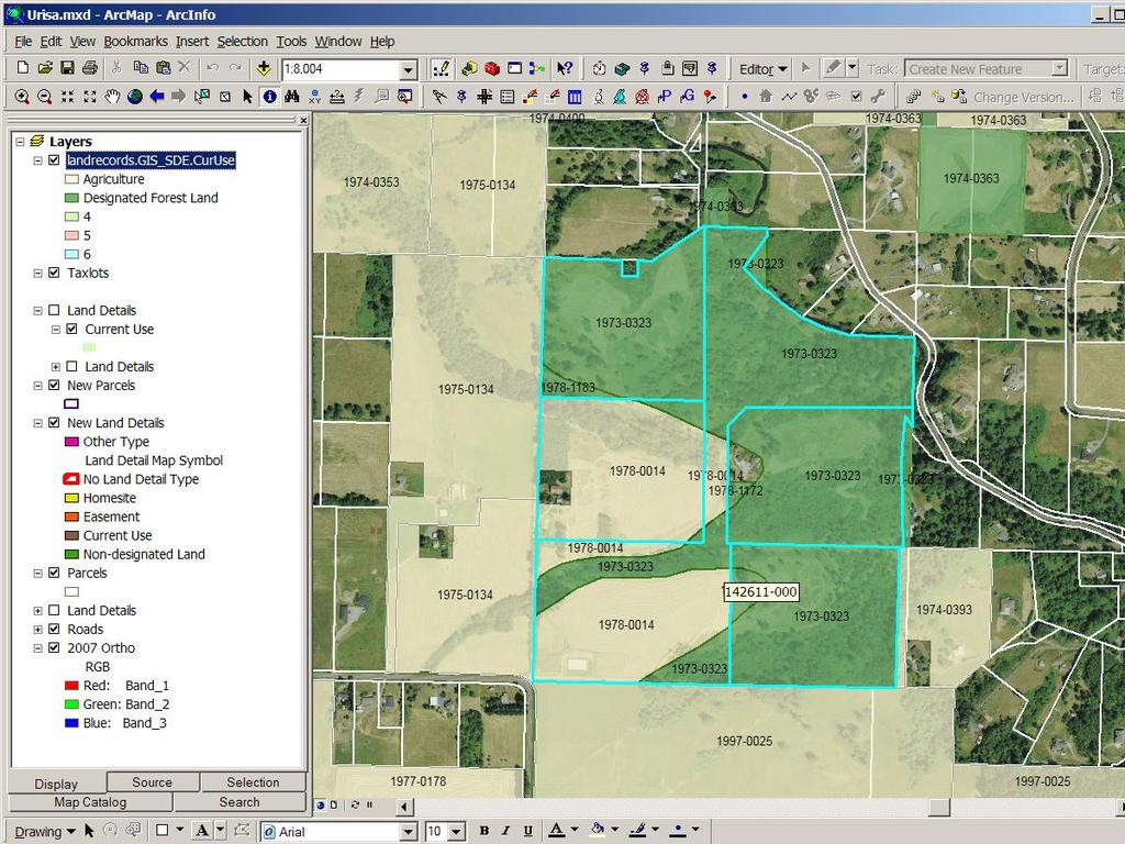
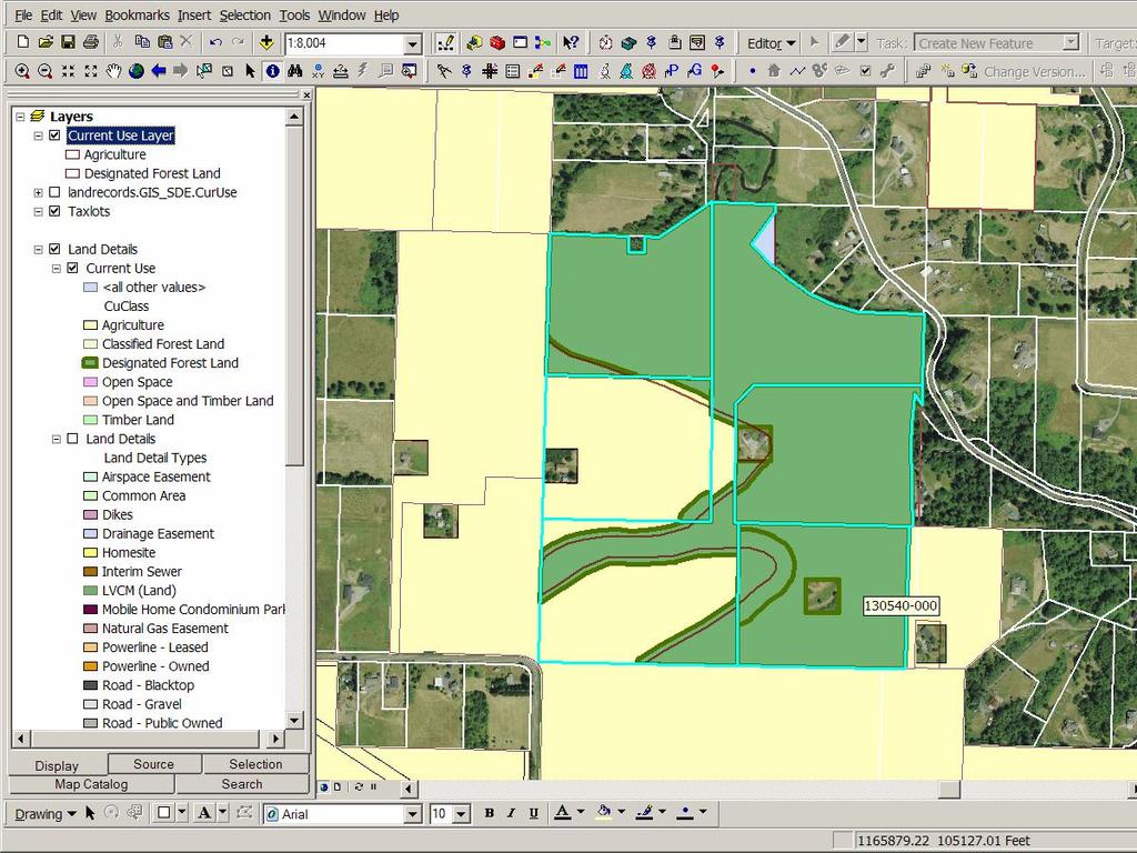
9 Land Detail Layer Sample Parcel

10 Mapping in Assessor Acres Homesite Area: * = 43560

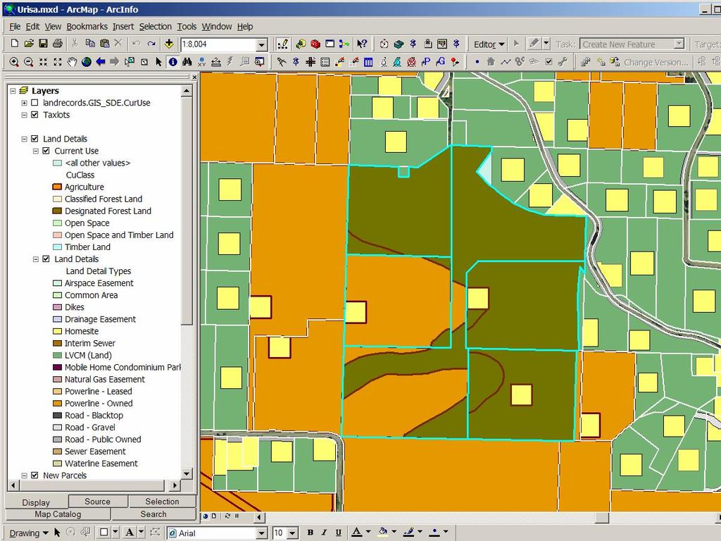
11 Land Detail Market Value Layer Based on: Slope, Wetlands, Easements, Homesite
12 Market Value Calculation GIS Acres * Factor * Market Value Type Rate Per Acre

13 Current Use Value Layer Based On Soil Types
14 Current Use Value Calculation GIS Area * Factor * Soil type Rate Per acre
15 Appraisers Role Interface between Policy and Public Did you take my wetland, cliff, easement into consideration?
16 Appraiser / Public Generalizations Slopes Includes Low or wetland Easements May not be a recorded easement. Areas Approximate but set in stone

17 Easements: Easements

18 Old School: 2 Sets of books Maintained Manually Totals Must Balance Easements, Wetlands deducted from Flat or Rolling
19 Mapping Benefits Easements No longer lost in the database Can visualize errors, inconsistencies No longer automatically deducted from high value land Slopes and Soils can use GIS Lidar Wetlands Inventory/Model
20 GIS Mapping Challenges How do you create polygons of a predefined size? Real Time Layer Maintenance In synch with Assessors Database Acreage adjustments Easement Add/Drops In synch with GIS Parcels Layer Parcel edits: Fitting new subdivisions In synch with Current Use Layer
21 Editing Land Details Place a seed feature: Point, Line, Poly Grow the feature to the correct size Adjust other features to accommodate the new polygon.
22 Homesite Seed

23 New 1 Acre Homesite

24 Easement Seed 2.5 Acre Easement
25 New Easement Homesite moved
26 Maintenance Parcel Splits and Merges Boundary Line Adjustments Assessor Acreage Correction Add, Drop, edit of easements
27 Requirements Keep layers in synch with Assessor database Keep Assessor database in synch with layers Keep it simple
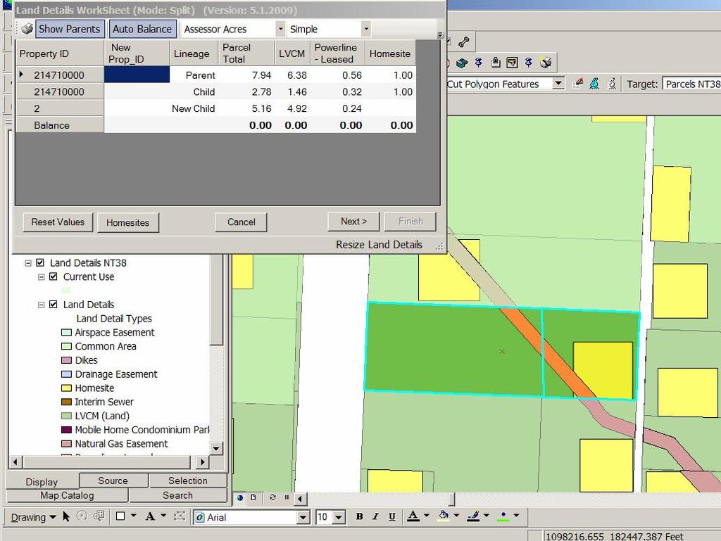
28 Land Detail Worksheet

29 Assessor Database GIS Layer
30


31
32 Split Merge
33

34
35
36 LandDetail Wizard Summary Spreadsheet / Wizard interface Automatically applies most changes to map layers Updates GIS Layers Land Detail Land Detail Market Value Current Use Value Updates Assessor s Database
37 Current Use Mapping based on tree lines, fields Acreage based on application Applications persist when parcels are split One Parcel can have multiple applications One Application can include multiple parcels
38
39
40
41 Conclusions Mapping by area is pretty cool Presents new ways of viewing information Simplifies, standardizes, automates many Assessment tasks Bridges the gap between legal areas and GIS based areas
GOVERNMENT. Case Study Ville de Trois Rivières streamlines property assessment
 GOVERNMENT Case Study Ville de Trois Rivières streamlines property assessment GIS-generated parcel basemap provides powerful visualization & analysis capabilities With a population of just over 130,000,
Town of Gilford, New Hampshire
 Town of Gilford, New Hampshire Technical Report: Build-Out Analysis Prepared by: Lakes Region Planning Commission 3 Main Street, Suite 3 Meredith, NH 03253 August 2003 Funding for this report was provided,
Using GIS To Manage Surface Ownership and Right-Of-Way
 Using GIS To Manage Surface Ownership and Right-Of-Way Jeff Bute - Sr. Land Maintenance Rep. / GIS Analyst Jeff was formerly a Property Tax Right of Way and Claims field agent for the company. Now he uses
Capturing the Geographic Value of Living in 3-D3. Boulder County Assessor s s Office
 Capturing the Geographic Value of Living in 3-D3 Boulder County Assessor s s Office Introduction 2 In the city of Boulder, 25 of 37 plats in 2007 were for condos Condominiums are popping up all over Boulder
2018 Assessment Roll Edit Guide for Parcel-Level Geographical Information System (GIS) Information
 Information") 2018 Assessment Roll Edit Guide for Parcel-Level Geographical Information System (GIS) Information Florida Department of Revenue Property Tax Oversight January 2, 2018 Intended Users This edit guide is
2018 Assessment Roll Edit Guide for Parcel-Level Geographical Information System (GIS) Information Florida Department of Revenue Property Tax Oversight January 2, 2018 Intended Users This edit guide is
Assessor. Mission Statement: Functions: Long Term Goals: Page 1 of 6
 Assessor Mission Statement: The mission of the Assessor s Office is to create accurate, equitable, and timely property tax assessments to fund public services; and to be a source of current, accurate property
A CADASTRAL GEODATA BASE FOR LAND ADMINISTRATION USING ARCGIS CADASTRAL FABRIC MODEL A CASE STUDY OF UWANI ENUGU, ENUGU STATE, NIGERIA
 A CADASTRAL GEODATA BASE FOR LAND ADMINISTRATION USING ARCGIS CADASTRAL FABRIC MODEL A CASE STUDY OF UWANI ENUGU, ENUGU STATE, NIGERIA BY Ndukwu, Raphael. Ike Department of Geoinformatics & Surveying University
ASSESSOR'S OFFICE I. DEPARTMENT MISSION OR MANDATE OR GOAL
 ASSESSOR'S OFFICE I. DEPARTMENT MISSION OR MANDATE OR GOAL The purpose of the Assessor's Office is to produce a timely roll of all property subject to local assessment; administer legally permissible exemptions;
Reassessment / GIS Project
 Reassessment / GIS Project Harry D. Lindsay, Director Department of Planning & Economic Development June 12, 2008 Background History Project initiated in 2001 Existing parcel maps vs. digital parcel maps
LRIMS Cadastre Module
 LRIMS Cadastre Module User Requirements and Functionality (Seychelles Case Study) John Latham, NRL Renato Cumani, NRL Luigi Simeone, NRL Summary Background User Requirements Business Model Application
Cadastral Survey in the 21 st Century. Gavin Adlington. Land Program Team Leader Europe and Central Asia Region (ECA)
") E-learning Series Cadastral Survey in the 21 st Century June 3, 2010 Gavin Adlington. Land Program Team Leader Europe and Central Asia Region (ECA) The World Bank Content : Purpose of cadastral survey
E-learning Series Cadastral Survey in the 21 st Century June 3, 2010 Gavin Adlington. Land Program Team Leader Europe and Central Asia Region (ECA) The World Bank Content : Purpose of cadastral survey
May 09, Tim Kerr, General Manager American River Flood Control District 185 Commerce Circle Sacramento, CA 95815
 May 09, 2018 Tim Kerr, General Manager American River Flood Control District 185 Commerce Circle Sacramento, CA 95815 Subject: ARFCD Assessment District Support Services Dear Tim: WSP USA Inc. (WSP) is
Homeowner s Exemption (HOE)
") Homeowner s Exemption (HOE) Table of Contents CHEAT SHEETS... 3 Add HOE to a Parcel...3 Edit HOE Record...3 Remove HOE from a Parcel...3 Find the HOE Amount...3 Who is getting the exemption?...4 New Application
Homeowner s Exemption (HOE) Table of Contents CHEAT SHEETS... 3 Add HOE to a Parcel...3 Edit HOE Record...3 Remove HOE from a Parcel...3 Find the HOE Amount...3 Who is getting the exemption?...4 New Application
Presented by: Stewart Information International, Inc. Jack McKenna
 Presented by: Stewart Information International, Inc. Jack McKenna Held at the: 2007 ESRI Survey & Engineering GIS Summit San Diego Convention Center San Diego, California June 16-19, 2007 Integrating
Reports. Martin Barrett Software Developer 8 Years
 Reports Martin Barrett Software Developer 8 Years 4-19-17 Vanguard Appraisals, Inc. Copyright 2017 Report Changes About me Report Changes New Reports Easy Mode Important Reminders Report Errors Explained
BUILD-OUT ANALYSIS GRANTHAM, NEW HAMPSHIRE
 BUILD-OUT ANALYSIS GRANTHAM, NEW HAMPSHIRE A Determination of the Maximum Amount of Future Residential Development Possible Under Current Land Use Regulations Prepared for the Town of Grantham by Upper
Regression + For Real Estate Professionals with Market Conditions Module
 USER MANUAL 1 Automated Valuation Technologies, Inc. Regression + For Real Estate Professionals with Market Conditions Module This Regression + software program and this user s manual have been created
Cloud GIS Real Estate Management, Appraisal and Development Service USING ESRIs ARCGIS SERVER
 Cloud GIS Real Estate Management, Appraisal and Development Service USING ESRIs ARCGIS SERVER INFODIM: Was founded on 1992 and is internationally certified as a GIS company from D&B Dun & Bradstreet Global
The TAUREAN Residential Valuation System An Overview
 The TAUREAN Residential Valuation System An Overview By Michael L. Robbins, Ph.D., CRE Taurean Residential Valuation Services, LLC 150 N. Sunny Slope Road, Suite 225, Brookfield, WI 53005 Phone: (262)
RPSV4 Users ORPTS Regional Directors and Managers ORPTS Customer Relationship Managers ORPTS Regional V4 Support Staff
 TO: FROM: RPSV4 Users ORPTS Regional Directors and Managers ORPTS Customer Relationship Managers ORPTS Regional V4 Support Staff Michael Griffen, RPS Support Group DATE: December 5 2016 SUBJECT: RPSV4
The New Technology of a Survey Data Model and Cadastral Fabric as the Foundation for a Future Land Administration System.
 The New Technology of a Survey Data Model and Cadastral Fabric as the Foundation for a Future Land Ian HARPER, Australia Key words: cadastral modelling, survey data model, Survey Accuracy, Cadastre 2014
GIS Based Tools for County Road Management Right-of-Way Land Value Analysis. January 12, 2012
 GIS Based Tools for County Road Management Right-of-Way Land Value Analysis January 12, 2012 Reasons for Needing Accurate Land Values Asset Management 1999 GASB Statement 34 Corridor Studies Scoping Studies
The Development of the Austrian Cadastre from Documentation to an Integrated Planning and Decision Support System
 The Development of the Austrian Cadastre from Documentation to an Integrated Planning and Decision Support System WPLA - Working Party on Land Administration 15-17 October 2014, Vienna, Austria Wernher
Egyptian Nationwide Title Cadastre System
 Kholoud SAAD, Egypt Key words: Cadastre, Registration, Urban, Rural, National Cadastre, Automation, reengineering. SUMMARY With growing need for integrated information, Enterprise Solutions has become
A. K. Alexandridis University of Kent. D. Karlis Athens University of Economics and Business. D. Papastamos Eurobank Property Services S.A.
 Real Estate Valuation And Forecasting In Nonhomogeneous Markets: A Case Study In Greece During The Financial Crisis A. K. Alexandridis University of Kent D. Karlis Athens University of Economics and Business.
GIS and Land Records Integration A PRIA White Paper
 110 Horizon Drive, Suite 210, Raleigh, NC 27615 919.459.2081 GIS and Land Records Integration A PRIA White Paper Adopted by the PRIA Board on December 20, 2017 www.pria.us/ GIS and Land Records Integration
 OnPoint Search Result http://gis1.hallcounty.org/public/webpages/map/mapviewer.aspx Map Tools Search Base Map Zoning Utilities Fire Services Law Enf Elections Pictometry Parcel / Owner Search Address Search
RAINS COUNTY APPRAISAL DISTRICT
 RAINS COUNTY APPRAISAL DISTRICT 2017 MASS APPRAISAL SUMMARY REPORT mass appraisal report 2017 uspap_appr_report RAINS COUNTY APPRAISAL DISTRICT 2017 MASS APPRAISAL SUMMARY REPORT Identification of Subject:
Automated Land Development Applications
 Automated Land Development Applications AGENDA Yarra Valley Water Land Development Process GIS Automation Business Rules Engine Automated Spatial Analysis Questions.Encourage GIS community to embrace GIS
A Vision for a Fully Digital Cadastral Survey System
 A Vision for a Fully Digital Cadastral Survey System Anselm HAANEN, Trent GULLIVER, New Zealand Key words: cadastral survey system, digital cadastre, survey plans SUMMARY Surveyors have traditionally prepared
Integrating SAS and Geographic Information Systems for Regional Land Use Planning
 Integrating SAS and Geographic Information Systems for Regional Land Use Planning ABSTRACT Bill Bass, Houston-Galveston Area Council, Houston, Tx The Houston-Galveston Area Council (H-GAC) provides regional
Issues in Wetland Protection
 This document is made available electronically by the Minnesota Legislative Reference Library as part of an ongoing digital archiving project. http://www.leg.state.mn.us/lrl/lrl.asp John Helland, Legislative
Topographic Signs Important Context of 3D Cadastre
 STATE GEODETIC ADMINISTRATION Gruška 20,10 000 Zagreb, Croatia Delft University of Technology Faculty of Architecture and the Built Environment Department OTB GIS Technology Section Topographic Signs Important
PREPARING SURVEY TENDER GIS DATABASE OUTCOMES
 PREPARING SURVEY TENDER SPECIFICATIONS FOR PROJECT GIS DATABASE OUTCOMES Presentation by Ian Harper GEODATA AUSTRALIA ESRI User Conference 2009 24 st July 2009 BACKGROUND GIS databases now provide a more
REFORM OF LAND CADASTRE IN LITHUANIA
 REFORM OF LAND CADASTRE IN LITHUANIA Romualdas KASPERAVICIUS, Lithuania Key words: ABSTRACT Main aim for every Government is to create legal, financial and organisational circumstances for real property.
Equalization Department
 Equalization Department Citizens Board of Commissioners Administrator /Controller Equalization Director Statutory Authority Michigan Compiled Law 211.34 (3) The County Board of Commissioners of a county
Arlington County, Virginia. Internal Audit of the Real Estate Assessment Appeals Process Calendar Year Ended December 31, 2014
 Arlington County, Virginia Internal Audit of the Real Estate Assessment Appeals Process Calendar Year Ended December 31, 2014 Table of Contents Transmittal Letter... 1 Executive Summary... 2-9 Background...
A LOOK AT REASSESSMENT FOR REHOBOTH BEACH. May 7, 2012
 A LOOK AT REASSESSMENT FOR REHOBOTH BEACH May 7, 2012 APPLICABLE LAW State of Delaware Constitution ARTICLE. VIII REVENUE AND TAXATION 1. Uniformity of taxes; collection under general laws; exemption for
User Manual. Section 2: Implementation and Industry Translations. Created: October Copyright PropertyBoss Solutions, LLC. All Rights Reserved.
 User Manual Section 2: Implementation and Industry Translations Created: October 2010 Copyright PropertyBoss Solutions, LLC. All Rights Reserved. PropertyBoss Manual Section 2 - Implementation and Industry
Configuring Service Charge Settlement in Flexible Real Estate Management (RE FX)
") Configuring Service Charge Settlement in Flexible Real Estate Management (RE FX) Applies to: Any consultant who wants to configure the Service Charge Settlement settings for user requirements in SAP flexible
Configuring Service Charge Settlement in Flexible Real Estate Management (RE FX) Applies to: Any consultant who wants to configure the Service Charge Settlement settings for user requirements in SAP flexible
Map Modernization Modernization Program
 FEMA Map Modernization Program Presented to Maryland Association of Floodplain and Stormwater Managers October 27, 2005 Map Modernization Program Autorun.exe 2 Map Modernization Program Outline Map Mod
New Models for Property Data Verification and Valuation
 New Models for Property Data Verification and Valuation for 2006 IAAO Councils and Sections Joint Seminar May 9-11, 2006 Charleston, South Carolina Presented by George Donatello, CMS Principal Consultant
CLINTON COUNTY AGRICULTURAL LAND PRESERVATION BOARD Agricultural Conservation Easement Application Form
 CLINTON COUNTY AGRICULTURAL LAND PRESERVATION BOARD Agricultural Conservation Easement Application Form A separate application shall be required for each farmland tract offered for easement purchase. The
Phase I Environmental Site Assessments for Corridors
 Phase I Environmental Site Assessments for Corridors Prepared by: Kimberly Perkins and Jill Biesma 1 Environmental Advisors and Engineers 19211 W. 64 th Terrace, Shawnee, KS 66218 (913) 599-4326 Goal Of
BOROUGH OF ISLAND HEIGHTS OCEAN COUNTY NEW JERSEY PROFESSIONAL SERVICES SOLICITATION
 BOROUGH OF ISLAND HEIGHTS OCEAN COUNTY NEW JERSEY PROFESSIONAL SERVICES SOLICITATION PROFESSIONAL SERVICES: PROPOSAL FOR REASSESSMENT AND/OR REVALUATION OF ALL PROPERTY IN THE BOROUGH OF ISLAND HEIGHTS
ARTICLE 5 MINOR SUBDIVISION/LAND DEVELOPMENT
 ARTICLE 5 MINOR SUBDIVISION/LAND DEVELOPMENT SECTION 501 ONLY FINAL PLAN REQUIRED The classification of a proposed subdivision as a "Minor Subdivision" shall only require the submission, review and approval
LLANO COUNTY, TEXAS. Closed and Abandoned Landfill Inventory UPDATE
 LLANO COUNTY, TEXAS Closed and Abandoned Landfill Inventory UPDATE Prepared by the: Capital Area Council of Governments 2010 CLOSED LANDFILL INVENTORY BASIC IDENTIFYING INFORMATION A. COG Name: Capital
Return on Investment Model
 THOMAS JEFFERSON PLANNING DISTRICT COMMISSION Return on Investment Model Last Updated 7/11/2013 The Thomas Jefferson Planning District Commission developed a Return on Investment model that calculates
Opening: GIS Specialist and Real Property Lister Department: Land Management
 Opening: GIS Specialist and Real Property Lister Department: Land Management Trempealeau County Human Resource Department 36245 Main St., PO Box 67, Whitehall, WI 54773 715-538-2311 ext 224 personnel@tremplocounty.com
Development and Updates of Protected Lands Databases in the US (PAD-US, NCED, CARL)
") Development and Updates of Protected Lands Databases in the US (PAD-US, NCED, CARL) Robb Macleod, National GIS Coordinator at Ducks Unlimited rmacleod@ducks.org 734-623-2004 Overview 1. What is the NCED,
Development and Updates of Protected Lands Databases in the US (PAD-US, NCED, CARL) Robb Macleod, National GIS Coordinator at Ducks Unlimited rmacleod@ducks.org 734-623-2004 Overview 1. What is the NCED,
An Alternate Approach to Address Creation and Maintenance Hernando County Property Appraiser Alvin R. Mazourek, CFA
 An Alternate Approach to Address Creation and Maintenance Hernando County Property Appraiser Alvin R. Mazourek, CFA Presenters: Neil F. Nick Nikkinen, CFE Manuel J. Padrón Hernando County, Florida Statistics:
PITKIN COUNTY S TDR PROGRAM
 PITKIN COUNTY S TDR PROGRAM In 1987, when Pitkin County completed the Down Valley Comprehensive Plan, we did not envision the type of accelerated, large-scale development pressures that we would experience
The Newsletter of the Maine Chapter IAAO SPRING Covering Maine Assessing FROM THE EDITOR:
 Covering Maine Assessing The Newsletter of the Maine Chapter IAAO SPRING 2013 FROM THE EDITOR: Maine chapter iaao SPRING 2013 By Kyle Avila, CMA I use GIS daily for explaining valuations to taxpayers in
QUESTIONNAIRE. 1. Authorizing statute(s) citation West Virginia Code and 11-1C-4(d)
 citation West Virginia Code and 11-1C-4(d)") QUESTIONNAIRE (Please include a copy of this form with each filing of your rule: Notice of Public Hearing or Comment Period; Proposed Rule, and if needed, Emergency and Modified Rule.) DATE: 6/8/15 TO:
QUESTIONNAIRE (Please include a copy of this form with each filing of your rule: Notice of Public Hearing or Comment Period; Proposed Rule, and if needed, Emergency and Modified Rule.) DATE: 6/8/15 TO:
Directorate of Survey and Mapping NAMIBIA. Cadastral Information System. Vehupisa Kasuko Tjatindi Surveyor Directorate of Survey and Mapping NAMIBIA
 Vehupisa Kasuko Tjatindi Directorate of Survey and Mapping NAMIBIA Tel: +64 61 965000 Directorate of Survey and Mapping NAMIBIA Cadastral Information System Introduction Over the past few decades cadastral
Appraiser II or Appraiser III / Tax Assessor's Office
 UNIFIED GOVERNMENT OF ATHENS-CLARKE COUNTY invites applications for the position of: Appraiser II or Appraiser III / Tax Assessor's Office SALARY: $38,348.00 - $55,813.00 Annually OPENING DATE: 09/21/18
How a Cadaster Might Look Like in Finland in the Year 2035?
 How a Cadaster Might Look Like in Finland in the Year 2035? Mr. MARKKU Eino Olavi MARKKULA, Finland Key words; Cadastre, Coordinates, Digitised Process, Key Registers, Land Register Summary The Finnish
TROUBLESHOOTING YOUR CAMA DATA WITH GIS
 Chad Rupert Office of Information Technology Outreach Services (ITOS) University of Georgia Athens, GA 30602-5418 Ph: 706-542-5308 Email: rupert@itos.uga.edu Jimmy Nolan Office of Information Technology
McLennan County Appraisal District Annual Report. MCAD Waco, TX. 1 P age
 McLennan County Appraisal District Waco, TX Administration Annual Report McLennan County Appraisal District 2016 Annual Report MCAD Waco, TX 1 P age Appraisal District Overview The McLennan County Appraisal
ORDINANCE NO AN ORDINANCE ESTABLISHING A UNIFORM SYSTEM FOR STREET ADDRESSING IN EMERY COUNTY
 ORDINANCE NO. 21505 AN ORDINANCE ESTABLISHING A UNIFORM SYSTEM FOR STREET ADDRESSING IN EMERY COUNTY The County Commission of the County of Emery, State of Utah, being the Legislative Body of said county,
METHODOLOGY GUIDE VALUING MOTELS IN ONTARIO. Valuation Date: January 1, 2016
 METHODOLOGY GUIDE VALUING MOTELS IN ONTARIO Valuation Date: January 1, 2016 AUGUST 2016 August 22, 2016 The Municipal Property Assessment Corporation (MPAC) is responsible for accurately assessing and
A guide to the let only scheme
 Who should read this? Key Documents Tenants Agents Landlords A guide to the let only scheme A guide to the let only scheme Why let only? Following consultation, members told us that they wanted TDS to
ParcelMap BC Compiling a Parcel Fabric for the Province of British Columbia. Presented by: Ellen Styner (General Manager) and Wendy Amy (GIS Manager)
 and Wendy Amy (GIS Manager)") ParcelMap BC Compiling a Parcel Fabric for the Province of British Columbia Presented by: Ellen Styner (General Manager) and Wendy Amy (GIS Manager) Who is MNC? MNC is a geomatics engineering firm with
ParcelMap BC Compiling a Parcel Fabric for the Province of British Columbia Presented by: Ellen Styner (General Manager) and Wendy Amy (GIS Manager) Who is MNC? MNC is a geomatics engineering firm with
STONE COUNTY PRELIMINARY PLAT CHECKLIST. Note: Applications need to be in the office by 2 p.m. on the cutoff day.
 STONE COUNTY PRELIMINARY PLAT CHECKLIST Note: Applications need to be in the office by 2 p.m. on the cutoff day. JOY WILSON, DIRECTOR Return form to: Planning & Zoning Administrator PO Box 301, Galena,
5. PROPERTY VALUES. In this section, we focus on the economic impact that AMDimpaired
 5. PROPERTY VALUES In this section, we focus on the economic impact that AMDimpaired streams have on residential property prices. AMD lends itself particularly well to property value analysis because its
Essential Skills Wales Essential Application of Number Skills (EAoNS) Level 3 Controlled Task Candidate Pack
 Level 3 Controlled Task Candidate Pack") Essential Skills Wales Essential Application of Number Skills (EAoNS) Level 3 Controlled Task Candidate Pack Investigating Accommodation Options Sample 1 Candidate name: Candidate number: Date registered
Essential Skills Wales Essential Application of Number Skills (EAoNS) Level 3 Controlled Task Candidate Pack Investigating Accommodation Options Sample 1 Candidate name: Candidate number: Date registered
GIS After the Conversion. Mid West ESRI Utility Users Group 2007
 GIS After the Conversion Mid West ESRI Utility Users Group 2007 Presented by: A Jeffrey A. Grussing Leader, GIS Development jgrussing@usgweb.com Background Kandiyohi Power Cooperative Worked two years
REQUEST FOR PROPOSALS 2017 TOWN-WIDE REAPPRAISAL
 REQUEST FOR PROPOSALS FOR 2017 TOWN-WIDE REAPPRAISAL ISSUED BY TOWN OF HARTFORD 171 Bridge Street White River Jct., VT 05001 Date of Issuance: October 1, 2015 Response Deadline: October 30, 2015 2 TOWN
BOARD OF REVIEW SCRIPT
 BOARD OF REVIEW SCRIPT CLERK'S SCRIPT: 1. Clerk introduces the case by stating the following information: a. Tax Key # b. Property address c. Property Owner d. Mailing address if different. e. Class of
Office of the City Auditor. Audit of the Office of the Real Estate Assessor
 Report Date: August 28, 2015 Office of the City Auditor 2401 Courthouse Drive, Room 344 Virginia Beach, Virginia 23456 757.385.5870 Promoting Accountability and Integrity in City Operations Contact Information
GIS & Mobile Technology: It s Not Just For Real Property Tangible Technology for Tangible Personal Property Valuation
 GIS & Mobile Technology: It s Not Just For Real Property Tangible Technology for Tangible Personal Property Valuation Steve Weissman, RES, CFE, MBA Manager, Personal Property Appraisal Section Palm Beach
Municipal Assessment Values vs. Sales Data
 Municipal Assessment Values vs. Sales Data A means of determining equity in the property tax system Karl Green Department of Community Development Why study assessed values? Not often well understood or
2017 SOLGM Conference VALUATION ISSUES
 2017 SOLGM Conference VALUATION ISSUES Neill Sullivan, Valuer-General Land Information New Zealand 9 October 2017 Introduction The market has been on fire!- big increases across NZ in 2016! The Market
The Ranches Sketch Plan
 The Ranches Sketch Plan APPLICATION: RURAL LAND USE PROCESS (AKA CLUSTER DEVELOPMENT) HEARING DATES: Planning Commission: 12 July 2017 at 6:30 pm Board of County Commissioners: TBD APPLICANT: REQUEST:
presentation for October 5, 2018
 presentation for October 5, 2018 Proper Lease Analysis + Proper Technology = Successful Implementation Designed by Former Big 4 Auditors Built for Audit Efficiency Key Design Principles Ease of Use & Security
An Approach to Integration of Land Administration System
 An Approach to Integration of Land Administration System, Republic of Korea Key words: Land Administration System, Integration, South Korea SUMMARY Korea s modern land system was enforced after the land
YOUNG COUNTY APPRAISAL DISTRICT
 YOUNG COUNTY APPRAISAL DISTRICT 2017 - ANNUAL APPRAISAL REPORT AS OF 10/6/2017 1 2 TABLE OF CONTENTS ITEM PAGE Introduction 4 Purpose of Report...4 Taxing Entities, Rates & Exemptions 5 Property Types
PILT Report to the Legislature Minn. Laws 1st Special Session, ch. 2, art. 4, sec. 35
 PILT Report to the Legislature 2011 Minn. Laws 1st Special Session, ch. 2, art. 4, sec. 35 Legislative Charge By December 1, 2012, the commissioner of natural resources, in cooperation with the commissioners
The GIS Behind Dakota County s FARMLAND AND NATURAL AREAS PROGRAM
 The GIS Behind Dakota County s FARMLAND AND NATURAL AREAS PROGRAM The Farmland and Natural Areas Program is a voluntary program in which Dakota County and other partners work with willing landowners to
Accounts in Brazoria County have two primary Identification numbers. The two forms of Identification are as follows:
 Accounts in Brazoria County have two primary Identification numbers. The two forms of Identification are as follows: Property ID: This is a six digit number that is generated sequentially as accounts are
CITY UTILITIES DESIGN STANDARDS MANUAL
 CITY UTILITIES DESIGN STANDARDS MANUAL () September 2017 Page Chapter 1 Acronyms and Definitions 1.01 Purpose 1 1.02 Acronyms 1 1.03 Definitions 2 Chapter 2 Introduction 02.01 Purpose 1 2.02 City Utilities
Quality Improvement to Cadastral Information in Sweden
 Gunnar BLIXT, Sweden Key words: digital cadastre, quality, cadastral index map, real property register. SUMMARY Lantmäteriet is a governmental agency which gives support for creating an efficient and sustainable
*Predicted median absolute deviation of a CASA value estimate from the sale price
 PLATINUMdata Premier AVM Products ACA The AVM offers lenders a concise one-page summary of a property s current estimated value, complete with five recent comparable sales, neighborhood value data, homeowner
Easements, Establishments, Abandonments and Vacations
 Easements, Establishments, Abandonments and Vacations A highway easement conveys, in perpetuity, the right to construct and maintain a highway facility on the land of the fee holder. (Property owner) The
2013 Project Abstract For the Period Ending June 30, 2015
 2013 Project Abstract For the Period Ending June 30, 2015 PROJECT TITLE: Conservation Easement Stewardship Program, Phase III PROJECT MANAGER: Don Kilberg AFFILIATION: Minnesota Department of Natural Resources
CHARTER TOWNSHIP OF LYON APPLICATION FOR LAND DIVISION (LOT SPLIT)
") File #: Date Submitted: CHARTER TOWNSHIP OF LYON APPLICATION FOR LAND DIVISION (LOT SPLIT) NOTICE TO APPLICANT: Applications for land divisions (also called lot splits ) are reviewed in accordance with
File #: Date Submitted: CHARTER TOWNSHIP OF LYON APPLICATION FOR LAND DIVISION (LOT SPLIT) NOTICE TO APPLICANT: Applications for land divisions (also called lot splits ) are reviewed in accordance with
Universal Geo-database Connector Interface Component (UG-CIC) For Virtual Web-base GIS Server Essential For Real Estate Industry Uses
 For Virtual Web-base GIS Server Essential For Real Estate Industry Uses") Universal Geo-database Connector Interface Component (UG-CIC) For Virtual Web-base GIS Server Essential For Real Estate Industry Uses Jad Jarroush & Dr. Kobi Zaid Zaid Orniv Group L.T.D Israel kobi_z@zaidorniv.co.il
Universal Geo-database Connector Interface Component (UG-CIC) For Virtual Web-base GIS Server Essential For Real Estate Industry Uses Jad Jarroush & Dr. Kobi Zaid Zaid Orniv Group L.T.D Israel kobi_z@zaidorniv.co.il
COUNTY COUNCIL OF PRINCE GEORGE S COUNTY, MARYLAND, SITTING AS THE DISTRICT COUNCIL ORDER AFFIRMING PLANNING BOARD DECISION, WITH CONDITIONS
 Case No.: Applicant: SDP-0607 Acton Park, Inc. COUNTY COUNCIL OF PRINCE GEORGE S COUNTY, MARYLAND, SITTING AS THE DISTRICT COUNCIL ORDER AFFIRMING PLANNING BOARD DECISION, WITH CONDITIONS IT IS HEREBY
Sales Ratio: Alternative Calculation Methods
 For Discussion: Summary of proposals to amend State Board of Equalization sales ratio calculations June 3, 2010 One of the primary purposes of the sales ratio study is to measure how well assessors track
Equalization. Equalization. Statutory Duties. Statutory Authority
 Equalization Citizens Board of Commissioners Administrator /Controller Statutory Duties Advise and assist the Board of Commissioners in equalizing property tax assessments on a county-wide basis. File
MMSVP Migration Wizard
 MMSVP Migration Wizard Questions? From within BS&A, go to Help>Contact Customer Support and select Request Support Phone Call or Email Support. Or, you may call us at (855) 272-7638 and ask for the appropriate
Primary Discussion Topics
 Analysis of Retained and Assumable Waters in Minnesota A Supplement to the January 17, 2017 MN Federal Clean Water Act Section 404 Permit Program Feasibility Study Report to the Legislature February 7,
The Challenge to Implement International Cadastral Models Case Finland 1
 The Challenge to Implement International Cadastral Models Case Finland 1 Tarja MYLLYMÄKI and Tarja PYKÄLÄ, Finland Key words: cadastre, modelling, LADM, INSPIRE SUMMARY Efforts are currently made to develop
Tax Credit Management Abilities
 Web-Based, ASP Hosted, Enterprise Class Property Management Software Tax Credit Management Abilities Dear Property Manager, Property management software is becoming more and more complicated and loaded
Maximum Assessed and Assessed Value
 Chapter 13 Maximum Assessed and Assessed Value Maximum Assessed Value The assessor is required to calculate a maximum assessed value (MAV) for each property in the county in addition to maintaining real
Chesapeake Bay Program Indicator Analysis and Methods Document Protected Lands Updated September 2016 (Data current through 2015_16)
") 1 Chesapeake Bay Program Indicator Analysis and Methods Document Protected Lands Updated September 2016 (Data current through 2015_16) Indicator Title: Protected Lands Relevant Outcome(s): Protected Lands
1 Chesapeake Bay Program Indicator Analysis and Methods Document Protected Lands Updated September 2016 (Data current through 2015_16) Indicator Title: Protected Lands Relevant Outcome(s): Protected Lands
Development of e-land Administration in Sweden
 Development of e-land Administration in Sweden Roger EKMAN, Sweden Key words: e-land Administration, e-cadastre, delivery times, process development SUMMARY A characteristic of the Swedish cadastral procedure
CFPB Implementation of Parcels Provision in HMDA Under Dodd-Frank
 CFPB Implementation of Parcels Provision in HMDA Under Dodd-Frank Land ownership is the foundation of the financial, legal, and real estate systems in our society Parcel Data vs. Census Data + Census data
Office of Legislative Services Background Report The Assessment of Real Property: Answers to Frequently Asked Questions
 Office of Legislative Services Background Report The Assessment of Real Property: Answers to Frequently Asked Questions OLS Background Report No. 120 Prepared By: Local Government Date Prepared: New Jersey
Program Data Table Item 13. Adjusted Special Flood Hazard Area (asfha) GOAL:
 GOAL:") Community Rating System analysis procedure Wednesday, September 15, 2015 Prepared by Laura Gibson, reviewed by Mike Dumais and Beth Yang Program Data Table Item 13. Adjusted Special Flood Hazard Area (asfha)
Community Rating System analysis procedure Wednesday, September 15, 2015 Prepared by Laura Gibson, reviewed by Mike Dumais and Beth Yang Program Data Table Item 13. Adjusted Special Flood Hazard Area (asfha)