TOWN OF BROOKLINE, NEW HAMPSHIRE
|
|
|
- Shon Walsh
- 5 years ago
- Views:
Transcription

1 TOWN OF BROOKLINE, NEW HAMPSHIRE BUILDOUT ANALYSIS DECEMBER, 2003 Prepared by the Nashua Regional Planning Commission
2
3 TABLE OF CONTENTS Introduction... 1 I. Methodology... 1 A. PARCEL REVIEW... 1 B. DEVELOPMENT CONSTRAINTS... 1 C. DENSITY CALCULATIONS... 2 D. PARCEL SIZE RANGES AND BUILDOUT CALCULATIONS... 4 E. NON-RESIDENTIAL SQUARE FOOTAGE II. Results A. PARCELS BETWEEN ONE AND FIVE ACRES IN SIZE B. PARCELS BETWEEN FIVE AND TWENTY ACRES IN SIZE C. PARCELS GREATER THAN TWENTY ACRES IN SIZE D. ENTIRE TOWN/OVERALL RESULTS III. Analysis and Conclusions A. ESTIMATED TIME TO BUILDOUT B. BROOKLINE S FUTURE POPULATION C. POTENTIAL IMPACTS OF BUILDOUT ON BROOKLINE S CAPITAL FACILITIES AND MUNICIPAL SERVICES D. ADDRESSING THE IMPACTS OF DEVELOPMENT LIST OF TABLES AND MAPS Table 1. GIS Data Layers and Sources... 2 Table 2. Average Densities of Recently Approved Conventional Subdivisions... 3 Table 3. Average Densities of Recently Approved Open Space Development Subdivisions... 3 Map 1: Generalized Land Use in Brookline, Map 2: Vacant Parcels by Acreage Value... 8 Map 3: Environmental and Use Constraints Table 4. Parcels between one and five acres Table 5. Parcels between five and twenty acres in size Table 6. Parcels greater than twenty acres in size Table 7. Total Potential New Lots for Town of Brookline Map 4: Buildout Potential by Number of New Lots Table 8. Number of Dwelling Units and Target Number of Permits, Table 9. Estimated Number of dwelling Units and Population Change, 2000 Buildout Page i.
4
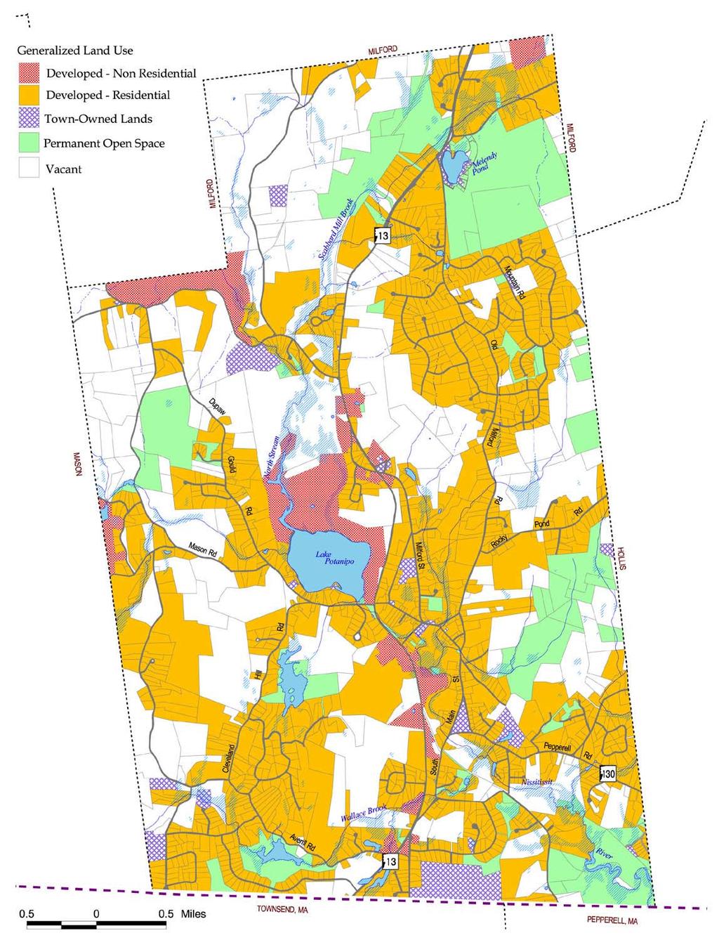
5 INTRODUCTION Upon request of the Brookline Planning Board, NRPC has prepared a Buildout Analysis for the Town of Brookline, NH. The study was funded by the NH Community Development Finance Authority (CDFA) in support of local economic development planning. The primary goal is to provide the Town and the public with information needed to make informed choices regarding the impact of future population growth. Data was assembled at the parcel level, but summarized as subsets for the entire community. The results can provide base data for the Town Facilities Committee and Capital Improvements Committee and other municipal boards and agencies. The information in the Buildout Study should also assist the Planning Board and Conservation Commission in their future planning efforts relative to land acquisition and Master Planning. This Buildout Study uses Geographic Information System software (GIS) to analyze parcel specific data for the Town of Brookline and produce the results in both table and map format. A GIS utilizes computerized mapping software that incorporates a relational database management system to organize information about geographic features. The Nashua Regional Planning Commission is continually improving and updating the GIS database for its member communities to incorporate ongoing land use and natural resource changes. I. METHODOLOGY A. Parcel Review The first step in the Brookline Buildout Analysis involved updating the local land use designations to accurately identify vacant and underdeveloped properties. In the local parcel database maintained by NRPC, all parcels were assigned one of five land use categories: Vacant, Undevelopable (roads, water), Open Space (Permanent Open Space or Town-Owned Lands), Developed Residential, or Developed Non- Residential. Map 1 displays the distribution of these land uses in Brookline. Properties considered Vacant, Developed Residential or Developed Non-Residential were examined to determine a set of parcels that would represent the net buildable area. A GIS database representing the Buildout Study area then selected all parcels coded as vacant, plus those coded as either developed category and in excess of five acres. Two zoning districts exist in Brookline, Residential/Agricultural and Industrial/Commercial. The residential district is designed to provide locations in Town that are predominantly residential, while also allowing agricultural uses that help preserve the Town s rural character. Single family and duplex units are allowed by right in the residential district. The industrial/commercial district encompasses most of Brookline s commercial and industrial land uses. Light industry, auto repair, restaurants and professional offices are some of the permitted land uses in this district. The study area parcels were combined with the local zoning datalayer to associate the appropriate zoning district with each parcel. B. Development Constraints Constraints mapping involves determining the net developable area of the study area parcels. For the purposes of this Buildout Study, net developable area in Brookline is defined as the proportion of a privately owned vacant or underdeveloped parcel that is not constrained by the following features: Areas containing an existing improvement or set aside as permanent open space Wetlands and the 50-foot wetland buffer zone Slopes in excess of 25% 100-year floodplain Page 1.
6 Table 1 describes the GIS datalayers that were combined to create a composite layer representing development constraints. These are presented graphically in Map 3. Table 1. GIS Data Layers and Sources Data Layer Source Description Floodplains FIRM Depicts Zone A (100-year) floodplains Landuse NRPC/Brookline Assessor Land use types by parcel derived from local Assessing values Parcels NRPC/Brookline Includes parcels boundaries, attributes Roads NH DOT Based on USGS Digital Line Graph Town Boundary NH GRANIT Based on USGS Digital Line Graph Water NH GRANIT Based on USGS Digital Line Graph Wetlands US Fish and Wildlife Service NWI Wetlands Zoning NRPC/Brookline Depicts all zoning districts Note: FIRM = Flood Insurance Rate Map; UNH = University of New Hampshire; NH DOT= NH Department of Transportation; NH GRANIT = New Hampshire Geographically Referenced Analysis and Information Transfer System C. Density Calculations The quantity of development in a Buildout Study is expressed as the number of potential new lots. This study makes the assumption that housing availability drives population growth. Thus, an accurate calculation of a realistic density factor is critical. As practiced in Brookline, two (2) residential development styles are presently allowed by the local zoning ordinance: Conventional and Open Space Subdivisions. As shown in Table 2, the average density of recently approved conventional subdivisions in Brookline is one unit per 3.02 acres. To arrive at this density factor, a survey of several recently approved subdivisions in Brookline was undertaken. First, the net buildable area is calculated by subtracting the total amount of constrained land (wetlands, floodplains, steep slopes) on a parcel being subdivided from the total area of the tract. This net developable area is then divided by the number of lots being created to arrive at the density factor. The density factor used in this Buildout Study is the average net density of several typical conventional subdivisions. The density factor is greater than the minimum permissible lot size of 80,000 square feet (about two acres) because the odd shape of many lots, together with the presence of wetlands and other constraints, results in a real world density less than the minimum lot size allows. This is especially true for small conventional subdivisions, which must use the existing frontage rather than frontage created to allow for new lots, as occurs with large subdivisions. The Brookline Zoning Ordinance anticipates that subdivisions on tracts greater than 20 acres will be developed as open space developments, where the overall density cannot exceed one unit per 80,000 square feet, but where individual lots can be reduced to a minimum of one acre. At least 35% of the total area being subdivided must be set aside as open space. Because this development style allows the developer to place house lots on the best (unconstrained) land, the net density of open space developments more closely approximates the minimum lot size required by zoning. The density factor for open space developments is derived in the same manner as for conventional subdivisions. It is important to note that the constrained land within the protected open space is considered when calculating the net developable area. Page 2.
7 Table 2. Average Densities of Recently Approved Conventional Subdivisions Subdivision Name Approval Date Net Buildable Area (acres)* Number of Lots Approved Density (acres per unit) Comeau Cadorette Bross David Farwell Gerald Farwell Axel Average Density 3.02 Source: Town of Brookline Planning Department. *Net Buildable Area = gross parcel area area of wetlands and floodplains. Table 3. Average Densities of Recently Approved Open Space Development Subdivisions Subdivision Name Approval Date Net Buildable Area (acres)* Number of Lots Approved Density (acres per unit) Beaver Woods Maplewood Estates Stonehouse Estates Castle Drive Glendale Average Density 2.39 Source: Town of Brookline Planning Department. *Net Buildable Area = gross parcel area area of wetlands and floodplains. Page 3.
8 D. Parcel Size Ranges and Buildout Calculations To accommodate the differing lot densities, NRPC stratified the developable parcels by lot size in order to determine the most likely development approach. Map 2 displays the distribution of vacant land by the parcel sizes a (less than five acres), b (five to twenty acres) and c (greater than twenty acres) as follows: a) Five (5) acres or less in size. Given that the average net density of conventional subdivisions is one home per 3.02 acres (see Table 2), only one home is assumed possible on vacant lots less than five acres. b) Greater than five (5) acres and less than twenty (20) acres. It is assumed that these parcels will be developed as conventional subdivisions in which the minimum lot size is one unit per 80,000 square feet (nearly two acres) with 200 feet of frontage. In actual practice, the net density of conventional subdivisions in this size range is one unit per 3.02 acres. c) Twenty (20) acres and greater. The Brookline zoning ordinance assumes that parcels twenty (20) acres and greater will be developed as open space developments. In actual practice, the average net density of open space subdivisions is one unit per 2.39 acres (see Table 3). The density of industrial/commercial development on vacant and subdividable land zoned for that purpose is one unit per acre, according to the requirements of the Brookline Zoning Ordinance. Most of the vacant land is found in parcels greater than twenty acres, with most of these located west of Route 13. The vacant land between five and twenty acres is more evenly distributed throughout the Town. The vacant parcels less than five acres are also widely distributed. Page 4.
9 Map 1: Generalized Land Use in Brookline, 2003 Page 5.
10 Page 6.
11 Page 7.
12 Map 2: Vacant Parcels by Acreage Value Page 8.
13 Page 9.
14 Page 10.
15 Parcels that were considered underdeveloped are those currently in some form of active use and greater than five acres in size. Given the current required minimum lot sizes in Brookline (two acres in the Residential-Agricultural district, one acre in the Industrial-Commercial district), these could conceivably be subdivided into several new lots. For parcels in the Residential-Agricultural district, two acres was subtracted from the total developable area in order to accommodate a legal lot for the existing structure. In the B zone, 1 acre was subtracted. The remaining acreage is then considered subdividable. In addition to the above-mentioned constraints, the parcel currently occupied by Camp Tevya (Tax map E Lot 15), just north of Lake Potanipo, was removed from this analysis. The Camp property consists of approximately two hundred thirty acres, and though not currently protected, the Planning Board noted that it was unlikely development would occur on the site given the Community s interest in the property. Finally, vacant lots less than one acre in size were also removed from the Buildout Study. Given that the Brookline Zoning Ordinance requires a two acre minimum lot size, these parcels were considered substandard and thus no future development is anticipated for these parcels. Page 11.

16 Map 3: Environmental and Use Constraints Page 12.
17 E. Non-Residential Square Footage To calculate the potential future amount of commercial and industrial space, a survey of all lots in the Industrial/Commercial zoning district was undertaken. The average square feet of commercial or industrial space on these lots was found to be 5,776 square feet. That number was then multiplied by the number of new industrial/commercial lots being created to obtain the total number of potential industrial and commercial space at buildout. II. RESULTS Results of the Buildout Study were calculated and summarized for parcels in each size range according to whether they are zoned Residential/Agricultural (R) or Industrial/Commercial (I/C) and additionally for the entire town. Tables 4, 5 and 6 summarize the potential number of new residential and industrial/commercial lots for the study area by Zoning district. The two zoning districts are treated separately because of their different minimum lots size requirements; one acre for industrial/commercial and approximately two acres for residential. A. Parcels between one and five acres in size As indicated in Table 4, there are 40 vacant parcels between one and five acres that are zoned residential in Brookline. These 40 parcels total acres, of which 16.8 acres are constrained (wetlands, steep slopes and floodplains, 10% for roads), leaving 86.6 net developable acres. Applying a density of one lot per 3.0 acres results in an estimate of 29 potential new lots on parcels between one and five acres in size. There are 4 vacant parcels between one and five acres that are zoned industrial/commercial. These parcels total 10.6 acres, of which 1.5 acres are constrained, resulting in a net developable area of 9.1 acres. The potential Buildout of industrial/commercial lots for parent parcels of less than 5 acres is therefore 9 new lots. Table 4. Parcels between one and five acres Development Status Zoning # of Parcels Total Parcel Acres Constrained Land (acres) Net Developable Area Lot Density Factor Potential New Lots Vacant R I/C DEV R NONRES I/C DEV R RES I/C Totals R I/C Page 13.
18 B. Parcels between five and twenty acres in size There are 84 vacant parcels, one (1) non-residential parcel and 128 developed but subdividable parcels, for a total of 213 parcels zoned for residential use in Brookline. Looking at the totals row at the bottom, it can be seen that these 213 parcels account for 2,036 acres, of which 258 acres are built upon and acres are constrained, leaving a net developable area of 1,281.2 acres. Since subdivisions for this size range of parent parcel will be conventional subdivisions, that number is then divided by three (3) to arrive at the potential number of new lots. For land zoned industrial/commercial, there are 3 vacant parcels, 6 parcels developed with a nonresidential use and 0 lots developed with a residential use, for a total of 9 parent parcels between 5 and 20 acres. These 9 parcels represent 81.6 acres, of which 6 acres are built upon and 15.3 acres are constrained, leaving a net developable area of 60.3 acres. Applying a density factor of one lot per acre, there are a total of 60 potential new commercial/industrial lots on parent parcels between five and twenty acres in size. Development Status Zoning Table 5. Parcels between five and twenty acres in size # of Parcels Total Parcel Acres Built Upon Acres Constrained Land (acres) Net Developable Area Lot Density Potential New Lots Vacant R I/C DEV R NON RES I/C DEV R , RES I/C Totals R , , I/C C. Parcels greater than twenty acres in size The last category of residentially-zoned parcels to be considered are those over twenty acres in size. The residentially-zoned vacant parcels in this size category will most likely be developed as open space subdivisions, as required by Brookline s zoning. Because an open space subdivision design often allows an applicant to make the best use of developable land, the net density of open space subdivisions more closely approximates Brookline s minimum residential lot size. There are 67 vacant parcels, two (2) non-residential parcels and 23 developed but subdividable parcels, for a total of 92 parent parcels over twenty acres in size that are zoned residential in Brookline. Looking at the totals row at the bottom, it can be seen that these 92 parcels account for 4,406.8 acres, of which 50.2 acres are built upon and 1,596.4 acres are constrained, leaving a net developable area of 2,760.4 acres. Since subdivisions on this size of parent parcel will be open space development subdivisions, that number is then divided by a density factor of 2.4 to arrive at the potential number of new lots, which in this case is 1,150. It is important to note that a significant amount of permanently protected open space will be generated by the development of these 4,406.8 residentially zoned acres. The Brookline Zoning Ordinance requires that 35% of the gross parcel area of parent parcels over twenty acres be preserved as open space when an open space development is undertaken. This equates to 1,542.4 acres of open space, which should help to further the goal of connecting large parcels of open space that have been purchased by the Town and preserved in open space subdivisions over the last few years. Page 14.
19 For land zoned industrial/commercial, there are five (5) vacant parcels, 0 parcels developed with a nonresidential use and one (1) lot developed with a residential use, for a total of six (6) parent parcels greater than 20 acres. These 6 parcels represent acres, of which 1 acre is built upon and 15.3 acres are constrained, leaving a net developable area of 62.3 acres. Applying a density factor of one lot per acre, there are a total of 62 potential new commercial/industrial lots on parent parcels greater than twenty acres in size. Table 6. Parcels greater than twenty acres in size Development Status Zoning # of Parcels Total Parcel Acres Built Upon Acres Constrained Land (acres) Net Developable Area Lot Density Potential New Lots VAC R , , , I/C DEV R NONRES I/C DEV R RES I/C TOTAL R , , , ,150 I/C D. Entire Town/Overall Results Table 7 summarizes the Buildout results for the Community level. The total number of potential new residential lots in Brookline at Buildout is estimated at 1,606. The total number of new industrial/ commercial lots is 132. As Brookline now (2003) has approximately 1,478 dwelling units, total Buildout will mean a total of about 3,084 dwelling units. The average amount of commercial and industrial space on lots zoned for these uses is 5,776 square feet per acre. Therefore, full Buildout could generate an additional 762,432 square feet of commercial and industrial space in Brookline. This amount of new commercial and industrial development should help to generate jobs and enhance Brookline s tax base in the years to come. Map 4, on the following page, shows the location of these potential new lots throughout Brookline on all classes of parent parcels. The darker the shading, the greater the potential number of new lots. The largest potential subdivisions appear to be located west of Route 13, which bisects the Town from north to south. Much of the developable land in far northwestern Brookline is presently only accessible from Hutchinson Hill Road, a Class 6 road. This land, though unlikely to be developed in the very near future, will likely become more attractive to developers once the more accessible land in Brookline has been used up. Page 15.
20 Development Status Zoning Table 7. Total Potential New Lots for Town of Brookline # of Parcels Total Parcel Acres Built Upon Acres Constrained Land (acres) Net Developable Area Potential New Lots Vacant R , , , ,127 C/I DEV R NONRES C/I DEV R , , RES C/I Totals R , , , ,606 C/I Page 16.

21 Map 4: Buildout Potential by Number of New Lots Page 17.
22 III. ANALYSIS AND CONCLUSIONS A. Estimated Time to Buildout This Buildout Study estimates that an additional 1,606 homes are possible in Brookline s future. As there are about 1,478 homes in Brookline today (2003), it appears that Brookline is roughly halfway to its full buildout potential of 3,084 homes. At the present rate of development, it will take several decades for Brookline to reach full buildout. As seen in Table 8, an average of 44 permits for new homes were issued each year from This represents a decade average growth rate of 3.6%, somewhat higher than the 3% target growth rate of Brookline s growth management ordinance. If this rate of growth is extended outward in a linear progression, it will take 36.5 years for Brookline to reach full buildout. This means that Brookline will likely achieve buildout in the year 2039 or thereabouts. Table 8. Number of Dwelling Units and Target Number of Permits, Date Permits Issued Year to Date Total Number of Dwellings % Change Over Previous Target Number of Building Permits Target Number of Dwellings , , % 32 1, , % 33 1, , % 34 1, , % 36 1, , % 38 1, , % 39 1, , % 40 1, , % 41 1, , % 42 1, , % 43 1, ,462 Totals % 422 Averages % 38 3% B. Brookline s Future Population In 2000, Brookline had an average of 3.11 persons per household according to the United States Census. This was the highest number of persons per household for towns in the Nashua planning region. In fact, Brookline was the only town where the number of persons per household increased from It is therefore probably safe to assume that the number of persons per household will likely remain close to 3.11 over the years that Brookline proceeds towards buildout. Brookline s population in 2000, according to the US Census, was 4,181. By 2003, the Town s population is estimated to have increased by nearly 10% to 4,597, due to the growth in housing units since By 2035, given the above assumptions, Brookline will nearly double to 8,975 people. The population at full buildout of 3,084 units would be 9,591. Because Brookline s Growth Management Ordinance limits the number of new homes that can be built in approved subdivisions each year, there will be a gap of several years between the time the last subdivision is approved and the final home is constructed and occupied. Therefore, it is possible that new homes may still be constructed several years past the estimated Buildout year of 2039 or Page 18.
23 Table 9. Estimated Number of dwelling Units and Population Change, 2000 Buildout Year Number of Dwelling Units Percentage Increase Population Percentage Increase ,367 4, , % 4, % , % 5, % , % 6, % , % 6, % , % 7, % , % 8, % , % 8, % , % 9, % C. Potential Impacts of Buildout on Brookline s Capital Facilities and Municipal Services All of this additional growth will have an impact on Brookline s capital and municipal facilities. At buildout, Brookline could have 4,995 more people than it does in The impact of that growth on the towns infrastructure, including roads, schools and emergency services, could be enormous. The good news is that this end state is at least several decades away, perhaps as many as four decades away (2040). The Town s growth management ordinance is helping to ensure that growth proceeds at an even pace and helps the Town to plan for that growth. Still, over time, the impact will be felt and its not too soon for Brookline to start preparing for its needs at buildout. 1,606 additional housing units could generate approximately 1,188 new school aged children, assuming a multiplier of 0.74 students per household, which is the present multiplier. To obtain this multiplier, the current number of Brookline students grades K-12 (1,097), is divided by the 1,478 housing units existing as of The potential number of students at buildout is roughly double the number of students in the school system now. A built out Brookline could generate approximately 3,212 additional motor vehicles registered to Town residents, assuming two cars per household. This would impact the highway department as well as the Police and Fire Departments. D. Addressing the Impacts of Development The Town can begin to address the impacts of future development by: 1) keeping its Capital Improvements Plan up to date; 2) by implementing an impact fee schedule addressing residential development; and 3) by considering revisions to its land use ordinance and regulations. The Town is already undertaking some of these steps through its Selectmen and Planning Board. In 2002, the Town updated its Capital Improvements Plan for the first time in many years. The Capital Improvements Committee (CIC) is completing annual updates that consider capital facilities planning over the next six to ten years. The Planning Board is in the process of adopting an impact fee schedule. The Planning Board is also participating in a study of Smart Growth, which may suggest manners in which the land use ordinance and regulations can be amended to better accommodate the anticipated growth. As part of its long-range planning efforts, the Brookline Board of Selectmen has started a subcommittee known as the Facilities Study Committee to perform an in depth assessment of the state of the towns buildings and tangible assets. The Facilities Study Committee also works closely with the CIC and Page 19.
24 various boards and departments of the Town in developing its recommendations. Because a great deal of Brookline s vacant and subdividable land is located in presently remote areas off Class 6 roads, the Selectmen and Planning Board may want to develop an official policy on Class 6 roads and their conversion to Class 5 roads. The most important immediate next step might be for the Planning Board to share this report with every board and department of the Town, and ask them for their input on how a built out Brookline could affect their operations. In this way, the Selectmen, Planning Board, Facilities Study Committee and Capital Improvements Committee can coordinate their efforts with each other and the general public. Once the potential impacts of buildout are clearly understood, rational action can be taken to meet the challenge. #210I-19 Page 20.
TOWN OF PELHAM, NEW HAMPSHIRE
 TOWN OF PELHAM, NEW HAMPSHIRE BUILDOUT ANALYSIS Prepared for the PELHAM CONSERVATION COMMISSION with the assistance of the NASHUA REGIONAL PLANNING COMMISSION TABLE OF CONTENTS I. INTRODUCTION...1 II.
TOWN OF HOLLIS, NEW HAMPSHIRE
 TOWN OF HOLLIS, NEW HAMPSHIRE BUILDOUT ANALYSIS NOVEMBER 20, 2001 Prepared by the NASHUA REGIONAL PLANNING COMMISSION TABLE OF CONTENTS I. INTRODUCTION...1 II. GOAL OF THE BUILDOUT ANALYSIS...1 III. METHODOLOGY...1
BUILD-OUT ANALYSIS GRANTHAM, NEW HAMPSHIRE
 BUILD-OUT ANALYSIS GRANTHAM, NEW HAMPSHIRE A Determination of the Maximum Amount of Future Residential Development Possible Under Current Land Use Regulations Prepared for the Town of Grantham by Upper
2014 Plan of Conservation and Development. Development Plan & Policies
 The Town of Hebron Section 3 2014 Plan of Conservation and Development Development Plan & Policies C. Residential Districts I. Residential Land Analysis This section of the plan uses the land use and vacant
CHAPTER 2 VACANT AND REDEVELOPABLE LAND INVENTORY
 CHAPTER 2 VACANT AND REDEVELOPABLE LAND INVENTORY CHAPTER 2: VACANT AND REDEVELOPABLE LAND INVENTORY INTRODUCTION One of the initial tasks of the Regional Land Use Study was to evaluate whether there is
City of Bellingham Urban Growth Area - Land Supply Analysis Summary
 City of Bellingham Urban Growth Area - Land Supply Analysis Summary Population & Employment Growth Forecasts APPENDIX D, ATTACHMENT 3 The ECONorthwest Whatcom County Population & Economic Forecasts report
Town of Gilford, New Hampshire
 Town of Gilford, New Hampshire Technical Report: Build-Out Analysis Prepared by: Lakes Region Planning Commission 3 Main Street, Suite 3 Meredith, NH 03253 August 2003 Funding for this report was provided,
CHAPTER 4. MANAGER Single-Family Multi-Family Total. CHAPTER 4: AREA OF IMPACT AND BUILDOUT ANALYSIS Housing Needs Analysis
 The Area of Impact, the areas that Blueprint Boise identifies as potential annexation areas, have come up in several conversations with city officials in the context of the housing analysis. The Area of
Gold Beach Buildable Lands Analysis
 Gold Beach Buildable Lands Analysis Final Report Submitted to: City of Gold Beach Prepared by: Community Planning Workshop Community Service Center 1209 University of Oregon Eugene, OR 97403-1209 http://darkwing.uoregon.edu/~cpw
RESOLUTION NO ( R)
") RESOLUTION NO. 2013-06- 088 ( R) A RESOLUTION OF THE CITY COUNCIL OF THE CITY OF McKINNEY, TEXAS, APPROVING THE LAND USE ASSUMPTIONS FOR THE 2012-2013 ROADWAY IMPACT FEE UPDATE WHEREAS, per Texas Local
RESOLUTION NO. 2013-06- 088 ( R) A RESOLUTION OF THE CITY COUNCIL OF THE CITY OF McKINNEY, TEXAS, APPROVING THE LAND USE ASSUMPTIONS FOR THE 2012-2013 ROADWAY IMPACT FEE UPDATE WHEREAS, per Texas Local
Growth and Land Use CHAPTER THREE
 GROWTH AND LAND USE CHAPTER THREE Growth and Land Use This chapter begins with an analysis of carlisle s natural environment. It then considers Carlisle s existing land use characteristics and projects
Return on Investment Model
 THOMAS JEFFERSON PLANNING DISTRICT COMMISSION Return on Investment Model Last Updated 7/11/2013 The Thomas Jefferson Planning District Commission developed a Return on Investment model that calculates
Buildable Lands Analysis within the Overall UGB Expansion Process
 CHAPTER 3. BUILDABLE LANDS ANALYSIS The buildable lands inventory is intended to identify lands that are available for development within the UGB. The inventory is sometimes characterized as supply of
2014 Plan of Conservation and Development
 The Town of Hebron Section 1 2014 Plan of Conservation and Development Community Profile Introduction (Final: 8/29/13) The Community Profile section of the Plan of Conservation and Development is intended
Understanding the Cost to Provide Community Services in the Town of Holland, La Crosse County, Wisconsin
 Understanding the Cost to Provide Community Services in the Town of Holland, La Crosse County, Wisconsin Rebecca Roberts Land Use Specialist Center for Land Use Education and Karl Green Community Development
Town of North Topsail Beach
 Town of North Topsail Beach Build-Out and Non-Conforming Lot Study In Coordination with The Eastern Carolina Council of Governments February 2010 Introduction The Town of North Topsail Beach has conducted
Build-Out Analysis. Methodology
 Build-Out Analysis Methodology PRINCE WILLIAM COUNTY PLANNING OFFICE 5 County Complex Court Prince William, Virginia 22192-9201 (703) 792-7615 www.pwcgov.org/planning Christopher M. Price, AICP Director
2.2 Future Demand Projection Methodology
 SECTION 2 Water Demands Water demands were developed for existing and future conditions based on parcel-level land use information and water meter billing data. CH2M HILL worked extensively with Town of
Pueblo Regional Development Plan, Addendum
 Pueblo Regional Development Plan, Addendum August 2014 Table of Contents Factual Foundation.1 Land Demand Analysis....1 Population Trends 2 Housing Trends..3 Employment Trends 4 Future Land Demand Summary.5
Town of Prescott Valley 2013 Land Use Assumptions
 Town of Prescott Valley 2013 Land Use Assumptions Raftelis Financial Consultants, Inc. November 22, 2013 Table of Contents Purpose of this Report... 1 The Town of Prescott Valley... 2 Summary of Land Use
Chapter 12 Changes Since This is just a brief and cursory comparison. More analysis will be done at a later date.
 Chapter 12 Changes Since 1986 This approach to Fiscal Analysis was first done in 1986 for the City of Anoka. It was the first of its kind and was recognized by the National Science Foundation (NSF). Geographic
Conservation Design Subdivisions
 Conservation Design Subdivisions An excerpt from the Rules and Regulations Governing Division of Land in Sheridan County, Wyoming, November 5, 2010 Sheridan County Public Works Department 224 S. Main Street
Tahoe Truckee Unified School District. Developer Fee Justification Study
 Tahoe Truckee Unified School District Developer Fee Justification Study October 2015 Developer Fee Justification Study TABLE OF CONTENTS EXECUTIVE SUMMARY... 1 INTRODUCTION... 2 AVAILABLE CAPACITY... 3
MEMORANDUM. Critical Areas Ordinance Density Requirements
 COUNTY COMMISSIONERS Creating Solutions for Our Future Cathy Wolfe District One Sandra Romero District Two Karen Valenzuela District Three PLANNING DEPARTMENT Scott Clark Director MEMORANDUM TO: FROM:
SUBMITTAL REQUIREMENTS: The number indicates the number of copies for submittal (if applicable).
.") Office Use Only Preliminary Long Plat Long Subdivision Applicant Checklist PLANNING, COMMUNITY, & ECONOMIC DEVELOPMENT DEPARTMENT FINAL LONG PLAT LONG SUBDIVISION CHECKLIST Mailing Address: P.O. Box 547,
Office Use Only Preliminary Long Plat Long Subdivision Applicant Checklist PLANNING, COMMUNITY, & ECONOMIC DEVELOPMENT DEPARTMENT FINAL LONG PLAT LONG SUBDIVISION CHECKLIST Mailing Address: P.O. Box 547,
SUBMITTAL REQUIREMENTS: The number indicates the number of copies for submittal (if applicable).
.") Office Use Only Preliminary Long Plat Long Subdivision Applicant Checklist PLANNING, COMMUNITY, & ECONOMIC DEVELOPMENT DEPARTMENT PRELIMINARY LONG PLAT LONG SUBDIVISION CHECKLIST Mailing Address: P.O.
Office Use Only Preliminary Long Plat Long Subdivision Applicant Checklist PLANNING, COMMUNITY, & ECONOMIC DEVELOPMENT DEPARTMENT PRELIMINARY LONG PLAT LONG SUBDIVISION CHECKLIST Mailing Address: P.O.
2018 RESIDENTIAL CAPACITY AND VACANT LAND ANALYSIS. Martin County Board of County Commissioners
 2018 RESIDENTIAL CAPACITY AND VACANT LAND ANALYSIS Martin County Board of County Commissioners Approved February 13, 2018 INTRODUCTION Objective 4.1D of the Martin County Comprehensive Growth Management
2005 COTTAGE GROVE BUILDABLE LANDS ANALYSIS UPDATE
 2005 COTTAGE GROVE BUILDABLE LANDS ANALYSIS UPDATE Adopted June 13, 2005 Prepared by Satre Associates, P.C. Planners, Landscape Architects and Environmental Specialists 132 East Broadway, Suite 536 Eugene,
Draft Zoning Changes for the 2nd Planning Board Public Hearing, January 22, 2018.
 Draft Zoning Changes for the 2nd Planning Board Public Hearing, January 22, 2018. No changes were made at the 1st Public Hearing. Proposed wording for the 1 st Public Hearing in red, eliminated text in
L. LAND USE. Page L-1
 L. LAND USE 1. Purpose This section discusses current and likely future land use patterns in Orland. An understanding of land use trends is very important in determining Orland's ability to absorb future
FINAL DRAFT 12/1/16, Rev. to 7/18/17
 FINAL DRAFT 12/1/16, Rev. to 7/18/17 (As Adopted 8/8/17 Effective 9/1/17) SHELTON PLANNING AND ZONING COMMISSION Proposed Amendments to Zoning Regulations I. Amend Section 23 PERMITTED USES by inserting
PAPRlamird4-Lairds Corner
 PAPRlamird4-Lairds Corner Lamird Report This report provides the written record of local circumstances that explains how the Lairds Corner LAMIRD ( this lamird ) fits within the rural element goals of
Residential Capacity Estimate
 Residential Capacity Estimate Montgomery County Department of Park & Planning Research & Technology Center January 2005 Current plans allow 75,000 more housing units. by Matthew Greene, Research Planner
Dr af t Sant a Bar b ar a Count y Housing Elem ent
 6. LAND INVENTORY AND QUANTIFIED OBJECTIVE I n t r o d u c t i o n This chapter includes two important components of the Housing Element: (1) the land inventory and analysis, and (2) the quantified objective
Comprehensive Plan /24/01
 IV The is a central component of the Comprehensive Plan. It is an extension of the general goals and policies of the community, as well as a reflection of previous development decisions and the physical
4.2 LAND USE INTRODUCTION
 4.2 LAND USE INTRODUCTION This section of the EIR addresses potential impacts from the Fresno County General Plan Update on land use in two general areas: land use compatibility and plan consistency. Under
Table of Contents. Appendix...22
 Table Contents 1. Background 3 1.1 Purpose.3 1.2 Data Sources 3 1.3 Data Aggregation...4 1.4 Principles Methodology.. 5 2. Existing Population, Dwelling Units and Employment 6 2.1 Population.6 2.1.1 Distribution
3. FISCAL IMPACT ANALYSIS FISCAL IMPACT ANALYSIS 29
 3. FISCAL IMPACT ANALYSIS FISCAL IMPACT ANALYSIS 29 The purpose of fiscal impact analysis is to estimate the impact of a development or a land use change on the budgets of governmental units serving the
MEMORANDUM. Apportionment Methodologies
 MEMORANDUM To: From: CC: Date: Re: Board of Hudson River - Black River Regulating District Glenn A. LaFave, Executive Director Robert P. Leslie, General Counsel Richard J. Ferrara, Chief Fiscal Officer
Comprehensive Plan 2015 to 2030 STATE OF LAND USE
 Chapter 2 Land Use The responsibility of a municipality to manage and regulate land use is rooted in its need to protect the health, safety, and welfare of local citizens. Although only acting as one section
Model Zoning and County Benchmark
 INTRODUCTION This report consists of a series of report cards for the municipalities covered by the Westchester Fair and Affordable Housing Settlement. Each report card assesses the municipality on the
8Land Use. The Land Use Plan consists of the following elements:
 8Land Use 1. Introduction The Land Use Plan consists of the following elements: 1. Introduction 2. Existing Conditions 3. Opportunities for Redevelopment 4. Land Use Projections 5. Future Land Use Policies
Future Land Use Allocation Model (FLUAM) Methodology
 Methodology") Future Land Use Allocation Model (FLUAM) Methodology For: Lake/Sumter MPO By: Data Transfer Solutions (DTS) 3680 Avalon Park Blvd E, Suite 200 Orlando, FL 32828 Phone: 407-382 382-5222 Fax: 407-382 382-5420
Future Land Use Allocation Model (FLUAM) Methodology For: Lake/Sumter MPO By: Data Transfer Solutions (DTS) 3680 Avalon Park Blvd E, Suite 200 Orlando, FL 32828 Phone: 407-382 382-5222 Fax: 407-382 382-5420
Plan of Conservation & Development
 , Connecticut Plan of Conservation & Development Prepared by: The Committee and Clough, Harbour & Associates, LLP FINAL DRAFT: October 2005 ADOPTED: December 19, 2005 ENDORSED at TOWN MEETING: January
Town of Washington, New Hampshire Master Plan 2015
 OVERVIEW OF CURRENT SITUATION: Currently the town consists of one zoning district. The Land Use Ordinance allows a single family or duplex home on a four- acre lot or on a previously approved non- conforming
Central Corridor Forecasting Methodology
 Central Corridor Forecasting Methodology Overview: Demographics will be developed for a base year, 2010, and two forecast years, 2020 and 2030. A straight line interpolation of the adopted CAMPO 2035 Plan
State of Washington Project Luke Rogers, University of Washington March 2010
 State of Washington Project Luke Rogers, University of Washington March 2010 Rural Technology Initiative (RTI) developed an online tutorial on how to use the Washington State Parcel and Forestland Databases
Chapter 2 Land Use. State of Land Use
 Ch2 6/21/2016 1 Chapter 2 Land Use The responsibility of a municipality to manage and regulate land use is rooted in its need to protect the health, safety, and welfare of local citizens. Although only
IRS FORM 8283 SUPPLEMENTAL STATEMENT DONATION OF CONSERVATION EASEMENT
 Name(s) shown on income tax return Identifying Number Robert T. Landowner 021-34-1234 Susan B. Landowner 083-23-5555 IRS FORM 8283 SUPPLEMENTAL STATEMENT DONATION OF CONSERVATION EASEMENT On November 12,
TASK 2 INITIAL REVIEW AND ANALYSIS U.S. 301/GALL BOULEVARD CORRIDOR FORM-BASED CODE
 TASK 2 INITIAL REVIEW AND ANALYSIS U.S. 301/GALL BOULEVARD CORRIDOR FORM-BASED CODE INTRODUCTION Using the framework established by the U.S. 301/Gall Boulevard Corridor Regulating Plan (Regulating Plan),
LAND USE INTRODUCTION EXISTING CONDITIONS
 INTRODUCTION This chapter describes land use in the Lemon Creek area using maps and data that show designations of all properties by the 2013 Comprehensive Plan, zoning code, and locations of developed
Housing Characteristics
 CHAPTER 7 HOUSING The housing component of the comprehensive plan is intended to provide an analysis of housing conditions and need. This component contains a discussion of McCall s 1990 housing inventory
Urban Fringe Development Area Project Update And Staff Recommendation
 Urban Fringe Development Area Project Update And Staff Recommendation July 30, 2008 July 30, 2008 Urban Fringe Development Area Project Table of Contents Introduction, Background, and Next Steps 3 Constraints:
Build-Out Analysis in GIS as a Planning Tool With a Demonstration for Roanoke County, Virginia
 Build-Out Analysis in GIS as a Planning Tool With a Demonstration for Roanoke County, Virginia Mary A. Zirkle Major Paper submitted to the Faculty of the Virginia Polytechnic Institute and State University
2016 Highlands Region Land Preservation Status Report
 State of New Jersey Highlands Water Protection and Planning Council 100 North Road (Route 513) Chester, New Jersey 07930-2322 (908) 879-6737 (908) 879-4205 (fax) www.nj.gov/njhighlands 2016 Highlands Region
PIP practice note 1 planning assumptions. How to use this practice note. Planning assumptions. What are planning assumptions? Type.
 PIP PRACTICE NOTE 1 How to use this practice note This practice note has been prepared to support in the preparation or amending of planning assumptions within a priority infrastructure plan (PIP). It
WASCO COUNTY PRELIMINARY SUBDIVISION APPLICATION
 WASCO COUNTY PRELIMINARY SUBDIVISION APPLICATION DETAILED SPECIFIC WRITTEN REQUEST File Number: SDV- Number of Proposed Lots & their Dimensions: PRELIMINARY SUBDIVISION PLAN REQUIREMENTS The approval of
ARLINGTON COUNTY, VIRGINIA. County Board Agenda Item Meeting of June 17, 2017
 ARLINGTON COUNTY, VIRGINIA County Board Agenda Item Meeting of June 17, 2017 DATE: June 9, 2017 SUBJECT: Request to authorize advertisement of public hearings by the Planning Commission and County Board
housing plan May 18, 2009
 housing plan May 18, 2009 Cherry Hill Township and Planning Board reserve the right to make further changes to this Housing Element & Fair Share Plan. The need or desirability of a change may arise from
SECOND AMENDED RATE AND METHOD OF APPORTIONMENT OF SPECIAL TAXES FOR TUSTIN UNIFIED SCHOOL DISTRICT COMMUNITY FACILITIES DISTRICT NO
 SECOND AMENDED RATE AND METHOD OF APPORTIONMENT OF SPECIAL TAXES FOR TUSTIN UNIFIED SCHOOL DISTRICT COMMUNITY FACILITIES DISTRICT NO. 07-1 (ORCHARD HILLS) A Special Tax shall be levied and collected within
4. Parks and Recreation Fee Facility Needs and Cost Estimates Fee Calculation Nexus Findings 24
 TABLE OF CONTENTS CHAPTER PAGE 1. Introduction and Summary of Calculated Fees 1 1.1 Background and Study Objectives 1 1.2 Organization of the Report 2 1.3 Calculated Development Impact Fees 2 2. Fee Methodology
A. Land Use Relationships
 Chapter 9 Land Use Plan A. Land Use Relationships Development patterns in Colleyville have evolved from basic agricultural and residential land uses, predominate during the early stages of Colleyville
AFFORDABLE HOUSING DISCUSSION PAPER POTENTIAL PROPERTIES REPORT VILLAGE OF RYE BROOK, NEW YORK
 AFFORDABLE HOUSING DISCUSSION PAPER POTENTIAL PROPERTIES REPORT VILLAGE OF RYE BROOK, NEW YORK PREPARED FOR: THE VILLAGE OF RYE BROOK VILLAGE BOARD PREPARED BY: MARILYN TIMPONE-MOHAMED, FREDERICK P. CLARK
DRAFT FOR PUBLIC HEARING (rev. March, 2016)
") Chapter 200. ZONING Article VI. Conservation/Cluster Subdivisions 200-45. Intent and Purpose These provisions are intended to: A. Guide the future growth and development of the community consistent with
Chapter 200. ZONING Article VI. Conservation/Cluster Subdivisions 200-45. Intent and Purpose These provisions are intended to: A. Guide the future growth and development of the community consistent with
PLANNED UNIT DEVELOPMENTS (Ordinance No.: 3036, 12/3/07; Repealed & Replaced by Ordinance No.: 4166, 10/15/12)
") 159.62 PLANNED UNIT DEVELOPMENTS (Ordinance No.: 3036, 12/3/07; Repealed & Replaced by Ordinance No.: 4166, 10/15/12) A. PURPOSE 1. General. The Planned Unit Development (PUD) approach provides the flexibility
159.62 PLANNED UNIT DEVELOPMENTS (Ordinance No.: 3036, 12/3/07; Repealed & Replaced by Ordinance No.: 4166, 10/15/12) A. PURPOSE 1. General. The Planned Unit Development (PUD) approach provides the flexibility
410 Land Use Trends Comprehensive Plan Section 410
 411 410 Comprehensive Plan Section 410 In order to plan future land use, we must know how the land is used today. This section includes the following: Definition of analyzed land-use categories Summary
Yakima County Public Services Department Planning Division
 Yakima County Public Services Department Planning Division Yakima County s 2017 Review of its UGAs and Permitted Densities (as required by the Growth Management Act) Urban Growth Area for City of Zillah
Applying Open Space Design Techniques Lowell, MA 5/21/13
 Applying Open Space Design Techniques Lowell, MA 5/21/13 An Introduction to the State s Open Space Design / Natural Resource Protection Zoning Model Bylaw Kurt Gaertner Massachusetts Executive Office of
CITY OF MEDFORD COMPREHENSIVE PLAN BUILDABLE LAND INVENTORY
 CITY OF MEDFORD COMPREHENSIVE PLAN PREPARED BY CITY OF MEDFORD PLANNING DEPARTMENT 200 SOUTH IVY STREET MEDFORD, OREGON 97501 BIANCA PETROU, A.I.C.P., ACTING PLANNING DIRECTOR LONG RANGE PLANNING SECTION
Land Use Survey Summer 2014
 Land Use Survey Summer 2014 North Ogden City, Utah Robert Scott, City Planner Travis Lund, Planning Intern Contents General Information... 1 Land Use Groups... 1 Urbanized Land Uses... 1 Residential...
Comprehensive Plan Little Compton, Rhode Island June 1994 CHAPTER 2 LAND USE
 CHAPTER 2 LAND USE 2.1 Introduction Little Compton is a unique representation of the typical New England seaside town, and is generally characterized as a rural community. The sum of its many parts --
City of Astoria Comprehensive Plan URBAN GROWTH
 URBAN GROWTH CP.110 CP.110. Background Summary. Astoria has a population of 9,477 (2010 US Census). The total land area within the Urban Growth Boundary (UGB) is 3,474.2 acres with total land area of 4,450
City of Creswell DRAFT Residential Buildable Lands Inventory
 City of Creswell DRAFT Residential Buildable Lands Inventory REVISED DRAFT - AUGUST 2007 Creswell Residential Buildable Land Inventory Page 1 Creswell Residential Buildable Land Inventory Page 2 Table
PURPOSE OF STUDY. physical and social environments, as well as our political and economic institutions. As a commodity,
 PURPOSE OF STUDY Housing is one of the most important elements in our lives and our communities. Providing shelter and links to neighborhoods and larger communities, housing plays an essential part in
Land / Site Valuation A Basic Review. Leslie G. Pruitt Certified General Appraiser
 Land / Site Valuation A Basic Review Leslie G. Pruitt Certified General Appraiser Whose is the land, it is to the sky and the depth Whose is the land, it is to the sky and the depth This ancient maxim
TOWN OF HINESBURG POLICE PROTECTION IMPACT FEE ANALYSIS. Prepared By. Michael J. Munson, Ph.D., FAICP
 TOWN OF HINESBURG POLICE PROTECTION IMPACT FEE ANALYSIS Prepared By Michael J. Munson, Ph.D., FAICP September 23, 2009 I. INTRODUCTION: The Town of Hinesburg, Vermont, has recently updated its Town Plan
NYC Land Acquisition Town Level Assessment 2017
 NYC Land Acquisition Town Level Assessment 2017 Delaware County Evaluation and Response Delaware County assessment of the NYC Land Acquisition Program and how potential future LAP acquisitions affect the
AN ORDINANCE AMENDING THE CITY ZONING ORDINANCE AND THE OFFICIAL CODE OF THE CITY OF CLARKSVILLE RELATIVE TO CLUSTER OPTION DEVELOPMENTS
 ORDINANCE 74-2012-13 AN ORDINANCE AMENDING THE CITY ZONING ORDINANCE AND THE OFFICIAL CODE OF THE CITY OF CLARKSVILLE RELATIVE TO CLUSTER OPTION DEVELOPMENTS BE IT ORDAINED BY THE CITY COUNCIL OF THE CITY
Town of Gorham Development Transfer Fee Program SECTION XVIII DEVELOPMENT TRANSFER OVERLAY DISTRICT
 Town of Gorham Development Transfer Fee Program SECTION XVIII DEVELOPMENT TRANSFER OVERLAY DISTRICT [Note: The Development Transfer Overlay District (a Development Transfer Fee program) is included as
AN ANALYSIS OF THE LAND USE AND VALUE OF WEBER STATE UNIVERSITY S MOUNTAINSIDE PARCEL. Prepared For Weber State University
 AN ANALYSIS OF THE LAND USE AND VALUE OF WEBER STATE UNIVERSITY S MOUNTAINSIDE PARCEL Prepared For Weber State University Prepared By James Wood Francis Lilly Bureau of Economic and Business Research Davis
ARTICLE XI - CONSERVATION SUBDIVISIONS
 ARTICLE XI - CONSERVATION SUBDIVISIONS Section 1101: Purpose and Intent. This Article is intended to provide for residential subdivisions that are designed based first and foremost on the preservation
MHC 2012 Housing Tax Credit Cycle MARKET STUDY GUIDE
 MHC 2012 Housing Tax Credit Cycle MARKET STUDY GUIDE I. DATA SOURCES 1. Acceptable data sources include: a. The 2000 Census b. Data from state or local planning bodies c. Data purchased commercially from
Chapter 3 Land Use and Growth Management
 hapter 3 Land Use and Growth Management lanning Sub-Areas The geographic area included in a municipal comprehensive plan typically covers more than the current corporate limits. The following planning
Article XII. R-1 Agricultural-Low Density Residential District
 Article XII R-1 Agricultural-Low Density Residential District Section 1200. Declaration of Legislative Intent In expansion of the Declaration of Legislative Intent and Statement of Community Development
ORDINANCE NO AN ORDINANCE AMENDING THE CODE OF ORDINANCES OF THE CITY OF PORT ARANSAS, TEXAS, BY ADOPTING A NEW CHAPTER
 ORDINANCE NO. 2008-09 AN ORDINANCE AMENDING THE CODE OF ORDINANCES OF THE CITY OF PORT ARANSAS, TEXAS, BY ADOPTING A NEW CHAPTER TWENTY-SIX CONCERNING IMPACT FEES FOR ROADWAY FACILITIES; INCORPORATING
FILLMORE COMMUNITY REINVESTMENT AREA (CRA)
") DRAFT PROJECT AREA PLAN FILLMORE COMMUNITY REINVESTMENT AREA (CRA) REDEVELOPMENT AGENCY OF FILLMORE CITY, UTAH FEBRUARY 2018 Table of Contents DEFINITIONS... 3 INTRODUCTION... 5 DESCRIPTION OF THE BOUNDARIES
DRAFT PROJECT AREA PLAN FILLMORE COMMUNITY REINVESTMENT AREA (CRA) REDEVELOPMENT AGENCY OF FILLMORE CITY, UTAH FEBRUARY 2018 Table of Contents DEFINITIONS... 3 INTRODUCTION... 5 DESCRIPTION OF THE BOUNDARIES
During the time devoted to this course, we will talk about the following matters.
 Exhibit A Course Outline During the time devoted to this course, we will talk about the following matters. To get started, we will address some background matters. We will: Present a short history of joint
Chesapeake Bay Program s Current Zoning and Conservation Plus Scenarios
 Chesapeake Bay Program s Current Zoning and Conservation Plus Scenarios Peter Claggett, Research Geographer U.S. Geological Survey Land Use Workgroup Call November 8, 2017 U.S. Department of the Interior
PAPRlamird5-Four Seasons
 PAPRlamird5-Four Seasons Lamird Report This report provides the written record of local circumstances that explains how the 4 Seasons LAMIRD ( this lamird ) fits within the rural element goals of the Growth
Ownership Data in Cadastral Information System of Sofia (CIS Sofia) from the Available Cadastral Map
 from the Available Cadastral Map") Ownership Data in Cadastral Information System of Sofia (CIS Sofia) from the Available Cadastral Map Key words: ABSTRACT Lydmila LAZAROVA, Bulgaria CIS Sofia is created and maintained by GIS Sofia ltd,
Ownership Data in Cadastral Information System of Sofia (CIS Sofia) from the Available Cadastral Map Key words: ABSTRACT Lydmila LAZAROVA, Bulgaria CIS Sofia is created and maintained by GIS Sofia ltd,
Staff Report: Date: Applicant: Property Identification: Acreage of Request: Current Zoning of Requested Area: Requested Action: Attached:
 Staff Report: Completed by Jeff Palmer Director of Planning & Zoning Date: November 7, 2018, Updated November 20, 2018 Applicant: Greg Smith, Oberer Land Developer agent for Ronald Montgomery ET AL Property
CITY OF EAU CLAIRE, WISCONSIN. SPECIAL ASSESSMENT POLICY (Dated: November 8, 2016)
") CITY OF EAU CLAIRE, WISCONSIN SPECIAL ASSESSMENT POLICY (Dated: November 8, 2016) (Adopted by reference by Ordinance No. 7207 adopted November 8, 2016) PURPOSE The purpose of this Policy is to assure fair
CITY OF EAU CLAIRE, WISCONSIN SPECIAL ASSESSMENT POLICY (Dated: November 8, 2016) (Adopted by reference by Ordinance No. 7207 adopted November 8, 2016) PURPOSE The purpose of this Policy is to assure fair
Existing Land Use. Typical densities for single-family detached residential development in Cumberland County: 1
 Existing Land Use A description of existing land use in Cumberland County is fundamental to understanding the character of the County and its development related issues. Economic factors, development trends,
2016 Census Bulletin Changing Composition of the Housing Stock
 Metro Vancouver s Role Every five years, the Census of Canada provides benchmark data that is instrumental in analyzing and evaluating local government planning policies and services. Representing member
SUBCHAPTER 23-3: DENSITY AND INTENSITY REGULATIONS
 SUBCHAPTER 23-3: DENSITY AND INTENSITY REGULATIONS Section 23.301 Purpose The purpose of this Subchapter is to indicate the maximum permitted density (for residential projects) and maximum permitted intensity
The Impact of Using. Market-Value to Replacement-Cost. Ratios on Housing Insurance in Toledo Neighborhoods
 The Impact of Using Market-Value to Replacement-Cost Ratios on Housing Insurance in Toledo Neighborhoods February 12, 1999 Urban Affairs Center The University of Toledo Toledo, OH 43606-3390 Prepared by
D DAVID PUBLISHING. Mass Valuation and the Implementation Necessity of GIS (Geographic Information System) in Albania
 in Albania") Journal of Civil Engineering and Architecture 9 (2015) 1506-1512 doi: 10.17265/1934-7359/2015.12.012 D DAVID PUBLISHING Mass Valuation and the Implementation Necessity of GIS (Geographic Elfrida Shehu
Journal of Civil Engineering and Architecture 9 (2015) 1506-1512 doi: 10.17265/1934-7359/2015.12.012 D DAVID PUBLISHING Mass Valuation and the Implementation Necessity of GIS (Geographic Elfrida Shehu
Generic Environmental Impact Statement. Build-Out Analysis. City of Buffalo, New York. Prepared by:
 Generic Environmental Impact Statement Build-Out Analysis City of Buffalo, New York 2015 Prepared by: TABLE OF CONTENTS 1.0 INTRODUCTION 1 2.0 METHODOLOGY 2 3.0 EXISTING LAND USE 3 4.0 EXISTING ZONING
Appendix A2 Methodology for Estimating Employment Capacity in MD NCSGRE Aug 2012 Page 1
 Appendix A2 Methodology for Estimating Employment Capacity in MD NCSGRE Aug 2012 Page 1 Preinkert Field House College Park, Maryland 20742 P: 301.405.6283 F: 301.314.5639 http://www.smartgrowth.umd.edu
Annual (2013) Review of the Surrey Official Community Plan
 Review of the Surrey Official Community Plan") CORPORATE REPORT NO: R118 COUNCIL DATE: JUNE 23, 2014 REGULAR COUNCIL TO: Mayor & Council DATE: June 23, 2014 FROM: General Manager, Planning and Development FILE: 6440-01 SUBJECT: Annual (2013) Review
CORPORATE REPORT NO: R118 COUNCIL DATE: JUNE 23, 2014 REGULAR COUNCIL TO: Mayor & Council DATE: June 23, 2014 FROM: General Manager, Planning and Development FILE: 6440-01 SUBJECT: Annual (2013) Review