Data Integration for Land Acquisition of Pan Borneo Highway
|
|
|
- Tabitha Pearson
- 5 years ago
- Views:
Transcription


1 LANDS AND SURVEYS DEPARTMENT SABAH MALAYSIA Data Integration for Land Acquisition of Pan Borneo Highway DATUK HJ SAFAR B UNTONG Director of Lands and Surveys Sabah, Malaysia


2 SABAH : LAND PROFILE LAND TYPE AREA (Hectares) Percentage Titled Land 2,136, % Reserves 4,858, % Others 365, % TOTAL 7,360,
3 DIGITAL LAND RELATED RECORDS LAND TITLE INFORMATION SYSTEM Land Title records Subsidiary title records Land owners records Land Dealings records Quit Rent payment & outstanding records Title conditions SURVEY OFFICE MIS Survey Papers(SP) Registered SP Survey Plans Land Applications LAND ACQ PARCEL DEV SYSTEM Land Acquisition parcels Land offer records Payment vouchers Land Acquisition amount GAZMIS Reserved Land Parcels Gazette Notification records LAND REVENUE INFORMATION SYSTEM Receipt transactions Quit rent transactions Title records LAND APPLICATION MIS Land Application Land applicants Approval records Land status DIGITAL CADESTRAL DATABASE Cadastral Parcels Boundary Marks Boundary Lines Survey Plan information LAND DEALING E-SUBMISSION SYSTEM Land Dealings Records Transactions records Legal Firms 2

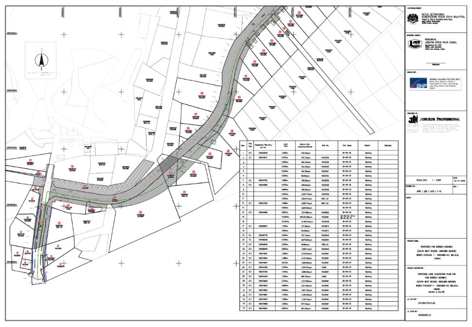
4 PAN BORNEO HIGHWAY PROJECT - PHASE 1 14 Simpang Mengayau Bingolon PAN BORNEO HIGHWAY PROJECT - PHASE 1 1 LEGEND : Sindumin 5 Kg. Melalia 6 Bongawan Beaufort Sepanggar Inanam Donggongon Pituru Tuaran Bulatan Berunggis Widening of Existing Road New Expressway/Bypass Temuno Sarang Rampayan Laut Kg. Nabutan Inclusion Is Pending Confirmation From KKRM Kg. Lumou Baru Sg. Baoto Kg. Toupos Sapi Nagoh Moynod Telupid Sandakan M32 24 Kg. Lot M Sukau 23 Kg. Perpanduan Datuk Moh 22 Agri Harvest Sg. Takala Kg. Sandau IGN Estate Madai Tawau Airport 21 Sepagaya 20 Sg. Kalumpang 15 WP SOUTH EAST Already tendered / awarded Remaining Tender Via Pre-Qualification No. 2 PACKA GE SECTION DIST.* (KM) WP 1 Sindumin - Kg Melalia WP 2 Kg Melalia - Beaufort 34.7 WP 3 Beaufort - Bongawan 22.4 WP 4 Bongawan - Papar WP 5 Papar - Donggongon 11.7 WP 6 Putatan - Inanam 19.6 WP 7 Inanam - Sepangar 9.9 WP 8 Sepangar - Bulatan Berungis 11.7 WP 9 Serusup - Pituru 20.8 WP 10 Pituru Rampayan Laut 32.2 WP 11 Rampayan Laut Sarang 7.3 WP 12 Sarang - Temuno 14.7 WP 13 Temuno Bingolon 20.3 WP 14 Bingolon Simpang Mengayau 28.1 WP 15 WP 16 Tawau Semporna Package 1 Phase 2 Kampung Checkpoint Sg Kalumpang WP 17 Sg Kalumpang Madai 19.0 WP 18 Madai IGN Estate 13.8 WP 19 IGN Estate Agri Harvest 18.5 WP 20 Agri Harvest - Sapagaya 17.9 WP 21 Lahad Datu Bypass 7 WP 22 Lahad Datu Bypass Kg Sandau 23.8 WP 23 Kg Sandau Sg Takala 25.0 WP 24 WP 25 Sg Takala Kg Perpaduan Datuk Moh Kg Perpaduan Datuk Moh Sukau WP 26 Sukau Kg. Lot M 18.1 WP 27 Kg Lot M Sandakan Mile WP 28 Sandakan Mile 32 Moynod 21.7 WP 29 Moynod Sapi Nangoh 20.4 WP 30 Sapi Nangoh Sg Baoto 22.1 WP 31 Sg Baoto Telupid 14.3 WP 32 Telupid Kg Lumou Baru 18.4 WP 33 Kg Lumou Baru Kg Toupos 17.6 WP 34 Kg Toupos - Kg Nabutan 26.0 WP 35 Kg Nabutan - Ranau 31.0 Project cost: RM12.86 B Land Acq Cost: RM 2.5B Total length: 704 Km Duration: Divided into: 35 packages 3


5 Land Acq Parcel Database Area Acquired 5 4

6 Selection of Road Alignment Lidar Survey Carried out by Licensed Surveyor 800 m to 1 km corridor Digital Terrain Model - at 0.5m resolution in ECW format. Digital Elevation Model/Digital Surface Model - Consist of a pre-set grid interval of ground points which represent the earth surface and include all objects in it. Digital Orthophotos - must be corrected (orthorectified) and repositioned (Geo Referenced) to the actual WGS 84 coordinate and GDM Digital Orthophotos files delivered in GEOTIFF or ECW Format with suitable image resolution. All digitized features and contour shall be converted in Moss Genio Format 5

7 Detail Engineering Survey (long & cross section) Divided into 35 packages Surveyed by 20 registered licensed surveyor Detail Surveys information given to PDP Consulting Engineers prepare alignment plan and engineering design plan 6
8 Acquisition Proposal by Licensed Surveyor Alignment plan and engineering design plan given to Licensed Surveyor. Licensed Surveyors (LS) purchase Digital Cadastral Data and Land Title Information's. LS prepare proposed acquisition plans in the digital form (DCDB & LTIS) LS submit digital plan (*.shape file) to Lands & Surveys Department 7


9 Automated Plan Checking Digital plan checking by LSD Overlay with Cadastral Data Base If everything in order, LSD advise LS to print proposed plans to be sign by Director of JKR as client department. Proposed Acquisition Plans submitted to LSD and to be approved Director/Deputy Director. Approved Acquisition Plans dan Draft Gazette Notification sent to Chief Minister Office for approval. Gazette Notification publish at government gazette. Lands officially acquired

10 Land Acq Parcel Development Database 8
11 Land Acq Parcel Development Database 9

12 Compensation Land Acq Parcel Database 10

13 Pan Borneo Alignment Plan 11

14 New Image on top of Google Earth 12

15 Land Acquisition Gazette Plan 13
16 Land Acquisition Gazette Notification 14


17 New Images for ground inspection to determine Land and Building Compensations Google Earth New Image on top of Google Earth 15
18 Historical Land Value Records to value land acquisition 16
19 Thank you 19
CLICK HERE TO KNOW MORE
 CLICK HERE TO KNOW MORE LANDS AND SURVEYS DEPARTMENT SABAH, MALAYSIA GEO-CADASTRE IN LAND ADMINISTRATION: SABAH S EXPERIENCE Sr Hj SAFAR B UNTONG, FISM, MRICS Director, Lands & Surveys Department Sabah,
JAYCORP BERHAD ( JAYCORP OR COMPANY )
") JAYCORP BERHAD ( JAYCORP OR COMPANY ) PROPOSED DIVERSIFICATION OF THE PRINCIPAL ACTIVITIES OF JAYCORP AND ITS SUBSIDIARIES ( JAYCORP GROUP ) TO INCLUDE CONSTRUCTION AND PROPERTY DEVELOPMENT 1. INTRODUCTION
JAYCORP BERHAD ( JAYCORP OR COMPANY ) PROPOSED DIVERSIFICATION OF THE PRINCIPAL ACTIVITIES OF JAYCORP AND ITS SUBSIDIARIES ( JAYCORP GROUP ) TO INCLUDE CONSTRUCTION AND PROPERTY DEVELOPMENT 1. INTRODUCTION
THE NATIONAL LAND CODE 1965 (NLC) IS A MALAYSIAN LAWS RELATING TO LAND AND LAND TENURE, THE REGISTRATION OF TITLE TO LAND AND OF DEALINGS THEREWITH
 IS A MALAYSIAN LAWS RELATING TO LAND AND LAND TENURE, THE REGISTRATION OF TITLE TO LAND AND OF DEALINGS THEREWITH") PROPERTY TAX REFORM THE NATIONAL LAND CODE 1965 (NLC) IS A MALAYSIAN LAWS RELATING TO LAND AND LAND TENURE, THE REGISTRATION OF TITLE TO LAND AND OF DEALINGS THEREWITH AND THE COLLECTION OF REVENUE THEREFROM
PROPERTY TAX REFORM THE NATIONAL LAND CODE 1965 (NLC) IS A MALAYSIAN LAWS RELATING TO LAND AND LAND TENURE, THE REGISTRATION OF TITLE TO LAND AND OF DEALINGS THEREWITH AND THE COLLECTION OF REVENUE THEREFROM
BOUSTEAD PLANTATIONS BERHAD (Company No.: 1245-M) (Incorporated in Malaysia)
 (Incorporated in Malaysia)") THIS CIRCULAR IS IMPORTANT AND REQUIRES YOUR IMMEDIATE ATTENTION. THIS CIRCULAR IS IMPORTANT AND REQUIRES YOUR IMMEDIATE ATTENTION. If you are in any doubt as to the course of action to be taken, you should
THIS CIRCULAR IS IMPORTANT AND REQUIRES YOUR IMMEDIATE ATTENTION. THIS CIRCULAR IS IMPORTANT AND REQUIRES YOUR IMMEDIATE ATTENTION. If you are in any doubt as to the course of action to be taken, you should
METHODOLOGY FOR THE DEVELOPMENT OF NATIONAL DIGITAL CADASTRAL DATABASE (NDCDB)
") KURSUS COORDINATED CADASTRAL SYSTEM (CCS) INSTITUT TANAH & UKUR NEGARA BEHRANG, PERAK METHODOLOGY FOR THE DEVELOPMENT OF NATIONAL DIGITAL CADASTRAL DATABASE (NDCDB) OLEH: PROF DR ABD MAJID BIN A KADIR
KURSUS COORDINATED CADASTRAL SYSTEM (CCS) INSTITUT TANAH & UKUR NEGARA BEHRANG, PERAK METHODOLOGY FOR THE DEVELOPMENT OF NATIONAL DIGITAL CADASTRAL DATABASE (NDCDB) OLEH: PROF DR ABD MAJID BIN A KADIR
SCOPE OF PRESENTATION
 INTERNATIONAL SYMPOSIUM AND EXHIBITION ON GEOINFORMATION Global Trends: Geoinformation For The New Economy Studies Toward the Development of Implementation Plan Of Coordinated Cadastral System for Peninsular
Crown Land Leasing Policy
 Management Manual 25 Chapter: Section: Approved By: Implementation: 6 (Licenses, Leases, Permits, Sales, Land Exchanges) 4 () Duff Montgomerie Deputy Minister Land Administration Division Land Services
STATE LAND AUDIT REPORT
 STATE LAND AUDIT REPORT 1 Presentation to the Portfolio Committee on Rural Development and Land Reform M514 Marks Building 30 March 2011 CHIEF SURVEYOR GENERAL Mr M RIBA Content 2 Background Project Objectives
Public Inspection for the Kuala Lumpur-Singapore High Speed Rail Frequently Asked Questions (FAQ)
") Public Inspection for the Kuala Lumpur-Singapore High Speed Rail Frequently Asked Questions (FAQ) Public Inspection 1. What is the purpose of Public Inspection? The Public Inspection is a mandatory process
Public Inspection for the Kuala Lumpur-Singapore High Speed Rail Frequently Asked Questions (FAQ) Public Inspection 1. What is the purpose of Public Inspection? The Public Inspection is a mandatory process
Replies to Queries of the Bidders
 Date: 07.12.2018 Replies to Queries of the Bidders SUB: Replies to queries of the bidders against Tender for carrying out survey works, opening of ROU & Manmad in Nashik GA to Dhule GA (approx. 300 km)
ORDINANCE NO AN ORDINANCE ESTABLISHING A UNIFORM SYSTEM FOR STREET ADDRESSING IN EMERY COUNTY
 ORDINANCE NO. 21505 AN ORDINANCE ESTABLISHING A UNIFORM SYSTEM FOR STREET ADDRESSING IN EMERY COUNTY The County Commission of the County of Emery, State of Utah, being the Legislative Body of said county,
City of Surrey s Digital Plan Submission Process
 City of Surrey s Digital Plan Submission Process Cadastral Update Karen Stewart, B.Tech. (GIS) Spatial Information Manager Peter Mueller, B.C.L.S., C.L.S. Survey Manager City of Surrey, British Columbia,
NEW DEVELOPMENTS IN THE REAL PROPERTY REGISTER AND CADASTRE IN LITHUANIA
 NEW DEVELOPMENTS IN THE REAL PROPERTY REGISTER AND CADASTRE IN LITHUANIA Jaunius Grigas E-mail: jaunius.grigas@registrucentras.lt Verona, 2008 FUNCTIONS OF STATE ENTERPRISE CENTRE OF REGISTERS Registration
Staff Report for Council Public Meeting
 Agenda Item 3.2 a Staff Report for Council Public Meeting Department: Division: Planning and Regulatory Services Development Planning Subject: Request for Comments Draft Plan of Subdivision - Elm Carrville
MnDOT Contract No Exhibit B. Scope of Work. Scope of Work
 MnDOT Contract No. 1032993 Contract General Description The purpose of this contract is to provide the State with the survey accurate re-establishment of designated Public Land Survey section boundaries
The Boundary and the Effects of Cadastral Surveying in Cyprus
 The Boundary and the Effects of Cadastral Surveying in Cyprus Aristi Louca, Margarita Fani Surveyor Engineers, Cyprus Association of Rural and Surveying Engineers The History of Cyprus goes back 11000
CADASTRAL STUDIES (MGU1014 / MGHU1514)
") CADASTRAL STUDIES (MGU1014 / MGHU1514) WEEK 8-LAW AND REGULATIONS (FIELD) SR DR. TAN LIAT CHOON 07-5530844 016-4975551 1 OUTLINE Field Survey Practice 2 FIELD SURVEY PRACTICE 3 Survey Datum For new survey
CADASTRAL STUDIES (MGU1014 / MGHU1514) WEEK 8-LAW AND REGULATIONS (FIELD) SR DR. TAN LIAT CHOON 07-5530844 016-4975551 1 OUTLINE Field Survey Practice 2 FIELD SURVEY PRACTICE 3 Survey Datum For new survey
An Overview of the eplan Journey with a Focus on the Victorian eplan 2025 Roadmap Dr Hamed Olfat
 An Overview of the eplan Journey with a Focus on the n eplan 2025 Roadmap Dr Hamed Olfat eplan Coordinator Land Use Chairman of Technical Committee ICSM eplan Working Group Outline eplan Overview ICSM
Further details of the Proposed Land Acquisition are set out in the following sections:
 HUA YANG BERHAD ( HYB or the Company ) -Proposed acquisition of land by Prop Park Sdn Bhd 1. INTRODUCTION The Board of Directors of HYB wishes to announce that the wholly-owned subsidiary of the Company,
REQUEST FOR PROPOSAL RFP # TOC17-001
 REQUEST FOR PROPOSAL RFP # TOC17-001 April 25, 2017 157 NW Columbia Avenue P. O. Box 183 Chapin, SC 29036 Tel.: (803) 345-2444 Fax: (803) 345-0427 April 25, 2017 REQUEST FOR PROPOSAL RFP # TOC17-001 The
AREC responsibilities, data and registries and the way of their distribution
 Data as a basis of the digital society PCC, 13-15 March 2018, Sofia AREC responsibilities, data and registries and the way of their distribution Vlatko Dimovski Agency for Real Estate Cadastre (AREC) the
PLEASE READ THE ENTIRE APPLICATION FORM PRIOR TO COMPLETING
 APPLICATION FOR EXEMPTION FROM PART LOT CONTROL The Corporation of the Town of Whitby 575 Rossland Road East, Whitby Ontario, L1N 2M8 Telephone: 905.430.4306 ~ Facsimile: 905.668.7812 PLEASE READ THE ENTIRE
Quality Improvement of the Real Estate Cadastre in Serbia
 , Serbia Key words: quality improvement, real estate information, quality assurance, Serbia SUMMARY The concept of cadastral modernization in the Republic of Serbia was defined in 1992, and it is being
Further details of the Proposed Acquisition are set out in the ensuing sections of this announcement.
 BERTAM ALLIANCE BERHAD ( BERTAM OR THE COMPANY ) PROPOSED ACQUISITION OF A PIECE OF LAND HELD UNDER COUNTRY LEASE ( CL ) 215465802 MEASURING APPROXIMATELY 1.709 HECTARE SITUATED AT KG KEPAYAN, DISTRICT
Work Type Definition and Submittal Requirements Work Type: Right-of-Way Surveys / Land Surveys
 The first section, Work Type Definition, provides a detailed explanation of the work type. The second section, Work Type Submittal Requirements, identifies the requirements a firm must meet to become pre-qualified
THE XXV FIG INTERNATIONAL CONGRESS IN MALAYSIA Kuala Lumpur, Malaysia, June 2014 at Kuala Lumpur Convention Centre
 CALL FOR PAPERS TO THE XXV FIG INTERNATIONAL CONGRESS IN MALAYSIA Kuala Lumpur, Malaysia, 16 21 June 2014 at Kuala Lumpur Convention Centre Dear Friend and Colleague, It is our privilege and honour to
GIS Based Tools for County Road Management Right-of-Way Land Value Analysis. January 12, 2012
 GIS Based Tools for County Road Management Right-of-Way Land Value Analysis January 12, 2012 Reasons for Needing Accurate Land Values Asset Management 1999 GASB Statement 34 Corridor Studies Scoping Studies
Compulsory Land Acquisition Delegations
 Board Meeting 30 May 2013 Agenda item no. 10(iii) Closed Session Compulsory Land Acquisition Delegations Recommendations It is recommended that the Board: i. Receive this report; ii. Grant delegated authority
Subdivision Application Form
 Subdivision Application Form Preliminary Layout Acceptance PLA Extension PLA Amendment Strata Conversion Form P Form P Amendment Final Approval Contact Information Name of Applicant (Contact Person): *If
Joeyaska Indian Reserve No. 2 Lower Nicola First Nation
 Land Description for Joeyaska Indian Reserve No. 2 Lower Nicola First Nation British Columbia Prepared under First Nations Land Management Act (S.C. 1999, c. 24) Prepared on: June 13, 2016 Table of Contents
LADM-based Crowdsourced 3D Cadastral Surveying Potential and Perspectives
 National Technical University Of Athens School of Rural and Surveying Engineering LADM-based Crowdsourced 3D Cadastral Surveying Potential and Perspectives Maria Gkeli, Surveying Engineer, PhD student
Parcel Boundaries in the Czech Republic
 Parcel Boundaries in the Czech Republic CZECH REPUBLIC Jiri Rydval, Libor Tomandl Czech Office for Surveying, Mapping and Cadastre inhabitants - 10.3 million territory 78,865 km 2 2 Contents: 1. A parcel
Italian Cadastre and Real Estate Rights and Mortgages Registration System
 CLGE General Assembly Italian Cadastre and Real Estate Rights and Mortgages Registration System Franco Maggio Central Director Cartography, Cadastre and Real Estate Rights and Mortgages Registration System
Measured surveys at the heart of every good survey is a strong specification (8064)
") FIG WW Christchurch 2016 TS03D 04/05/16 11.00 Measured surveys at the heart of every good survey is a strong specification (8064) Presented at the FIG Working Week 2016, May 2-6, 2016 in Christchurch,
FIG WW Christchurch 2016 TS03D 04/05/16 11.00 Measured surveys at the heart of every good survey is a strong specification (8064) Presented at the FIG Working Week 2016, May 2-6, 2016 in Christchurch,
The Importance of Performing Route Surveys in the State of Indiana. Presented to: March 6 th, 2013
 The Importance of Performing Route Surveys in the State of Indiana Presented to: March 6 th, 2013 Parsons Cunningham & Shartle Engineers 317-837-9900 www.pcsengineers.com Presented By: Chet Parsons, PE
APPENDIX B TOWN OF LITTLE COMPTON, RHODE ISLAND INSTRUCTIONS AND CHECKLIST FOR MINOR SUBDIVISION
 APPENDIX B TOWN OF LITTLE COMPTON, RHODE ISLAND INSTRUCTIONS AND CHECKLIST FOR MINOR SUBDIVISION These Instructions and Checklist apply to Minor Subdivisions a residential subdivision resulting in five
A Guide to Establishing Additional Service Areas in Rural Municipalities
 A Guide to Establishing Additional Service Areas in Rural Municipalities February 2014 Contents Introduction... 3 Purpose of this Guide... 3 Background... 3 What are the benefits to Rural Municipalities
Recent Developments concerning Land Administration in Austria
 Recent Developments concerning Land Administration in Austria Main topics e-government reference data go online / egeodata Austria new pricing and licensing / business models INSPIRE / PSI / national infrastructure
Shaping the Cadastral Infrastructure for a Digital Future
 DEPARTMENT OF LANDS PLANNING and the ENVIRONMENT Shaping the Cadastral Infrastructure for a Digital Future Craig Sandy Director Surveys Surveyor General Survey Branch NT Australia Digital Cadastral Databases
commercial outlets signature offices fusion streets sonduou. jalan lintas commercial outlets signature offices fusion streets
 commercial outlets signature offices fusion streets Lot No. 77-1, Ground & 1st Floor, Wisma New Far East, Jalan Lintas, 88300 Kota Kinabalu, Sabah. P.O.Box No. 11863, 88820 Kota Kinabalu, Sabah, Malaysia.
COUNTY GOVERNMENT OF LAMU Department of Land, Physical Planning, Infrastructure & Urban Development
 1 COUNTY GOVERNMENT OF LAMU Department of Land, Physical Planning, Infrastructure & Urban Development TERMS OF REFERENCE FOR OUTSOURCING OF CONSULTANCY SERVICES FOR SURVEY & REGULARIZATION OF KATSAIKAIKAIRU
Ownership Data in Cadastral Information System of Sofia (CIS Sofia) from the Available Cadastral Map
 from the Available Cadastral Map") Ownership Data in Cadastral Information System of Sofia (CIS Sofia) from the Available Cadastral Map Key words: ABSTRACT Lydmila LAZAROVA, Bulgaria CIS Sofia is created and maintained by GIS Sofia ltd,
Ownership Data in Cadastral Information System of Sofia (CIS Sofia) from the Available Cadastral Map Key words: ABSTRACT Lydmila LAZAROVA, Bulgaria CIS Sofia is created and maintained by GIS Sofia ltd,
Institute of Cadastral Surveying (Inc)
") Institute of Cadastral Surveying (Inc) RO. Box 775, Timaru Ph. & Fax: (03) 686 9400 Email: sec@ics.org.nz Web: www.ics.org.nz Page 1 6 May 2010 COMPLAINT ABOUT THE SURVEYOR GENERAL'S RULES FOR CADASTRAL
Institute of Cadastral Surveying (Inc) RO. Box 775, Timaru Ph. & Fax: (03) 686 9400 Email: sec@ics.org.nz Web: www.ics.org.nz Page 1 6 May 2010 COMPLAINT ABOUT THE SURVEYOR GENERAL'S RULES FOR CADASTRAL
Hi-tech Survey Operation using Modern Technologies: Concept & Process Flow
 Hi-tech Survey Operation using Modern Technologies: Concept & Process Flow Presented by Sri Biswaranjan Rath Asst. Director,CLR Board of Revenue, Odisha Limitations of present system of surveying Survey
Minerals and Mining (Compensation And Resettlement) Regulations, 2012 (L.I. 2175)
 Regulations, 2012 (L.I. 2175)") Minerals and Mining (Compensation And Resettlement) Regulations, 2012 (L.I. 2175) ARRANGEMENT OF REGULATIONS Regulations 1. Claims for compensation 2. Assessment of compensation 3. Compensation principles
Minerals and Mining (Compensation And Resettlement) Regulations, 2012 (L.I. 2175) ARRANGEMENT OF REGULATIONS Regulations 1. Claims for compensation 2. Assessment of compensation 3. Compensation principles
APPLICATION for MINOR SUBDIVISION REVIEW for CONCEPT and FINAL PLAT within COALVILLE CITY. Project Name: Project Address or Area: Name of Owner:
 APPLICATION for MINOR SUBDIVISION REVIEW for CONCEPT and FINAL PLAT within COALVILLE CITY For Office Use Only: Application #: Application Date: PC Approval Date: CC Approval Date: Community Development
Our policy of providing clients a personal service has been rewarded by a wide and diverse client base with high-level repeat commissions.
 1.0 Introduction Datum Surveying Consultants has professional, technical resources, equipment, experience and training to undertake any type of Survey and Mapping project expediently. Since inception in
IN THE MATTER OF THE Municipal Government Act being Chapter M-26 of the Revised Statutes of Alberta 2000 (Act).
.") IN THE MATTER OF THE Municipal Government Act being Chapter M-26 of the Revised Statutes of Alberta 2000 (Act). AND IN THE MATTER OF an application by the Town of Viking, in the Province of Alberta, to
IN THE MATTER OF THE Municipal Government Act being Chapter M-26 of the Revised Statutes of Alberta 2000 (Act). AND IN THE MATTER OF an application by the Town of Viking, in the Province of Alberta, to
QUESTIONNAIRE. 1. Authorizing statute(s) citation West Virginia Code and 11-1C-4(d)
 citation West Virginia Code and 11-1C-4(d)") QUESTIONNAIRE (Please include a copy of this form with each filing of your rule: Notice of Public Hearing or Comment Period; Proposed Rule, and if needed, Emergency and Modified Rule.) DATE: 6/8/15 TO:
QUESTIONNAIRE (Please include a copy of this form with each filing of your rule: Notice of Public Hearing or Comment Period; Proposed Rule, and if needed, Emergency and Modified Rule.) DATE: 6/8/15 TO:
LIS Development Project and Measures Proposed to Enhance Trust in the Land Administration System in Uganda
 Project for Design, Supply, Installation and Implementation of the Land Information System and Securing of Land Records (DeSILISoR) LIS Development Project and Measures Proposed to Enhance Trust in the
LAND DEVELOPMENT CHECKLIST GREEN TREE BOROUGH Green Tree Planning Commission 10 West Manilla Avenue Pittsburgh, PA
 TO BE COMPLETED BY BOROUGH: LAND DEVELOPMENT CHECKLIST GREEN TREE BOROUGH Green Tree Planning Commission 10 West Manilla Avenue Pittsburgh, PA 15220 412-921-1110 SP - - DATE STAMP RECEIVED NOTE TO ALL
Surveyor s Checklist
 Surveyor s Checklist Condominium Development & Registration Process Condominium Development and Registration Condo Development/ Registration Process: PART 1 -Marketing and Sales Process Condo Development/
CITY OF JOHANNESBURG
 DEVELOPMENT PLANNING ANNEXURE A CITY OF JOHANNESBURG AMENDMENT OF OF CHARGES IN RESPECT OF THE VARIOUS TOWN PLANNING AND TOWNSHIP ORDINANCES, DIVISION OF LAND ORDINANCE, 1986, THE BLACK COMMUNITIES DEVELOPMENT
COMMITTEE OF THE WHOLE MEETING NOVEMBER 7, 2016 WRITE-OFF OF PROPERTY TAXES AND RETENDERING TH LINE
 REPORT #FIN-2016-29 COMMITTEE OF THE WHOLE MEETING NOVEMBER 7, 2016 WRITE-OFF OF PROPERTY TAXES AND RETENDERING 6789 4TH LINE RECOMMENDATION That Finance Report #FIN-2016-29 be received, And that Council
Cadastral services and virtual office in e-cadastre
 Cadastral services and virtual office in e-cadastre Priit Kuus Estonian Land Board October 26, 2016 Coimbra Scope of data Cadastral parcels (as of September 2016) 674 383 cadastral parcels, i.e. 97,7 %
Meeting the Changing National Geospatial Information Needs. Palitha Udayakantha Surveyor General - Sri Lanka
 Meeting the Changing National Geospatial Information Needs Palitha Udayakantha Surveyor General - Sri Lanka Sri Lanka Location Latitude 5 55 10-9 50 6 North Longitude 79 31 19-81 52 36 East Area 65610
Demonstrate knowledge of, and extract, cadastral data from Landonline
 Page 1 of 5 Demonstrate knowledge of, and extract, cadastral data from Landonline Level 3 Credits 5 Purpose This unit standard is for people who are working in the surveying industry in jobs which involve
Plat Checklist PLAT TYPES AND DESCRIPTIONS
 Master Plan / Revision to Master Plan (For Platting Purposes Only) Preliminary/Final Plat Preliminary Plat Final Plat Minor Plat Replat Amended Plat Plat Checklist So that we may efficiently review your
The Survey Data Model Technology A practical survey solution to generate all levels of spatial and e-governance outcomes.
 Land Governance in a Rapidly Changing Environment Annual World Bank Conference on Land and Poverty April 24 & 25, 2012 The Survey Data Model Technology A practical survey solution to generate all levels
Number Same. This document provides procedural direction to implement Policy PL Onshore Windpower Development on Crown Land.
 Ministry of Natural Resources Subject ONSHORE WINDPOWER DEVELOPMENT ON CROWN LAND NON-COMPETITIVE APPLICATION Procedure PL 4.10.04 Compiled by Renewable Energy Program Replaces Directive Title Same Number
6. REPORT BY THE CHAIRPERSON OF THE FENDALTON/WAIMAIRI COMMUNITY BOARD - 4 NOVEMBER 2009
 6. REPORT BY THE CHAIRPERSON OF THE FENDALTON/WAIMAIRI COMMUNITY BOARD - 4 NOVEMBER 2009 1. POUND ROAD ROAD STOPPING AND LAND SWAP General Manager responsible: General Manager City Environment, DDI 941-8608
DUTALAND BERHAD 1. INTRODUCTION
 DUTALAND BERHAD PROPOSED DISPOSAL BY PERTAMA LAND & DEVELOPMENT SDN BHD, A WHOLLY-OWNED SUBSIDIARY OF DUTA PLANTATIONS SDN BHD WHICH IN-TURN IS WHOLLY-OWNED BY DUTALAND BERHAD, OF THE PLANTATION ASSETS
Shoowahtlans Indian Reserve No. 4 Metlakatla
 Land Description for Shoowahtlans Indian Reserve No. 4 Metlakatla British Columbia Prepared under First Nations Land Management (S.C. 1999, C.24) Prepared on: October 7 th, 2015 October 7, 2015 Table of
FIG Congress 2010 Facing the Challenges Building the Capacity Sydney, Australia, April
 Setting up the infrastructure for improving the development of Cadastre in Greece Dr. Dimitris ROKOS, Dr. Konstantinos KYRIAZIS and Dr. Panos LOLONIS KTIMATOLOGIO S.A. (Hellenic Cadastre) Source: wikipedia
ASCTECH CONSULTANT COMPANY PROFILE
 ASCTECH CONSULTANT COMPANY PROFILE Date:Sept 2011 1 ASCTECH CONSULTANT No 21 Lot 158, Taman Seputeh, Lrg Lengkuas 2, Luyang, Jalan Damai, 88300 Kota Kinabalu Phone No:088250940 Fax:088250940 email:asctech@gmail.com
ATTACHMENT 2: CONSULTATION UPDATE NO. 3 PART 3 LANDOWNER ENGAGEMENT
 ATTACHMENT 2: CONSULTATION UPDATE NO. 3 PART 3 LANDOWNER ENGAGEMENT TABLE OF CONTENTS 1.0 INTRODUCTION... 1 Page 1.1 Purpose of Update... 1 1.2 Program Scope (May 1 to December 31, 2014)... 1 2.0 COMPONENTS
PROPERTY INFO FOR SALE 2001 N HOUSTON SCHOOL RD. Trafic Counts Demographic Summary. + Excellent retail/ofice corner. + Good residential density
 FOR SALE 2001 N HOUSTON SCHOOL RD NWC N HOUSTON SCHOOL RD & PLEASANT RUN RD, LANCASTER, TX 75134 PROPERTY INFO + Excellent retail/ofice corner + Good residential density + Good trafic counts + Site is
Analysis: Development Plan Designation = RA Resource and Agriculture Not In Compliance
 806-A Manitoba Avenue Selkirk, Manitoba R1A 2H4 Toll Free: 800-876-5831 Phone: 204-482-3717 Fax: 204-482-3799 Date: September 22, 2016 File: S16-2682 To: From: Location: Andrew Weremy, CAO Rural Municipality
BULGARIAN CADASTRE A GUARANTEE FOR THE OWNERSHIP RIGHTS IN IMMOVABLE PROPERTIES
 4 TH INTERNATIONAL CONFERENCE RECENT PROBLEMS IN GEODESY AND RELATED FIELDS WITH INTERNATIONAL IMPORTANCE February 28 - March 2, 2007, Inter Expo Centre, Sofia, Bulgaria BULGARIAN CADASTRE A GUARANTEE
INSPIRE Thematic Working. Cadastral parcels. September 2008
 INSPIRE Thematic Working Cadastral parcels September 2008 The INSPIRE context The INSPIRE Directive Its aim is to build the INfrastructure for Spatial InfoRmation in Europe The INSPIRE Directive has been
SECTION 10 STANDARD PLATS
 SECTION 10 - STANDARD PLATS Subdivision 1: Purpose Standard Plats allow the subdivision of land into lots smaller than the minimum metes and bounds size in the zoning district, and control road development
OFFICIAL GAZETTE OF THE REPUBLIC OF KOSOVA / No. 33 / 23 NOVEMBER 2012, PRISTINA
 OFFICIAL GAZETTE OF THE REPUBLIC OF KOSOVA / No. 33 / 23 NOVEMBER 2012, PRISTINA LAW No. 04/L-136 ON THE REGISTRATION OF A PLEDGE IN THE REGISTRY OF MOVABLE PROPERTY Assembly of Republic of Kosovo, Based
Establishing a Wetland Bank in Minnesota
 Establishing a Wetland Bank in Minnesota Updated February 1, 2018 This document provides a general summary of the key steps in establishing an individual wetland bank site within the state wetland banking
Value Chain Mapping. 3D Cadastre and Valuation The Added Value of 3D Geo-information Richard Witmer, Kadaster NL, 30 March 2017
 Value Chain Mapping 3D Cadastre and Valuation The Added Value of 3D Geo-information Richard Witmer, Kadaster NL, 30 March 2017 Agenda Purpose: why look at 3D cadastre and valuation? Approach: what we did.
Welcome to District 6-0
 Welcome to District 6-0 Introductions Traffic Services Manager Fran Hanney 610.205.6560 fhanney@pa.gov District Permits Manager Matthew Miele 610.205.6795 mmiele@pa.gov Right-of-Way Administrator Matthew
Well Survey Requirements
 Well Survey Requirements Directive PNG003 November 2015 Revision 1.0 Governing Legislation: Act: The Oil and Gas Conservation Act Regulation: The Oil and Gas Conservation Regulations, 2012 Record of Change
Improvement of Effectiveness Present Developments in Hungarian Land Administration
 Improvement of Effectiveness Present Developments in Hungarian Land Administration Gyula IVÁN and András OSSKÓ, Hungary Key words: Land Administration, Cadastre, Land Registry SUMMARY New Act on Surveying
REQUEST FOR PROPOSALS
 REQUEST FOR PROPOSALS Coastal LiDAR Mapping Closing date and time: 4:00 pm on Monday, May 9, 2016 Closing Location: Regional District of Nanaimo Strategic & Community Development 6300 Hammond Bay Road
Republika e Kosovës Republika Kosovo - Republic of Kosovo Kuvendi - Skupština - Assembly
 Republika e Kosovës Republika Kosovo - Republic of Kosovo Kuvendi - Skupština - Assembly Law No. 04/L-144 ON ALLOCATION FOR USE AND EXCHANGE OF IMMOVABLE PROPERTY OF THE MUNICIPALITY Assembly of Republic
The Corporation of the TOWN OF MILTON
 Report to: From: Mayor Krantz and Members of Council Troy McHarg, Town Clerk Date: February 23, 2009 Report No. ES-012-09 Subject: Ninth Line Corridor Boundary Adjustment Proposal by Mississauga RECOMMENDATION:
Land Designation & Leasing
 Land Designation & Leasing CANDO Workshop March 2017 Presented by: Emilie Garnier Colleen Thomas Overview Economic Activities $$$ LEASE DESIGNATION RESERVE LAND USE PLANNING 2 Economic Activities = $$$
SMOKY LAKE COUNTY. Alberta Provincial Statutes. To provide a process to close a Government Road Allowance, or cancel a surveyed Road Plan.
 SMOKY LAKE COUNTY Title: Road Closure or Cancellation Policy No.: 16-03 Section: 03 Page No.: 1 of 11 E Legislation Reference: Alberta Provincial Statutes Purpose: To provide a process to close a Government
A Geocoded Cadastral Fabric as a Precondition for a Sustainable Land Management System
 A Geocoded Fabric as a Precondition for a Sustainable Land Management System Gottfried KONECNY, Germany; J.P. LAUZON, Canada; Abdul Salam MOHAMMED, India Key words: SDI,, Parcel Boundaries, GPS-GNSS, Land
Directorate of Survey and Mapping NAMIBIA. Cadastral Information System. Vehupisa Kasuko Tjatindi Surveyor Directorate of Survey and Mapping NAMIBIA
 Vehupisa Kasuko Tjatindi Directorate of Survey and Mapping NAMIBIA Tel: +64 61 965000 Directorate of Survey and Mapping NAMIBIA Cadastral Information System Introduction Over the past few decades cadastral
The Challenge to Implement International Cadastral Models Case Finland 1
 The Challenge to Implement International Cadastral Models Case Finland 1 Tarja MYLLYMÄKI and Tarja PYKÄLÄ, Finland Key words: cadastre, modelling, LADM, INSPIRE SUMMARY Efforts are currently made to develop
Republika e Kosovës Republika Kosovo - Republic of Kosovo Kuvendi - Skupština - Assembly
 Republika e Kosovës Republika Kosovo - Republic of Kosovo Kuvendi - Skupština - Assembly Law No. 04/L-136 ON THE REGISTRATION OF A PLEDGE IN THE REGISTRY OF MOVABLE PROPERTY Assembly of Republic of Kosovo,
City of Leavenworth DEPARTMENT OF DEVELOPMENT SERVICES MAJOR SUBDIVISION APPLICATION 1
 Proposed Name of Subdivision: City of Leavenworth DEPARTMENT OF DEVELOPMENT SERVICES MAJOR SUBDIVISION APPLICATION 1 FOR PRELIMINARY SUBDIVISION APPROVAL This application must be filled out legibly, in
Land Administration System in Russian Federation
 Sergey VOLKOV, Russia Key words: land administration, market economy, land management, land resources. SUMMARY Principle source of economic and social development of Russian Federation in XXI century will
The Fit- for-purpose Concept
 The Fit- for-purpose Concept Building Spatial Frameworks for Sustainable Land Governance in Sub-Sahara Africa Prof. Stig Enemark Honorary President Aalborg University, Denmark LAND POLICIES AND LAND GOVERNANCE,
Survey Manual Public Land Surveys
 Survey Manual Public Land Surveys March 30, 2012 Revisions March 30, 2012 revisions: Rearranged information and added a preamble indicating this document applies to amending existing public land surveys.
e-cadastre and Photo-Interpretation Technologies
 UNECE- WPLA EFFICIENT AND TRANSPARENT LAND MANAGEMENT IN ECE COUNTRIES 4 March 2010 - Baku, Azerbaijan e-cadastre and Photo-Interpretation Technologies The Italian experience as an example of Good Practice
REPORT OF THE CHIEF LEGISLATIVE ANALYST
 REPORT OF THE CHIEF LEGISLATIVE ANALYST DATE: October 28, 2016 TO: Honorable Members, Planning & Land Use Management Committee FROM: SUBJECT: SUMMARY Sharon M. Chief Legislative Analyst Application Process
Application Procedures for Easements or Rights of Way on City of Fort Collins Natural Areas and Conserved Lands March 2012
 Application Procedures for Easements or Rights of Way on City of Fort Collins Natural Areas and Conserved Lands March 2012 IMPORTANT NOTE: This document was created to accompany the City of Fort Collins
4. INTRODUCTION AND OVERVIEW PUBLIC MEETINGS
 TOWNSHIP OF CRAMAHE PUBLIC MEETING DATE: MARCH 8, 2016 TIME: PLACE: 6:45 PM COUNCIL CHAMBERS Page 1. CALL TO ORDER at 6:45 pm 2. RECORDING EQUIPMENT Members of the Public are to advise the Clerk of the
RULES OF THE GEORGIA STATE BOARD OF REGISTRATION FOR PROFESSIONAL ENGINEERS AND LAND SURVEYORS CHAPTER APPLICATIONS TABLE OF CONTENTS
 RULES OF THE GEORGIA STATE BOARD OF REGISTRATION FOR PROFESSIONAL ENGINEERS AND LAND SURVEYORS CHAPTER 180-7 APPLICATIONS TABLE OF CONTENTS 180-7-.07 Maps and Plats. All maps, plats and similar documents
ARTICLE 5 MINOR SUBDIVISION/LAND DEVELOPMENT
 ARTICLE 5 MINOR SUBDIVISION/LAND DEVELOPMENT SECTION 501 ONLY FINAL PLAN REQUIRED The classification of a proposed subdivision as a "Minor Subdivision" shall only require the submission, review and approval
LAND LAW AND SURVEY REGULATION (SGHU 3313)
") LAND LAW AND SURVEY REGULATION (SGHU 3313) WEEK 8-RESERVATION OF LAND SR DR. TAN LIAT CHOON 07-5530844 016-4975551 1 OUTLINE Reservation of Land for Public Purpose (S62) Leasing of Reserved Land (S63)
LAND LAW AND SURVEY REGULATION (SGHU 3313) WEEK 8-RESERVATION OF LAND SR DR. TAN LIAT CHOON 07-5530844 016-4975551 1 OUTLINE Reservation of Land for Public Purpose (S62) Leasing of Reserved Land (S63)
APPLICATION FOR SITE PLAN CONTROL for applying under Section 41 of the Planning Act, R.S.O. 1990, CHAPTER P. 13 (as amended)
") for applying under Section 41 of the Planning Act, R.S.O. 1990, CHAPTER P. 13 (as amended) APPLICATION: It is the responsibility of the Owner or Authorized Agent to provide complete and accurate information
for applying under Section 41 of the Planning Act, R.S.O. 1990, CHAPTER P. 13 (as amended) APPLICATION: It is the responsibility of the Owner or Authorized Agent to provide complete and accurate information
An Opportunity for Change
 Land Registry s Digital Mapping Project A Driver for Change Dr Paddy Prendergast FIS Department of Spatial Information Sciences Dublin Institute of Technology, IRELAND An Opportunity for Change Existing
Borneo Property Ltd. The Banyan Curve W ater Front Chalets P ort Dickson, M alaysia
 Borneo Property Ltd 2 Queens Drive, West Acton, Ealing, London W3 OHA Tel: 0208 752 0445 & 07788 55 0797 Fax: 020 8752 0219 email : lai@bor neoproper ty.co.uk The Banyan Curve W ater Front Chalets P ort