Welcome to District 6-0
|
|
|
- Garey Blake Greene
- 6 years ago
- Views:
Transcription

1 Welcome to District 6-0
2 Introductions Traffic Services Manager Fran Hanney District Permits Manager Matthew Miele Right-of-Way Administrator Matthew Kulpa Chief of Surveys Richard Shewman Permits Clerical Supervisor Mary Ellen Culhane
3 Why are we here? Remind everyone that Right-of-Way is important, it is a critical path item that should not be an after thought Recommend that designers include the Right-of-Way plan process as part of their proposal to their clients Inform designers what the District is looking for in Right-of-Way plans so that submissions can be approved in fewer cycles
4 Right-of-Way is not an obstacle unless and until proven to be so What does this mean? Traffic impacts and required mitigation of those impacts are identified in the TIS. Then needed Rightof-Way is identified to construct the improvements. Applicant must attempt to acquire Right-of-Way by amicable means based on an appraisal plus restoration and a small inducement for the inconvenience If after reasonable attempts based on the approach above, Right-of-Way cannot be acquired, please submit the documentation to the Department for review. Alternative mitigation may be required.
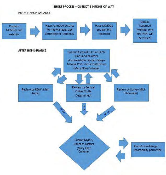
5 WHAT IS SO DIFFERENT ABOUT THE DISTRICT 6-0 RIGHT OF WAY PROCESS? Allows for HOP issuance prior to full Right-of-Way plan Still requires M950D-1 to be recorded prior to HOP issuance as well as all other requirements Conditions the HOP to require Right-of-Way plan submission within 60 days of HOP issuance DISCLAIMER- This modification is only for District 6-0, you must follow the guidance set forth in Publication 282
6 Condition THIS PERMIT WILL NOT BE CLOSED OUT UNTIL THE PERMITTEE HAS SUPPLIED THE DEPARTMENT WITH AN APPROVED AND RECORDED SET OF RIGHT-OF-WAY (ROW) DEDICATION PLANS. FURTHER, THE FORMAL ROW DEDICATION PLANS MUST BE SUBMITTED WITHIN SIXTY (60) DAYS OF HOP ISSUANCE. THE DEPARTMENT WILL NOT ACCEPT REQUESTS FOR PERMIT CLOSE OUT NOR RELEASE OF ESCROW UNTIL THE FORMAL ROW PLANS ARE PROVIDED TO THE DISTRICT PERMITS MANAGER (MATT MIELE, P.E.) AND FORMALLY APPROVED BY THE DISTRICT ROW ADMINISTRATOR (MATT KULPA). BE AWARE THAT THE LETTER OF CREDIT WILL NOT BE REDUCED TO 20% NOR WILL THE TWO (2) YEAR WARRANTY PERIOD BEGIN UNTIL THE RIGHT-OF-WAY PLANS ARE APPROVED BY THE DISTRICT, SENT TO HARRISBURG FOR THE SECRETARY S SIGNATURE, AND ULTIMATELY RECORDED IN THE COUNTY COURTHOUSE. THE PERMITTEE IS RESPONSIBLE FOR THE PREPARATION OF THESE PLANS IN ACCORDANCE WITH PUBLICATION 14M (DM-3), CHAPTER 3 RIGHT-OF-WAY PLANS AND PENNDOT SOL ("REVISION TO RIGHT-OF-WAY PLAN TITLE SHEET" DATED AUGUST 12, 2013) AND IS RESPONSIBLE FOR THE RECORDING OF THESE PLANS.
7
8 Frequently Asked Questions Submission (what, where, how many, review time)? Three hard copy submissions that include: a full size set of Right-of-Way plans in accordance with Publication 14 (Design Manual Part 3), all previously recorded documents such as M950- D1, deed showing property ownership, any title search documentation, letter form surveyor attesting that reference markers have been installed and three transmittal sheets addressed to each reviewer (ROW- Matt Kulpa, Central Office- To Be Determined, Surveyor- Rich Shewman) submitted to: Permits Unit, 7000 Geerdes Blvd, King of Prussia, PA The Department tries to perform reviews within 30 days. However, review times vary based on work load and complexity of the project. Why is this process necessary? Although the Department has acquired the Right-of-Way already through the M950D1 process, the Department requires that Right-of-Way plans be prepared in accordance with Publication 14M (Design Manual Part 3) for Departmental record keeping purposes. When should I start the process? ASAP. Failure to complete Right-of-Way plans will result in the Department not allowing work to begin and/or the retention of restoration security (Letter of Credit). Who do I call if I have questions? For status contact Matthew Miele, District Permits Manager. For review questions, contact the reviewer making the comments
9 How will comments be sent back? All official returns will be returned by the Permits Unit. The returns will be made via hard copy (could be printed ). Engineers are welcome to work with reviewers directly. However, since the Permits Unit is the central point of contact, all official submissions MUST be submitted, via hardcopy, to the Permits Unit. Are there any fees associated with review? Why isn t the review done through EPS? There is no fee for the review of Right-of-Way plans. The process consists of submissions being sent back and forth numerous times and the EPS system does not have a module set up that adequately, in our opinion, addresses the project work flow. What do I do after the plans are approved? Submit a mylar set and one original paper set of plans and all other supporting documentation such as review approvals and recorded M950D1. The District will sign off on the mylar and paper set and send the mylar and paper set up to Harrisburg for the Secretary of Transportation s signature. After the District receives the signed mylar and paper set, the mylar and paper set (and 2 microfilms) will be returned for recording. Who records and what is that process? The Department expects that the recording be done by the permittee or the permittee s engineer. Each County Recorder of Deeds has its own fee schedule and requirements, it is suggested that you contact the appropriate County Recorder of Deeds office prior to the submission of the mylar plan to the Department.
10 What do I do after the plans are recorded? Recorded mylar set of plans and microfilm sets must be sent back to the District Permits Unit for archiving. In addition to the recorded mylar set and microfilm sets, the Permits Unit requests that a CD containing all recorded documents such as the M950D1s and the final recorded plan in PDF format be submitted as well. The Right-of-Way process would be considered complete after the Department receives the CD, recorded mylar set and microfilm set of plans. How do I get the Section number? The District Permits Manager will provide the 3 character section number. Using the cover sheet of the plans, a project specific section number that can be used to identify the permittee will be given. An example, a permit in the name of District Permits Manager would most likely have DPM as the section number.
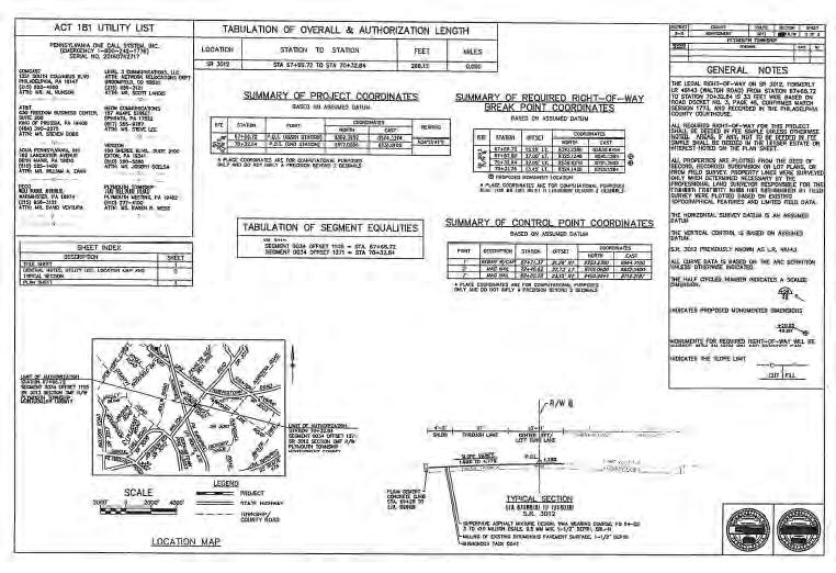
11 PennDOT District 6-0 Right-of-Way Plan Submission Guidelines Below is a guide to assist with submission for Right-of-Way plan review and approvals: 1st Submission for plan review You will be submitting 3 copies of the Right-of-Way plans per the requirements below. Make sure that you indicate the submission number on the transmittal or letter (i.e., submission #1). 1) 1 copy of Right-of-Way plans w/transmittal to Matthew Kulpa, District 6-0 Right-of- Way Administrator. 2) 1 copy of Right-of-Way plans w/transmittal to To Be Determined, Field Liaison, Highway Design & Technology Section, Bureau of Design. 3) 1 copy of Right-of-Way plans w/transmittal to Richard Shewman, P.L.S., District 6-0 Chief of Surveys. 4) 1 copy of the eps Application Summary with each of the three (3) packages. 5) 1 copy of Highway Occupancy Permit (if the permit has been issued) with each of the three (3) packages. 6) 1 copy of recorded 950D-1 form(s), all appropriate deeds, and documentation of cleared title search with each of the three (3) packages (if applicable). All three sets of plan submission packages should be submitted under one main letter directed to Matthew Miele, P.E., Highway Occupancy Permits Manager, so they can be disbursed to the various PennDOT reviewing personnel.
12 2nd Submission and any subsequent submissions for plan review Plans will need to resubmit plans to any PennDOT personnel that did not issue an approval letter. Make sure that you indicate the submission number on the transmittal or letter (i.e., submission #2). 1) 1 copy of Right-of Way plans w/transmittal to Matthew Kulpa, District 6-0 Right-of-Way Administrator, if necessary. 2) 1 copy of Right-of-Way plans w/transmittal to To Be Determined, Field Liaison, Highway Design & Technology Section, Bureau of Design, if necessary. 3) 1 copy of Right-of-Way plans w/transmittal to Richard Shewman, PLS., District 6-0 Chief of Surveys, if necessary. 4) 1 copy of the eps Application Summary with each of the three (3) packages. 5) 1 copy of Highway Occupancy Permit (if the permit has been issued) with each of the three (3) packages. 6) 1 copy of recorded 950D-1 form(s), all appropriate deeds, and documentation of cleared title search with each of the three (3) packages (if applicable). All sets of plan submission packages should be submitted under one main letter directed to Matthew Miele, P.E., Highway Occupancy Permits Manager, so they can be disbursed to the various PennDOT reviewing personnel.
13 Mylar Submission Once all necessary PennDOT M950-D1 forms have been recorded and plan approvals have been issued by Matthew Kulpa, District 6-0 Right-of-Way Administrator, Richard Shewman, P.L.S., District 6-0 Chief of Surveys and To Be Determined Field Liaison, Highway Design & Technology Section, Bureau of Design, mylars/paper copies of the Right-of-Way plans should be prepared, signed and sealed by the Project Engineer and Surveyor and submitted to Matthew Miele, P.E., Highway Occupancy Permits Manager. The mylars/paper copies will be forwarded to Central Office in Harrisburg for signatures and to be notarized. (Please note that you will need to clarify with PennDOT and the County Recorder of Deeds Office the plan requirements needed for submission and recording (i.e., mylar copies, paper copies, or microfilm etc.). Once mylars/paper copies/microfilm are returned from PennDOT District 6-0, you should record the mylars/paper copies/microfilm at the County Courthouse. The Recorder of Deeds will return one Cover Sheet to you to be returned to PennDOT, along with a recording receipt. These two items will be returned to PennDOT as part of the Final Right-of-Way Submission Package.
14 Final Right-of-Way Submission Package The final Right-of-Way submission will consist of hard copies and electronic copies as listed: Hard Copies of the following documents: 1) Submission letter to Matthew Miele, P.E., Highway Occupancy Permits Manager listing all of the recorded Right-of-Way plans and documents attached as part of the final Right-of-Way submission package. 2) Original of the recorded mylar cover sheet with the recording information filled in by the County Representative. 3) One copy of the County Recorder of Deeds receipt. One CD with PDFs of the final recorded Right-of-Way plans and documents including: 1) PDF of the eps Application Summary. 2) PDF of the Highway Occupancy Permit (if a permit has been issued). 3) PDF of the Recorded Right-of-Way plans (make sure the PDF plans show the current recording information filled in by the County Representative). 4) PDF of the County Recorder of Deeds receipt for recording the Right-of-Way plan set/microfilm. 5) PDF of the Right-of-Way approval letter from Matthew Kulpa, District 6-0 Right-of-Way Administrator 4) PDF of the Plan Review Report approval issued from To Be Determined, Field Liaison, Highway Design & Technology Section, Bureau of Design. 6) PDF of the survey approval letter issued by Richard Shewman, P.L.S., District 6-0 Chief of Survey. 7) PDFs of all recorded M-950 D1 Deed Fee Simple (No Monetary Consideration), M-950 D2 Deed of Easement (No Monetary Consideration), M-950 D3 Deed of Easement (Drainage) forms or any other pertinent recorded PennDOT forms relative to the Right-of-Way plans for the project. 8) PDF of the County Recorder of Deeds receipts for all recorded M-950 D1, M-950 D2 and M-950 D3 forms or any other pertinent recorded PennDOT forms relative to the Right-of-Way plans for the project. 9) PDFs of any Slope Easements, Sight Line Easements or any other pertinent recorded easements relative to the Right-of-Way plans for the project. 10) PDF of the County Recorder of Deeds receipts
15 RIGHT-OF-WAY ADMINISTRATOR REVIEW TITLE SHEET A) Correct Signature Block B) Correct Notary Block C) Plan title (For example, Drawing depicting ROW to be deeded to the Department) D) Is the proper section of the PA Code referenced
16 RIGHT-OF-WAY ADMINISTRATOR REVIEW INDEX SHEET A) Location Map B) Property owner List C)Proper General Notes
17 RIGHT-OF-WAY ADMINISTRATOR REVIEW PROPERTY PLAN SHEETS A) Legend and Cross Hatching of Required Rightof-Way B) Other Acquisitions Properly Identified With leader Lines C) Is the Type of Acquisition Appropriate D) Correct Standard Plan Note on the Plan E) Property Owner information Block Complete and Correct
18 BREAK

19 DM Part 3 Chapter 3 Introduction Plan Sheet Requirements General Notes Geometric Data Plan Requirements Property Plot Plans
20 INTRODUCTION - STANDARD RIGHT-OF-WAY PLANS The purpose of the chapter is to: Provide Guidance for the orderly Preparation of R/W plans. Provide Methods and Procedures.
21 INTRODUCTION - STANDARD RIGHT-OF-WAY PLANS To acquire property, a plan MUST: identify owners (or reputed owners). be filed as public record. be the basis for determining property damages. indicate the location, extent, and character of the property to be acquired. Any question, contact the Office of Chief Counsel. Plans must be developed to the same standards as construction plans in accordance with Chapter 13 of the Manual.
22 TITLE SHEET
23 TITLE SHEET IDENTIFICATION BLOCK The following information shall be provided in the Identification Block in the upper right-hand corner. 1. State Route. 2. Section Number with Suffix "R/W". 3. Engineering District. 4. County or Counties. 5. Township, Borough or City. 6. Total Number of Sheets.

24 TITLE SHEET
25 TITLE SHEET
26 TITLE SHEET
27 INDEX SHEET
28 INDEX SHEET Project Location
29 INDEX SHEET Title Block
30 INDEX SHEET Index Block Tabulation of Segment Equalities
31 INDEX SHEET Property Owners Listing
32 INDEX SHEET Drawing Legend
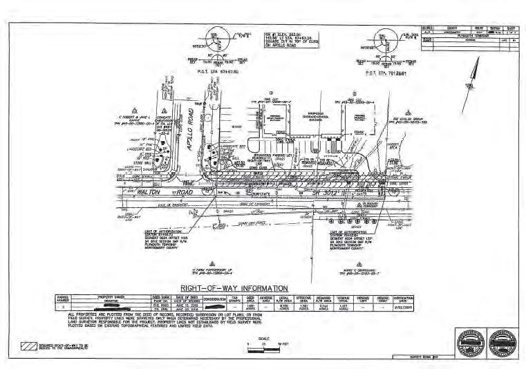
33 INDEX SHEET NOTE: No R/W Lines Property Lines must close Check Take vs Notake parcels No Topo other than streams, RR and Bridges
34 INDEX SHEET GENERAL NOTES Note Use Applicable Notes (Discuss) List Basis for Legal R/W data for all involved routes List PA One Call Phone number and Serial number List all applicable easement notes Verify previous dedicated R/W
35 INDEX SHEET - GEOMETRIC DATA
36 INDEX SHEET - GEOMETRIC DATA


37 Note GEOMETRIC DATA Provide project coordinate list for all Base Lines Provide coordinate list of required R/W break points Provide traverse sketch and control point coordinates District Survey Manager must review and approve reference ties and R/W monuments
38 Note PLANS If R/W monuments are proposed, express all breaks to two (2) decimals Show scaled dimensions to nearest foot Show easement break to nearest foot Show all utilities, and label reserved and/or substitute areas as necessary according to DM5
39 PLANS Note When possible, required R/W lines should parallel R/W Base Lines Label all topography Show all wells and septic Drainage features must be within R/W, or easement area. Structures and guide rail must be within R/W Show all driveway adjustments (Temporary Construction Easement (TCE) or knock out blocks)
40 PROPERTY PLOT PLANS Need is determined by District R/W Unit
41 PROPERTY PLOT PLANS Note Show and label all buildings and other improvements Crosshatch Required R/W Include all applicable notes Compute required area (acre vs square feet)
42 EASEMENTS Easements are a legal interest in property. Easements may restrict the property owner to physically use the property.
43 TYPES OF EASEMENTS Aerial Easements Slope Easements Drainage Easements Channel Easements Occasional Flowage Easements Temporary Construction Easements Legal R/W Converted to Aerial Easements Underground Structure Support Easements Sound Barrier Easements Sight Distance Easements ITS Conduit Easements Sidewalk Easements Traffic Signal Easements Wetland Mitigation Easements Stream Mitigation Easements Terrestrial Mitigation Easements NOTE: Contact the Assistant Counsel - Environmental Section for guidance.
44 EASEMENT NOTES ON PROPERTY PLOT PLANS Slope Easements Easements and Other Notes placed on each Property Plot. The following easement definitions are to be used, as applicable. SLOPE EASEMENT. AN EASEMENT FOR THE SUPPORT AND PROTECTION OF THE HIGHWAY, INCLUDING THE RIGHT TO CONSTRUCT, INSPECT, MAINTAIN, REPAIR, RECONSTRUCT AND ALTER DRAINAGE FACILITIES AND THE CONTOUR OF THE LAND. THE EASEMENT SHALL NOT PREVENT THE PROPERTY OWNER FROM MAKING ANY LEGAL USE OF THE AREA WHICH IS NOT DETRIMENTAL TO THE NECESSARY SUPPORT AND PROTECTION OF THE HIGHWAY RIGHT-OF-WAY AND THE SAFETY OF THE TRAVELING PUBLIC.
45 EASEMENT NOTES ON PROPERTY PLOT PLANS Temporary Construction Easements Easements and Other Notes placed on each Property Plot. The following easement definitions are to be used, as applicable. TEMPORARY CONSTRUCTION EASEMENT. AN EASEMENT TO USE THE LAND AS NECESSARY DURING CONSTRUCTION OF THE PROJECT. TH E EASEMENT IS REQUIRED ONLY UNTIL THE CONSTRUCTION OR WORK INDICATED BY THE PLAN IS COMPLETED, UNLESS SOONER RELINQUISHED IN WRITING BY THE DEPARTMENT.

46 EASEMENT NOTES ON PLANS & PROPERTY PLOT PLANS Steps, Walls, and Sidewalk Easements STEPS (or others) SHALL BE INCLUDED AS AN ITEM OF PROPERTY DAMAGE (or CONSTRUCTION). SIDEWALK EASEMENT. AN EASEMENT FOR THE CONSTRUCTION, INSPECTION, MAINTENANCE, REPAIR, RECONSTRUCTION AND ALTERATION OF A SIDEWALK. THE EASEMENT SHALL NOT PREVENT THE PROPERTY OWNER FROM MAKING ANY LEGAL USE OF THE AREA WHICH IS NOT DETRIMENTAL TO ITS USE FOR SIDEWALK PURPOSES.
47 PRIVATE ACCESS NOTES ON PLANS When a private access is required, the following Note (Typical Section Sheet) is to be used: LAND REQUIRED FOR PRIVATE ACCESS IS ACQUIRED IN THE SAME ESTATE OR INTEREST DESIGNATED (EITHER FEE SIMPLE OR EASEMENT FOR DRIVEWAY PURPOSES) FOR THE BENEFIT AND USE OF THE PROPERTY OR PROPERTIES DESIGNATED, ALONG WITH A TEMPORARY CONSTRUCTION EASEMENT FOR THE BENEFIT AND USE OF THE COMMONWEALTH, IF NECESSARY. TITLE SHALL VEST IN THE OWNERS OF THE DESIGNATED PROPERTIES UPON ACQUISITION AND MAINTENANCE RESPONSIBILITY SHALL TRANSFER UPON THE COMPLETION OF CONSTRUCTION, IF ANY.
48 PRIVATE ACCESS NOTES ON PLOT When a private access is required, the following Note (Plot Sheet) is to be used: REQUIRED PRIVATE ACCESS. LAND REQUIRED FOR PRIVATE ACCESS IS ACQUIRED IN THE SAME ESTATE OR INTEREST DESIGNATED (EITHER FEE SIMPLE OR EASEMENT FOR DRIVEWAY PURPOSES) FOR THE BENEFIT AND USE OF THE PROPERTY OR PROPERTIES DESIGNATED, ALONG WITH A TEMPORARY CONSTRUCTION EASEMENT FOR THE BENEFIT AND USE OF THE COMMONWEALTH, IF NECESSARY. TITLE SHALL VEST IN THE OWNERS OF THE DESIGNATED PROPERTIES UPON ACQUISITION AND MAINTENANCE RESPONSIBILITY SHALL TRANSFER UPON THE COMPLETION OF CONSTRUCTION, IF ANY.
49 HIGHWAY OCCUPANCY PERMITS Generally r/w is acquired in fee simple for HOPs. ALL highway features MUST be included in required r/w or permanent easement. If appropriate, r/w access rights can be acquired by easement.
50 HIGHWAY OCCUPANCY PERMIT R/W PLAN TYPES 1. Right-of-Way to be deeded to the Department 2. Authorizing Right-of-Way acquisition by local governments 3. Accepting Right-of-Way dedications. NOTE: The plans must conform to the requirements of this Chapter and be reviewed at the District level by the appropriate Central Office Field Liaison Engineer.
51 HIGHWAY OCCUPANCY PERMIT PLANS TITLE SHEET BLOCK 1. Drawings depicting Right-of-Way to be deeded to the Department DRAWINGS DEPICTING RIGHT-OF-WAY TO BE DEEDED TO THE COMMONWEALTH OF PENNSYLVANIA DEPARTMENT OF TRANSPORTATION UNDER HOP APPLICATION NO. BY (NAME OF APPLICANT AND/OR OTHER GRANTORS) FOR STATE ROUTE IN COUNTY FROM STA TO STA LENGTH FROM SEG OFFSET TO SEG OFFSET THIS PLAN PREPARED TO DOCUMENT THE RIGHT-OF-WAY FOR STATE HIGHWAY PURPOSES THAT WILL BE DEEDED TO THE COMMONWEALTH AS REQUIRED BY THE PROVISIONS OF 67 PA. CODE CHAPTER 441, ENTITLED "ACCESS TO AND OCCUPANCY OF HIGHWAYS BY DRIVEWAYS AND LOCAL ROADS."
52 HIGHWAY OCCUPANCY PERMIT PLANS TITLE SHEET BLOCK 2. Drawings authorizing Right-of-Way acquisition by local governments
53 HIGHWAY OCCUPANCY PERMIT PLANS TITLE SHEET BLOCK 3. Drawings accepting Right-of-Way dedications. NOTE: This type of plan is available in the HOP process, but is typically not appropriate. The best practice is to have the land deeded to the Department and documented with a plan depicting right-of-way to be deeded to the Department. DRAWINGS ACCEPTING DEDICATION OF RIGHT-OF-WAY FOR SR, SECTION IN COUNTY. THIS PLAN PREPARED PURSUANT TO SECTION 2003(e) OF THE ADMINISTRATIVE CODE, 71 P.S. SECTION 513(e)), AND 67 PA CODE CHAPTER 441. HIGHWAY OCCUPANCY PERMIT NO..
54 POLICIES FOR EXPEDITING R/W PLANS PREPARATION 1. Profile grades should be refined to the point where it is unlikely that any additional land shall be required and that the grade near buildings shall be substantially unchanged. 2. All drainage that affects property damage or underground utilities shall be shown. Pipe and ditch sizes may be determined from preliminary drainage computations. 3. Approval of Service Roads is required prior to including them in the Right-of-Way Plan. 4. Property line surveying of individual properties shall be performed only when deemed necessary by the Professional Land Surveyor in order to adequately define the property boundaries affected by the area of take. Horizontal geometry and the R/W lines MUST be the same on the Construction and R/W Plans.

55 Questions & Discussion DM Part 3 Chapter 3 Introduction Plan Sheet Requirements General Notes Geometric Data Plan Requirements Property Plot Plans
56 Rich Shewman
57
58
59
60
61 Example
62
63
64
65
66
67
68
69
70
71
72
Right of Way Procedures for Highway Occupancy Permits (HOP) The following policies and revised deed forms are attached:
 The following policies and revised deed forms are attached:") 470-11-12 DATE: October 24, 2011 SUBJECT: Right of Way Procedures for Highway Occupancy Permits (HOP) TO: District Executives FROM: R. Scott Christie, P.E./s/ Deputy Secretary for Highway Administration
470-11-12 DATE: October 24, 2011 SUBJECT: Right of Way Procedures for Highway Occupancy Permits (HOP) TO: District Executives FROM: R. Scott Christie, P.E./s/ Deputy Secretary for Highway Administration
Plan Presentation Guide SECTION 60. Chapter 3 RIGHT-OF-WAY SECTION PRESENTATION
 Chapter 3 RIGHT-OF-WAY SECTION PRESENTATION Right of Way plans are necessary for the acquisition of the required right of way and easements for projects. Proper representation of the right of way and easements
R/W PREQUALIFICATION ODOT, 3/14/2018
 R/W PREQUALIFICATION ODOT, 3/14/2018 BRETT SHEARER, C.O. REAL ESTATE PROPOSED RIGHT OF WAY DESIGN 172 PROPOSED RIGHT OF WAY DESIGN PROPOSED RIGHT OF WAY DESIGN Section 3200 Types of Title 173 PROPOSED
JEFFERSON COUNTY, ALABAMA
 JEFFERSON COUNTY, ALABAMA Major Development Checklist, Notes and Information A Major Development is any proposed new structure or addition to an existing structure which will cause a change in the topography
Lower Gwynedd Township 1130 N. Bethlehem Pike, P.O. Box 625 Spring House, PA (215) phone (215) fax
 phone (215) fax") Lower Gwynedd Township 1130 N. Bethlehem Pike, P.O. Box 625 Spring House, PA 19477 (215)646-5302- phone (215)646-3357-fax www.lowergwynedd.org Subdivision and Land Development Application Procedures Requests
Lower Gwynedd Township 1130 N. Bethlehem Pike, P.O. Box 625 Spring House, PA 19477 (215)646-5302- phone (215)646-3357-fax www.lowergwynedd.org Subdivision and Land Development Application Procedures Requests
CONDOMINIUM REGULATIONS
 ARTICLE 37 CONDOMINIUM REGULATIONS SECTION 37.01. Purpose The purpose of this Article is to regulate projects that divide real property under a contractual arrangement known as a condominium. New and conversion
ARTICLE 13 CONDOMINIUM REGULATIONS
 ARTICLE 13 CONDOMINIUM REGULATIONS Section 13.01 Purpose. The purpose of this Article is to regulate projects that divide real property under a contractual arrangement known as a condominium. New and conversion
FINAL SUBDIVISION AND LAND DEVELOPMENT PLAN CHECKLIST. Plan Name. Applicant's Name:
 TOWNSHIP OF UPPER ST. CLAIR FINAL SUBDIVISION AND LAND DEVELOPMENT PLAN CHECKLIST Date Filed Plan Name PLC Applicant's Name: Phone Filing Date for Final Application Final Plat 114.22. FINAL APPLICATION
1. Name of Property Owner Phone Address. 2. Name of Surveyor. Phone Address. 3. Lots, Block, Section. Subdivision
 MINOR LAND SUBDIVISION PLAN APPLICATION TO COMBINE ADJACENT LOTS WITHIN RECORDED SUBDIVISIONS COOLBAUGH TOWNSHIP 5550 MEMORIAL BOULEVARD TOBYHANNA, PA 18466 570-894-8490 ****************************************************************************************************
Condominium Unit Requirements.
 ARTICLE 19 CONDOMINIUM REGULATIONS Section 19.01 Purpose. The purpose of this Article is to regulate projects that divide real property under a contractual arrangement known as a condominium. New and conversion
Use permitted by: Right Special Exemption
 CENTER TOWNSHIP 150 Henricks Road Butler, PA 16001-8472 Phone (724) 282-7805 Fax (724) 282-6550 Application Number: FEE COLLECTED: Application for: Preliminary Final Land Development Location: Map and
CHECKLIST FOR DEVELOPMENT REVIEW
 CHECKLIST FOR DEVELOPMENT REVIEW Petitions and related documents and plans for land development or other proposals regulated by Title 16 of the Municipal Code (Development Ordinance) and Title 17 of the
SUBDIVISION AND LAND DEVELOPMENT. 185 Attachment 20
 185 Attachment 20 APPENDIX S Plat No. Date of Submission Twp. Fee $ Dauphin Co. Fee $ TOWNSHIP OF DERRY SUBDIVISION OR LAND DEVELOPMENT PLAN SUBMISSION APPLICATION This block for Twp. use only 1. Title
2401 S. E. Monterey Road, Stuart, FL Plat Application Martin County Growth Management Department
 Martin County, Florida Growth Management Department DEVELOPMENT REVIEW DIVISION PLAT APPLICATION A. Identification of the applicant or agent: Applicant (property owner): Address: Telephone: Applicant's
City of Prior Lake APPLICATION FOR COMBINED PRELIMINARY AND FINAL PLAT
 Case File No. Property Identification No. City of Prior Lake APPLICATION FOR COMBINED PRELIMINARY AND FINAL PLAT Requested Action Brief description of proposed project (Please describe the proposed amendment,
RFQ INDEFINITE DELIVERIES CONTRACT - LAND SURVEYING SERVICES MAY
 RFQ-16-011 INDEFINITE DELIVERIES CONTRACT - LAND SURVEYING SERVICES MAY 19, 2016 I. GENERAL This IDC includes Professional Land Surveying Services for Ascension Parish School Board, to survey property
R/W PREQUALIFICATION ODOT, 3/14/2018 PROPERTY MAP SHEET
 R/W PREQUALIFICATION ODOT, 3/14/2018 3A Title Block 3B Sheet Heading 3C Station Limit Flags 3D Revision Block 3E Ownership Name and Number 3F Centerline Stationing 3G Proposed R/W and Pavement 3H Structures
TOWNSHIP OF DOYLESTOWN APPLICATION FOR REVIEW OF SUBDIVISION OR LAND DEVELOPMENT PROPOSAL. Please PRINT; all information MUST be filled out completely
 TOWNSHIP OF DOYLESTOWN APPLICATION FOR REVIEW OF SUBDIVISION OR LAND DEVELOPMENT PROPOSAL Please PRINT; all information MUST be filled out completely Date: Name of Subdivision or Land Development: Location:
REDFOOT ROAD BRIDGE 1416 SCOPE OF WORK
 REDFOOT ROAD BRIDGE 1416 SCOPE OF WORK Page - 1 General A. Purpose: Prepare items required for preliminary and final design for the referenced project. B. Location: Redfoot Road Bridge over Otter Creek
PERMIT AND SUBMITTAL REQUIREMENTS (PR)
") SECTION 2 PERMIT AND SUBMITTAL REQUIREMENTS (PR) 2-1 GENERAL - No work of any type shall be performed within the City right-of-way and easements without approved plans and an encroachment permit. No grading
SECTION 2 PERMIT AND SUBMITTAL REQUIREMENTS (PR) 2-1 GENERAL - No work of any type shall be performed within the City right-of-way and easements without approved plans and an encroachment permit. No grading
City of Leavenworth DEPARTMENT OF DEVELOPMENT SERVICES MAJOR SUBDIVISION APPLICATION 1
 Proposed Name of Subdivision: City of Leavenworth DEPARTMENT OF DEVELOPMENT SERVICES MAJOR SUBDIVISION APPLICATION 1 FOR PRELIMINARY SUBDIVISION APPROVAL This application must be filled out legibly, in
ARTICLE 4 MAJOR SUBDIVISION/LAND DEVELOPMENT PLAN REQUIREMENTS
 ARTICLE 4 MAJOR SUBDIVISION/LAND DEVELOPMENT PLAN REQUIREMENTS SECTION 401 LAND SKETCH PLANS FOR MAJOR SUBDIVISIONS AND DEVELOPMENTS 401.1 Sketch Plan Information The following process and procedures shall
APPLICATION PROCEDURE
 ANTRIM PLANNING BOARD P. O. Box 517 Antrim, New Hampshire 03440 Phone: 603-588-6785 FAX: 603-588-2969 APPLICATION FORM AND CHECKLIST FOR MINOR OR MAJOR SITE PLAN REVIEW File Date Received By APPLICATION
*For Special Exception and Conditional Uses, Complete Page 3 of this application.
 PLEASE READ CAREFULLY All applications, plans fees and support documents must be submitted at least 21 days prior to the Planning Commission meeting. Applicants must submit 20 FOLDED copies of their plan.
SUBDIVISION APPLICATION
 SUBDIVISION APPLICATION Community Planning and Economic Development Development Services Division 250 South 4 th Street, Room 300 Minneapolis MN 55415-1316 612-673-3000 This application packet is used
STANDARDIZED LEGAL DESCRIPTIONS AND EXHIBITS
 STANDARDIZED LEGAL DESCRIPTIONS AND EXHIBITS Public Works Department, Engineering Division June 14, 2004 UNIFIED GOVERNMENT STANDARDIZED LEGAL DESCRIPTIONS AND EXHIBITS For: Roads, Bridges, Short Span
TENTATIVE PARCEL MAP APPLICATION GUIDE TENTATIVE PARCEL MAP APPLICATION REQUIREMENTS
 TENTATIVE PARCEL MAP APPLICATION GUIDE SISKIYOU COUNTY PLANNING DIVISION 806 South Main Street, Yreka CA 96097 Phone: (530) 841-2100 / Fax: (530) 841-4076 TENTATIVE PARCEL MAP APPLICATION REQUIREMENTS
City of Prior Lake APPLICATION FOR REGISTERED LAND SURVEY
 Case File No. Property Identification No. City of Prior Lake APPLICATION FOR REGISTERED LAND SURVEY Requested Action Brief description of proposed project (Please describe the proposed amendment, project,
CARROLL COUNTY BUREAU OF DEVELOPMENT REVIEW OFF-CONVEYANCE SUBMITTAL CHECKLIST AND REVIEW FEE SHEET NOTICE: INCOMPLETE SUBMITTALS WILL BE RETURNED
 CARROLL COUNTY BUREAU OF DEVELOPMENT REVIEW OFF-CONVEYANCE SUBMITTAL CHECKLIST AND REVIEW FEE SHEET An off-conveyance submittal shall include all items as specified in Section 103-7 of the Code of Public
Township of Collier 2418 Hilltop Road Presto, PA 15142
 Township of Collier 2418 Hilltop Road Presto, PA 15142 Fees: Major: 2 checks $600 + $50 per lot & $1700 Escrow) APPLICATION FOR SUBDIVISION major FINAL only Plans must be folded Rolled plans will not be
TOWNSHIP OF BORDENTOWN LAND DEVELOPMENT APPLICATION CHECKLIST. General Requirements for all Applications
 TOWNSHIP OF BORDENTOWN LAND DEVELOPMENT APPLICATION CHECKLIST This CHECKLIST has been adopted in accordance with Section 25:807 of the Land Development Ordinance of the Township of Bordentown and will
TOWN OF LEWISTON PLANNING BOARD APPLICATION
 TOWN OF LEWISTON PLANNING BOARD APPLICATION DESCRIPTION OF PROPOSED REQUEST: Name of Property Owner: Phone #: Name of Applicant:Phone #: Address or Location of Proposal:_SBL# Size of Parcel or Structure:Existing
City of Columbia ENgiNEEriNg regulations Part 6: ProCEDurEs For the subdivision of land table of CoNtENts Paragraph Description Page No.
 City of Columbia Engineering Regulations PART 6: PROCEDURES FOR THE SUBDIVISION OF LAND Table of Contents Paragraph Description Page No. 6.1 General 6-1 6.2 Sketch Plan Review 6-1 6.3 Preliminary Plat
BRIDGETON SUBDIVISION APPLICATION CHECKLIST
 APPLICATION NAME AND # CHECKLIST COMPLETED BY: DATE: Signature and printed name BRIDGETON SUBDIVISION APPLICATION CHECKLIST TO SUBDIVISION APPLICANTS: The attached checklist is to assist you in the submission
FINAL PLAT CHECKLIST
 FINAL PLAT CHECKLIST Project Name: Tax ID #: Project Number: Date: _ Reviewed By: Telephone: Please address all items marked with an "X" Please return redline comments with corrected plan, original mylar,
The Filing Fee for a Minor Plat is $ PLUS $20.00 per lot created
 DEPARTMENT OF COMMUNITY DEVELOPMENT MINOR PLAT PROCEDURE The Filing Fee for a Minor Plat is $250.00 PLUS $20.00 per lot created Description: The purpose of a Minor Plat is to allow property to be platted
Preliminary Plat/Final Plat Application
 Melissa Municipal Center 3411 Barker Avenue Melissa, Texas 75454 Phone: (972) 838-2036 Applicant: Date: Address: Phone: Contact: Fax: E-mail: Propose Addition Name: Acres: Existing Zoning: Propose Zoning:
Residential Major Subdivision Review Checklist
 Residential Major Subdivision Review Checklist Plan Submittal Requirements: 2 full sets of stamped plans Electric submittal - all plans contained in a single PDF 3 full sets if commercial kitchen or dining
SUBDIVISION CHECKLIST GREEN TREE BOROUGH Green Tree Planning Commission 10 West Manilla Avenue Pittsburgh, PA
 TO BE COMPLETED BY BOROUGH: SUBDIVISION CHECKLIST GREEN TREE BOROUGH Green Tree Planning Commission 10 West Manilla Avenue Pittsburgh, PA 15220 412-921-1110 SD - - DATE STAMP RECEIVED NOTE TO ALL APPLICANTS:
Easements, Establishments, Abandonments and Vacations
 Easements, Establishments, Abandonments and Vacations A highway easement conveys, in perpetuity, the right to construct and maintain a highway facility on the land of the fee holder. (Property owner) The
FINAL PLAN CHECKLIST
 FINAL PLAN CHECKLIST Subdivision Name: Subdivision Number: Project Number: REVIEW CRITERIA Plans: A final plan shall be on a 24 x 36 sheet at a scale that is no smaller than 1 = 40 and shall contain all
LOWER SAUCON TOWNSHIP PLANNING APPLICATION 3700 OLD PHILADELPHIA PIKE BETHLEHEM, PA
 rev. 02/08/06 rev. 01/03/13 File No. LOWER SAUCON TOWNSHIP PLANNING APPLICATION 3700 OLD PHILADELPHIA PIKE BETHLEHEM, PA 18015 (610) 865-3291 Type of Application: Date of Application CONDITIONAL USE REQUEST
CITY OF LANCASTER CITY ENGINEERING DIVISION FINAL MAP SUBMITTAL PACKAGE FINAL MAP APPLICATION
 CONTENTS Page 1 - Final Map Application Page 2 - Financial Interest Disclosure Page 3-1 st Submittal Checklist Page 4 - Required Easement Tracking Sheet Page 5 - Easement Submittal Requirements Checklist
City of Fort Lupton Amended Plat Process
 City of Fort Lupton Amended Plat Process Purpose The Amended Plat process is an administrative process to amend a recorded Plat. An Amended Subdivision is an administrative revision to a recorded Subdivision
Residential Minor Subdivision Review Checklist
 Residential Minor Subdivision Review Checklist Plan Submittal Requirements: 2 full sets of stamped plans Electric submittal - all plans contained in a single PDF 3 full sets if commercial kitchen or dining
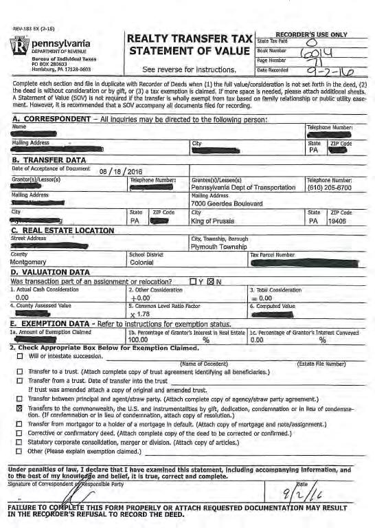
COMMONWEALTH OF PENNSYLVANIA DEPARTMENT OF TRANSPORTATION
 9 DISTRICT COUNTY TOWNSHIP ROUTE SECTION TOTAL SHEETS - FAYETTE DUNBAR 9 A R/W WBS ELEMENT T/ P SYS WO SPUR PHA SECTION ORG. PRG. P C P 7 9 A RIGHT-OF-WAY PROJECT NUMBER 9 MPMS NO 979 COMMONWEAH OF PENNSYLVANIA
B. The proposed parcel(s) of land shall be in compliance with the current zoning requirements.
 of land shall be in compliance with the current zoning requirements.") SECTION 14-900 SUBDIVISION EXEMPTION 14-901 INTENT To establish criteria and a review process whereby the Board of County Commissioners may grant Exemptions from the definition of the terms subdivision
SECTION 14-900 SUBDIVISION EXEMPTION 14-901 INTENT To establish criteria and a review process whereby the Board of County Commissioners may grant Exemptions from the definition of the terms subdivision
MOUNT OLIVE TOWNSHIP ZONING BOARD OF ADJUSTMENT VARIANCE APPLICATION INSTRUCTIONS
 MOUNT OLIVE TOWNSHIP ZONING BOARD OF ADJUSTMENT VARIANCE APPLICATION INSTRUCTIONS The completed application package, together with applicable forms and required fees, must be submitted to the Board Secretary
MUDDY CREEK TOWNSHIP PO BOX 239 PORTERSVILLE, PA SUBDIVISION AND LAND DEVELOPMENT APPLICATION
 MUDDY CREEK TOWNSHIP PO BOX 239 PORTERSVILLE, PA 16051 724-368-3438 SUBDIVISION AND LAND DEVELOPMENT APPLICATION NOTE TO ALL APPLICANTS: This checklist must be completed in its entirety If an item is not
SECTION 10 STANDARD PLATS
 SECTION 10 - STANDARD PLATS Subdivision 1: Purpose Standard Plats allow the subdivision of land into lots smaller than the minimum metes and bounds size in the zoning district, and control road development
2018 EASEMENT DEDICATION PACKET
 2018 EASEMENT DEDICATION PACKET (INCLUDES PARCELS OF LAND, EASEMENTS, AND RIGHTS-OF-WAY FOR PUBLIC USE) Information Packet There are various situations in which easements, rights-of-way, and parcels of
CITY OF SARALAND PRELIMINARY SUBDIVISION PLAT REVIEW
 PRELIMINARY SUBDIVISION PLAT REVIEW Application Number: Date Plat Submitted: Name of Subdivision: Name of Owner: Owner Address: (Street or P.O. Box) Telephone #: (City) (State) (Zip) E-mail: Name of Authorized
A Final Plat will be reviewed concurrently with any other development review application(s) that is required.
 that is required.") RELATED FACTS TO KNOW: Adams County Recording Requirements, Annexation, Common Wall Subdivision, Development Plan (PUD Development Permit), Fees, Helpful Contact Information, Lot Line Adjustment, Neighborhood
RELATED FACTS TO KNOW: Adams County Recording Requirements, Annexation, Common Wall Subdivision, Development Plan (PUD Development Permit), Fees, Helpful Contact Information, Lot Line Adjustment, Neighborhood
WYANDOT COUNTY BASIC STANDARDS FOR THE APPROVAL OF REAL ESTATE DEED TRANSFERS & LAND CONTRACT AGREEMENTS
 GENERAL In compliance with Section 315.251 of the Ohio Revised Code, the County Auditor and the County Engineer have adopted these written standards governing the conveyance of real property in Wyandot
Lake County Planning, Building and Development Department
 SUBMISSION CHECKLIST FOR SUBDIVISION FINAL PLAT Lake County Planning, Building and Development Department 500 W. Winchester Rd. Unit 101 Libertyville, Illinois 60048-1331 Telephone (847) 377-2600 E-mail:
Request for Action form is also defined as an application to be considered by the Planning Commission.
 CITY OF NORTH RIDGEVILLE INSTRUCTIONS FOR FILING REQUEST FOR ACTION APPLICATIONS WITH THE PLANNING COMMISSION (Please read the full instruction as it will help in providing a full complete application)
BOROUGH OF JESSUP SUBDIVISION AND LAND DEVELOPMENT ORDINANCE
 BOROUGH OF JESSUP SUBDIVISION AND LAND DEVELOPMENT ORDINANCE 1993 Amended May 1995 Reenacted May 2000 Amended February 9, 2004 Amended May 7, 2007 SUBDIVISION AND LAND DEVELOPMENT ORDINANCE BOROUGH OF
TOWN OF WATERVILLE VALLEY NEW HAMPSHIRE SITE PLAN REVIEW REGULATIONS
 TOWN OF WATERVILLE VALLEY NEW HAMPSHIRE Effective date March 17, 1981 Revised March 16, 1982 Revised March 13, 1986 Revised March 10, 1987 Revised March 14, 2013 Revised March 8, 2016 TOWN OF WATERVILLE
Chapter 22. Subdivision and Land Development
 Chapter 22 Subdivision and Land Development Part 1 Short Title, Authority and Purpose 22-101. Short Title 22-102. General Legislative Authority 22-103. Activities to Be Regulated 22-104. Exemptions from
GUIDELINES. RESIDENTIAL ENTRANCES To COUNTY ROADS
 GUIDELINES For RESIDENTIAL ENTRANCES To COUNTY ROADS Dept. of Public Works Roads Division 0 TABLE OF CONTENTS INTRODUCTION 2 REGULATIONS 1.0 General Policy 3 2.0 Procedure For Obtaining An Entrance Permit
MINOR SUBDIVISION FINAL PLAT APPLICATION Town of Apex, North Carolina
 MINOR SUBDIVISION FINAL PLAT APPLICATION Town of Apex, North Carolina This document is a public record under the North Carolina Public Records Act and may be published on the Town s website or disclosed
Upper Bern Township, Berks County, Pennsylvania Street Occupancy Permit Application
 Upper Bern Township, Berks County, Pennsylvania Street Occupancy Permit Application Name of Project Name of Street Nearest Intersection Name of Applicant Name of Record Owner Name of Contractor Name of
MASTER SUBDIVISION FINAL PLAT APPLICATION Town of Apex, North Carolina
 MASTER SUBDIVISION FINAL PLAT APPLICATION Town of Apex, North Carolina This document is a public record under the North Carolina Public Records Act and may be published to the Town s website or disclosed
Guide to Combined Preliminary and Final Plats
 Guide to Combined Preliminary and Final Plats Introduction The Douglas County is committed to providing open, transparent application processes to the public. This Guide is provided to assist anyone interested
APPLICATION FOR PLAN OF SUBDIVISION/CONDOMINIUM
 The Corporation of the County of Wellington APPLICATION FOR PLAN OF SUBDIVISION/CONDOMINIUM Please review the following application guidelines PRE-CONSULTATION: The County of Wellington strongly encourages
Preliminary Subdivision Application (Minor) (Three (3) lots or less)
 (Three (3) lots or less)") Gunnison City Offices www.gunnisoncity.org 38 West Center Gunnison, Utah 84634 (435) 528 7969 Date of Application: Preliminary Subdivision Application (Minor) (Three (3) lots or less) APPLICANT INFORMATION
Gunnison City Offices www.gunnisoncity.org 38 West Center Gunnison, Utah 84634 (435) 528 7969 Date of Application: Preliminary Subdivision Application (Minor) (Three (3) lots or less) APPLICANT INFORMATION
SUBMITTAL REQUIREMENTS: The number indicates the number of copies for submittal (if applicable).
.") Office Use Only Preliminary Long Plat Long Subdivision Applicant Checklist PLANNING, COMMUNITY, & ECONOMIC DEVELOPMENT DEPARTMENT PRELIMINARY LONG PLAT LONG SUBDIVISION CHECKLIST Mailing Address: P.O.
Office Use Only Preliminary Long Plat Long Subdivision Applicant Checklist PLANNING, COMMUNITY, & ECONOMIC DEVELOPMENT DEPARTMENT PRELIMINARY LONG PLAT LONG SUBDIVISION CHECKLIST Mailing Address: P.O.
MAJOR SUBDIVISION APPLICATION
 Revised 2.26.18 The Department is here to assist you with your development application pursuant to the Community Development Code (CDC). This publication outlines the Major Subdivision Development Application
WSSC EASEMENT PREPARATION AND SUBMITTAL GUIDELINES
 WSSC EASEMENT PREPARATION AND SUBMITTAL GUIDELINES PREPARED BY THE LAND SERVICES SECTION ENGINEERING AND ENVIRONMENTAL SERVICES DIVISION UPDATED SEPTEMBER, 2017 Page 1 TABLE OF CONTENTS TABLE OF CONTENTS...
DIVISION 2 - CONSTRUCTION PLAN AND MISCELLANEOUS REQUIREMENTS
 DIVISION 2 - CONSTRUCTION PLAN AND MISCELLANEOUS REQUIREMENTS 2.1 Required Plan Sheets 2.2 Drawing Requirements 2.3 Graphic Standards 2.4 Easements 2.5 Utility Locations 2.6 Private Facility Locations
Final Plat Approval of a Major Subdivision Application Packet
 Final Plat Approval of a Major Subdivision Application Packet 1. Application Packet. Be sure to complete and submit all the required materials that are a part of this Application Packet. Failure to do
Oakland County Michigan Register of Deeds Plat Engineering, GIS, & Remonumentation Dept. Ph: (248) Fax (248)
 Fax (248)") Oakland County Michigan Register of Deeds Plat Engineering, GIS, & Remonumentation Dept. Ph: (248)-858-1447 Fax (248)-858-7466 Requirements Needed for Final Plat Approval No. General Requirements. 1 Routing
Oakland County Michigan Register of Deeds Plat Engineering, GIS, & Remonumentation Dept. Ph: (248)-858-1447 Fax (248)-858-7466 Requirements Needed for Final Plat Approval No. General Requirements. 1 Routing
PARCEL MAP CHECK ENG
 Engineering Division 201 North Broadway, Escondido, CA 92025 (760) 839-4651, FAX (760) 839-4597 PARCEL MAP CHECK ENG To: Date: Project: Site Address Check No. Attn: Via: The attached plans have been reviewed
Standards for All Instruments of Conveyance
 Standards for All Instruments of Conveyance Perry County, Ohio Effective Date: May 1, 1997 Effective Date of Revision: April 1, 2011 Page 2 of 12 Minimum Standards for all Instruments of Conveyance Perry
FINAL SITE PLAN PLAT APPLICATION Town of Apex, North Carolina
 FINAL SITE PLAN PLAT APPLICATION Town of Apex, North Carolina This document is a public record under the North Carolina Public Records Act and may be published on the Town s website or disclosed to third
UPPER MOUNT BETHEL TOWNSHIP, NORTHAMPTON COUNTY, PA MINOR SUBDIVISION FINAL PLAN CHECKLIST* YES** NO
 UPPER MOUNT BETHEL TOWNSHIP, NORTHAMPTON COUNTY, PA MINOR SUBDIVISION FINAL PLAN CHECKLIST* YES** NO GENERAL SUBMISSION ITEMS Does the submission include: 1. Seven (7) copies of completed Application Form?
APPLICATION PROCEDURES FOR A PLAT AMENDMENT OR REVISION
 APPLICATION PROCEDURES FOR A PLAT AMENDMENT OR REVISION DEFINITION: Any revision or amendment to an approved recorded or unrecorded final plat. A revision (not recorded) does not require a public hearing
FINAL MAP PLAN CHECK
 Engineering Division 201 North Broadway, Escondido, CA 92025 (760) 839-4651, FAX (760) 839-4597 FINAL MAP PLAN CHECK To: Date: Project: Address: Check No: Attn: VIA: The attached FINAL MAP has been reviewed
Currituck County Phone: Planning and Community Development Fax: Courthouse Road, Suite 110 Currituck, NC 27929
 Review Process Contact Information Submit Application Determination of Completeness Staff Report (optional) Planning Director Decision Notice of Decision Recordation Minor Subdivision Currituck County
Plats and subdivisions; mapping requirements. (a) Size Requirements. All land plats presented to the register of deeds for recording in the
 Size Requirements. All land plats presented to the register of deeds for recording in the") 47-30. Plats and subdivisions; mapping requirements. (a) Size Requirements. All land plats presented to the register of deeds for recording in the registry of a county in North Carolina after September
47-30. Plats and subdivisions; mapping requirements. (a) Size Requirements. All land plats presented to the register of deeds for recording in the registry of a county in North Carolina after September
SUBDIVISION APPLICATION
 SUBDIVISION APPLICATION Preliminary Plat Minor Plat Final Plat Amended Plat Applicant Name: Owner (if different from applicant) Name: Company: Company: Address: Address: City, State, Zip City, State, Zip
A.3. ARTICLE 7 PLAN REQUIREMENTS FOR MINOR SUBDIVISION AND/OR LAND DEVELOPMENT
 700. 701.A.3. ARTICLE 7 PLAN REQUIREMENTS FOR MINOR SUBDIVISION AND/OR LAND DEVELOPMENT SECTION 700 PURPOSE The purpose of this Article is to set forth a streamlined set of Plan Requirements for minor
TENTATIVE MAP APPLICATION GUIDE (BCC 20-1)( 20-2 to )( to 20-91)( to )
( 20-2 to )( to 20-91)( to )") Butte County Department of Development Services PERMIT CENTER 7 County Center Drive, Oroville, CA 95965 Planning Division Phone 530.552.3701 Fax 530.538.7785 Email dsplanning@buttecounty.net FORM NO PLG-05
Butte County Department of Development Services PERMIT CENTER 7 County Center Drive, Oroville, CA 95965 Planning Division Phone 530.552.3701 Fax 530.538.7785 Email dsplanning@buttecounty.net FORM NO PLG-05
HARLINGEN IRRIGATION DISTRICT REQUIREMENTS FOR SUBDIVISION PLAT APPROVAL
 HARLINGEN IRRIGATION DISTRICT REQUIREMENTS FOR SUBDIVISION PLAT APPROVAL Administrative Requirements 1. All assessments and outstanding invoices associated with the property to be subdivided must be current.
CHAPTER 26 PLANNING AND ZONING ARTICLE VII. MOBILE HOMES AND RECREATIONAL VEHICLE (RV) PARKS. Recreational Vehicle (RV) Park Development Standards
 PARKS. Recreational Vehicle (RV) Park Development Standards") CHAPTER 26 PLANNING AND ZONING ARTICLE VII. MOBILE HOMES AND RECREATIONAL VEHICLE (RV) PARKS. Section 26-VII-1. Section 26-VII-2. Section 26-VII-3. Section 26-VII-4. Section 26-VII-5. Purpose Permitted
CHAPTER 26 PLANNING AND ZONING ARTICLE VII. MOBILE HOMES AND RECREATIONAL VEHICLE (RV) PARKS. Section 26-VII-1. Section 26-VII-2. Section 26-VII-3. Section 26-VII-4. Section 26-VII-5. Purpose Permitted
PLANNING BOARD CITY OF CONCORD, NH MINOR SUBDIVISION CHECKLIST
 PLANNING BOARD CITY OF CONCORD, NH MINOR SUBDIVISION CHECKLIST Summary This checklist is intended to assist applicants and design professionals in the preparation of minor subdivision applications for
MnDOT Contract No Exhibit B. Scope of Work. Scope of Work
 MnDOT Contract No. 1032993 Contract General Description The purpose of this contract is to provide the State with the survey accurate re-establishment of designated Public Land Survey section boundaries
ARTICLE 900 PLAT AND PLAN REQUIREMENTS
 ARTICLE 900 PLAT AND PLAN REQUIREMENTS SEC. 900.1 ITEMS TO BE SHOWN ON PLAT OR PLAN General (1) Property lines of all property owners adjacent to the exterior boundaries of the project shall be located
Medical Marijuana Special Exception Use Information
 Medical Marijuana Special Exception Use Information The Special Exception Use information below is a modified version of the Unified Development Code. It clarifies the current section 5:104 Special Exceptions
New Electronic Planning Commission Submittal Process
 New Electronic Planning Commission Submittal Process STANDARD OPERATING PROCEDURE Purpose: To outline the electronic submittal process for applications to the Planning Commission. Background: Procedure:
Sketch Plan 2018 Bargersville Plan Commission Application Kit
 Sketch Plan 2018 Bargersville Plan Commission Application Kit For Commercial, Industrial, and Residential Developments At least 31 days prior to the intended filing of the Primary Plat or Development Plan
MINOR SUBDIVISION APPLICATION
 Planning and Development 510 N. Baker St. Mount Dora, FL 32757 352-735-7112 Fax: 352-735-7191 plandev@cityofmountdora.com Date: Project Name: MINOR SUBDIVISION APPLICATION 1. Applicant s Name: 2. Property
TOWN OF ROXBURY PLANNING BOARD
 UPDATED: APRIL 2011 TOWN OF ROXBURY PLANNING BOARD Applicant s Guide for Subdivision Review The Town Planning Board administers the subdivision review process. This guide has been prepared in order to
Secondary Plat 2018 Bargersville Plan Commission Application Kit
 Secondary Plat 2018 Bargersville Plan Commission Application Kit For Commercial, Industrial, and Residential Subdivisions Step 1: Application The applicant must make an appointment with the Town Planner
Township of Little Egg Harbor Planning Board 665 Radio Road Little Egg Harbor, New Jersey Phone: ext. 221 Fax:
 BLOCK(S) LOT(S) Township of Little Egg Harbor Planning Board 665 Radio Road Little Egg Harbor, New Jersey 08087 Phone: 609-296-7241 ext. 221 Fax: 609-294-3040 Development Application Amended Development
Change In The Name Of Owner (s) Of Land.
 Of Land.") Clermont County TRANSFER AND CONVEYANCE STANDARDS OF THE CLERMONT COUNTY AUDITOR AND THE CLERMONT COUNTY ENGINEER AS ADOPTED UNDER OHIO REVISED CODE SECTION 319.203, AS A RESULT OF TWO PUBLIC HEARINGS
Clermont County TRANSFER AND CONVEYANCE STANDARDS OF THE CLERMONT COUNTY AUDITOR AND THE CLERMONT COUNTY ENGINEER AS ADOPTED UNDER OHIO REVISED CODE SECTION 319.203, AS A RESULT OF TWO PUBLIC HEARINGS
LAND DEVELOPMENT CHECKLIST GREEN TREE BOROUGH Green Tree Planning Commission 10 West Manilla Avenue Pittsburgh, PA
 TO BE COMPLETED BY BOROUGH: LAND DEVELOPMENT CHECKLIST GREEN TREE BOROUGH Green Tree Planning Commission 10 West Manilla Avenue Pittsburgh, PA 15220 412-921-1110 SP - - DATE STAMP RECEIVED NOTE TO ALL
CR_2017 Page 1 of 5. Corner Records
 CR_2017 Page 1 of 5 Corner Records Corner Record Check List Santa Barbara County Surveyor s Office (Examination in accordance with the PLS Act and Board Rule 464) Document No.: CR Agency Index: APN Review
Gates County Planning and Zoning
 Gates County Planning and Zoning PO Box 411, 200 Court Street, Gatesville, NC 27938 phone: 252-357-2411 fax: 252-357-0073 Application for Technical Review Committee For Staff Use Only: Date: Application
Preliminary Subdivision Application (Major) (Four (4) lots or more)
 (Four (4) lots or more)") Gunnison City Offices www.gunnisoncity.org 38 West Center Gunnison, Utah 84634 (435) 528 7969 Date of Application: Preliminary Subdivision Application (Major) (Four (4) lots or more) APPLICANT INFORMATION
Gunnison City Offices www.gunnisoncity.org 38 West Center Gunnison, Utah 84634 (435) 528 7969 Date of Application: Preliminary Subdivision Application (Major) (Four (4) lots or more) APPLICANT INFORMATION