Hi-tech Survey Operation using Modern Technologies: Concept & Process Flow
|
|
|
- Jemima Richards
- 5 years ago
- Views:
Transcription

1 Hi-tech Survey Operation using Modern Technologies: Concept & Process Flow Presented by Sri Biswaranjan Rath Asst. Director,CLR Board of Revenue, Odisha
2 Limitations of present system of surveying Survey operations are not regular- gap between records and field reality Associated with human errors Out dated method- Low level of accuracy Areas above 10 degree slope can not be surveyed Time consuming- gap between measurement taken and final output Maps in paper form- difficulty in updation
3 Need of Re-survey Mis-match between the land records data and the actual ground condition with efflux of time. Non-updation of cadastral maps reflecting the changes in land use/rights. Geographical factors such as change in course of rivers and streams and submergence/ resurgence of land. Loss of records due to negligence or natural causes.
4 Advantages of re-survey using modern technologies Maximum use of machines-errors due to human factors in survey and map preparation are negated Availability of modern techniques which are more accurate, less time consuming and cost effective. Coordinate based ground control points- no fear of misplacement. Final output in digital form- further updation will be easier.
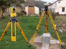
5 Methodologies Pure ground method using ETS & DGPS. Hybrid method using Aerial Photography and ground truthing by ETS & DGPS. Hybrid method using High Resolution Satellite Imagery and ground truthing by ETS & DGPS.
6 Steps for undertaking Hi-tech survey operation using Hybrid methodology
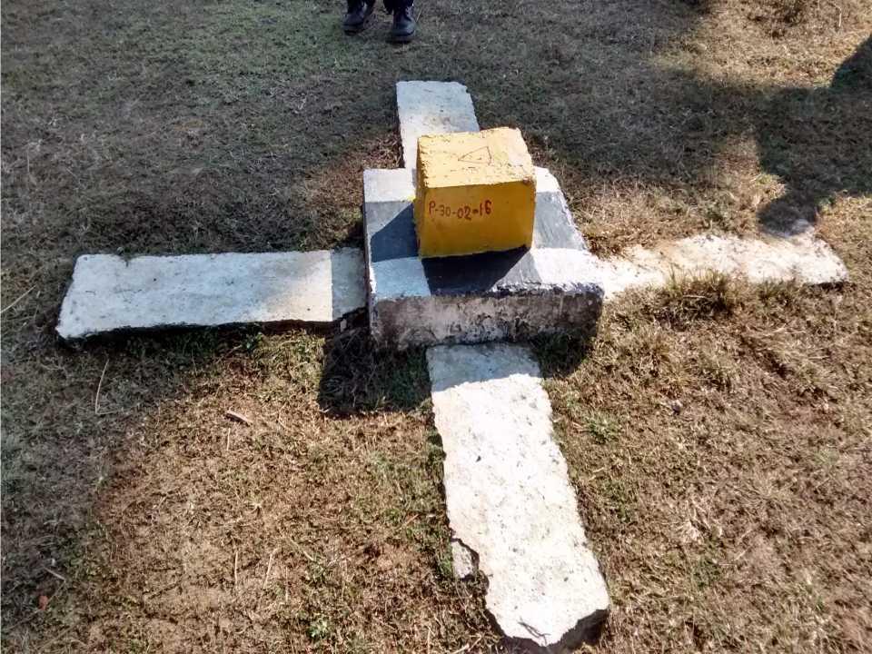
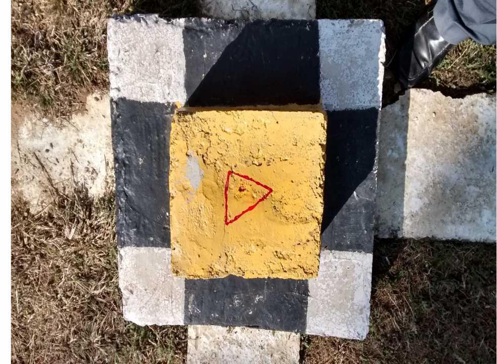
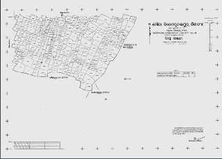
7 Establishment of Ground Control Point Network Primary GCPs- 16 km x 16 km Secondary GCPs- 4 km x 4 km Tertiary GCPS- 1 km x 1 km Primary and Secondary GCPs have permanent value and hence need to be preserved. Revenue field officers at Grass root level ( all RIs and all Tahasildars) need to be familiarizes themselves with those GCPs. The local people must be taken into confidence for their proper preservation in future. In case of any dislocation of those GCPs, the same need to be re-errected immediately.
8
9
10
11 Acquisition of Stereo Satellite Data/ Aerial Photographs Satellite data need to be procured from National Remote Sensing Agency, Hyderabad. In other case the aerial photographs need to be taken by low flying aircrafts loaded with GPS and high resolution camera. Raw image need to be converted into Ortho-image.

12
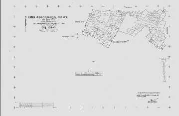
13 Geo-referencing of mosaiced digital cadastral sheets Existing cadastral sheets need to be digitized and mosaiced. The digitized cadastral map sheets need to be made available to the vendor. The vendor will use the digitized cadastral map for delineation of village boundaries on ortho-image


14 SCANNED CDASTRAL SHEETS OF A VILLAGE

15 Mosaicing of digitized sheets
16 Delineation & Confirmation of Village Boundary on Orthoimage Digitization of existing cadastral maps i Identification of Bijunction/Trijunction Points / prominent features on the digitized cadastral maps Collection of DGPS Based Point Coordinates & identification of Permanent features on the Ortho-image Superimposing digitized cadastral maps on the Ortho-image and Geo-referencing Transfer of Village Boundary to Orthoimage Selection of Boundary Plots & Marking of Village boundary Delineation of Village Boundary & adjustment if necessary Confirmation of Village Boundary


17 Delineation & Confirmation of Village Boundary on Orthoimage Identification of Bijunction & Trijunction points on ground & image. Identification of boundary plots and selection of outer limits to generate village boundary
18 Comparison of village area of cadastral map, ortho-image and RoR data Maximum tolerable limit 2% between different sources of village area For the purpose, RoR data should be up to date In case of variation (above 2% tolerable limit) field survey is necessary for boundary demarcation. Field survey is necessary if the village boundary falls under obscure areas or incase large scale variation in the village boundaries. The area obtained from filed survey will be treated as final
19 Digitization of parcels from ortho-image and identification of obscure areas The vendor shall undertake digitization of individual parcels and features on mirror principle as clearly visible in the ortho image. The parcels on records of the Government departments shall be delineated based on the existing cadastral sheets and shall be frozen. The vendor shall identify plots under obscure areas and shall submit to ORSAC for authentication. The plot wise authenticated obscure areas of each village shall be made available with DLR&S who will transmit the same to district collector for onwards transmission to the Tahasildar concerned


20 Plot Level Vectorisation and Map Generation from Ortho Image Vectorisation of plots by onscreen digitisation method using Autocad
21 Identification of obscured areas on the orthoimage Obscured areas Obscured areas PLOT VECTOR EXTRACTED FROM IMAGE


22 DIFFICULT/PROBLEM AREAS ENCOUNTERED DURING PLOT LEVEL VECTORISATION FROM ORTHO IMAGE PLOT BOUNDARY UNDER GROOVES VILLAGE BOUNDARY OBSCURED AREAS ON URBAN FRINGE WTH PLOTTING SETTELMENT/HABITATION AREAS CONSTRUCTION SITES CORNER VERTICES OBSCURED
23 Vegetated Area

24 Plot Vertices/Nodes Obscured by Tree

25 Plot Boundary not Clear
26 Plot Boundary not Clear in Habitation Areas
27 Validation of image derived parcel vectors Random selection of 5% of plots clearly visible in image and digitized by the vendor. Field measurement of dimensions of those plots and comparison with corresponding image derived dimensions Fresh look at digitization of all parcels if measurement variation will be beyond 20 cm. Repetition of the process till desired level of accuracy is achieved
28 Pre-Survey activities Notification of villages to be covered under Hi-tech survey operation by Revenue & DM Department Planning and execution of awareness meetings at village level associating the vendor Proclamation in Form No.1 by Tahasildar under Section-3 (2) of OSS&S Act, 2012 Soliciting self-declaration in Form-2 from the land owners Rule 6 (1) of OSS&S Rules, 2012 within 30 working days from the date of notification Verification of self-declaration by Tahasildar/ Additional Tahasildar and preparation of verification certificate in Form-3
29 Survey Planning All Gharabari (Habitation) areas, obscured areas, interstate boundaries, village boundaries difficult to interpret from ortho-image and 5% randomly selected image derived plot shall be put to DGPS/ETS survey. Vendor must submit its manpower and equipment resources for to District Administration for appropriate planning Detail Tahasil wise survey schedule in Form No. 1 (T) with approval of Collector for publication at District/ Tahasil and village level. Village wise survey schedule in Form No. 2 (T) must be notified in the concerned village at least 10 days before commencement of survey. Involvement of local people and local officials of land owning departments must be there.
30 Execution of DGPS/ETS survey Each survey team should comprise at least one surveyor and one assistant surveyor. Survey team is to be assisted by one Amin/ARI of local Tahasil and land owners of the programmed village during survey. Local officials of other land owning departments may help the survey agencies in identification of boundaries of land parcels owned by those departments. All survey should be done with reference to nearby GCP. Auxillary point if necessary can be taken the co-ordinate of which should be provided to DLR&S. Ghrabari areas must be surveyed section wise and in each section survey should start and end in one control point The plot wise survey schedule has to be authenticated by the concerned Tahasildar before integration of survey vectors to the map.


31 Plot Level Map Generation after Integration of field survey data VECTOR FROM IMAGE VECTOR FROM FIELD


32 Linking of Existing RoR & Addition/Updation of RoR Through Tenant Interaction/ Data Collection from Tahasil Office

33 Plot Vector Extracted from Image with Plot Number from RoR/cadastral maps

34 Comparison of Plot Area those of Image derived and RoR AREA OF PLOT AS RECORDED IN ROR AREA OF PLOT MAPPED FROM IMAGE
35 Preparation of preliminary RoR Submission of map so prepared by the vendor to Tahasildar for verification indicating plot numbers of existing map/ror and a comparative statement of image derived parcel area with RoR area in Form 6-T Constitution of team of persons by Sub-Collector for preparation of Preliminary RoR headed by a Revenue Supervisor Preparation of abstract of RoR and plot register in Form-5 & 6 Re-verification of self-declarations with reference to above abstract and plot register and available records
36 Physical verification of all plots and noting of all changes in respect of configuration, area, boundaries and ownerships Sub-divided plots need to be marked in broken lines Team of persons must ensure incorporation of all plots in existing RoR and those obtained from self declarations in the draft map so prepared Vendor personnel shall assist the team of persons in demarcation of plots during the process Digital updation of village map upto a cut-off date i.e. till publication of draft RoR by Tahasildar
37 Preparation of land owner wise preliminary RoR in Form-7 Generation of LPM of hal plots and serving of same to land owners and officers of other Departments in Form-4(T) with display for public scrutiny for 15 days Soliciting claims and objections within 15 days in Form-8 Disposal of all claims and objections by Tahasildar in a summary manner within a maximum period of 30 working days of receipt of the same ( Rule-10) The vendor surveyor shall assist the Tahasildar for disposal of objection cases which may require parcel measurement

38 A4 SIZE MAP GENERATION FOR TENANT INTERACTION


39 Grievance Hearing by Tahasildar and RoR/ Map Finalization BOUNDARY DISPUTE CLEARANCE DEMARCATION OF GOVT. PROPERTY SINGLE PLOT NOT TWO SINGLE PLOT NOT TWO ROR CORRECTION BOUNDARY UNDER CANOPY COVER SINGLE PLOT NOT TWO ONE PART UNDER WATERING NO SUBDIVISION SINGLE OWNER
40 Draft Record of Rights Draft RoR shall be prepared in Form-12 stating the orders passed in respect of claims and objections and shall be published for a period of 30 days (Rule-12) Issuance of public notice in Form-13 inviting claims and objections within a period of 30 days Disposal of claims and objections in a summary manner by Addl. Sub-Collector on the basis of available records, documentary evidence and spot verification if needed within 60 days of filing of such claims/objections
41 Recess Addition and alterations in the draft RoR per the orders passed by Addl. Sub-Collector Addition and alterations in the draft RoR per the orders passed by Addl. Sub-Collector Checking and verification of area of each plot and area and boundaries of each revenue village to ensure its correctness both in RoR and in maps. Passing of new area by Tahasildar Preparation of abstract of new RoR in Form-18 and new plot Register in Form-19 Preparation of copies of RoR in quadruplicates for final publication
42 Final Record of Rights Final RoR will be published in Form-20 under seal and signature of Collector and shall be placed for public inspection for 30 days Both soft & hard copies shall be prepared by the vendor for distribution among land owner,ri, Tahasildar, Collector and DLR&S Any person can file claim/objection against the entries of final RoR within 90 days of publication of final RoR before the ADM Disposal of claims and objections in a summary manner by ADM on the basis of available records, documentary evidence and spot verification if needed within 90 days of filing of such claims/objections
43 Quality Checking by ORSAC After geo-referencing of existing cadastral maps with image for delineation of village boundary After plot vector generation and prior to ground truthing: geometry of parcels and village boundary Before submission of draft map to Tahasildar for verification after ground truthing: village in completeness correctness of matched/ mis-matched plots as identified by the vendor after linkage of RoR Before submission of final RoR after khanapuri operation,dispute resolution : vector database,map composition and GIS database
44 Challenges Involvement of private parties in survey operations. Different from traditional methods of survey. Technologies are new to revenue field functionaries. Participation and acceptance of general public is necessary.
45 Supports and assistance Odisha Special Survey & Settlement Act, 2012 and corresponding Rules Technical Manual for cadastral survey using modern technologies Executive Instructions to be issued by Govt./ DLR&S, Odisha Manuals for manner of recording Govt. land and private land during survey operations State level Technical Committee for advice and doubt clearance Revenue & DM Department for further clarification


46 Thank you
PROJECT REPORT. Submitted To : Submitted by. Deputy Director Revenue Officer Training Institute
 PROJECT REPORT TOPIC: DIFFERENCE BETWEEN HITECH SURVEY AND TRADITIONAL SURVEY HOW IS HI-TECH SURVEY BEING CONDUCTED. ROLE OF REVENUE OFFICIALS IN VERIFICATION, VALIDATION, AND PREPARATION OF ROR AND MAPS
MASS REGISTRATION OF LAND PARCELS USING FIT-FOR-PURPOSE LAND ADMINISTRATION: PROCEDURES AND METHODS
 MASS REGISTRATION OF LAND PARCELS USING FIT-FOR-PURPOSE LAND ADMINISTRATION: PROCEDURES AND METHODS TAREK ZEIN Hansa Luftbild AG, Germany zein@hansaluftbild.de Paper prepared for presentation at the 2017
New Models for Property Data Verification and Valuation
 New Models for Property Data Verification and Valuation for 2006 IAAO Councils and Sections Joint Seminar May 9-11, 2006 Charleston, South Carolina Presented by George Donatello, CMS Principal Consultant
General Instructions For Surveys and Plans Outside the Provincial Survey System
 May 15, 2018 General Instructions For Surveys and Plans Outside the Provincial Survey System NOTE: This document is a Controller of Surveys Policy manual to be used as a general guideline for the Legal
Field surveying inspection using tablets
 Field surveying inspection using tablets Rami Farraj, Ahmad Sghyyer Survey of Israel, Lincoln 1, Tel-Aviv, Israel rami@mapi.gov.il ahmad@mapi.gov.il Key words: Field Surveying, Cadastre, Mapping Procedures
Jack McKenna, Director of Business Development, Africa and the Caribbean
 Presented at the FIG Working Week 2016, May 2-6, 2016 in Christchurch, New Zealand Jack McKenna, Director of Business Development, Africa and the Caribbean FIG WORKING WEEK 2016 Fit for Purpose Parcel
PROJECT INFORMATION DOCUMENT (PID) CONCEPT STAGE Report No.: AB3229 Project Name. Land Registry and Cadastre Modernization Project Region
 CONCEPT STAGE Report No.: AB3229 Project Name. Land Registry and Cadastre Modernization Project Region") PROJECT INFORMATION DOCUMENT (PID) CONCEPT STAGE Report No.: AB3229 Project Name Land Registry and Cadastre Modernization Project Region EUROPE AND CENTRAL ASIA Sector Central government administration
PROJECT INFORMATION DOCUMENT (PID) CONCEPT STAGE Report No.: AB3229 Project Name Land Registry and Cadastre Modernization Project Region EUROPE AND CENTRAL ASIA Sector Central government administration
QUESTIONNAIRE. 1. Authorizing statute(s) citation West Virginia Code and 11-1C-4(d)
 citation West Virginia Code and 11-1C-4(d)") QUESTIONNAIRE (Please include a copy of this form with each filing of your rule: Notice of Public Hearing or Comment Period; Proposed Rule, and if needed, Emergency and Modified Rule.) DATE: 6/8/15 TO:
QUESTIONNAIRE (Please include a copy of this form with each filing of your rule: Notice of Public Hearing or Comment Period; Proposed Rule, and if needed, Emergency and Modified Rule.) DATE: 6/8/15 TO:
By: Barney I. S. Laseko Programme Coordinator Prime Minister s Office TANZANIA
 2014 CONFERENCE ON LAND POLICY IN AFRICA 11 14 NOVEMBER, 2014 Focussed Discussion VIII Converting from Manual Land Registration to GIS Enabled Land Information System Case of Sub Saharan Africa Tanzania
e-cadastre and Photo-Interpretation Technologies
 UNECE- WPLA EFFICIENT AND TRANSPARENT LAND MANAGEMENT IN ECE COUNTRIES 4 March 2010 - Baku, Azerbaijan e-cadastre and Photo-Interpretation Technologies The Italian experience as an example of Good Practice
CENTRAL MINE PLANNING & DESIGN INSTITUTE LIMITED
 Information Brochure and Application Form for Empanelment of Firms for Development of Web GIS based Cadastral Level Land Information System (LIS) & Land Acquisition Monitoring System (LAMS) for Coal Mining
Alternatives for Economic Boundary Determination in the Establishment of a Cadastral System. Paper to the FIG Working Week 2012 Rome, May 9, 2012
 Alternatives for Economic Boundary Determination in the Establishment of a Cadastral System Paper to the FIG Working Week 2012 Rome, May 9, 2012 by Gottfried Konecny Emeritus Professor Leibniz University
COUNTY GOVERNMENT OF LAMU Department of Land, Physical Planning, Infrastructure & Urban Development
 1 COUNTY GOVERNMENT OF LAMU Department of Land, Physical Planning, Infrastructure & Urban Development TERMS OF REFERENCE FOR OUTSOURCING OF CONSULTANCY SERVICES FOR SURVEY & REGULARIZATION OF KATSAIKAIKAIRU
Quality Improvement to Cadastral Information in Sweden
 Gunnar BLIXT, Sweden Key words: digital cadastre, quality, cadastral index map, real property register. SUMMARY Lantmäteriet is a governmental agency which gives support for creating an efficient and sustainable
Replies to Queries of the Bidders
 Date: 07.12.2018 Replies to Queries of the Bidders SUB: Replies to queries of the bidders against Tender for carrying out survey works, opening of ROU & Manmad in Nashik GA to Dhule GA (approx. 300 km)
Presented by: Stewart Information International, Inc. Jack McKenna
 Presented by: Stewart Information International, Inc. Jack McKenna Held at the: 2007 ESRI Survey & Engineering GIS Summit San Diego Convention Center San Diego, California June 16-19, 2007 Integrating
A Geocoded Cadastral Fabric as a Precondition for a Sustainable Land Management System
 A Geocoded Fabric as a Precondition for a Sustainable Land Management System Gottfried KONECNY, Germany; J.P. LAUZON, Canada; Abdul Salam MOHAMMED, India Key words: SDI,, Parcel Boundaries, GPS-GNSS, Land
Responsible and Innovative Land Administration
 Responsible and Innovative Land Administration An Example from Ethiopia 3 RD DECEMBER 2018 Outline A few words about NIRAS Fit-for-purpose: A low-tech disruptive approach? The REILA Project in Ethiopia
City of Surrey s Digital Plan Submission Process
 City of Surrey s Digital Plan Submission Process Cadastral Update Karen Stewart, B.Tech. (GIS) Spatial Information Manager Peter Mueller, B.C.L.S., C.L.S. Survey Manager City of Surrey, British Columbia,
RFP for QC Tool. Document Control Sheet. Name of the Organisation StockHolding Document Management Services Ltd
 Document Control Sheet Name of the Organisation StockHolding Document Management Services Ltd RFP Reference No. SDMS/IT/08/01 Date of issue of RFP Document 26 th August 2016 Pre-bid Meeting 2 th September
INDIAN INSTITUTE OF TECHNOLOGY ROORKEE. Presentation on REAL TIME CADASTRAL SURVEYING SOLUTION WITH A SPECIAL IMPHESIS TO MODERN GPS TECHNOLOGY.
 INDIAN INSTITUTE OF TECHNOLOGY ROORKEE Presentation on REAL TIME CADASTRAL SURVEYING SOLUTION WITH A SPECIAL IMPHESIS TO MODERN GPS TECHNOLOGY By: Prof. Kamal Jain, Dept. of Civil Engg. IIT-Roorkee AIM
Cadastral Information System of Sofia
 Alexander LAZAROV and Hristo DECHEV, Bulgaria Key words: ABSTRACT A new Cadastre and Property Register Act (CPRA) was passed in April 2000, setting up rules for the maintenance of these two registers.
2001, A GIS SJ,'ATIALODDESSY. James G. Donahue, L.S. PBS&J,Inc Alton Parkway Irvine, CA 92714
 POSTER SESSIONS 13 2001, A GIS SJ,'ATIALODDESSY James G. Donahue, L.S. PBS&J,Inc. 2501 Alton Parkway Irvine, CA 92714 Biographical Sketch James G. Donahue is a licensed land surveyor in private practice.
Land Records Modernisation. Good Practices & Gaps. Policy Brief
 Land Records Modernisation Good Practices & Gaps Policy Brief LAND RECORD MODERNISATION: GOOD PRACTICES & GAPS Subject LRM : Ownership ALL/ RURAL URBAN, PERI-URBAN Good Practice Gap Good Practice Gap LAND
(Website: Ministry of Rural Development Government of India
 Department of Land Resources (Website: www.dolr.nic.in) Ministry of Rural Development Government of India 1 Computerization of Land Records Three Centrally Sponsored Schemes (CSS) : Strengthening of Revenue
Land Administration in Jordan
 Land Administration in Jordan Problems and Challenges Eng. Director of Registration Services Department of Lands & Survey q General information q Historical Background q Properties Initiation q Problems
1. A portion of the cost to the public body for obtaining the original or copies of the documents, printouts or photographs.
 39-121.03. Request for copies, printouts or photographs; statement of purpose; commercial purpose as abuse of public record; determination by governor; civil penalty; definition A. When a person requests
The Survey Data Model Technology A practical survey solution to generate all levels of spatial and e-governance outcomes.
 Land Governance in a Rapidly Changing Environment Annual World Bank Conference on Land and Poverty April 24 & 25, 2012 The Survey Data Model Technology A practical survey solution to generate all levels
Standards of Practice for Surveying in the State of Alabama
 Standards of Practice for Surveying in the State of Alabama Effective January 1, 2017 RULE NO. 1.01 PURPOSE The purpose of these rules is to establish standards for the practice of surveying in the State
REQUEST FOR PROPOSAL (RFP) RFP AS. Appraisal Services Valuation of DBHA Properties
 RFP AS. Appraisal Services Valuation of DBHA Properties") REQUEST FOR PROPOSAL (RFP) RFP 2019-01AS Appraisal Services Valuation of DBHA Properties Daytona Beach Housing Authority (DBHA) 211 N Ridgewood Ave Suite 300 Daytona Beach, FL 32114 (386) 253-5653 Terril
REQUEST FOR PROPOSAL (RFP) RFP 2019-01AS Appraisal Services Valuation of DBHA Properties Daytona Beach Housing Authority (DBHA) 211 N Ridgewood Ave Suite 300 Daytona Beach, FL 32114 (386) 253-5653 Terril
Reforming the Land Sector in Jamaica
 Silburn CLARKE and Llewelyn ALLEN, Jamaica Key words: tenure, cadastre, land reform, adjudication, public awareness, land titling, GPS, parcel mapping, traversing, land legislation, tenure regularisation,
Ownership Data in Cadastral Information System of Sofia (CIS Sofia) from the Available Cadastral Map
 from the Available Cadastral Map") Ownership Data in Cadastral Information System of Sofia (CIS Sofia) from the Available Cadastral Map Key words: ABSTRACT Lydmila LAZAROVA, Bulgaria CIS Sofia is created and maintained by GIS Sofia ltd,
Ownership Data in Cadastral Information System of Sofia (CIS Sofia) from the Available Cadastral Map Key words: ABSTRACT Lydmila LAZAROVA, Bulgaria CIS Sofia is created and maintained by GIS Sofia ltd,
Lower Rio Grande Valley Development Council. Invitation to Bid (ITB): Graphic Design Training Services. office. 301 West Railroad Weslaco, Texas 78596
: Graphic Design Training Services. office. 301 West Railroad Weslaco, Texas 78596") The Lower Rio Grande Valley Development Council (LRGVDC) Invitation to Bid (ITB): Graphic Design Training Services. Quotes Due Not Later than: Issuing Office: Friday, July 15th, 2016 at 12:00 Noon at the
The Lower Rio Grande Valley Development Council (LRGVDC) Invitation to Bid (ITB): Graphic Design Training Services. Quotes Due Not Later than: Issuing Office: Friday, July 15th, 2016 at 12:00 Noon at the
BULGARIAN CADASTRE A GUARANTEE FOR THE OWNERSHIP RIGHTS IN IMMOVABLE PROPERTIES
 4 TH INTERNATIONAL CONFERENCE RECENT PROBLEMS IN GEODESY AND RELATED FIELDS WITH INTERNATIONAL IMPORTANCE February 28 - March 2, 2007, Inter Expo Centre, Sofia, Bulgaria BULGARIAN CADASTRE A GUARANTEE
REVENUE OFFICER S TRAINING INSTITUTE (ROTI) Project Report on
 Project Report on") REVENUE OFFICER S TRAINING INSTITUTE (ROTI) Project Report on Conversion of Agricultural land for non-agricultural purpose under 8-A of OLR Act 1960- A Boon or Bane? & Upto date instructions issued by
REVENUE OFFICER S TRAINING INSTITUTE (ROTI) Project Report on Conversion of Agricultural land for non-agricultural purpose under 8-A of OLR Act 1960- A Boon or Bane? & Upto date instructions issued by
A Vision for a Fully Digital Cadastral Survey System
 A Vision for a Fully Digital Cadastral Survey System Anselm HAANEN, Trent GULLIVER, New Zealand Key words: cadastral survey system, digital cadastre, survey plans SUMMARY Surveyors have traditionally prepared
DI-LRMP Impact Assessment Synthesis
 DI-LRMP Impact Assessment Synthesis Report Release Devendra B Gupta, Deepak Sanan & Prerna Prabhakar November 13, 2017 Outline of Impact Assessment State level status (for each state) Tehsil level Assessment
RESIDENTIAL PROPERTY VALUATION PROCESS
 RESIDENTIAL PROPERTY VALUATION PROCESS Introduction Gregg County is comprised of approximately 276 square miles of area. Gregg County Appraisal District (GCAD) is responsible for the appraisal of the approximately
Revised Tax Map Rules
 Revised Tax Map Rules PVC Subcommittee Committee Report October 3, 2013 Prepared by: Kurt Donaldson Manager WV GIS Technical Center West Virginia University Phone: (304) 293-9467 kdonalds@wvu.edu Contents
Hybrid Cadastre Pilot Project Guidelines for Public Land Disposition Surveys Operations Division
 Hybrid Cadastre Pilot Project Guidelines Operations Division January 12, 2015 Version Update Version No. Date Summary of Changes 2.0 January 12, Table of Contents 2015 Table of Contents added to Guidelines.
UPPER MOUNT BETHEL TOWNSHIP NORTHAMPTON COUNTY, PENNSYLVANIA
 UPPER MOUNT BETHEL TOWNSHIP NORTHAMPTON COUNTY, PENNSYLVANIA JOINDER DEED / LOT CONSOLIDATION TOWNSHIP REVIEW PROCESS When accepting proposed Joinder Deeds / Lot Consolidations, review the Joinder Deed
ABSTRACT Land Administration System in Lithuania
 ABSTRACT Land Administration System in Lithuania 1. General introduction to the Lithuanian Land Administration System and State Enterprise Centre of Registers ( shortly SECR) Lithuania has established
Section I General Information
 General Information Table of Contents A. Introduction... I-2 1. Purpose... I-2 2. Scope... I-2 3. Maintenance... I-3 4. Units... I-3 B. Public Relations... I-3 1. General Public... I-3 2. Property Owners...
MnDOT Contract No Exhibit B. Scope of Work. Scope of Work
 MnDOT Contract No. 1032993 Contract General Description The purpose of this contract is to provide the State with the survey accurate re-establishment of designated Public Land Survey section boundaries
FLORIDA DEPARTMENT OF ENVIRONMENTAL PROTECTION
 FLORIDA DEPARTMENT OF ENVIRONMENTAL PROTECTION NOTICE OF INTENT TO USE S. 403.9327, F.S., GENERAL PERMIT FOR MANGROVE TRIMMING OR APPLICATION FOR S. 403.9328, F.S., INDIVIDUAL PERMIT TO TRIM OR ALTER MANGROVES
A Method For Building Legal Digital Cadastre Without Using Cadastral Measurements Field Book Data Is It Accurate Enough?
 A Method For Building Legal Digital Cadastre Without Using Cadastral Measurements Field Book Data Is It Jad JARROUSH, Dmitri BRICKMAN, Israel Key words: Digital Cadastre, Least Squares Cadastral Computations,
Progress Report on Green Paper. Dr. Paddy Prendergast. on behalf of the. IIS Commission on Land Registration
 Progress Report on Green Paper By Dr. Paddy Prendergast on behalf of the IIS Commission on Land Registration Paddy Prendergast - Chair Brendan Sweeny - Hempenstall Surveys Paul Corrigan - P Corrigan Associates
250 CMR: BOARD OF REGISTRATION OF PROFESSIONAL ENGINEERS AND LAND SURVEYORS DRAFT FOR DISCUSSION PURPOSES ONLY
 250 CMR 6.00: LAND SURVEYING PROCEDURES AND STANDARDS Section 6.01: Elements Common to All Survey Works 6.02: Survey Works of Lines Affecting Property Rights All land surveying work is considered work
Performance, Audit and Review Group Strategy and Plans
 AUDIT OF KEY FINANCIAL PROCESSES AT WATERTON LAKES NATIONAL PARK FIELD UNIT FINAL REPORT June 23, 2003 Prepared by: PARAGON Review and Consulting Inc. Performance, Audit and Review Group Strategy and Plans
Integration of Phodi process with Mutation in Bhoomi (Simultaneous updation of Spatial & Textual LR)
") Integration of Phodi process with Mutation in Bhoomi (Simultaneous updation of Spatial & Textual LR) Presented by Sri S.M.Jaamdar Principal Secretary to Government of Karnataka Revenue Department Activities
Integration of Phodi process with Mutation in Bhoomi (Simultaneous updation of Spatial & Textual LR) Presented by Sri S.M.Jaamdar Principal Secretary to Government of Karnataka Revenue Department Activities
WYOMING DEPARTMENT OF REVENUE CHAPTER 7 PROPERTY TAX VALUATION METHODOLOGY AND ASSESSMENT (DEPARTMENT ASSESSMENTS)
") CHAPTER 7 PROPERTY TAX VALUATION METHODOLOGY AND ASSESSMENT (DEPARTMENT ASSESSMENTS) Section 1. Authority. These Rules are promulgated under the authority of W.S. 39-11-102(b). Section 2. Purpose of Rules.
CHAPTER 7 PROPERTY TAX VALUATION METHODOLOGY AND ASSESSMENT (DEPARTMENT ASSESSMENTS) Section 1. Authority. These Rules are promulgated under the authority of W.S. 39-11-102(b). Section 2. Purpose of Rules.
Technology-driven solutions for the innovation of land administration and management
 Technology-driven solutions for the innovation of land administration and management Technology and economic growth - Studies*find link between technology innovation and national economic prosperity especially,
Lower Rio Grande Valley Development Council. Hidalgo County Metropolitan Planning organization (HCMPO) Invitation to Bid (ITB):
 Invitation to Bid (ITB):") The Lower Rio Grande Valley Development Council (LRGVDC) Hidalgo County Metropolitan Planning organization (HCMPO) Invitation to Bid (ITB): Thirty (30) IPads with Accessories Quotes Due Not Later than:
The Lower Rio Grande Valley Development Council (LRGVDC) Hidalgo County Metropolitan Planning organization (HCMPO) Invitation to Bid (ITB): Thirty (30) IPads with Accessories Quotes Due Not Later than:
Camp Central Appraisal District LEGAL AND ADMINISTRATIVE REQUIREMENTS
 Camp Central Appraisal District LEGAL AND ADMINISTRATIVE REQUIREMENTS Counties are responsible for creating and establishing an Appraisal District. As a political subdivision of the state the major responsibility
Table of Contents. Appraiser Independence Policy Forms
 Table of Contents Table of Contents... 1 Appraiser Independence... 2 Policies Applicable to All Company Operating Areas... 2 Appraiser Selection and Approval... 3 Appraiser Approval Process... 3 Approved
The Boundary and the Effects of Cadastral Surveying in Cyprus
 The Boundary and the Effects of Cadastral Surveying in Cyprus Aristi Louca, Margarita Fani Surveyor Engineers, Cyprus Association of Rural and Surveying Engineers The History of Cyprus goes back 11000
etender for Selection of Agency for Generation of Resurvey Maps in 33 Districts of Bihar
 etender for Selection of Agency for Generation of Resurvey Maps in 33 Districts of Bihar Directorate of Land Records & Surveys Department of Revenue & Land Reforms Main Secretariat, Patna (Bihar) PIN Code
Criteria for Appeals of Flood Insurance Rate Maps. November 30, 201 1
 Criteria for Appeals of Flood Insurance Rate Maps November 30, 201 1 This document outlines the criteria for appealing proposed changes in flood hazard information on Flood Insurance Rate Maps (FIRMS)
CLICK HERE TO KNOW MORE
 CLICK HERE TO KNOW MORE LANDS AND SURVEYS DEPARTMENT SABAH, MALAYSIA GEO-CADASTRE IN LAND ADMINISTRATION: SABAH S EXPERIENCE Sr Hj SAFAR B UNTONG, FISM, MRICS Director, Lands & Surveys Department Sabah,
Upgrading and Land Titling in Informal Settlements. Manica City
 Expert Group Meeting on secure land tenure: 'new legal frameworks and tools' November10-12 2004, UNGigiri in Nairobi, Kenya Upgrading and Land Titling in Informal Settlements Manica City MANICA PROVINCE,
FROM RESIDENTIAL LICENSES TO FULL TITLE IN TANZANIA
 FORMALISATION OF LANDED PROPERTIES IN UNPLANNED SETTLEMENTS FROM RESIDENTIAL LICENSES TO FULL TITLE IN TANZANIA by Sarah A. Kyessi, Assistant Director Settlements Regularisation Ministry of Lands Housing
RULES OF THE GEORGIA STATE BOARD OF REGISTRATION FOR PROFESSIONAL ENGINEERS AND LAND SURVEYORS CHAPTER APPLICATIONS TABLE OF CONTENTS
 RULES OF THE GEORGIA STATE BOARD OF REGISTRATION FOR PROFESSIONAL ENGINEERS AND LAND SURVEYORS CHAPTER 180-7 APPLICATIONS TABLE OF CONTENTS 180-7-.07 Maps and Plats. All maps, plats and similar documents
Map Modernization Modernization Program
 FEMA Map Modernization Program Presented to Maryland Association of Floodplain and Stormwater Managers October 27, 2005 Map Modernization Program Autorun.exe 2 Map Modernization Program Outline Map Mod
COASTAL DEVELOPMENT PERMIT APPLICATION
 COUNTY OF MENDOCINO DEPARTMENT OF PLANNING AND BUILDING SERVICES 501 Low Gap Road, Room 1440 Ukiah, California 95482 Telephone 707-463-4281 FAX 707-463-5709 790 South Franklin Street Fort Bragg, California
INVESTIGATION OF TITLE & RECORD OF RIGHTS
 INVESTIGATION OF TITLE & RECORD OF RIGHTS Prepared by : KRISHMA SHAH (Associate) On Date : 14 May 2016 1 3 Main Steps prior to Purchase of property: Settlement of the terms of the deal between the parties
DAWSON COUNTY MINOR PLAT REVIEW CHECKLIST $50.00 FEE PER PLAT REVIEW, $5.00 FEE FOR SCAN & CD FOR RECORDING
 DAWSON COUNTY MINOR PLAT REVIEW CHECKLIST $50.00 FEE PER PLAT REVIEW, $5.00 FEE FOR SCAN & CD FOR RECORDING NAME ON PLAT: CONTACT/PHONE #: NAMED STREET/ADDRESS: LAND LOT: DISTRICT: SECTION: ZONING: SETBACKS:
FIG-WB Forum on Land Administration
 FIG-WB Forum on Land Administration and Reform in Sub-Sahara Africa [Nigeria] [Peter O. Adeniyi] FIG WORKING WEEK, Abuja, NIGERIA 2013-6-10 MAY 2013 Statistic Country at a Glance Total population 162,470,737
TENTATIVE PARCEL MAP APPLICATION GUIDE TENTATIVE PARCEL MAP APPLICATION REQUIREMENTS
 TENTATIVE PARCEL MAP APPLICATION GUIDE SISKIYOU COUNTY PLANNING DIVISION 806 South Main Street, Yreka CA 96097 Phone: (530) 841-2100 / Fax: (530) 841-4076 TENTATIVE PARCEL MAP APPLICATION REQUIREMENTS
International funding projects in Republic Geodetic Authority
 International funding projects in Republic Geodetic Authority Serbia: Republic Geodetic Authority Workshop Exploring Funding Instruments for NMCA 7-8 November 2012 Republic Geodetic Authority Republic
REQUEST FOR PROPOSAL RFP # TOC17-001
 REQUEST FOR PROPOSAL RFP # TOC17-001 April 25, 2017 157 NW Columbia Avenue P. O. Box 183 Chapin, SC 29036 Tel.: (803) 345-2444 Fax: (803) 345-0427 April 25, 2017 REQUEST FOR PROPOSAL RFP # TOC17-001 The
PROFESSIONAL EXPECTATIONS PLEDGE
 PROFESSIONAL EXPECTATIONS PLEDGE An optional supplement to the REALTOR Code of Ethics A. CUSTOMER CARE & COMMUNICATION Customer Care refers to the actions, attentions, and precautions through which a Subscribing
Land and Easement Donation Process and Requirements Summary
 Land and Easement Donation Process and Requirements Summary Many of the steps involved in donating land or conservation easements to American Friends of Canadian Land Trusts (AF) will be familiar to people
Spatial Data Warehouse Ltd. Cadastral Mapping INITIATIVE 1: CADASTRAL MAPPING. Version Spatial Data Warehouse Ltd. & AltaLIS Ltd.
 Spatial Data Warehouse Ltd. Initiative 1: Cadastral Mapping INITIATIVE 1: CADASTRAL MAPPING 29 P3 The SDW/AltaLIS Model Background The Government of Alberta started a mapping program, the Municipal Integrated
CADASTRAL MAPS AND GIS FOR SUSTAINABLE ECONOMIC DEVELOPMENT OF KOSOVA
 1 Title: CADASTRAL MAPS AND GIS FOR SUSTAINABLE ECONOMIC DEVELOPMENT OF KOSOVA Name and surname: E-mail: Organization: Conference Theme: Prof. Dr. sc. Murat MEHA mmeha@yahoo.com Kosovo Cadastral Agency
Request for Proposals
 Request for Proposals On Call Right-of-Way and Easement Acquisition and Related Services Requested by: Charter Township of Shelby Department of Public Works 6333 23 Mile Road Shelby Township, MI 48316
LIS Development Project and Measures Proposed to Enhance Trust in the Land Administration System in Uganda
 Project for Design, Supply, Installation and Implementation of the Land Information System and Securing of Land Records (DeSILISoR) LIS Development Project and Measures Proposed to Enhance Trust in the
201 KAR 18:150. Standards of practice.
 201 KAR 18:150. Standards of practice. RELATES TO: KRS 322.290(1)(a), (2)(f) STATUTORY AUTHORITY: KRS 322.290(2)(f) NECESSITY, FUNCTION, AND CONFORMITY: KRS 322.290(1)(a) authorizes the board to administer
Arlington County, Virginia. Internal Audit of the Real Estate Assessment Appeals Process Calendar Year Ended December 31, 2014
 Arlington County, Virginia Internal Audit of the Real Estate Assessment Appeals Process Calendar Year Ended December 31, 2014 Table of Contents Transmittal Letter... 1 Executive Summary... 2-9 Background...
MAJOR SUBDIVISION PRELIMINARY PLAT CHECKLIST
 TOWNSHIP OF EGG HARBOR PLANNING BOARD/ZONING BOARD OF ADJUSTMENT 3515 BARGAINTOWN ROAD EGG HARBOR TOWNSHIP, NJ 08234 MAJOR SUBDIVISION PRELIMINARY PLAT CHECKLIST The following checklist is designed to
ORDINANCE NO AN ORDINANCE ESTABLISHING A UNIFORM SYSTEM FOR STREET ADDRESSING IN EMERY COUNTY
 ORDINANCE NO. 21505 AN ORDINANCE ESTABLISHING A UNIFORM SYSTEM FOR STREET ADDRESSING IN EMERY COUNTY The County Commission of the County of Emery, State of Utah, being the Legislative Body of said county,
GIS and Land Records Integration A PRIA White Paper
 110 Horizon Drive, Suite 210, Raleigh, NC 27615 919.459.2081 GIS and Land Records Integration A PRIA White Paper Adopted by the PRIA Board on December 20, 2017 www.pria.us/ GIS and Land Records Integration
Letters of Map Amendment- Out as Shown
 Letters of Map Amendment- Out as Shown While digital Flood Insurance Rate Maps (DFIRM s) have made it easier to determine if a structure (or building site) is in the special flood hazard area (SFHA), many
Role of spatial planning in modern society
 Republic of Croatia State Geodetic Administration The Role of Cadastre in the Development of Regional and Local Planning Structure in Croatia Zdravko Cesarec and Željko Bačić 1 Role of spatial planning
D DAVID PUBLISHING. Mass Valuation and the Implementation Necessity of GIS (Geographic Information System) in Albania
 in Albania") Journal of Civil Engineering and Architecture 9 (2015) 1506-1512 doi: 10.17265/1934-7359/2015.12.012 D DAVID PUBLISHING Mass Valuation and the Implementation Necessity of GIS (Geographic Elfrida Shehu
Journal of Civil Engineering and Architecture 9 (2015) 1506-1512 doi: 10.17265/1934-7359/2015.12.012 D DAVID PUBLISHING Mass Valuation and the Implementation Necessity of GIS (Geographic Elfrida Shehu
PREPARING SURVEY TENDER GIS DATABASE OUTCOMES
 PREPARING SURVEY TENDER SPECIFICATIONS FOR PROJECT GIS DATABASE OUTCOMES Presentation by Ian Harper GEODATA AUSTRALIA ESRI User Conference 2009 24 st July 2009 BACKGROUND GIS databases now provide a more
A Complete, Free Solution for Cadastral Map Management
 A Complete, Free Solution for Cadastral Map Management Gyula IVÁN Institute of Geodesy, Cartography & Remote Sensing (FÖMI) HUNGARY FIG Commission 7, Annual Meeting 11-15 September 2008., Verona, ITALY
Rule 21 STANDARDS OF PRACTICE FOR SURVEYING
 Rule 21 STANDARDS OF PRACTICE FOR SURVEYING 21.1 Whenever a survey is performed, it shall comply with Section 73-13-71 (4) and Section 73-13- 73 and the Standards of Practice for Surveying in Mississippi
Italian Cadastre and Real Estate Rights and Mortgages Registration System
 CLGE General Assembly Italian Cadastre and Real Estate Rights and Mortgages Registration System Franco Maggio Central Director Cartography, Cadastre and Real Estate Rights and Mortgages Registration System
Hamilton Conservation Authority Watershed Planning and Engineering
 Hamilton Conservation Authority Watershed Planning and Engineering Plan Review Service Fees Subdivision and Condominiums Before HST After HST Minor $1,150.44 $1,300.00 Intermediate $4,601.77 $5,200.00
VARIANCE PROCEDURE The City Council will consider the request and either grant or deny the variance.
 VARIANCE PROCEDURE 1 The Minnetrista City Code was established to protect both current and future residents from the negative impacts of improper development and to ensure a positive future for the city.
Cadastral Re-Alignment: Water Corporation approach to spatial data shifting
 Cadastral Re-Alignment: Water Corporation approach to spatial data shifting David Bulfield, Team Leader Spatial Systems Team, Spatial Information Management, Water Corporation (Western Australia) Justin
REAL ESTATE CERTIFICATES. The investment instrument for real estate projects
 REAL ESTATE CERTIFICATES The investment instrument for real estate projects NOW, IT IS EASIER TO INVEST IN REAL ESTATE What is real estate certificate? It is an investment instrument structured to divide
Recognition of Prior Learning (RPL) Application NSW
 Application NSW") NSW Real Estate Training College PO Box 601, Hornsby NSW 2077 Phone: 02 9987 2322 Fax 02 9479 9720 rpl@realestatetraining.com.au www.realestatetraining.com.au Recognition of Prior Learning (RPL) Application
NSW Real Estate Training College PO Box 601, Hornsby NSW 2077 Phone: 02 9987 2322 Fax 02 9479 9720 rpl@realestatetraining.com.au www.realestatetraining.com.au Recognition of Prior Learning (RPL) Application
2018 Assessment Roll Edit Guide for Parcel-Level Geographical Information System (GIS) Information
 Information") 2018 Assessment Roll Edit Guide for Parcel-Level Geographical Information System (GIS) Information Florida Department of Revenue Property Tax Oversight January 2, 2018 Intended Users This edit guide is
2018 Assessment Roll Edit Guide for Parcel-Level Geographical Information System (GIS) Information Florida Department of Revenue Property Tax Oversight January 2, 2018 Intended Users This edit guide is
Request for Proposals For Village Assessment Services
 Request for Proposals For Village Assessment Services INQUIRIES AND PROPOSALS SHOULD BE DIRECTED TO: Jesse Thyes Village Administrator 860 Badger Circle Grafton, WI 53024 Introduction The Village of Grafton
NAGPUR IMPROVEMENT TRUST Station road, Sadar, Nagpur
 1 NAGPUR IMPROVEMENT TRUST Station road, Sadar, Nagpur 440 001 (Rs. 20 Including Sale Tax) (SPECIAL PLANNING AUTHORITY FOR NAGPUR METROPOLITAN AREA APPOINTED BY GOVT. OF MAHARASHTRA VIDE NOTIFICATON NO.
Sales Ratio: Alternative Calculation Methods
 For Discussion: Summary of proposals to amend State Board of Equalization sales ratio calculations June 3, 2010 One of the primary purposes of the sales ratio study is to measure how well assessors track
e-registration Project on Submitted by SOUMYAKANTA SOUMYADARSHI, ORS Addl. Tahasildar, DIGAPAHANDI Revenue Officer s Training Institute
 Revenue Officer s Training Institute Project on e-registration Submitted by SOUMYAKANTA SOUMYADARSHI, ORS Addl. Tahasildar, DIGAPAHANDI (15th Batch Trainee) Table of Contents 1. Introduction... 2 2. e-registration
EMPANELMENT OF ARCHITECTS CONSULTANCY FIRMS FOR STATE BANK OF INDIA, DELHI CIRCLE IN THE CATEGORY OF 1.0 CRORE AND 5.0 CRORE
 EMPANELMENT OF ARCHITECTS CONSULTANCY FIRMS FOR STATE BANK OF INDIA, DELHI CIRCLE IN THE CATEGORY OF 1.0 CRORE AND 5.0 CRORE State Bank of India invites application for the empanelment of Architectural
THE PLANTATION CORPORATION OF KERALA LTD KOTTAYAM - 4 PCK/SEC/
 THE PLANTATION CORPORATION OF KERALA LTD KOTTAYAM - 4 PCK/SEC/01 18.09.2018 E-TENDER CONDITIONS FOR THE WORK OF TOTAL STATION SURVEY OF ESTATES OF PCK. Sealed competitive e-tenders are invited for the