METHODOLOGY FOR THE DEVELOPMENT OF NATIONAL DIGITAL CADASTRAL DATABASE (NDCDB)
|
|
|
- Leo Jones
- 5 years ago
- Views:
Transcription

1 KURSUS COORDINATED CADASTRAL SYSTEM (CCS) INSTITUT TANAH & UKUR NEGARA BEHRANG, PERAK METHODOLOGY FOR THE DEVELOPMENT OF NATIONAL DIGITAL CADASTRAL DATABASE (NDCDB) OLEH: PROF DR ABD MAJID BIN A KADIR & ABDULLAH HISAM OMAR Fakulti Kejuruteraan & Sains Geoinformasi Universiti Teknologi Malaysia Skudai, Johor. majid@fksg.utm.my, a.hisham@fksg.utm.my 21 st OCTOBER 23 OVERVIEW ON PREVIOUS COORDINATED CADASTRAL SYSTEM RESEARCH PROJECTS PILOT STUDY : 1996 Pilot study has been conducted in Malaysia with the following objectives To determine the effectiveness of using Global Positioning System for cadastral control network densification To select most appropriate adjustment method for the large cadastral network FEASIBILITY STUDY: Feasibility study has been carried out in the Melaka/Johor border with the following objectives: To carry out larger cadastral network adjustment To use Rectified Skew Orthomorphic (RSO) projection system in the cadastral network adjustment To use geocentric datum (WGS84) as a National Geodetic Datum To introduce GPS measurement for cadastral application The outcome of this study are as follows : RSO projection may be used to replace Cassini for cadastral mapping purposes. Least squares adjustment technique is suitable and practical to be used in the large cadastral network adjustment Potential use of geocentric datum has been realized A guideline for using GPS in Cadastral surveying is produced It has been realized from the previous studies that Coordinated Cadastral System could potentially be implemented in Peninsular Malaysia 1


2 THE IMPORTANCE OF THE STUDY Coordinated Cadastral System (CCS) a cadastral reform programme to improve the cadastral survey system. Implementation of CCS feasible, according to results of feasibility study. Long term benefits to be accrued from CCS implementation: Utilizing Whole to the Part methodology. Facilitate use of rapid data acquisition, storage, processing & management techniques. Improvement of the cadastral survey system. Provides common reference system. Facilitate data integration. CCS basis for / underpins a good LIS. CCS UNDERPINS A GOOD LAND INFORMATION SYSTEM (LIS) Coordinate based LIS facilitate data integration process in GIS Environment 2
 (LIS) Before CCS After CCS ELIPSOID MODIFIED EVEREST")

 (LIS) Before CCS Labour Intensive After CCS One man Show")
3 CCS UNDERPINS A CCS UNDERPINS A GOOD GOOD LAND LAND INFORMATION INFORMATION SYSTEM SYSTEM (LIS) (LIS) Before CCS After CCS ELIPSOID MODIFIED EVEREST ELIPSOID WGS 84 Datum Origin: Kertau Datum Origin: Center of the Mass Data integration can be done globally Coordinated Cadastral System: System Methodology For The Development of National Digital Cadastral Database Database CCS UNDERPINS A CCS UNDERPINS A GOOD GOOD LAND LAND INFORMATION INFORMATION SYSTEM SYSTEM (LIS) (LIS) Before CCS Labour Intensive After CCS One man Show Coordinated Cadastral System: System Methodology For The Development of National Digital Cadastral Database Database 3

 Before CCS After CCS Plotting coordinates are")
4 CCS UNDERPINS A GOOD LAND INFORMATION SYSTEM (LIS) Before CCS After CCS GPS GPS Network adjustment technique: Transit /Bowditch Low accuracy and suitable for individual lot Network adjustment technique: Least Squares High accuracy and rigorous method. CCS UNDERPINS A GOOD LAND INFORMATION SYSTEM (LIS) Before CCS After CCS Plotting coordinates are not adjusted properly Adjusted coordinates 4
5 STUDY FRAMEWORK IMPLEMENTATION OF CCS TECHNICAL ISSUES Development of Geocentric Based Cadastral Control Data Base (CCDB) Development of National Digital Cadastral Data Base (NDCDB) Integration of National Digital Cadastral Data Base (NDCDB) & National Digital Topography Data Base (NDTDB) INSTITUTIONAL ISSUES Organizational Legal Economic Social Implementation of CCS TECHNICAL ISSUES MODULE A Development of Geocentric- Based CCDB CCDB MODULE C Cadastral & Topographic Intergration NDTDB SDCDB MODULE B Development of NDCDB AUTOMATED DATABASE CONVERSION SYSTEM NDCDB SDCDB - State Digital Cadastral Data Base NDCDB - National Digital Cadastral Data Base CCDB - Cadastral Control Data Base NDTDB - National Digital Topographic Data Base 5
6 COORDINATES MALAYSIAN PERCEPTION OF THE COORDINATED CADASTRE Coordinated Cadastre as a coordinate-based cadastral system with the coordinates being given legal significance. The prominance of measured bearing and distances are reduced whereby they are considered as only a means by which the final adjusted coordinates are derived. The emphasis of the concept is the earth-centered datum, a single projection system for the whole country and the application of least-square adjustment technique in the distribution of survey errors. BEARING & DISTANCE LEAST SQUARES ADJUSTMENT PROJECTION SYSTEM DATUM MODULE B: Development of A National Digital Cadastral Database CCDB ADJUSTMENT DATA INTEGRITY CHECK DATA SELECTION QUALITY CONTROL TEMP NDCDB SDCDB Input Connection Lines TRANSFORM EDITING Automated Database Conversion System NDCDB CCDB : Cadastral Control Database SDCDB : State Digital Cadastral Database NDCDB : National Digital Cadastral Database 6

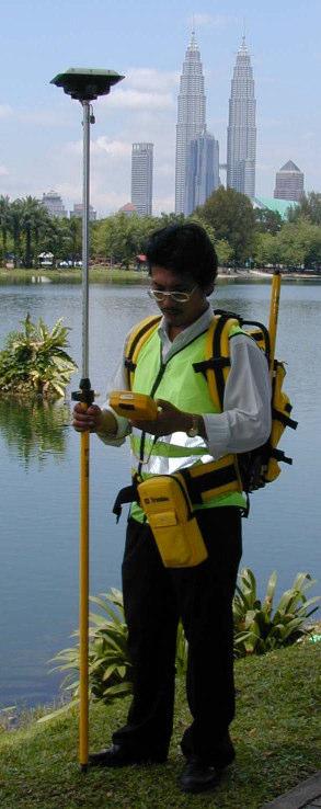
7 OBJECTIVES (Modified from original proposal) The study objectives of this module are: To assess and analyze the use of the existing State Digital Cadastral Database (DCDB) as the primary input to Coordinated Cadastral System; To develop Cadastral Control Infrastructure using GPS technology for both urban and rural areas; To develop Automated Database Conversion System for the development of National Digital Cadastral Database STUDY AREA 5 x 5 km Urban Area In Kuala Lumpur 4 x 4 km Rural & Semi Urban Area Covering Melaka & Johor States 7


8 Tmn. Eastern COORDINATED CADASTRAL SYSTEM PROJECT Study Area #1: Wilayah Persekutuan, Kuala Lumpur 5 X 5 km Tmn P.Ramlee Wilayah Persekutuan Bkt.Tunku GPS Control Station Spacing ~5m Jln. Gurney U 27,. m T 48,. m COORDINATED CADASTRAL SYSTEM PROJECT Study Area #2: Melaka Johor 4 X 4 km U 27,. m T 54,. m Ulu Kemengkang, Kesang Bkt Serampang Kg Pt Payong Parit Bakar Parit Jawa & Seri Menanti U 2,. m T 48,. m GPS Control Station Spacing ~2.5 km U 2,. m T 54,. m 8
9 Cadastral Control Infrastructure Development PHASE MELAKA REMARKS JOHOR REMARKS Reconnaissance* Mac of 132 stations have been identified Mac of 132 stations have been identified Monumentation* Mac 21 Standard Traverse, Pipe and Cadastre mark Mac 21 Standard Traverse, Pipe and Cadastre mark GPS Field Observation * 19 Mac 7 April Jasin, Melaka Tengah, Alor Gajah 7 Apr 14 April Muar GPS Processing and Results* Results Delivered: 3/5/21 * Note: Geodesy Section, JUPEM Melaka and JUPEM Johor Cont GPS Field Observation For Study Area # 2 ( Melaka Johor) GPS Network Grid consists of Primary Grid (1 kmx 1 km) Secondary Grid (2.5 km x 2.5 km Primary Grid Secondary Grid Observation Technique Static Reference Stations: M331 (Tg.Keling, Melaka), GP13 ( Tebong, Melaka), GP16 ( Pagoh, Johor) Rapid Static : Reference Stations Primary Grid Points Observation Time Total of Stations GPS Processing Software Adjustment Software 9 minutes 23 Trimble Geomatic Office V1.1 Geolab 2.4c 15-3 minutes 197 Trimble Geomatic Office V1.1 Trimble Geomatic Office V1.1 9

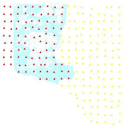
10 GPS Network Grid For Study Area # 2: Melaka Primary Grid Secondary Grid 1

11 Cadastral Control Infrastructure For Study Area # 2 11


12 Cadastral Control Database (CCDB) Overlay and Identify Stages DCDB CCDB Identify GPS Control Stations in Cadastral Database (DCDB) 12

13 PREPARATION OF DATA INPUT & CONNECTION LINES DIGITAL CADASTRAL DATABASE FOR STUDY AREA # 1: WILAYAH PERSEKUTUAN KUALA LUMPUR GPS.shp Wp1lot.shp Wp1bboundary.shp Lot.shp 13


14 Total of Connection Lines: 289 Total of Connection Lines:


15 CADASTRAL INFRASTRUCTURE FOR STUDY AREA # 1: WILAYAH PERSEKUTUAN KUALA LUMPUR Connection-line-b.shp Kl-connectionline e-a.shp GPS.shp Wp1lot.shp Wp1lotbboundary.shp Lot.hp Bdy.shp PREPARATION OF DATA INPUT: MELAKA Completed In-progress 15


16 Total of Connection Lines: 4951 PREPARATION OF DATA INPUT: JOHOR 16

17 AUTOMATED DATABASE CONVERSION SYSTEM 17


18 Data Selection Module Cont Selection Process Filtering Process Filtered Zone 18


19 Cont Log File: New and Current Point Keys Save to StarNet Format Samb Populasi-PDUK PDUK Original Boundary file ( Cassini coordinate only for selected boundary stones ) Interfacing program for repopulation of DCDB New attribute: Two new columns: RSO_EAST & RSO_North and Cassini coordinate 19
20 ADJUSTMENT OF TEST AREAS: i)melaka -Johor ii) Wilayah Persekutuan Kuala Lumpur Statistical Summary for Adjustment: WGS-MRT-RSO-CASSINI CASE 1 (Fixed GPS Control Point at 2.5 km Interval) GPS Control Station: , , , 53PA3141, 23PA192, 5PA1315 MAX MIN MEAN RMS Bearing Residual Distance (m) Stn.Coord Std.Deviations N (m) E (m) Statistical Summary for adjustment Block 4-42 Number of Stations : 4954 Error Factor : (Standard error factor = 1.) Distance for max bearing residual : m Distance for min bearing residual : m 2
 GPS Control Station:9312653, 114385, 712653, 53PA3141, 23PA192, 5PA1315 Bearing 1 56-1 59 Residual Distance (m).39 -.4.3 Stn.Coord Std.Deviations N (m).92.41 21.7.42 Statistical Summary for adjustment Block 4-42 E (m).")
21 Error Ellipse for Adjustment: Local Cassini CASE 1 Ellipse Scale: 15 Statistical Summary for Adjustment: WGS-CASSINI (GEOCENTRIC) CASE 2 MAX MIN MEAN RMS (Fixed GPS Control Point at 2.5 km Interval) GPS Control Station: , , , 53PA3141, 23PA192, 5PA1315 Bearing Residual Distance (m) Stn.Coord Std.Deviations N (m) Statistical Summary for adjustment Block 4-42 E (m) Number of Stations : 4954 Error Factor : (Standard error factor = 1.) Distance for max bearing residual : m Distance for min bearing residual : m 21


22 CASE 2 Error Ellipse for Adjustment: Geocentric Cassini Ellipse Scale: 15 Database COMBINED ADJUSTMENT RESULTS OF MELAKA CADASTRAL NETWORK Total of Adjusted Boundary Marks: Coordinated Cadastral System: System Methodology For The Development of National Digital Cadastral Database Database 22
23 Statistics of the Melaka CCS Adjustment Blk No. Blk 1-6 Blk 7-8 Blk Blk Blk 17 Blk 18 Blk 2-27 Blk 3 Blk Blk Blk 4-42 Blk 43 Blk 45 Blk 47 No. of Stn No. of Obs No. of Unknowns No. of Redundant Obs No. of GPS Stn Error Factor Note : Standard error factor is 1. Comparison Between Two Difference Cassini System BEARING RESIDUALS Blk 1-6 Blk 7-8 Blk Blk Blk 17 Blk 18 Blk 2-27 Blk 3 Blk Blk Blk 4-42 Blk 43 Blk 45 Blk 47 MAX GEODETIC MIN MEAN RMS MAX GEOCENTRIC MIN MEAN 1 1 RMS
24 Comparison Between Two Difference Cassini System DISTANCE RESIDUALS Blk 1-6 Blk 7-8 Blk Blk Blk 17 Blk 18 Blk 2-27 Blk 3 Blk Blk Blk 4-42 Blk 43 Blk 45 Blk 47 MAX GEODETIC MIN MEAN RMS MAX GEOCENTRIC MIN MEAN RMS Comparison Between Two Difference Cassini System STATION COORDINATE STANDARD DEVIATIONS NORTH/SOUTH COMPONENT Blk 1-6 Blk 7-8 Blk Blk Blk 17 Blk 18 Blk 2-27 Blk 3 Blk Blk Blk 4-42 Blk 43 Blk 45 Blk 47 MAX GEODETIC MIN MEAN RMS MAX GEOCENTRIC MIN MEAN RMS
25 Comparison Between Two Difference Cassini System STATION COORDINATE STANDARD DEVIATIONS EAST/WEST COMPONENT Blk 1-6 Blk 7-8 Blk Blk Blk 17 Blk 18 Blk 2-27 Blk 3 Blk Blk Blk 4-42 Blk 43 Blk 45 Blk47 MAX GEODETIC MIN MEAN RMS MAX GEOCENTRIC MIN MEAN RMS Statistical Summary For W.P.K.L Adjustments Results (Control Stations at 5 m spacing) 25

 4-4 7 4-4 1")
26 Error Ellipse for Block 1 K.L in Local Cassini System Error Ellipse for Block 1 K.L in Geocentric Cassini System Comparison of Adjustment Statistics Between 2.5 km and.5 km Control Spacing (Geocentric Case) 2.5 km GPS Control.5 km GPS Control MAX MIN MEAN RMS MAX MIN MEAN RMS Bearing Distance (mm) Std. Dev. N/S (mm) Std. Dev. E/W (mm)
27 SUMMARY Data screening and cleaning is essential since outliers exist in the data input. Manual editing is needed in order to run the adjustment ~ time consuming, tedious and challenging task. Data selection and Adjustment process greatly depend on the cleanliness of the data input. For the implementation of CCS, the adjustment progresses coherently with Outliers encountered during adjustment process The availability of number of software license The adjustment results depend on several factors: I) Control station ii) Accuracy of the cadastral survey iii) Block size iv) Number of boundary mark v) Density of the cadastral lot Adjustment results show that the residuals and standard deviations for bearing, distance and coordinate are in tolerance. GPS station at.5km and 2.5km spacing are sufficient to be used in providing control for urban and rural cadastral networks, respectively. RECOMMENDATIONS To develop a comprehensive data integrity and management module in the existing Cadastral Management System comprising: Revision of DCDB development process especially during data entry. The creation of new layer in the DCDB for Cadastral Control and Connection Line To establish Cadastral Control Infrastructure with the following consideration: GPS control in a grid format for better network geometry during adjustment process. GPS station at.5km and 2.5 km spacing are sufficient to be used in providing control for urban and rural cadastral networks, repestively. To facilitate the current GPS technologies such as Real-Time Kinematic GPS and Virtual GPS reference System in the Cadastral Control Infrastructure development process To further refine the present Automated Database Conversion System To restructure boundary mark file in order to populate the DCDB with new adjusted survey accurate coordinates 27
")
28 IMPACT OF GDM2 ON CCS IMPLEMENTATION (Technical Views) Basic CCS Implementation Model for Peninsular Malaysia ( Modified Version) 28
 Development of A National Digital Cadastral Database (Modified From")
29 Establishing the State Cadastral Control Infrastructure (CCI) & State Cadastral Control Database (Modified From Original Conceptual Model) GDM 2 Designing CCI Network Monumentatio n GPS Surveys Processing Geocentric Cassini / RSO Coordinates of Control Points & site identifications STATE Cadastral Control Database (CCDB) Development of A National Digital Cadastral Database (Modified From Original Conceptual Model) CCDB : Cadastral Control Database SDCDB : State Digital Cadastral Database NDCDB : National Digital Cadastral Database 29
SCOPE OF PRESENTATION
 INTERNATIONAL SYMPOSIUM AND EXHIBITION ON GEOINFORMATION Global Trends: Geoinformation For The New Economy Studies Toward the Development of Implementation Plan Of Coordinated Cadastral System for Peninsular
CURRENT TREND IN GEOINFORMATION TECHNOLOGY INTRODUCTION
 CURRENT TREND IN GEOINFORMATION TECHNOLOGY STUDIES TOWARD THE DEVELOPMENT OF IMPLEMENTATION PLAN OF COORDINATED CADASTRAL SYSTEM FOR MALAYSIA Abd. Majid A. Kadir, Shahrum Ses, Ghazali Desa, Kamalludin
PRESENTATION SUMMARY
 COORDINATED CADASTRAL SYSTEM FOR PENINSULAR MALAYSIA: FROM CONCEPT TO REALITY by: Professor Dr. Abd. Majid A. Kadir Associate Professor Ghazali Desa PMP Dr. Abdullah Hisam Omar Faculty of Geoinformation
CADASTRE SURVEY PRACTICE (SGHU 4323)
") CADASTRE SURVEY PRACTICE (SGHU 4323) WEEK 11-eCADASTRE SR DR. TAN LIAT CHOON 07-5530844 016-4975551 1 OUTLINE Coordinated Cadastral System National Digital Cadastral Database Multipurpose Cadastre 3D Cadastre
CADASTRE SURVEY PRACTICE (SGHU 4323) WEEK 11-eCADASTRE SR DR. TAN LIAT CHOON 07-5530844 016-4975551 1 OUTLINE Coordinated Cadastral System National Digital Cadastral Database Multipurpose Cadastre 3D Cadastre
Developing Infrastructure Framework To Facilitate The Malaysia Multipurpose 3D Cadastre
 Developing Infrastructure Framework To Facilitate The Malaysia Multipurpose 3D Cadastre Sr Dr. Tan Liat Choon Sr Looi Kam Seng University of Technology Malaysia Department of Survey and mapping Malaysia
CADASTRAL STUDIES (MGU1014 / MGHU1514)
") CADASTRAL STUDIES (MGU1014 / MGHU1514) WEEK 10-eCADASTRE SYSTEM AND MULTIPURPOSE CADASTRE SR DR. TAN LIAT CHOON 07-5530844 016-4975551 1 OUTLINE ecadastre System Multipurpose Cadastre 2 ecadastre SYSTEM
CADASTRAL STUDIES (MGU1014 / MGHU1514) WEEK 10-eCADASTRE SYSTEM AND MULTIPURPOSE CADASTRE SR DR. TAN LIAT CHOON 07-5530844 016-4975551 1 OUTLINE ecadastre System Multipurpose Cadastre 2 ecadastre SYSTEM
FIG-WB Forum on Land Administration and reform in Sub-Sahara Africa
 FIG-WB Forum on Land Administration and reform in Sub-Sahara Africa Chris Mnyanga Ministry of Lands UNITED REPUBLIC OF TANZANIA] FIG WORKING WEEK, Abuja, NIGERIA 2013-6-10 MAY 2013 Country at Glance UNITED
CADASTRAL STUDIES (MGU1014 / MGHU1514)
") CADASTRAL STUDIES (MGU1014 / MGHU1514) WEEK 8-LAW AND REGULATIONS (FIELD) SR DR. TAN LIAT CHOON 07-5530844 016-4975551 1 OUTLINE Field Survey Practice 2 FIELD SURVEY PRACTICE 3 Survey Datum For new survey
CADASTRAL STUDIES (MGU1014 / MGHU1514) WEEK 8-LAW AND REGULATIONS (FIELD) SR DR. TAN LIAT CHOON 07-5530844 016-4975551 1 OUTLINE Field Survey Practice 2 FIELD SURVEY PRACTICE 3 Survey Datum For new survey
A Radical Solution for the Cadastre Problem in Egypt Using Integrated GPS-GIS System
 A Radical Solution for the Cadastre Problem in Egypt Using Integrated GPS-GIS System Dr. Ehab NABIL NASSIF, Egypt Key words: ABSTRACT During the period 1897-1907 the cadastral surveying of Egypt was established.
EKADASTER: A LEARNING EXPERIENCE FOR MALAYSIA
 EKADASTER: A LEARNING EXPERIENCE FOR MALAYSIA Mohd Yunus MOHD YUSOFF, Hasan JAMIL, Nur Zurairah ABDUL HALIM, Nor Ashikin MOHAMED YUSOF and Mohammad Azmi MOHD ZAIN, Malaysia Keywords: ekadaster, Cadastral
Section I General Information
 General Information Table of Contents A. Introduction... I-2 1. Purpose... I-2 2. Scope... I-2 3. Maintenance... I-3 4. Units... I-3 B. Public Relations... I-3 1. General Public... I-3 2. Property Owners...
General Instructions For Surveys and Plans Outside the Provincial Survey System
 May 15, 2018 General Instructions For Surveys and Plans Outside the Provincial Survey System NOTE: This document is a Controller of Surveys Policy manual to be used as a general guideline for the Legal
The Cadastral Modelling Future and The Land Surveyors Role
 The Cadastral Modelling Future and The Land Surveyors Role Ian Harper Geodata Australia ESRI Survey Summit July 2013 The Land Surveyors Future Role From Custodians of the Cadastre to Custodians of the
Commission No : 5 RCBMS : OVERVIEW
 RFID-Based Cadastral Boundary Mark System (RCBMS Abdullah Hisam Omar Tajul Ariffin Musa Ivin Amri Musliman Siti Syukriah Khamdan Kamaludin Omar Universiti Teknologi Malaysia Email: abdullahhisham@utm.my
PREPARING SURVEY TENDER GIS DATABASE OUTCOMES
 PREPARING SURVEY TENDER SPECIFICATIONS FOR PROJECT GIS DATABASE OUTCOMES Presentation by Ian Harper GEODATA AUSTRALIA ESRI User Conference 2009 24 st July 2009 BACKGROUND GIS databases now provide a more
The Digital Cadastral Database and the Role of the Private Licensed Surveyors in Denmark
 IRISH INSTITUTE OF SURVEYORS, DUBLIN INSTITUTE OF TECHNOLOGY, 23 NOVEMBER 2005 PUBLISHED IN IIS NEWS, WINTHER 2006. The Digital Cadastral Database and the Role of the Private Licensed Surveyors in Denmark
A Method For Building Legal Digital Cadastre Without Using Cadastral Measurements Field Book Data Is It Accurate Enough?
 A Method For Building Legal Digital Cadastre Without Using Cadastral Measurements Field Book Data Is It Jad JARROUSH, Dmitri BRICKMAN, Israel Key words: Digital Cadastre, Least Squares Cadastral Computations,
15 LEGAL AND ORGANIZATIONAL ASPECTS OF MALAYSIAN 3D CADASTRE
 15 LEGAL AND ORGANIZATIONAL ASPECTS OF MALAYSIAN 3D CADASTRE Muhammad Imzan Hassan Alias Abdul Rahman Department of Geoinformatics, Faculty of Geoinformation Science and Engineering, Universiti Teknologi
A Geocoded Cadastral Fabric as a Precondition for a Sustainable Land Management System
 A Geocoded Fabric as a Precondition for a Sustainable Land Management System Gottfried KONECNY, Germany; J.P. LAUZON, Canada; Abdul Salam MOHAMMED, India Key words: SDI,, Parcel Boundaries, GPS-GNSS, Land
Hybrid Cadastre Pilot Project Guidelines for Public Land Disposition Surveys Operations Division
 Hybrid Cadastre Pilot Project Guidelines Operations Division January 12, 2015 Version Update Version No. Date Summary of Changes 2.0 January 12, Table of Contents 2015 Table of Contents added to Guidelines.
Field surveying inspection using tablets
 Field surveying inspection using tablets Rami Farraj, Ahmad Sghyyer Survey of Israel, Lincoln 1, Tel-Aviv, Israel rami@mapi.gov.il ahmad@mapi.gov.il Key words: Field Surveying, Cadastre, Mapping Procedures
The New Technology of a Survey Data Model and Cadastral Fabric as the Foundation for a Future Land Administration System.
 The New Technology of a Survey Data Model and Cadastral Fabric as the Foundation for a Future Land Ian HARPER, Australia Key words: cadastral modelling, survey data model, Survey Accuracy, Cadastre 2014
Status Report. Contents
 Working Group 4 (Cadastre and Land Management) Status Report 17 October, 2016 Kuala Lumpur, Malaysia Chair Prof. BG Lee, Republic of Korea Vice Chair Mr. Ali Bakar Kasim, Brunei Darussalam Mr. Zhao Yousong,
BULGARIAN CADASTRE A GUARANTEE FOR THE OWNERSHIP RIGHTS IN IMMOVABLE PROPERTIES
 4 TH INTERNATIONAL CONFERENCE RECENT PROBLEMS IN GEODESY AND RELATED FIELDS WITH INTERNATIONAL IMPORTANCE February 28 - March 2, 2007, Inter Expo Centre, Sofia, Bulgaria BULGARIAN CADASTRE A GUARANTEE
The Survey Data Model Technology A practical survey solution to generate all levels of spatial and e-governance outcomes.
 Land Governance in a Rapidly Changing Environment Annual World Bank Conference on Land and Poverty April 24 & 25, 2012 The Survey Data Model Technology A practical survey solution to generate all levels
Cadastre: definitions
 Introduction New vision towards a multipurpose cadastral system to support land management in Morocco Moha EL-AYACHI, El Hassane SEMLALI, Mohamed ETTARID, Driss TAHIRI, Institut Agronomique et Vétérinaire
The creation of a Survey Accurate Cadastral Map for surveyed areas in Trinidad & Tobago
 The creation of a Survey Accurate Cadastral Map for surveyed areas in Trinidad & Tobago Anesh Gopee, Keith Miller and Charisse Griffith Charles University of the West Indies Trinidad aneshtt@yahoo.com
Tidal Datum Consistency for Marine Cadastre Littoral Zone Commencement in Malaysia
 Tidal Datum Consistency for Marine Cadastre Littoral Zone Commencement in Malaysia Rasheila Rahibulsadri, Abdullah Hisam Omar, Ashraf Abdullah, Wan Muhammad Aizzat Wan Azhar, Chan Keat Lim, Teng Chee Hua,
Topographic Signs Important Context of 3D Cadastre
 STATE GEODETIC ADMINISTRATION Gruška 20,10 000 Zagreb, Croatia Delft University of Technology Faculty of Architecture and the Built Environment Department OTB GIS Technology Section Topographic Signs Important
COORDINATED CADASTRES - A KEY TO BUILDING FUTURE GIS
 Proceedings of the Regional Conference on Managing Geographic Information Systems for Success, Melbourne, 3-4 July, pp.60-69 (1996). COORDINATED CADASTRES - A KEY TO BUILDING FUTURE GIS Ian P.Williamson
PROJECT INFORMATION DOCUMENT (PID) CONCEPT STAGE Report No.: AB3229 Project Name. Land Registry and Cadastre Modernization Project Region
 CONCEPT STAGE Report No.: AB3229 Project Name. Land Registry and Cadastre Modernization Project Region") PROJECT INFORMATION DOCUMENT (PID) CONCEPT STAGE Report No.: AB3229 Project Name Land Registry and Cadastre Modernization Project Region EUROPE AND CENTRAL ASIA Sector Central government administration
PROJECT INFORMATION DOCUMENT (PID) CONCEPT STAGE Report No.: AB3229 Project Name Land Registry and Cadastre Modernization Project Region EUROPE AND CENTRAL ASIA Sector Central government administration
Problems and Solution Proposals in Integration of Cadastral Data into Geographical Information System (GIS) in Turkey
 in Turkey") Problems and Solution Proposals in Integration of Cadastral Data into Geographical Information System (GIS) in Turkey Gülgün OZKAN, S. Savas DURDURAN, Ali ERDI and Bilal GIRGIN, Turkey Key words: Cadastre,
Problems and Solution Proposals in Integration of Cadastral Data into Geographical Information System (GIS) in Turkey Gülgün OZKAN, S. Savas DURDURAN, Ali ERDI and Bilal GIRGIN, Turkey Key words: Cadastre,
The Integration of CORS Networks and the Cadastre and its Application in NSW, Australia
 The Integration of CORS Networks and the Cadastre and its Application in NSW, Australia Jai REDDY, Australia Key words: digital cadastre, CORS, GNSS, cadastral system SUMMARY In many countries, CORS networks
The Economy and the Housing Market. By: Dr. Zulkiply Omar Senior Research Fellow Malaysian Institute of Economic Research (MIER)
") The Economy and the Housing Market By: Dr. Zulkiply Omar Senior Research Fellow Malaysian Institute of Economic Research (MIER) The Malaysian Economy Add a footer 2 The World Economy GDP Growth (% y-o-y)
The Economy and the Housing Market By: Dr. Zulkiply Omar Senior Research Fellow Malaysian Institute of Economic Research (MIER) The Malaysian Economy Add a footer 2 The World Economy GDP Growth (% y-o-y)
From 2D representation of the buildings into cadastral maps towards 3D GIS applications and BIM a case study for Prishtina
 From 2D representation of the buildings into cadastral maps towards 3D GIS applications and BIM a case study for Prishtina This is a Peer Reviewed Paper Fisnik LOSHI, Kosovo Keywords: 3D cadastre, property
Progress Report on Green Paper. Dr. Paddy Prendergast. on behalf of the. IIS Commission on Land Registration
 Progress Report on Green Paper By Dr. Paddy Prendergast on behalf of the IIS Commission on Land Registration Paddy Prendergast - Chair Brendan Sweeny - Hempenstall Surveys Paul Corrigan - P Corrigan Associates
Quality Improvement of the Real Estate Cadastre in Serbia
 , Serbia Key words: quality improvement, real estate information, quality assurance, Serbia SUMMARY The concept of cadastral modernization in the Republic of Serbia was defined in 1992, and it is being
Analytical Cadastre in Israel: Restoring Land Boundaries Based on Photogrammetric Tools
 Analytical Cadastre in Israel: Restoring Land Boundaries Based on Photogrammetric Tools Yohanan GAVISH and Prof. Yerach DOYTSHER, Israel Key words: analytical cadastre; photogrammetry; restoring land boundaries;
INTERNATIONAL JOURNAL OF GEOMATICS AND GEOSCIENCES Volume 2, No 2, 2011
 INTERNATIONAL JOURNAL OF GEOMATICS AND GEOSCIENCES Volume 2, No 2, 2011 Copyright 2010 All rights reserved Integrated Publishing services Case study ISSN 0976 4380 Property formation-change in land related
MALAYSIAN RESIDENTIAL PROPERTY MARKET
 MALAYSIAN RESIDENTIAL PROPERTY MARKET Sr. Khuzaimah Abdullah National Property Information Centre Valuation & Property Services Department Ministry of Finance, Malaysia 1 AGENDA Background Residential
TOWARDS E-LAND ADMINISTRATION - ELECTRONIC PLANS OF SUBDIVISIONS IN VICTORIA
 TOWARDS E-LAND ADMINISTRATION - ELECTRONIC PLANS OF SUBDIVISIONS IN VICTORIA Mohsen Kalantari 1, Chris Lester 2, David R Boyle 3, Neil Coupar 4 1 eplan Coordinator 2 SPEAR Manager 3 Deputy Surveyor General
Click to edit Master title style
 Click to edit Master title style Research and Development in Support of the Implementation of PRS92 Data Build-up up and Transformation of Cadastral Maps and Data from Different Local Plane Coordinate
LANDONLINE PRE-VALIDATION
 LANDONLINE PRE-VALIDATION ACCURACY RULE TESTS RUN DURING PRE-VALIDATION OF CADASTRAL SURVEY DATASETS Land Information New Zealand Customer Services May 2010 Version 4.0 Table of Contents Introduction...3
for taxation 2019 Finnish revaluation of land Presented at the FIG Working Week 2017, May 29 - June 2, 2017 in Helsinki, Finland
 Finnish revaluation of land Presented at the FIG Working Week 2017, May 29 - June 2, 2017 in Helsinki, Finland for taxation 2019 Risto Peltola FIG Working week Helsinki 2017 May 29 June 2 2 Part I: Current
Towards Kenya s Profile of the Land Administration Domain Model
 Department of Geospatial and Space Technology University of Nairobi Towards Kenya s Profile of the Land Administration Domain Model David N. Siriba and Jasper N. Mwenda dnsiriba, jnmwenda{@uonbi.ac.ke}
Alternatives for Economic Boundary Determination in the Establishment of a Cadastral System. Paper to the FIG Working Week 2012 Rome, May 9, 2012
 Alternatives for Economic Boundary Determination in the Establishment of a Cadastral System Paper to the FIG Working Week 2012 Rome, May 9, 2012 by Gottfried Konecny Emeritus Professor Leibniz University
Application of Finite Difference Method to Develop Land Value Map
 Application of Finite Difference Method to Develop Land Value Map WALJIYANTO, Nurrohmat WIDJAJANTI and Waruno SURYOHADI, Indonesia Key words: finite difference, isovalue, land value zone SUMMARY In the
Cadastral Information System of Sofia
 Alexander LAZAROV and Hristo DECHEV, Bulgaria Key words: ABSTRACT A new Cadastre and Property Register Act (CPRA) was passed in April 2000, setting up rules for the maintenance of these two registers.
201 KAR 18:150. Standards of practice.
 201 KAR 18:150. Standards of practice. RELATES TO: KRS 322.290(1)(a), (2)(f) STATUTORY AUTHORITY: KRS 322.290(2)(f) NECESSITY, FUNCTION, AND CONFORMITY: KRS 322.290(1)(a) authorizes the board to administer
SOCIAL HOUSING IN MALAYSIA
 SOCIAL HOUSING IN MALAYSIA OVERVIEW OF PAST AND CURRENT SCENARIOS Malaysia s home ownership agenda has always focused on access to affordable and quality housing for the citizen and this is manifested
Challenges for the multi purpose cadastre
 Jens RIECKEN, Markus SEIFERT, Germany Key words: Multi purpose cadastre, 3d-cadastre, land use, SDI, solar cadastre SUMMARY Over the past 30 years, with the progress of information technologies the development
LIS a motivation for SDI initiative
 Eric Mwaikambo Ardhi University Dar es Salaam Tanzania Overview Status of LIS in Tanzania Relationship between SDI and LIS Spatial Standards LIS a motivation for SDI initiative Conclusion & Recommendations
Produce survey data for a cadastral dataset
 Page 1 of 5 Produce survey data for a cadastral dataset Level 6 Credits 10 Purpose This unit standard is for people who are working, in the surveying profession as a survey technician. People credited
The Challenge to Implement International Cadastral Models Case Finland 1
 The Challenge to Implement International Cadastral Models Case Finland 1 Tarja MYLLYMÄKI and Tarja PYKÄLÄ, Finland Key words: cadastre, modelling, LADM, INSPIRE SUMMARY Efforts are currently made to develop
LAND CADASTRE Today and Challanges for the future Damjan DOLER
 LAND CADASTRE Today and Challanges for the future Damjan DOLER Head of Real Estate Department Regional surveying office Celje Mariborska cesta 88, Celje, SLOVENIA 32nd Conference of Surveyin Authorities,
Cadastral Framework Standards
 Cadastral Framework Standards The goal of the Data Standards and Recommendations Committee is to provide recommendations and guidelines to Indiana GIS user communities to facilitate the collection, maintenance
The Verification of the Modernization of the Real Estate Cadastre in the Context of the Quality of Cadastral Data Case Study
 Environmental Engineering 10th International Conference eissn 2029-7092 / eisbn 978-609-476-044-0 Vilnius Gediminas Technical University Lithuania, 27 28 April 2017 Article ID: enviro.2017.218 http://enviro.vgtu.lt
Egyptian Nationwide Title Cadastre System
 Kholoud SAAD, Egypt Key words: Cadastre, Registration, Urban, Rural, National Cadastre, Automation, reengineering. SUMMARY With growing need for integrated information, Enterprise Solutions has become
D DAVID PUBLISHING. Mass Valuation and the Implementation Necessity of GIS (Geographic Information System) in Albania
 in Albania") Journal of Civil Engineering and Architecture 9 (2015) 1506-1512 doi: 10.17265/1934-7359/2015.12.012 D DAVID PUBLISHING Mass Valuation and the Implementation Necessity of GIS (Geographic Elfrida Shehu
Journal of Civil Engineering and Architecture 9 (2015) 1506-1512 doi: 10.17265/1934-7359/2015.12.012 D DAVID PUBLISHING Mass Valuation and the Implementation Necessity of GIS (Geographic Elfrida Shehu
A CADASTRAL GEODATA BASE FOR LAND ADMINISTRATION USING ARCGIS CADASTRAL FABRIC MODEL A CASE STUDY OF UWANI ENUGU, ENUGU STATE, NIGERIA
 A CADASTRAL GEODATA BASE FOR LAND ADMINISTRATION USING ARCGIS CADASTRAL FABRIC MODEL A CASE STUDY OF UWANI ENUGU, ENUGU STATE, NIGERIA BY Ndukwu, Raphael. Ike Department of Geoinformatics & Surveying University
INDIAN INSTITUTE OF TECHNOLOGY ROORKEE. Presentation on REAL TIME CADASTRAL SURVEYING SOLUTION WITH A SPECIAL IMPHESIS TO MODERN GPS TECHNOLOGY.
 INDIAN INSTITUTE OF TECHNOLOGY ROORKEE Presentation on REAL TIME CADASTRAL SURVEYING SOLUTION WITH A SPECIAL IMPHESIS TO MODERN GPS TECHNOLOGY By: Prof. Kamal Jain, Dept. of Civil Engg. IIT-Roorkee AIM
CADASTRAL MAPS AND GIS FOR SUSTAINABLE ECONOMIC DEVELOPMENT OF KOSOVA
 1 Title: CADASTRAL MAPS AND GIS FOR SUSTAINABLE ECONOMIC DEVELOPMENT OF KOSOVA Name and surname: E-mail: Organization: Conference Theme: Prof. Dr. sc. Murat MEHA mmeha@yahoo.com Kosovo Cadastral Agency
CADASTRE 2014: New Challenges and Direction
 CADASTRE 2014: New Challenges and Direction Anna KRELLE and Abbas RAJABIFARD, Australia Key words: Cadastre, Cadastre 2014, Land Administration SUMMARY Land and land related activities form part of the
City of Surrey s Digital Plan Submission Process
 City of Surrey s Digital Plan Submission Process Cadastral Update Karen Stewart, B.Tech. (GIS) Spatial Information Manager Peter Mueller, B.C.L.S., C.L.S. Survey Manager City of Surrey, British Columbia,
FIG-WB Forum on Land Administration
 FIG-WB Forum on Land Administration and Reform in Sub-Sahara Africa [Nigeria] [Peter O. Adeniyi] FIG WORKING WEEK, Abuja, NIGERIA 2013-6-10 MAY 2013 Statistic Country at a Glance Total population 162,470,737
Ownership Data in Cadastral Information System of Sofia (CIS Sofia) from the Available Cadastral Map
 from the Available Cadastral Map") Ownership Data in Cadastral Information System of Sofia (CIS Sofia) from the Available Cadastral Map Key words: ABSTRACT Lydmila LAZAROVA, Bulgaria CIS Sofia is created and maintained by GIS Sofia ltd,
Ownership Data in Cadastral Information System of Sofia (CIS Sofia) from the Available Cadastral Map Key words: ABSTRACT Lydmila LAZAROVA, Bulgaria CIS Sofia is created and maintained by GIS Sofia ltd,
Malaysian Integrated 3D Cadastre
 Malaysian Integrated 3D Cadastre Muhammad Imzan HASSAN and Alias ABDUL RAHMAN, Malaysia Key words: 3D Cadastre, 3D Database SUMMARY The establishment of Malaysia cadastral system is to monitor matters
Our policy of providing clients a personal service has been rewarded by a wide and diverse client base with high-level repeat commissions.
 1.0 Introduction Datum Surveying Consultants has professional, technical resources, equipment, experience and training to undertake any type of Survey and Mapping project expediently. Since inception in
REFORM OF LAND CADASTRE IN LITHUANIA
 REFORM OF LAND CADASTRE IN LITHUANIA Romualdas KASPERAVICIUS, Lithuania Key words: ABSTRACT Main aim for every Government is to create legal, financial and organisational circumstances for real property.
Key Registers in Finland and some views of Cadastre 2035
 Presented at the FIG Working Week 2016, May 2-6, 2016 in Christchurch, New Zealand Key Registers in Finland and some views of Cadastre 2035 FIG Working Week, Christchurch New Zealand May, the 3rd, 2016
Utility networks in Estonian Restrictions Information
 Utility networks in Estonian Restrictions Information System Mr. Priit Kuus Department of Land Cadastre priit.kuus@maaamet.ee +372 675 0843 Tallinn 2011 Restrictions: legal grounds The Constitution of
Country report, HUNGARY
 Country report, HUNGARY Gyula IVÁN Institute of Geodesy, Cartography & Remote Sensing (FÖMI) HUNGARY FIG Commission 7 Annual Meeting 2009 12-16 October, 2009, Kuala Lumpur, Malaysia Institute of Geodesy,
Building a European Spatial Data Infrastructure: The Role of EuroGeographics
 Building a European Spatial Data Infrastructure: The Role of EuroGeographics Richard Kirwan President of EuroGeographics 1st Congress on Cadastre in the EU 1 Presentation overview EuroGeographics - the
Spatial Data Infrastructure in Sweden
 Spatial Data Infrastructure in Sweden Hans-Erik WIBERG, Sweden Key words: ABSTRACT Sweden was one of the first countries to address Data Infrastructure matters and have during several decades developed
Land Administration Infrastructures for Sustainable Development
 The Global Challenges Land Administration Infrastructures for Sustainable Development Prof. Stig Enemark Department of Development and Planning Aalborg, University, Denmark INTERNATIONAL CONFERENCE ON
Developing Infrastructure Framework to Facilitate the Malaysian Multipurpose 3D Cadastre
 Developing Infrastructure Framework to Facilitate the Malaysian Multipurpose 3D Cadastre TAN Liat Choon and LOOI Kam Seng, Malaysia Key words: land administration, land information, multipurpose 3D cadastre,
STATE LAND AUDIT REPORT
 STATE LAND AUDIT REPORT 1 Presentation to the Portfolio Committee on Rural Development and Land Reform M514 Marks Building 30 March 2011 CHIEF SURVEYOR GENERAL Mr M RIBA Content 2 Background Project Objectives
XXV FIG CONGRESS KUALA LUMPUR, MALAYSIA, JUNE 2014.
 XXV FIG CONGRESS KUALA LUMPUR, MALAYSIA, 16-21 JUNE. THEME: ENGAGING THE CHALLENGES, ENHANCING THE RELEVANCE THE DILEMMA Malaysia, 16 21 OF June RESTRUCTURING THE LAND GOVERNANCE SYSTEM IN NIGERIA BY UKAEJIOFO,
Directorate of Survey and Mapping NAMIBIA. Cadastral Information System. Vehupisa Kasuko Tjatindi Surveyor Directorate of Survey and Mapping NAMIBIA
 Vehupisa Kasuko Tjatindi Directorate of Survey and Mapping NAMIBIA Tel: +64 61 965000 Directorate of Survey and Mapping NAMIBIA Cadastral Information System Introduction Over the past few decades cadastral
A NOMINAL ASSET VALUE-BASED APPROACH FOR LAND READJUSTMENT AND ITS IMPLEMENTATION USING GEOGRAPHICAL INFORMATION SYSTEMS
 A NOMINAL ASSET VALUE-BASED APPROACH FOR LAND READJUSTMENT AND ITS IMPLEMENTATION USING GEOGRAPHICAL INFORMATION SYSTEMS by Tahsin YOMRALIOGLU B.Sc., M.Sc. A thesis submitted for the Degree of Doctor of
A FIRST ATTEMPT FOR USING VOLUNTEERED GEOGRAPHIC INFORMATION AND CROWD SOURCING TECHNIQUES IN CADASTRE
 A FIRST ATTEMPT FOR USING VOLUNTEERED GEOGRAPHIC INFORMATION AND CROWD SOURCING TECHNIQUES IN CADASTRE Sofia Basiouka National Technical University of Athens PhD student s.basiouka@gmail.com Chryssy Potsiou
Standards of Practice for Surveying in the State of Alabama
 Standards of Practice for Surveying in the State of Alabama Effective January 1, 2017 RULE NO. 1.01 PURPOSE The purpose of these rules is to establish standards for the practice of surveying in the State
PLSS as a Spatial Framework: A History of GCDB Steven L. Hope. Abstract. Background
 PLSS as a Spatial Framework: A History of GCDB Steven L. Hope Abstract The Bureau of Land Management (BLM) initiated the Geographic Coordinate Data Base (GCDB) project to digitally portray the Public Land
Reforming the Land Sector in Jamaica
 Silburn CLARKE and Llewelyn ALLEN, Jamaica Key words: tenure, cadastre, land reform, adjudication, public awareness, land titling, GPS, parcel mapping, traversing, land legislation, tenure regularisation,
Towards LADM country cadastral profile case Poland
 Towards LADM country cadastral profile case Poland Jarosław Bydłosz Department of Geomatics Faculty of Mining Surveying and Environmental Engineering International FIG workshop on the Land Administration
The Continuous Cadastral Mapping Plan the Computerized Digital File of Cadastral Map in Korea - Focusing on the Accurative Continuous Cadastral Map -
 The Continuous Cadastral Mapping Plan the Computerized Digital File of Cadastral Map in Korea - Focusing on the Accurative Continuous Cadastral Map - KO Jeongseok, PARK Sungseok, SHIN Donghyun, Republic
Presented by: Stewart Information International, Inc. Jack McKenna
 Presented by: Stewart Information International, Inc. Jack McKenna Held at the: 2007 ESRI Survey & Engineering GIS Summit San Diego Convention Center San Diego, California June 16-19, 2007 Integrating
Preprint.
 http://www.diva-portal.org Preprint This is the submitted version of a paper presented at 10th EC GI & GIS Workshop, ESDI State of the Art, Warsaw, Poland, 23-25 June 2004. Citation for the original published
It was MOVED by Mr. Sullivan, seconded by Mr. Benson, that the proposal submitted by Drs. Ballantyne and Chapman be approved.
 AGM REPORT Alberta Land Surveyors' Association April 1999 The Council of the Alberta Land Surveyors Association met on Friday, April 23rd prior to the business meeting of the Annual General Meeting. Here
Cube Land integration between land use and transportation
 Cube Land integration between land use and transportation T. Vorraa Director of International Operations, Citilabs Ltd., London, United Kingdom Abstract Cube Land is a member of the Cube transportation
Ⅱ-2. The Resurvey Project
 Presenter : JANG, Bong-Bae MLTM Ministry of land,transport and Maritime Affairs KIM, Soon-Tae KCSC Korea Cadastral Survey Corp., JANG, Bong-Bae Ⅰ. INTRODUCTION The Korean modern cadastral system was established
250 CMR: BOARD OF REGISTRATION OF PROFESSIONAL ENGINEERS AND LAND SURVEYORS DRAFT FOR DISCUSSION PURPOSES ONLY
 250 CMR 6.00: LAND SURVEYING PROCEDURES AND STANDARDS Section 6.01: Elements Common to All Survey Works 6.02: Survey Works of Lines Affecting Property Rights All land surveying work is considered work
An Approach for Re-Engineering Organizational Structure of Real Estate Valuation System in Turkey
 An Approach for Re-Engineering Organizational Structure of Real Estate Valuation System in Turkey Nuri ERDEM and Mehmet CETE, Turkey Keywords: Real estate, Valuation, Organizational Structure, Re-Engineering,
Establishing Efficient Cadastral Surveying Plan in Accordance with Introducing World Geodetic Reference System in Korea
 Modern Environmental Science and Engineering (ISSN 2333-2581) December 2015, Volume 1, No. 6, pp. 299-303 Doi: 10.15341/mese(2333-2581)/06.01.2015/003 Academic Star Publishing Company, 2015 www.academicstar.us
GLOBAL POSITIONING SYSTEM ON CADASTRAL SURVEY OF NEPAL
 GLOBAL POSITIONING SYSTEM ON CADASTRAL SURVEY OF NEPAL Krishna Raj Adhikary Chief Survey Officer Geodetic Survey Branch, Survey Department Minbhawan Kathmandu Nepal Email : astrogeo@htp.com.np, krishna_adhikary@hotmail.com
LRIMS Cadastre Module
 LRIMS Cadastre Module User Requirements and Functionality (Seychelles Case Study) John Latham, NRL Renato Cumani, NRL Luigi Simeone, NRL Summary Background User Requirements Business Model Application
Quality Improvement to Cadastral Information in Sweden
 Gunnar BLIXT, Sweden Key words: digital cadastre, quality, cadastral index map, real property register. SUMMARY Lantmäteriet is a governmental agency which gives support for creating an efficient and sustainable
LADM-based Crowdsourced 3D Cadastral Surveying Potential and Perspectives
 National Technical University Of Athens School of Rural and Surveying Engineering LADM-based Crowdsourced 3D Cadastral Surveying Potential and Perspectives Maria Gkeli, Surveying Engineer, PhD student
Demonstrate knowledge of, and extract, cadastral data from Landonline
 Page 1 of 5 Demonstrate knowledge of, and extract, cadastral data from Landonline Level 3 Credits 5 Purpose This unit standard is for people who are working in the surveying industry in jobs which involve
Implementation of a New Survey Control Standard for New Zealand
 Nic DONNELLY and Matt AMOS, New Zealand Key words: Geodesy, Reference Systems, Datum Maintenance, Standards, Geodetic Networks SUMMARY In September 2009 Land Information New Zealand promulgated a new standard