The Importance of Performing Route Surveys in the State of Indiana. Presented to: March 6 th, 2013
|
|
|
- Gordon McKenzie
- 6 years ago
- Views:
Transcription


1 The Importance of Performing Route Surveys in the State of Indiana Presented to: March 6 th, 2013 Parsons Cunningham & Shartle Engineers
2 Presented By: Chet Parsons, PE 35 Years of Experience Grant Niemeyer, PLS 27 Years of Experience Rodney Kelly, PLS 16 Years of Experience
3 Questions What is a Route Survey? When is a Route Survey Mandated? What are the Advantages of a Non-Mandated Route Survey? What are the Minimum Standards of a Route Survey? What is Included in a Route Survey? What Types of Projects May Require a Route Survey? What Does a LCRS Look Like?

4 LCRS LOCATION CONTROL ROUTE SURVEY


5 What is a Route Survey? A Location Control Route Survey refers to surveys executed for the purpose of acquiring an interest along a linear corridor.
6 When is a Route Survey Mandated? INDOT & Local Public Agency (LPA) projects that require new Right of Way (with exception) *Exception - the term does not include surveys executed for acquisition parcels that are of even width and immediately adjacent to an existing title, easement, or right-of-way line and do not require a property survey in order to prepare an accurate legal description for the parcel.
7 What are the Advantages of a Route Survey? Current ownership and parcel identification of potentially affected owners Recreate control alignments from original project plans Cross references recorded LCRS with individual plats Common project coordinates for future Construction/ Right of Way layout Graphically shows relationship between route survey control alignment and section lines Establishes reference ties to recreate all alignments at a later date Limits client liability
8 What are the Minimum Standards of a Route Survey? Comply with Indiana Administrative Code Title 865, Rule 12 adopted June 12, 1988 Governs: Research Required Fieldwork Procedures Measurement Requirements Recording Monumentation
9 What is Included in a Route Survey? A Plat & Report Showing: Route Survey Control Line or Lines Apparent Boundary, Right of Way and Occupation Lines Current Deed of Record Section Lines Surveyor s Report


10 What Types of Projects May Require a Route Survey? Railroads Highways Waterways Electric Lines Pipelines Linear Transportation or Utility Routes

11 What Does a LCRS Look Like?

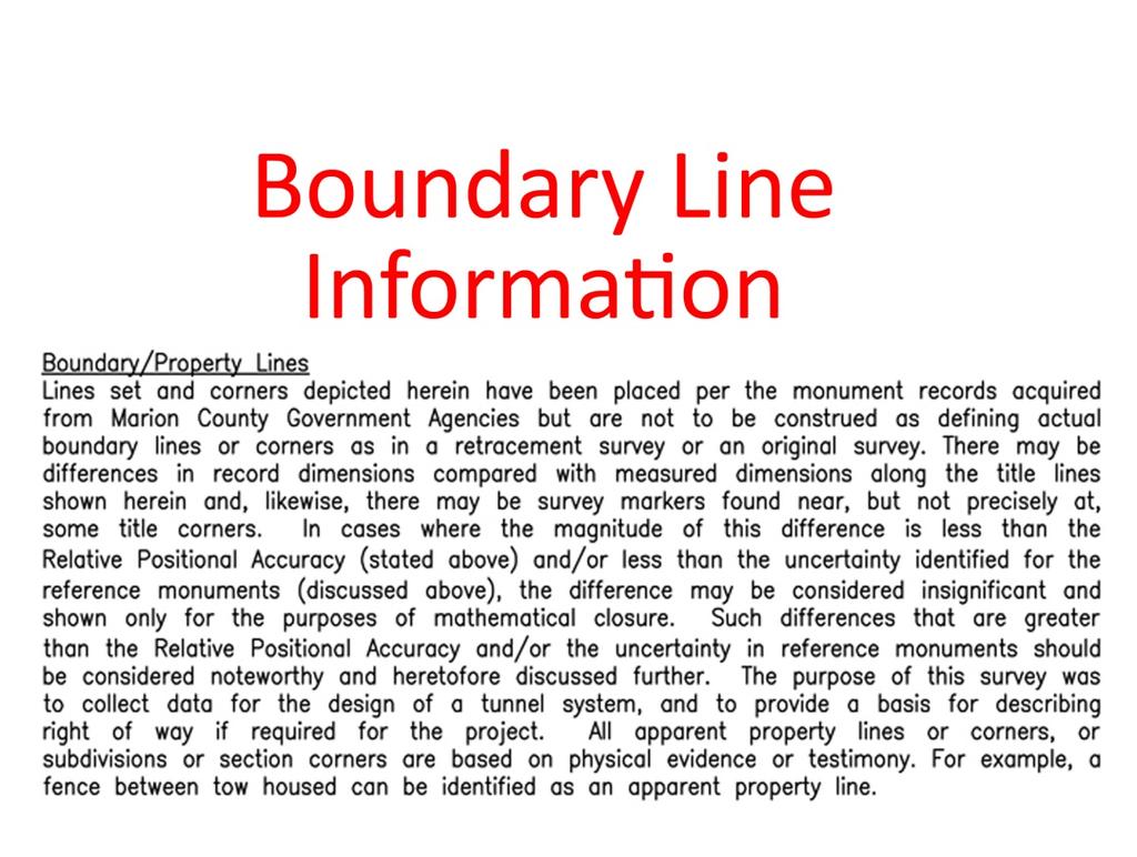
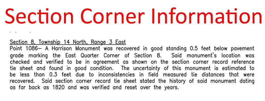
12 What Does a LCRS Plat Look Like? Known Easements Section Corner Information Control Line and Alignment Point Set Property Ownership Information Apparent Right-of-Way General Notes Control Line Reference Ties For Control Points and Section Corners Control Table with Coordinates in State Plane Values


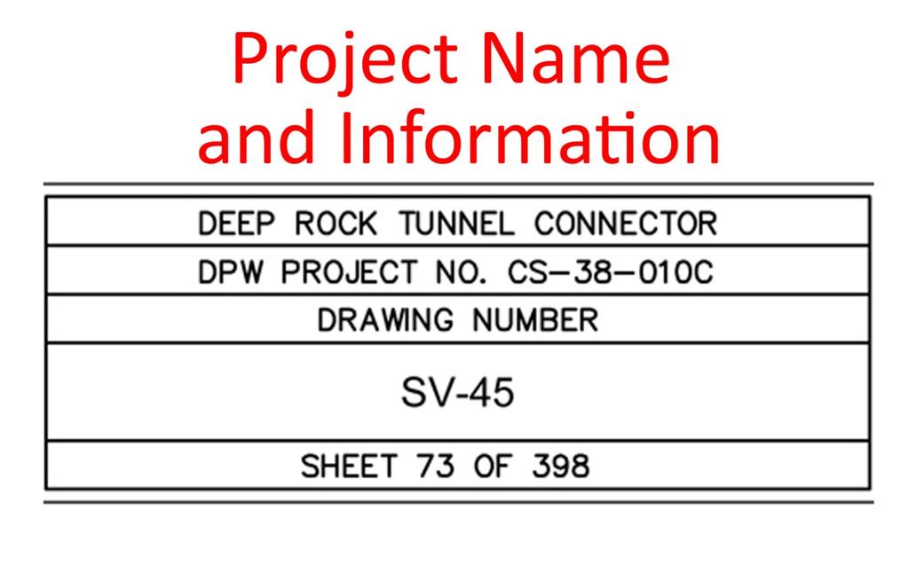
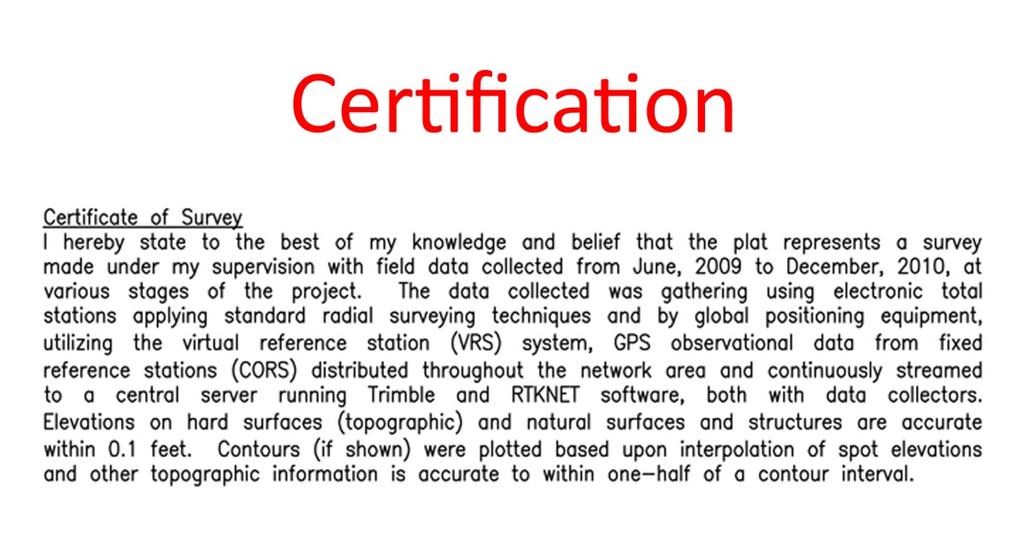
13 What Does a LCRS Surveyors Report Look Like? CITY OF INDIANAPOLISCITY OF INDIANAPOLIS DEPARTMENT OF PUBLIC WORKS SURVEYOR'S REPORT SV-45 DEPARTMENT OF PUBLIC WORKS SURVEYOR'S REPORT SV-45
14 What are the Next Steps? Construction Plans Additional Right of Way Required Parcel Plat and Legal Description Appraisal / Buying Process Construction Completed Project

15 Construction Plans Typical Plan and Profile Sheet (Provided by Engineer)


16 Parcel Plat and Legal Description Instrument Number of the recorded LCRS The location of the parcel. Acreage of the proposed Instrument number of the Acquisition. affected parcel Instrument no. of of the the affected parcel Location of the Acreage Proposed Acquisition Parcel Parcel taking Alignment Points referenced in the LCRS Alignment from the LCRS Alignment from the LCRS Parcel taking Location of the Parcel Instrument number of the affected parcel Alignment Points referenced in the LCRS
17 Summary and Questions What is a Route Survey? When is a Route Survey Mandated? What are the Advantages of a Non-Mandated Route Survey? What are the Minimum Standards of a Route Survey? What is Included in a Route Survey? What Types of Projects May Require a Route Survey? What Does a LCRS Look Like? Chet Parsons, PE chet@pcsengineers.com Grant Niemeyer, PLS grant@pcsengineers.com Rodney Kelly, PLS rkelly@pcsengineers.com
The Right Approach to Right of Way Engineering
 Parsons Cunningham & Shartle Engineers, Inc. Avon, IN & Fishers, IN The Right Approach to Right of Way Engineering www.pcsengineers.com 317-837-9900 The Right Approach to Right of Way Engineering Presented
Land Surveys and Real Property Boundaries
 Land Surveys and Real Property Boundaries There are primarily 5 types of surveys performed on real property in the State of Indiana: Original, Retracement, Route, and Surveyor Location Report (SLR). Lenders
Residential Major Subdivision Review Checklist
 Residential Major Subdivision Review Checklist Plan Submittal Requirements: 2 full sets of stamped plans Electric submittal - all plans contained in a single PDF 3 full sets if commercial kitchen or dining
Residential Minor Subdivision Review Checklist
 Residential Minor Subdivision Review Checklist Plan Submittal Requirements: 2 full sets of stamped plans Electric submittal - all plans contained in a single PDF 3 full sets if commercial kitchen or dining
R/W PREQUALIFICATION ODOT, 3/14/2018
 R/W PREQUALIFICATION ODOT, 3/14/2018 BRETT SHEARER, C.O. REAL ESTATE PROPOSED RIGHT OF WAY DESIGN 172 PROPOSED RIGHT OF WAY DESIGN PROPOSED RIGHT OF WAY DESIGN Section 3200 Types of Title 173 PROPOSED
Plats and subdivisions; mapping requirements. (a) Size Requirements. All land plats presented to the register of deeds for recording in the
 Size Requirements. All land plats presented to the register of deeds for recording in the") 47-30. Plats and subdivisions; mapping requirements. (a) Size Requirements. All land plats presented to the register of deeds for recording in the registry of a county in North Carolina after September
47-30. Plats and subdivisions; mapping requirements. (a) Size Requirements. All land plats presented to the register of deeds for recording in the registry of a county in North Carolina after September
Presented by: Michael G. Geier, PLS Snyder & Associates, Inc.
 Presented by: Michael G. Geier, PLS Snyder & Associates, Inc. Background Society of Land Surveyors of Iowa (SLSI) Iowa County Recorders Association (ICRA) Iowa Land Records (ILR) Started a process three
NOT TO BE SUBMITTED WITH SKETCH DESIGN APPROVAL Subdivision Checklist: Major Subdivision Final Plat
 Must be received with review fee (equal to $200.00, plus $25.00 per lot) no later than 15 days prior to Planning Board meeting, which is normally the first Monday of the month (certain holidays may modify
COUNTY OF ALBEMARLE APPLICATION FOR RURAL SUBDIVISION
 Page 1 APPLICATION FOR RURAL SUBDIVISION The term rural subdivision means a type of subdivision that is located in the rural areas which results in two or more lots for the purpose of transfer of ownership
Cross Reference: Instrument No. A State Parcel No Parcel: TEMPORARY CONSTRUCTION EASEMENT AGREEMENT
 Cross Reference: Instrument No. A199500066899 Project: 92TU000128 State Parcel No. 49-07-18-107-004.000-801 Parcel: 8033304 Date: Version: TEMPORARY CONSTRUCTION EASEMENT AGREEMENT THIS TEMPORARY CONSTRUCTION
EASEMENT BASICS. Definition of Easement Types. Easements are part of our assets. Easement Research. Access, maintenance and operations.
 EASEMENT BASICS Definition of Easement Types. Easements are part of our assets. Easement Research. Access, maintenance and operations. Right-of-Way Regardless of how sophisticated we become, this is still
RULES OF THE GEORGIA STATE BOARD OF REGISTRATION FOR PROFESSIONAL ENGINEERS AND LAND SURVEYORS CHAPTER APPLICATIONS TABLE OF CONTENTS
 RULES OF THE GEORGIA STATE BOARD OF REGISTRATION FOR PROFESSIONAL ENGINEERS AND LAND SURVEYORS CHAPTER 180-7 APPLICATIONS TABLE OF CONTENTS 180-7-.07 Maps and Plats. All maps, plats and similar documents
VIRGINIA DEPARTMENT OF TRANSPORTATION SURVEY SUBCOMMITTEE WHITE PAPER SURVEY IMPLEMENTATION PLAN MAY 15, 2009
 VIRGINIA DEPARTMENT OF TRANSPORTATION SURVEY SUBCOMMITTEE WHITE PAPER SURVEY IMPLEMENTATION PLAN MAY 15, 2009 INTRODUCTION: It is the intention of this office to provide accurate and complete survey information,
PLANNING COMMISSION SUBDIVISION PLAT APPLICATION
 PLANNING COMMISSION SUBDIVISION PLAT APPLICATION Economic Development Department 3468 North Fulton Avenue Hapeville, Georgia 30354 Phone - 404.669.8269 Fax 404.669.3302 Rev. 09/23/16 1 The following information
MAJOR RESIDENTIAL AND NONRESIDENTIAL SUBDIVISIONS
 Lawrence-Douglas County MAJOR RESIDENTIAL AND NONRESIDENTIAL SUBDIVISIONS Preliminary Plats The applicant shall schedule a Pre-Application meeting with Planning Staff at least seven (7) working days prior
CITY OF STRONGSVILLE PLANNING COMMISSION APPLICATION. PARCEL SPLIT and/or ADJOINMENTS
 CITY OF STRONGSVILLE PLANNING COMMISSION APPLICATION PARCEL SPLIT and/or ADJOINMENTS Requires a Planning Commission application. After meeting with City Planner, George Smerigan (if necessary) regarding
TOWN OF ROXBURY PLANNING BOARD
 UPDATED: APRIL 2011 TOWN OF ROXBURY PLANNING BOARD Applicant s Guide for Subdivision Review The Town Planning Board administers the subdivision review process. This guide has been prepared in order to
Preliminary Subdivision Application (Major) (Four (4) lots or more)
 (Four (4) lots or more)") Gunnison City Offices www.gunnisoncity.org 38 West Center Gunnison, Utah 84634 (435) 528 7969 Date of Application: Preliminary Subdivision Application (Major) (Four (4) lots or more) APPLICANT INFORMATION
Gunnison City Offices www.gunnisoncity.org 38 West Center Gunnison, Utah 84634 (435) 528 7969 Date of Application: Preliminary Subdivision Application (Major) (Four (4) lots or more) APPLICANT INFORMATION
Standards for All Instruments of Conveyance
 Standards for All Instruments of Conveyance Perry County, Ohio Effective Date: May 1, 1997 Effective Date of Revision: April 1, 2011 Page 2 of 12 Minimum Standards for all Instruments of Conveyance Perry
APPLICATION PROCEDURES FOR A PLAT AMENDMENT OR REVISION
 APPLICATION PROCEDURES FOR A PLAT AMENDMENT OR REVISION DEFINITION: Any revision or amendment to an approved recorded or unrecorded final plat. A revision (not recorded) does not require a public hearing
Minimum Requirements. In Carroll County, Ohio
 Minimum Requirements For Instruments of Conveyance In Carroll County, Ohio Revision History: Original Effective Date: June 1, 2000 Revision Effective Date: October 2, 2017 Foreword Section 319.203 of the
STONE COUNTY PRELIMINARY PLAT CHECKLIST. Note: Applications need to be in the office by 2 p.m. on the cutoff day.
 STONE COUNTY PRELIMINARY PLAT CHECKLIST Note: Applications need to be in the office by 2 p.m. on the cutoff day. JOY WILSON, DIRECTOR Return form to: Planning & Zoning Administrator PO Box 301, Galena,
Boundary Line Adjustment Application
 Boundary Line Adjustment Application A COMPLETE APPLICATION is required at the time of submittal. REQUIRED SUBMITTALS: 1. Application form 2. Application Fee - $500.00. 3. Current title report 4. Three
Application for Preliminary Plat Checklist
 Application for Preliminary Plat Checklist Note: No portion of an existing parcel may be sold or transferred to another party without first legally subdividing the property according to the City of Richmond
Plat Checklist PLAT TYPES AND DESCRIPTIONS
 Master Plan / Revision to Master Plan (For Platting Purposes Only) Preliminary/Final Plat Preliminary Plat Final Plat Minor Plat Replat Amended Plat Plat Checklist So that we may efficiently review your
SUBDIVISION APPLICATION
 SUBDIVISION APPLICATION Preliminary Plat Minor Plat Final Plat Amended Plat Applicant Name: Owner (if different from applicant) Name: Company: Company: Address: Address: City, State, Zip City, State, Zip
Lake County Planning, Building and Development Department
 SUBMISSION CHECKLIST FOR SUBDIVISION FINAL PLAT Lake County Planning, Building and Development Department 500 W. Winchester Rd. Unit 101 Libertyville, Illinois 60048-1331 Telephone (847) 377-2600 E-mail:
Sketch Plan 2018 Bargersville Plan Commission Application Kit
 Sketch Plan 2018 Bargersville Plan Commission Application Kit For Commercial, Industrial, and Residential Developments At least 31 days prior to the intended filing of the Primary Plat or Development Plan
R/W PREQUALIFICATION ODOT, 3/14/2018 PROPERTY MAP SHEET
 R/W PREQUALIFICATION ODOT, 3/14/2018 3A Title Block 3B Sheet Heading 3C Station Limit Flags 3D Revision Block 3E Ownership Name and Number 3F Centerline Stationing 3G Proposed R/W and Pavement 3H Structures
Auditor's Office Tuscarawas County
 Auditor's Office Tuscarawas County MATT JUDY, Auditor Telephone 125 E. High Avenue (330) 365-3220 New Philadelphia, Ohio 44663 Fax: (330) 365-3397 TO: FROM: Title Companies, Surveyors, Attorneys & Financial
Secret and Forgotten Elements of Rule 12
 Secret and Forgotten Elements of Rule 12 Indiana Society of Professional Land Surveyors Indianapolis, Indiana January 18, 2017 Presented by Gary R. Kent, PS The Schneider Corporation Indianapolis, Indiana
CITY OF SARALAND PRELIMINARY SUBDIVISION PLAT REVIEW
 PRELIMINARY SUBDIVISION PLAT REVIEW Application Number: Date Plat Submitted: Name of Subdivision: Name of Owner: Owner Address: (Street or P.O. Box) Telephone #: (City) (State) (Zip) E-mail: Name of Authorized
STANDARDS GOVERNING CONVEYANCES OF REAL PROPERTY IN SENECA COUNTY OHIO
 STANDARDS GOVERNING CONVEYANCES OF REAL PROPERTY IN SENECA COUNTY OHIO EFFECTIVE July 8, 1996 Seneca County Auditor FIRST HEARING June 14, 1996 SECOND HEARING June 26, 1996 Seneca County Engineer TABLE
SUBDIVISION APPLICATION
 SUBDIVISION APPLICATION City of Horn Lake Planning Department 3101 Goodman Road, W Horn Lake, MS 38637 662-342-3559 Fax: 662-342-3485 Applications due the 1st working day of the month. Submit application
Kyle Eichhorn, PE, PS Project Manager
 Kyle Eichhorn, PE, PS Project Manager PROFESSIONAL EXPERIENCE Kyle is a Project Manager for the Schneider Corporation s office located in Indianapolis, Indiana. Kyle has 9 years of diversified engineering
Easements, Establishments, Abandonments and Vacations
 Easements, Establishments, Abandonments and Vacations A highway easement conveys, in perpetuity, the right to construct and maintain a highway facility on the land of the fee holder. (Property owner) The
GENESEE VALLEY LAND SURVEYORS ASSOCIATION MINIMUM STANDARDS FOR A MAP OF A SURVEY. Effective Date: February 15, 2017
 GENESEE VALLEY LAND SURVEYORS ASSOCIATION MINIMUM STANDARDS FOR A MAP OF A SURVEY Effective Date: February 15, 2017 1. The Land Surveyor shall perform due diligence in their research, maintain proper documentation
FINAL SUBDIVISION AND LAND DEVELOPMENT PLAN CHECKLIST. Plan Name. Applicant's Name:
 TOWNSHIP OF UPPER ST. CLAIR FINAL SUBDIVISION AND LAND DEVELOPMENT PLAN CHECKLIST Date Filed Plan Name PLC Applicant's Name: Phone Filing Date for Final Application Final Plat 114.22. FINAL APPLICATION
WASTEWATER BACKFLOW RELEASE PROCEDURES
 WASTEWATER BACKFLOW RELEASE PROCEDURES PROCEDURE FOR OBTAINING A WASTEWATER RELEASE FOR PRIVATE DEVELOPMENT PROJECTS: PLEASE NOTE THAT THE WASTEWATER BACKFLOW RELEASE DOCUMENT MUST FOLLOW THE CITY S PROCEDURES.
Change In The Name Of Owner (s) Of Land.
 Of Land.") Clermont County TRANSFER AND CONVEYANCE STANDARDS OF THE CLERMONT COUNTY AUDITOR AND THE CLERMONT COUNTY ENGINEER AS ADOPTED UNDER OHIO REVISED CODE SECTION 319.203, AS A RESULT OF TWO PUBLIC HEARINGS
Clermont County TRANSFER AND CONVEYANCE STANDARDS OF THE CLERMONT COUNTY AUDITOR AND THE CLERMONT COUNTY ENGINEER AS ADOPTED UNDER OHIO REVISED CODE SECTION 319.203, AS A RESULT OF TWO PUBLIC HEARINGS
Department of Development Services Engineering; Survey Plat Review Group SPRG
 Department of Development Services Engineering; Survey Plat Review Group SPRG CITY OF DALLAS LEGAL DESCRIPTION PREPARATION GUIDELINE AND CHECKLIST The following guideline and checklist are provided to
Township of Collier 2418 Hilltop Road Presto, PA 15142
 Township of Collier 2418 Hilltop Road Presto, PA 15142 Fees: Major: 2 checks $600 + $50 per lot & $1700 Escrow) APPLICATION FOR SUBDIVISION major FINAL only Plans must be folded Rolled plans will not be
BOUNDARY ADJUSTMENT APPLICATION
 BOUNDARY ADJUSTMENT APPLICATION COMMUNITY DEVELOPMENT DEPARTMENT / PLANNING DIVISION 8130 Allison Avenue, La Mesa, CA 91942 Phone: 619.667.1177 Fax: 619.667.1380 NOTE: The City of La Mesa emphasizes that
SUBMITTAL REQUIREMENTS: The number indicates the number of copies for submittal (if applicable).
.") Office Use Only Preliminary Long Plat Long Subdivision Applicant Checklist PLANNING, COMMUNITY, & ECONOMIC DEVELOPMENT DEPARTMENT FINAL LONG PLAT LONG SUBDIVISION CHECKLIST Mailing Address: P.O. Box 547,
Office Use Only Preliminary Long Plat Long Subdivision Applicant Checklist PLANNING, COMMUNITY, & ECONOMIC DEVELOPMENT DEPARTMENT FINAL LONG PLAT LONG SUBDIVISION CHECKLIST Mailing Address: P.O. Box 547,
FINAL PLAN CHECKLIST
 FINAL PLAN CHECKLIST Subdivision Name: Subdivision Number: Project Number: REVIEW CRITERIA Plans: A final plan shall be on a 24 x 36 sheet at a scale that is no smaller than 1 = 40 and shall contain all
MINNESOTA ASSOCIATION OF COUNTYSURVEYORS MANUAL OF MINIMUM GUIDELINES FOR THE PREPARATION OF COUNTY HIGHWAY RIGHT-OF-WAY PLATS
 MINNESOTA ASSOCIATION OF COUNTYSURVEYORS MANUAL OF MINIMUM GUIDELINES FOR THE PREPARATION OF COUNTY HIGHWAY RIGHT-OF-WAY PLATS MARCH,1994 j RECOMMENDED BY: MINNESOTA ASSOCIATION OF COUNTY SURVEYORS MINNESOTA
Preliminary Subdivision Application (Minor) (Three (3) lots or less)
 (Three (3) lots or less)") Gunnison City Offices www.gunnisoncity.org 38 West Center Gunnison, Utah 84634 (435) 528 7969 Date of Application: Preliminary Subdivision Application (Minor) (Three (3) lots or less) APPLICANT INFORMATION
Gunnison City Offices www.gunnisoncity.org 38 West Center Gunnison, Utah 84634 (435) 528 7969 Date of Application: Preliminary Subdivision Application (Minor) (Three (3) lots or less) APPLICANT INFORMATION
OHIO ADMINISTRATIVE CODE CHAPTER Minimum Standards for Boundary Surveys in the State of Ohio
 OHIO ADMINISTRATIVE CODE CHAPTER 4733-37 Minimum Standards for Boundary Surveys in the State of Ohio Note: Chapter 4733-37 of the Administrative Code was filed pursuant to Chapter 119 of the Revised Code.
DIVISION 2 - CONSTRUCTION PLAN AND MISCELLANEOUS REQUIREMENTS
 DIVISION 2 - CONSTRUCTION PLAN AND MISCELLANEOUS REQUIREMENTS 2.1 Required Plan Sheets 2.2 Drawing Requirements 2.3 Graphic Standards 2.4 Easements 2.5 Utility Locations 2.6 Private Facility Locations
APPLICATION FOR FINAL PLAT APPROVAL
 APPLICATION FOR FINAL PLAT APPROVAL Section 1. General. The undersigned Applicant (Applicant is synonymous with owner) makes this Application for Final Plat Approval in accordance with Chapter 21, Port
250 CMR: BOARD OF REGISTRATION OF PROFESSIONAL ENGINEERS AND LAND SURVEYORS DRAFT FOR DISCUSSION PURPOSES ONLY
 250 CMR 6.00: LAND SURVEYING PROCEDURES AND STANDARDS Section 6.01: Elements Common to All Survey Works 6.02: Survey Works of Lines Affecting Property Rights All land surveying work is considered work
DALLAS WATER UTILITIES WATER/WASTEWATER COVENANT
 DALLAS WATER UTILITIES WATER/WASTEWATER COVENANT Procedure for obtaining a water and wastewater covenant, water covenant, or wastewater covenant; Required for initial submittal: 1. One letter from the
Gates County Planning and Zoning
 Gates County Planning and Zoning PO Box 411, 200 Court Street, Gatesville, NC 27938 phone: 252-357-2411 fax: 252-357-0073 Application for Technical Review Committee For Staff Use Only: Date: Application
Standards of Practice for Surveying in the State of Alabama
 Standards of Practice for Surveying in the State of Alabama Effective January 1, 2017 RULE NO. 1.01 PURPOSE The purpose of these rules is to establish standards for the practice of surveying in the State
SUBDIVISION APPLICATION CHECKLIST SKETCH PLAN PRELIMINARY PLAT FINAL PLAT
 RECEIVED STAMP SUBDIVISION APPLICATION CHECKLIST SKETCH PLAN PRELIMINARY PLAT FINAL PLAT A checklist of background information and submission requirements for processing of a sketch plan, preliminary plat
MnDOT Contract No Exhibit B. Scope of Work. Scope of Work
 MnDOT Contract No. 1032993 Contract General Description The purpose of this contract is to provide the State with the survey accurate re-establishment of designated Public Land Survey section boundaries
STANDARDS GOVERNING CONVEYANCES OF REAL PROPERTY IN DARKE COUNTY, OHIO
 STANDARDS GOVERNING CONVEYANCES OF REAL PROPERTY IN DARKE COUNTY, OHIO As directed by Section 319.203 of the Ohio Revised Code which states The County Auditor and the County Engineer shall adopt standards
PETITION FOR VOLUNTARY ANNEXATION Town of Apex, North Carolina
 Town of Apex, North Carolina ANNEXATION PETITION SUBMISSION: Applications are due by 12:00 pm on the first business day of each month. See the Annexation Petition Schedule on the website for details. ANNEXATION
MINOR SUBDIVISION PLAT
 CHECKLIST HANCOCK COUNTY AREA PLAN COMMISSION A subdivider shall submit to the Plan Commission office an application and an accompanying plat for a minor subdivision. The plat shall be based on a boundary
SECTION 6 - APPROVAL OF PLATS. Whenever any subdivision of land is proposed, and before any permit for the
 SECTION 6 - APPROVAL OF PLATS 6-1 APPROVAL REQUIRED BEFORE SALE Whenever any subdivision of land is proposed, and before any permit for the erection of a structure shall be granted, the subdivider or his
FINAL PLAT APPLICATION
 FINAL PLAT APPLICATION (Page 1 of 3) LEGAL OWNER(s): NAME: STREET ADDRESS OWNER(s): CITY, STATE, ZIP CODE: PHONE NUMBER: BILLING ADDRESS: NAME OF ENGINEER/SURVEYOR: Engineer/Surveyor Address, Phone: PROPERTY
GENERAL ASSEMBLY OF NORTH CAROLINA SESSION 2017 H 1 HOUSE BILL 454* Short Title: Surveying and Plat Recording Changes. (Public)
") GENERAL ASSEMBLY OF NORTH CAROLINA SESSION H 1 HOUSE BILL * Short Title: Surveying and Plat Recording Changes. (Public) Sponsors: Referred to: Representative Arp. For a complete list of sponsors, refer
GENERAL ASSEMBLY OF NORTH CAROLINA SESSION H 1 HOUSE BILL * Short Title: Surveying and Plat Recording Changes. (Public) Sponsors: Referred to: Representative Arp. For a complete list of sponsors, refer
RESCINDING A BINDING LOT AGREEMENT
 SECTION 29.0 RESCINDING A BINDING LOT AGREEMENT Section 29.01 Purpose This section describes the process in order to rescind a binding lot agreement. The owner(s) of the lots bound together through the
SUBMITTAL REQUIREMENTS: The number indicates the number of copies for submittal (if applicable).
.") Office Use Only Preliminary Long Plat Long Subdivision Applicant Checklist PLANNING, COMMUNITY, & ECONOMIC DEVELOPMENT DEPARTMENT PRELIMINARY LONG PLAT LONG SUBDIVISION CHECKLIST Mailing Address: P.O.
Office Use Only Preliminary Long Plat Long Subdivision Applicant Checklist PLANNING, COMMUNITY, & ECONOMIC DEVELOPMENT DEPARTMENT PRELIMINARY LONG PLAT LONG SUBDIVISION CHECKLIST Mailing Address: P.O.
CITY OF NOVI LAND DIVISION INSTRUCTIONS
 CITY OF NOVI LAND DIVISION INSTRUCTIONS All applications for land division in the City of Novi must be in compliance with Chapter 32 of the City of Novi Code of Ordinances and with the Land Division Act,
WESTON COUNTY FINAL PLAT APPLICATION
 WESTON COUNTY FINAL PLAT APPLICATION Property Owner: Mailing Address of owner: Telephone Number(s) of owner: Property Owner: Mailing Address of owner: Telephone Number(s) of owner: (If subdivider/applicant
Map Filing Law. 46: Effective date This act shall take effect January first, one thousand nine hundred and fiftyfour.
 46:23-9.8. Effective date This act shall take effect January first, one thousand nine hundred and fiftyfour. L.1953, c. 358, p. 1941, s. 8. 46:23-9.9. Short title This act shall be known and may be cited
CHAPTER FINAL AND PARCEL MAPS
 CHAPTER 19.48 FINAL AND PARCEL MAPS Section Page 19.48.010 General... IV-25 19.48.020 Phasing... IV-25 19.48.030 Survey Required... IV-26 19.49.040 Form... IV-26 19.48.050 Contents... IV-27 19.48.060 Preliminary
APPLICATION FOR FINAL PLAT APPROVAL (Major Subdivision)
") APPLICATION FOR FINAL PLAT APPROVAL (Major Subdivision) CITY OF HOSCHTON, GA PLANNING AND DEVELOPMENT 79 City Square Hoschton, GA 30548 706-654-3034 Applicant Information: Name: Address: City, State, Zip:
APPLICATION FOR FINAL PLAT APPROVAL (Major Subdivision) CITY OF HOSCHTON, GA PLANNING AND DEVELOPMENT 79 City Square Hoschton, GA 30548 706-654-3034 Applicant Information: Name: Address: City, State, Zip:
COUNTY OF ALBEMARLE APPLICATION FOR FAMILY DIVISION. Family Division = $742 (Provide 5 copies of plat)
") Page 1 APPLICATION FOR FAMILY DIVISION Family Division = $742 (Provide 5 copies of plat) Tier 2 Groundwater Review = $355 (Required for all plats showing lots less than 21 acres) Tier 3 Groundwater Review
Page 1 APPLICATION FOR FAMILY DIVISION Family Division = $742 (Provide 5 copies of plat) Tier 2 Groundwater Review = $355 (Required for all plats showing lots less than 21 acres) Tier 3 Groundwater Review
Easements, Establishments, Abandonments and Vacations
 Easements, Establishments, Abandonments and Vacations Highway Easements: Where there is a right to construct and maintain a highway facility SH - Standard Highway easement LA - Limited Access Easement
RE: File No. LD 1516 Certified Survey Map Tradewinds Parkway (B-R Enterprises of Madison, LLC)
") Department of Planning & Community & Economic Development Planning Division Katherine Cornwell, Director Madison Municipal Building, Suite LL-100 215 Martin Luther King, Jr. Boulevard P.O. Box 2985 Madison,
Department of Planning & Community & Economic Development Planning Division Katherine Cornwell, Director Madison Municipal Building, Suite LL-100 215 Martin Luther King, Jr. Boulevard P.O. Box 2985 Madison,
REQUIREMENTS FOR ALL INSTRUMENTS OF CONVEYANCE IN HARDIN COUNTY, OHIO
 REQUIREMENTS FOR ALL INSTRUMENTS OF CONVEYANCE IN HARDIN COUNTY, OHIO Effective Date: Michael L. Smith, P.E., P.S. Hardin County Engineer Michael T. Bacon Hardin County Auditor 1 I. GENERAL In compliance
Final Plat Approval of a Minor Subdivision Application Packet
 Final Plat Approval of a Minor Subdivision Application Packet 1. Application Packet. Be sure to complete and submit all the required materials that are a part of this Application Packet. Failure to do
The Filing Fee for a Minor Plat is $ PLUS $20.00 per lot created
 DEPARTMENT OF COMMUNITY DEVELOPMENT MINOR PLAT PROCEDURE The Filing Fee for a Minor Plat is $250.00 PLUS $20.00 per lot created Description: The purpose of a Minor Plat is to allow property to be platted
Minor Subdivision Application
 FOR PLANNING USE ONLY Application # SD Application Fee $1,000.00 Receipt No. Filing Date Completeness Date Minor Subdivision Application A. PROJECT INFORMATION 1. Project Name: 2. Address of Subject Property:
CERTIFICATION OF THE APPROVAL OF WATER AND SEWERAGE SYSTEMS
 ARTICLE 9 FORMS AND CHECK LISTS 9.100 On preliminary layout & final subdivision plat CERTIFICATION OF THE APPROVAL OF WATER AND SEWERAGE SYSTEMS I hereby certify that the (...type: private or pubic...)
SUBDIVISION AND LAND DEVELOPMENT. 185 Attachment 20
 185 Attachment 20 APPENDIX S Plat No. Date of Submission Twp. Fee $ Dauphin Co. Fee $ TOWNSHIP OF DERRY SUBDIVISION OR LAND DEVELOPMENT PLAN SUBMISSION APPLICATION This block for Twp. use only 1. Title
LAND DEVELOPMENT CHECKLIST GREEN TREE BOROUGH Green Tree Planning Commission 10 West Manilla Avenue Pittsburgh, PA
 TO BE COMPLETED BY BOROUGH: LAND DEVELOPMENT CHECKLIST GREEN TREE BOROUGH Green Tree Planning Commission 10 West Manilla Avenue Pittsburgh, PA 15220 412-921-1110 SP - - DATE STAMP RECEIVED NOTE TO ALL
ELMORE COUNTY LAND USE & BUILDING DEPARTMENT 520 E 2 nd South Mountain Home, ID (208) Preliminary Plat Application
 Preliminary Plat Application") ELMORE COUNTY LAND USE & BUILDING DEPARTMENT 520 E 2 nd South Mountain Home, ID 83647 (208) 587-2142 www.elmorecounty.org Preliminary Plat Application We are unable to accept facsimile copies. (Subdivisions
ELMORE COUNTY LAND USE & BUILDING DEPARTMENT 520 E 2 nd South Mountain Home, ID 83647 (208) 587-2142 www.elmorecounty.org Preliminary Plat Application We are unable to accept facsimile copies. (Subdivisions
TOWNSHIP OF EGG HARBOR ZONING BOARD ADJUSTMENT CHECK LIST
 TOWNSHIP OF EGG HARBOR ZONING BOARD ADJUSTMENT CHECK LIST Schedule A - General Requirements 1. Where the application involves only a variance one (1) original and nineteen (19) copies of the appropriate
DAWSON COUNTY MINOR PLAT REVIEW CHECKLIST $50.00 FEE PER PLAT REVIEW, $5.00 FEE FOR SCAN & CD FOR RECORDING
 DAWSON COUNTY MINOR PLAT REVIEW CHECKLIST $50.00 FEE PER PLAT REVIEW, $5.00 FEE FOR SCAN & CD FOR RECORDING NAME ON PLAT: CONTACT/PHONE #: NAMED STREET/ADDRESS: LAND LOT: DISTRICT: SECTION: ZONING: SETBACKS:
Conveyance Standards. Boundary Survey Requirements. Adams County, Ohio
 Conveyance Standards And Boundary Survey Requirements Adams County, Ohio OFFICE OF THE ADAMS COUNTY AUDITOR DAVID GIFFORD 110 WEST MAIN STREET WEST UNION, OH 45693 OFFICE OF THE ADAMS COUNTY ENGINEER DAVID
COMMUNITY DEVELOPMENT DEPARTMENT
 COMMUNITY DEVELOPMENT DEPARTMENT SUBDIVISION APPLICATION - PRELIMINARY FOR CITY USE ONLY Date Received: Date Determined Complete: Fees Paid: PC Meeting: CC Meeting: $250 + $25 per lot; plus all applicable
Instructions for Maps to Accompany Proof of Appropriation and Beneficial Use of Ground Water
 Instructions for Maps to Accompany Proof of Appropriation and Beneficial Use of Ground Water Part II of the Proof of Appropriation (Form U.W. 8) All maps to accompany proof of appropriation and beneficial
GETTING YOUR ROW PROJECT STARTED RIGHT A WAY Best Practices. October 11, 2017 Best Practices October 11, 2017
 GETTING YOUR ROW PROJECT STARTED RIGHT A WAY Best Practices October 11, 2017 ROW Customer Service Right of Way provides courteous, accurate, and timely customer-centered services, creating a positive experience.
SECTION SITE SURVEYS
 PART 1 - GENERAL 1.1 DESCRIPTION SECTION 02 21 00 SPEC WRITER NOTES: 1. Use this section only for NCA projects. 2. Delete between //---// if not applicable to project. Also delete any other item or paragraph
ARTICLE 3 DEFINITIONS
 Sections: 3-1 Rules of Construction 3-2 Definitions ARTICLE 3 DEFINITIONS SECTION 3-1 RULES OF CONSTRUCTION 3-101. a. The language set forth in these regulations shall be interpreted in accordance with
Application for a Deminimus Development
 Okeechobee County Community Development Department 1700 NW 9 th Avenue, Suite A Okeechobee, FL 34972 Phone (863) 763-5548 Fax (863) 763-5276 planning@co.okeechobee.fl.us A deminimus development is the
Requirements for All Instruments of Conveyance in Logan County, Ohio
 Requirements for All Instruments of Conveyance in Logan County, Ohio Effective Date: April 11, 1997 It is the intent of these requirements to provide a standard method of checking legal descriptions for
A.3. ARTICLE 7 PLAN REQUIREMENTS FOR MINOR SUBDIVISION AND/OR LAND DEVELOPMENT
 700. 701.A.3. ARTICLE 7 PLAN REQUIREMENTS FOR MINOR SUBDIVISION AND/OR LAND DEVELOPMENT SECTION 700 PURPOSE The purpose of this Article is to set forth a streamlined set of Plan Requirements for minor
IC Chapter 12. County Surveyor
 IC 36-2-12 Chapter 12. County Surveyor IC 36-2-12-1 Application of chapter Sec. 1. This chapter applies to all counties. IC 36-2-12-2 Residence; term of office Sec. 2. (a) The county surveyor must reside
LAND PARCEL IDENTIFICATION FOR AUTOMATED LAND INFORMATION SYSTEMS
 LAND PARCEL IDENTIFICATION FOR AUTOMATED LAND INFORMATION SYSTEMS D a r r e l l R. D e a n, J r., Teaching Assistant Surveying and Mapping Purdue University R E C O G N IT IO N O F N EED F O R M O R E
City of Prior Lake APPLICATION FOR REGISTERED LAND SURVEY
 Case File No. Property Identification No. City of Prior Lake APPLICATION FOR REGISTERED LAND SURVEY Requested Action Brief description of proposed project (Please describe the proposed amendment, project,
A Final Plat will be reviewed concurrently with any other development review application(s) that is required.
 that is required.") RELATED FACTS TO KNOW: Adams County Recording Requirements, Annexation, Common Wall Subdivision, Development Plan (PUD Development Permit), Fees, Helpful Contact Information, Lot Line Adjustment, Neighborhood
RELATED FACTS TO KNOW: Adams County Recording Requirements, Annexation, Common Wall Subdivision, Development Plan (PUD Development Permit), Fees, Helpful Contact Information, Lot Line Adjustment, Neighborhood
Administrative Application Duplex Subdivisions
 Department of Community Development 75 South Frontage Road Vail, CO 81657 Tel: 970-479-2128 www.vailgov.com Development Review Coordinator Administrative Application Duplex Subdivisions General Information:
BOROUGH OF HELLERTOWN 685 Main St., Hellertown PA Phone: Fax:
 SUBDIVISION / LAND DEVELOPMENT REVIEW CHECKLIST Subdivision / Land Development Preliminary Plan Preliminary Plan Checklist A scaled plan not less that 1 = 100 feet (422.01) Proposed subdivision name or
CITY OF RAPID CITY RAPID CITY, SOUTH DAKOTA 57701
 CITY OF RAPID CITY RAPID CITY, SOUTH DAKOTA 57701 Public Works Department Engineering Services Division 300 Sixth Street Telephone: (605) 394-4154 FAX: (605) 355-3083 Web: www.rcgov.org TO: FROM: Public
Subdivisions. CITY OF OAK HARBOR Development Services Department
 CITY OF OAK HARBOR Development Services Department Subdivisions Finall Platt Applicatti ion Review Prrocess VII What is a Subdivision? A subdivision is the division of land into ten or more lots, tracts,
Certified Survey Review Instructions
 DEARBORN COUNTY PLAN COMMISSION County Administration Building, 165 Mary St., Lawrenceburg, IN 47025 Phone (812) 537-8821 Fax (812) 532-2029 Website: www.dearborncounty.org/planning Certified Survey Review