Tax Map & Property Information Location Map Assessment Information Municipal Information Zoning Information...
|
|
|
- Silvester Hicks
- 6 years ago
- Views:
Transcription
1 Table of Contents Parcel # /- Acres Office/Warehouse Buildings Gordon Drive Rockland, Maine Keenan Auction Company Tax Map & Property Information... 1 Location Map... 2 Assessment Information... 3 Municipal Information... 6 Zoning Information... 7 Zoning Map... 9 Deed Description Property Disclosure Form Improvement Description The following documents can be accessed from our website keenanauction.com: Environmental Site Assessment Note: Please use page number in lower right hand corner of page

2 PARCEL # /- Acres Office/Warehouse Buildings Gordon Drive Rockland, Maine Tax Map 61, Lot B8 Parcel #5 Office/Warehouse Buildings, Gordon Drive, Rockland, Maine 5.99+/- Acres w/ 580+/- ft on Gordon Dr. and 450+/- ft on Moran Dr., located in the Rockland Industrial Park 1 mile from US Rt. 1, (2) Metal-framed industrial warehouse buildings totaling 36,936+/-SF and a 576+/-SF wood-frame garage. Building 1 23,296+/-SF, metal and wood frame, built 1986+/-, 2,241+/-SF professional office section, 21,055+/-SF production/warehouse section, 2-20 OH doors, 1-9x10 OH door, and 2-large double doors for drive-in boat access/storage, HVAC oil & elec office heat, FHA & suspended ceiling units in production area, radiant floor heat in one section of warehouse, 3Phase/200 amp service, central dry sprinkler system, air exchange system. Building 2 13,640+/-SF, metal frame, built 1981+/-, 500+/-SF office section, 1,500 mezzanine, 11,640+/-SF production/warehouse section, 3-16 to 20 high OH doors, attached woodframe garage building w/3-9x10 OH doors, Oil fired suspended ceiling units in production area, elec in office, 3Phase/225 amp service, central dry sprinkler system. Industrial I District Zone. Tax Map 61, Lot B8. 1

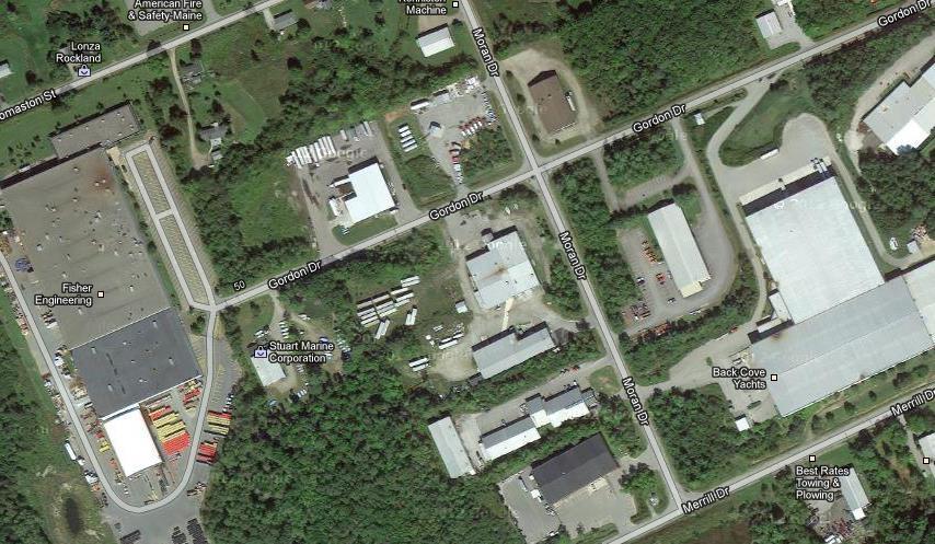
3 Location Map 2 4

4 Assessment Information Powered by Vision Appraisal Technology Gordon Drive, Rockland, Maine Map-Lot-Unit : 061/ B/ / 000/ Location: 28 GORDON DRIVE Owner Name: FERRAIOLO CONSTRUCTION, INC. Account Number: 61B8 Parcel Value Item Appraised Value Assessed Value Buildings 628, ,500 Xtra Bldg Features 9,600 9,600 Outbuildings 5,700 5,700 Land 117, ,500 Total: 761, ,300 Owner of Record FERRAIOLO CONSTRUCTION, INC. 28 GORDON DRIVE ROCKLAND, ME Ownership History Owner Name Book/Page Sale Date Sale Price FERRAIOLO CONSTRUCTION, INC. 3567/ 044 1/26/ ,000 NEC REALTY LLC 2120/ 249 5/15/ ,000 HOCH, WESLEY/MATOON/ROBERT & WHITE, ERIC 1189/ 180 6/30/ HOCH, RUTH/WESLEY/MATOON& WHITE, ERIC 1020/ 311 5/30/ HOCH,RUTH/WESLEY/MATTOON, ROBERT&WHITE,E 996/ /20/ Land Use Land Use Code Land Use Description 4022 Industrial Bldg Land Line Valuation Size Appraised Value Assessed Value 6.14 AC 117, ,500 3

5 Construction Detail Building # 1 STYLE Pre-Eng Mfg MODEL Industrial Stories: 1 Occupancy 1 Exterior Wall 1 Pre-finsh Metl Roof Structure Gable/Hip Roof Cover Metal/Tin Interior Wall 1 Minim/Masonry Interior Floor 1 Concr-Finished Heating Fuel Oil Heating Type Hot Water AC Type None Bldg Use Industrial Bldg Heat/AC NONE Frame Type STEEL Baths/Plumbing AVERAGE Ceiling/Wall NONE Rooms/Prtns AVERAGE Wall Height 24 Building Valuation Living Area: 23,250 square feet Year Built: 1986 Building Value: 405,100 Extra Features Code Description Units Appraised Value SPR3 SPRINKLERS-DRY S.F Outbuildings Code Description Units Appraised Value FGR1 GARAGE-AVE 576 S.F Building Sketch Subarea Summary Code Description Gross Area Living Area BAS First Floor FUS Upper Story, finished


6 Construction Detail Building # 2 STYLE Pre-Eng Mfg MODEL Industrial Stories: 1 Occupancy 1 Exterior Wall 1 Pre-finsh Metl Roof Structure Gable/Hip Roof Cover Metal/Tin Interior Wall 1 Minim/Masonry Interior Floor 1 Concr-Finished Heating Fuel Oil Heating Type Hot Water AC Type None Bldg Use Industrial Bldg Heat/AC NONE Frame Type STEEL Building Valuation Living Area: 12,500 square feet Year Built: 1981 Building Value: 223,400 Extra Features Code Description Units Appraised Value No Extra Building Features Outbuildings Code Description Units Appraised Value SHD1 SHED FRAME 80 S.F. 300 SHD1 SHED FRAME 96 S.F. 400 SHD1 SHED FRAME 96 S.F. 400 Building Sketch Subarea Summary Code Description Gross Area Living Area BAS First Floor FEP Enclosed Porch 60 0 FGR Garage, Attached
7 Municipal Information Real Estate Auction Parcel # Gordon Drive, Rockland, Maine 2013 Mill Rate $ Per $1, Percent of Valuation at Market 100% Tax Map 61, Lot B TAX VALUE: Land $ 117, Building 643, Total Value $ 761, ANNUAL REAL ESTATE TAXES: $ 14, REAL ESTATE TAXES DUE: As of 6/11/ $ 7, PUBLIC WATER DUE: $ as of 6/11/13 PUBLIC SEWER DUE: $ as of 6/11/13 FIRE/SPRINKLER SERVICE DUE: $ as of 6/11/13 ZONING: Industrial Zone (Zone I ) The above information was obtained from the Rockland City Hall. For further details on municipal information please contact the City Hall at
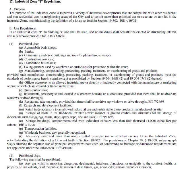
8 Zoning Information 7
9 8

10 Zoning Map 9
11 Auction Parcel # Gordon Drive, Rockland Deed Description Certain lots or parcels of land situated in the Industrial Park in the City of Rockland, County of Knox and State of Maine, bounded and described as follows: FIRST: BEGINNING at a point on the Southerly side of the Industrial Park Road, also known as Gordon Avenue, said point being South 84 53' 24" West Nine Hundred Twenty Six and Sixty Eight Hundredths ( ) feet from the northwesterly corner of Rockland Leathers Company property, now or formerly; thence South 5 6' 34" East Twenty Five (25) feet to an iron rod; thence continuing the same course, South 5 6' 34" East two hundred seventy five (275) feet to an iron rod; thence North 84 53' 24" East two hundred ninety (290) feet to an iron rod, at the line of a fifty foot wide right of way; thence North 5 6' 34" West by said right of way two hundred ninety (290) feet to an iron rod at the point of a curve, to the left with a Ten (10) foot radius and a Ten (10) foot tangent; thence by said curve to the point of tangent at the line of said Industrial Park Road; thence South 84 53' 24" West by said road two hundred eighty (280) feet to the point of beginning. SECOND: BEGINNING at an iron rod in the Westerly side of a Fifty (50) foot wide right of way leading Southerly from the Industrial Park Road called Gordon Drive, said iron rod being at the southeasterly corner of the property now or formerly of Blue Water Partnership and South 5 6' 34" East, a distance of Three Hundred (300) feet from the Southerly line of Gordon Drive; thence South 84 53' 24" West by property now or formerly of Blue Water Partnership, a distance of Two Hundred Ninety (290) feet to an iron rod; thence South 5 6' 34" East, a distance of One Hundred Fifty (150) feet to an iron rod; thence North 84 53' 24" East by land of the City of Rockland, Maine, a distance of Two Hundred Ninety (290) feet to an iron rod at the Westerly side of the said Fifty (50) foot right of way; thence North 5 6' 34" West by said right of way a distance of One Hundred Fifty (150) feet to the place of beginning. THIRD: Beginning at an iron rod placed on the Southerly side of Gordon Drive, said iron rod being South 84 53' 24" West a distance of Two Hundred Ninety (290) feet from the northwesterly corner of land of Ruth Hoch and others as recorded in the Knox County Registry of Deeds, Book 776, Page 77; thence South 5 6' 36" East by land now or formerly of the Inhabitants of the City of Rockland a distance of Three Hundred (300) feet to an iron rod placed; thence North 84 53' 24" East still by a land now or formerly of the Inhabitants of the City of Rockland a distance of Two Hundred Ninety (290) feet to an iron rod at the southwesterly corner of said Hoch and others; thence North 5 6' 36" West by land of said Hoch and others a distance of Two Hundred Seventy Five (275) feet to an iron rod; thence continuing same course North 5 6' 36" West a distance of Twenty Five (25) feet to a Southerly line of Gordon Drive; thence South 84 53' 24" West by said Gordon Drive a distance of Two Hundred Ninety (290) feet to the place of beginning. FOURTH: BEGINNING at a iron rod at the southwesterly corner of land now or formerly of North End Marine and Fiberglass Engineering, Inc. said iron rod being South 5 37' 12" East a distance of Three Hundred (300) feet from an iron rod at the line of Gordon Drive; thence North 84 22' 48" East by land of said Marine Company a distance of Two Hundred Ninety (290) feet to an iron rod; thence South 5 37' 12" East by other land now or formerly of said Marine Company a distance of One Hundred Fifty (150) feet to an iron rod at land of the City of Rockland; thence South 84 22' 48" West by land of the City of Rockland, a distance of Two Hundred Ninety (290) feet to an iron rod placed; thence North 5 37' 12" West still by land of the City of Rockland a distance of One Hundred Fifty (150) feet to the place of beginning. Being the same premises described in a deed from Eric I. White, Wesley A. Hoch, and Robert L. Matoon dated May 9, 1997, recorded in the Knox County Registry of Deeds in Book 2120, Page
12 Subject to an easement to Central Maine Power Company recorded in the Knox County Registry of Deeds in Book 318, Page 407, to the extent it may apply. Subject to an easement from the Inhabitants of the City of Rockland to Central Maine Power Company and New England Telephone and Telegraph Company dated December 19, 1975 and recorded in said Registry in Book 632, Page 196, to the extent it may apply. Subject to Department of Environmental Protection Site Location Order dated June 13, 1979, recorded in said Registry in Book 770, Page 327, and related but unrecorded orders prior and subsequent thereto, which may affect the premises. Subject to restrictions, covenants, and conditions set forth in a deed from the City of Rockland to North End Marine and Fiberglass Engineering, Inc. recorded in said Registry in Book 961, Page 160. Subject to restrictions, covenants, and conditions set forth in a deed from North End Marine and Fiberglass Engineering, Inc. dated December 13, 1984, and recorded in said Registry in Book 996, Page 243, as affected by a release contained in a deed dated May 16, 1985, recorded in said Registry in Book 1020, Page 311. Subject to restrictions, covenants, and conditions set forth in a deed from the City of Rockland dated May 16, 1985, and recorded in said Registry in Book 1020, Page 311. For Grantors source of title reference is made to a deed from NEC Realty, LLC dated January 16, 2006 and recorded in Knox County Registry of Deeds in Book 3567, Page
13 12
14 13
15 DISCLAIMER ATTENTION PROSPECTIVE BIDDER THE IMPROVEMENT DESCRIPTION INFORMATION SET FORTH IN THIS PROPERTY INFORMATION PACKAGE IS BELIEVED TO BE CORRECT AND COMPLETE. HOWEVER, THE KEENAN AUCTION COMPANY AND THE SELLER OF THIS PROPERTY AND ITS AGENTS/REPRESENTATIVES MAKE NO WARRANTIES AS TO THE ACCURACY, TRUTHFULNESS AND COMPLETENESS OF THIS INFORMATION. PRIOR TO THE AUCTION, PROSPECTIVE BIDDERS SHOULD MAKE SUCH INVESTIGATION, AS THEY DEEM APPROPRIATE. 14
16 15
17 16
18 17
19 18
20 19
COM LAND 62,600 MANSFIELD, MA ,700 Additional Owners: Other ID:
 Vision ID: 836 Account # 836 Bldg #: of 3 Sec #: of Card of 4 Print Date:/6/29 22:36 CURRENT OWNER TOPO. UTILITIES STRT./ROAD LOCATION CURRENT ASSESSMENT 4 Rolling 2 Public Water Paved Appraised Value
PROPERTY INFORMATION PACKAGE
 AMG AUCTION MARKETING GROUP PROPERTY INFORMATION PACKAGE Thank you for your interest in the Auction. We have compiled the following Property Information to assist you in your research. Please understand
26 Ermer Road ~ 2nd Floor~ Salem, NH 03097
 26 Ermer Road ~ 2nd Floor~ Salem, NH 03097 Berkshire Hathaway Verani is pleased to announce the availability of an open concept retail/office suite located on the second floor at 26 Ermer Road in Salem,
MUNICIPAL QUITCLAIM DEED
 DRAFT MUNICIPAL QUITCLAIM DEED The INHABITANTS OF THE TOWN OF WARREN, a body corporate and politic, located at Warren, Knox County, Maine, for consideration paid, Release to, whose mailing address is,
EASEMENT DEED. 2) Thence N 60º12 36 W through said Parcel 1 a distance of Two Hundred Ninety- Five and 97/100 (295.97) feet to a point;
 Thence N 60º12 36 W through said Parcel 1 a distance of Two Hundred Ninety- Five and 97/100 (295.97) feet to a point;") EASEMENT DEED TALL TREES CONSTRUCTION CORP., a Maine corporation having a mailing address of 30 Preservation Drive, Falmouth, Maine 04105 (the "Grantor") for consideration paid, grants to the TOWN OF FALMOUTH,
EASEMENT DEED TALL TREES CONSTRUCTION CORP., a Maine corporation having a mailing address of 30 Preservation Drive, Falmouth, Maine 04105 (the "Grantor") for consideration paid, grants to the TOWN OF FALMOUTH,
Springfield, New Hampshire Dartmouth Grant
 Springfield, New Hampshire Dartmouth Grant Springfield, New Hampshire Route 4A Stratford, New Hampshire Tax Map 2130, Lot 11 Stratford, New Hampshire Tax Map 2370, Lot 14 Troy,
PROPERTY INFORMATION PACKAGE #
 PROPERTY INFORMATION PACKAGE # 11-1320 Mortgagee s Foreclosure AUCTION 2,153+/-SF SINGLE FAMILY HOME ON.15+/- ACRES 3 Bedroom, 1.5 Bath ~ Detached 2-Car Garage 49 RAVINE RD., MEDFORD, MA Tuesday, April
Tax Map & Property Information Location Map Enlarged Tax Map Assessment Information Municipal Information...
 Table of Contents Parcel #7 8.8+/- Acres Concrete Batch/Asphalt Plant 6, 18, 23 & 24 Williams Street (f/k/a 361 Maine Ave) Farmingdale, Maine Keenan Auction Company Tax Map & Property Information... 1
PROPERTY INFORMATION PACKAGE
 PROPERTY INFORMATION PACKAGE Our 7,537 th Auction Real Estate Foreclosure Auction 17-39 Split Level Home 32+/- Acres 3859 (f/k/a 3857) Broadway, Kenduskeag, ME Wednesday, March 22, 2017 at 1:30PM February
Retail Or Industrial Land For Sale
 Retail Or Industrial Land For Sale 345 /2 Newfield St. (Rt 3), Middletown, Ct 8.3 Acres (Includes Brick Ranch & Barns) & Tuttle Rd 2 Parcels With Double Access On Newfield St. (5.6 Acres)& Tuttle Rd. (2.65
Town of Mansfield SPECIAL TOWN MEETING
 Town of Mansfield SPECIAL TOWN MEETING November 13, 2018 7:00 PM MANSFIELD HIGH SCHOOL AUDITORIUM EAST STREET, MANSFIELD CALL TO ORDER: 7:00 PM MOTIONS Town of Mansfield Special Town Meeting November 13,
COMMONWEALTH OF MASSACHUSETTS
 SPECIAL TOWN MEETING October 1, 2018 COMMONWEALTH OF MASSACHUSETTS HAMPDEN, SS To Ms. Kim Batista, Town Clerk of the Town of Ludlow in said County: GREETINGS: In the name of the Commonwealth of Massachusetts,
Keenan Auction Company
 Keenan Auction Company PROPERTY INFORMATION PACKAGE Our 6,500 th Auction Real Estate Foreclosure Auction 13-322 Ranch Style Home 1674 North Belfast Ave., Vassalboro, Maine Tuesday, December 10, 2013 at
COM LAND 44,200 MANSFIELD, MA BK-VOL/PAGE SALE DATE q/u v/i SALE PRICE V.C. PREVIOUS ASSESSMENTS (HISTORY) 75/ 33
 75/ 33") Property ocation: 3 WINTHROP AVE MAP ID:2/ 9/ / / State :3 Vision ID: 78 Account # 78 Bldg #: of 3 Sec #: of Card of 3 Print Date:/27/27 4:2 CURRENT OWNER TOPO. UTIITIES STRT./ROAD OCATION CURRENT ASSESSMENT
Property ocation: 3 WINTHROP AVE MAP ID:2/ 9/ / / State :3 Vision ID: 78 Account # 78 Bldg #: of 3 Sec #: of Card of 3 Print Date:/27/27 4:2 CURRENT OWNER TOPO. UTIITIES STRT./ROAD OCATION CURRENT ASSESSMENT
RES LAND 172,500 RAYNHAM, MA , 101. Total 7,331,300 7,331,300 BK-VOL/PAGE SALE DATE q/u v/i SALE PRICE V.C. PREVIOUS ASSESSMENTS (HISTORY)
") Property Location: CONNO AVE MAP ID:3/ 99/ / / State :2C Vision ID: 22 Account # 399 Bldg #: of 4 Sec #: of Card of 4 Print Date:/24/2 7: CURRENT OWNER TOPO. UTILITIES STRT./ROAD LOCATION CURRENT ASSESSMENT
Property Location: CONNO AVE MAP ID:3/ 99/ / / State :2C Vision ID: 22 Account # 399 Bldg #: of 4 Sec #: of Card of 4 Print Date:/24/2 7: CURRENT OWNER TOPO. UTILITIES STRT./ROAD LOCATION CURRENT ASSESSMENT
COMMERC. COMMERC. 648,100 LIVERPOOL, NY COM LAND. 561,100 Additional Owners: Other ID: COMMERC.
 Property Location: 46 ELM ST MAP ID: 2/ 65/ 75A/ / State : Vision ID: 9883 Account # Bldg #: 3 Card 3 Print Date: /3/27 :48 cel 2-65-75- Sec #: CURRENT OWNER TOPO. UTILITIES STRT./ROAD LOCATION CURRENT
VISION DV Map # GIS ID:
 Property Location: 36 BERLIN ROAD MAP ID: / / 7B/ / Bldg Name: State : Bldg #: 4 Card 4 Print Date: 9/6/6 :57 el 94 Sec #: CURRENT OWNER TOPO. UTILITIES STRT./ROAD LOCATION CURRENT ASSESSMENT Public Water
1,840 WAREHOUSE/OFFICE BUILDING
 PROPERTY INFORMATION PACKAGE #13-1481 Selling to the Highest Bidder Absolute Above $130,000 1,840 WAREHOUSE/OFFICE BUILDING Overhead Door ~ Newly Paved Lot ~ 900+/-sf. 2 nd Fl. Office Space Weir Village
AN ACT. The General Assembly of the Commonwealth of Pennsylvania hereby enacts as follows:
 CONVEYANCES - COMMONWEALTH PROPERTY IN LIGONIER BOROUGH, WEST MORELAND COUNTY; CITY OF CONNELLSVILLE, FAYETTE COUNTY; CITY OF ALLENTOWN, LEHIGH COUNTY; BENSALEM TOWNSHIP, BUCKS COUNTY, AND SUSQUEHANNA
The Sale or Lease of Certain Lands Act
 1 SALE OR LEASE OF CERTAIN LANDS S-2 The Sale or Lease of Certain Lands Act being Chapter S-2 of The Revised Statutes of Saskatchewan, 1978 (effective February 26, 1979) as amended by the Statutes of Saskatchewan,
Bldg Name: State Use: 3840 Vision ID: 1043 Account #
 Bldg #: of 6 Sec #: of ard of 6 Print Date: /27/28 9:6 URRENT OWNER TOPO. UTILITIES STRT./ROAD LOATION URRENT ASSESSMENT ode Appraised Value Assessed Value 926,2 926,2 36 25 S. BAYSHORE DR SUITE 28 OM
Keenan Auction Company
 Keenan Auction Company PROPERTY INFORMATION PACKAGE Our 6,424 th Auction Real Estate Foreclosure Auction 13-237 Raised Ranch Style Home 21 Wardwell Rd., Orland, Maine Tuesday, August 27, 2013 at 3:30PM
Grade: Curative Items: Non Curative Items:
 Order Details Title Company Information Property Address:31 Ann Street, Pottsville, PA 17901 Assigned Coordinator Details Escrow Officer: Email: closings@bntc.com Title Officer: Email: curative@bntc.com
LEGAL NOTICE LEGAL DESCRIPTION SEE EXHIBIT A
 LEGAL NOTICE PUBLIC AUCTION OF CERTAIN PROPERTY BY THE BOARD OF EDUCATION OF THE LAKEWOOD CITY SCHOOL DISTRICT THAT IS NO LONGER NEEDED FOR SCHOOL PURPOSES Notice. Under the provisions of Ohio R.C. 3313.41,
One-Room Schoolhouse 120 High Pine Loop, Wells, ME
 One-Room Schoolhouse 120 High Pine Loop, Wells, ME Previews: Please Call for Details Auction: July 24 th 1pm ET Auction Location: 9 Barnard Lane, Kennebunk, ME Property#: AP15052-2 Tranzon Auction Properties
2 Range Road, Salem, NH 03079
 2 Range Road, Salem, NH 03079 Berkshire Hathaway Verani Commercial Division is pleased to announce the availability of high profile commercial/retail space at 2 Range Road in Salem, NH. This property is
No approval of the Governor, to convey to the Historical and Genealogical
 712 Act 2000-97 LAWS OF PENNSYLVANIA SB 1468 No. 2000-97 AN ACT Amending the act of June 25, 1999 (P.L.205, No.27), entitled An act authorizing the Department of General Services, with the approval of
VISION Historic Dis GIS ID: 22-33
 Property Location: 6 SOUTH ST MAP ID: 22/ / 33/ / ldg Name: State : ldg #: of 4 Sec #: of Card of 4 Print Date: /26/22 23:44 CURRENT OWNER TOPO. UTILITIES STRT./ROAD LOCATION CURRENT ASSESSMENT ERERIAN
Mortgagee s Sale of Real Estate at Auction
 RPROPERTY INFORMATION PACKAGE Thank you for your interest in the Auction. We have compiled the following Property Information to assist you in your research. Please understand that this package is for
THE GENERAL ASSEMBLY OF PENNSYLVANIA SENATE BILL AN ACT
 PRINTER'S NO. THE GENERAL ASSEMBLY OF PENNSYLVANIA SENATE BILL No. INTRODUCED BY VANCE, APRIL, 00 REFERRED TO STATE GOVERNMENT, APRIL, 00 Session of 00 AN ACT 0 0 Authorizing the Department of General
50 Route 111 ( 5 Ledge Road), Windham, NH
, Windham, NH") 5 Route 111 ( 5 Ledge Road), Windham, NH ~For Lease~ Berkshire Hathaway Verani Commercial Office/Retail/Industrial Space Highly visible location with road frontage on both Route 111 and Ledge Road. Easy
5 Route 111 ( 5 Ledge Road), Windham, NH ~For Lease~ Berkshire Hathaway Verani Commercial Office/Retail/Industrial Space Highly visible location with road frontage on both Route 111 and Ledge Road. Easy
LEASE WAREHOUSE SPACE
 LEASE WAREHOUSE SPACE 93 Sculptors Way Hamilton Township, Mercer County, NJ 08619 DISTRIBUTION CENTER 145,822 SF± Warehouse Distribution Center Available Warehouse Space for Lease: 14,500 SF 34,566 SF
55 Bridge Street, Manchester, NH 03101
 55 Bridge Street, Manchester, NH 03101 ~ FOR SALE OR LEASE~ Berkshire Hathaway Commercial Division is pleased to announce the availability of an updated and upscale building now for sale/lease at 55 Bridge
AGENDA SCARBOROUGH TOWN COUNCIL REGULAR MEETING 7:00 P.M. WEDNESDAY JUNE 17, 2009
 AGENDA SCARBOROUGH TOWN COUNCIL REGULAR MEETING 7:00 P.M. WEDNESDAY JUNE 17, 2009 Order No. 09-88. Move to approve the acceptance of the fee of the land identified on Scarborough Tax Map 22, Lot 109-A
ALTA COMMITMENT FOR TITLE INSURANCE SCHEDULE A ISSUED BY FIRST AMERICAN TITLE INSURANCE COMPANY
 SCHEDULE A Transaction Identification Data for reference only: Issuing Agent: Best Homes Title Agency, LLC Issuing Office: 4949 Plainfield Avenue NE, Grand Rapids, Michigan 49525 Telephone: (616) 885-9027
SALE FOR. A DIVISION OF KELLER WILLIAMS SELECT REALTY 68 LOVETT LAKE COURT HALIFAX, NS Bayers Lake Business Park OFFICE / COMMERCIAL 2,354 SF
 FOR SALE A DIVISION OF KELLER WILLIAMS SELECT REALTY 68 LOVETT LAKE COURT HALIFAX, NS Bayers Lake Business Park OFFICE / COMMERCIAL 2,354 SF MAT HOUSTON, BA, ULE Real Estate Advisor 902-412-2940 mathouston@kwcommercial.com
264 North Broadway, Unit 106, Salem, NH
 264 North Broadway, Unit 106, Salem, NH ~For Sale ~ Berkshire Hathaway Verani Commercial Division is pleased to announce the availability of Unit 106 located in the Breckenridge Plaza. This 1,466+/- SF
Total Acreage: Building Size: Frontage:
 PROFESSIONAL BUILDING FOR SALE MEDICAL / OFFICE This property is located at Route 2 and 4 s split in Wilton, Maine. Route 2 (Wilton Road) is Maine s major east/west highway from New Hampshire to Bangor.
Bldg Name: State Use: 108 Vision ID: 1950 UTILITIES STRT./ROAD LOCATION CURRENT ASSESSMENT RES EXCES. 259,960 CROMWELL, CT Additional Owners:
 Property Location: 6&8 PINEY RIDGE ROAD MAP ID: 3/ 47/ 3-/ / Bldg Name: State : 8 Vision ID: 9 Account # Bldg #: of 3 Sec #: of Card of 3 Print Date: /4/ 4: CURRENT OWNER el TOPO. UTILITIES STRT./ROAD
1060 EAST MAIN STREET BLUE BALL, PA 17506
 For Sale/Lease 717.293.4477 1060 EAST MAIN STREET BLUE BALL, PA 17506 William Boben, CCIM, SIOR Michael Bowser 717.209.4012 direct line 717.293.4553 direct line bboben@high.net mbowser@high.net Table of
OFFICIAL SUMMARY OF AN ORDINANCE TO CONVEY CERTAIN RAMSEY COUNTY PARK AND OPEN SPACE LANDS TO THE CITY OF MAPLEWOOD.
 OFFICIAL SUMMARY OF AN ORDINANCE TO CONVEY CERTAIN RAMSEY COUNTY PARK AND OPEN SPACE LANDS TO THE CITY OF MAPLEWOOD. This ordinance authorizes the conveyance of park and open space land owned by Ramsey
PROPERTY INFORMATION PACKAGE #
 PROPERTY INFORMATION PACKAGE #14-165 Mortgagee s Foreclosure AUCTION 1,658+/-SF, 3BR, 2BA SINGLE FAMILY HOME Close to Main Routes, Center of Town & Public Transportation 49 COTTAGE ST., MANSFIELD, MA Tuesday,
The LAUNDRY CENTER OF CAPE COD. For Sale! that incorporates ultra violet light cleansing. EQUIPMENT, EMPLOYEES & OPPORTUNITY
 CAREY COMMERCIAL, INC. BUSINESS & INVESTMENT PROPERTY 46 MAIN STREET HYANNIS, MA 26 Contact: Cecelia Carey 58-79-89 Ext. 5 cecelia@careycommercial.com The LAUNDRY CENTER OF CAPE COD For Sale! 897 Route
Industrial 24,950 SF Palisado Avenue 1475 Palisado Avenue, Windsor, Connecticut 06095
 24,950 SF 1475 Palisado Avenue 1475 Palisado Avenue, Windsor, Connecticut 06095 Property Features Easy Highway Access 5 Dock Doors 600 Amp Service Additional Land Area Ample Parking Close to Hartford and
Commercial Property For Sale 19 Sparks Avenue Brewer, Maine
 Commercial Property For Sale 19 Sparks Avenue Brewer, Maine 207-945-4500 19 SPARKS AVENUE, BREWER, MAINE We are proud to offer two well maintained, single story commercial buildings offering high visibility,
TURN KEY BUSINESS WITH REAL ESTATE
 TURN KEY BUSINESS WITH REAL ESTATE AUTO BODY REPAIRS AND SALES NEWPORT NH Profitable 38 yr. business Selling below cost. 5 acres, up to 45 available 3900 SF building. Real estate and business $395,000
CONDITIONS OF SALE. The conditions of the present public sale are as follows:
 Prepare in duplicate. Post copy during sale and then give it to Purchaser. The conditions of the present public sale are as follows: CONDITIONS OF SALE 1. The property to be sold is a tract of improved
In Rem Foreclosure of Tax Liens By Lafayette County For Tax Years
 In Rem Foreclosure of Tax Liens By Lafayette County For Tax Years 2007-2011 Properties owned by Lafayette County, WI Sealed Bid Auction Date: November 13, 2015 Sealed Bid Auction Time: 11:00 a.m. Sealed
INDUSTRIAL BLDG. & SALES OFFICE/APT. NEWPORT NH
 INDUSTRIAL BLDG. & SALES OFFICE/APT. NEWPORT NH 9600 SF BUILT 2008 HIGH BAY CLEAR SPAN- 24 FT CLEAR HEIGHT 5 OH DOORS- 4 @ 14FT, 1 @ 18 FT ZONED COMMERCIAL/INDUSTRIAL 5.1 ACRES 3 PHASE 400 AMP PLUS FULLY
FORECLOSURE DEED. MASCOMA SAVINGS BANK, as successor by merger to Connecticut River Bank, N.A.
 FORECLOSURE DEED MASCOMA SAVINGS BANK, as successor by merger to Connecticut River Bank, N.A. with a mailing address of P.O. Box 4399, White River Junction, VT 05001, holder of several commercial mortgages,
For Sale 5701 Environment Drive Ft Pierce, FL 34981
 For Sale 5701 Environment Drive Ft Pierce, FL 34981 PROPERTY OVERVIEW Former citrus packing plant. Gross bldg improvements consisting of approximately 100,000sf comprised of 97,000sf+/- in main warehouse
Industrial/Warehouse Building for Sale to Occupy 3440 Airway Drive, Santa Rosa, CA
 Vicinity Map PROPERTY OVERVIEW Total Building: Approx. 21,925± sf with up to 17,000± sf Available to Occupy Currently approximately 3,600± sf at N.E.C. is leased to 2021 plus owners wish to lease back
Bldg Name: State Use: 1090 Vision ID: 2422 Account # 07Average RES LAND 109,100 DUXBURY, MA Total 1,522,000 1,522,000 RECORD OF OWNERSHIP
 Bldg #: Card Print Date: //8 : CURRENT OWNER el TOPO. Description -- UTILITIES STRT./ROAD LOCATION CURRENT ASSESSMENT Water Arterial Description Code Appraised Value Assessed Value 8No Sewer Paved,88,4,88,4
Bldg Name: State Use: 1090 Vision ID: 39 Account #
 Bldg #: 1 of 3 Sec #: 1 of 1 Card 1 of 3 Print Date: 11/27/218 8:48 CURRENT OWNER TOPO. UTILITIES STRT./ROAD LOCATION CURRENT ASSESSMENT Appraised Value Assessed Value CONWAY ERIN R 1,681,8 1,681,8 6 6
CURRIE-HALL INVESTMENT CO. BROKERS 77 Milford Road, Suite 274, Hudson, Ohio Akron Cleveland Fax
 CURRIE-HALL INVESTMENT CO. BROKERS 77 Milford Road, Suite 274, Hudson, Ohio 44236 Akron 330-650-0525 Cleveland 330-656-3314 Fax 330-650-0531 PRESENTS FOR SALE A Manufacturing/Warehousing Facility 305 Lake
Retail Investment or User Building. F a i r f i e l d C o u n t y
 Retail Investment or User Building 21 Burtis Avenue New Canaan, Connecticut F a i r f i e l d C o u n t y Executive Summary 21 Burtis Avenue New Canaan represents a unique opportunity to acquire a retail
As Introduced. 131st General Assembly Regular Session H. B. No
 131st General Assembly Regular Session H. B. No. 239 2015-2016 Representative Sears A B I L L To amend section 5120.092 and to enact section 5120.80 of the Revised Code to allow the Director of Budget
4 Lynwood Avenue, 6 Lynwood Avenue & 2 Clearview Avenue, Gloucester, MA Terms and Conditions of Sale
 CITY OF GLOUCESTER TAX TITLE AUCTION 4 LYNWOOD AVENUE (PARCEL: 219-30) 6 LYNWOOD AVENUE (PARCEL: 219-32) 2 CLEARVIEW AVENUE (PARCEL 219-31) TERMS AND CONDITIONS OF SALE 1. Agreement to Purchase; Purchase
SALE & BARRINGTON STREET HALIFAX, NS PRIME SOUTH END HISTORIC BUILDING AND VACANT LOT 7,151 SF 2,607 SF
 FOR SALE 1265-1271 & 1273-1275 BARRINGTON STREET HALIFAX, NS PRIME SOUTH END HISTORIC BUILDING AND VACANT LOT 7,151 SF 2,607 SF BRIAN WOODS, ABR Real Estate Advisor 902.407.2492 brianwoods@kwcommercial.com
For Sale. $2,850,000 Office/Warehouse/ Manufacturing th Avenue Baldwin, WI US HIGHWAYS 63 & 12
 836 Minnesota Street S. Bayport, MN 55003 Website: www.greystone-commercial.com Email: klacasse@greystone-commercial.com For Sale US HIGHWAYS 63 & 12 $2,850,000 Office/Warehouse/ Manufacturing Office/Warehouse/
5610 Derry Street, Harrisburg, PA Dauphin County Swatara Township
 Central PA Commercial Lease RL18119 5610 Derry Street, Harrisburg, PA 17111 Dauphin County Swatara Township Move-in ready facility available for sale or lease. Aggressively priced flex retail and office
PROPERTY INFORMATION PACKAGE
 PROPERTY INFORMATION PACKAGE Real Estate Foreclosure Auction 15-69 1.57+/- Acre House Lot Mousam River Frontage 35 Erica s Way, Kennebunk, Maine Friday, April 3, 2015 at 11AM Our 6,923 rd Auction Real
TOWN OF WOODBURY NOTICE AND WARNING OF SPECIAL TOWN MEETING MARCH 16, 2016
 TOWN OF WOODBURY NOTICE AND WARNING OF SPECIAL TOWN MEETING MARCH 16, 2016 Pursuant to Sections 203 and 204 of the Woodbury Charter, all electors and citizens qualified to vote in town meetings of the
FOR SALE Gottingen Street, Halifax, NS & 2230 Maitland Street, Halifax, NS
 FOR SALE 2165 Gottingen Street, Halifax, NS & 2230 Maitland Street, Halifax, NS Tim Margolian (902) 452 2459 tmargolian@sixeight.ca Carlisle Norwood (902) 999 2882 cnorwood@sixeight.ca 1 TABLE OF CONTENTS
FOR SALE 2 INDUSTRIAL BUILDINGS
 FOR SALE 2 INDUSTRIAL BUILDINGS 10 ALDRICH AVE and/or 24 ALDRICH AVE. - NORWAY, ME 10 ALDRICH AVE 24 ALDRICH AVE RARE OPPORTUNITY IN OXFORD COUNTY 2 INDUSTRIAL BUILDINGS FOR SALE Can be sold separately
Bldg #: 1 of 1 Sec #: 1 of 1 Card 1 of 1 Print Date: 11/06/ :31 ld i ti UTILITIES STRT./ROAD LOCATION CURRENT ASSESSMENT HANOVER, TOWN OF
 Property Location: GREENSBORO RD MAP ID: 5/ 8/ / / Bldg Name: State Use: 93R Vision ID: 779 Account # Bldg #: of Sec #: of Card of Print Date: /6/4 7:3 CURRENT OWNER TOPO. ld i ti UTILITIES STRT./ROAD
JOINT RESOLUTION OF THE CITY OF PORT JERVIS, ORANGE COUNTY, NEW YORK AND THE TOWN OF DEERPARK, ORANGE COUNTY, NEW YORK
 JOINT RESOLUTION OF THE CITY OF PORT JERVIS, ORANGE COUNTY, NEW YORK AND THE TOWN OF DEERPARK, ORANGE COUNTY, NEW YORK WHEREAS, the City of Port Jervis, in conjunction with the Town of Deerpark seeks to
Exhibit A PROPERTY: LEGAL DESCRIPTION AND MAP. (Included on following pages)
") Exhibit A PROPERTY: LEGAL DESCRIPTION AND MAP (Included on following pages) Exhibit A A-1 The Dow Chemical Company Trust Lands Lease RBF CONSULTING, a Company of Michael Baker International 500 Ygnacio
Exhibit A PROPERTY: LEGAL DESCRIPTION AND MAP (Included on following pages) Exhibit A A-1 The Dow Chemical Company Trust Lands Lease RBF CONSULTING, a Company of Michael Baker International 500 Ygnacio
September 26, To the Honorable, the City Council:
 2.16 September 26, 2016 To the Honorable, the City Council: Awaiting Report Item Number 16-16 stated that because affordable, senior and transitional housing continues to be limited in Cambridge, that
COMMERCIAL/INDUSTRIAL SALE Data Input Form MICHRIC, LLC (All Required Fields in Gray)
") MLS # Assigned by Computer Office ID: Agent ID: Co-Office ID: Co-Agent ID: Mailing Address: Street # Modifier: Direction: Street Name: Suffix: Unit #: Post Direction: County Name: City: State: Zip Code:
MLS # Assigned by Computer Office ID: Agent ID: Co-Office ID: Co-Agent ID: Mailing Address: Street # Modifier: Direction: Street Name: Suffix: Unit #: Post Direction: County Name: City: State: Zip Code:
Business Item No xxx
 Business Item No. 2015-xxx Metropolitan Parks and Open Space Commission Meeting date: October 6, 2015 For the Community Development Committee meeting of October 19, 2015 For the Metropolitan Council meeting
Bldg Name: State Use: 101 Vision ID: 2381 Account # 5 Private Well 1 Paved Description Code Appraised Value Assessed Value Res Land.
 Property Location: QUINN RD MAP ID: / 32/ A/ / Bldg Name: State : Vision ID: 238 Account # Bldg #: Card Print Date: 6/2/28 3: cel 62 Sec #: CURRENT OWNER TOPO. UTILITIES STRT./ROAD LOCATION CURRENT ASSESSMENT
2408 Territorial Road St. Paul, Minnesota
 FOR SALE 2408 Territorial Road St. Paul, Minnesota Brian Doyle, Vice President DIRECT 952 837 3008 EMAIL brian.doyle@colliers.com Eric Batiza, Vice President DIRECT 952 837 3007 EMAIL eric.batiza@colliers.com
Planned Residential Development Zone
 SECTION 55 Planned Residential Development Zone 55.0 [Reserved] 55.1 General The Planned Residential Development (PRD) Zone is a class of zone in addition to and overlapping a portion or portions of the
Old Republic National Title Insurance Company
 Old Republic National Title Insurance Company COMMITMENT FOR TITLE INSURANCE SCHEDULE A File No: 59425 Upper River Area Parcels Supplemental No. 2 1. Effective Date: June 02, 2013, 7:00 a.m. Issue Date:
SALE 14 LAKE MAJOR ROAD DARTMOUTH, NS INDUSTRIAL FLEX 11,500 SF
 FOR SALE 14 LAKE MAJOR ROAD DARTMOUTH, NS INDUSTRIAL FLEX 11,500 SF Phil Bolhuis Real Estate Advisor 902.293.4524 philbolhuis@kwcommercial.com Tom Gerard, SIOR, CCIM Real Estate Advisor 902.830.1318 tomgerard@kwcommercial.com
The General Assembly of the Commonwealth of Pennsylvania hereby enacts as follows:
 CONVEYANCE - COMMONWEALTH PROPERTY LOCATED IN SOLEBURY TOWNSHIP, BUCKS COUNTY AND CITY OF PHILADELPHIA Act of Oct. 8, 2008, P.L. 1105, No. 94 Cl. 85 AN ACT Authorizing the Pennsylvania Fish and Boat Commission
OLD REPUBLIC NATIONAL TITLE INSURANCE COMPANY
 OLD REPUBLIC NATIONAL TITLE INSURANCE COMPANY Schedule A Commitment 1. Effective Date: January 21, 2014 at 06:59 AM File Number: HU14010834CO The policy or policies to be issued are: 2. Amount (a) Owner's
47.9 acres + Amenities Lower Rocky River Road, Cabarrus County NC
 47.9 acres + Amenities Lower Rocky River Road, Cabarrus County NC INFORMATION PACKAGE Exclusive Listing Agency Franklin Buddy Hege, CCIM Gibson Smith Realty Co. 1100 Kenilworth Ave., Suite 200 Charlotte,
RALSTON BUSINESS PARK
 INDUSTRIAL FOR LEASE: RALSTON BUSINESS PARK 5710-5750 S 77th Street Ralston, Nebraska 68127 $6.95 - $7.50 SF / Year NNN 3,000-21,003 SF HIGHLIGHTS Centrally located in Ralston Nice office build-out with
SALE 6 VIDITO DRIVE DARTMOUTH, NS INDUSTRIAL BUILDING 9,385 SF
 FOR SALE 6 VIDITO DRIVE DARTMOUTH, NS INDUSTRIAL BUILDING 9,385 SF PHIL BOLHUIS Real Estate Advisor 902.293.4524 philbolhuis@kwcommercial.com TOM GERARD, SIOR, CCIM Real Estate Advisor 902.830.1318 tomgerard@kwcommercial.com
Online Real Estate Auction Bidder Information Packet for:
 Online Real Estate Auction Bidder Information Packet for: 200 Miller Street, New Haven, MO 63068 Bidding open now and begins to close Thursday, January 18 th 2018 at 6:30 PM www.schneiderauctioneers.com
AT A REGULAR MEETING OF THE GLOUCESTER COUNTY BOARD OF SUPERVISORS, HELD ON TUESDAY, APRIL 7, 2015, AT 7:00 P.M
 AT A REGULAR MEETING OF THE GLOUCESTER COUNTY BOARD OF SUPERVISORS, HELD ON TUESDAY, APRIL 7, 2015, AT 7:00 P.M., IN THE COLONIAL COURTHOUSE, 6504 MAIN STREET, GLOUCESTER, VIRGINIA: ON A MOTION DULY MADE
9801 BLUE GRASS ROAD PHILADELPHIA, PENNSYLVANIA
 9801 BLUE GRASS ROAD PHILADELPHIA, PENNSYLVANIA DESCRIPTION: One-story industrial warehouse/distribution facility Plus 2 nd floor offices. BUILDING SIZE: Center space 100: 106,101 +/- SF Center space 101:
EDEN DRIVE INDUSTRIAL
 FOR SALE INDUSTRIAL EDEN DRIVE INDUSTRIAL 5955 Eden Dr. Haltom City, TX 76117 PRESENTED BY: CARL BROWN, CCIM, RPA Mid-Career Advisor 817.915.7742 carl.brown@svn.com JAMES BLAKE, CCIM Managing Director
ALTA COMMITMENT FOR TITLE INSURANCE SCHEDULE A ISSUED BY FIRST AMERICAN TITLE INSURANCE COMPANY
 SCHEDULE A Transaction Identification Data for reference only: Issuing Agent: Best Homes Title Agency, LLC Issuing Office: 4949 Plainfield Avenue NE, Grand Rapids, Michigan 49525 Telephone: (616) 885-9027
TOWN OF SKOWHEGAN, MAINE NOTICE OF FORECLOSURE SALE
 TOWN OF SKOWHEGAN, MAINE NOTICE OF FORECLOSURE SALE The Board of Selectmen of the Town of Skowhegan is accepting bids for the purchase of the municipality s interest in three (3) tax-acquired properties.
PURCHASE AND SALE AGREEMENT
 PURCHASE AND SALE AGREEMENT THIS AGREEMENT made this day of July, 2017, by and between JPMCC 2011- C5 APPLETREE MALL LLC, having an address at c/o Torchlight Loan Services, 475 5th Avenue, 10 th Floor,
ES ONDID4 City of Choice r
 ES ONDID4 City of Choice r Agenda Item No.: tc'' Date : June 9, 2010 TO: Honorable Mayor and Members of the City Council FROM : Edward N. Domingue, Director of Engineering Services Jo Ann Case, Economic
MULTI-FAMILY PORTFOLIO FOR SALE
 MULTI-FAMILY PORTFOLIO FOR SALE Pittsfield Portfolio Pittsfield, NH OFFERING: Elm Grove Realty is pleased to offer for sale this portfolio of properties located in Pittsfield, NH. This portfolio includes
Boondocks Auction. Wednesday NOV 28, 10AM. Truck Stop Restaurant 30 Unit Hotel/Motel. Exit 144 Interstate 35 Hamilton County, Ia. Offered in 1 Tract
 Boondocks Auction Truck Stop Restaurant 30 Unit Hotel/Motel Offered in 1 Tract 16.41 acres, more or less, in Sec 33-89N-23W Exit 144 Interstate 35 Hamilton County, Ia Sellers: Bob & Miriam Welch "Welch
FORMER CHILDCRAFT MFG PLANT
 ABSOLUTE AUCTION, THURSDAY, AUGUST 25-12:30 PM FORMER CHILDCRAFT MFG PLANT 1010 Keller Drive NE New Salisbury, IN 47161 210,000 SF Modern Manufacturing Plant with Offices 46.882 Acres Zoned I-2 Heavy Industrial
Village of Mantua, Ohio ORDINANCE
 AN ORDINANCE AUTHORIZING THE MAYOR TO EXECUTE A LEASE / OPTION TO PURCHASE AGREEMENT WITH THE PORTAGE PARK DISTRICT FOR THE HEADWATERS TRAIL WEST OF STATE ROUTE 44, AND DECLARING AN EMERGENCY. WHEREAS,
FOR LEASE - Divisible 3,200sf to 11,500sf PRIME WAREHOUSE IN MOUNT VERNON NY!
 OFFERING MEMORANDUM 17-21 Bertel Ave. Mount Vernon, NY 10550 FOR LEASE - Divisible 3,200sf to 11,500sf PRIME WAREHOUSE IN MOUNT VERNON NY! FOR LEASE - Divisible 3,200sf to 11,500sf CONTENTS 01 Property
Description Code Appraised Value Assessed Value THE 108 MATTAPOISETT NK ROAD N. Res Dwell. Res Land
 Bldg #: 3 Card 3 Print Date: /29/27 2:35 CURRENT OWNER TOPO. UTILITIES STRT./ROAD LOCATION CURRENT ASSESSMENT FIELD HORACE F III & KAREN J TRUS Appraised Value Assessed Value THE 8 MATTAPOISETT NK ROAD
1905 OLDE HOMESTEAD LANE SUITE 101 LANCASTER, PA 17601
 For Lease 717.293.4477 1905 OLDE HOMESTEAD LANE SUITE 101 LANCASTER, PA 17601 Table of Contents 1905 Olde Homestead Lane, Suite 101 Property Information Location Maps Aerial Photo/Tax Map Zoning Ordinance
flexible spaces all the right places... fogg.com ...Euclid Corridor Industrial Mall 1100 East 222nd St., Euclid, Ohio I-90 E. 222 St.
 flexible spaces all the right places......euclid Corridor Industrial Mall 1100 East 222nd St., Euclid, Ohio I-90 E. 222 St. N Flexible Spaces in All the Right Places is what Fogg had in mind when designing
ACREAGE, LAND & PERSONAL PROPERTY AUCTION
 ACREAGE, LAND & PERSONAL PROPERTY AUCTION ATTENTION - Acreage Buyers, Horse Lovers, Pastureland Buyers & Others in the Market for a Well Located Improved Acreage with a 4+ Bedroom Home & Several Outbuildings
165 FOREST ST MARLBOROUGH, MA NEW DATE: WED. NOVEMBER 18 AT 10:00 AM. Marlborough, MA Multi-Tenant Office Building PROPERTY INFORMATION PACKAGE
 www.sullivan-auctioneers.com 617.350.7700 Marlborough, MA Multi-Tenant Office Building 165 FOREST ST MARLBOROUGH, MA NEW DATE: WED. NOVEMBER 18 AT 10:00 AM PROPERTY INFORMATION PACKAGE Table of Contents
KENOSHA ROAD INDUSTRIAL BUILDING 3501 KENOSHA ROAD Fort Wayne, Indiana 46806
 FOR SALE OR LEASE KENOSHA ROAD INDUSTRIAL BUILDING 3501 KENOSHA ROAD Fort Wayne, Indiana 46806 PROPERTY DETAILS WAREHOUSE OFFICE SPACE Approximately 3.5 miles from Interstate 469 and US Highway 930. ++