Tax Map & Property Information Location Map Enlarged Tax Map Assessment Information Municipal Information...
|
|
|
- Hope Ward
- 5 years ago
- Views:
Transcription
1 Table of Contents Parcel #7 8.8+/- Acres Concrete Batch/Asphalt Plant 6, 18, 23 & 24 Williams Street (f/k/a 361 Maine Ave) Farmingdale, Maine Keenan Auction Company Tax Map & Property Information... 1 Location Map... 2 Enlarged Tax Map... 3 Assessment Information... 4 Municipal Information... 6 Zoning Information... 7 Deed Description Multi-Sector General Permit Air Emission License Property Disclosure Form Site & Improvement Descriptions Plan of Land Note: Please use page number in lower right hand corner of page 1
2 PARCEL #7 8.8+/- Acres Concrete Batch/Asphalt Plant 6 Williams Street Farmingdale, Maine Map 33, Lots 28 & 28-1 Parcel #7 Concrete Batch & Asphalt Plant, 6 Williams St., f/k/a 361 Maine Ave., Farmingdale, Maine 8.8+/- Acres w/ 99+/- ft of frontage on Maine Ave., concrete block batch plant building w/offices, oil fired heat, product storage building 50x50, 5-bay 50x79 garage, small office, mezzanine storage, 18+/- ft ceilings, FHA boiler, 3Phase electrical, field office trailer on concrete foundation, metal-framed shelter over fuel storage. Concrete batch plant equipment to be sold with real estate: Erie Strayer 10-yd concrete batch plant, 100 yd. per hour, 110 ton silo & 60 ton silo w/ auger conveyor, 12 yd. cement weigh hopper, 2-gate (3) bin aggregate hopper, teflon lined, 48' x 36" belt conveyor, W.R. Grace chemical system, ACT computerized batching system, Cardinal 748P & Avery Weigh-Tronix Scale DRO, 12,000 gal. oil fired boiler system Thermo Pride oil furnace, 2005 Atlas-Copco GX11FF air compressor, 17,836 hrs. Asphalt plant equipment to be sold with real estate: Stansteel Asphalt Plant Model RM-80A, Cold feed plant & conveyor, Sand dryer Model 836, s/n: , # 2 fuel fired burner, (2) fuel storage tanks, Hot elevator, Stansteel 50,000 CFM dust collector, s/n: 985, Vibrating screen, 5' x 16' Mixer # 90, 10,000 lb., (5) material hoppers, Stansteel Auto Batching unit scales, Ingersol Rand T30 air compressor, Computerized control center: WEM HMB hot mix batch control, Burner control, Speed control panel, GE Pan-A-Trol main power panel for: Burner blower - dryer - mixer - hot elevator - screen - air compressor - continuous belt - fuel oil pump, B.H. screw 1,2, & 3 - air lock 1&2 - asphalt pump, Acme Electric 30Kva transformer. Wash Plant & Generator to be sold with real estate: Aggregate Hopper, 10x10x11'h, w/ vibrating disharge conveyor, to 90' x 21" belt conveyor w/ Brook Corp 30hp, 3ph motor drive, to Telsmith Specmaker 6x16 vibrating screen, 15hp, s/n: 3051, 37'x24' stacking conveyor, 5hp, 3ph, Eagle Iron Works 32' x 48" screw auger conveyor, s/n: 7198, 84' x 24" stacking conveyor, new deck screens, Screen hopper, Barber-Greene 74'x36 belt conveyor, 40hp, 3ph. Caterpillar 3304 diesel generator Set, Model SR4, s/n: 44BH1300, 3ph, 10-wire, 112KVa, 90KW, v. Truck scale to be sold with real estate: Cardinal Model 6070 PRG-11, 120,000 lb. truck scales s/n: C57068R1, 70' x 10' w/ Cardinal 738 controls, Operators booth. Farmingdale Tax Map 33, Lots, 28 &
3 Enlarged Tax Map 3

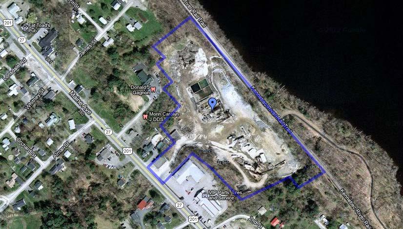
4 Location Map 4

5 Assessment Information 5

6 6
7 Municipal Information Real Estate Auction Parcel #7-6 Williams Street, Farmingdale, Maine 2012/13 Mill Rate $ 13.8 Per $1, Percent of Valuation at Market 87% Tax Map 33, Lot /13 TAX VALUE: Land $ 119, Building 216, Total Value $ 335, /13 ANNUAL REAL ESTATE TAXES: $ 4, REAL ESTATE TAXES DUE: Current PERSONAL PROPERTY TAX VALUE: To be reassessed next year. ANNUAL PERSONAL PROPERTY TAXES: To be reassessed next year. PERSONAL PROPERTY TAXES DUE: Current PUBLIC WATER DUE: $ 2,229.97* as of 5/16/13 PUBLIC SEWER DUE: $ * as of 5/16/13 *A new public water/sewer bill will be out in July for the months of April, May, and June. Tax Map 33, Lot /13 TAX VALUE: Land $ 5, /13 ANNUAL REAL ESTATE TAXES: $ REAL ESTATE TAXES DUE: Current ZONING: General Development Zone (GD) & partially in Shoreland Zone Sales Tax: Purchaser will be responsible to pay at closing a 5% State of Maine Sales Tax on the value of the personal property being sold with the real estate and included in the high bid price. The value of the personal property that will be subject to the 5% sales tax will be determined by multiplying 17% against the purchase price for the real estate and personal property. Example: Purchase Price X.17 = Personal Property Value X.05 = Sales Tax Amount Due At Closing At closing, please make check payable to the Keenan Auction Company. The above information was obtained from the Farmingdale Town Hall. For further details on municipal information please contact the Town Hall at
8 Zoning Information 8

9 9


10 10
11 Deed Description Auction Parcel #7 - Maine Avenue, Farmingdale, PARCEL ONE A certain lot or parcel of land with the buildings thereon and improvements thereto situated in Farmingdale, County of Kennebec and State of Maine, bounded and described as follows: Beginning at a ¼ inch iron rod set capped "Clunie" on the southerly line of land now or formerly of Richard P. Butler and Barbara C. Butler, reference deed recorded in Kennebec County Registry of Deeds in Book 1367, Page 354, said iron rod being N 77 51' 33" E and feet as measured along the southerly line of land of said Butler from the intersection of the northerly right of way line of Second Street, so-called, with the northeasterly right of way line of Maine Avenue, all as shown on a plan entitled "Plan of Standard Boundary Survey, Richard P. Butler & Barbara C. Butler, 359 Maine Avenue, Farmingdale, Maine" dated September 1993 by Thayer Engineering Company, Farmingdale, Maine; thence N 77 51' 33" E along land now or formerly of one Swett, reference deed recorded in said Registry of Deeds in Book 588, Page 413, and along the northerly line of a 20 foot wide driveway a distance of feet to a 1 inch iron pipe found and land now or formerly of Town of Farmingdale, formerly of one Sverdlik, reference deed recorded in said Registry of Deeds in Book 865, Page 418; thence N 21 16' 27" W along land of said Town of Farmingdale a distance of feet to land of Grantor, reference deed recorded in said Registry of Deeds in Book 1490, Page 535; thence N 85 56' 27" W along land of Grantor, a distance of feet to a ¼ inch iron rod set capped "Clunie"; thence S 26 30' 00" E along land being retained by said Butler a distance of feet to the point of beginning. Bearings are based upon a plan entitled "Plan of Goodine & Cross Properties, Farmingdale, Maine", dated February 7, 1959, recorded in the Kennebec County Registry of Deeds in Plan Book 22, Page 7. Said plan is oriented to a 1959 magnetic observation. Being the same premises conveyed to the Grantor herein by Richard P. Butler, et al by Quitclaim Deed dated June 10, 1994 and recorded in the Kennebec County Registry of Deeds in Book 4713, Page 293. PARCEL TWO A certain lot or parcel of land, with the buildings thereon, situated in said Farmingdale and bounded and described as follows: Beginning in the East line of Maine Avenue at a point marked by a maple tree and an iron rod located 100 feet southerly from the South line of a street identified as Edmund Street on a plan of River Park filed at Kennebec Registry of Deeds, Plan Book 2, Page 31, said point of beginning also being the Southwest corner of land now or formerly of St. Pierre; thence North 63-30' East in St. Pierre's South line a distance of 350 feet to the Southeast corner of lot 87 as delineated on said plan of River Park; thence Northerly parallel with the East line of Maine Avenue a distance of 100 feet to the Northeast corner of said lot 87; thence at right angles and running North 63-30' East in the North line of Lots 88 to 96 inclusive as delineated on said Plan of River Park a distance of 260 feet to the Northeast corner of said lot 96; thence at right angles and running Southerly parallel with the East line of Maine Avenue a distance of 100 feet to the Southerly corner of said lot 96; thence at right angles and running North 63-30' East a distance of 90 feet, more or less, to the West line of land now or formerly of Maine Central Railroad; thence Southerly along the West line of said Railroad land a distance of 710 feet, more or less, to the North line of land formerly owned by American Ice Company, now or formerly said to be the property of the Town of Farmingdale, which said line has sometimes been referred to as the 11
12 "Mayo Line"; thence Westerly in said Ice Company line (or Mayo Line) a distance of feet to the Northeast corner of land now or formerly of Cross' Flowers, Inc. now or formerly of Butler Twins, said corner being marked by an iron pipe bound situated 130 feet distant and North 21 20' West from the North line of the former American Ice Company right of way; thence continuing on the same course of North 86 00' West in the said Mayo line and in the North line of said land formerly of Cross' Flowers, Inc., a distance of feet to a corner; thence by an interior angle of ' and running North 34 20' West a distance of feet to the Northeast corner of land formerly of Burton M. Cross, or Cross' Flowers, Inc.; thence South 63 30' West and Extending 229 feet to an iron pipe in the East line of Maine Avenue and near the North side of a private roadway, said iron pipe being in the Northwest corner of land conveyed by Louis Grondin to Burton M. Cross by deed of July 10, 1943, recorded in Kennebec Registry of Deeds, Book 800, Page 355; Thence at a right angle in the East line of Maine Avenue a distance of 231 feet to the point of beginning. The bounds of said land being more specifically delineated on a survey plan of the same filed at Kennebec Registry of Deeds, Plan Book 22, Page 7. Excepting and reserving the land conveyed to Walter and Meredith Tobey. This conveyance is made subject to an Easement from William S. Williams, President to New England Telephone and Telegraph Company and Central Maine Power Company dated April 1, 1982 and recorded in the Kennebec County Registry of Deeds in Book 2462, Page 64. Being the same premises conveyed to the Grantor herein by Norma A. Williams and William S. Williams by deed dated April 2, 1969 and recorded in the Kennebec County Registry of Deeds in Book 1490, Page 535. PARCEL THREE Also conveying that certain real estate situated in said Farmingdale, in the County of Kennebec and State of Maine more particularly described as being the old Town gravel pit shown on tax Map 33, Lot 21. Being the same premises conveyed to Grantor herein by The Inhabitants of the Municipality of Farmingdale by deed dated August 20, 1975 and recorded in the said Registry of Deeds in Book 2893, Page 57. Excepting from the above described parcel the property conveyed to Lawrence J. and Eleanor H. Dupont by deed dated January 10, 2002 and recorded in the Kennebec County Registry of Deeds in Book 6802, Page 118. PARCEL FOUR A lot or parcel of land in the Town of Farmingdale, Kennebec County, Maine, consisting of several lots and portions thereof as shown on a plan entitled River Park by J. H. Burleigh, C. E. dated September 1898, and recorded in the Kennebec County Registry of Deeds (hereinafter KCRD) Plan Book 2, Page 31, being a part of land quitclaimed to William S. Williams Construction Co., Inc., by deeds in KCRD Book 841, Page 603 and Book 1439, Page 623, said parcel being more particularly described as follows: Beginning at an iron pipe found on the easterly side of Riverside Street (a paper street) and the southwesterly corner of Lot No. 110 as shown on said plan; thence running northwesterly along the easterly side of said Riverside Street about 31 feet to a point which lies perpendicularly opposite and 40 feet easterly of the midpoint of the easterly line of Lot No. 55; thence running southwesterly across the width of Riverside Street 40 feet to the midpoint of said Lot No. 55 and continuing in that same direction across the middle of Lots No. 55, 56, 57 and 58 and additional distance of 80 feet for a total distance of about 120 feet; thence running southeasterly along the westerly side of said Lot No. 58 about 50 feet to the southwest corner of said Lot No. 56; thence running northeasterly along the southerly line of said Lot No. 58 about 20 feet to the southeasterly corner 12
13 thereof; thence running southeasterly along the westerly line of Lot No. 80 about 100 feet to its southwesterly corner and continuing in that same direction an additional 20 feet to the centerline of Edmund Street (a paper street at this locus but now known as Merrill Avenue along the developed portion westerly hereof); thence running northeasterly along the centerline of Edmund Street about 80 feet to the intersection of the centerline of said Riverside Street; thence running southeasterly along the centerline of said Riverside Street about 120 feet to its southerly terminus as shown on Plan of Goodine & Cross Properties by John L. Coffins, dated February 7, 1959, and recorded in KCRD Plan Book 22, Page 7; thence running northeasterly about 70 feet to the land formerly of the Maine Central Railroad, Now State of Maine, as shown on Right-of Way and Track Map V.I.52 dated June 30, 1916; thence running northwesterly along said railroad right-of-way about 270 feet to the southeasterly corner of said Lot No. 110; thence running southwesterly along the southerly line of said Lot No. 110 about 80 feet to the iron pipe at the point of beginning. Meaning and intending to describe all of Lots No. 80, 81, and 82 plus the southerly one-half of lots No. 55, 56, 57 and 58 plus any rights in the paper streets contained therein and additional land situated between said Riverside Street and railroad r/w. 13
14 Multi-Sector General Permit 14
15 15
16 16
17 Air Emission License 17
18 18
19 19
20 20
21 21
22 22
23 23
24 24
25 25
26 26
27 27
28 28
29 29
30 30
31 31
32 DISCLAIMER ATTENTION PROSPECTIVE BIDDER THE SITE AND IMPROVEMENT DESCRIPTION INFORMATION SET FORTH IN THIS PROPERTY INFORMATION PACKAGE IS BELIEVED TO BE CORRECT AND COMPLETE. HOWEVER, THE KEENAN AUCTION COMPANY AND THE SELLER OF THIS PROPERTY AND ITS AGENTS/REPRESENTATIVES MAKE NO WARRANTIES AS TO THE ACCURACY, TRUTHFULNESS AND COMPLETENESS OF THIS INFORMATION. PRIOR TO THE AUCTION, PROSPECTIVE BIDDERS SHOULD MAKE SUCH INVESTIGATION, AS THEY DEEM APPROPRIATE. 32
33 33
34 34
35 35
Tax Map & Property Information Location Map Assessment Information Municipal Information Zoning Information...
 Table of Contents Parcel #5 5.99+/- Acres Office/Warehouse Buildings 28-30 Gordon Drive Rockland, Maine Keenan Auction Company Tax Map & Property Information... 1 Location Map... 2 Assessment Information...
MUNICIPAL QUITCLAIM DEED
 DRAFT MUNICIPAL QUITCLAIM DEED The INHABITANTS OF THE TOWN OF WARREN, a body corporate and politic, located at Warren, Knox County, Maine, for consideration paid, Release to, whose mailing address is,
ALTA COMMITMENT FOR TITLE INSURANCE SCHEDULE A ISSUED BY FIRST AMERICAN TITLE INSURANCE COMPANY
 SCHEDULE A Transaction Identification Data for reference only: Issuing Agent: Best Homes Title Agency, LLC Issuing Office: 4949 Plainfield Avenue NE, Grand Rapids, Michigan 49525 Telephone: (616) 885-9027
OFFICIAL SUMMARY OF AN ORDINANCE TO CONVEY CERTAIN RAMSEY COUNTY PARK AND OPEN SPACE LANDS TO THE CITY OF MAPLEWOOD.
 OFFICIAL SUMMARY OF AN ORDINANCE TO CONVEY CERTAIN RAMSEY COUNTY PARK AND OPEN SPACE LANDS TO THE CITY OF MAPLEWOOD. This ordinance authorizes the conveyance of park and open space land owned by Ramsey
QUITCLAIM DEED CR 202 THE STATE OF TEXAS KNOW ALL MEN BY THESE PRESENTS: COUNTY OF WILLIAMSON
 QUITCLAIM DEED CR 202 THE STATE OF TEXAS KNOW ALL MEN BY THESE PRESENTS: COUNTY OF WILLIAMSON That WILLIAMSON COUNTY, TEXAS, hereinafter referred to as Grantor, whether one or more, for and in consideration
Keenan Auction Company
 Keenan Auction Company PROPERTY INFORMATION PACKAGE Our 6,500 th Auction Real Estate Foreclosure Auction 13-322 Ranch Style Home 1674 North Belfast Ave., Vassalboro, Maine Tuesday, December 10, 2013 at
EASEMENT DEED. 2) Thence N 60º12 36 W through said Parcel 1 a distance of Two Hundred Ninety- Five and 97/100 (295.97) feet to a point;
 Thence N 60º12 36 W through said Parcel 1 a distance of Two Hundred Ninety- Five and 97/100 (295.97) feet to a point;") EASEMENT DEED TALL TREES CONSTRUCTION CORP., a Maine corporation having a mailing address of 30 Preservation Drive, Falmouth, Maine 04105 (the "Grantor") for consideration paid, grants to the TOWN OF FALMOUTH,
EASEMENT DEED TALL TREES CONSTRUCTION CORP., a Maine corporation having a mailing address of 30 Preservation Drive, Falmouth, Maine 04105 (the "Grantor") for consideration paid, grants to the TOWN OF FALMOUTH,
PROPERTY INFORMATION PACKAGE
 PROPERTY INFORMATION PACKAGE Our 7,537 th Auction Real Estate Foreclosure Auction 17-39 Split Level Home 32+/- Acres 3859 (f/k/a 3857) Broadway, Kenduskeag, ME Wednesday, March 22, 2017 at 1:30PM February
Village of Mantua, Ohio ORDINANCE
 AN ORDINANCE AUTHORIZING THE MAYOR TO EXECUTE A LEASE / OPTION TO PURCHASE AGREEMENT WITH THE PORTAGE PARK DISTRICT FOR THE HEADWATERS TRAIL WEST OF STATE ROUTE 44, AND DECLARING AN EMERGENCY. WHEREAS,
CONDITIONS OF SALE. The conditions of the present public sale are as follows:
 Prepare in duplicate. Post copy during sale and then give it to Purchaser. The conditions of the present public sale are as follows: CONDITIONS OF SALE 1. The property to be sold is a tract of improved
AN ACT. The General Assembly of the Commonwealth of Pennsylvania hereby enacts as follows:
 CONVEYANCES - COMMONWEALTH PROPERTY IN LIGONIER BOROUGH, WEST MORELAND COUNTY; CITY OF CONNELLSVILLE, FAYETTE COUNTY; CITY OF ALLENTOWN, LEHIGH COUNTY; BENSALEM TOWNSHIP, BUCKS COUNTY, AND SUSQUEHANNA
THE GENERAL ASSEMBLY OF PENNSYLVANIA SENATE BILL AN ACT
 PRINTER'S NO. THE GENERAL ASSEMBLY OF PENNSYLVANIA SENATE BILL No. INTRODUCED BY VANCE, APRIL, 00 REFERRED TO STATE GOVERNMENT, APRIL, 00 Session of 00 AN ACT 0 0 Authorizing the Department of General
CONVEYANCE - COMMONWEALTH PROPERTY IN THE BOROUGH OF EAST STROUDSBURG, MONROE COUNTY Act of Jul. 1, 2016, P.L., No. 65 Cl.
 CONVEYANCE - COMMONWEALTH PROPERTY IN THE BOROUGH OF EAST STROUDSBURG, MONROE COUNTY Act of Jul. 1, 2016, P.L., No. 65 Cl. 85 An Act Authorizing the Department of General Services, with the approval of
AGENDA UPDATE ECONOMIC DEVELOPMENT & FINANCE STANDING COMMITTEE MEETING MONDAY, AUGUST 10, 2015 III. COMMITTEE AGENDA
 AGENDA UPDATE ECONOMIC DEVELOPMENT & FINANCE STANDING COMMITTEE MEETING MONDAY, AUGUST 10, 2015 III. COMMITTEE AGENDA REVISED ITEM NO. 4 150217.ORDINANCE: VACATION VILLAGE AREAS 1 AND 2A Synopsis: A revised
DISTRICT. Huntington Beach. FIM 40-40C-3 APN and
 RECORDING REQUESTED BY W HEN RECORDED MAIL TO SOUTHERN CALIFORNIA EDISON COMPANY 2131 WALNUT GROVE AVENUE 2 ND FLOOR GO3 ROSEMEAD, CA 91770 Attn: Title and Real Estate Services SPACE ABOVE THIS LINE FOR
SALE & BARRINGTON STREET HALIFAX, NS PRIME SOUTH END HISTORIC BUILDING AND VACANT LOT 7,151 SF 2,607 SF
 FOR SALE 1265-1271 & 1273-1275 BARRINGTON STREET HALIFAX, NS PRIME SOUTH END HISTORIC BUILDING AND VACANT LOT 7,151 SF 2,607 SF BRIAN WOODS, ABR Real Estate Advisor 902.407.2492 brianwoods@kwcommercial.com
DEPARTMENT OF COMMUNITY DEVELOPMENT SERVICES. Economic Development Division. m e m o r a n d u m
 DEPARTMENT OF COMMUNITY DEVELOPMENT SERVICES Economic Development Division m e m o r a n d u m TO: FROM: Mayor Diane Wolfe Marlin and City Council Members John A. Schneider, MPA, Community Development
In Rem Foreclosure of Tax Liens By Lafayette County For Tax Years
 In Rem Foreclosure of Tax Liens By Lafayette County For Tax Years 2007-2011 Properties owned by Lafayette County, WI Sealed Bid Auction Date: November 13, 2015 Sealed Bid Auction Time: 11:00 a.m. Sealed
IIIlIIIIII IllIllhllIllIllIll III Ill Sacramento County Recorder David Villanueva,-Clerk/Recorder
 Record for the Benefit of the City of Sacramento - Fee Exempt Pursuant to Government Code Section 6103 and 27383. Transfer Tax exempt under Revenue and Taxation Code 11921, When Recorded, Mail to: Office
COMMONWEALTH OF MASSACHUSETTS
 SPECIAL TOWN MEETING October 1, 2018 COMMONWEALTH OF MASSACHUSETTS HAMPDEN, SS To Ms. Kim Batista, Town Clerk of the Town of Ludlow in said County: GREETINGS: In the name of the Commonwealth of Massachusetts,
PROPERTY INFORMATION PACKAGE
 AMG AUCTION MARKETING GROUP PROPERTY INFORMATION PACKAGE Thank you for your interest in the Auction. We have compiled the following Property Information to assist you in your research. Please understand
Old Republic National Title Insurance Company
 Old Republic National Title Insurance Company COMMITMENT FOR TITLE INSURANCE SCHEDULE A File No: 59425 Upper River Area Parcels Supplemental No. 2 1. Effective Date: June 02, 2013, 7:00 a.m. Issue Date:
APPLICATION TO REGISTER NOTICE OF AN AGREEMENT THE LAND TITLES ACT SECTION 74
 26 th May 1981 Campeau - City of Kanata 40% Open Space Agreement APPLICATION TO REGISTER NOTICE OF AN AGREEMENT THE LAND TITLES ACT SECTION 74 TO: THE LAND REGISTRAR FOR THE LAND TITLES DIVISION OF OTTAWA-CARLETON
RATE AND METHOD OF APPORTIONMENT FOR COMMUNITY FACILITIES DISTRICT NO. 4 - MAINTENANCE OF THE CITY OF MORENO VALLEY
 CFD No. 4 Maintenance Page 1 RATE AND METHOD OF APPORTIONMENT FOR COMMUNITY FACILITIES DISTRICT NO. 4 - MAINTENANCE OF THE CITY OF MORENO VALLEY A Special Tax as hereinafter defined shall be levied on
FORECLOSURE DEED. MASCOMA SAVINGS BANK, as successor by merger to Connecticut River Bank, N.A.
 FORECLOSURE DEED MASCOMA SAVINGS BANK, as successor by merger to Connecticut River Bank, N.A. with a mailing address of P.O. Box 4399, White River Junction, VT 05001, holder of several commercial mortgages,
WHEREAS, the Petition is in all ways in complete compliance with the provisions of the Act; and,
 ORDINANCE NO. 15,700 AN ORDINANCE continuing the Downtown Des Moines Self-Supported Municipal Improvement District pursuant to the provisions of Chapter 386, Code of Iowa; and providing for the continuation
LIST OF TAX FORFEITED LAND # FOR SALE TO PUBLIC
 LIST OF TAX FORFEITED LAND #218-1 FOR SALE TO PUBLIC Residential Properties RADON WARNING STATEMENT The Minnesota Department of Health strongly recommends that ALL homebuyers have an indoor radon test
Sketch & Legal Description of Mitigation Bank and Ingress/Egress Access Easements
 Appendix H: Sketch & Legal Description of Mitigation Bank and Ingress/Egress Access Easements Tippen Bay Wetland Mitigation Bank DeSoto County, Florida Prepared by: September, 2017 Original file
CHAPTER XIX ANNEXATION ARTICLE 1. ANNEXATION
 CHAPTER XIX ANNEXATION ARTICLE 1. ANNEXATION 19.0101 JABORSKY ADDITION: WHEREAS, The City of Belfield pursuant to Section 40-51.2-07 of the North Dakota Century Code has amended having passed a Resolution
Exhibit A PROPERTY: LEGAL DESCRIPTION AND MAP. (Included on following pages)
") Exhibit A PROPERTY: LEGAL DESCRIPTION AND MAP (Included on following pages) Exhibit A A-1 The Dow Chemical Company Trust Lands Lease RBF CONSULTING, a Company of Michael Baker International 500 Ygnacio
Exhibit A PROPERTY: LEGAL DESCRIPTION AND MAP (Included on following pages) Exhibit A A-1 The Dow Chemical Company Trust Lands Lease RBF CONSULTING, a Company of Michael Baker International 500 Ygnacio
LEGAL NOTICE LEGAL DESCRIPTION SEE EXHIBIT A
 LEGAL NOTICE PUBLIC AUCTION OF CERTAIN PROPERTY BY THE BOARD OF EDUCATION OF THE LAKEWOOD CITY SCHOOL DISTRICT THAT IS NO LONGER NEEDED FOR SCHOOL PURPOSES Notice. Under the provisions of Ohio R.C. 3313.41,
Concept Planned Unit Development Memorandum. Duke Realty is requesting Park 81 be considered for a Planned Unit Development
 Dtike 1550 Utica Avenue South Suite 420 Minneapolis, MN 55416 952.543.2900 To: From: Maple Grove City Planner Bill Shank Duke Realty Date: December 11, 2017 Subject: Concept Planned Unit Development Memorandum
FIFTH AMENDMENT OF DECLARATION OF DEED RESTRICTIONS AND DEDICATIONS FOR PINEHURST ESTATES (A Clatsop County, Oregon Subdivision)
") After Recording Return To: W. Louis Larson 990 Astor Street Astoria, OR 97103 FIFTH AMENDMENT OF DECLARATION OF DEED RESTRICTIONS AND DEDICATIONS FOR PINEHURST ESTATES (A Clatsop County, Oregon Subdivision)
After Recording Return To: W. Louis Larson 990 Astor Street Astoria, OR 97103 FIFTH AMENDMENT OF DECLARATION OF DEED RESTRICTIONS AND DEDICATIONS FOR PINEHURST ESTATES (A Clatsop County, Oregon Subdivision)
COUNTY OF CHISAGO, STATE OF MINNESOTA
 OFFICE OF COUNTY AUDITOR-TREASURER COUNTY OF CHISAGO, STATE OF MINNESOTA NOTICE OF EXPIRATION OF REDEMPTION To all persons interested in the lands hereinafter described: You are hereby notified that the
The General Assembly of the Commonwealth of Pennsylvania hereby enacts as follows:
 CONVEYANCE - COMMONWEALTH PROPERTY LOCATED IN SOLEBURY TOWNSHIP, BUCKS COUNTY AND CITY OF PHILADELPHIA Act of Oct. 8, 2008, P.L. 1105, No. 94 Cl. 85 AN ACT Authorizing the Pennsylvania Fish and Boat Commission
MEMORANDUM. Mayor and City Council. Warren Hutmacher, City Manager. Date: February 11, 2013
 MEMORANDUM To: From: Mayor and City Council Warren Hutmacher, City Manager Date: February 11, 2013 Subject: Approval of an Intergovernmental agreement by and between the City of Dunwoody and DeKalb County
Selling for Estate of Alan Hohnstein, Tomahawk, AB May 9, 2018
 Selling for Estate of Alan Hohnstein, Tomahawk, AB May 9, 2018 Real Estate Sells at Noon 51516 Range Road 55, Tomahawk, Parkland County SE31-51-5-W5-159.2 acres home, shop & barn OPEN HOUSE 1 pm to 3 pm
LEGAL DESCRIPTIONS - REVIEW
 J. K. Mucklestone, B.A. Sc., O.L.S., P. LEGAL DESCRIPTIONS - REVIEW The following notes should be helpful to indicate types and form of legal descriptions. They were prepared many years ago and in many
Request for Proposals to Purchase Package. Nathan Hale Hall (Formerly Nathan Hale Hotel) 833 Main Street Willimantic, Connecticut SB 09-06
 833 Main Street Willimantic, Connecticut SB 09-06") Nathan Hale Hall (Formerly Nathan Hale Hotel) 833 Main Street Willimantic, Connecticut SB 09-06 Offer Due By: January 29, 2010 Issued By: State of Connecticut Department of Public Works 165 Capitol Avenue
Nathan Hale Hall (Formerly Nathan Hale Hotel) 833 Main Street Willimantic, Connecticut SB 09-06 Offer Due By: January 29, 2010 Issued By: State of Connecticut Department of Public Works 165 Capitol Avenue
ALTA COMMITMENT FOR TITLE INSURANCE SCHEDULE A ISSUED BY FIRST AMERICAN TITLE INSURANCE COMPANY
 SCHEDULE A Transaction Identification Data for reference only: Issuing Agent: Best Homes Title Agency, LLC Issuing Office: 4949 Plainfield Avenue NE, Grand Rapids, Michigan 49525 Telephone: (616) 885-9027
As Introduced. 131st General Assembly Regular Session H. B. No
 131st General Assembly Regular Session H. B. No. 239 2015-2016 Representative Sears A B I L L To amend section 5120.092 and to enact section 5120.80 of the Revised Code to allow the Director of Budget
RESOLUTION NO
 RESOLUTION NO. 2009 233 A RESOLUTION OF THE CITY COUNCIL OF THE CITY OF ELK GROVE QUITCLAIMING A PORTION OF ABANDONED EAST STOCKTON BOULEVARD TO ELK GROVE V PARTNERS, LLC PURSUANT TO AN AGREEMENT WHEREAS,
Sec moves to amend H.F. No as follows: 1.2 Page 5, after line 31, insert:
 1.1... moves to amend H.F. No. 1586 as follows: 1.2 Page 5, after line 31, insert: 1.3 "Sec. 6. Minnesota Statutes 2018, section 282.01, subdivision 4, is amended to read: 1.4 Subd. 4. Sale; method; requirements;
TOWN OF WAREHAM TAX TITLE AUCTION 13 TYLER AVENUE (PARCEL: ) TERMS AND CONDITIONS OF SALE. 1. Agreement to Purchase; Purchase Price: I/We of
 TERMS AND CONDITIONS OF SALE. 1. Agreement to Purchase; Purchase Price: I/We of") TOWN OF WAREHAM TAX TITLE AUCTION 13 TYLER AVENUE (PARCEL: 15-1028) TERMS AND CONDITIONS OF SALE 1. Agreement to Purchase; Purchase Price: I/We of (hereinafter, the Buyer(s) ), hereby acknowledge that
TOWN OF WAREHAM TAX TITLE AUCTION 13 TYLER AVENUE (PARCEL: 15-1028) TERMS AND CONDITIONS OF SALE 1. Agreement to Purchase; Purchase Price: I/We of (hereinafter, the Buyer(s) ), hereby acknowledge that
4 Lynwood Avenue, 6 Lynwood Avenue & 2 Clearview Avenue, Gloucester, MA Terms and Conditions of Sale
 CITY OF GLOUCESTER TAX TITLE AUCTION 4 LYNWOOD AVENUE (PARCEL: 219-30) 6 LYNWOOD AVENUE (PARCEL: 219-32) 2 CLEARVIEW AVENUE (PARCEL 219-31) TERMS AND CONDITIONS OF SALE 1. Agreement to Purchase; Purchase
FOR LEGAL DESCRIPTION, SEE EXHIBIT "A" ATTACHED HERETO AND MADE APART HEREOF.
 RECORDING REQUESTED BY SOUTHERN CALIFORNIA EDISON WHEN RECORDED MAIL TO SOUTHERN CALIFORNIA EDISON COMPANY Real Properties 2131 Walnut Grove Avenue, 2nd Floor Rosemead, CA 91770 Attn: Distribution/TRES
JOINT RESOLUTION OF THE CITY OF PORT JERVIS, ORANGE COUNTY, NEW YORK AND THE TOWN OF DEERPARK, ORANGE COUNTY, NEW YORK
 JOINT RESOLUTION OF THE CITY OF PORT JERVIS, ORANGE COUNTY, NEW YORK AND THE TOWN OF DEERPARK, ORANGE COUNTY, NEW YORK WHEREAS, the City of Port Jervis, in conjunction with the Town of Deerpark seeks to
INVITATION FOR PROPOSALS SALE OF REAL PROPERTY INSTRUCTIONS, TERMS AND CONDITIONS
 INVITATION FOR PROPOSALS SALE OF REAL PROPERTY INSTRUCTIONS, TERMS AND CONDITIONS The City Council of the City of Covington invites members of the general public to submit sealed bid proposals to purchase
CITY OF OCALA CITY COUNCIL REPORT Council Meeting Date: 06/06/17
 CITY OF OCALA CITY COUNCIL REPORT Council Meeting Date: 06/06/17 Subject: Large Scale Land Use Map Amendment Submitted By: David Boston Department: Growth Management STAFF RECOMMENDATION (Motion Ready):
8-1 SECTION 8 - SINGLE-DETACHED DWELLING- SECOND DENSITY ZONE - R2
 8-1 SECTION 8 - SINGLE-DETACHED DWELLING- SECOND DENSITY ZONE - R2 The following provisions shall apply in all SINGLE-DETACHED - DWELLING- SECOND DENSITY ZONES R2: No PERSON shall HEREAFTER USE any BUILDING,
CONDITIONS OF SALE CERTAIN PROPERTY B Y T H E B O A R D O F E D U C A T I O N O F T H E SOUTH EUCLID-LYNDHURST CITY SCHOOL DISTRICT
 CONDITIONS OF SALE O F CERTAIN PROPERTY B Y T H E B O A R D O F E D U C A T I O N O F T H E SOUTH EUCLID-LYNDHURST CITY SCHOOL DISTRICT The Board of Education of the South Euclid-Lyndhurst City School
ATTACHMENT B GRANT DEED. This deed is in satisfaction of the Eminent Domain Action Case No. GRANT DEED
 GRANT DEED RECORDING REQUESTED BY AND WHEN RECORDED MAIL TO: County of Orange County Executive Office CEO Real Estate 333 W. Santa Ana Blvd. Bldg. 10 Santa Ana, California 92701 AND MAIL TAX STATEMENTS
Springfield, New Hampshire Dartmouth Grant
 Springfield, New Hampshire Dartmouth Grant Springfield, New Hampshire Route 4A Stratford, New Hampshire Tax Map 2130, Lot 11 Stratford, New Hampshire Tax Map 2370, Lot 14 Troy,
Exhibit A: REAL ESTATE TRANSFER AGREEMENT
 Exhibit A: REAL ESTATE TRANSFER AGREEMENT This agreement is made between the City of Urbana, Illinois, a municipal corporation of the State of Illinois (the Seller ), and Homestead Corporation of Champaign-Urbana,
CITY COUNCIL STAFF REPORT
 -------- 3/14/17 COUNCIL AGENDA: 02/28/17 ITEM: 11.1(a) CITY COUNCIL STAFF REPORT File No. C16-029 Applicant William Mabry, Oakmont Senior Living Location 3550 San Felipe Road Existing Zoning A Agricultural
Genesee County Land Real Estate Bid Packet Griswold, Selden, & Thwing Road, LeRoy, New York Property inspection by appointment only!
 Real Estate Bid Packet Griswold, Selden, & Thwing Road, LeRoy, New York Property inspection by appointment only! Bids due by November 30th, 2016. Bids must be entered by parcel only! Aerial Map For Reference
in Book 10019, at Page 9432, 352 feet, more, or less, to the North right of way of 3350 South Street; thence West along said right of way 93 feet,
 Public notice is hereby given that the Millcreek Community Reinvestment Agency (the Agency ) will hold a public hearing on Tuesday, November 13, 2018, commencing at 7:30 p.m. or as soon thereafter as the
No approval of the Governor, to convey to the Historical and Genealogical
 712 Act 2000-97 LAWS OF PENNSYLVANIA SB 1468 No. 2000-97 AN ACT Amending the act of June 25, 1999 (P.L.205, No.27), entitled An act authorizing the Department of General Services, with the approval of
CITY OF NORTHVILLE FINAL REPORT HISTORIC DISTRICT BOUNDARIES
 CITY OF NORTHVILLE FINAL REPORT HISTORIC DISTRICT BOUNDARIES 2007 Background: In 2003 the Historic District Commission (HDC) undertook the task of revising the Historic District Boundaries in an effort
FILED: NEW YORK COUNTY CLERK 12/15/ :54 PM
 Rosenthal Affidavit Exhibit 1 NYC DEPARTMENT OF FINANCE OFFICE OF THE CITY REGISTER This page is part of the instrument. The City Register will rely on the information provided by you on this page for
An ordinance changing the zoning classification on the following properties:
 ORDINANCE NO. Page 9-27-16 An ordinance changing the zoning classification on the following properties: BEING Lots 1 through 5 in City Block C/7085 located at the southwest corner of Akron Street and McPherson
Bill 226 (Private) An Act respecting Ville de Shawinigan
 An Act respecting Ville de Shawinigan") SECOND SESSION THIRTY-SIXTH LEGISLATURE Bill 226 (Private) An Act respecting Ville de Shawinigan Introduced 11 December 2002 Passage in principle 19 December 2002 Passage 19 December 2002 Assented to 19
SECOND SESSION THIRTY-SIXTH LEGISLATURE Bill 226 (Private) An Act respecting Ville de Shawinigan Introduced 11 December 2002 Passage in principle 19 December 2002 Passage 19 December 2002 Assented to 19
SANjOSE CAPITAL OF SILICON VALLEY
 COUNCIL AGENDA: 10/20/15 ITEM: f. 3 CITY OF SANjOSE CAPITAL OF SILICON VALLEY CITY COUNCIL STAFF REPORT File No. C15-034 Applicant: Jim Rubnitz Location Southeast corner of Meridian Avenue and Fruitdale
Keenan Auction Company
 Keenan Auction Company PROPERTY INFORMATION PACKAGE Our 6,424 th Auction Real Estate Foreclosure Auction 13-237 Raised Ranch Style Home 21 Wardwell Rd., Orland, Maine Tuesday, August 27, 2013 at 3:30PM
CERTIFIED SURVEY MAP
 SCONSIN STATE PLANE N:389676.12 E:2130390.15 Center of Section 23 CERTIFIED SURVEY MAP 734.06' THE (PRITCHETTE) ORIGINAL PLAT OF ALL IN THE NW 1 4 OF THE SE 1 4 OF FRACTIONAL SECTION 23, T7N, R9E, IN THE
NOTICE OF TAX FORECLOSURE SALE Opening Bid $2, entered in the action entitled "COUNTY OF IREDELL vs. DORMAN DURANT LITTLE and spouse,
 Opening Bid $5,740.33 entered in the action entitled "COUNTY OF IREDELL vs. DORMAN DURANT LITTLE and spouse, JOY G. LITTLE, and all possible heirs and assignees of DORMAN DURANT LITTLE and spouse, JOY
City of Mt. Pleasant Mt. Pleasant, Michigan
 City of Mt. Pleasant Mt. Pleasant, Michigan MT. PLEASANT INDUSTRIAL PARK - SOUTH Protective Covenants November 11, 2013 October 1, 2013 PROTECTIVE COVENANTS MT. PLEASANT INDUSTRIAL PARK-SOUTH MT. PLEASANT,
.07:06 AM j) Title: Master Lease-Delete 0'' Property With: Sacramento Financing Authority Authorization: Reso
 Title: Master Lease-Delete 0'' Property With: Sacramento Financing Authority Authorization: Reso") Record for the Benefit of the City of Sacramento- Fee Exempt Pursuant to Government Code Section 6103 and 27383. When Recorded, Mail to: ell ~ ORIGINAL Accepted for Recording COPY-NOT CERTIFIED Office
Record for the Benefit of the City of Sacramento- Fee Exempt Pursuant to Government Code Section 6103 and 27383. When Recorded, Mail to: ell ~ ORIGINAL Accepted for Recording COPY-NOT CERTIFIED Office
MASTER SITE LEASE. by and between THE CITY OF SAN DIEGO. and the PUBLIC FACILITIES FINANCING AUTHORITY OF THE CITY OF SAN DIEGO.
 RECORDING REQUESTED BY AND ) WHEN RECORDED MAIL TO: ) ) Attn: Robert H. Olson, Esq. ) Squire, Sanders & Dempsey L.L.P. ) One Maritime Plaza, Suite 300 ) San Francisco, CA 94111 ) ) (Space above for Recorder
2014 Pine County Tax-Forfeit Land Auction Sale Terms and Conditions
 2014 Pine County Tax-Forfeit Land Auction Sale Terms and Conditions RESOLUTION BE IT HEREBY RESOLVED, that the parcels of land forfeited to the State for non-payment of taxes, appearing on the attached
DEPARTMENT OF BUILDING AND SAFETY
 DEPARTMENT OF BUILDING AND SAFETY INDEPENDENCE OFFICE BISHOP OFFICE P.O. Drawer Q 377 W. Line St. Independence, CA 93526 Bishop, CA 93514 Ph. (760) 878-0201 Ph. (760) 873-7858 Fax. (760) 878-2001 Fax.
ORDINANCE N0.18-ll6. WHEREAS, City has prepared a Service Plan for said tract which is attached as Exhibit "A" to this ordinance; &
 c: 0 ORDINANCE N0.18-ll6 AN ORDINANCE ANNEXING THE HEREINAFTER DESCRIBED TERRITORY TO THE CITY OF FORT STOCKTON, PECOS COUNTY, TEXAS, AND EXTENDING THE BOUNDARY LIMITS OF SAID CITY SO AS TO INCLUDE SAID
ORDINANCE NO. Z REZONING NO
 ORDINANCE NO. Z- 3960 REZONING NO. 2018-00014 AN ORDINANCE RELATING TO ZONING: AMENDING CERTAIN ZONING REGULATIONS SHOWN ON SHEET NO. 15 OF THE ZONING DISTRICT MAP INCORPORATED BY REFERENCE BY OVERLAND
IN THE DISTRICT COURT OF THE THIRD JUDICIAL DISTRICT OF THE STATE OF IDAHO, IN AND FOR THE COUNTY OF CANYON
 Gery W. Edson GERY W. EDSON, P.A. 250 South Fifth Street, Suite 820 P. O. Box 448 Boise, ID 83701-0448 Telephone: (208) 345-8700 Fax: (208) 389-9449 Email: gedson@gedson.com ID Bar No. 2984 Attorney for
Bid Basis ENERFO Orr Grain Inc, Momence IL Facilities
 Bid Basis ENERFO Orr Grain Inc, Momence IL Facilities We are presenting the Orr Grain Facilities and operations totaling 2,298,887-bushel storage capacity, Rail loading facility and Dried Distillers Grain
A portion of the land (surplus land), described in Exhibit A, is no longer needed for a state highway purpose.
, described in Exhibit A, is no longer needed for a state highway purpose.") TEXAS TRANSPORTATION COMMISSION DENTON County MINUTE ORDER Page 1 of 2 DALLAS District In the city of Northlake, DENTON COUNTY, on INTERSTATE 35W, the State of Texas (state) acquired certain land for a
TEXAS TRANSPORTATION COMMISSION DENTON County MINUTE ORDER Page 1 of 2 DALLAS District In the city of Northlake, DENTON COUNTY, on INTERSTATE 35W, the State of Texas (state) acquired certain land for a
Town of Mansfield SPECIAL TOWN MEETING
 Town of Mansfield SPECIAL TOWN MEETING November 13, 2018 7:00 PM MANSFIELD HIGH SCHOOL AUDITORIUM EAST STREET, MANSFIELD CALL TO ORDER: 7:00 PM MOTIONS Town of Mansfield Special Town Meeting November 13,
SHERIFF'S SALE. ALL those certain tracts of land situate in the Borough of Westfield, Tioga County, Pennsylvania, bounded and described as follows:
 No. 43-CV-2017 ALL those certain tracts of land situate in the Borough of Westfield, Tioga County, Pennsylvania, bounded and described as follows: TRACT NO. 1: Located on the North side of Stephenson Street
REVIEWED BY: Administrator Counsel Program Mgr.: Tiffany Schaufler Board Committee Engineer Other
 Minnehaha Creek Watershed District REQUEST FOR BOARD ACTION MEETING DATE: May 11, 2017 TITLE: Authorization to Grant a Temporary Easement to the City of Minnetrista RESOLUTION NUMBER: 17-034 PREPARED BY:
PURCHASE AND SALE AGREEMENT
 PURCHASE AND SALE AGREEMENT THIS AGREEMENT made this day of July, 2017, by and between JPMCC 2011- C5 APPLETREE MALL LLC, having an address at c/o Torchlight Loan Services, 475 5th Avenue, 10 th Floor,
Dact= Bk:31661 Ps: 116
 Dact= 33591 Bk:31661 Ps: 116 AMENDMENT TO THE MASTER DECLARATION OF COVENANTS, CONDITIONS AND RESTRICTIONS FOR DUNSTAN CROSSING [Submission of Project Phase IIIl CHAMBERLAIN CONSTRUCTION, INC., a Maine
;:ft{n Siegel, City Manager
 5/17/2016 03 City of San Juan Capistrano Agenda Report TO: FROM: Honorable Mayor and Members of the City Council ;:ft{n Siegel, City Manager SUBMITTED BY: Steve May, Public Works and Utilities Director
November 4, 2017 Short Notice Real Estate & Equipment Auction for Greg Grills & Renee Grills
 November 4, 2017 Short Notice Real Estate & Equipment Auction for Greg Grills & Renee Grills Real Estate Sells at Noon NE8-38-5-W5-98 acres, shop, livestock shelter, small home 54039 TWP RD 38-2 Alhambra,
DEPARTMENT OF TRANSPORTATION VACANT LAND FOR SALE 7,769 SQUARE FEET
 DEPARTMENT OF TRANSPORTATION VACANT LAND FOR SALE 7,769 SQUARE FEET LOCATED I-94 at N Howell St., St. Paul, MN Conveyance 2016-0076 C.S.: 6282 (94=392) 903 Parcel: 1 and 47 AVAILABLE FOR PURCHASE AT THE
RESOLUTION NO. FILE NO. T15-058
 RESOLUTION NO. A RESOLUTION OF THE COUNCIL OF THE CITY OF SAN JOSE APPROVING A VESTING TENTATIVE MAP, SUBJECT TO CONDITIONS, TO MERGE FOUR PARCELS INTO ONE PARCEL AND RESUBDIVIDE THE ONE PARCEL INTO NO
LEGAL NOTICE NOTICE OF FORECLOSURE SALE OF REAL AND PERSONAL PROPERTY
 LEGAL NOTICE NOTICE OF FORECLOSURE SALE OF REAL AND PERSONAL PROPERTY Reference is made to the Mortgage, Assignment of Leases and Rents and Security Agreement from APPLETREE MALL ASSOCIATES LLC, a Massachusetts
AIR ONE. 829 HULL ROAD Ormond Beach, Florida BENCHMARK #1 EL NAIL IN POWER POLE EASTERLY RIGHT-OF-WAY LINE TOMOKA AIRPORT ROAD (UR) HULL ROAD
 HULL ROAD") NORTH LINE LOT 2 SOUTH LINE LOT 1 S75 46'55"E 2 NORTH LINE LOT 3 SOUTH LINE LOT 2 N75 43'32"W(UR) S75 43'32"E(D) N75 43'32"W(URD) NORTH LINE LOT 1 SOUTH LINE LOT 12 225.15'(M)225'(UR) P.O.R. PARCELS II
NORTH LINE LOT 2 SOUTH LINE LOT 1 S75 46'55"E 2 NORTH LINE LOT 3 SOUTH LINE LOT 2 N75 43'32"W(UR) S75 43'32"E(D) N75 43'32"W(URD) NORTH LINE LOT 1 SOUTH LINE LOT 12 225.15'(M)225'(UR) P.O.R. PARCELS II
CONVEYANCES - COMMONWEALTH PROPERTY IN MULTIPLE MUNICIPALITIES Act of Jul. 2, 2014, P.L. 881, No. 100 Cl. 85 An Act
 Pennsylvania General Assembly http://www.legis.state.pa.us/cfdocs/legis/li/uconscheck.cfm?txttype=htm&yr=2014&sessind=0&smthlwind=0&act=100 08/04/2014 10:34 AM Home / Statutes of Pennsylvania / Unconsolidated
AGENDA SCARBOROUGH TOWN COUNCIL REGULAR MEETING 7:00 P.M. WEDNESDAY JUNE 17, 2009
 AGENDA SCARBOROUGH TOWN COUNCIL REGULAR MEETING 7:00 P.M. WEDNESDAY JUNE 17, 2009 Order No. 09-88. Move to approve the acceptance of the fee of the land identified on Scarborough Tax Map 22, Lot 109-A
Keenan Auction Company
 Keenan Auction Company PROPERTY INFORMATION PACKAGE Our 6,584 th Auction Real Estate Foreclosure Auction 14-46 Log Cabin 4.4+/- Acres View Sugarloaf Region 178 New Portland Hill Rd., New Portland, Maine
Clerk-Recorder Sacramento, CA FIFTH AMENDMENT TO MASTER SITE LEASE. by and between the CITY OF SACRAMENTO. and the
 When Recorded Return to: ORIGINAL Accepted for Recording COPY-NOT CERTIFIED Sean B. Mick, Project Manager 'JUN 14 208 Orrick, Herrington & Sutcliffe LLP 400 Capitol Mail Sacramento County Suite 3000 Clerk-Recorder
CITY OF ANDOVER NEIGHBORHOOD REVITALIZATION PLAN
 CITY OF ANDOVER NEIGHBORHOOD REVITALIZATION PLAN Adopted August 25, 2015 Expires December 31, 2018 Attorney General Office: Adopted CITY OF ANDOVER, KANSAS NEIGHBORHOOD REVITALIZATION PLAN PURPOSE This
CASCADE CHARTER TOWNSHIP
 CASCADE CHARTER TOWNSHIP Ordinance #10 of 1997 As amended by Ord No 8 of 2000; May 31, 2000 As amended by Ord No 17 of 2000; October 18, 2000 As amended by Ord No 8 of 2003; June 11, 2003 As amended by
DEED AND DEDICATION FOR PUBLIC RIGHT OF WAY
 TO : BOARD OF DIRECTORS FROM : GARY PLATT, EXEC. DIRECTOR BUSINESS AND OPERATIONS SUBJECT : CITY OF STANWOOD CONSTRUCTION EASEMENT AND RIGHT-OF-WAY DEDICATION DATE : MARCH 17, 2009 TYPE : ACTION NEEDED
FIDELITY NATIONAL TITLE INSURANCE COMPANY COMMITMENT FOR TITLE INSURANCE SCHEDULE A
 COMMITMENT FOR TITLE INSURANCE SCHEDULE A File No. PRO-15-2178W REVISION D 1. Effective Date: 2. Policy or policies to be issued: Amount (a) ALTA Owner s Policy: (6-17-06) ALTA Homeowner s Policy To Be
MONDAY, JULY 16, :00 P.M. * 4. Approve, as submitted, minutes of regular meeting held July 2, 2012.
 MONDAY, JULY 16, 2012 8:00 P.M. 1. Pledge of Allegiance led by Village Clerk Marlene Williams. 2. Call meeting to order and roll call. 3. Approve Consent Agenda. * 4. Approve, as submitted, minutes of
A favorable recommendation to the City Council is requested.
 To: Sycamore Plan Commission From: Brian Gregory, City Manager Date: October 8, 2015 Re: October 12, 2015 Plan Commission Meeting The Plan Commission has two action items. A. Consideration of a request
Hume NY Real Estate Bid Packet 7488 County Road 3, Hume, New York Property inspection by appointment only!
 Real Estate Bid Packet 7488 County Road 3, Hume, New York Property inspection by appointment only! Bids on Real Estate due by March 31st, 2017 Offering: 113+ acres of land in Hume, Allegany County, New
DEED TO DEVELOPMENT RIGHTS CONSERVATION RESTRICTIONS
 DOC s 00000246 Bk5 319 Pss 29 DEED TO DEVELOPMENT RIGHTS A N D CONSERVATION RESTRICTIONS THIS WARRANTY DEED made this day of ^XP/'f ( 2018, by and between CATHERINE CONTE, hereinafter referred to as the
Mortgagee s Sale of Real Estate at Auction
 RPROPERTY INFORMATION PACKAGE Thank you for your interest in the Auction. We have compiled the following Property Information to assist you in your research. Please understand that this package is for