14+/- Acres Zoned Commercial
|
|
|
- Beverly Black
- 5 years ago
- Views:
Transcription


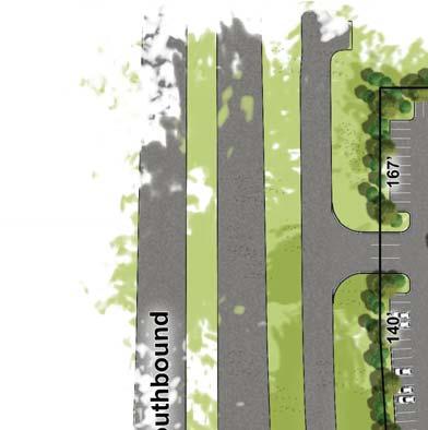
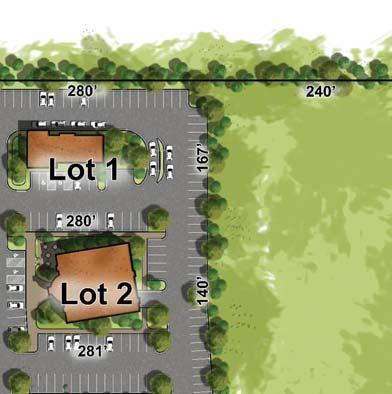
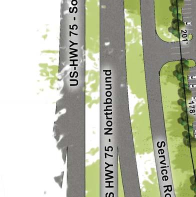
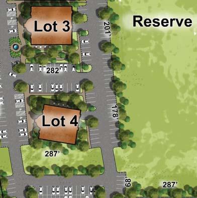
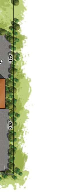
1 14+/- Acres Zoned Commercial Hwy 75 & 151st St, Glenpool OK - Commercial Land For Sale School and Sports Park Points of Interest 1,269+/- Frontage Developing Area Utilities Present Billboards Allowed Zoned Commercial At high traffic intersection of Hwy 75 and Hwy 69 Frontage on from Hwy 75 with service road access Easy access to Tulsa, Glenpool, Jenks and Bixby 2 means of ingress and egress Contact: Nick Probst C F Nick@CRATulsa.com C ORPORATE REALTY ADVISORS LLC 3150 E 41st St, Suite 102 Tulsa, OK


2 14+/- Acres Zoned Commercial Hwy 75 & 151st St, Glenpool OK - Commercial Land For Sale New Housing 14 Acres Zoned Commercial New Housing Commercial Lots Points of Interest Near Other Developments Utilities Present Billboards Allowed High Traffic Intersection Future Development Future Development Contact: Nick Probst C F Nick@CRATulsa.com C ORPORATE REALTY ADVISORS LLC 3150 E 41st St, Suite 102 Tulsa, OK


3
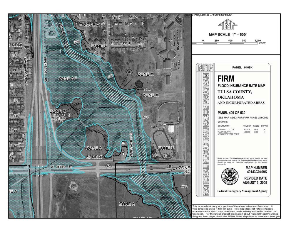
4 Tanner Consulting, L.L.C. Civil Engineering Architecture Land Planning Land Surveying Landscape Architecture 5323 South Lewis Ave. Tulsa, Oklahoma Ph (918) Fx (918) July 13, 2010 Mr. Nick Probst Corporate Realty Advisors, LLC Re: Brookover Tract, NE Corner of 151 st and Highway 75 Dear Mr. Probst At your request, our firm has evaluated the feasibility of removing portions of the acre Brookover tract from the mapped FEMA floodplain. The Brookover tract is located north of the northeast corner of the intersection of 151 st Street South and US Highway 75 in Glenpool, OK. The property can be found on the FEMA Flood Insurance Rate Map (FIRM) #40143C0409K dated August 3, Approximately acres of the tract is currently encumbered by Zone A (0.73 AC) and Zone AE (9.62 AC) floodplain designations. Approximately 0.10 acres at the northeast corner of the tract is designated as Floodway. These areas were estimated by graphical means, as there was not a survey available at the time of study. In order to calculate the required earthwork needed to remove a portion of the property from the FEMA Floodplain, our firm obtained 2 topographic information from the Indian Nations Council of Government (INCOG). With this information, we prepared multiple grading plans until we were able to balance the earthwork cut and fill quantities. Based on the method outlined above, we have estimated that roughly 17,000 cubic yards of material would need to be moved onsite in order to provide approximately 9.9 acres of property above the FEMA Floodplain. Assuming a $4.50/CY unit price for earthwork, the estimated cost of construction is $76,500, or approximately $0.18 per square foot of developable land. This is an estimate for construction only, and does not reflect cost for Surveying, Engineering or permitting through the City of Glenpool, Tulsa County, the Oklahoma Department of Environmental Quality or FEMA. Justin Morgan, PE Attachments: Tulsa County Tax Map FEMA FIRMette, Map Number 40143C0409K INCOG 2 Topo with Aerial Photo Conceptual Grading Plan
5
6
7 Two West 2nd Street, Suite 800 Tulsa, OK Contour Data Sources: Tulsa County Engineer City of Tulsa Public Works City of Broken Arrow SW/ Date of Photography: Feet MARCH Date of Contour Data: 2002.
8
9 Plat - Subject Property Subject Property

10 Zoning Map - Subject Property Subject Property
COMPARABLES PARK PLACE 44 JANUARY 2016
 NOTES ON COMPARABLES The subject site is unique because it has 300 frontage on the most developed and with the maximum traffic count in Tulsa. It also has utilities in place and has the highest concentration
GEODECA Land Surveying Company Projects
 GEODECA Land Surveying Company Projects City of Broken Arrow Engineering & Construction Department DSM Commercial Covington Estates Flood Storage Project: Boundary survey, topographic survey and legal
SUBJECT PARCEL(S) Property Owner(s) TMS Number Approximate Acreage Carolina Park Development, LLC
 Property Owner(s) TMS Number Approximate Acreage Carolina Park Development, LLC") Staff Report Special Planning Commission Meeting November 19, 2014 For reference, the Zoning Code and Land Development Regulations are available online. AGENDA ITEM 5c. SKETCH PLAN APPROVAL REQUEST: Request
Staff Report Special Planning Commission Meeting November 19, 2014 For reference, the Zoning Code and Land Development Regulations are available online. AGENDA ITEM 5c. SKETCH PLAN APPROVAL REQUEST: Request
REQUEST FOR SPECIAL EXCEPTION FOR MANUFACTURED HOMES IN THE AR-1 & R-5 DISTRICT APPLICATION NO.
 REQUEST FOR SPECIAL EXCEPTION FOR MANUFACTURED HOMES IN THE AR-1 & R-5 DISTRICT APPLICATION NO. AGENT/DEVELOPER INFORMATION (If not owner) Name: Address: City: PROPERTY OWNER INFORMATION Name: Address:
PROJECT SCOPE OF WORK CITY OF TOWN AND COUNTRY STORMWATER PROGRAM
 PROJECT SCOPE OF WORK CITY OF TOWN AND COUNTRY STORMWATER PROGRAM Project ID Number: 2-2 Problem: The backyards at 962, 97, and 978 Delvin Drive are located in a low area of shallow ponding that takes
LABEL PLEASE NOTE: ALL APPLICATIONS AND SITE PLANS MUST BE COMPLETED IN BLACK OR BLUE INK ONLY Intake by:
 STAFF USE ONLY Thurston County Resource Stewardship 2000 Lakeridge Dr. S.W. Olympia, WA 98502 (360)786-5490 / (360)754-2939 (Fax) TDD Line (360) 754-2933 Email: permit@co.thurston.wa.us Supplemental Application
ROYAL VIEW DEVELOPMENT
 GRETNA BUILDING FOR LEASE ROYAL VIEW DEVELOPMENT PROPOSED RENDERING AVAILABLE FOR LEASE + + LEASE RATE AND AVAILABILITY MINIMUM SPACE: MAXIMUM SPACE: LEASE RATE: 1,162 SF 14,675 SF + + Retail building
619. Planned Development District (PD)
") 619. Planned Development District (PD) Intent. The purpose of the Planned Development District (sometimes hereinafter referred to as PD) is to provide opportunities to create more desirable environments
619. Planned Development District (PD) Intent. The purpose of the Planned Development District (sometimes hereinafter referred to as PD) is to provide opportunities to create more desirable environments
PROCEDURE: CHANGE OF ACCESS ON RECORDED PLAT
 PROCEDURE: CHANGE OF ACCESS ON RECORDED PLAT The following procedure has been approved by the City/Traffic Engineering Department, County Engineering Department and the Tulsa Metropolitan Area Planning
APPLICATION SUBMITTAL REQUIREMENTS FOR Tentative Parcel or Subdivision Maps
 CITY OF EL CERRITO Community Development Department Planning and Building Division 10890 San Pablo Avenue, El Cerrito, CA 94530 (510) 215-4330 FA (510) 233-5401 planning@ci.el-cerrito.ca.us APPLICATION
INDUSTRIAL PROPERTY FOR SALE 2024 S MAIN ST., NEWCASTLE, OK
 INDUSTRIAL PROPERTY FOR SALE MORE INFORMATION AVAILABLE ONLINE: www.newmarklsb.com KRIS DAVIS, SIOR Senior Vice President T 405.286.6153 C 405.202.9525 kgdavis@newmarklsb.com BRETT PRICE, CCIM, SIOR Senior
190 AC LISBON TOWNSHIP FARM
 190 AC LISBON TOWNSHIP FARM 13900 Lisbon Road (NE corner of Lisbon Rd. & Bushnell School Rd. For more information contact: 815-741-2226 mgoodwin@bigfarms.com County: Kendall Township: Lisbon Gross Land
PRELMINARY PLAT CHECKLIST
 PRELMINARY PLAT CHECKLIST A. All preliminary plat submitted for approval shall be prepared by a Registered Professional Land Surveyor. B. Preliminary plats must be drawn to a scale of XXX with such accuracy
Public Notice. Applicant: Avere Real Estate Project No.: SWF Date: May 30, Phone Number:
 Public Notice Applicant: Avere Real Estate Project No.: SWF-2017-00150 Date: May 30, 2017 Purpose The purpose of this public notice is to inform you of a proposal for work in which you might be interested.
Appendix A Reproducible Forms
 Appendix A Reproducible Forms Form LD-33 LD-34 LD-35 LD-40 LD-41 LD-42 LD-50 LD-51 LD-52 LD-53 Subject County Engineer Approval Form Storm Sewer Computation Sheet Ohio Drainage Design Criteria Form Gutter
THE CITY OF MOBILE, ALABAMA
 THE CITY OF MOBILE, ALABAMA LETTER OF DECISION March 9, 2018 Byrd Surveying, Inc. 2609 Halls Mill Road Mobile, AL 36606 Re: 4439 Rangeline Road (Northwest corner of Rangeline Road and Halls Mill Road).
John Renfrow * Joey Huskey Renfrow Realty
 1521 Ogden Road 81401 Commercial Property Information Packet John Renfrow * Joey Huskey Renfrow Realty Member of: www.rmcbrokers.com Page 1 Executive Summary COMMERCIAL LOT ON SOUTH TOWNSEND! 1521 Ogden
JOINT PLANNING BOARD APPLICATION FORM
 JOINT PLANNING BOARD APPLICATION FORM TOWNSHIP OF RIVER VALE 406 RIVERVALE ROAD RIVER VALE, NJ 07675 The application, with supporting documentation, must be filed with the Administrative Officer to the
Offering Memorandum. Prepared by: 2425 S. Stoughton Road, Madison, WI
 Offering Memorandum 2425 S. Stoughton Road, Madison, WI Prepared by: Craig P. Stanley, CCIM Broadwing Advisors, LLC (608) 294-4099 craig@broadwing-advisors.com 2631 University Avenue, Suite 106 Madison,
Prime Oakland County Site For Sale Approximately /- Acres
 Prime Oakland County Site For Sale Approximately 73.1 +/- Acres Adaptive Reuse-Redevelopment Opportunity / Former Regional Mall Exclusively Offered by CORE Partners Approximately 73.1 Acres Total building
INDUSTRIAL PROPERTY FOR SALE TH AVE SW, WATFORD CITY, ND COMMERCIAL LOTS WITH 3,400 SQ FT SHOP ON 7.3 ACRES IN THE CENTER OF WATFORD
 INDUSTRIAL PROPERTY FOR SALE 408 13TH AVE SW, WATFORD CITY, ND 58854 4 COMMERCIAL LOTS WITH 3,400 SQ FT SHOP ON 7.3 ACRES IN THE CENTER OF WATFORD EXECUTIVE SUMMARY OFFERING SUMMARY Sale Price: $795,000
FEMA Map Modernization in Oklahoma
 FEMA Map in Oklahoma Oklahoma Floodplain Management Association Tulsa, Oklahoma Jerry Clark, P.E., RMC VI September 18, 2007 Introduction Accurate information about risks is the first step in preventing
FOR SALE TASTE OF EUROPE PROPERTY HIGHLIGHTS. RYAN IMBRIE MANAGING DIRECTOR O: M:
 FOR SALE TASTE OF EUROPE 24225 104th Avenue SE Kent, Washington 98030 www.svnimbrie.com PROPERTY HIGHLIGHTS Single Tenant NNN 5 years Remaining on Current Lease Excellent Visibility & Signage Desirable
FREESTANDING RETAIL/ INDUSTRIAL BUILDING
 FREESTANDING RETAIL/ INDUSTRIAL BUILDING 2901 SE GRAN PARK WAY STUART, FL 34997 Robert Hamman Senior Advisor 561.346.2310 robert.hamman@svn.com SVN FLORIDA COMMERCIAL REAL ESTATE ADVISORS 810 SATURN STREET,
198 Preliminary Plat Approved LDMR Lots With Possible Seller Financing! 3407 Callow Road, Lake Stevens, WA $2,970,000.
 Lake Lake Stevens, Washington 198 Preliminary Plat Approved LDMR Lots With Possible Seller Financing! 3407 Callow Road, Lake 98258 $2,970,000 Please Contact: Peter Murphy P: 425.231.0822 E: petermurphy21@msn.com
COUNCIL ACTION FORM. 1. The City Council can approve the Preliminary Plat for Menards Ames Subdivision
 ITEM #: 49 DATE: 03-27-18 COUNCIL ACTION FORM SUBJECT: PRELIMINARY PLAT FOR MENARDS BACKGROUND: Menards Ames Subdivision is a proposed 41-acre development on SE 16 th Street just west of the Skunk River.
for lease 3,112 SF Office suite In Prime California Heights
 3530 atlantic Avenue for lease 3,112 SF Office suite In Prime California Heights George Bustamante Vice President Mobile: (714) 856-7017 GBustamante@cbcblair.com Steve Warshauer Vice President Mobile:
20 AC MITCHELL FARM, CRETE
 20 AC MITCHELL FARM, CRETE For more information contact: 815-741-2226 mgoodwin@bigfarms.com County: Will Township: Crete Gross Land Area: 20 Acres Property Type: Vacant Development Land Possible Uses:
Project File #: SF Project Name: Jackson Ranch Filing No. 4 Parcel Nos.: , and
 COMMISSIONERS: DARRYL GLENN (PRESIDENT) MARK WALLER (PRESIDENT PRO TEMPORE) STAN VANDERWERF LONGINOS GONZALEZ PEGGY LITTLETON PLANNING AND COMMUNITY DEVELOPMENT DEPARTMENT CRAIG DOSSEY, EXECUTIVE DIRECTOR
Letters of Map Amendment- Out as Shown
 Letters of Map Amendment- Out as Shown While digital Flood Insurance Rate Maps (DFIRM s) have made it easier to determine if a structure (or building site) is in the special flood hazard area (SFHA), many
SUBDIVISION REGULATIONS
 SUBDIVISION REGULATIONS A Brief Summary Monroe County Madisonville Sweetwater Tellico Plains Vonore Monroe County, Tennessee Monroe County Planning Department 103 College Street South JP Kennedy Building
15± lighted intersection US Hwy 290 and County Line Rd Elgin, TX FOR SALE. ACC Campus Phase I Complete
 15± Acres @ lighted intersection COUNTY LINE R FOR SALE 564± FT ACC Campus Phase I Complete 1,200± FT S I T E 735± FT LIGHTED INTERSECTION 714± FT 206± FT 290 Joyce Jane Weedman jweedman@ Kurt VanderMeulen
Urban Infill Development Site. Poinsettia Ridge Fort Lauderdale, FL
 Urban Infill Development Site Poinsettia Ridge Fort Lauderdale, FL table of contents Limitations and Disclaimer... 3 Terms & Conditions... 3 Highlights... 4 Property Information... 5 Property Location...
Marion County Board of County Commissioners
 Marion County Board of County Commissioners Date: 12/2/2015 P&Z: 11/30/2015 BCC: 12/16/2015 Item Number 151210SU Type of Application Special Use Permit Request To establish a Clay Electric Co-Operative
Residential Major Subdivision Review Checklist
 Residential Major Subdivision Review Checklist Plan Submittal Requirements: 2 full sets of stamped plans Electric submittal - all plans contained in a single PDF 3 full sets if commercial kitchen or dining
TULSA PARK ESTATES SUBDIVISION, RESUBDIVISION OF LOT 6
 TULSA PARK ESTATES SUBDIVISION, RESUBDIVISION OF LOT 6 Engineering Comments: FINAL PLAT COMMENTS (should be addressed prior to submitting the FINAL PLAT for review and/or signature by the City Engineer):
Watertown City Council
 City of Watertown Watertown City Council 2/14/2017 Agenda Item: Riverpointe Subdivision 2 nd Replat Request for Action: Sketch Plan Department: Planning Request for Action Request: Paxmar, LLC (Applicant)
Pinellas County Shore Protection Project. May 03, 2017 Sand Key Project Information Meeting
 Pinellas County Shore Protection Project May 03, 2017 Sand Key Project Information Meeting Meeting Outline Project Overview Why Nourish the Beach? Where Are The Easements Located? Key Easement Provisions
38 AC MILLSDALE RD. SW Corner of Millsdale Road & Bridge Rd Elwood IL. For more information contact: Mark Goodwin
 38 AC MILLSDALE RD For more information contact: 1-815-741-2226 mgoodwin@bigfarms.com Goodwin & Associates Real Estate, LLC is an AGENT of the SELLERS. County: Will Township: Jackson Gross Land Area: 38.5
HUD Properties. Swan Lake. Westwind. Oaklane. Cedar Springs Estates. Vandever East
 HUD Properties Foreman Mader Coldwell Banker Select HUD's Website: http://www.hudhomestore.com (918) 740-4068 Cell 8990 S. Sheridan 16-Jun-2016 (918) 496-3333 Office Tulsa, OK 74133 (Information Deemed
1084 Monet Dr 1084 Monet Dr, Baton Rouge, LA Nathan Foran Trek Realty th St,San Rafael, CA
 1084 Monet Dr 1084 Monet Dr, Baton Rouge, LA 70806 Nathan Foran Trek Realty 2100 4th St,San Rafael, CA 94901 Nathan@TrekRealty.com (415) 845-6283 1084 Monet Dr $1,095,000 1084 Monet Dr Baton Rouge is centrally
Investment Opportunity Rupley Site
 Investment Opportunity Rupley Site Site size 5.28 acres Location Northwest corner of exit 48 off of South Huntington Access I-5 freeway, street access directly from South Huntington (on truck route), BNSF
CITY OF SPRINGDALE, OHIO SPRINGDALE BUILDING DEPARTMENT SPRINGFIELD PIKE SPRINGDALE, OHIO TELEPHONE: (513)
") CITY OF SPRINGDALE, OHIO SPRINGDALE BUILDING DEPARTMENT 11700 SPRINGFIELD PIKE SPRINGDALE, OHIO 45246 TELEPHONE: (513) 346-5730 SUBMISSION REQUIREMENTS AND INSTRUCTIONS FOR DEVELOPMENT PLAN APPROVAL An
CITY OF SPRINGDALE, OHIO SPRINGDALE BUILDING DEPARTMENT 11700 SPRINGFIELD PIKE SPRINGDALE, OHIO 45246 TELEPHONE: (513) 346-5730 SUBMISSION REQUIREMENTS AND INSTRUCTIONS FOR DEVELOPMENT PLAN APPROVAL An
Group Sewer Only** 80 Ft Frontage* 20,000 Sq. Ft. (.46 acre) Minimum** 120 Ft Frontage* 20,000 Sq. Ft. (.46acre) Minimum** 150 Ft Frontage*
 Minimum** 120 Ft Frontage* 20,000 Sq. Ft. (.46acre) Minimum** 150 Ft Frontage*") Residential Lots Minimum Chart The minimum lot size of any minor subdivision where there is no public sewers shall be as shown below or as required by township zoning and/or the Tuscarawas General Health
Residential Lots Minimum Chart The minimum lot size of any minor subdivision where there is no public sewers shall be as shown below or as required by township zoning and/or the Tuscarawas General Health
+/- 47 Acre Commercial Site
 Highway Frontage Property For Sale +/- 47 Acre Commercial Site NE Corner of TX-130 Service Road and SH-183 ± 47 ACRES + ±47 acres of undeveloped commercial land + Located at the intersection of SH-183
Planning Department Oconee County, Georgia
 Planning Department Oconee County, Georgia STAFF REPORT REZONE CASE #: 6985 DATE: October 31, 2016 STAFF REPORT BY: Andrew C. Stern, Planner APPLICANT NAME: Williams & Associates, Land Planners PC PROPERTY
FOR SALE OR LEASE th Street
 ASKING SALE PRICE: $1,700,000 $1,500,000 LEASE RATE - TO BE NEGOTIATED PROPERTY HIGHLIGHTS Cushman & Wakefield is pleased to bring to market a first class industrial property that located at 5755 35th
Instructions to the Applicant
 CONDITIONAL USE PERMIT APPLICATION Lake of the Woods County Land and Water Planning Office 206 8 th Avenue Southeast, Suite #290 Baudette MN 56623-2867 www.co.lake-of-the-woods.mn.us Phone: (218) 634-1945
FOR SALE PRIME FLAGLER STREET RETAIL / REDEVELOPMENT OPPORTUNITY W FLAGLER ST, MIAMI, FL RETAIL PROPERTY PRESENTED BY: MIGUEL PINTO
 1356 SW 8 STREET #202 MIAMI, FL 33135 APEXCAPITALREALTY.COM RETAIL PROPERTY FOR SALE 943-955 W FLAGLER ST, MIAMI, FL 33131 PRIME FLAGLER STREET RETAIL / REDEVELOPMENT OPPORTUNITY PRESENTED BY: MIGUEL PINTO
CITY OF EL MIRAGE DEVELOPMENT APPLICATION PROCESS
 DEVELOPMENT APPLICATION PROCESS I. Technical Advisory Committee (TAC) 1. Submit TAC Review Application (See Page 3 for TAC Review Application Requirements) 2. Review of TAC Review Application by Technical
Application for Conditional Use Permit CITY OF VALDOSTA PLANNING AND ZONING DIVISION
 Application for Conditional Use Permit CITY OF VALDOSTA PLANNING AND ZONING DIVISION This is an application for approval of a Conditional Use as listed in the Table of Uses of the Valdosta Land Development
SALE Terri Rubiola
 Ray Ellison Dr LOCATION On Southwest Loop 410 between Old Pearsall Road and Ray Ellison Boulevard LAND SIZE & FRONTAGE 5.082 AC / 221,371.92 SF 306 feet of frontage on SW Loop 410 Loop 410 HIGHLIGHTS 12,981
Acres on Red Bud Rd. (SR 156)
") 9624 170 Acres on Red Bud Rd. (SR 156) Land Area: County: Description: Location: Frontage: Topography: Water: Vegetation: Utilities: Current Zoning: Potential Future Use: 170.80 Acres Unincorporated Gordon
9624 170 Acres on Red Bud Rd. (SR 156) Land Area: County: Description: Location: Frontage: Topography: Water: Vegetation: Utilities: Current Zoning: Potential Future Use: 170.80 Acres Unincorporated Gordon
99 ACRES AROMA PARK. SW Corner of County Hwy 18 & Twp Rd. 1500S. Kankakee IL. For more information contact:
 99 ACRES AROMA PARK SW Corner of County Hwy 18 & Twp Rd. 1500S For more information contact: 1-815-741-2226 mgoodwin@bigfarms.com Goodwin & Associates Real Estate, LLC is an AGENT of the SELLERS. County:
APPLICATION FOR SUBDIVISION APPROVAL OF A SKETCH PLAN with checklist
 Prior to filing any application for SUBDIVISION approval, the applicant shall request in writing that the zoning administrator schedule a pre-submission conference. APPLICATION TO THE PLANNING BOARD TOWN
Berkeley Village Retail Hard Corner 2.19 PAD Ready Retail Site Pleasant Hill Road, Duluth, GA
 Offering Overview Blue River Development, LLC Land Brokerage Team is pleased to offer, as exclusive listing agents, a prime retail site opportunity at the signalized intersection of Pleasant Hill Road
Property Information Packet
 Property Information Packet 106.83 Acres East Lake Rd. Newton, KS 67114 AUCTION THURSDAY, SEPTEMBER 17 TH AT 2:00 P.M. Copyright 2015 McCurdy Auction, LLC 12041 E. 13th Street North Wichita, Kansas 67206
CITY OF SPRINGDALE, OHIO SPRINGDALE BUILDING DEPARTMENT SPRINGFIELD PIKE SPRINGDALE, OHIO TELEPHONE: (513)
") CITY OF SPRINGDALE, OHIO SPRINGDALE BUILDING DEPARTMENT 11700 SPRINGFIELD PIKE SPRINGDALE, OHIO 45246 TELEPHONE: (513) 346-5730 SUBMISSION REQUIREMENTS AND INSTRUCTIONS FOR FINAL PUD/TRANSITION DISTRICT
CITY OF SPRINGDALE, OHIO SPRINGDALE BUILDING DEPARTMENT 11700 SPRINGFIELD PIKE SPRINGDALE, OHIO 45246 TELEPHONE: (513) 346-5730 SUBMISSION REQUIREMENTS AND INSTRUCTIONS FOR FINAL PUD/TRANSITION DISTRICT
1057 Canton RD Marietta, GA 30066
 1057 Canton RD Marietta, GA 30066 +/- 1.49 Acres Presently Zoned LI $350,000 With all utilities available. Very little lot prep necessary for most uses. Two Level steppes descending from the street level.
PLANNING & ZONING COMMISSION MEETING THURSDAY, NOVEMBER 10, 2016 AT 6:30 P.M. JUSTIN CITY HALL 415 NORTH COLLEGE STREET JUSTIN, TEXAS 76247
 PLANNING & ZONING COMMISSION MEETING THURSDAY, NOVEMBER 10, 2016 AT 6:30 P.M. JUSTIN CITY HALL 415 NORTH COLLEGE STREET JUSTIN, TEXAS 76247 I. Call To Order: Invocation and Pledge of Allegiance. II. Public
COUNTY OF RIVERSIDE TRANSPORTATION AND LAND MANAGEMENT AGENCY DEVELOPMENT MANUAL
 COUNTY OF RIVERSIDE TRANSPORTATION AND LAND MANAGEMENT AGENCY DEVELOPMENT MANUAL Created: 8/31/04 Revised: 1/17/06 Table of Contents Section Page 1. Introduction and General Provisions...1 1.1 Purpose...1
Properties for Sale. 1 4th Ave NE and 123 Ave NW, Watford City, ND 58854
 Prepared for Presented by Ric Wilson Bakken Development Solutions 8/20/2013 (701) 484-2371 rwilson@bakken-development.com Properties for Sale 1 4th Ave NE and 123 Ave NW, Watford City, ND 58854 Property
FOR LEASE. Hobe Sound, Florida SE Federal Highway, Hobe Sound, FL 33455
 www.tccommercialre.com Chris Klein, Broker (772) 288-6646 selldirt@gate.net FOR LEASE Hobe Sound, Florida 11711 SE Federal Highway, Hobe Sound, FL 33455 742 NW Dixie Hwy, Stuart, FL 34994 / 200 S. Indian
Parkway Professional Centre
 Parkway Professional Centre 1851 COLLIER PKWY LUTZ, FL 33549 Presented By: Nick Ganey, CCIM 813.967.6077 nick@bounat.com Tommy Szarvas 813.495.3143 tommy@bounat.com Boutique National, LLC 813.906.8310
West Main Spring Creek Rd River Development Montrose, Colorado 81401
 West Main Spring Creek Rd River Development Property Information Packet John Renfrow / Joey Huskey Renfrow Realty Page 1 Executive Summary 82+ ACRES OF DEVELOPMENT LAND WITH INCREDIBLE POTENTIAL Montrose,
PLANNING COMMISSION REPORT Regular Agenda Non-Public Hearing Item PRELIMINARY PLAT FOR JOHNSTON ADDITION; 706 E 23 RD ST (MKM)
") PP-16-00261 Item No. 2A- 1 PC Staff Report PP-16-00261 ITEM NO. 2A: PLANNING COMMISSION REPORT Regular Agenda Non-Public Hearing Item PRELIMINARY PLAT FOR JOHNSTON ADDITION; 706 E 23 RD ST (MKM) PP-16-00261:
PP-16-00261 Item No. 2A- 1 PC Staff Report PP-16-00261 ITEM NO. 2A: PLANNING COMMISSION REPORT Regular Agenda Non-Public Hearing Item PRELIMINARY PLAT FOR JOHNSTON ADDITION; 706 E 23 RD ST (MKM) PP-16-00261:
Floodplain Development Land Use Review
 PUBLIC WORKS - COMMUNITY DEVELOPMENT 333 Broadalbin Street SW, PO Box 490, Albany, Oregon 97321-0144 BUILDING 541-917-7553 PLANNING 541-917-7550 Floodplain Development Land Use Review Application Information
Z-MAX BLVD HARRISBURG, NC OFFERING MEMORANDUM
 Z-MAX BLVD HARRISBURG, NC OFFERING MEMORANDUM INVESTMENT HIGHLIGHTS List Price: $2,445,500 Location: Southeast quadrant of NC Hwy 49 and I-485 at the southern terminus of Z-Max Boulevard extending south
Alvarez Engineers, Inc.
 Certificate of Authorization No. 7538 10305 NW 41 Street Suite 103 Doral, Florida 33178 Tel. (305) 640-1345 Fax (305) 640-1346 E-Mail: Juan.Alvarez@AlvarezEng.com June 29, 2015 Mr. Neil Kalin District
±130 ACRES FOR SALE EXCLUSIVE LISTING LAUGHLIN, NEVADA. Subject. Laughlin
 ±130 ACRES FOR SALE EXCLUSIVE LISTING LAUGHLIN, NEVADA LOCATION Property is located on Bruce Woodbury Drive and Needles Highway in, Nevada GROSS ACRES ±130 acres Parcel A: ±50 acres Parcel B: ±20 acres
CERTIFICATION OF THE APPROVAL OF WATER AND SEWERAGE SYSTEMS
 ARTICLE 9 FORMS AND CHECK LISTS 9.100 On preliminary layout & final subdivision plat CERTIFICATION OF THE APPROVAL OF WATER AND SEWERAGE SYSTEMS I hereby certify that the (...type: private or pubic...)
COMMERCIAL DEVELOPMENT OPPORTUNITY US HIGHWAY 281 NORTH AT FM 1863 BULVERDE, TEXAS
 COMMERCIAL DEVELOPMENT OPPORTUNITY US HIGHWAY 281 NORTH AT FM 1863 BULVERDE, TEXAS LOCATION: The property is located on the west side of U.S. Highway 281, just west of the intersection of FM 1863. ZONING:
Light Industrial CLASSIFICATION STANDARDS & APPLICATION INSTRUCTIONS
 CLASSIFICATION STANDARDS & APPLICATION INSTRUCTIONS Application Checklist SUBMISSION Submit one hard copy in a three-ring binder. Submit one digital copy on a USB flash drive. Send the hard copy application
MINUTES OF A REGULAR PLANNING COMMISSION MEETING HELD, TUESDAY, OCTOBER 11, :30 P.M. ROCKVILLE CITY HALL
 28 MINUTES OF A REGULAR PLANNING COMMISSION MEETING HELD, TUESDAY, OCTOBER 11, 2011 6:30 P.M. ROCKVILLE CITY HALL The meeting was called to order by Chair Toni Honer. Roll call was taken and the following
PLANNING COMMISSION STAFF REPORT SURROUNDING LAND USES. Light Industrial, Office, UDOT Right of Way (Interstate- 15)
") PLANNING COMMISSION STAFF REPORT MEETING DATE: March 21, 2019 PROJECT NUMBER: S-18-014 REQUEST: Final Plat approval for a single lot subdivision ADDRESS: 3535 South 500 West 7 Parcels: 15-36-127-021-0000,
PLANNING COMMISSION STAFF REPORT MEETING DATE: March 21, 2019 PROJECT NUMBER: S-18-014 REQUEST: Final Plat approval for a single lot subdivision ADDRESS: 3535 South 500 West 7 Parcels: 15-36-127-021-0000,
TOWNSHIP OF CRANBURY 23-A North Main Street Cranbury, New Jersey Phone (609) Fax (609)
 Fax (609)") TOWNSHIP OF CRANBURY 23-A North Main Street Cranbury, New Jersey 08512 Phone (609) 664-3122 Fax (609) 664-3146 jckratz@cranbury-nj.com The application, with supporting documentation, must be delivered
TOWNSHIP OF CRANBURY 23-A North Main Street Cranbury, New Jersey 08512 Phone (609) 664-3122 Fax (609) 664-3146 jckratz@cranbury-nj.com The application, with supporting documentation, must be delivered
5220 Oak Grove Circle, Cumming, GA Sale Brochure
 5220 Oak Grove Circle, Cumming, GA Sale Brochure Exclusively Listed and Presented by: Rich Wedekind Perimeter Brokers Commercial Real Estate Services LLC 4180 Providence Road, Ste. 103 Merchants Walk Office
OFFERING MEMORANDUM Sherwood Forest Center N 56th Street Tampa, FL 33617
 OFFERING MEMORANDUM Sherwood Forest Center 10915 N 56th Street Tampa, FL 33617 re Presented by Doyle & McGrath Real Estate 19005 N Dale Mabry Hwy, Lutz, FL 33548 www.doylemcgrath.com 813.376.5369 SHERWOOD
5513 Hwy 348 Delta, CO 81416
 5513 Hwy 348 Commercial Property Information Packet John Renfrow * Joey Huskey Renfrow Realty Member of: www.rmcbrokers.com Information deemed reliable, but not guaranteed and should be verified. Page
254 Acres, m/l, Mitchell County, IA in 2 parcels and 88.9 CSR2 located south of Stacyville
 LAND AUCTION 254 Acres, m/l, Mitchell County, IA in 2 parcels 90.8 and 88.9 CSR2 located south of Stacyville Date: Tue., Dec. 12, 2017 Time: 10:00 a.m. Auction Site: Osage VFW Address: 3693 US Hwy 218
EXTRA TERRITORIAL ZONING AUTHORITY CASE ANALYSIS
 DOÑA ANA COUNTY CASE # V09-007 COMMUNITY PLANNING AND ECONOMIC DEVELOPMENT DEPARTMENT Building Planning GIS 845 North Motel Boulevard Las Cruces, New Mexico 88007 (575) 647-7350 Fax: (575) 525-6131 Toll
130 Acres Near Granbury Lake
 Insert picture on this page 130 Acres Near Granbury Lake 4521 Contrary Creek Rd ~ Click here to watch a video of the property: https://vimeo.com/142929360 PROPERTY SUMMARY Price: $300,000 40 acres ($7,500/acre)
Project File #: SF Project Name: Meadowbrook Crossing Filing No. 1 Final Plat Parcel No.:
 COMMISSIONERS: DARRYL GLENN (PRESIDENT) MARK WALLER (PRESIDENT PRO TEMPORE) STAN VANDERWERF LONGINOS GONZALEZ PEGGY LITTLETON PLANNING AND COMMUNITY DEVELOPMENT DEPARTMENT CRAIG DOSSEY, EXECUTIVE DIRECTOR
13599 NE 224th St, Okeechobee, FL ,226 +/- Acres. Okeechobee Ranch and Farm REALTY MASTERS
 13599 NE 224th St, Okeechobee, FL 34972 2,226 +/- Acres Okeechobee Ranch and Farm OKEECHOBEE RANCH AND FARM The Okeechobee Ranch & Farm is a 2,226- acre tree-farm/ranch in Okeechobee County, Florida. This
Two Buildings and Acres
 18530 State Highway 123, Seguin, Texas 78155 LOCATION Located on the corner of Highway 123 and Elm Creek Road (CR 411) between Seguin and Stockdale, Texas LAND 1.886 Acres with approximately 485 feet of
CITY OF SPRINGDALE, OHIO SPRINGDALE BUILDING DEPARTMENT SPRINGFIELD PIKE SPRINGDALE, OHIO TELEPHONE: (513)
") CITY OF SPRINGDALE, OHIO SPRINGDALE BUILDING DEPARTMENT 11700 SPRINGFIELD PIKE SPRINGDALE, OHIO 45246 TELEPHONE: (513) 346-5730 SUBMISSION REQUIREMENTS AND INSTRUCTIONS FOR REVISIONS TO APPROVED DEVELOPMENT
CITY OF SPRINGDALE, OHIO SPRINGDALE BUILDING DEPARTMENT 11700 SPRINGFIELD PIKE SPRINGDALE, OHIO 45246 TELEPHONE: (513) 346-5730 SUBMISSION REQUIREMENTS AND INSTRUCTIONS FOR REVISIONS TO APPROVED DEVELOPMENT
Outparcels to Hagan Ace Hardware
 Outparcels to Hagan Ace Hardware 0.79± and 1.02± Acres Available N Glen Ave MacClenny Wildcat Dr 1.02± AC E Mount Vernon St W Mount Vernon St Glen St. Mary S Glen Ave.79± AC Property Features > > Pad ready
Jerome Street Mixed Use
 Jerome Street Mixed Use Aerial Site Map 287 N Mason St 1 «Douglas 25 Pinon St _ ^ Vine 287 Mulberry Horsetooth Timberline Drake Lemay Shields Prospect N College Ave 14 U V Taft Hill Mountain Vista Jerome
QUEBEC STREET EAST 130TH AVENUE ONEIDA STREET E. 130TH AVE. VALENTIA ST TAMARAC ST EAST 128TH AVENUE MONACO STREET BACHMAN DR. SITE QUINCE ST.
 SHEET OF CASE NO.: SUBA 0-0 PURPOSE STATEMENT: THIS PLAT IS INTENDED TO SUBDIVIDE. ACRES INTO 0 SINGLE FAMILY LOTS, AND TRACTS FOR PARKS, OPEN SPACE, DRAINAGE AND DETENTION, DEDICATE RIGHT-OF-WAY AND GRANT
WESTMINSTER PARK PLACE SUBDIVISION
 WESTMINSTER PARK PLACE SUBDIVISION Engineering Comments: FINAL PLAT COMMENTS (should be addressed prior to submitting the FINAL PLAT for review and/or signature by the City Engineer): A. Provide all of
PROPERTY PROFILE. Awarded #1 Producing Commercial Real Estate BHHS Affiliate in the United States Teamwork Integrity Passion Excellence
 PROPERTY PROFILE Matthew B. Shaw, CCIM mshawcommercial@gmail.com (727) 434-4078 Awarded #1 Producing Commercial Real Estate BHHS Affiliate in the United States 2012-2015 Teamwork Integrity Passion Excellence
TENTATIVE TRACT/PARCEL MAP APPLICATION AND INFORMATION OUTLINE
 TENTATIVE TRACT/PARCEL MAP APPLICATION AND INFORMATION OUTLINE This outline provides you with information on the application process and submittal requirements for a tentative map and how a tentative map
1201 N. San Juan Ave Montrose, Colorado 81401
 1201 N. San Juan Ave 81401 Commercial Property Information Packet John Renfrow * Joey Huskey Renfrow Realty Information deemed reliable, but not guaranteed and should be verified. Member of:: www.rmcbrokers.com
BALLINGER WAY DEVELOPMENT SITE
 North 15TH AVE NE 19TH AVE NE NE TIM MCKAY Vice President O: +1 206 223 5586 Tim.McKay@Colliers.com DAN CHHAN Vice President O: +1 206 223 1265 Dan.Chhan@Colliers.com SAM WAYNE Associate Vice President
Site Plan Application
 Site Plan Application City of St. Pete Beach Community Development Department 155 Corey Avenue St. Pete Beach, Florida 33706 (727) 367-2735 www.stpetebeach.org Case Number: PROPERTY OWNER: Name: Address:
Binz-Engleman Rd./FM 1516 at Walzem Rd. Extension, San Antonio, Texas 78244
 Binz-Engleman Rd./FM 1516 at Walzem Rd. Extension, San Antonio, Texas 78244 DESCRIPTION TRACT 1: 4 acres with approximately 600 feet of frontage on FM 1516 and approximately 450 feet of frontage on the
PRELIMINARY PLAT CHECK LIST
 PRELIMINARY PLAT CHECK LIST Name of Proposed Subdivision: The following items must be included with the initial submittal of a Preliminary Plat: Application, filled out completely Project Narrative Pre-application
CITY OF SPRINGDALE, OHIO SPRINGDALE BUILDING DEPARTMENT SPRINGFIELD PIKE SPRINGDALE, OHIO TELEPHONE: (513)
") CITY OF SPRINGDALE, OHIO SPRINGDALE BUILDING DEPARTMENT 11700 SPRINGFIELD PIKE SPRINGDALE, OHIO 45246 TELEPHONE: (513) 346-5730 SUBMISSION REQUIREMENTS AND INSTRUCTIONS FOR MINOR REVISIONS TO PUD/TRANSITION
CITY OF SPRINGDALE, OHIO SPRINGDALE BUILDING DEPARTMENT 11700 SPRINGFIELD PIKE SPRINGDALE, OHIO 45246 TELEPHONE: (513) 346-5730 SUBMISSION REQUIREMENTS AND INSTRUCTIONS FOR MINOR REVISIONS TO PUD/TRANSITION
ARTICLE 6 PRELIMINARY PLAT
 ARTICLE 6 PRELIMINARY PLAT SECTION: 30-06-01: Preliminary Plat 30-06-02: Information Required for Preliminary Plat 30-06-03: Determination of Requirement for Environmental Review Documents 30-06-04: Additional
Tulsa County Public Service Net Values
 Tulsa County Public Service Net Values Source: Assessor s Report to the Excise Board (Net Assessment) CITIES & TOWNS 2012-13 2013-14 2014-15 2015-16 2016-17 2017-18 5 Yr Chg BIXBY 8,817,889 8,277,095 6,633,728