Project File #: SF Project Name: Meadowbrook Crossing Filing No. 1 Final Plat Parcel No.:
|
|
|
- Camron Franklin
- 5 years ago
- Views:
Transcription


1 COMMISSIONERS: DARRYL GLENN (PRESIDENT) MARK WALLER (PRESIDENT PRO TEMPORE) STAN VANDERWERF LONGINOS GONZALEZ PEGGY LITTLETON PLANNING AND COMMUNITY DEVELOPMENT DEPARTMENT CRAIG DOSSEY, EXECUTIVE DIRECTOR TO: FROM: El Paso County Planning Commission Jim Egbert, Chair Kari Parsons, PM/Planner II Gilbert LaForce, PE Engineer II Craig Dossey, Executive Director RE: Project File #: SF Project Name: Meadowbrook Crossing Filing No. 1 Final Plat Parcel No.: OWNER: REPRESENTATIVE: Meadowbrook Crossing, LLC 90 S. Cascade Avenue, Suite 1500 Colorado Springs, CO Thomas and Thomas Jason Alwine 702 N. Tejon Street Colorado Springs, CO Commissioner District: 2 Planning Commission Hearing Date: 9/5/2017 Board of County Commissioners Hearing Date 9/26/2017 EXECUTIVE SUMMARY A request by Meadowbrook Crossing, LLC, for approval of a final plat to create 79 single-family residential lots and 12 tracts to be used for open space, recreation, landscape, detention, drainage, utilities, future single-family residential and a mail kiosk serving the development. The applicant proposes to construct public roads to be dedicated as public right of way. The 32.3 acre parcel is zoned RS-5000 (Residential Suburban) and CAD-O (Commercial Airport Overlay District) and is located north of Highway 24, south of the East Fork of the Sand Creek Channel, and east of Peterson 2880 INTERNATIONAL CIRCLE, SUITE 110 COLORADO SPRINGS, CO PHONE: (719) FAX: (719)
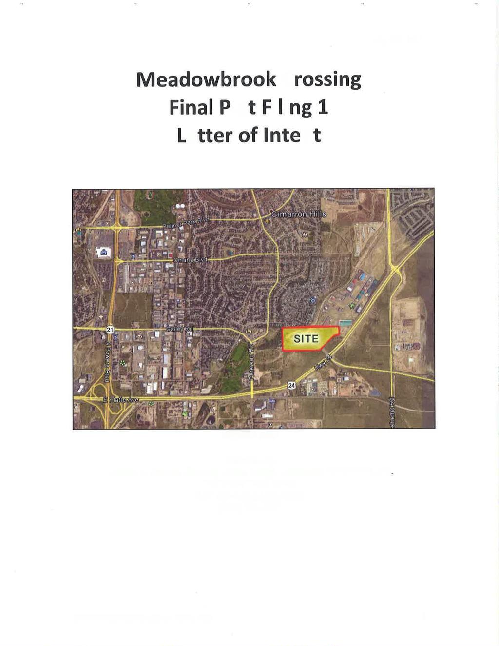
2 Road in Section 8, Township 14 South, Range 65 West of the 6th Principal Meridian. The parcel is not within the boundaries of a small area plan. A small portion of the parcel is within the APZ-2 (Accident Potential Zone 2) Subzone of the CAD-O (Commercial Airport Overlay District). Single-family residential is an allowed use within the APZ-2 Subzone. The Colorado Springs Airport Advisory Commission did not have concerns with the proposed final plat. The applicant has established an avigation easement on the property at the request of the Colorado Springs Airport Advisory Board. The applicant is providing a 15 foot buffer between the proposed single-family lots along the northern and eastern boundaries adjacent to non-residential zoning districts, pursuant to the requirements of Section D of the Land Development Code (2016). Water and wastewater service will be provided by Cherokee Metropolitan District. A. REQUEST/WAIVERS/AUTHORIZATION Request: A request by Meadowbrook Parkway, LLC, for approval of a final plat to create 79 single-family residential lots and 12 tracts to be used for open space, recreation, landscape, detention, drainage, utilities, future single-family residential, and a mail kiosk. Waiver(s): No waivers are requested with this final plat. Authorization to Sign: Final Plat, Subdivision Improvements Agreement, Detention Pond Maintenance Agreement and any other documents necessary to carry out the intent of the Board of County Commissioners. B. PLANNING COMMISSION SUMMARY Request Heard: Recommendation: Waiver Recommendation: Vote: Vote Rationale: Summary of Hearing: Legal Notice: C. APPROVAL CRITERIA In approving a final plat, the BoCC shall find that: The subdivision is in conformance with the goals, objectives, and policies of the Master Plan; 2
3 The subdivision is in substantial conformance with the approved preliminary plan; The subdivision is consistent with the subdivision design standards and regulations and meets all planning, engineering, and surveying requirements of the County for maps, data, surveys, analyses, studies, reports, plans, designs, documents, and other supporting materials; A sufficient water supply has been acquired in terms of quantity, quality, and dependability for the type of subdivision proposed, as determined in accordance with the standards set forth in the water supply standards [C.R.S (6)(a)] and the requirements of Chapter 8 of this Code; A public sewage disposal system has been established and, if other methods of sewage disposal are proposed, the system complies with State and local laws and regulations, [C.R.S (6)(b)] and the requirements of Chapter 8 of this Code; All areas of the proposed subdivision which may involve soil or topographical conditions presenting hazards or requiring special precautions have been identified and that the proposed subdivision is compatible with such conditions [C.R.S (6)(c)]; Adequate drainage improvements are proposed that comply with State Statute [C.R.S (3)(c)(VIII)] and the requirements of this Code and the ECM; Legal and physical access is provided to all parcels by public rights-of-way or recorded easement, acceptable to the County in compliance with this Code and the ECM; Necessary services, including police and fire protection, recreation, utilities, and transportation systems, are or will be made available to serve the proposed subdivision; The final plans provide evidence to show that the proposed methods for fire protection comply with Chapter 6 of this Code; Off-site impacts were evaluated and related off-site improvements are roughly proportional and will mitigate the impacts of the subdivision in accordance with applicable requirements of Chapter 8; Adequate public facilities or infrastructure, or cash-in-lieu, for impacts reasonably related to the proposed subdivision have been constructed or are financially guaranteed through the SIA so the impacts of the subdivision will be adequately mitigated; The subdivision meets other applicable sections of Chapter 6 and 8; and The extraction of any known commercial mining deposit shall not be impeded by this subdivision [C.R.S (1), et seq.] 3
4 D. LOCATION North: CS (Commercial Service)/ MHP (Mobile Home Park) Commercial/Residential South: CR (Commercial Regional) Vacant East: CR (Commercial Regional) Approved Commercial West: CR (Commercial Regional)/ M (Obsolete) Vacant E. BACKGROUND The property was zoned on May 11, 1942, and was rezoned to PID (Planned Industrial) and PBC (Planned Business Center) on August 8, Nomenclature changes have renamed the PID zoning district as the I-2 (Limited Industrial) zoning district and the PBC zoning district as the CR (Commercial Regional) zoning district. The property was rezoned to RS-5000 (Residential Suburban) on January 10, The property is located in the CAD-O (Commercial Airport Overlay District). The entire property is located in the ANAV (Aircraft Navigation) sub-zone and the northeast corner of the property is within the APZ-2 (Accident Potential Zone 2) Subzone. Single-family residential is an allowed use within the APZ-2 Sub-zone. The applicant submitted a noise study with this request for review and comment by the Colorado Springs Airport Advisory Commission (CSAAC). At the time of rezoning from a non-residential zoning district to the RS-5000 zoning district, the CSAAC determined that this property is outside of the 65 (DNL) Day-Night Average Sound Level noise contour; therefore, noise mitigation will not be required in order to develop single-family dwellings. The applicant has established an avigation easement on the property at the request of the Colorado Springs Airport Advisory Commission. The applicant is proposing a 15 foot buffer along the northern and eastern property lines, which will consist of a six (6) foot concrete cast wall and landscaping to be installed by the developer, and to be owned and maintained by the Meadowbrook Metropolitan District. A finding of water sufficiency is requested with the concurrently reviewed preliminary plan. F. ANALYSIS 1. Land Development Code Compliance This application meets the final plat submittal requirements, the General Development Standards in Chapter 6, the standards for Divisions of Land in Chapter 7, and the standards for Subdivision in Chapter 8 of the El Paso County 4
5 Land Development Code (2016). The final plat is in conformance with the concurrent preliminary plan request. 2. Zoning Compliance The area within the proposed final plat is zoned RS-5000 (Residential Suburban) zoning district. The density and dimensional standards of the RS-5000 zoning district, as established in Section 5.4.2, Table 5-4 of the Code, are listed below: Minimum lot size 5,000 square feet Setbacks 25 feet from front and rear lot lines, and 5 feet from side lot lines Maximum building height 30 feet Maximum lot coverage 45 percent for single-story and 40 percent for two-story 3. Policy Plan Analysis The El Paso County Policy Plan (1998) establishes broad policies and goals which are intended to serve as a framework for decision-making regarding development within the County. The following are policies from the Policy Plan as they specifically relate to this request. Policy Allow for a balance of mutually supporting interdependent land uses, including employment, housing, and services in the more urban and urbanizing areas of the County. Policy Encourage new development which is contiguous and compatible with previously developed areas in terms of factors such as density, land use, and access. Policy Commercial, office, industrial, and residential development should be compatible with surrounding land uses in terms of scale, intensity and potential impacts. The requested final plat is proposed to accommodate single-family residential development. The site is contiguous to existing urban level single-family residential use to the northwest and mobile-home residential to the north. The residential development will provide a buffer from the existing commercial properties to the north and east as required in Section D of the Land Development Code. The buffer is identified on the final plat. The final plat is compatible with existing uses in the area. For these reasons, staff recommends that a finding could be made for general conformance with the Policy Plan. 4. Small Area Plan Analysis The subject parcel is not within the boundaries of a small area plan. 5
6 5. Other Master Plan Elements The Master Plan for Mineral Extraction (1996) identifies potential stream terrace deposits comprised of sand, gravel, silt and clay in the area of the subject property. The mineral rights certification prepared by the applicant and the title policy indicate that there are severed mineral rights associated with the property. Notice has been mailed to the mineral rights holder regarding this final plat request. G. PHYSICAL SITE CHARACTERISTICS 1. Hazards A geology and soils report, dated December 9, 2016, was submitted by CTL Thompson in support of the concurrent preliminary plan and this final plat application. The report provides a geologic hazards evaluation and preliminary geotechnical investigation of the plan area. The report identified shallow groundwater, hydro-compactive soils, and erosion in areas. The report concludes that mitigation measures identified in the report can be completed so as to not preclude development. Colorado Geological Survey (CGS) reviewed the report and recommended the following: Basements should not be considered feasible on, at a minimum, proposed lots 25 through 31 and 46 through 52 unless site grades are raised sufficiently to provide a minimum 3 ft. separation distance between lowermost floor levels and shallowest anticipated seasonal groundwater levels. CGS also recommended the geotechnical engineer verify that the 30 ft. setback/sanitary sewer easement shown on the concurrent preliminary plan behind proposed lots 24 through 33 is adequate. The recommendation by CGS has been acknowledged by the applicant and has been incorporated into the final plat application by placing the impacted lots in future development tracts to be platted when the Letter of Map Revision (LOMR) has been completed. The applicant has identified the areas that will need to be mitigated on sheet 1 of the final plat, in the notes section. 6
7 2. Wildlife Potential impact to wildlife is generally low as depicted in the El Paso County Wildlife Habitat Descriptors Map (1996). 3. Floodplain Federal Emergency Management Agency (FEMA) Flood Insurance Rate Map (FIRM) 08041C0752-F shows that the 100-year floodplain (Zone AE) of East Fork Sand Creek impacts the northern portion of the property. On May 12, 2017, the applicant obtained an approved Conditional Letter of Map Revision (CLOMR), case number R, for the proposed modification of the existing floodplain. The CLOMR does not result in a change to the FIRM but indicates that if channel improvements are built as proposed, then the proposed modification of the existing floodplain would be recognized by FEMA. Once the channel improvements have been completed, the applicant must process an application with FEMA to obtain a Letter of Map Revision (LOMR) which will formalize the change to the floodplain. Building permits cannot be issued for areas within the current floodplain. Therefore, the applicant has shown these areas as a tract anticipated to be platted with Filing 2, after the approval of the Letter of Map Revision (LOMR). The LOMR is required prior to recording Filing Drainage and Erosion The proposed project is located in the Sand Creek (FOFO4000) drainage basin which was studied in East Fork Sand Creek flows through the property. The Sand Creek Drainage Basin Planning Study (DBPS) identified channel improvements within the property consisting of two drop structures and riprap lining along the channel banks. These channel improvements shall be constructed as depicted in the preliminary/final drainage report and construction drawings associated with the final plat. The channel improvements will be located within a tract in Meadowbrook Crossing Filing No. 1. Once the improvements are completed by the developer and the warranty period has passed, the County will accept a deed for ownership and maintenance of the tract. The Drainage Criteria Manual (DCM) includes a provision which allows developers to construct drainage improvements which are creditable toward drainage basin fees. It is anticipated that no payment of the drainage fee will be due upon the plat recordation since the DBPS cost estimate ($320,976.00) for the reimbursable drainage improvements anticipated to be constructed by the 7
8 applicant is in excess of the drainage fee due ($154,143.00). $46, in bridge fee is due with the plat recordation. The cost estimate for these channel improvements are in excess of the DBPS cost estimate. Therefore, the developer may avail themselves of the procedures outline in Chapter 3, Section 3.3 of the DCM to determine the final reimbursement. The site generally drains to the west. A portion of the stormwater runoff will be collected by a storm sewer system and will be directed to an extended detention basin which provides water quality detention. The pond then discharges westerly to East Fork Sand Creek. The extended detention basin will be a private facility, which shall be maintained by the Meadowbrook Metropolitan District. A grading and erosion control plan has been submitted with this application. The plan calls for construction and permanent best management practices (BMPs) to prevent sediment and debris from affecting adjoining properties and the public stormwater system before, during, and after grading activities. 5. Transportation The site is located north of the intersection of Highway 24 and Meadowbrook Parkway, west of Claremont Business Park and south of the East Fork of Sand Creek. The proposed residential development will provide two access points along Meadowbrook Parkway. The plat dedicates additional right-of-way to El Paso County along the southern boundary of the property which will be used to connect the future extension of Meadowbrook Parkway to Peterson Road. All interior roadways are planned to be constructed to El Paso County criteria. The developer constructed roadways total 0.76 lane miles, which will be dedicated to the County for ownership and maintenance. Meadowbrook Crossing Filing No. 1 is subject to the countywide Road Impact Fee Program (Resolution ). The applicant has elected to include this subdivision within the El Paso County Public Improvements District No. 2 and as such will be subject to applicable road impact fees and mill levy. 8
9 H. SERVICES 1. Water Sufficiency: Cherokee Metropolitan District has committed to providing service. Quality: Sufficient Quantity: Sufficient Dependability: Sufficient Attorney s summary: The County Attorney s Office has provided a recommendation regarding a finding of sufficiency for water quantity and dependability with the concurrently reviewed preliminary plan. El Paso County Public Health also made a recommendation for a finding of sufficiency in terms of water quality with the concurrently reviewed preliminary plan. The State Engineer Office has provided an opinion that water supply can be provided without causing injury at the preliminary plan stage. 2. Sanitation Cherokee Metropolitan District has committed to providing wastewater service to the development. 3. Emergency Services The site is within the boundaries of the Cimarron Hills Fire Protection District. The District was sent a copy of the final plat request. The District has no objections to this request. 4. Utilities The subject property is within the Colorado Springs Utilities (CSU) service area for natural gas and electrical service. CSU had no objections to the request. Standard utility easements are shown on the final plat. 5. Metropolitan Districts The property is within the boundaries of Cherokee Metropolitan District and within the boundaries of Meadowbrook Metropolitan District. The Board of County Commissioners approved the Meadowbrook Metropolitan District on October 4, The District election was held and approved by the electorate on November 8, District Court issued the decree creating the District on November 15, The current debt service mill levy is 35 mills. The applicant has informed staffs that it plans to request an amendment to the service plan to increase the maximum mill levy to 50 mills for debt service due to the expenses related to the 9
10 channel improvements outlined in the CLOMR. The Meadowbrook Metropolitan District will maintain the private detention facility depicted on the plat. The applicant is proposing to be included into the Public Improvement District No. 2 to satisfy the Road Impact Fee program requirements. 6. Parks/Trails The El Paso County Parks Master Plan (2013) shows no open space, park facilities, or trails intersected by or within the project area. Payment of Regional (Area 2) Park fees in the amount of $32, and Urban (Area 3) Park fees in the amount of $20, in lieu of land dedication will be due at the time of the final plat recordation. 7. Schools The property is located within Colorado Springs School District No. 11. The District was sent a copy of this request and did not have concerns regarding the development. Payment of school fees in the amount of $14, in lieu of land dedication will be due at the time of final plat recordation. I. APPLICABLE RESOLUTIONS Approval Page 19 Disapproval Page 20 J. STATUS OF MAJOR ISSUES There are no major issues with this request. K. CONDITIONS AND NOTATIONS Should the Planning Commission and Board of County Commissioners find that the request meets the criteria for approval outlined in Section (Subdivisions) of the El Paso County Land Development Code (2016) staff recommends the following conditions and notation: CONDITIONS 1. All Deed of Trust holders shall ratify the plat. The applicant shall provide a current title commitment at the time of submittal of the Mylar for recording. 2. Colorado statute requires that at the time of the approval of platting, the subdivider provides the certification of the County Treasurer s Office that all ad valorem taxes applicable to such subdivided land, or years prior to that year in which approval is granted, have been paid. Therefore, this plat is approved by the Board of County 10
11 Commissioners on the condition that the subdivider or developer must provide to the Planning and Community Development Department, at the time of recording the plat, a certification from the County Treasurer s Office that all prior years taxes have been paid in full. 3. The subdivider or developer must pay, for each parcel of property, the fee for tax certification in effect at the time of recording the plat. 4. The Applicant shall submit the Mylar to Enumerations for addressing. 5. Developer shall comply with federal and state laws, regulations, ordinances, review and permit requirements, and other agency requirements, if any, of applicable agencies including, but not limited to, the Colorado Division of Wildlife, Colorado Department of Transportation, U.S. Army Corps of Engineers and the U.S. Fish and Wildlife Service regarding the Endangered Species Act, particularly as it relates to the Preble's Meadow Jumping Mouse as a listed species. 6. Driveway permits will be required for each access to an El Paso County owned and maintained roadway. Driveway permits are obtained from the El Paso County Planning and Community Development Department. 7. The Subdivision Improvements Agreement, including the financial assurance estimate, as approved by the El Paso County Planning and Community Development Department, shall be filed at the time of recording the final plat. 8. Collateral sufficient to ensure that the public improvements as listed in the approved financial assurance estimate shall be provided when the final plat is recorded. 9. The Subdivider(s) agrees on behalf of him/herself and any developer or builder successors and assignees that Subdivider and/or said successors and assigns shall be required to pay traffic impact fees in accordance with the El Paso County Road Impact Fee Program Resolution (Resolution No ), or any amendments thereto, at or prior to the time of building permit submittals. The fee obligation, if not paid at final plat recording, shall be documented on all sales documents and on plat notes to ensure that a title search would find the fee obligation before sale of the property. 10. Park fees in lieu of land dedication for regional parks (Area 2) and urban park (Area 3) fees shall be paid at the time of plat recordation. 11
12 11. School fees in lieu of school land dedication shall be paid to El Paso County for the benefit of Colorado Springs School District No. 11 at the time of plat recordation. 12. Drainage fees in the amount of $154, for the Sand Creek (FOFO4000) drainage basin shall be paid to El Paso County at the time of final plat recordation unless the regional Sand Creek channel improvements identified in the DBPS are constructed and preliminarily accepted prior to plat recordation. 13. Bridge fees in the amount of $46, for the Sand Creek (FOFO4000) drainage basin shall be paid to El Paso County at the time of final plat recordation. 14. The developer shall provide financial assurance and will be responsible for the construction of the channel improvements depicted in the preliminary/final drainage report and construction drawings associated with the final plat upon plat recordation if the regional channel improvements are not completed and preliminarily accepted prior to the plat recordation. 15. The Board authorized the Planning and Community Director to administratively accept dedication of right-of-way to the County on Lots 1 and 79 in this filing, if future traffic studies identify the need for acquisition of said land to accommodate the design and construction of improvements at the intersection of Meadowbrook Parkway and Meadowbrook Parkway. (A road name change is under review). The Director is also hereby authorized to administratively approve an amendment to this plat depicting any necessary changes to Lots 1 and 79 in order to facilitate the dedication of such right-of-way. The Board also authorizes the Director to administratively approve a reduction in building setbacks and an increase in the allowed lot coverage for Lots 1 and 79 to allowed Lots 1 and 79 to be developed with single family residential dwellings if dedication of the additional land for the intersection improvements is provided. NOTATIONS 1. Final plats not recorded within 24 months of Board of County Commissioner approval shall be deemed expired, unless an extension is approved. 2. The applicant is proposing to be included into the Public Improvement District No. 2 to satisfy the Road Impact Fee program requirements. L. PUBLIC COMMENT AND NOTICE The Planning and Community Development Department notified nine (9) adjoining property owners on August 21, 2017, for the Planning Commission meeting. Responses will be provided at the hearing. 12
13 M. ATTACHMENTS Vicinity Map Letter of Intent Plat Drawing 13
14 14
15 15
16 16
17 17
18 18
19 19
20 20
21 21
22 22
23 23
24 24
25 25

26 26
Project File #: SF Project Name: Jackson Ranch Filing No. 4 Parcel Nos.: , and
 COMMISSIONERS: DARRYL GLENN (PRESIDENT) MARK WALLER (PRESIDENT PRO TEMPORE) STAN VANDERWERF LONGINOS GONZALEZ PEGGY LITTLETON PLANNING AND COMMUNITY DEVELOPMENT DEPARTMENT CRAIG DOSSEY, EXECUTIVE DIRECTOR
Project File #: VA Project Name: Beauperthuy Variance Parcel Nos.: , , , ,
 COMMISSIONERS: DARRYL GLENN (PRESIDENT) MARK WALLER (PRESIDENT PRO TEMPORE) STAN VANDERWERF LONGINOS GONZALEZ PEGGY LITTLETON PLANNING AND COMMUNITY DEVELOPMENT DEPARTMENT CRAIG DOSSEY, EXECUTIVE DIRECTOR
Planning Commission Hearing Date: 2/21/2017 Board of County Commissioners Hearing Date: 3/8/2017
 COMMISSIONERS: DARRYL GLENN (PRESIDENT) MARK WALLER (PRESIDENT PRO TEMPORE) STAN VANDERWERF LONGINOS GONZALEZ PEGGY LITTLETON PLANNING AND COMMUNITY DEVELOPMENT DEPARTMENT CRAIG DOSSEY, EXECUTIVE DIRECTOR
Project File #: SP Project Name: Springs at Waterview Preliminary Plan Parcel No.:
 COMMISSIONERS: DARRYL GLENN (PRESIDENT) MARK WALLER (PRESIDENT PRO TEMPORE) STAN VANDERWERF LONGINOS GONZALEZ PEGGY LITTLETON PLANNING AND COMMUNITY DEVELOPMENT DEPARTMENT CRAIG DOSSEY, EXECUTIVE DIRECTOR
REPRESENTATIVE: NES, Inc. 619 North Cascade Avenue, Suite 200 Colorado Springs, CO 80903
 COMMISSIONERS: MARK WALLER (CHAIR) LONGINOS GONZALEZ, JR. (VICE-CHAIR) HOLLY WILLIAMS STAN VANDERWERF CAMI BREMER PLANNING AND COMMUNITY DEVELOPMENT DEPARTMENT CRAIG DOSSEY, EXECUTIVE DIRECTOR TO: FROM:
REPRESENTATIVE: Centerline Solutions Table Mountain Parkway Golden, CO 80403
 COMMISSIONERS: DARRYL GLENN (PRESIDENT) MARK WALLER (PRESIDENT PRO TEMPORE) STAN VANDERWERF LONGINOS GONZALEZ PEGGY LITTLETON PLANNING AND COMMUNITY DEVELOPMENT DEPARTMENT CRAIG DOSSEY, EXECUTIVE DIRECTOR
Planning Commission Hearing Date: 1/2/2018 Board of County Commissioners Hearing Date 1/23/2018
 COMMISSIONERS: DARRYL GLENN (PRESIDENT) MARK WALLER (PRESIDENT PRO TEMPORE) STAN VANDERWERF LONGINOS GONZALEZ PEGGY LITTLETON PLANNING AND COMMUNITY DEVELOPMENT DEPARTMENT CRAIG DOSSEY, EXECUTIVE DIRECTOR
Planning Commission Hearing Date: 3/6/2018 Board of County Commissioners Hearing Date 3/27/2018
 COMMISSIONERS: DARRYL GLENN (PRESIDENT) MARK WALLER (PRESIDENT PRO TEMPORE) STAN VANDERWERF LONGINOS GONZALEZ PEGGY LITTLETON PLANNING AND COMMUNITY DEVELOPMENT DEPARTMENT CRAIG DOSSEY, EXECUTIVE DIRECTOR
REPRESENTATIVE: Julie & Brad Nicodemus Black Squirrel Road Colorado Springs, CO 80809
 COMMISSIONERS: DARRYL GLENN (PRESIDENT) MARK WALLER (PRESIDENT PRO TEMPORE) STAN VANDERWERF LONGINOS GONZALEZ PEGGY LITTLETON PLANNING AND COMMUNITY DEVELOPMENT DEPARTMENT CRAIG DOSSEY, EXECUTIVE DIRECTOR
Planning Commission Hearing Date: 5/2/2017 Board of County Commissioners Hearing Date 5/23/2017
 COMMISSIONERS: DARRYL GLENN (PRESIDENT) MARK WALLER (PRESIDENT PRO TEMPORE) STAN VANDERWERF LONGINOS GONZALEZ PEGGY LITTLETON PLANNING AND COMMUNITY DEVELOPMENT DEPARTMENT CRAIG DOSSEY, EXECUTIVE DIRECTOR
Project File #: SF Project Name: Redtail Ranch Subdivision Parcel Nos.: , , ,
 COMMISSIONERS: MARK WALLER (CHAIR) LONGINOS GONZALEZ, JR. (VICE-CHAIR) HOLLY WILLIAMS STAN VANDERWERF CAMI BREMER PLANNING AND COMMUNITY DEVELOPMENT DEPARTMENT CRAIG DOSSEY, EXECUTIVE DIRECTOR TO: FROM:
Nina Ruiz, Project Manager/Planner II Gilbert LaForce, Engineer II Craig Dossey, Executive Director Planning & Community Development
 COMMISSIONERS: DARRYL GLENN (PRESIDENT) MARK WALLER (PRESIDENT PRO TEMPORE) STAN VANDERWERF LONGINOS GONZALEZ PEGGY LITTLETON PLANNING AND COMMUNITY DEVELOPMENT DEPARTMENT CRAIG DOSSEY, EXECUTIVE DIRECTOR
Letter of Intent May 2017 (Revised November 2017)
") THE BEACH AT WOODMOOR LETTER OF INTENT MAY 2017 (REVISED NOVEMBER 2017) OWNER/APPLICANT: CONSULTANT: Lake Woodmoor Holdings LLC N.E.S. Inc. 1755 Telstar Drive, Suite 211 619 North Cascade Avenue Colorado
THE BEACH AT WOODMOOR LETTER OF INTENT MAY 2017 (REVISED NOVEMBER 2017) OWNER/APPLICANT: CONSULTANT: Lake Woodmoor Holdings LLC N.E.S. Inc. 1755 Telstar Drive, Suite 211 619 North Cascade Avenue Colorado
Guide to Combined Preliminary and Final Plats
 Guide to Combined Preliminary and Final Plats Introduction The Douglas County is committed to providing open, transparent application processes to the public. This Guide is provided to assist anyone interested
Gabe Sevigney, Project Manager/Planner I Gilbert LaForce, Engineer II Craig Dossey, Executive Director Planning & Community Development
 COMMISSIONERS: DARRYL GLENN (PRESIDENT) MARK WALLER (PRESIDENT PRO TEMPORE) STAN VANDERWERF LONGINOS GONZALEZ PEGGY LITTLETON PLANNING AND COMMUNITY DEVELOPMENT DEPARTMENT CRAIG DOSSEY, EXECUTIVE DIRECTOR
Nina Ruiz, PM/Planner II Mike Hrebenar, Project Management Group Manager Elizabeth Nijkamp, PE Engineering Manager Craig Dossey, Executive Director
 COMMISSIONERS: DARRYL GLENN (PRESIDENT) MARK WALLER (PRESIDENT PRO TEMPORE) STAN VANDERWERF LONGINOS GONZALEZ PEGGY LITTLETON PLANNING AND COMMUNITY DEVELOPMENT DEPARTMENT CRAIG DOSSEY, EXECUTIVE DIRECTOR
MS MINOR SUBDIVISION TREVITHICK
 MS-02-015 341.12 MINOR SUBDIVISION TREVITHICK A request by Danny Trevithick for a one-lot Minor Subdivision on five acres. The property is zoned A-35 (Agricultural) District and is located ¼ mile south
Guide to Minor Developments
 Guide to Minor Developments Introduction The Douglas County (DCD) is committed to providing open, transparent application processes to the public. This Guide is provided to assist anyone interested in
Project File #: P Project Name: Springs at Waterview Residential Rezone Parcel No.:
 COMMISSIONERS: DARRYL GLENN (PRESIDENT) MARK WALLER (PRESIDENT PRO TEMPORE) STAN VANDERWERF LONGINOS GONZALEZ PEGGY LITTLETON PLANNING AND COMMUNITY DEVELOPMENT DEPARTMENT CRAIG DOSSEY, EXECUTIVE DIRECTOR
Project File #: VR Project Name: Claremont Ranch Filing 9C Vacate Replat Parcel No.:
 COMMISSIONERS: DARRYL GLENN (PRESIDENT) MARK WALLER (PRESIDENT PRO TEMPORE) STAN VANDERWERF LONGINOS GONZALEZ PEGGY LITTLETON PLANNING AND COMMUNITY DEVELOPMENT DEPARTMENT CRAIG DOSSEY, EXECUTIVE DIRECTOR
Guide to Preliminary Plans
 Guide to Preliminary Plans Introduction The Douglas County is committed to providing open, transparent application processes to the public. This Guide is provided to assist anyone interested in the procedures
these areas are compatible with such conditions. [Section (6) (c) C. R. S.]
![these areas are compatible with such conditions. [Section (6) (c) C. R. S.]](/thumbs/83/88180230.jpg "these areas are compatible with such conditions. [Section (6) (c) C. R. S.]") SECTION 14-200 PRELIMINARY PLAT 14-201 INTENT A Preliminary Plat is one of the first documents utilized when owners of a property wish to subdivide their property in accordance with State Statutes and
SECTION 14-200 PRELIMINARY PLAT 14-201 INTENT A Preliminary Plat is one of the first documents utilized when owners of a property wish to subdivide their property in accordance with State Statutes and
REPRESENTATIVE: Kesti Suggs Holmes Rd Colorado Springs, CO 80908
 COMMISSIONERS: DARRYL GLENN (PRESIDENT) MARK WALLER (PRESIDENT PRO TEMPORE) STAN VANDERWERF LONGINOS GONZALEZ PEGGY LITTLETON PLANNING AND COMMUNITY DEVELOPMENT DEPARTMENT CRAIG DOSSEY, EXECUTIVE DIRECTOR
Guide to Replats. Step 1. Step 2. Step 3. Step 4. Step 5. Step 6. Step 7. Step 8. Step 9. Step 10
 Guide to Replats Introduction Douglas County is committed to providing open, transparent application processes to the public. This Guide is provided to assist anyone interested in the procedures and expectations
MAJOR BOUNDARY LINE ADJUSTMENT PROCESS GUIDE
 MAJOR BOUNDARY LINE ADJUSTMENT PROCESS GUIDE Clear Creek County Planning Department P.O. Box 2000 Georgetown, Colorado 80444 (303) 679-2436 - phone (303) 569-1103 - fax PURPOSE To establish criteria and
MINOR BOUNDARY LINE ADJUSTMENT PROCESS GUIDE
 MINOR BOUNDARY LINE ADJUSTMENT PROCESS GUIDE Clear Creek County Planning Department P.O. Box 2000 Georgetown, Colorado 80444 (303) 679-2436 phone (303) 569-1103 fax 1 PURPOSE To establish criteria and
SUBDIVISION APPLICATION (CHECK THE BOX THAT APPLIES)
") GARFIELD COUNTY Building & Planning Department 108 8 th Street, Suite 401 Glenwood Springs, Colorado 81601 Telephone: 970.945.8212 Facsimile: 970.384.3470 www.garfield-county.com SUBDIVISION APPLICATION
GARFIELD COUNTY Building & Planning Department 108 8 th Street, Suite 401 Glenwood Springs, Colorado 81601 Telephone: 970.945.8212 Facsimile: 970.384.3470 www.garfield-county.com SUBDIVISION APPLICATION
DOUGLAS COUNTY SUBDIVISION RESOLUTION Article 4 Preliminary Plan 10/13/2015
 ARTICLE 4 PRELIMINARY PLAN 401 Intent An in-depth analysis of the proposed subdivision, including a review of the design considering the ability to obtain water and sanitation, identified geologic hazards,
Town of Lisbon, Maine SUBDIVISION REVIEW APPLICATION
 Date Received: Fee Paid (amount): Applicant: Town of Lisbon, Maine SUBDIVISION REVIEW APPLICATION Subdivision Name/Title: This application must be received at the Town Office by close of business on the
SUBDIVISION REGULATIONS
 CHAPTER 14 SUBDIVISION REGULATIONS 14-100 Provisions 14-200 Preliminary Plat 14-300 Final Plat 14-400 Replat 14-500 Minor Subdivision 14-600 Administrative Replat 14-700 Vacation of Roadways, Public Easements,
Town of Shelburne, Vermont
 Town of Shelburne, Vermont CHARTERED 1763 P.O. BOX 88 5420 SHELBURNE ROAD SHELBURNE, VT 05482 www.shelburnevt.org 802-985-5118 * * Also available in alternate formats in accordance with the Americans With
Board Summary Report
 Board of County Commissioners: Public Hearing Agenda, August 7, 2018 Agenda Item: # Date: July 25, 2018 To: Through: From: Subject: Board of County Commissioners Jan Yeckes, Planning Division Manager Bill
To provide for the review of the final engineering plans, the subdivision improvement agreement, public dedications, and other legal agreements.
 ARTICLE 5 FINAL PLAT 501 Intent DOUGLAS COUNTY SUBDIVISION RESOLUTION To provide for the review of the final engineering plans, the subdivision improvement agreement, public dedications, and other legal
Chapter 5. Floodplain Management. 5.0 Introduction. 5.1 Douglas County Comprehensive Master Plan. 5.2 Floodplain Management and Regulation
 5.0 Introduction This chapter summarizes the County s rules and regulations regarding floodplain management and development. The requirements presented in this chapter should be used by the design engineer
TRANSFERABLE DEVELOPMENT RIGHTS PROCESS GUIDE
 TRANSFERABLE DEVELOPMENT RIGHTS PROCESS GUIDE Clear Creek County Planning Department P.O. Box 2000 Georgetown, Colorado 80444 (303) 679-2436 - phone (303) 569-1103 - fax 1 PURPOSE: A Transfer of Development
SUBDIVISION APPLICATION CHECKLIST SKETCH PLAN PRELIMINARY PLAT FINAL PLAT
 RECEIVED STAMP SUBDIVISION APPLICATION CHECKLIST SKETCH PLAN PRELIMINARY PLAT FINAL PLAT A checklist of background information and submission requirements for processing of a sketch plan, preliminary plat
Chapter 5. Floodplain Management. 5.0 Introduction. 5.1 Floodplain Management and Regulation
 5.0 Introduction This chapter summarizes the Town s rules and regulations regarding floodplain management and development. The requirements presented in this chapter should be used by the design engineer
Tentative Map Application Review Procedures
 FOR REFERENCE ONLY This page is not part of the application. Tentative Map Application Review Procedures The tentative map process in Churchill County is designed to provide a mechanism in order to divide
FINAL PLAT SUBMITTAL CHECKLIST
 FINAL PLAT SUBMITTAL CHECKLIST The submission requirements for a Final Plat Review are found beginning in Section 24-4-40 of the Weld County Code. The Weld County Code is available on line at www.co.weld.co.us
SUBJECT PARCEL(S) Property Owner(s) TMS Number Approximate Acreage Carolina Park Development, LLC
 Property Owner(s) TMS Number Approximate Acreage Carolina Park Development, LLC") Staff Report Special Planning Commission Meeting November 19, 2014 For reference, the Zoning Code and Land Development Regulations are available online. AGENDA ITEM 5c. SKETCH PLAN APPROVAL REQUEST: Request
Staff Report Special Planning Commission Meeting November 19, 2014 For reference, the Zoning Code and Land Development Regulations are available online. AGENDA ITEM 5c. SKETCH PLAN APPROVAL REQUEST: Request
SECTION 4: PRELIMINARY PLAT
 SECTION 4: PRELIMINARY PLAT After the completion of the sketch plan process, if submitted, the owner or developer shall file with the City an application for preliminary plat. The preliminary plat stage
WASCO COUNTY PRELIMINARY SUBDIVISION APPLICATION
 WASCO COUNTY PRELIMINARY SUBDIVISION APPLICATION DETAILED SPECIFIC WRITTEN REQUEST File Number: SDV- Number of Proposed Lots & their Dimensions: PRELIMINARY SUBDIVISION PLAN REQUIREMENTS The approval of
Township of Collier 2418 Hilltop Road Presto, PA 15142
 Township of Collier 2418 Hilltop Road Presto, PA 15142 Fees: Major: 2 checks $600 + $50 per lot & $1700 Escrow) APPLICATION FOR SUBDIVISION major FINAL only Plans must be folded Rolled plans will not be
DEPARTMENT OF PLANNING SERVICES 1555 N 17 th Ave Greeley CO Phone (970) Fax (970)
 Fax (970)") DEPARTMENT OF PLANNING SERVICES 1555 N 17 th Ave Greeley CO 80631 Phone (970) 400-6100 Fax (970) 304-6498 SITE SPECIFIC DEVELOPMENT PLAN USE BY SPECIAL REVIEW PROCEDURAL GUIDE SOLID WASTE DISPOSAL SITES
DEPARTMENT OF PLANNING SERVICES 1555 N 17 th Ave Greeley CO 80631 Phone (970) 400-6100 Fax (970) 304-6498 SITE SPECIFIC DEVELOPMENT PLAN USE BY SPECIAL REVIEW PROCEDURAL GUIDE SOLID WASTE DISPOSAL SITES
CASE # P DOVE VALLEY V, FILING #13 (REPLAT OF BLOCK 12, LOTS 1 16 AND TRACTS A, B, D) BILL SKINNER, SENIOR PLANNER JUNE 14, 2016
 BILL SKINNER, SENIOR PLANNER JUNE 14, 2016") ARAPAHOE COUNTY BOARD OF COUNTY COMMISSIONERS PUBLIC HEARING June 28, 2016 9:30 A.M. CASE # P15-010 DOVE VALLEY V, FILING #13 (REPLAT OF BLOCK 12, LOTS 1 16 AND TRACTS A, B, D) BILL SKINNER, SENIOR PLANNER
ARAPAHOE COUNTY BOARD OF COUNTY COMMISSIONERS PUBLIC HEARING June 28, 2016 9:30 A.M. CASE # P15-010 DOVE VALLEY V, FILING #13 (REPLAT OF BLOCK 12, LOTS 1 16 AND TRACTS A, B, D) BILL SKINNER, SENIOR PLANNER
REPORT TO THE SHELBY COUNTY PLANNING COMMISSION From the Department of Development Services Planning Services. February 4, 2019
 REPORT TO THE SHELBY COUNTY PLANNING COMMISSION From the Department of Development Services Planning Services February 4, 2019 Case No. Request for Rezoning Approval From E-1 to E-2 SD This is a request
El Paso County Development Review System Adopted Fee Schedule (2005)
") Special Districts Special District 5 (multiple districts for the same project is one fee) D $6,300 Special District Amendment 5 D $3,950 Master Plans Master Plan, Master Plan Amendment D $11,900 Land Use
Special Districts Special District 5 (multiple districts for the same project is one fee) D $6,300 Special District Amendment 5 D $3,950 Master Plans Master Plan, Master Plan Amendment D $11,900 Land Use
CITY OF CORNING TENTATIVE MAPS
 CITY OF CORNING TENTATIVE MAPS APPLICANT S GUIDE TO PROCEDURES WHAT IS A TENTATIVE MAP? A division of land for the purpose of sale, lease, or finance requires submittal of a map for City approval showing
River Rock Estates Sketch Plan, a proposed major subdivision in S24, T35N R2W NMPM on County Rd 119 (PLN18-336)
") MEMORANDUM Archuleta County Development Services Planning Department 1122 HWY 84 P. O. Box 1507 Pagosa Springs, Colorado 81147 970-264-1390 Fax 970-264-3338 TO: Archuleta County Planning Commission FROM:
MEMORANDUM Archuleta County Development Services Planning Department 1122 HWY 84 P. O. Box 1507 Pagosa Springs, Colorado 81147 970-264-1390 Fax 970-264-3338 TO: Archuleta County Planning Commission FROM:
PRESENT AND VOTING: JIM EGBERT, ALLAN CREELY, TONY GIOIA, KEVIN CURRY, JOAN LUCIA-TREESE, KEVIN MASTIN, AND JANE DILLON
 COMMISSIONERS: DARRYL GLENN (PRESIDENT) MARK WALLER (PRESIDENT PRO TEMPORE) STAN VANDERWERF LONGINOS GONZALEZ PEGGY LITTLETON PLANNING AND COMMUNITY DEVELOPMENT DEPARTMENT CRAIG DOSSEY, EXECUTIVE DIRECTOR
FREQUENTLY USED PLANNING & ZONING TERMS
 City Of Mustang FREQUENTLY USED PLANNING & ZONING TERMS Abut: Having property lines, street lines, or zoning district lines in common. Accessory Structure: A structure of secondary importance or function
STAFF REPORT FOR MAJOR SUBDIVISION
 STAFF REPORT FOR MAJOR SUBDIVISION FINAL PLAT CASE NO. FA-13-001 HEARING DATE: November 6, 2013 CASE NAME: Solterra Subdivision Filing No. 14 PROCEDURE: Planning Commission ADDRESS OF MAJOR SUBDIVISION
CITY OF FORT COLLINS NATURAL AREAS AND CONSERVED LANDS EASEMENT POLICY
 CITY OF FORT COLLINS NATURAL AREAS AND CONSERVED LANDS EASEMENT POLICY Adopted January 3, 2012 PURPOSE: The purpose of the policy statement is to clarify the policies and procedures of the City of Fort
City of Leavenworth DEPARTMENT OF DEVELOPMENT SERVICES MAJOR SUBDIVISION APPLICATION 1
 Proposed Name of Subdivision: City of Leavenworth DEPARTMENT OF DEVELOPMENT SERVICES MAJOR SUBDIVISION APPLICATION 1 FOR PRELIMINARY SUBDIVISION APPROVAL This application must be filled out legibly, in
MINERAL COUNTY PLANNING STAFF FINDINGS OF FACT Proposed Elk Run at St. Regis. February 12, 2017
 MINERAL COUNTY PLANNING STAFF FINDINGS OF FACT Proposed The proposed is a five-lot subdivision and is located approximately one mile east of St. Regis on Old Highway 10 East. The property is located in
SUBMITTAL REQUIREMENTS: The number indicates the number of copies for submittal (if applicable).
.") Office Use Only Preliminary Long Plat Long Subdivision Applicant Checklist PLANNING, COMMUNITY, & ECONOMIC DEVELOPMENT DEPARTMENT PRELIMINARY LONG PLAT LONG SUBDIVISION CHECKLIST Mailing Address: P.O.
Office Use Only Preliminary Long Plat Long Subdivision Applicant Checklist PLANNING, COMMUNITY, & ECONOMIC DEVELOPMENT DEPARTMENT PRELIMINARY LONG PLAT LONG SUBDIVISION CHECKLIST Mailing Address: P.O.
SECTION 10 STANDARD PLATS
 SECTION 10 - STANDARD PLATS Subdivision 1: Purpose Standard Plats allow the subdivision of land into lots smaller than the minimum metes and bounds size in the zoning district, and control road development
ARTICLE FIVE FINAL DRAFT
 ARTICLE FIVE 021218 FINAL DRAFT Sec. 503.6 Open Space Preservation Option Open Space Preservation Option Open Space Preservation developments may be approved in the AR, R-1, R-2 and R-3 zoning districts,
Legal Description Part of the Western Half of the Eastern Half of the Northwest Quarter of Section 30, Le Ray Township
 Owner and Applicant s 20448 State Highway 83 Mankato, MN 56001 Request and Location Request for review and approval of a Conditional Use Permit to allow an Elder Care Residential Unit to be constructed
SECTION 10: FLOOD HAZARD EVALUATION 10-1
 10) SECTION 10: FLOOD HAZARD EVALUATION A. General. Land subject to being flooded by a Flood of 100-Year Frequency as defined by Title 76, Chapter 5, MCA, or land subject to flooding pursuant to these
Chapter 100 Planned Unit Development in Corvallis Urban Fringe
 100.100 Scope and Purpose. Chapter 100 Planned Unit Development in Corvallis Urban Fringe (1) All applications for land divisions in the Urban Residential (UR) and Flood Plain Agriculture (FPA) zones within
Town of Cary, North Carolina Rezoning Staff Report 12-REZ-27 Morris Branch Town Council Public Hearing January 24, 2013
 Town of Cary, North Carolina Rezoning Staff Report 12-REZ-27 Morris Branch Town Council Public Hearing January 24, 2013 REQUEST To amend the Town of Cary Official Zoning Map to rezone approximately 9.0
Purpose: Regulations:
 Administrative Procedures for the Designation and Refinement Of Chesapeake Bay Preservation Area Boundaries Guidance on the Chesapeake Bay Preservation Area Designation and Management Regulations September,
SUBMITTAL REQUIREMENTS: The number indicates the number of copies for submittal (if applicable).
.") Office Use Only Preliminary Long Plat Long Subdivision Applicant Checklist PLANNING, COMMUNITY, & ECONOMIC DEVELOPMENT DEPARTMENT FINAL LONG PLAT LONG SUBDIVISION CHECKLIST Mailing Address: P.O. Box 547,
Office Use Only Preliminary Long Plat Long Subdivision Applicant Checklist PLANNING, COMMUNITY, & ECONOMIC DEVELOPMENT DEPARTMENT FINAL LONG PLAT LONG SUBDIVISION CHECKLIST Mailing Address: P.O. Box 547,
Subdivision (Plat) Checklist
 Checklist") Subdivision (Plat) Checklist This Checklist is intended to assist you in preparing a complete application for submittal. Occasionally, additional items may be required to complete the review. Incomplete
Subdivision (Plat) Checklist This Checklist is intended to assist you in preparing a complete application for submittal. Occasionally, additional items may be required to complete the review. Incomplete
MINOR SUBDIVISION INFORMATION
 A. POINTS OF CONTACT: MINOR SUBDIVISION INFORMATION Surveyor: Address: Phone #: Fax # E-Mail Address: Representative (If different from applicant): Address: Phone #: Fax # E-Mail Address: B. GENERAL INFORMATION:
DEVELOPMENT PLAN ORDINANCE
 DEVELOPMENT PLAN ORDINANCE CITY OF GLASGOW Ordinance No. 2026 SECTION A. Section 1. INTENT AND PURPOSE The purpose of this Ordinance is to establish and define development plans, which may be utilized
Article 6: Planned Unit Developments
 LUDC 2013 GARFIELD COUNTY, COLORADO Article 6: Planned Unit Developments ARTICLE 6 PLANNED UNIT DEVELOPMENTS TABLE OF CONTENTS DIVISION 1. GENERAL.... 1 6-101. GENERAL PROVISIONS.... 1 A. Purpose....
ARTICLE 14 PLANNED UNIT DEVELOPMENT (PUD) DISTRICT
 DISTRICT") ARTICLE 14 PLANNED UNIT DEVELOPMENT (PUD) DISTRICT Section 14.01 Intent. It is the intent of this Article to allow the use of the planned unit development (PUD) process, as authorized by the Michigan Zoning
ARTICLE 14 PLANNED UNIT DEVELOPMENT (PUD) DISTRICT Section 14.01 Intent. It is the intent of this Article to allow the use of the planned unit development (PUD) process, as authorized by the Michigan Zoning
CHECKLIST FOR DEVELOPMENT REVIEW
 CHECKLIST FOR DEVELOPMENT REVIEW Petitions and related documents and plans for land development or other proposals regulated by Title 16 of the Municipal Code (Development Ordinance) and Title 17 of the
APPLICATION FOR 555 Washington Street Tentative Map Red Bluff, CA Subdivision Map (530) ext Parcel Map.
 ext Parcel Map.") City of Red Bluff Community Development Department Application No. APPLICATION FOR 555 Washington Street Tentative Map Red Bluff, CA 96080 Subdivision Map (530) 527-2605 ext. 3059 Parcel Map Applicant
City of Red Bluff Community Development Department Application No. APPLICATION FOR 555 Washington Street Tentative Map Red Bluff, CA 96080 Subdivision Map (530) 527-2605 ext. 3059 Parcel Map Applicant
PLANNING COMMISSION REPORT Regular Agenda Non Public Hearing Item
 PC Staff Report 3/23/15 FDP-14-00551 Item No. 2-1 PLANNING COMMISSION REPORT Regular Agenda Non Public Hearing Item PC Staff Report 3/23/15 ITEM NO. 2: FINAL DEVELOPMENT PLAN FOR HUTTON FARMS WEST PHASE
ARTICLE 6 MINOR DEVELOPMENT FINAL PLAT Single-Family Residential
 ARTICLE 6 MINOR DEVELOPMENT FINAL PLAT Single-Family Residential 601 Intent The intent of the minor development is to provide a streamlined review process for the creation of ten or fewer single-family
MINOR SUBDIVISION FINAL PLAT APPLICATION Town of Apex, North Carolina
 MINOR SUBDIVISION FINAL PLAT APPLICATION Town of Apex, North Carolina This document is a public record under the North Carolina Public Records Act and may be published on the Town s website or disclosed
LYON COUNTY COMMUNITY DEVELOPMENT DEPARTMENT
 LYON COUNTY COMMUNITY DEVELOPMENT DEPARTMENT B UILDING D EVELOPMENT E NGINEERING P LANNING 27 S. MAIN S TREET Y ERINGTON, NEVADA 89447 (775) 463-6591 F AX: (775) 463-5305 34 LAKES B OULEVARD D AYTON, NEVADA
610 LAND DIVISIONS AND PROPERTY LINE ADJUSTMENTS OUTSIDE A UGB
 ARTICLE VI: LAND DIVISIONS AND PROPERTY LINE ADJUSTMENTS VI-21 610 LAND DIVISIONS AND PROPERTY LINE ADJUSTMENTS OUTSIDE A UGB 610-1 Property Line Adjustments (Property Line Relocation) A property line
Planning Department Oconee County, Georgia
 Planning Department Oconee County, Georgia STAFF REPORT REZONE CASE #: 6985 DATE: October 31, 2016 STAFF REPORT BY: Andrew C. Stern, Planner APPLICANT NAME: Williams & Associates, Land Planners PC PROPERTY
Town of Cary, North Carolina Rezoning Staff Report 14-REZ-31 Cary Park PDD Amendment (Waterford II) Town Council Meeting January 15, 2015
 Town Council Meeting January 15, 2015") Town of Cary, North Carolina Rezoning Staff Report 14-REZ-31 Cary Park PDD Amendment (Waterford II) Town Council Meeting January 15, 2015 REQUEST To amend the Town of Cary Official Zoning Map by amending
Town of Cary, North Carolina Rezoning Staff Report 14-REZ-31 Cary Park PDD Amendment (Waterford II) Town Council Meeting January 15, 2015 REQUEST To amend the Town of Cary Official Zoning Map by amending
Staff Report: Date: Applicant: Property Identification: Acreage of Request: Current Zoning of Requested Area: Requested Action: Attached:
 Staff Report: Completed by Jeff Palmer Director of Planning & Zoning Date: November 7, 2018, Updated November 20, 2018 Applicant: Greg Smith, Oberer Land Developer agent for Ronald Montgomery ET AL Property
Lake County Planning, Building and Development Department
 SUBMISSION CHECKLIST FOR SUBDIVISION FINAL PLAT Lake County Planning, Building and Development Department 500 W. Winchester Rd. Unit 101 Libertyville, Illinois 60048-1331 Telephone (847) 377-2600 E-mail:
CHAPTER 3 PRELIMINARY PLAT
 10-3-1 10-3-3 SECTION: CHAPTER 3 PRELIMINARY PLAT 10-3-1: Consultation 10-3-2: Filing 10-3-3: Requirements 10-3-4: Approval 10-3-5: Time Limitation 10-3-6: Grading Limitation 10-3-1: CONSULTATION: Each
City of Sanibel. Planning Department STAFF REPORT
 City of Sanibel Planning Department STAFF REPORT Planning Commission Meeting: July 23, 2013 Planning Commission Agenda Item: No 7b. Application Number: 13-7438DP Applicant Name: Attorney Beverly Grady
WHEREAS, the staff of The Maryland-National Capital Park and Planning Commission recommended APPROVAL of the application with conditions; and
 R E S O L U T I O N WHEREAS, Redeemed Christian Church of God is the owner of a 2.83-acre parcel of land known as Lot 9, Lot 19, P/O Lot 1 and P/O Lot 18, Block B, Plat Book A, Plat 5, said property being
Finnerty, Shawn & Lori Water Front Setback
 BONNER COUNTY PLANNING DEPARTMENT PLANNING AND ZONING COMMISSION STAFF REPORT FOR NOVEMBER 2, 2017 Project Name: Finnerty, Shawn & Lori Water Front Setback File Number, Type: FILE #V492-17, Variance Request
PRELIMINARY PLAN CHECKLIST Major Land Development Projects. To initiate the application, the applicant shall submit to the Administrative Officer:
 PRELIMINARY PLAN CHECKLIST Major Land Development Projects To initiate the application, the applicant shall submit to the Administrative Officer: 1. The application review fee, as established by the South
APPLICATION PROCEDURE
 ANTRIM PLANNING BOARD P. O. Box 517 Antrim, New Hampshire 03440 Phone: 603-588-6785 FAX: 603-588-2969 APPLICATION FORM AND CHECKLIST FOR MINOR OR MAJOR SITE PLAN REVIEW File Date Received By APPLICATION
Preliminary Subdivision Application (Minor) (Three (3) lots or less)
 (Three (3) lots or less)") Gunnison City Offices www.gunnisoncity.org 38 West Center Gunnison, Utah 84634 (435) 528 7969 Date of Application: Preliminary Subdivision Application (Minor) (Three (3) lots or less) APPLICANT INFORMATION
Gunnison City Offices www.gunnisoncity.org 38 West Center Gunnison, Utah 84634 (435) 528 7969 Date of Application: Preliminary Subdivision Application (Minor) (Three (3) lots or less) APPLICANT INFORMATION
Community Development
 Land Use Petition RZ-16-002 Date of Staff Recommendation Preparation: April 15, 2016 (CEL) Date of Planning Commission Recommendation: May 3, 2016 PROJECT LOCATION: DISTRICT/SECTION/LANDLOT(S): ACREAGE
E L M E R B O R O U G H L A N D U S E B O A R D APPLICATION COVER SHEET (to be completed for all applications and appeals)
") E L M E R B O R O U G H L A N D U S E B O A R D APPLICATION COVER SHEET (to be completed for all applications and appeals) 1. Name(s): 2. Address: 3. Telephone Number(s): 4. E-mail: 5. Owner Name(s) (if
E L M E R B O R O U G H L A N D U S E B O A R D APPLICATION COVER SHEET (to be completed for all applications and appeals) 1. Name(s): 2. Address: 3. Telephone Number(s): 4. E-mail: 5. Owner Name(s) (if
The Ranches Sketch Plan
 The Ranches Sketch Plan APPLICATION: RURAL LAND USE PROCESS (AKA CLUSTER DEVELOPMENT) HEARING DATES: Planning Commission: 12 July 2017 at 6:30 pm Board of County Commissioners: TBD APPLICANT: REQUEST:
Engineering Staff Report PHASE II REFERRAL
 Engineering Staff Report PHASE II REFERRAL Date: July 18, 2016 To: From: RE: Molly Orkild-Larson, Planning Division Sue Liu, Engineering Division P17-013 P14-014 Sky Ranch SDP FP Scope/Location: The applicant,
1.94 acres. Gwinnett Prado, L.P. c/o Brogdon Consulting Duluth, GA Contact: Ted Sandler
 Land Use Petition RZ-15-006 Date of Staff Recommendation Preparation: April 21, 2015 Revised to Incorporate Planning Commission Recommendations: 5/6/15 PROJECT LOCATION: 10800 Block of State Bridge Road
APPLICATION FOR SUBDIVISION APPROVAL OF A SKETCH PLAN with checklist
 Prior to filing any application for SUBDIVISION approval, the applicant shall request in writing that the zoning administrator schedule a pre-submission conference. APPLICATION TO THE PLANNING BOARD TOWN
Chapter Planned Residential Development Overlay
 Chapter 19.29 Planned Residential Development Overlay Sections 010 Purpose 020 Scope 030 Definitions 030 Minimum Size 040 Allowable Uses 050 Minimum Development Standards 060 Density Bonus 070 Open Space
Attached is a Clinton Township Zoning Permit Application and requirements for issuance of a permit.
 To Whom It May Concern: Attached is a Clinton Township Zoning Permit Application and requirements for issuance of a permit. The fee for the permit application is $75.00, which shall be made payable to
PROJECT SCOPE OF WORK CITY OF TOWN AND COUNTRY STORMWATER PROGRAM
 PROJECT SCOPE OF WORK CITY OF TOWN AND COUNTRY STORMWATER PROGRAM Project ID Number: 2-2 Problem: The backyards at 962, 97, and 978 Delvin Drive are located in a low area of shallow ponding that takes
Chapter Eight SUBDIVISION DESIGN, IMPROVEMENTS AND DEDICATIONS 8.1. GENERAL
 Chapter Eight SUBDIVISION DESIGN, IMPROVEMENTS AND DEDICATIONS 8.1. GENERAL 8.1.1.Purpose This Chapter is enacted for the purpose of promoting the health, safety, convenience, and welfare of the general
Article 2 Application Type and Standards Requirements
 Article 1 Article 2 Division 1 Application Type and Standards Requirements General Provisions Sec. 2.1.1 Division 2 Division 3 Division 4 Division 5 Division 6 Division 7 Division 8 Division 9 Sec. 2.9.1
Planning Justification Report
 Planning Justification Report, Township of Puslinch FARHI HOLDINGS CORPORATION Updated January 27, 2017 Zelinka Priamo Ltd. Page i TABLE OF CONTENTS Page No. 1.0 1.1 1.2 1.3 2.0 2.1 2.2 2.3 2.4 2.5 3.0
Residential Project Convenience Facilities
 Standards for Specific Land Uses 35.42.220 E. Findings. The review authority shall approve a Land Use Permit in compliance with Subsection 35.82.110.E (Findings required for approval) or a Conditional