FEMA Map Modernization in Oklahoma
|
|
|
- Lambert Ferguson
- 5 years ago
- Views:
Transcription

1 FEMA Map in Oklahoma Oklahoma Floodplain Management Association Tulsa, Oklahoma Jerry Clark, P.E., RMC VI September 18, 2007


2 Introduction Accurate information about risks is the first step in preventing and reducing losses. Today, many of the Nation s flood maps reflect outdated data, severely limiting their usefulness. 2
3 Map Initiative FEMA s Map Initiative began in 2004 Initially conceived to include all counties in the country Initial budget of $1 billion over 5 years Approximately $200 million a year 3
4 Map Initiative Acknowledged early on that this would not complete the task Additional funding would be required Local funds could be added to provide more detailed study, a more timely completion, and better results 4
5 Map Goals Prepare Digital Flood Insurance Rate Maps for communities nationwide More accurate Easier to use More readily available data Develop and maintain a premier data collection and management system (Mapping Information Platform) Develop and Implement the Plan to complete the program objectives (Multi-Year Flood Hazard Identification Plan) 5
6 FEMA Outreach in Oklahoma-2007 County Scoping meetings for Garfield, Logan, Pottawatomie, Grady, Carter, Pittsburgh, Grady, Steven, Garvin, Carter, Ottawa, Roger, Wagner, Cherokee, Okmulgee, and Muskogee OFMA Meeting-May 25, 2007 in Edmond, OK Preliminary Tulsa Maps including Tulsa, Tulsa County, Jenks, Broken Arrow, INCOG, Bixby, and Sand Springs Preliminary Cleveland County Maps including the City of Norman and Oklahoma City Watershed Concepts and CF3R (Study Contractors) ongoing outreach with County Officials and Floodplain Managers including Fact Sheets, and Study Updates from Watershed Concepts for Current Studies 6


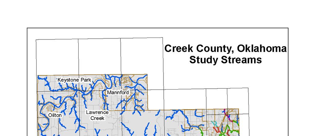
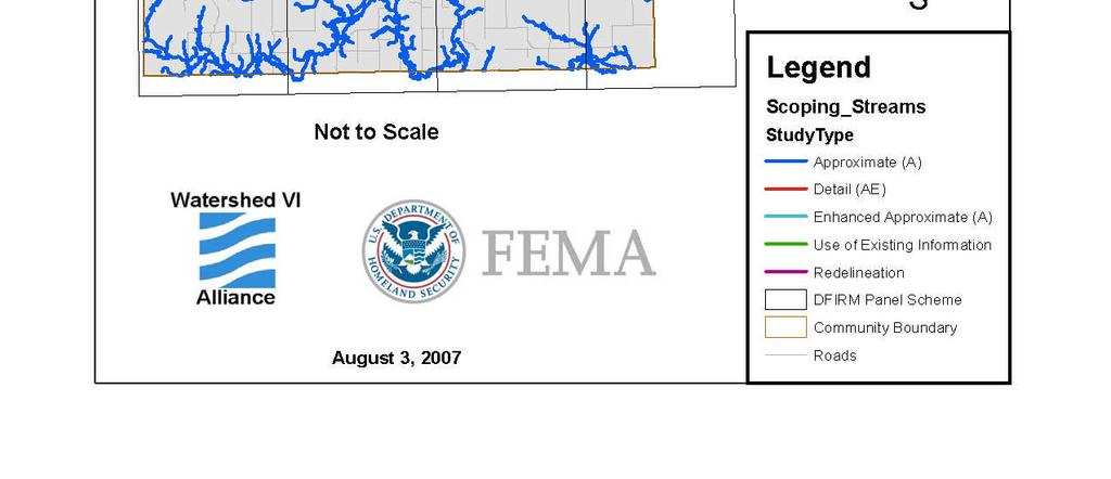
7 Creek County Outreach 7


8 8

9 9


10 10


11 11

12 Mid-Course Adjustment National Goals 12
13 Mid-Course Adjustment Arkansas Number of Counties Mapped Percentage Population in Mapped Counties Percentage Area of Counties Mapped (sq mi) Percentage Original Current % 60% 3,450,654 3,098, % 90% 69,898 38, % 55% 13
14 Map Mod Post Preliminary Counties 14
15 Oklahoma Active Map Mod Studies 15
16 FY 07 Funding Status Approximately 94% of the original FY 07 budget was provided from FEMA HQ. 77 of the Original 83 planned study starts occurred. Woodward only study postponed in Oklahoma. 100% of the FY 07 Funding has been awarded. All FY 07 Scoping Meetings are complete and all FY 07 Studies are Underway. 16
17 Oklahoma FY 07 Project Starts 17
18 Status of Oklahoma Counties Effective Payne 5/16/2007 LFD Issued McClain 5/16/2007 with Effective date of 11/16/2007 Near LFD Osage 10/2/2007(LFD) with an Effective date of 4/2/2008 Completing Appeals Cleveland Canadian Washington 18
19 Status of Oklahoma Counties (cont) Preliminary Maps Tulsa Oklahoma 02/28/2007-Starting Appeals/Protests 07/31/2007-CCO Meeting 9/25/07 Near Preliminary Maps -Estimated Date Comanche Creek Kay 09/30/ /30/ /30/2007 FY 07 Starts Cherokee, and Rogers07/30/2008 Carter, Garfield, Grady, Ottawa, Pittsburgh, Wagner 08/30/2008 Logan, Muskogee, and Okmulgee 09/30/2008 Pottawatomie 11/30/2008 Garvin and Stephens December 30, 2008 Watershed Concepts is the Study Contractor for all FY 07 Projects 19

20 Mapping Information Platform Creation of the MIP Mapping Information Platform Track status of studies Repository of FIS, DFIRMs, and development data 20
21 What s New in the MIP? MIP Champion initiative: FEMA Regional staff are actively participating in a MIP focus group to increase its usability, benefit, and value to the Map Mod program. They are also working to removing impediments to its use, and reducing the burden of reporting using the MIP Serve as a liaison between CTPs, IDIQs, OFAs, etc. and the FEMA HQ and NSP HQ staff who implement MIP changes 21
22 What s New in the MIP? As a result of MIP Champion involvement, the MIP Workflow is currently undergoing a major improvement. Highlights include: Redesigning data upload portlet to ease delivery of data to FEMA Having QC tools run automatically in the Workflow (DCS, HDM, etc.) Creating a management task so CTPs can manage cost data and allow subcontractors to perform engineering/gis work 22
23 What s New in the MIP? Service Pack 14, due in October, provides changes recommended by FEMA Regions and their mapping partners Online training will follow via Webex Transformed feedback mechanism into User Care initiative. Any user can suggest a change or report a bug 23
24 MIP Acceptance Major Effort to Ensure all Map Mod data is located on the MIP June 30th Initiative-Completed Update all studies to proper step in workflow. Dummy metadata used to move through workflow After June 30th -Underway Ensure all study data resides on the MIP 24
25 Oklahoma Studies with Levees 25
26 Levees Levees complicate the study process due to the certification / recertification requirements (44 CFR 65.10). Information is needed for certification / re-certification from the: Applicable USACE District Levee Owner or Sponsor Levee Maintenance Entity Levee Inspection Entity 26
27 Levees: Protection with Risk Levees are designed to provide specific level of protection They can be overtopped or fail in larger flood events They require regular maintenance and periodic upgrades to retain their level of protection FEMA urges people to understand their flooding risk involving levees 27
28 FEMA Levee Ownership FEMA has no levees; it does not own, operate, or maintain any. We only show other organizations levees on the maps. The levee owner must certify and maintain these levees for them to continue to be included. 28
29 FEMA Requirements FEMA s certification requirements for Levee Design, Construction, Operation and Maintenance to gain FEMA Accreditation. A. Certification Standard is 44 CFR Certification checklist is based on requirements from 44 CFR Revised date is October 1, B. Procedure Memorandum No. 34 (PM 34)-Certifcation Documents are available to submit within 30 days. Interim Guidance for Studies Including Levees August 22, 2005 C. Procedure Memorandum No. 43 (PM 43)-Need time to gather certification documents-24 months allowed. Guidelines for Identifying Provisionally Accredited Levees September 25, 2006 Revised March 16,
30 44 CFR Highlights To be certifiable, the levee system must be owned and operated by a public entity The levee owner has the ultimate responsibility of certifying the levee Design and Construction requirements Freeboard, Foundation, etc. Operation and Maintenance requirements O&M manual, maintenance records, etc. Federal Agency (USACE) who constructed levee can provide certification Levee must be certified/re-certified every time the map is changed 30
31 PM 34 Highlights Interim guidance to establish certification process (flowchart) Specifies that levee systems that are mapped by FEMA are designed, constructed, operated and maintained to standards (44 CFR 65.10) Requires obtaining verification that certification requirements are and continue to be met Requires that necessary certifications are provided by the responsible party 31
32 PM 43 Highlights-Revised March 2007 Created to prevent levee issues from holding up DFIRMs Allows 2 years to compile certification documentation Not allowed for any levee that requires any construction work to be done for certification Public versus Privately owned levees (PAL Scenario) PAL Agreement Recently Revised to include 1 year Maintenance Correction Period 32
33 Levee Checklist 33
34 FEMA Accreditation of Certification If adequate certification is provided and accepted, FEMA will accredit the levee as providing protection Communities becoming involved is key to achieving levee certification. If levee certification is not provided, the area will be mapped with the levee NOT providing protection 34
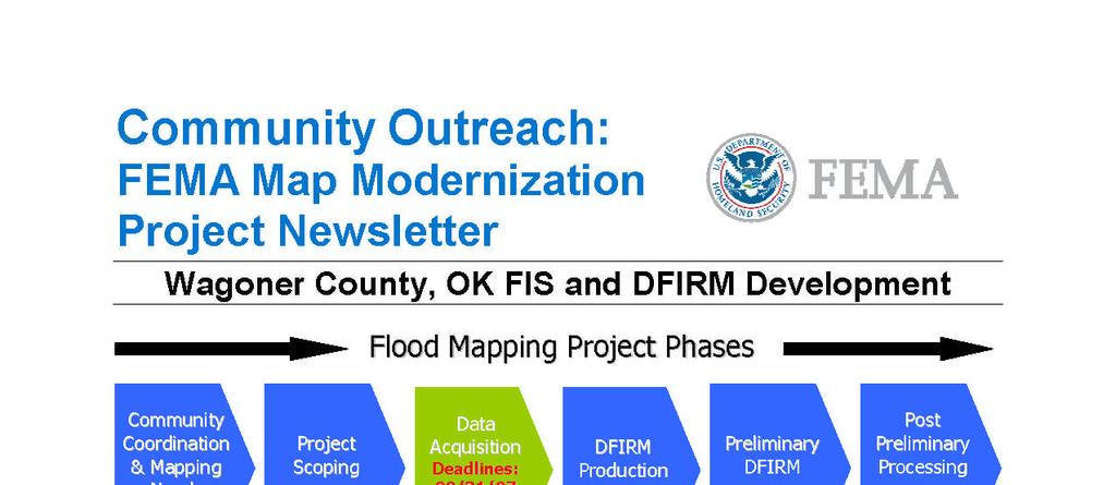
35 Map Mod Study Process ping Project Phases Community Coordination & Mapping Needs Assessment Project Scoping Topographic Data Acquisition and H & H Modeling DFIRM Production Preliminary DFIRM Post Preliminary Processing 30 Days 12+ Months O U T R E A C H 30 Days Days 1-8 Months Months Time frames given are approximate and will vary from study to study 35

36 Scoping Task Review Pre-Scoping Report if available Contact Community Schedule Scoping Meeting Hold Scoping Meeting Receive Input from Community Floodplain administrators Identify development trends Rank Streams based on in-accuracies on the current FIRM Determine the Basemap that will be used for the study Vector or Raster Finalize DFIRM Panel layout and scale sizes. Develop a Project Management Plan Develop a Scope of Project Populate Scoping Tool Meeting Layer Refine Potential Obstacles Report Develop a time and cost estimate 36
37 Sample Scoping Meeting Agenda 37

38 Production Phase to Preliminary DFIRMs Surveying Topography Development Base Map Hydrology Hydraulics Work Maps DFIRMs Incorporation of LOMCs Preliminary Map Distribution 38


39 Components of a Base + = Topography + Flood Data Digital FIRM 39
40 Post-Preliminary Phase Preliminary DFIRMs Coordination Consultation Officer (CCO) Meeting Public Notice 90-Day Appeals Period Appeals Resolution Letter of Final Determination 6 Month Compliance Period Effective Maps 40
41 Appeals/Protest Quick Facts APPEAL/PROTEST PROCESS TIME FRAME What is the basis for an appeal? The sole basis for an appeal is that you are in possession of knowledge or information indicating that the elevations proposed by FEMA are scientifically or technically incorrect. What is a protest? A protest is an objection to any information, other than the pr oposedbfe sshownonanfi Pmap. Release of Preliminary FIS/DFIRMs and Summary of Map Actions (SOMA) County will receive 3 copies of the Preliminary FIS text and DFIRMS Each incorporated community will receive 3 copies of the FIS text and three copies of the DFIRMs panels that pertain to that community. Community will have approximately 30 days to review FIS/DFIRMs FEMA will Schedule Community Coordination Meeting(s) After the Community Coordination Meeting(s) in approximately two to four weeks, FEMA places notification of Proposed BFE in the local newspaper and on FEMA web site. 41
42 Appeals/Protest Quick Facts(cont) There will be two publications in the local newspaper(s) within a 10 day period immediately following the notification to the community. The second publication will officially begin the 90-day appeal period. Community official will receive a certified letter with notification of the dates, the web site address and the name of the newspaper. The newspaper will state the streams studied, and instruct the reader to refer to the FEMA web site for the proposed BFEs. FEMA encourages that appeals be coordinated with the community officials To appeal the proposed BFEs, the appellant must have possession of information proving that the proposed BFEs are scientifically or technically incorrect Appeal/protest must be forwarded to FEMA, Denton Region VI Office FEMA Attention: Frank Pagano, Director Mitigation Division 800 North Loop 288 Denton, Texas
43 Appeals/Protest Quick Facts(cont) At the end of the 90-day appeal period, acknowledgement letters will be sent to community official with a copy to appellant indicating receipt of appeal and/or protest. Appeals and/or protested will be resolved in a timely manner. All correspondence during this period will be sent to the community official with a copy to the appellant. Once all appeals have been resolved, FEMA will issue a Letter of Final Determination (LFD) indicating that all proposed BFEs are final and the community has 6 months from the date of the letter that the DFIRMs will be effective. If necessary approximately 2 weeks before the effective date of the DFIRMs the community will receive a letter from FEMA revalidating LOMCs that are not shown on the DFIRMs because of scale limitations or because of time constraints. During this 6 month period, ordinances must be updated, revised, and/or adopted prior to the effective date of the DFIRMs and approved by FEMA Regional Office, Denton, Texas. Approximately 6 to 8 weeks before the effective date of DFIRMs the Map Service Center will forward effective maps. Reference-44 CFR-Part 67 Appeals from Proposed Flood Elevation Determinations 43
44 Compliance Period Compliance Period is 6 months in length. During the 6 month compliance period, the communities are required to adopt a new floodplain ordinance that recognizes the new maps. If a community has not passed the ordinance within the 6 month compliance period, the community will be suspended from the program. Maps become effective at the end of the 6 month compliance period. 44
45 Effective Maps The new effective maps are dated 6 months from the date of the LFD. During the compliance period, the Government Printing Office will be printing the new effective maps and FIS Report. The new maps will be distributed to the communities in the weeks preceding the effective date. The new maps become effective for flood insurance purposes. 45
46 46
Map Modernization Modernization Program
 FEMA Map Modernization Program Presented to Maryland Association of Floodplain and Stormwater Managers October 27, 2005 Map Modernization Program Autorun.exe 2 Map Modernization Program Outline Map Mod
Map Modernization State Business Plan for Ohio January 2004 Attachment #2
 Map Modernization State Business Plan for Ohio January 2004 Attachment #2 FEDERAL EMERGENCY MANAGEMENT AGENCY COOPERATING TECHNICAL PARTNERS MEMORANDUM OF AGREEMENT AGREEMENT is made on April 22, 2003,
Mingo County, WV Community Coordination Preliminary Flood Insurance Study and Flood Insurance Rate Map. Thursday, September 25, 2014
 Mingo County, WV Community Coordination Preliminary Flood Insurance Study and Flood Insurance Rate Map Thursday, September 25, 2014 Overview Preliminary Materials Preliminary FIS Report Digital Flood Insurance
MAP INDEX CHECKLIST NOTES:
 REVIEWING YOUR PRELIMINARY DFIRM PANELS AND FIS REPORT A GUIDE FOR COMMUNITY OFFICIALS When a Georgia community is presented with new Digital Flood Insurance Rate Map (DFIRM) panels, the State of Georgia,
$ FACTS ABOUT OKLAHOMA: WAGE STATE FACTS HOUSING MOST EXPENSIVE AREAS WAGE RANKING
 STATE #43 * RANKING In Oklahoma, the Fair Market Rent () for a two-bedroom apartment is $801. In order this level of and utilities without paying more than 30% of income on housing a household must earn
HEC Software and FEMA Submittals
 HEC Software and FEMA Submittals EWRI Workshop HEC Users Conference Larry Voice Risk Analysis FEMA Region VI April 12, 2010 Overview Flood Hazard Analysis Overview of Map Changes Accepted Model List Guidance
Criteria for Appeals of Flood Insurance Rate Maps. November 30, 201 1
 Criteria for Appeals of Flood Insurance Rate Maps November 30, 201 1 This document outlines the criteria for appealing proposed changes in flood hazard information on Flood Insurance Rate Maps (FIRMS)
Letter of Map Change Fundamentals
 Letter of Map Change Fundamentals FEMA Region III National Flood Insurance Program Essentials and Best Practices Jana Green, CFM, RAMPP Topics of Discussion Why Apply for a Letter of Map Change (LOMC)?
OKLAHOMA AD VALOREM MILL LEVIES,
 AE # 14038 OKLAHOMA AD VALOREM MILL LEVIES, FISCAL YEAR 2014 Assembled by Kirsten Rogers Student Assistant Sherri Schieffer Local Government Specialist Notie H. Lansford, Jr. Professor and Extension Economist
FEMA POLICY: GUIDANCE ON THE USE OF AVAILABLE FLOOD HAZARD INFORMATION
 FEMA POLICY: GUIDANCE ON THE USE OF AVAILABLE FLOOD HAZARD INFORMATION FEMA Policy #104-008-2 BACKGROUND The policy is for FEMA Headquarters, Regional program staff, and for the Field Staff at the Joint
Comparison of County Government Finances Among Different Size Counties
 Oklahoma Cooperative Extension Service AGEC-902 Comparison of County Government Finances Among Different Size Counties Notie H. Lansford Extension Economist Brian Lamoreaux Student Assistant County officers
AGENCY: Federal Emergency Management Agency, DHS. SUMMARY: Flood hazard determinations, which may include additions or
 This document is scheduled to be published in the Federal Register on 03/15/2019 and available online at https://federalregister.gov/d/2019-04871, and on govinfo.gov Billing Code 9110-12-P DEPARTMENT OF
What s New in FEMA Mapping?
 Discussion Topics What s New in FEMA Mapping? Eric Simmons September 6, 2018 FEMA Initiatives & Evolving Risk MAP FEMA s Flood Map Service Center National Flood Hazard Layer (NFHL) Draft NFHL and Changes
Residential Major Subdivision Review Checklist
 Residential Major Subdivision Review Checklist Plan Submittal Requirements: 2 full sets of stamped plans Electric submittal - all plans contained in a single PDF 3 full sets if commercial kitchen or dining
Final Report WI Flood Map Maintenance Project. Prepared For. The Wisconsin Department of Natural Resources Flood Map Maintenance Project
 Final Report WI Flood Map Maintenance Project Prepared For The Wisconsin Department of Natural Resources Flood Map Maintenance Project December 2007 TABLE OF CONTENTS INTRODUCTION 1 GIS DATA INVENTORY
AGENDA REPORT. Susan Healy Keene, AICP, Director of Community Development
 AGENDA REPORT Item Number: To: From: Subject: F i Honorable Mayor & City Council Susan Healy Keene, AICP, Director of Community Development UPDATE ON IMPLEMENTATION OF AMENDED RENT STABILIZATION ORDINANCE
Residential Minor Subdivision Review Checklist
 Residential Minor Subdivision Review Checklist Plan Submittal Requirements: 2 full sets of stamped plans Electric submittal - all plans contained in a single PDF 3 full sets if commercial kitchen or dining
Developing Mitigation Projects. Molly J. O Toole, P.E., D.WRE, CFM
 Developing Mitigation Projects Molly J. O Toole, P.E., D.WRE, CFM Mitigation Hazard mitigation is defined as any sustained action taken to reduce or eliminate long-term risk to life and property from a
[Docket ID FEMA ; Internal Agency Docket No. FEMA-B-1406] AGENCY: Federal Emergency Management Agency, DHS.
![[Docket ID FEMA ; Internal Agency Docket No. FEMA-B-1406] AGENCY: Federal Emergency Management Agency, DHS.](/thumbs/95/124849871.jpg "[Docket ID FEMA ; Internal Agency Docket No. FEMA-B-1406] AGENCY: Federal Emergency Management Agency, DHS.") This document is scheduled to be published in the Federal Register on 04/22/2014 and available online at http://federalregister.gov/a/2014-09184, and on FDsys.gov 1 Billing Code 9110-12-P DEPARTMENT OF
This document is scheduled to be published in the Federal Register on 04/22/2014 and available online at http://federalregister.gov/a/2014-09184, and on FDsys.gov 1 Billing Code 9110-12-P DEPARTMENT OF
PROPERTY TAX IS A PRINCIPAL REVENUE SOURCE
 TAXABLE PROPERTY VALUES: EXPLORING THE FEASIBILITY OF DATA COLLECTION METHODS Brian Zamperini, Jennifer Charles, and Peter Schilling U.S. Census Bureau* INTRODUCTION PROPERTY TAX IS A PRINCIPAL REVENUE
Floodplain Management: New York State Role
 Floodplain Management: New York State Role Establish development/building standards State building code Model local law for flood damage prevention Provide technical assistance to local communities/agencies
Arlington County, Virginia. Internal Audit of the Real Estate Assessment Appeals Process Calendar Year Ended December 31, 2014
 Arlington County, Virginia Internal Audit of the Real Estate Assessment Appeals Process Calendar Year Ended December 31, 2014 Table of Contents Transmittal Letter... 1 Executive Summary... 2-9 Background...
HUD Multifamily Utility Benchmarking Webinar Series Webinar 2: Creating a Plan and Managing Data for Multifamily Utility Benchmarking
 HUD Multifamily Utility Benchmarking Webinar Series Webinar 2: Creating a Plan and Managing Data for Multifamily Utility Benchmarking April 20, 2017 Webinar Logistics Submit content related questions via
[Docket ID FEMA ; Internal Agency Docket No. FEMA-B AGENCY: Federal Emergency Management Agency, DHS.
 This document is scheduled to be published in the Federal Register on 09/25/2017 and available online at https://federalregister.gov/d/2017-20468, and on FDsys.gov 1 Billing Code 9110-12-P DEPARTMENT OF
Letters of Map Amendment- Out as Shown
 Letters of Map Amendment- Out as Shown While digital Flood Insurance Rate Maps (DFIRM s) have made it easier to determine if a structure (or building site) is in the special flood hazard area (SFHA), many
National Flood Insurance Program (NFIP) MT-1 Presentation. David Mummert, Michael Baker Jr., Inc.
 MT-1 Presentation. David Mummert, Michael Baker Jr., Inc.") National Flood Insurance Program (NFIP) MT-1 Presentation David Mummert, Michael Baker Jr., Inc. MT-1 Letters of Map Change (LOMCs) LOMC Review By FEMA FEMA required to notify the applicant in writing
National Flood Insurance Program (NFIP) MT-1 Presentation David Mummert, Michael Baker Jr., Inc. MT-1 Letters of Map Change (LOMCs) LOMC Review By FEMA FEMA required to notify the applicant in writing
[Docket ID FEMA ; Internal Agency Docket No. FEMA-B-1751] AGENCY: Federal Emergency Management Agency, DHS.
![[Docket ID FEMA ; Internal Agency Docket No. FEMA-B-1751] AGENCY: Federal Emergency Management Agency, DHS.](/thumbs/87/95259803.jpg "[Docket ID FEMA ; Internal Agency Docket No. FEMA-B-1751] AGENCY: Federal Emergency Management Agency, DHS.") This document is scheduled to be published in the Federal Register on 10/26/2017 and available online at https://federalregister.gov/d/2017-23228, and on FDsys.gov 1 Billing Code 9110-12-P DEPARTMENT OF
This document is scheduled to be published in the Federal Register on 10/26/2017 and available online at https://federalregister.gov/d/2017-23228, and on FDsys.gov 1 Billing Code 9110-12-P DEPARTMENT OF
SUBJECT: Status Report on Executive Order : DATE: June 27, 2017 Improving Safety of Non-Permitted Spaces While Avoiding Displacement INFORMATION
 DISTRIBUTION DATE: June 27, 2017 MEMORANDUM TO: HONORABLE MAYOR & CITY COUNCIL FROM: SABRINA LANDRETH SUBJECT: Status Report on Executive Order 2017-1: DATE: June 27, 2017 Improving Safety of Non-Permitted
14+/- Acres Zoned Commercial
 14+/- Acres Zoned Commercial Hwy 75 & 151st St, Glenpool OK - Commercial Land For Sale School and Sports Park Points of Interest 1,269+/- Frontage Developing Area Utilities Present Billboards Allowed Zoned
APPLICATION PROCEDURES FOR A MAJOR SUBDIVISION PRELIMINARY PLAT
 APPLICATION PROCEDURES FOR A DEFINITION: The subdivision of a tract of land into at least three (3) residential, commercial, or industrial parcels, including the remainder of the original parcel, fronting
[Docket ID FEMA ; Internal Agency Docket No. FEMA-B-1518] AGENCY: Federal Emergency Management Agency, DHS.
![[Docket ID FEMA ; Internal Agency Docket No. FEMA-B-1518] AGENCY: Federal Emergency Management Agency, DHS.](/thumbs/87/97204602.jpg "[Docket ID FEMA ; Internal Agency Docket No. FEMA-B-1518] AGENCY: Federal Emergency Management Agency, DHS.") This document is scheduled to be published in the Federal Register on 06/08/ and available online at http://federalregister.gov/a/-13857, and on FDsys.gov 1 9110-12-P DEPARTMENT OF HOMELAND SECURITY Federal
This document is scheduled to be published in the Federal Register on 06/08/ and available online at http://federalregister.gov/a/-13857, and on FDsys.gov 1 9110-12-P DEPARTMENT OF HOMELAND SECURITY Federal
Assessor. Mission Statement: Functions: Long Term Goals: Page 1 of 6
 Assessor Mission Statement: The mission of the Assessor s Office is to create accurate, equitable, and timely property tax assessments to fund public services; and to be a source of current, accurate property
AGENCY: Federal Emergency Management Agency, DHS. SUMMARY: Comments are requested on proposed flood hazard determinations, which
 This document is scheduled to be published in the Federal Register on 02/05/2013 and available online at http://federalregister.gov/a/2013-02455, and on FDsys.gov 1 Billing Code 9110-12-P DEPARTMENT OF
An Audit Report on PROPERTY MANAGEMENT AND TENANT SERVICES. January 2019 Project #
 An Audit Report on PROPERTY MANAGEMENT AND TENANT SERVICES January 2019 Project # 20190201 Executive Summary Property Management provides management and tenant services for approximately 88 state agencies
GREATER TORONTO HOME BUILDERS ASSOCIATION PRESENTS CONDOMINIUMS: START TO FINISH
 GREATER TORONTO HOME BUILDERS ASSOCIATION PRESENTS CONDOMINIUMS: START TO FINISH GREATER TORONTO HOME BUILDERS ASSOCIATION PRESENTS CONDOMINIUMS: START TO FINISH Today s panel of expert professional consultants:
[Docket ID FEMA ; Internal Agency Docket No. FEMA-B-1806] AGENCY: Federal Emergency Management Agency, DHS.
![[Docket ID FEMA ; Internal Agency Docket No. FEMA-B-1806] AGENCY: Federal Emergency Management Agency, DHS.](/thumbs/83/87134658.jpg "[Docket ID FEMA ; Internal Agency Docket No. FEMA-B-1806] AGENCY: Federal Emergency Management Agency, DHS.") This document is scheduled to be published in the Federal Register on 03/09/2018 and available online at https://federalregister.gov/d/2018-04782, and on FDsys.gov 1 Billing Code 9110-12-P DEPARTMENT OF
This document is scheduled to be published in the Federal Register on 03/09/2018 and available online at https://federalregister.gov/d/2018-04782, and on FDsys.gov 1 Billing Code 9110-12-P DEPARTMENT OF
[Docket ID FEMA ; Internal Agency Docket No. FEMA-B-1808] AGENCY: Federal Emergency Management Agency, DHS.
![[Docket ID FEMA ; Internal Agency Docket No. FEMA-B-1808] AGENCY: Federal Emergency Management Agency, DHS.](/thumbs/82/86021413.jpg "[Docket ID FEMA ; Internal Agency Docket No. FEMA-B-1808] AGENCY: Federal Emergency Management Agency, DHS.") This document is scheduled to be published in the Federal Register on 03/16/2018 and available online at https://federalregister.gov/d/2018-05415, and on FDsys.gov 1 Billing Code 9110-12-P DEPARTMENT OF
This document is scheduled to be published in the Federal Register on 03/16/2018 and available online at https://federalregister.gov/d/2018-05415, and on FDsys.gov 1 Billing Code 9110-12-P DEPARTMENT OF
Rough River Lake Flowage Easement Encroachment Resolution:
 Rough River Lake Flowage Easement Encroachment Resolution: Rough River Lake Louisville District LRD November 2017 US Army Corps of Engineers Why are we here? Summarize the Flowage Easement Encroachment
A Guide to the Municipal Planning Process in Saskatchewan
 A Guide to the Municipal Planning Process in Saskatchewan A look at the municipal development permit and the subdivision approval process in Saskatchewan May 2008 Prepared By: Community Planning Branch
GIS Based Tools for County Road Management Right-of-Way Land Value Analysis. January 12, 2012
 GIS Based Tools for County Road Management Right-of-Way Land Value Analysis January 12, 2012 Reasons for Needing Accurate Land Values Asset Management 1999 GASB Statement 34 Corridor Studies Scoping Studies
River Rock Estates Sketch Plan, a proposed major subdivision in S24, T35N R2W NMPM on County Rd 119 (PLN18-336)
") MEMORANDUM Archuleta County Development Services Planning Department 1122 HWY 84 P. O. Box 1507 Pagosa Springs, Colorado 81147 970-264-1390 Fax 970-264-3338 TO: Archuleta County Planning Commission FROM:
MEMORANDUM Archuleta County Development Services Planning Department 1122 HWY 84 P. O. Box 1507 Pagosa Springs, Colorado 81147 970-264-1390 Fax 970-264-3338 TO: Archuleta County Planning Commission FROM:
MT 1, MT 2, Elevation Certificates & the Role of Surveyors
 MT 1, MT 2, Elevation Certificates & the Role of Surveyors Rocky Mountain Surveyors Summit March 3, 2016 Floods are acts of God, but flood losses are largely acts of man. - Dr. Gilbert White the father
Introduction of the Authority Online Housing Credit Management System (HCMS)
") Ralph M. Perrey, Executive Director Tennessee Housing Development Agency 404 James Robertson Parkway, Suite 1200 Nashville, Tennessee 37243-0900 www.thda.org TO: FROM: SUBJECT: Recipients of Low-Income
Ralph M. Perrey, Executive Director Tennessee Housing Development Agency 404 James Robertson Parkway, Suite 1200 Nashville, Tennessee 37243-0900 www.thda.org TO: FROM: SUBJECT: Recipients of Low-Income
DENTON Developer's Handbook
 DENTON Developer's Handbook A guide for land development in the City of Denton Department of Development Services 2017 2 Table of Contents 1. City of Denton Development Process...5 Role of the Development
4/1/2016. Your Instructor Today Is: Derek Antoine Maintenance and Management Clinic
 Your Instructor Today Is: Derek Antoine Illinois Association of Housing Authorities 2016 Maintenance and Management Clinic 2015 The Nelrod Company, Fort Worth, Texas. All rights reserved. This on-line
Chapter 14 Technical Safety Authority of Saskatchewan Inspecting Elevating Devices 1.0 MAIN POINTS
 Chapter 14 Technical Safety Authority of Saskatchewan Inspecting Elevating Devices 1.0 MAIN POINTS The Technical Safety Authority of Saskatchewan (TSASK) administers Saskatchewan s safety programs for
HUD Multifamily Southwest Region
 HUD Multifamily Southwest Region Southwestern Affordable Housing Management Association (SWAHMA) March 17-18, 2015 Presentation Agenda Kelly Haines Regional Director 1. MFT Transformation Wave 1 Overview
PRELIMINARY PLAT Checklist
 PRELIMINARY PLAT Checklist 3715 Bridgeport Way W University Place, WA 98466 PH: (253) 566-5656 FAX: (253) 460-2541 This is a checklist of materials required for a Preliminary Plat. This checklist is provided
Establishing a Wetland Bank in Minnesota
 Establishing a Wetland Bank in Minnesota Updated February 1, 2018 This document provides a general summary of the key steps in establishing an individual wetland bank site within the state wetland banking
The Promised Land in Sight Preliminary Issuance on a LAMP Study
 The Promised Land in Sight Preliminary Issuance on a LAMP Study Agenda Project Location: more levees than we can count! LLPT meetings Results Bottom Line Project Location 3 The Promised Land in Sight Preliminary
National Flood Insurance Program
 National Flood Insurance Program Base Flood Elevations in Zone A Streams Surveyor Training Presented by Thomas F. Smith, PE, PLS January 22, 2018 1 FEMA Region III Mitigation Division Floodplain Management
MnDOT Contract No Exhibit B. Scope of Work. Scope of Work
 MnDOT Contract No. 1032993 Contract General Description The purpose of this contract is to provide the State with the survey accurate re-establishment of designated Public Land Survey section boundaries
Application and Project Documentation - Land Trust Accreditation Commission
 A complete application and all required attachments must be provided from each applicant to demonstrate that the organization is meeting all of the accreditation indicator elements and program requirements.
DEPARTMENT OF HOUSING AND URBAN DEVELOPMENT. [Docket No. FR-5875-N-01]
![DEPARTMENT OF HOUSING AND URBAN DEVELOPMENT. [Docket No. FR-5875-N-01]](/thumbs/87/95114831.jpg "DEPARTMENT OF HOUSING AND URBAN DEVELOPMENT. [Docket No. FR-5875-N-01]") This document is scheduled to be published in the Federal Register on 09/07/2016 and available online at http://federalregister.gov/a/2016-21226, and on FDsys.gov DEPARTMENT OF HOUSING AND URBAN DEVELOPMENT
This document is scheduled to be published in the Federal Register on 09/07/2016 and available online at http://federalregister.gov/a/2016-21226, and on FDsys.gov DEPARTMENT OF HOUSING AND URBAN DEVELOPMENT
Using HEROS as an FHA Partner
 Using HEROS as an FHA Partner The purpose of this document is to provide instructions to consultants and lenders assisting with environmental reviews for Multifamily FHA-insured projects. Consultants will
BUILDINGS, LAND AND LAND IMPROVEMENTS
 Approved: Effective: February 19, 2014 Office: Office of Comptroller, General Accounting Topic No. 350-090-315-g Department of Transportation BUILDINGS, LAND AND LAND IMPROVEMENTS PURPOSE: To define requirements
Single Family Housing Policy Handbook: FHA Connection 203k Calculator and Other System Enhancements
 Office of Single Family Program Development Single Family Housing Policy Handbook: FHA Connection 203k Calculator and Other System Enhancements April 28, 2016 Last Updated: 4/27/16 Presented by: Kevin
Ohio Department of Transportation. Division of Engineering. Office of Real Estate. Synergy. Real Estate Business Analysis
 Ohio Department of Transportation Division of Engineering Office of Real Estate Synergy Real Estate Business Analysis Appraisal System Specification Version 1.02 Revision History Date Version Modified
Prince George s County, Maryland Executive Summary of Module 3: Zoning Ordinance
 Prince George s County, Maryland Executive Summary of Module 3: Zoning Ordinance September 2016 Subtitle 27: Zoning Ordinance Division 27-1: General Provisions Division 27-2: Administration Division 27-6:
AGENCY: Federal Emergency Management Agency, DHS. SUMMARY: Flood hazard determinations, which may include additions or
 This document is scheduled to be published in the Federal Register on 08/18/2016 and available online at http://federalregister.gov/a/2016-19668, and on FDsys.gov 1 Billing Code 9110-12-P DEPARTMENT OF
Features Guide. Enhancements. Mortgage Calculators VERSION 7. May 2008
 Features Guide VERSION 7 May 2008 Copyright 2002-2008 SuperTech Software All rights reserved. Printed in Australia. Enhancements This document describes new features and enhancements in POSH. Mortgage
LOT LINE ADJUSTMENT GENERAL INFORMATION AND
 LOT LINE ADJUSTMENT GENERAL INFORMATION AND APPLICATION Mariposa County Planning Department 5100 Bullion Street, P.O. Box 2039 Mariposa, CA 95338 Telephone (209) 966-5151 FAX (209) 742-5024 www.mariposacounty.org
HUD Announces the Return Of Management and Occupancy Reviews. Inside This Issue. HUD Announces the Return of Management
 Inside This Issue HUD Announces the Return Of Management and Occupancy Reviews HUD Announces the Return of Management and Occupancy Reviews Spotlight on Compliance: EIV Reports 1 5 As you may be aware
Guide to Combined Preliminary and Final Plats
 Guide to Combined Preliminary and Final Plats Introduction The Douglas County is committed to providing open, transparent application processes to the public. This Guide is provided to assist anyone interested
Project Name: (Name as it appears in ESNAPS.) Spring Care Association
 Spring Care Association") Page 1 of 4 U.S. Department of Housing and Urban Development 451 Seventh Street, SW Washington, DC 20410 www.hud.gov espanol.hud.gov Environmental Review for Continuum of Care (CoC) Rental Assistance Project
Page 1 of 4 U.S. Department of Housing and Urban Development 451 Seventh Street, SW Washington, DC 20410 www.hud.gov espanol.hud.gov Environmental Review for Continuum of Care (CoC) Rental Assistance Project
PART ONE - GENERAL INFORMATION
 Corrected Date: Page 7 Date of Submittal Changed to Coincide with Submittal Date on Page 5 PART ONE - GENERAL INFORMATION A. INTRODUCTION B. Background Miami Shores Village is soliciting responses to this
RECORDKEEPING PROCESS. All ACEDP grantees are required to develop a recordkeeping system that is comprehensive, well-organized and easy to review.
 RECORDKEEPING PROCESS I. INTRODUCTION All ACEDP grantees are required to develop a recordkeeping system that is comprehensive, well-organized and easy to review. The recordkeeping system below provides
Affirmative Fair Housing Marketing (AFHM) Plan Multifamily Housing
 Plan Multifamily Housing") Affirmative Fair Housing Marketing (AFHM) Plan Multifamily Housing U.S. Department of Housing and Urban Development Office of Fair Housing and Equal Opportunity 1a. Project Name & Address (including County,
Affirmative Fair Housing Marketing (AFHM) Plan Multifamily Housing U.S. Department of Housing and Urban Development Office of Fair Housing and Equal Opportunity 1a. Project Name & Address (including County,
Federal Emergency Management Agency
 Page 1 of 3 Date: July 21, 2016 Case No.: 16-05-5203A LOMA COMMUNITY AND MAP PANEL INFORMATION COMMUNITY KEWAUNEE COUNTY, WISCONSIN (Unincorporated Areas) Federal Emergency Management Agency Washington,
R e z o n i n g A p p l i c a t i o n S u b m i s s i o n R e q u i r e m e n t s
 H O R R Y C O U N T Y P L A N N I N G & Z O N I N G 1 3 0 1 2 N D A V E., S U I T E 1 D - 0 9 C O N W A Y, S. C. 2 9 5 2 6 P H O N E : 8 4 3. 9 1 5. 5 3 4 0 F A X : 8 4 3. 9 1 5. 6 3 4 1 R e z o n i n
EARLY LEARNING COALITION OF OSCEOLA COUNTY
 Page of 1 of 9 POLICY STATEMENT The Coalition shall adhere to Federal and state laws, regulations, and rules requiring the implementation of proper controls related to the management, maintenance, reporting,
APPRAISAL MANAGEMENT COMPANY
 APPRAISAL MANAGEMENT COMPANY STANDARDS OF GOOD PRACTICE IN APPRAISAL MANAGEMENT JANUARY 6, 2010 POST OFFICE BOX 1196 WEXFORD, PA 15090 (P) 724-934-1420 (F) 724-934-0057 (W) WWW.TAVMA.ORG APPRAISAL MANAGEMENT
CHESAPEAKE BAY PRESERVATION AREA EXCEPTION APPLICATION INSTRUCTIONS
 City of Chesapeake Department of Planning Post Office Box 15225 Chesapeake, Virginia 23328-5225 (757) 382-6176 FAX (757) 382-6406 CHESAPEAKE BAY PRESERVATION AREA EXCEPTION APPLICATION INSTRUCTIONS PURPOSE
TARGETED VERIFICATION DOCUMENTS
 TARGETED VERIFICATION DOCUMENTS In an effort to reduce the amount of documentation provided in the overall application, the Commission has shifted some questions and documentation to the Pre-Application
Government Furnished Property What Is It???
 1 Government Furnished Property What Is It??? Barbara A Finnegan, CPPM CF 2 Government Furnished Property What Is It??? Agenda Introduction Topics Define GFP Acquisition Control of GFP Scheduling: receipt
LIS Development Project and Measures Proposed to Enhance Trust in the Land Administration System in Uganda
 Project for Design, Supply, Installation and Implementation of the Land Information System and Securing of Land Records (DeSILISoR) LIS Development Project and Measures Proposed to Enhance Trust in the
ASSESSOR'S OFFICE I. DEPARTMENT MISSION OR MANDATE OR GOAL
 ASSESSOR'S OFFICE I. DEPARTMENT MISSION OR MANDATE OR GOAL The purpose of the Assessor's Office is to produce a timely roll of all property subject to local assessment; administer legally permissible exemptions;
City of Prior Lake APPLICATION FOR REGISTERED LAND SURVEY
 Case File No. Property Identification No. City of Prior Lake APPLICATION FOR REGISTERED LAND SURVEY Requested Action Brief description of proposed project (Please describe the proposed amendment, project,
REQUEST FOR PROPOSALS (A )
") CITY OF TUSCALOOSA ) STATE OF ALABAMA ) REQUEST FOR PROPOSALS (A18-1471) TO: FROM: RE: Qualified Firms The City of Tuscaloosa, Alabama Request for Proposals for Development of Analysis of Impediment to
CITY OF TUSCALOOSA ) STATE OF ALABAMA ) REQUEST FOR PROPOSALS (A18-1471) TO: FROM: RE: Qualified Firms The City of Tuscaloosa, Alabama Request for Proposals for Development of Analysis of Impediment to
Figures List for New LPA Manual
 EPG 136.1 Introduction 136.1.10.1 136.1.1 LPA Planning Process Chart 136.1.10.2 136.1.2 MoDOT Programming Process Chart 136.1.10.3 136.1.3 Right of Way Process 136.1.10.4 136.1.4 Preliminary Plans Process
For more information on how to compile and submit project documentation see our website and the User Manual.
 PROJECT DOCUMENTATION CHECKLIST Documentation for projects selected by the Commission is required as part of each renewal application. This checklist is required for each project selected, to help you
Draft Integrated Feasibility Report and Environmental Assessment and Draft Finding of No Significant Impact
 Draft Integrated Feasibility Report and Environmental Assessment and Draft Finding of No Significant Impact APPENDIX F: REAL ESTATE Whittier, Alaska June 2018 Pacific Ocean Division DRAFT REAL ESTATE
Date: March 2018 TOWN OF WATERFORD Department of Assessment
 Date: March 2018 TOWN OF WATERFORD 1. Overview: The purpose of this workshop is to explain the Assessment Disclosure Notice, how assessments are derived and how to challenge your assessment if you do not
AGENCY: Federal Emergency Management Agency, DHS. SUMMARY: Comments are requested on proposed flood hazard determinations, which
 This document is scheduled to be published in the Federal Register on 05/21/2013 and available online at http://federalregister.gov/a/2013-12018, and on FDsys.gov 1 Billing Code 9110-12-P DEPARTMENT OF
Conservation Easement Stewardship
 Conservation Easements are effective tools to preserve significant natural, historical or cultural resources. Conservation Easement Stewardship Level of Service Standards March 2013 The mission of the
ADMINISTRATION FIXED ASSETS Board of Trustees Approval: 09/12/2001 CHAPTER 1 Date of Last Cabinet Review: 12/12/2017 POLICY 6.
 FIXED ASSETS Board of Trustees Approval: 09/12/2001 POLICY 6.01 Page 1 of 1 I. POLICY Salt Lake Community College shall maintain a system to account for institutional property under the control and responsibility
Using HEROS as a RAD Partner
 Using HEROS as a RAD Partner The purpose of this document is to provide instructions to third party providers and Public Housing Authorities (PHAs) assisting HUD with Part 50 environmental reviews for
[Docket ID FEMA ; Internal Agency Docket No. FEMA-B-1809] AGENCY: Federal Emergency Management Agency, DHS.
![[Docket ID FEMA ; Internal Agency Docket No. FEMA-B-1809] AGENCY: Federal Emergency Management Agency, DHS.](/thumbs/96/128473675.jpg "[Docket ID FEMA ; Internal Agency Docket No. FEMA-B-1809] AGENCY: Federal Emergency Management Agency, DHS.") This document is scheduled to be published in the Federal Register on 03/09/2018 and available online at https://federalregister.gov/d/2018-04780, and on FDsys.gov 1 Billing Code 9110-12-P DEPARTMENT OF
This document is scheduled to be published in the Federal Register on 03/09/2018 and available online at https://federalregister.gov/d/2018-04780, and on FDsys.gov 1 Billing Code 9110-12-P DEPARTMENT OF
Audit Rent... 3 Calculate Rent... 3 Verify and Accept Rent... 4 Print Tenant Rent Report... 4 Print Revised Tenant Rent Report...
 Rent Calc Rent Calculation Tabs Prompt Tab... 1 Family Tab... 1 Income Tab... 1 Assets Tab... 1 Detail Tab... 2 Summary Tab... 2 History Tab... 2 Audit Tab... 2 Comments Tab... 2 Amounts Tab... 2 Control
SUBDIVISION APPLICATION
 SUBDIVISION APPLICATION Community Planning and Economic Development Development Services Division 250 South 4 th Street, Room 300 Minneapolis MN 55415-1316 612-673-3000 This application packet is used
AMC Track Presentation Austin Christensen Founder & CCO - Validox. Appraisal Manager Compliance Techniques
 AMC Track Presentation Austin Christensen Founder & CCO - Validox Appraisal Manager Compliance Techniques Who Is An Appraisal Manager? 1. Staff at an Appraisal Management Company 2. Chief Appraiser 3.
Property Rights Acquisition and Mitigation Plan v.4
 DRAFT Property Rights Acquisition and Mitigation Plan v.4 ADA Accessible Version August 13, 2018 This is a draft Property Rights Acquisition and Mitigation Plan and the Diversion Authority requests MDNR
Neighborhood Stabilization Program Frequently Asked Questions
 Neighborhood Stabilization Program Frequently Asked Questions Q: Are the insurance requirements (in XVIII) uniform to all applicants, including the non-profits? Yes, the insurance requirements are required
THE LEGAL STUFF. DIY Joint Venture Kit DISCLAIMER
 THE LEGAL STUFF DISCLAIMER THIS PUBLICATION IS INTENDED TO PROVIDE GENERAL INFORMATION ONLY. IT DOES NOT PURPORT TO BE A LEGAL, ACCOUNTING OR FINANCIAL ADVICE. IT IS NOT INTENDED TO BE A SUBSTITUTE FOR
Flood Hazard Development Permit Application & Permit Forms. For Communities with Coastal Velocity Zones [60.3(e)] CONTENTS
![Flood Hazard Development Permit Application & Permit Forms. For Communities with Coastal Velocity Zones [60.3(e)] CONTENTS](/thumbs/76/74346075.jpg "Flood Hazard Development Permit Application & Permit Forms. For Communities with Coastal Velocity Zones [60.3(e)] CONTENTS") Flood Hazard Development Permit Application & Permit Forms For Communities with Coastal Velocity Zones [60.3(e)] CONTENTS 1. Decision Tree 2. Flood Hazard Development Permit Application 3. Flood Hazard
Flood Hazard Development Permit Application & Permit Forms For Communities with Coastal Velocity Zones [60.3(e)] CONTENTS 1. Decision Tree 2. Flood Hazard Development Permit Application 3. Flood Hazard
PART 2.7 DEPARTMENT OF GOVERNMENT SERVICES REAL ESTATE REGULATION
 PART 2.7 DEPARTMENT OF GOVERNMENT SERVICES REAL ESTATE REGULATION Executive Summary The Financial Services Regulation Division (the Division) within the Consumer and Commercial Affairs Branch of the Department
Overview of CRS reward program - discounts for communities going above and beyond the minimal NFIP, class 9-5%, class 8-10% discount administered by
 Overview of CRS reward program - discounts for communities going above and beyond the minimal NFIP, class 9-5%, class 8-10% discount administered by ISO - corporation based out of New Jersey goals - strengthen
LLANO CENTRAL APPRAISAL DISTRICT REAPPRAISAL PLAN FOR TAX YEARS 2017 & 2018 AS ADOPTED BY THE BOARD OF DIRECTORS
 LLANO CENTRAL APPRAISAL DISTRICT REAPPRAISAL PLAN FOR TAX YEARS 2017 & 2018 AS ADOPTED BY THE BOARD OF DIRECTORS TABLE OF CONTENTS ITEM PAGE Executive Summary 5 Revaluation Decision (Statutory or Administrative)
FINAL APPLICATION. N.J.A.C. 7: (Minor disposals or diversions of parkland)
") FINAL APPLICATION N.J.A.C. 7:36-26.6 (Minor disposals or diversions of parkland) PRIOR TO SUBMITTING THE FINAL APPLICATION: The pre-application must be reviewed by the and the applicant must be given permission
FINAL APPLICATION N.J.A.C. 7:36-26.6 (Minor disposals or diversions of parkland) PRIOR TO SUBMITTING THE FINAL APPLICATION: The pre-application must be reviewed by the and the applicant must be given permission
DWR REAL ESTATE COORDINATION PLAN
 DWR REAL ESTATE COORDINATION PLAN Exhibit E DWR PROPERTY ACQUISTION PLAN EXHIBIT E Revised Date: 5 10 18 DWR PROPERTY ACQUISTION PLAN EXHIBIT E Revised Date: 5-10-2018 California WaterFix Real Estate Coordination