Z-MAX BLVD HARRISBURG, NC OFFERING MEMORANDUM
|
|
|
- Prosper Black
- 6 years ago
- Views:
Transcription

1 Z-MAX BLVD HARRISBURG, NC OFFERING MEMORANDUM
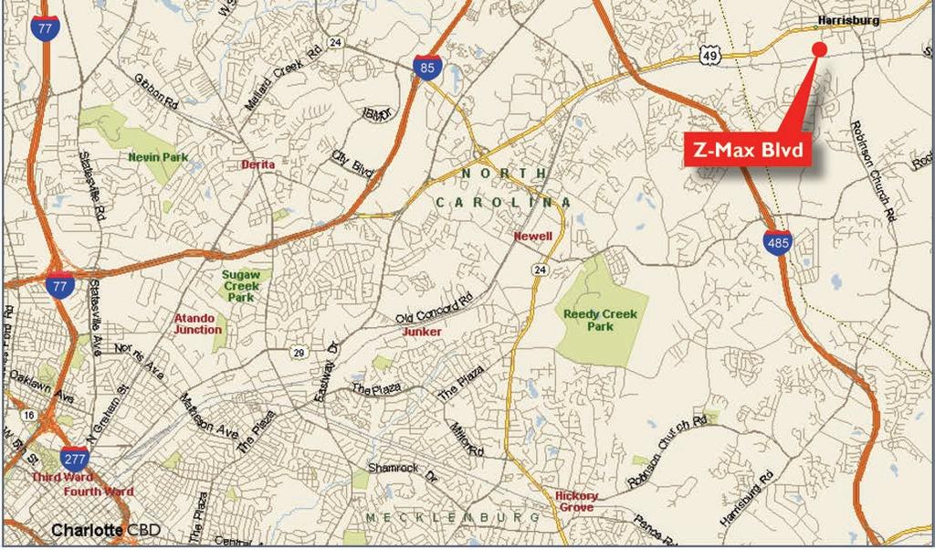
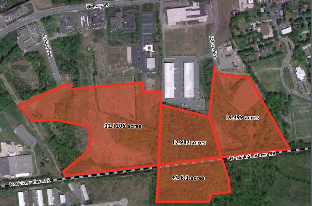
2 INVESTMENT HIGHLIGHTS List Price: $2,445,500 Location: Southeast quadrant of NC Hwy 49 and I-485 at the southern terminus of Z-Max Boulevard extending south from NC Hwy. 49 in Harrisburg, NC, just 2.5 miles east of the I-485 and NC-49 interchange. Size: 73 acres comprised of 3 parcels with Cabarrus County PIN s ( acres), ( acres), and ( acres) for a total of acres. Furthermore, approximately 10 acres of the property are on the south side of the Railway with no direct access except from across the Railway right of way. Norfolk Southern Rail Access: The site is bifurcated by the Norfolk Southern Railway with roughly 63 acres of the site located north of the railway and 10 acres located to the south. As such, the site has 3,000 ft of frontage along the track and as a result has been identified by Norfolk Southern as eligible for a rail spur, the preliminary renderings are included and discussed on the following pages. Zoning: Zoned Light Industrial (I-1) and Rural Estate (RE) by the Town of Harrisburg. The portion of the site to the north of the railway ( 63 acres) is under the I-1 designation with the portion of the site to the south of the railway ( 10 acres) is under the RE designation. Utilities: Water and sewer are site adjacent and contain capacity for industrial uses. Easements: There is a sewer easement running through the site from the north to south near the eastern property boundary as well a gas easement running along the western boundary of the site, neither of which overly encumber the site. Additionally, there are no other easements noted that will effect the developability of the land. For more information contact: Warren Snowdon, SIOR (704) warren.snowdon@thalhimer.com David Hanna (704) david.hanna@thalhimer.com
3 MAPS 3
4 LOCATION The site is located at the southern terminus of Z-Max Boulevard extending south from NC Hwy. 49 in Harrisburg, NC, just 2.5 miles east of the I-485 and NC-49 interchange. The site is also accessible from the southern terminus of Cedar Drive which also extends south from NC Hwy. 49. Z-Max Rd. provides access on the eastern edge of the subject while Cedar Drive accesses the western portion of the site. ZONING The portion of the site to the north of the railroad is zoned Light Industrial (I-1) by the Town of Harrisburg. This designation was designed to establish areas that contain a mix of light manufacturing uses, office park, and limited retail / service uses that enhance the industrial uses in an attractive business park setting with proper screening and buffering. Conversely, the portion to the south of the railroad track is zoned Rural Estate (RE) also by the Town of Harrisburg. This zoning district was established to provide low density single family housing with a maximum density of one dwelling unit per acre. This district is commonly used as a buffer between conflicting uses. CEDAR DR / Z-MAX BLVD THOROUGHFARE Noteworthy is a recorded plat on file with Cabarrus County recorded in bk60-pg28 pertaining to Parcel 1 (PIN ). Note 8 on the plat states that future development of this tract is subject to the dedication of a road right of way for public use no more than 60 feet in width across the tract for which the right of way is intended to be an extension of Z-Max Blvd. Essentially, the town anticipated a large scale development of the property that would potentially connect to the adjacent Town owned park, which, is easterly adjacent. In order to alleviate traffic concerns or improve access, the Town imposed the requirement that the developer of this site plan to dedicate right of way for future a Z-Max road extension. While this remains a requirement as long as this plat remains in place, it is understood a developer would simply need to re-record once a new plan is identified to amend/modify this requirement. REAL ESTATE TAXES Below is a chart showing the tax information for the 3 parcels. All three parcels of the subject are currently undergoing a property assessment appeal and therefore the noted 2011 tax bill above reflects an assessment likely to decrease assuming a successful appeal. Real estate taxes for 2011 have been paid and are current. PIN Tax Assessment Acreage Assessment/Acre 2011 Tax Bill $1,473, $45,870 $9, $662, $31,117 $4, $1,053, $54,003 $6, Total $3,188, $43,738 $20,088 4

5 UTILITIES According to the Town of Harrisburg s planning department water is located under Z-Max Blvd with ample capacity for typical industrial uses. Additionally, sewer is located at the terminus of Z-Max Blvd and flows south through Parcel 3 where it connects to an interceptor line at Back Creek, 1.75 miles south of the subject. It is understood there should be capacity within the existing sewer line on Z-Max and in the event capacity is reached through development of the subject, the interceptor at Back Creek has plenty of capacity. TOPOGRAPHY As seen on the preceding map the site generally slopes from north to south with two low spots occurring along the railroad tracks. In general the topography of the site is modest with slopes ranging from 5 to 10 percent thus requiring no extraordinary site work to bring the land to pad readiness. However, on the eastern side of the property there is a strong embankment where slopes are in excess of 35% over a length of 120 ft thus requiring an increased amount of localized site work. Additionally, due to excess dirt on portions of the site cut/fill is expected to be net neutral. Generally speaking, given the final grade is anticipated to gradually slope north to south from Hwy. 49 toward the rail line, there appears to be sufficient dirt on site that the topographical issues can likely be addressed through moving existing dirt as opposed to removing dirt or requiring dirt being brought to the site. Below appears a contour map with 5 ft contours and the site outlined in orange. This map was generated from the Cabarrus County GIS. 5
6 NORFOLK SOUTHERN RAILWAY Realizing the demand for additional rail access and the limited number of well positioned rail accessible sites within Cabarrus County, Norfolk Southern has commissioned preliminary engineering and conceptual plans for rail spurs at the property. There are 2 basic conceptual plans containing different building configurations and footprints as well as spur configurations. Additionally, the plans contemplate different traffic patterns pertaining to the aforementioned Cedar Dr. / Z-Max Boulevard. thoroughfares (shown in Plan 2). The conceptual plans appear below. Norfolk Southern Rail Spur Conceptual Plans Plan 1 Plan 2 6
7 PLATTS - Parcel 1 Parcel 1 7
8 PLATTS - Parcel 3 Parcel 3 8
SUBDIVISION, PLANNED UNIT DEVELOPMENT, & PLANNING APPROVAL STAFF REPORT Date: February 1, 2007
 SUBDIVISION, PLANNED UNIT DEVELOPMENT, & PLANNING APPROVAL STAFF REPORT Date: February 1, 2007 DEVELOPMENT NAME SUBDIVISION NAME Pala Verde Mobile Home Park Subdivision Pala Verde Mobile Home Park Subdivision
Staff Report: Date: Applicant: Property Identification: Acreage of Request: Current Zoning of Requested Area: Requested Action: Attached:
 Staff Report: Completed by Jeff Palmer Director of Planning & Zoning Date: November 7, 2018, Updated November 20, 2018 Applicant: Greg Smith, Oberer Land Developer agent for Ronald Montgomery ET AL Property
B. The Plan is in conformity with the Comprehensive Plan.
 ARTICLE 17 PLANNING UNIT DEVELOPMENT 17.01 INTENT The purpose of this Section is to permit the creation of new Planned Unit Developments, permitted as Conditional Uses where maximum variations of design
Courtyards at Kinnamon Park Sketch Plan
 Courtyards at Kinnamon Park Sketch Plan Courtyards at Kinnamon Park Sketch Plan Staff Analysis PART 1: PROJECT SUMMARY Applicant: EPCON Communities Property Owner: Johnsie M. Kinnamon Heirs, Douglas and
LARAMIE COUNTY PLANNING & DEVELOPMENT DEPARTMENT
 LARAMIE COUNTY PLANNING & DEVELOPMENT DEPARTMENT Planning Building MEMORANDUM TO: FROM: Laramie County Planning Commission Brett Walker, Planner DATE: January 25, 2018 TITLE: Review and action of a Subdivision
SECTION 10.7 R-PUD (RESIDENTIAL PLANNED UNIT DEVELOPMENT) ZONE
 ZONE") Article X Zones 10-20 SECTION 10.7 R-PUD (RESIDENTIAL PLANNED UNIT DEVELOPMENT) ZONE A. PURPOSE AND INTENT: The R-PUD Residential PUD Zone is intended to provide alternative, voluntary zoning procedures
Article X Zones 10-20 SECTION 10.7 R-PUD (RESIDENTIAL PLANNED UNIT DEVELOPMENT) ZONE A. PURPOSE AND INTENT: The R-PUD Residential PUD Zone is intended to provide alternative, voluntary zoning procedures
610 LAND DIVISIONS AND PROPERTY LINE ADJUSTMENTS OUTSIDE A UGB
 ARTICLE VI: LAND DIVISIONS AND PROPERTY LINE ADJUSTMENTS VI-21 610 LAND DIVISIONS AND PROPERTY LINE ADJUSTMENTS OUTSIDE A UGB 610-1 Property Line Adjustments (Property Line Relocation) A property line
THE BLUFFS AT CYPRESS CREEK SUBDIVISION
 THE BLUFFS AT CYPRESS CREEK SUBDIVISION Engineering Comments: Must comply with all stormwater and flood control ordinances. Any work performed in the right-of-way will require a right-of-way permit. Traffic
Planning and Zoning Commission STAFF REPORT REQUEST. DSA : Zone Change from R-3 (Multi-Family Residential) to B-4 (Community Services).
 to B-4 (Community Services).") Planning and Zoning Commission STAFF REPORT AGENDA # TO: FROM: PLANNING AND ZONING COMMISSION Joseph Horn, City Planner MEETING DATES: August 4, 2016 SUBJECT: Gino Tarantini zone change requests REQUEST
Planning and Zoning Commission STAFF REPORT AGENDA # TO: FROM: PLANNING AND ZONING COMMISSION Joseph Horn, City Planner MEETING DATES: August 4, 2016 SUBJECT: Gino Tarantini zone change requests REQUEST
Watertown City Council
 City of Watertown Watertown City Council 2/14/2017 Agenda Item: Riverpointe Subdivision 2 nd Replat Request for Action: Sketch Plan Department: Planning Request for Action Request: Paxmar, LLC (Applicant)
The Planning and Zoning Commission also recommended a building height of 58 with these added mitigating measures.
 April 27, 2018 Town Council Matt Pielsticker, AICP Planning Director Town of Avon 1 Lake Street Avon, CO 81620 Re: PUD 17001 - Village at Avon Planning Area F Amendment Dear Avon Town Council: This letter
Staff Report: Date: Applicant: Property Identification: Acreage of Request: Current Zoning of Requested Area: Requested Action: Attached:
 Staff Report: Completed by Jeff Palmer Director of Planning & Zoning Date: November 7, 2018 Applicant: Greg Smith, Oberer Land Developer agent for Ronald Montgomery ET AL Property Identification: Frontage
SILVER PINES SUBDIVISION
 SILVER PINES SUBDIVISION Engineering Comments: Must comply with the Mobile County Flood Damage Prevention Ordinance. The plat illustrates the proposed 39.4+ acre, 153 lot subdivision, which is located
Marion County Board of County Commissioners
 Marion County Board of County Commissioners Date: 12/29/2015 P&Z: 12/28/2015 BCC: 1/12/2016 Item Number 160113Z Type of Application Rezoning Request From: A-1 (General Agriculture) To: PUD (Planned Unit
The property is located south of Dell Diamond with 2, feet of rail frontage just south of US HWY 79.
 3 8 0 1 P a l m Va l l e y B l v d. R o u n d R o c k T e x a s 7 8 6 6 5 The property is located south of Dell Diamond with 2,865.09 feet of rail frontage just south of US HWY 79. 155.589 acres; There
PROVISION POINTE SUBDIVISION
 PROVISION POINTE SUBDIVISION Engineering Comments: Must comply with the Mobile County Flood Damage Prevention Ordinance. Development shall be designed to comply with the storm water detention and drainage
CITY OF PAPILLION PLANNING COMMISSION STAFF REPORT NOVEMBER 18, 2015 AGENDA BUCKY S CONVENIENCE STORES SPECIAL USE PERMIT SUP
 I. GENERAL INFORMATION A. APPLICANT: Jeffery Guyette 7315 Mercy Road Omaha, NE 68124 CITY OF PAPILLION PLANNING COMMISSION STAFF REPORT NOVEMBER 18, 2015 AGENDA BUCKY S CONVENIENCE STORES SPECIAL USE PERMIT
CCC XXX Rural Neighborhood Conservation (NC)
") CCC 33.10.XXX Rural Neighborhood Conservation (NC) Purpose: Maintain low density rural residential areas and associated uses commonly found in rural areas consistent with the local character of the distinctive
CCC 33.10.XXX Rural Neighborhood Conservation (NC) Purpose: Maintain low density rural residential areas and associated uses commonly found in rural areas consistent with the local character of the distinctive
PD No. 15 Authorized Hearing
 PD No. 15 Authorized Hearing Community Meeting No. 2 February 19, 2019 6:30 p.m. Hyer Elementary School Cafetorium 8385 Durham St Andrew Ruegg Senior Planner PD No. 15 Authorized Hearing On September 7,
ZONING AMENDMENT, SUBDIVISION & SIDEWALK WAIVER REQUEST STAFF REPORT Date: November 16, 2006
 ZONING AMENDMENT, SUBDIVISION & SIDEWALK WAIVER REQUEST STAFF REPORT Date: November 16, 2006 NAME SUBDIVISION NAME Terhaar & Cronley Investment Partnership P & E Subdivision LOCATION 4210 and 4218 Halls
DAWES OAK SUBDIVISION
 DAWES OAK SUBDIVISION Engineering Comments: Must comply with the Mobile County Flood Damage Prevention Ordinance. The plat illustrates the proposed 82-lot, 28.1± acre subdivision, which is located on the
ARTICLE 23 CONDOMINIUM STANDARDS
 ARTICLE 23 CONDOMINIUM STANDARDS Section 23.01 Intent. The intent of this Article is to provide regulatory standards for condominiums and site condominiums similar to those required for projects developed
ZONING AMENDMENT & SUBDIVISION STAFF REPORT Date: November 3, 2016
 ZONING AMENDMENT & SUBDIVISION STAFF REPORT Date: November 3, 2016 APPLICANT NAME SUBDIVISION NAME David Shumer 5955 Airport Subdivision CITY COUNCIL DISTRICT District 6 5955 Airport Boulevard, 754 Linlen
PLANNED UNIT DEVELOPMENT STAFF REPORT Date: October 19, 2017
 PLANNED UNIT DEVELOPMENT STAFF REPORT Date: October 19, 2017 DEVELOPMENT NAME LOCATION Custom Boat Storage 3975 Demetropolis Road (East side of Demetropolis Road, 0.2± miles South of Halls Mill Road.)
McGowin Park, LLC. B-3, Community Business District
 # 10, 11, 12 SUB2014-00024 ZON2014-00500 ZON2014-00501 SUBDIVISION, PLANNED UNIT DEVELOPMENT (East), PLANNED UNIT DEVELOPMENT (West) STAFF REPORT Date: April 3, 2014 DEVELOPMENT NAME LOCATION McGowin Park,
O-I (Office-Institutional) and AG-1(Agricultural)
 and AG-1(Agricultural)") PROPERTY INFORMATION ADDRESS 3503 and 3505 Bethany Bend DISTRICT, LAND LOTS 2/1 973 and 974 OVERLAY DISTRICT State Route 9 PETITION NUMBERS EXISTING ZONING O-I (Office-Institutional) and AG-1(Agricultural)
PROPERTY INFORMATION ADDRESS 3503 and 3505 Bethany Bend DISTRICT, LAND LOTS 2/1 973 and 974 OVERLAY DISTRICT State Route 9 PETITION NUMBERS EXISTING ZONING O-I (Office-Institutional) and AG-1(Agricultural)
CHAPTER 10 Planned Unit Development Zoning Districts
 CHAPTER 10 Planned Unit Development Zoning Districts Section 10.1 Intent and Purpose The Planned Unit Development (PUD) districts are intended to offer design flexibility for projects that further the
MAGNOLIA SPRINGS SUBDIVISION, PHASE ONE
 MAGNOLIA SPRINGS SUBDIVISION, PHASE ONE Engineering Comments: Must comply with the Mobile County Flood Damage Prevention Ordinance. Development shall be designed to comply with the storm water detention
Memphis City Council Summary Sheet. S.D Roland Road Street Right-of-Way Dedication
 Memphis City Council Summary Sheet S.D. 16-01 Roland Road Street Right-of-Way Dedication Resolution requesting a Street Dedication south of U.S. Hwy 64 at the southern terminus of Roland Road to extend
Conditional Use Permit / Standard Subdivision Application
 Conditional Use Permit / Standard Subdivision Application Name of Proposed Subdivision: Total Area (Acres) Is Proposed Subdivision to be built in phases? Number of Lots If yes, how many phases? Applicant/Owner
Clearcreek Township Zoning Staff Report Soraya Farms Section 6 Stage 3 Review Page 1 of 8
 Staff Report: Completed by Jeff Palmer Director of Planning & Zoning Report Date: September 10, 2018 Meeting Date: October 1, 2018 Applicant: Shery Oakes, agent for Soraya Farms Requested Action: Soraya
Plat Alteration request of Barkley North LLC re 3400 Sussex Drive (aka Village on the Green Division #5 Tract B) 08/26/2015
 08/26/2015") Hearing Examiner Summary and Decision Hearing Examiner No. Planning No. Incident No. Filing Date City Contact Hearing Date Description Decision Date Decision Summary HE-15-PL-022 SUB2015-00019 06/22/2015
Hearing Examiner Summary and Decision Hearing Examiner No. Planning No. Incident No. Filing Date City Contact Hearing Date Description Decision Date Decision Summary HE-15-PL-022 SUB2015-00019 06/22/2015
ARTICLE VII. NONCONFORMITIES. Section 700. Purpose.
 ARTICLE VII. NONCONFORMITIES. Section 700. Purpose. The purpose of this chapter is to regulate and limit the development and continued existence of legal uses, structures, lots, and signs established either
FINAL SPUD APPLICATION
 The Planning & Development Services Department is here to assist you with your development application pursuant to the Community Development Code (CDC). This publication outlines the Final SPUD Development
Bowie Marketplace Residential Detailed Site Plan Statement of Justification January 13, 2017 Revised February 2, 1017
 Bowie Marketplace Residential Detailed Site Plan Statement of Justification January 13, 2017 Revised February 2, 1017 Submitted on behalf of: BE Bowie LLC 5410 Edson Lane, Suite 220 Rockville, MD 20852
Planned Residential Development ( PRD ) Application
 Application") FOR PLANNING USE ONLY Application # PRD Application Fee $ Receipt No. Filing Date Completeness Date Planned Residential Development ( PRD ) Application A. PROJECT INFORMATION 1. Project Name: 2. Address
FOR PLANNING USE ONLY Application # PRD Application Fee $ Receipt No. Filing Date Completeness Date Planned Residential Development ( PRD ) Application A. PROJECT INFORMATION 1. Project Name: 2. Address
Packet Contents: Page #
 CLEAR CREEK COUNTY PLANNING DEPARTMENT REQUIREMENTS FOR COMMERCIAL AND MULTI-FAMILY DEVELOPMENTS Prior to submitting a building permit application, the Planning staff will review the site plan and construction
DEPARTMENT OF COMMUNITY PLANNING, HOUSING AND DEVELOPMENT Planning Division
 DEPARTMENT OF COMMUNITY PLANNING, HOUSING AND DEVELOPMENT Planning Division #1 Courthouse Plaza, 2100 Clarendon Boulevard, Suite 700 Arlington, VA 22201 TEL 703.228.3525 FAX 703.228.3543 www.arlingtonva.us
MAJOR SUBDIVISION APPLICATION
 Revised 2.26.18 The Department is here to assist you with your development application pursuant to the Community Development Code (CDC). This publication outlines the Major Subdivision Development Application
r t h c t y w e s t * THESE PAGES REPLACE THE PAGES HAVING THE SAME PAGE NUMBER AS THOSE IN THE DEVELOPMENT UNIT 4A PLAN TEXT DATED OCTOBER 26, 1987.
 n 0 r t h c i t y w e s t * THESE PAGES REPLACE THE PAGES HAVING THE SAME PAGE NUMBER AS THOSE IN THE DEVELOPMENT UNIT 4A PLAN TEXT DATED OCTOBER 26, 1987. Amendment Adopted By City Council Resolution
SUBDIVISION, PLANNED UNIT DEVELOPMENT, ZONING AMENDMENT, & SIDEWALK WAIVER STAFF REPORT Date: July 19, 2018
 SUBDIVISION, PLANNED UNIT DEVELOPMENT, ZONING AMENDMENT, & SIDEWALK WAIVER STAFF REPORT Date: July 19, 2018 NAME SUBDIVISION NAME LOCATION West Mobile Properties, LLC U.S. Machine Subdivision 556, 566,
CHAPTER 3 PRELIMINARY PLAT
 10-3-1 10-3-3 SECTION: CHAPTER 3 PRELIMINARY PLAT 10-3-1: Consultation 10-3-2: Filing 10-3-3: Requirements 10-3-4: Approval 10-3-5: Time Limitation 10-3-6: Grading Limitation 10-3-1: CONSULTATION: Each
APPLICATION FOR SUBDIVISION APPROVAL OF A SKETCH PLAN with checklist
 Prior to filing any application for SUBDIVISION approval, the applicant shall request in writing that the zoning administrator schedule a pre-submission conference. APPLICATION TO THE PLANNING BOARD TOWN
I-540 & TRIANGLE TOWN BOULEVARD
 1 540 TRIANGLE TOWN BOULEVARD I-540 & TRIANGLE TOWN BOULEVARD RALEIGH, NORTH CAROLINA LAND FOR SALE 23.97 ACRES 60.52 ACRES CONTENTS 02 EXECUTIVE SUMMARY 03 PROPERTY INFORMATION 11 LOCATION OVERVIEW 15
Town of Cary, North Carolina Rezoning Staff Report 14-REZ-20 Habitat for Humanity Evans Road Town Council Meeting October 16, 2014
 Town of Cary, North Carolina Rezoning Staff Report 14-REZ-20 Habitat for Humanity Evans Road Town Council Meeting October 16, 2014 REQUEST To amend the Town of Cary Official Zoning Map by rezoning 0.53
DEVELOPMENT DEPARTMENT STAFF REPORT THE PARK AT 5 TH
 DEVELOPMENT DEPARTMENT STAFF REPORT ARB Meeting Date: July 3, 2018 Item #: _PZ2018-293_ THE PARK AT 5 TH Request: Site Address: Project Name: Parcel Number: Applicant: Proposed Development: Current Zoning:
MEMORANDUM. DATE: April 6, 2017 TO: Zoning Hearing Board Jackie and Jake Collas. FROM: John R. Weller, AICP, Zoning Officer
 MEMORANDUM DATE: April 6, 2017 TO: Zoning Hearing Board Jackie and Jake Collas FROM: John R. Weller, AICP, Zoning Officer SUBJECT: Zoning Hearing Board appeal of Jackie and Jake Collas Relief requested
SUBJECT PARCEL(S) Property Owner(s) TMS Number Approximate Acreage Carolina Park Development, LLC
 Property Owner(s) TMS Number Approximate Acreage Carolina Park Development, LLC") Staff Report Special Planning Commission Meeting November 19, 2014 For reference, the Zoning Code and Land Development Regulations are available online. AGENDA ITEM 5c. SKETCH PLAN APPROVAL REQUEST: Request
Staff Report Special Planning Commission Meeting November 19, 2014 For reference, the Zoning Code and Land Development Regulations are available online. AGENDA ITEM 5c. SKETCH PLAN APPROVAL REQUEST: Request
DEPARTMENT OF PLANNING JEFFERSON PARISH, LOUISIANA
 DEPARTMENT OF PLANNING JEFFERSON PARISH, LOUISIANA SUBDIVISION REPORT DOCKET NO: ES-89-15-PF SUMMARY NO: COUNCIL DISTRICT 2 Paul D. Johnston COUNCIL AT LARGE: A Chris Roberts B Elton M. Lagasse ADVERTISING
ARTICLE 8C SITE CONDOMINIUM DEVELOPMENT ORDINANCE
 ARTICLE 8C SITE CONDOMINIUM DEVELOPMENT ORDINANCE SECTION 8C.01 PURPOSE It is the purpose of this Ordinance to insure that plans for development within Oceola Township proposed under the provisions of
L. LAND USE. Page L-1
 L. LAND USE 1. Purpose This section discusses current and likely future land use patterns in Orland. An understanding of land use trends is very important in determining Orland's ability to absorb future
PRIMUS TRACT MOUNT PLEASANT, SOUTH CAROLINA
 DEVELOPMENT GUIDELINES FOR PRIMUS TRACT MOUNT PLEASANT, SOUTH CAROLINA Date February 18, 2015 PLANNING COMMISSION SUBMITTAL Owner/Developer: American Star Development SC, LLC P.O. Box 211 Sullivans Island,
Location Map Project: Olshansky Subdivision Applicant: David Olshansky Address: 16965, Cottage Grove Ave Project No a.
 Lake Minnetonka COUNTY ROAD 0 W GRAYS BAY BLVD BAY CIR BAY ST BEECHWOOD AVE Libb's Lake BAY LN BAY LN Subject Property GROVELAND PL CHARMY DNS EDGEWOOD AVE PARK LN GROVELAND SCHOOL RD WOODLAWN AVE PROSPECT
January 7, Sarah Smith Community Development Director City of Mound 5341 Maywood Road Mound, MN Dear Ms. Smith,
 January 7, 2019 Sarah Smith Community Development Director City of Mound 5341 Maywood Road Mound, MN 55364 Dear Ms. Smith, We are pleased to present the enclosed concept plan and requisite attachments
TENTATIVE MAP APPLICATION GUIDE (BCC 20-1)( 20-2 to )( to 20-91)( to )
( 20-2 to )( to 20-91)( to )") Butte County Department of Development Services PERMIT CENTER 7 County Center Drive, Oroville, CA 95965 Planning Division Phone 530.552.3701 Fax 530.538.7785 Email dsplanning@buttecounty.net FORM NO PLG-05
Butte County Department of Development Services PERMIT CENTER 7 County Center Drive, Oroville, CA 95965 Planning Division Phone 530.552.3701 Fax 530.538.7785 Email dsplanning@buttecounty.net FORM NO PLG-05
PRELMINARY PLAT CHECKLIST
 PRELMINARY PLAT CHECKLIST A. All preliminary plat submitted for approval shall be prepared by a Registered Professional Land Surveyor. B. Preliminary plats must be drawn to a scale of XXX with such accuracy
DEVELOPMENT PLAN ORDINANCE
 DEVELOPMENT PLAN ORDINANCE CITY OF GLASGOW Ordinance No. 2026 SECTION A. Section 1. INTENT AND PURPOSE The purpose of this Ordinance is to establish and define development plans, which may be utilized
Rezoning. Rezone a portion of the property from CD to RF-9 to allow subdivision into approximately 8 small single family lots with rear lane access.
 City of Surrey PLANNING & DEVELOPMENT REPORT File: Rezoning Proposal: Rezone a portion of the property from CD to RF-9 to allow subdivision into approximately 8 small single family lots with rear lane
Town of Cary, North Carolina Rezoning Staff Report 14-REZ-31 Cary Park PDD Amendment (Waterford II) Town Council Meeting January 15, 2015
 Town Council Meeting January 15, 2015") Town of Cary, North Carolina Rezoning Staff Report 14-REZ-31 Cary Park PDD Amendment (Waterford II) Town Council Meeting January 15, 2015 REQUEST To amend the Town of Cary Official Zoning Map by amending
Town of Cary, North Carolina Rezoning Staff Report 14-REZ-31 Cary Park PDD Amendment (Waterford II) Town Council Meeting January 15, 2015 REQUEST To amend the Town of Cary Official Zoning Map by amending
SOUTHERN INDUSTRIAL PARK SUBDIVISION, LOT A, RESUBDIVISION OF LOTS 7 & 8
 SOUTHERN INDUSTRIAL PARK SUBDIVISION, LOT A, RESUBDIVISION OF LOTS 7 & 8 Engineering Comments: Need to increase width of existing easement to include an area at least 20 from the top of the existing ditch,
ARLINGTON COUNTY, VIRGINIA. County Board Agenda Item Meeting of September 19, 2015
 ARLINGTON COUNTY, VIRGINIA County Board Agenda Item Meeting of September 19, 2015 DATE: August 28, 2015 SUBJECT: Request to authorize advertisement of public hearings by the Planning Commission and the
DRAFT FOR PUBLIC HEARING (rev. March, 2016)
") Chapter 200. ZONING Article VI. Conservation/Cluster Subdivisions 200-45. Intent and Purpose These provisions are intended to: A. Guide the future growth and development of the community consistent with
Chapter 200. ZONING Article VI. Conservation/Cluster Subdivisions 200-45. Intent and Purpose These provisions are intended to: A. Guide the future growth and development of the community consistent with
MEMORANDUM. Mr. Sean Tabibian, Esq. Dana A. Sayles, AICP, three6ixty Olivia Joncich, three6ixty. DATE May 26, 2017
 MEMORANDUM TO FROM Dana A. Sayles, AICP, three6ixty Olivia Joncich, three6ixty DATE VIA Email RE 3409 W. Temple Street, Los Angeles, CA 90026 Zoning Analysis and Entitlement Strategy three6ixty (the Consultant
PRELIMINARY PLATS. The following documents are provided as required by the City of Conroe for use in the above titled platting submittals:
 Public Works Engineering Division CITY OF CONROE PRELIMINARY PLATS The following documents are provided as required by the City of Conroe for use in the above titled platting submittals: Submittal Questionnaire
JUSTIFICATION STATEMENT Minor Subdivision - Plat Raymond F. Kravis Center for the Performing Arts, Inc. Initial Submittal: September 11, 2018
 JUSTIFICATION STATEMENT Minor Subdivision - Plat Raymond F. Kravis Center for the Performing Arts, Inc. Initial Submittal: September 11, 2018 REQUEST On behalf of the Applicant, WGI is requesting a Minor
DOÑA ANA COUNTY PLANNING AND ZONNING COMMISSION
 DOÑA ANA COUNTY PLANNING AND ZONNING COMMISSION Doña Ana County Government Complex 845 N. Motel Blvd. Las Cruces, New Mexico 88007 Office: (575) 647-7350 MEETING DATE: June 22, 2017 REQUEST: Variance CASE
The following information is for use by the Lincoln County Planning Board at their meeting/public hearing on February 3, 2014.
 LINCOLN COUNTY PLANNING & INSPECTIONS DEPARTMENT 302 NORTH ACADEMY STREET, SUITE A, LINCOLNTON, NORTH CAROLINA 28092 704-736-8440 OFFICE 704-736-8434 INSPECTION REQUEST LINE 704-732-9010 FAX To: Planning
Community Development
 Land Use Petition RZ-16-002 Date of Staff Recommendation Preparation: April 15, 2016 (CEL) Date of Planning Commission Recommendation: May 3, 2016 PROJECT LOCATION: DISTRICT/SECTION/LANDLOT(S): ACREAGE
November 22, Sincerely,
 November 22, 2000 Novant Health, Inc. c/o David McMillan, Director Corporate Facility Planning 3333 Silas Creek Parkway Winston-Salem, NC 27103 RE: ZONING MAP AMENDMENT W-2434 Dear Mr. McMillan: The attached
FINAL PLAT APPLICATION
 FINAL PLAT APPLICATION (Page 1 of 3) LEGAL OWNER(s): NAME: STREET ADDRESS OWNER(s): CITY, STATE, ZIP CODE: PHONE NUMBER: BILLING ADDRESS: NAME OF ENGINEER/SURVEYOR: Engineer/Surveyor Address, Phone: PROPERTY
Planning Department Oconee County, Georgia STAFF REPORT
 Planning Department Oconee County, Georgia STAFF REPORT REZONE CASE #: 7332 DATE: November 28, 2017 STAFF REPORT BY: Gabriel Quintas, Planner APPLICANT NAME: Smith Planning Group PROPERTY OWNER: John Hadden
PLANNING COMMISSION PUBLIC HEARING STAFF REPORT ZRTD FAIRFAX MARBLE & GRANITE
 Date of Hearing: PLANNING COMMISSION PUBLIC HEARING STAFF REPORT SUBJECT: ELECTION DISTRICT: ZRTD-2016-0009 FAIRFAX MARBLE & GRANITE Broad Run CRITICAL ACTION DATE: September 27, 2017 STAFF CONTACTS: APPLICANT:
EXHIBIT D. Planned Unit Development Written Description April 13, 2016 Rouen Cove Phase II PUD
 1 EXHIBIT D Planned Unit Development Written Description April 13, 2016 Rouen Cove Phase II PUD Development # 8986.001 Developer: Curtis L. Hart Hart Resources LLC 8051 Tara Lane Jacksonville, Florida
ORDINANCE NO. 208 BE IT ORDAINED BY THE CITY COUNCIL OF THE CITY OF UNIVERSITY HEIGHTS, JOHNSON COUNTY, IOWA:
 ORDINANCE NO. 208 AN ORDINANCE AMENDING ORDINANCE NO. 79 (ZONING) TO CREATE A COMMERCIAL HOTEL ZONE AND PERMIT DEVELOPMENT PURSUANT TO A COMMERCIAL HOTEL PUD BE IT ORDAINED BY THE CITY COUNCIL OF THE CITY
ARTICLE 900 PLAT AND PLAN REQUIREMENTS
 ARTICLE 900 PLAT AND PLAN REQUIREMENTS SEC. 900.1 ITEMS TO BE SHOWN ON PLAT OR PLAN General (1) Property lines of all property owners adjacent to the exterior boundaries of the project shall be located
DEVELOPMENT DEPARTMENT STAFF REPORT STAFF REPORT MCDONALD S ZONING MAP AMENDMENT AND CONCURRENT VARIANCES
 DEVELOPMENT DEPARTMENT STAFF REPORT Meeting Date: October 12, 2017 Item #: _PZ2017-172_ STAFF REPORT MCDONALD S ZONING MAP AMENDMENT AND CONCURRENT VARIANCES Request: Rezone property from MU-BC to CC,
ZONING AMENDMENT, PLANNED UNIT DEVELOPMENT & SUBDIVISION STAFF REPORT Date: August 8, 2013
 ZONING AMENDMENT, PLANNED UNIT DEVELOPMENT & SUBDIVISION STAFF REPORT Date: August 8, 2013 NAME SUBDIVISION NAME PV-Magnolia, LLC Twelve Trees Subdivision LOCATION 2860, 2862 and 2866 Pleasant Valley Road
Cobb County Community Development Agency Zoning Division 1150 Powder Springs St. Marietta, Georgia 30064
 Cobb County Community Development Agency Zoning Division 1150 Powder Springs St. Marietta, Georgia 30064 Case # Z-63 Public Hearing Dates: PC: 11-06-18 BOC: 11-20-18 SITE BACKGROUND Applicant: Loyd Development
LAND VALLEY FOR SALE. - in - RESIDENTIAL SUBDIVISION OPPORTUNITY SE McKinley Road, Gresham OR GRESHAM S PLEASANT SUBDIVISION OPPORTUNITY
 FOR SALE JENNE BUTTE PARK EXISTING HOMES S BORDER AY (SITE ACCE) LAND SUBDIVISION OPPORTUNITY - in - 15.26 AC GRESHAM S PLEASANT VALLEY 2839 S 2nd Avenue Portland OR, 97201 503.222.1655 www.reig.com 15.26
PROPOSED FINIDINGS ZONE VARIANCE APPLICATION FOR HEIGHT VARIANCE
 PROPOSED FINIDINGS ZONE VARIANCE APPLICATION FOR HEIGHT VARIANCE (PURSUANT TO LOS ANGELES MUNICIPAL CODE SECTION 12.27) CONCERNING 10550 WEST BELLAGIO ROAD, LOS ANGELES, CA 90077 Pursuant to Charter Section
PART 1: PROJECT SUMMARY
 PART 1: PROJECT SUMMARY R18-04: Walden Major Revision Staff Analysis Petition R18-04 Walden Conditional District Rezoning Revision to revise Phases 3, 6, & 8 and add 6.16-acres of land (new Phase 9). Applicant:
DEPARTMENT OF PLANNING JEFFERSON PARISH, LOUISIANA
 DEPARTMENT OF PLANNING JEFFERSON PARISH, LOUISIANA SUBDIVISION REPORT DOCKET NO: ES-1-17-PF SUMMARY NO.: COUNCIL DISTRICT: 2 Paul D. Johnston COUNCIL AT LARGE: A: Christopher L. Roberts B: Cynthia Lee-Sheng
SANTA BARBARA COUNTY ZONING ADMINISTRATOR STAFF REPORT February 15, 2013
 SANTA BARBARA COUNTY ZONING ADMINISTRATOR STAFF REPORT February 15, 2013 PROJECT: Galbraith Lot Line Adjustment HEARING DATE: March 4, 2013 STAFF/PHONE: J. Ritterbeck, (805) 568-3509 GENERAL INFORMATION
City of Prior Lake APPLICATION FOR PRELIMINARY PLAT
 City of Prior Lake APPLICATION FOR PRELIMINARY PLAT Requested Action Brief description of proposed project (Please describe the proposed amendment, project, or variance request. Attach additional sheets
APPLICATION FOR PRELIMINARY PLAT RESIDENTAIL. FILING FEE: $ for the first 20 lots; $10.00 for each additional lot over 20
 COMMUNITY PLANNING & DEVELOPMENT TELEPHONE.* (816) 331-4331 FAX * (816) 331-6973 CITY HALL ANNEX 520 MAIN STREET BELTON, MISSOURI 64012 WEBSITE * www.belton.org APPLICATION FOR PRELIMINARY PLAT RESIDENTAIL
Residential Major Subdivision Review Checklist
 Residential Major Subdivision Review Checklist Plan Submittal Requirements: 2 full sets of stamped plans Electric submittal - all plans contained in a single PDF 3 full sets if commercial kitchen or dining
Planned Residence District (PR) To review a plan to construct 11 single family homes on approximately 4.01 acres.
 To review a plan to construct 11 single family homes on approximately 4.01 acres.") STAFF REPORT PLANNING & ZONING COMMISSION Village Green Municipal Building, Council Chambers 47 Hall Street Wednesday, March 13, 2019 7:00 P.M. 1. FINAL DEVELOPMENT PLAN REVIEW Applicant: Romanelli and
STAFF REPORT PLANNING & ZONING COMMISSION Village Green Municipal Building, Council Chambers 47 Hall Street Wednesday, March 13, 2019 7:00 P.M. 1. FINAL DEVELOPMENT PLAN REVIEW Applicant: Romanelli and
Chapter 22 PLANNED UNIT DEVELOPMENT.
 Chapter 22 PLANNED UNIT DEVELOPMENT. Sec. 22.1 INTENT. The use of land and the construction and use of buildings and other structures as Planned Unit Developments in Georgetown Township may be established
CONDOMINIUM REGULATIONS
 ARTICLE 37 CONDOMINIUM REGULATIONS SECTION 37.01. Purpose The purpose of this Article is to regulate projects that divide real property under a contractual arrangement known as a condominium. New and conversion
SECTION 10 STANDARD PLATS
 SECTION 10 - STANDARD PLATS Subdivision 1: Purpose Standard Plats allow the subdivision of land into lots smaller than the minimum metes and bounds size in the zoning district, and control road development
MONTGOMERY COUNTY PLANNING DEPARTMENT THE MARYLAND-NATIONAL CAPITAL PARK AND PLANNING COMMISSION
 MONTGOMERY COUNTY PLANNING DEPARTMENT THE MARYLAND-NATIONAL CAPITAL PARK AND PLANNING COMMISSION MCPB Item No.: Date: 06-21-12 The Plantations, Preliminary Plan -120090240 Benjamin Berbert, Senior Planner,
Planning and Zoning Commission STAFF REPORT
 TO: FROM: Planning and Zoning Commission STAFF REPORT CASA GRANDE PLANNING AND ZONING COMMISSION James Gagliardi, AICP, City Planner MEETING DATE: September 1, 2016 REQUEST AGENDA # Request by Marshall
Chapter 100 Planned Unit Development in Corvallis Urban Fringe
 100.100 Scope and Purpose. Chapter 100 Planned Unit Development in Corvallis Urban Fringe (1) All applications for land divisions in the Urban Residential (UR) and Flood Plain Agriculture (FPA) zones within
SUBDIVISION, PLANNED UNIT DEVELOPMENT, PLANNING APPROVAL, ZONING AMENDMENT, & SIDEWALK WAIVER REQUEST STAFF REPORT Date: February 17, 2010
 SUBDIVISION, PLANNED UNIT DEVELOPMENT, PLANNING APPROVAL, ZONING AMENDMENT, & SIDEWALK WAIVER REQUEST STAFF REPORT Date: February 17, 2010 APPLICANT NAME SUBDIVISION NAME DEVELOPMENT NAME LOCATION David
Residential Minor Subdivision Review Checklist
 Residential Minor Subdivision Review Checklist Plan Submittal Requirements: 2 full sets of stamped plans Electric submittal - all plans contained in a single PDF 3 full sets if commercial kitchen or dining
The City of Carlsbad Planning Division A REPORT TO THE PLANNING COMMISSION. Item No. P.C. AGENDA OF: March 16, 2011 Project Planner: Shannon Werneke
 The City of Carlsbad Planning Division A REPORT TO THE PLANNING COMMISSION Item No. 2 Application complete date: January 24, 2011 P.C. AGENDA OF: March 16, 2011 Project Planner: Shannon Werneke Project
SEE PAGE 4 FOR 2018 CALENDAR OF MEETINGS CITY OF BROOKFIELD PLAN COMMISSION AND PLAN REVIEW BOARD PROCEDURES AND APPLICATION CHECKLIST
 SEE PAGE 4 FOR 2018 CALENDAR OF MEETINGS CITY OF BROOKFIELD PLAN COMMISSION AND PLAN REVIEW BOARD PROCEDURES AND APPLICATION CHECKLIST Procedures Form PLN-60; Rev. 2-6-18 All individuals requesting to
4. facilitate the construction of streets, utilities and public services in a more economical and efficient manner;
 PVPC MODEL BYLAW BY-RIGHT CLUSTER ZONING BYLAW Prepared by Pioneer Valley Planning Commission Revised: October 2001 1.00 Development 1.01 Development Allowed By Right Development in accordance with this
PLANNED DEVELOPMENT DISTRICT STANDARDS. Cadence Site
 PLANNED DEVELOPMENT DISTRICT STANDARDS Cadence Site A Planned Development District 1. Statement of General Facts, Conditions and Objectives Property Size: Approximately 57.51 Acres York County Tax Map
Anza Pines MHC. Offering Memorandum ERIC COULSELL US Highway 371, Anza, CA 92539
 Offering Memorandum ERIC COULSELL Direct: 949-383-0813 BRE License # 01465230 Eric@Calcomadvisors.com Property Pictures Very high quality MHC with exceptional pride of ownership. Excellent real estate