PLANNING & ZONING COMMISSION MEETING THURSDAY, NOVEMBER 10, 2016 AT 6:30 P.M. JUSTIN CITY HALL 415 NORTH COLLEGE STREET JUSTIN, TEXAS 76247
|
|
|
- Angelica Henderson
- 6 years ago
- Views:
Transcription
1 PLANNING & ZONING COMMISSION MEETING THURSDAY, NOVEMBER 10, 2016 AT 6:30 P.M. JUSTIN CITY HALL 415 NORTH COLLEGE STREET JUSTIN, TEXAS I. Call To Order: Invocation and Pledge of Allegiance. II. Public Input for Items Not Listed On Agenda In order to expedite the flow of business and to provide all citizens the opportunity to speak, the Planning & Zoning Chair may impose a three-minute limitation on any person addressing the Planning & Zoning Commission. III. Action Items 1. Consider and Act on Rezoning of Timberbrook Development: Applicant/ Property Owner: Douglas Properties, Inc., Bloomfield Homes, L.P. Present Zoning: SF-1 Requested Zoning: Planned Development, Single Family Residential, Commercial/Retail, Municipal, Parkland, Open Space Location: Acres, N.S. Hazelton Survey, Abstract Number 547, M.E.P. & P.R.R. Co Survey, Abstract Number 1477, E. Young Survey Abstract No. 1452, W.W. Young Survey, Abstract Number 1444, H. McDonald Survey, Abstract Number 879, M. Garnett Survey, Abstract Number 439, W.M. Reed Survey, Abstract Number 1071, and R.W. Terell Survey, Abstract Number 1650, Denton County, Texas. Proximity: North side of FM 407, south of Oliver Creek, west of FM 156 with Ridgeview Estates subdivision to the south side of the central portion of the development. 2. Discuss, Consider, and Act on a Preliminary Plat for Timberbrook Phase I. Property Owner: Douglas Properties, Inc., Bloomfield Homes, L. P. Located on Acres, N.S. Hazelton Survey, Abstract Number 547, M.E.P. & P.R.R. Co Survey, Abstract Number 1477, E. Young Survey Abstract No. 1452, W.W. Young Survey, Abstract Number 1444, H. McDonald Survey, Abstract Number 879, and R.W. Terell Survey, Abstract Number 1650, Denton County, Texas. PLANNING & ZONING COMMISSION AGENDA THURSDAY, NOVEMBER 10, 2016
2 Proximity: West side of FM 156, south of Oliver Creek with Ridgeview Estates subdivision to the south side. 3. Future Agenda Items III. Adjournment Prepared and posted, this 7 th day of November 2016, in accordance with the Texas Local Government Code. Cori Reaume, Interim City Manager PLANNING & ZONING COMMISSION AGENDA THURSDAY, NOVEMBER 10, 2016
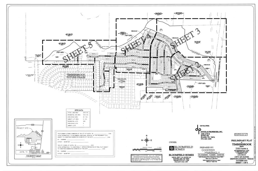
3 Planning & Zoning Meeting November 10, 2016 Justin City Hall, 415 North College Street City Council Cover Sheet Agenda Item: #1 Title: Timberbrook Zoning Department: Planning & Development Contact: Cori Reaume, Interim City Manager, Barry Hudson, Planning Consultant Background: Attached, please find a request for zoning for the Timberbrook Development. Timberbrook encompasses several large tracts of land currently in the City s city limits following recent annexation. When annexed into the City, the property automatically became zoned as SF-1. In the case of Timberbrook, the City did pass a development agreement. The terms of the agreement have more stringent zoning requirements than the SF-1 zoning. This zoning request by the developer is in line with the development agreement, (attached), which was passed by the City Council in April of this year. The request is for a planned development encompassing single family residential, commercial (along FM 407), a school site, a municipal site for a future police/fire station, a site for a water tower, many parks, and open space. The public hearing for this rezoning was opened and closed at the last Planning & Zoning meeting on October 18, The City Council s public hearing for this rezoning is scheduled for November 14, The Planning & Zoning Commission must take action on this item before the City Council will be allowed to hold the scheduled public hearing on November 14 th. Line Item: NA Amount remaining in line item: NA Expenditure Required: NA Additional Required: NA Budget Amendment Needed: NA City Attorney Review: No
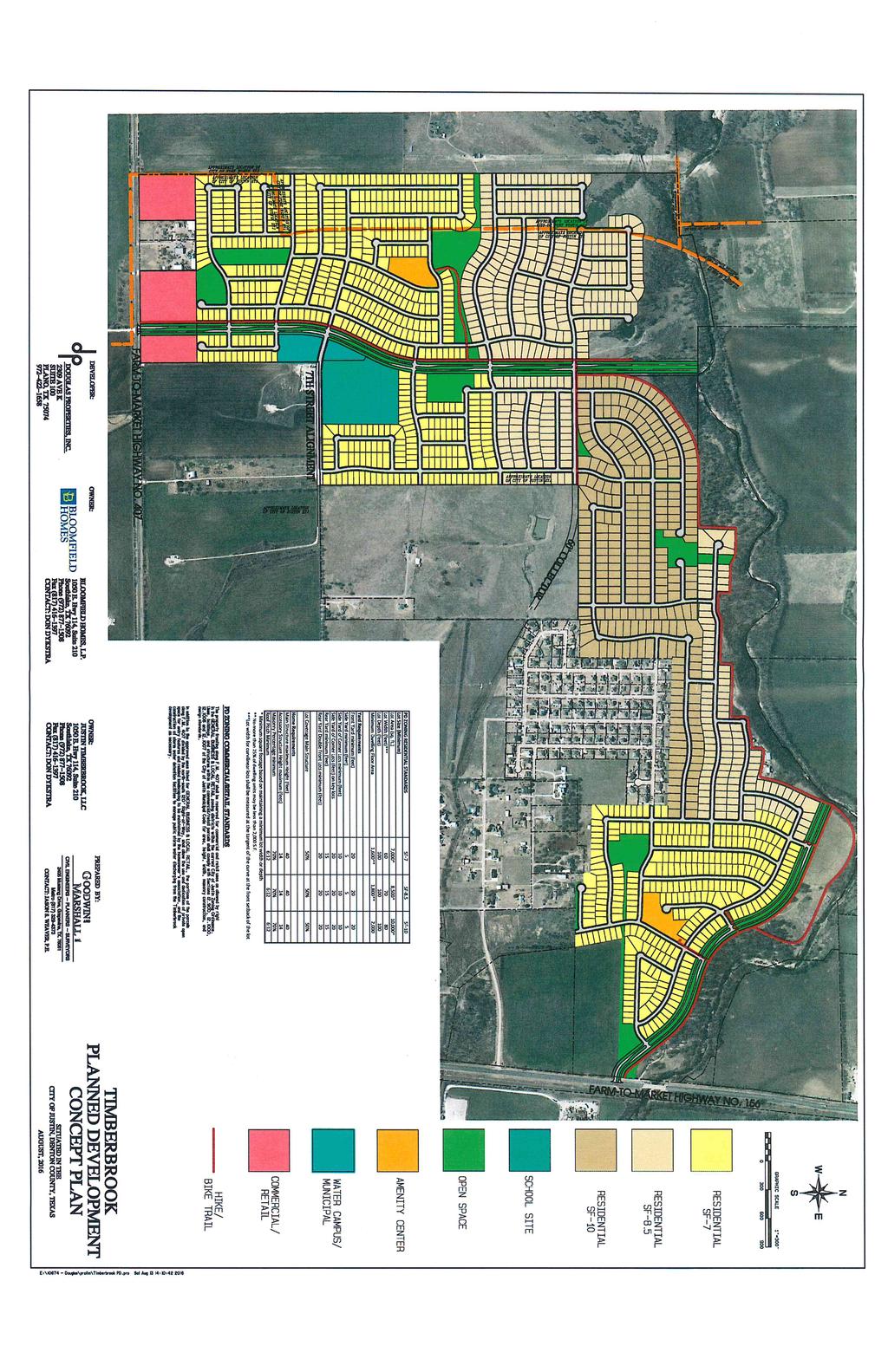
4 Recommendation: Recommend the requested zoning to the City Council. Attachments: (1) Timberbrook Development Agreement (2) Timberbrook Concept Plan (3) Timberbrook Zoning Application (4) Additional Timberbrook Information (5) Pending, to be sent later A review letter from Barry Hudson, Dunaway Associates regarding the requested zoning change.
5
6
7
8
9
10
11
12
13
14
15
16
17
18
19
20
21
22
23
24
25
26

27
28
29
30
31
32
33
34
35
36
37
38
39

40
41
42
43
44
45
46
47
48
49
50
51
52
53
54
55
56
57
58
59
60
61
62
63
64
65
66
67
68
69
70
71
72
73
74
75
76
77
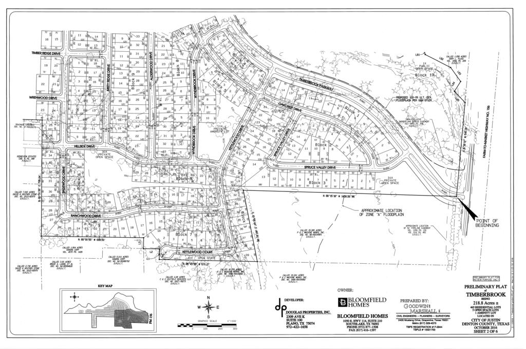
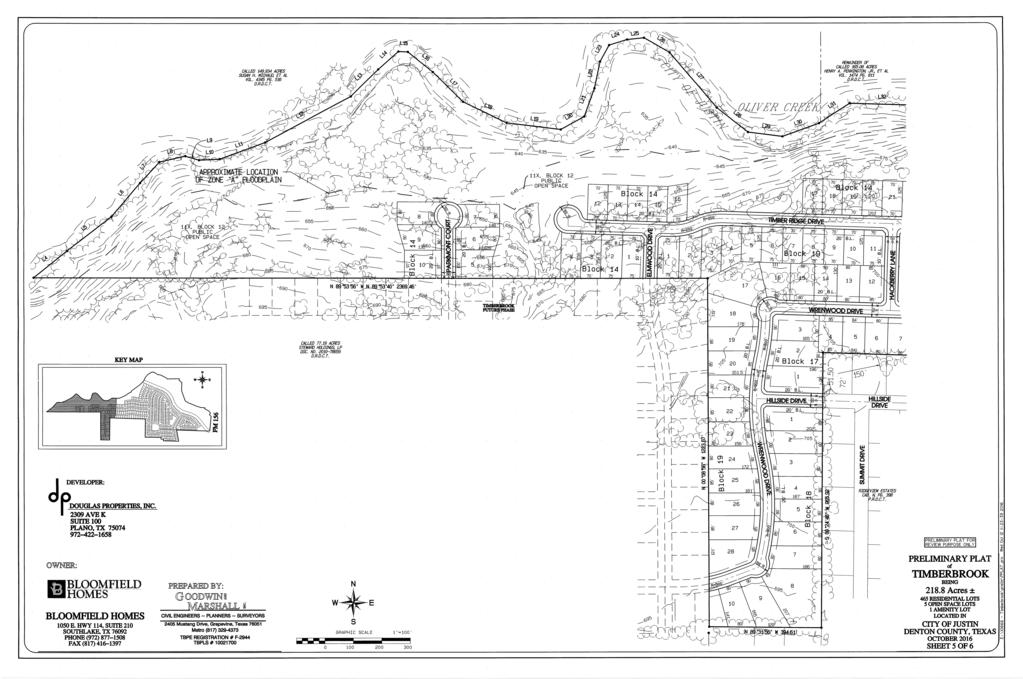
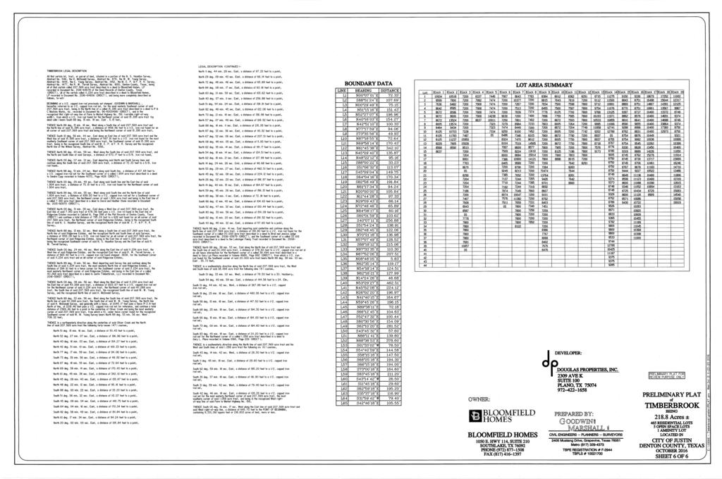
78 Planning & Zoning Meeting November 10, 2016 Justin City Hall, 415 North College Street City Council Cover Sheet Agenda Item: #2 Title: Timberbrook, Phase I Preliminary Plat Department: Planning & Development Contact: Cori Reaume, Interim City Manager; Gary Fisher, Engineering Consultant; Christopher Cha, Engineering Consultant; Barry Hudson, Planning Consultant Background: Attached, please find the preliminary plat submission for Phase I of the Timberbrook Development. This Development was approved by the City Council in April of this year and the plat submitted is in line with the concept plan approved at that time. Pacheco Koch has completed their review of the preliminary plat and I have included the engineering review letter in this packet. Line Item: NA Amount remaining in line item: NA Expenditure Required: NA Additional Required: NA Budget Amendment Needed: NA City Attorney Review: No Recommendation: Deny preliminary plat because it does not yet conform to subdivision regulations - See Engineering Review Letter Attachments: (1) Engineering review letter (2) Preliminary Plat for Timberbrook, Phase I (3) Preliminary Utilities & Drainage Study for Timberbrook, Phase I
79 November 7, 2016 PK No.: TX Reg. Engineering Firm F-469 Ms. Cori Reaume Interim City Manager City of Justin P.O. Box 129 Justin, Texas Re: CITY OF JUSTIN Timberbrook Subdivision Preliminary Plat Review Justin, Texas Dear Ms. Reaume: In accordance with your request October 26, 2016, the Preliminary Plat with attending preliminary drainage, water and sewer plans were reviewed against the Subdivision Regulations. The following comments are offered along with corresponding section in the Subdivision Regulations. Preliminary Plat 1. Provide layouts of the entire area intended to be subsequently subdivided showing tentative proposed layouts of streets, blocks, drainage, water, sewer and other improvements. Those in the executed Development Agreement we have are not readable. [26-101] 2. Provide a list of proposed restrictive covenants, conditions and limitations. [ AA] 3. Revise the City Certificates to delete the second dates for the minutes. [ II] 4. Revise the title of the signatory for the City Council to MAYOR. [ II] 5. Add a description for the basis of the bearings on the Preliminary Plat. [ G] 6. Add the name of the Registered Professional Land Surveyor responsible for preparing the Preliminary Plat. [ Z] 7. The limits of the existing drainage easement east of the northeast corner of Ridgeview Estates are unclear. [ D] 8. Show existing watercourses. [ D&FF] 9. Show building lines in Ridgeview Estates. [ D] 10. Present purpose or limitation of public and private open spaces. [ DD]
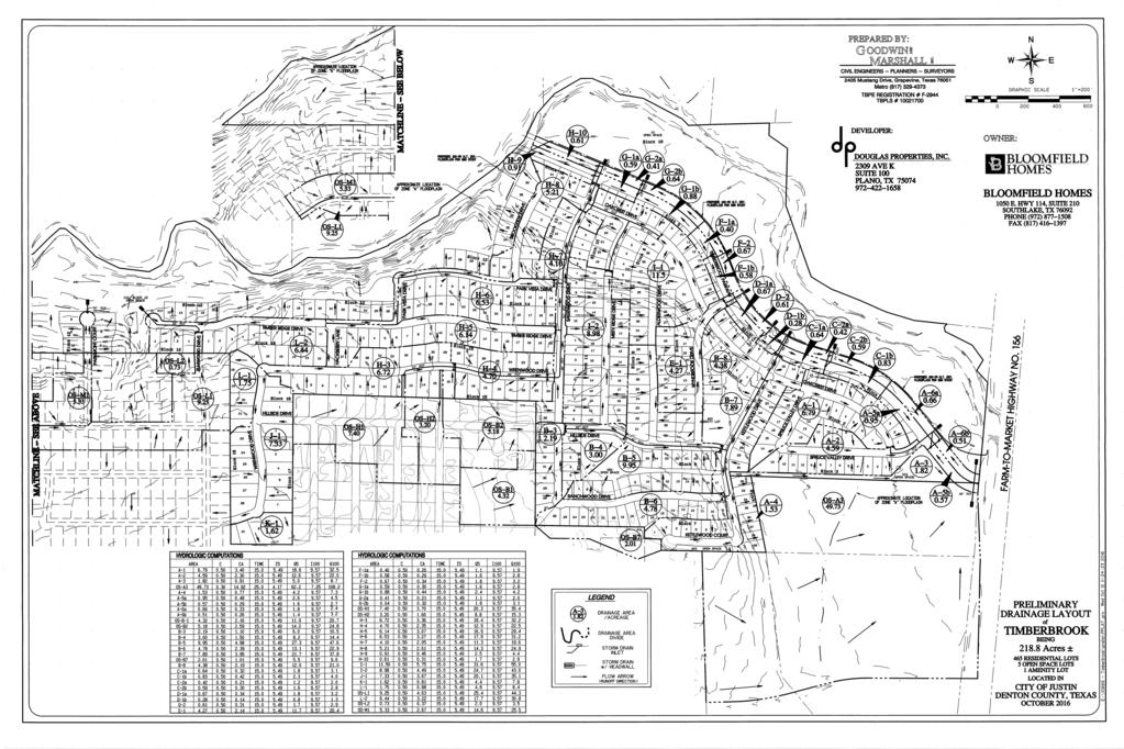
80 Ms. Cori Reaume November 7, 2016 Page Show the size, type and pressure of existing pipeline(s). [ Y] 12. Show existing gas well(s), site & pipeline easement(s). [ D,E&K] 13. Show limits of existing non-exclusive ingress and egress easement near FM 156. [ K] 14. Label approximate location of Zone A Floodplain limits on all applicable sheets. [ X] 15. Label all proposed streets on all sheets. [ M] 16. Show approximate outlines of all homes and other buildings and structures within and contiguous areas. [ K] 17. Provide paved access to Parkmont Ct. [45-100] & [45-102] 18. Consider projection of Kettlewood Drive right-of-way to the unsubdivided area to the south. [ C&D, C] 19. The residential street centerline radii should be revised to not less than 250 feet. [ E] 20. The Timberbrook Parkway centerline radii should be revised to not less than 1,200 feet. [ E] 21. It is recommended that the reversed curve of Timber Ridge Drive just east of Elmwood Drive be provided with a straight tangent section of not less than 100 feet between the curves. 22. At the Timberbrook Parkway intersection with FM 156, the centerline radius of Timberbrook Parkway (a thoroughfare) is 225 feet, far less than the minimum required of 1,200 feet. The City s Thoroughfare Plan show s this thoroughfare, if extended to the east, to have a grade separation (aka bridge) over FM 156 and the BNSF Railroad. It seems reasonable that there would be an at-grade, stop condition to FM 156. In view of this, it seems reasonable to allow a reduced speed section on the approach to FM 156. The reduced speed would allow a reduced centerline radius. If the speed limit were set to the residential speed of 30 miles per hour, the centerline radius could be a minimum of 250 feet. [ E] 23. Provide detail on the western terminus of Timberbrook Parkway. West of Sagewood Drive there is no turnaround or road closure shown. [26-104] Preliminary Drainage Layout 1. Drainage Areas A-1, A-4, B-4, B-5, I-6, H-6, and L-2 appear to have lot to lot drainage. [26-104] 2. Drainage Area K-1 appears to be draining through existing lots in Ridgeview Estates. Please provide more detail south of K-1 and the offsite area below that to show how runoff is to be handled. [26-104]
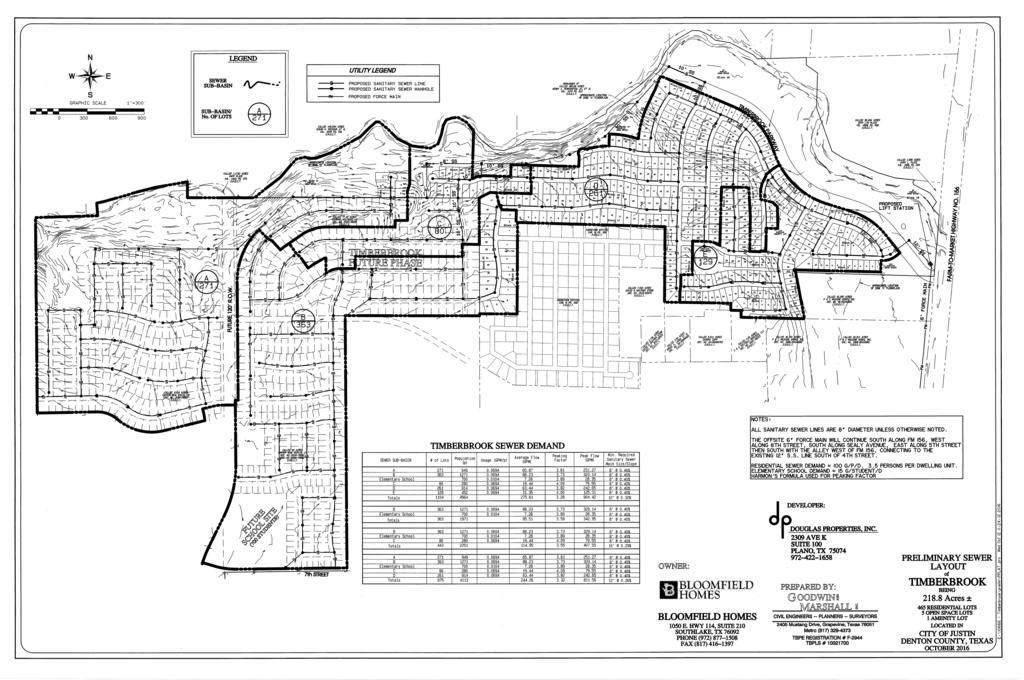
81 Ms. Cori Reaume November 7, 2016 Page 3 3. On topographical information, provide contour lines on a basis of five 5 foot intervals in terrain with a slope of five (5) or more and on a basis of two (2 ) foot intervals in terrain with a slope of less than five (5) percent. [26-104] 4. Provide more detail and contours on OS-A3, particularly the south side where contours look like there is a ditch (not ridge) which might capture more runoff. [26-104] 5. There are street and drainage improvements proposed outside of property without easements shown. [45-100] 6. The south portion of Drainage Area I-2 appears to flow south not north. [26-104] Preliminary Water Layout 1. Verify that east connection to Ridgeview Estates is a 12 WL as shown in Exhibit F of the Developer Agreement. [26-105] 2. Provide clarification on west side 12 loop, currently the Preliminary Water Layout does not show a 12 loop for the subdivision. Ridgeview Estates is connected to water tower via 6 water lines. There is still an ongoing investigation into whether the 12 line on the west side is needed at this phase. [53-101] Preliminary Sewer Layout 1. Based on the contours shown, sewer depths in Sewer Sub-Basin B and Sewer Sub-Basin E look excessive and too deep to be access within a 50 or 60 ROW. Areas of note are along Oakcrest Drive and on the north/south road near the north part of Sewer Sub-Basin B. [53-101] 2. Exhibit F of the developer agreement provides a sanitary sewer line along Timberbrook Parkway. The preliminary sewer layout does not provide a sanitary sewer line along Timberbrook Parkway but is proposed down Oakcrest Drive. The sanitary sewer line along Timberbrook Parkway allows for additional space for access in the future particularly on the given the apparent depth of the 12 sanitary sewer main on Oakcrest Drive. Should you have any questions about the information contained herein, please do not hesitate to call. Sincerely, {ORIGINAL SIGNED BY CHRIS CHA} Chris Cha, P.E. {ORIGINAL SIGNED BY GARY W. FISHER} Gary W. Fisher, P.E.
82
83
84
85
86
87
88
89
90
SUBDIVISION APPLICATION
 SUBDIVISION APPLICATION Preliminary Plat Minor Plat Final Plat Amended Plat Applicant Name: Owner (if different from applicant) Name: Company: Company: Address: Address: City, State, Zip City, State, Zip
APPLICATION FOR PRELIMINARY PLAT CERRO GORDO COUNTY, IOWA
 APPLICATION FOR PRELIMINARY PLAT CERRO GORDO COUNTY, IOWA Before subdividing any tract of land and previous to the filing of an Application for conditional approval of the Preliminary Plat, the subdivider
BRIDGETON SUBDIVISION APPLICATION CHECKLIST
 APPLICATION NAME AND # CHECKLIST COMPLETED BY: DATE: Signature and printed name BRIDGETON SUBDIVISION APPLICATION CHECKLIST TO SUBDIVISION APPLICANTS: The attached checklist is to assist you in the submission
PRELIMINARY PLATS. The following documents are provided as required by the City of Conroe for use in the above titled platting submittals:
 Public Works Engineering Division CITY OF CONROE PRELIMINARY PLATS The following documents are provided as required by the City of Conroe for use in the above titled platting submittals: Submittal Questionnaire
TOWN OF ROXBURY PLANNING BOARD
 UPDATED: APRIL 2011 TOWN OF ROXBURY PLANNING BOARD Applicant s Guide for Subdivision Review The Town Planning Board administers the subdivision review process. This guide has been prepared in order to
New Electronic Planning Commission Submittal Process
 New Electronic Planning Commission Submittal Process STANDARD OPERATING PROCEDURE Purpose: To outline the electronic submittal process for applications to the Planning Commission. Background: Procedure:
APPLICATION SUBMITTAL REQUIREMENTS FOR Tentative Parcel or Subdivision Maps
 CITY OF EL CERRITO Community Development Department Planning and Building Division 10890 San Pablo Avenue, El Cerrito, CA 94530 (510) 215-4330 FA (510) 233-5401 planning@ci.el-cerrito.ca.us APPLICATION
Township of Little Egg Harbor Planning Board 665 Radio Road Little Egg Harbor, New Jersey Phone: ext. 221 Fax:
 BLOCK(S) LOT(S) Township of Little Egg Harbor Planning Board 665 Radio Road Little Egg Harbor, New Jersey 08087 Phone: 609-296-7241 ext. 221 Fax: 609-294-3040 Development Application Amended Development
E L M E R B O R O U G H L A N D U S E B O A R D APPLICATION COVER SHEET (to be completed for all applications and appeals)
") E L M E R B O R O U G H L A N D U S E B O A R D APPLICATION COVER SHEET (to be completed for all applications and appeals) 1. Name(s): 2. Address: 3. Telephone Number(s): 4. E-mail: 5. Owner Name(s) (if
E L M E R B O R O U G H L A N D U S E B O A R D APPLICATION COVER SHEET (to be completed for all applications and appeals) 1. Name(s): 2. Address: 3. Telephone Number(s): 4. E-mail: 5. Owner Name(s) (if
PLANNING COMMISSION SUBDIVISION PLAT APPLICATION
 PLANNING COMMISSION SUBDIVISION PLAT APPLICATION Economic Development Department 3468 North Fulton Avenue Hapeville, Georgia 30354 Phone - 404.669.8269 Fax 404.669.3302 Rev. 09/23/16 1 The following information
City of Suwanee Development Regulations ARTICLE 10 PLAN AND PLAT SPECIFICATIONS
 ARTICLE 10 PLAN AND PLAT SPECIFICATIONS 10.1 CONCEPT PLAN SPECIFICATIONS The following paragraphs outline the required elements of both the required and optional plans and plats mentioned throughout these
ARTICLE V. PRELIMINARY PLAT
 ARTICLE V. PRELIMINARY PLAT PAGE 13 SECTION A. PURPOSE. The purpose of the preliminary plat is to allow the Planning and Zoning Commission to review overall platting of the tract and street patterns within
FINAL SUBDIVISION AND LAND DEVELOPMENT PLAN CHECKLIST. Plan Name. Applicant's Name:
 TOWNSHIP OF UPPER ST. CLAIR FINAL SUBDIVISION AND LAND DEVELOPMENT PLAN CHECKLIST Date Filed Plan Name PLC Applicant's Name: Phone Filing Date for Final Application Final Plat 114.22. FINAL APPLICATION
Subdivision - Minor Plat Submittal
 Subdivision - Minor Plat Submittal This Checklist is intended to provide the information and data that is necessary to assess the merits of the project proposal. Please note that this Checklist is intended
TOWN OF LEWISTON PLANNING BOARD APPLICATION
 TOWN OF LEWISTON PLANNING BOARD APPLICATION DESCRIPTION OF PROPOSED REQUEST: Name of Property Owner: Phone #: Name of Applicant:Phone #: Address or Location of Proposal:_SBL# Size of Parcel or Structure:Existing
SECTION 6 - APPROVAL OF PLATS. Whenever any subdivision of land is proposed, and before any permit for the
 SECTION 6 - APPROVAL OF PLATS 6-1 APPROVAL REQUIRED BEFORE SALE Whenever any subdivision of land is proposed, and before any permit for the erection of a structure shall be granted, the subdivider or his
City of Sanibel. Planning Department STAFF REPORT
 City of Sanibel Planning Department STAFF REPORT Planning Commission Meeting: July 23, 2013 Planning Commission Agenda Item: No 7b. Application Number: 13-7438DP Applicant Name: Attorney Beverly Grady
APPLICATION FOR MAJOR SUBDIVISION APPROVAL (PRELIMINARY PLAT)
") 209 S. Main Street Marysville, Ohio 43040 Phone: (937) 645-7350 Fax: (937) 645-7351 www.marysvilleohio.org APPLICATION FOR MAJOR SUBDIVISION APPROVAL (PRELIMINARY PLAT) *** IMPORTANT INFORMATION ~ Please
209 S. Main Street Marysville, Ohio 43040 Phone: (937) 645-7350 Fax: (937) 645-7351 www.marysvilleohio.org APPLICATION FOR MAJOR SUBDIVISION APPROVAL (PRELIMINARY PLAT) *** IMPORTANT INFORMATION ~ Please
FINAL PLAT APPLICATION
 FINAL PLAT APPLICATION (Page 1 of 3) LEGAL OWNER(s): NAME: STREET ADDRESS OWNER(s): CITY, STATE, ZIP CODE: PHONE NUMBER: BILLING ADDRESS: NAME OF ENGINEER/SURVEYOR: Engineer/Surveyor Address, Phone: PROPERTY
APPLICATION for MINOR SUBDIVISION REVIEW for CONCEPT and FINAL PLAT within COALVILLE CITY. Project Name: Project Address or Area: Name of Owner:
 APPLICATION for MINOR SUBDIVISION REVIEW for CONCEPT and FINAL PLAT within COALVILLE CITY For Office Use Only: Application #: Application Date: PC Approval Date: CC Approval Date: Community Development
THE COUNTY BOARD OF SUPERVISORS OF THE COUNTY OF DOUGLAS DOES ORDAIN AS FOLLOWS:
 8.1 SUBDIVISION CONTROL ORDINANCE THE COUNTY BOARD OF SUPERVISORS OF THE COUNTY OF DOUGLAS DOES ORDAIN AS FOLLOWS: SECTION I. GENERAL INTERPRETATION This ordinance shall not repeal, impair or modify private
CHAPTER SUBDIVISION MAPS
 CHAPTER 19.66 SUBDIVISION MAPS SUBDIVISION MAPS 19.66 Section Page 19.66.010 Purpose... IV-56 19.66.020 Application... IV-57 19.66.030 Exclusions... IV-57 19.66.040 Effect of Annexation... IV-57 19.66.050
Initial Subdivision Applications Shall Include the Following:
 Initial Subdivision Applications Shall Include the Following: 1) Subdivision Application Form: completely filled out (12 copies) 2) Plat: The Plat must adhere to the requirements set forth in the Town
Preliminary Plat & Layout Plan Submittal Guidelines
 Preliminary Plat & Layout Plan Submittal Guidelines PRELIMINARY PLAT & LAYOUT PLANS is typically the first step in the platting process. The purpose of the PRELIMINARY PLAT & LAYOUT PLANS is for the Applicant
LABEL PLEASE NOTE: ALL APPLICATIONS AND SITE PLANS MUST BE COMPLETED IN BLACK OR BLUE INK ONLY Intake by:
 STAFF USE ONLY Thurston County Resource Stewardship 2000 Lakeridge Dr. S.W. Olympia, WA 98502 (360)786-5490 / (360)754-2939 (Fax) TDD Line (360) 754-2933 Email: permit@co.thurston.wa.us Supplemental Application
Gates County Planning and Zoning
 Gates County Planning and Zoning PO Box 411, 200 Court Street, Gatesville, NC 27938 phone: 252-357-2411 fax: 252-357-0073 Application for Technical Review Committee For Staff Use Only: Date: Application
PRELMINARY PLAT CHECKLIST
 PRELMINARY PLAT CHECKLIST A. All preliminary plat submitted for approval shall be prepared by a Registered Professional Land Surveyor. B. Preliminary plats must be drawn to a scale of XXX with such accuracy
SUBDIVISION APPLICATION CHECKLIST SKETCH PLAN PRELIMINARY PLAT FINAL PLAT
 RECEIVED STAMP SUBDIVISION APPLICATION CHECKLIST SKETCH PLAN PRELIMINARY PLAT FINAL PLAT A checklist of background information and submission requirements for processing of a sketch plan, preliminary plat
MINOR PLAT. The following documents are provided as required by the City of Conroe for use in the above titled platting submittals:
 Public Works - Engineering Division CITY OF CONROE MINOR PLAT The following documents are provided as required by the City of Conroe for use in the above titled platting submittals: Submittal Questionnaire
SUBDIVISION PLAT CHECKLIST. The following information shall be include on the plat:
 SUBDIVISION PLAT CHECKLIST Subdivision Name: Land Surveyor: Owner/Developer: Date Submitted: The following information shall be include on the plat: The plat shall be drawn at a scale of one inch equals
ELMORE COUNTY LAND USE & BUILDING DEPARTMENT 520 E 2 nd South Mountain Home, ID (208) Preliminary Plat Application
 Preliminary Plat Application") ELMORE COUNTY LAND USE & BUILDING DEPARTMENT 520 E 2 nd South Mountain Home, ID 83647 (208) 587-2142 www.elmorecounty.org Preliminary Plat Application We are unable to accept facsimile copies. (Subdivisions
ELMORE COUNTY LAND USE & BUILDING DEPARTMENT 520 E 2 nd South Mountain Home, ID 83647 (208) 587-2142 www.elmorecounty.org Preliminary Plat Application We are unable to accept facsimile copies. (Subdivisions
C O M M U N I T Y D E VELOPMENT S E R VICES PLEASE CHECK ALL THAT APPLY
 LAND USE MASTER INVOICE C O M M U N I T Y D E VELOPMENT S E R VICES 435 MARTIN STREET, STE. 3000 BLAINE, WA 98230 PHONE: (360) 332-8311 FAX: (360) 543-9978 Total Fees $ FOR OFFICIAL USE ONLY I, the applicant/owner,
R/W PREQUALIFICATION ODOT, 3/14/2018
 R/W PREQUALIFICATION ODOT, 3/14/2018 BRETT SHEARER, C.O. REAL ESTATE PROPOSED RIGHT OF WAY DESIGN 172 PROPOSED RIGHT OF WAY DESIGN PROPOSED RIGHT OF WAY DESIGN Section 3200 Types of Title 173 PROPOSED
610 LAND DIVISIONS AND PROPERTY LINE ADJUSTMENTS OUTSIDE A UGB
 ARTICLE VI: LAND DIVISIONS AND PROPERTY LINE ADJUSTMENTS VI-21 610 LAND DIVISIONS AND PROPERTY LINE ADJUSTMENTS OUTSIDE A UGB 610-1 Property Line Adjustments (Property Line Relocation) A property line
APPLICATION FOR PRELIMINARY PLAT RESIDENTAIL. FILING FEE: $ for the first 20 lots; $10.00 for each additional lot over 20
 COMMUNITY PLANNING & DEVELOPMENT TELEPHONE.* (816) 331-4331 FAX * (816) 331-6973 CITY HALL ANNEX 520 MAIN STREET BELTON, MISSOURI 64012 WEBSITE * www.belton.org APPLICATION FOR PRELIMINARY PLAT RESIDENTAIL
A GUIDE TO PROCEDURES FOR: SUBDIVISIONS & CONDOMINIUM CONVERSION
 A GUIDE TO PROCEDURES FOR: SUBDIVISIONS & CONDOMINIUM CONVERSION A GUIDE TO PROCEDURES FOR: SUBDIVISIONS (TENTATIVE MAPS) PURPOSE Definition: A subdivision is defined as the division of any improved or
PLYMOUTH PLANNING BOARD APPLICATION FOR A MINOR SUBDIVISION OR MAJOR SUBDIVISION
 CASE # PLYMOUTH PLANNING BOARD APPLICATION FOR A MINOR SUBDIVISION OR MAJOR SUBDIVISION The undersigned Applicant hereby submits to the Plymouth Planning Board a completed application for a proposed minor
APPLICATION PROCEDURE
 ANTRIM PLANNING BOARD P. O. Box 517 Antrim, New Hampshire 03440 Phone: 603-588-6785 FAX: 603-588-2969 APPLICATION FORM AND CHECKLIST FOR MINOR OR MAJOR SITE PLAN REVIEW File Date Received By APPLICATION
MUDDY CREEK TOWNSHIP PO BOX 239 PORTERSVILLE, PA SUBDIVISION AND LAND DEVELOPMENT APPLICATION
 MUDDY CREEK TOWNSHIP PO BOX 239 PORTERSVILLE, PA 16051 724-368-3438 SUBDIVISION AND LAND DEVELOPMENT APPLICATION NOTE TO ALL APPLICANTS: This checklist must be completed in its entirety If an item is not
SUBDIVISION AND LAND DEVELOPMENT. 185 Attachment 20
 185 Attachment 20 APPENDIX S Plat No. Date of Submission Twp. Fee $ Dauphin Co. Fee $ TOWNSHIP OF DERRY SUBDIVISION OR LAND DEVELOPMENT PLAN SUBMISSION APPLICATION This block for Twp. use only 1. Title
Section Preliminary Plat Checklist and Application Forms
 Section 201 - Preliminary Plat Checklist and Application Forms PRELIMINARY SUBDIVISION PLAT REVIEW PROCESS CHART PRELIMINARY SUBDIVISION PLAT APPLICATION PRELIMINARY PLAT REVIEW CHECKLIST CITY OF NAMPA
CITY OF DECATUR, TEXAS
 Final Plat or Amending Plat / Replat Checklist A submittal of a complete application will facilitate a timely review. Failure of the applicant to provide required information or obtain a waiver from the
CHAPTER 3 PRELIMINARY PLAT
 10-3-1 10-3-3 SECTION: CHAPTER 3 PRELIMINARY PLAT 10-3-1: Consultation 10-3-2: Filing 10-3-3: Requirements 10-3-4: Approval 10-3-5: Time Limitation 10-3-6: Grading Limitation 10-3-1: CONSULTATION: Each
Township of Collier 2418 Hilltop Road Presto, PA 15142
 Township of Collier 2418 Hilltop Road Presto, PA 15142 Fees: Major: 2 checks $600 + $50 per lot & $1700 Escrow) APPLICATION FOR SUBDIVISION major FINAL only Plans must be folded Rolled plans will not be
Chapter 22 LAND USE* Article III. Subdivisions
 Chapter 22 LAND USE* Article III. Subdivisions Sec. 22-256. Authority to Regulate. Sec. 22-257. Scope; plat required. Sec. 22-258. Definitions. Sec. 22-259. Interpretations and Meanings. Sec. 22-260. Procedure
Preliminary Subdivision Application (Major) (Four (4) lots or more)
 (Four (4) lots or more)") Gunnison City Offices www.gunnisoncity.org 38 West Center Gunnison, Utah 84634 (435) 528 7969 Date of Application: Preliminary Subdivision Application (Major) (Four (4) lots or more) APPLICANT INFORMATION
Gunnison City Offices www.gunnisoncity.org 38 West Center Gunnison, Utah 84634 (435) 528 7969 Date of Application: Preliminary Subdivision Application (Major) (Four (4) lots or more) APPLICANT INFORMATION
ARTICLE 900 PLAT AND PLAN REQUIREMENTS
 ARTICLE 900 PLAT AND PLAN REQUIREMENTS SEC. 900.1 ITEMS TO BE SHOWN ON PLAT OR PLAN General (1) Property lines of all property owners adjacent to the exterior boundaries of the project shall be located
APPLICATION FOR 555 Washington Street Tentative Map Red Bluff, CA Subdivision Map (530) ext Parcel Map.
 ext Parcel Map.") City of Red Bluff Community Development Department Application No. APPLICATION FOR 555 Washington Street Tentative Map Red Bluff, CA 96080 Subdivision Map (530) 527-2605 ext. 3059 Parcel Map Applicant
City of Red Bluff Community Development Department Application No. APPLICATION FOR 555 Washington Street Tentative Map Red Bluff, CA 96080 Subdivision Map (530) 527-2605 ext. 3059 Parcel Map Applicant
DIVISION 2 - CONSTRUCTION PLAN AND MISCELLANEOUS REQUIREMENTS
 DIVISION 2 - CONSTRUCTION PLAN AND MISCELLANEOUS REQUIREMENTS 2.1 Required Plan Sheets 2.2 Drawing Requirements 2.3 Graphic Standards 2.4 Easements 2.5 Utility Locations 2.6 Private Facility Locations
MAJOR SUBDIVISION PRELIMINARY PLAT CHECKLIST
 TOWNSHIP OF EGG HARBOR PLANNING BOARD/ZONING BOARD OF ADJUSTMENT 3515 BARGAINTOWN ROAD EGG HARBOR TOWNSHIP, NJ 08234 MAJOR SUBDIVISION PRELIMINARY PLAT CHECKLIST The following checklist is designed to
Applicant: Address: Fee Owner: Address: Property Location (Address and Complete (long) Legal Description: Detailed Reason for Request:
 Legal Description: Detailed Reason for Request:") Date Received: Received By: Permit #: LAND USE APPLICATION Comprehensive Plan Zoning District Amend Zoning Text Amend Variance*(see below) Zoning Appeal Conditional Use Permit (C.U.P.) Flood Plain C.U.P.
Date Received: Received By: Permit #: LAND USE APPLICATION Comprehensive Plan Zoning District Amend Zoning Text Amend Variance*(see below) Zoning Appeal Conditional Use Permit (C.U.P.) Flood Plain C.U.P.
RIVERDALE CITY PLANNING COMMISSION APPLICATION FOR RESIDENTIAL SUBDIVISION SITE PLAN APPROVAL
 Community Development 4600 So. Weber River Drive Riverdale, Utah 84405 RIVERDALE CITY PLANNING COMMISSION APPLICATION FOR RESIDENTIAL SUBDIVISION SITE PLAN APPROVAL CASE NO: DATE SUBMITTED: APPLICANT S
Oakland County Michigan Register of Deeds Plat Engineering, GIS, & Remonumentation Dept. Ph: (248) Fax (248)
 Fax (248)") Oakland County Michigan Register of Deeds Plat Engineering, GIS, & Remonumentation Dept. Ph: (248)-858-1447 Fax (248)-858-7466 Requirements Needed for Final Plat Approval No. General Requirements. 1 Routing
Oakland County Michigan Register of Deeds Plat Engineering, GIS, & Remonumentation Dept. Ph: (248)-858-1447 Fax (248)-858-7466 Requirements Needed for Final Plat Approval No. General Requirements. 1 Routing
Application for Subdivision and Land Development
 Application for Subdivision and Land Development Montgomery Township 1001 Stump Road Montgomeryville, PA 18936-9605 Telephone: 215-393-6920 Fax: 215-855-1498 www.montgomerytwp.org 9-2017 TO: FROM: RE:
BOSSIER CITY PARISH METROPOLITAN PLANNING COMMISSION 620 Benton Rd. Bossier City, LA Phone: Fax: PRELIMINARY PLAT
 (OFFICE USE ONLY) Application Fee: Paid: Date: CASE # Project Information BOSSIER CITY PARISH METROPOLITAN PLANNING COMMISSION 620 Benton Rd. Bossier City, LA 71111 Phone: 318-741-8824 Fax: 318-741-8827
TOWN OF NORTHWOOD, NEW HAMPSHIRE
 TOWN OF NORTHWOOD, NEW HAMPSHIRE OFFICE OF THE PLANNING BOARD 818 First New Hampshire Turnpike, Northwood NH 03261 (603)942-5586 Extension 205 Facsimile: (603)942-9107 Major Subdivision Application Form
CHAPTER FINAL AND PARCEL MAPS
 CHAPTER 19.48 FINAL AND PARCEL MAPS Section Page 19.48.010 General... IV-25 19.48.020 Phasing... IV-25 19.48.030 Survey Required... IV-26 19.49.040 Form... IV-26 19.48.050 Contents... IV-27 19.48.060 Preliminary
Tentative Map Application Review Procedures
 FOR REFERENCE ONLY This page is not part of the application. Tentative Map Application Review Procedures The tentative map process in Churchill County is designed to provide a mechanism in order to divide
New Private Way Ordinance Westbrook Planning Board Workshop , Planning Board Public Hearing Definitions
 201 Definitions Private Right of Way; Private way A strip of land at least fifty feet wide, meeting the minimum standards for the construction of a gravel base for a public road, over which abutters may
Conditional Use Permit / Standard Subdivision Application
 Conditional Use Permit / Standard Subdivision Application Name of Proposed Subdivision: Total Area (Acres) Is Proposed Subdivision to be built in phases? Number of Lots If yes, how many phases? Applicant/Owner
SUBDIVISION REGULATIONS ORDINANCE NO
 SUBDIVISION REGULATIONS OF THE CITY OF HAMILTON, OHIO ORDINANCE NO. 6038 1 ADOPTED FEBRUARY 4, 1959 REVISED THROUGH JANUARY 11, 2014 1 The Subdivision Regulations of the City of Hamilton became a part
DEVELOPMENT PROCEDURES MANUAL
 DEVELOPMENT PROCEDURES MANUAL City of Siloam Springs Community Services Department Planning Division 400 N. Broadway St./P.O. Box 80 Siloam Springs, AR 72761 Phone: (479) 524 5136 www.siloamsprings.com
HERON LANDING SUBDIVISION
 HERON LANDING SUBDIVISION Engineering Comments: Per FEMA guidelines, any development greater than 5 acres in size or subdivision 50 lots in size, requires a flood study. Width of drainage easement to be
City of Duluth Development Regulations
 ARTICLE 10 PLAN AND PLAT SPECIFICATIONS 10.1 CONCEPT PLAN SPECIFICATIONS The following paragraphs outline the required elements of both the required and optional plans and plats mentioned throughout these
CITY OF STRONGSVILLE PLANNING COMMISSION APPLICATION SINGLE FAMILY SUBDIVISION
 CITY OF STRONGSVILLE PLANNING COMMISSION APPLICATION SINGLE FAMILY SUBDIVISION After meeting with City Planner, George Smerigan (if necessary) regarding zoning requirements, submit the following: Pursuant
Administrative Plat Application Form
 1 Administrative Plat Application Form This form shall be submitted with each application for an administrative plat. CONTACT INFORMATION Applicant Architect (if different) Property Owner (if different)
MAPLETON CITY CORPORATION. Step 7: Upon final approval and prior to plat recording the applicant shall provide the following:
 MAPLETON CITY CORPORATION Subdivision Process The City s subdivision requirements are designed to facilitate orderly, safe and efficient development and to implement the adopted General Plan. Below is
CITY OF GROVER BEACH COMMUNITY DEVELOPMENT DEPARTMENT Tentative Map Checklist
 CITY OF GROVER BEACH COMMUNITY DEVELOPMENT DEPARTMENT Tentative Map Checklist The following list includes all of the items you must submit for a complete application. Some specific types of information
PLANNING BOARD CITY OF CONCORD, NH MINOR SUBDIVISION CHECKLIST
 PLANNING BOARD CITY OF CONCORD, NH MINOR SUBDIVISION CHECKLIST Summary This checklist is intended to assist applicants and design professionals in the preparation of minor subdivision applications for
City of Prior Lake APPLICATION FOR COMBINED PRELIMINARY AND FINAL PLAT
 Case File No. Property Identification No. City of Prior Lake APPLICATION FOR COMBINED PRELIMINARY AND FINAL PLAT Requested Action Brief description of proposed project (Please describe the proposed amendment,
To provide for the review of the final engineering plans, the subdivision improvement agreement, public dedications, and other legal agreements.
 ARTICLE 5 FINAL PLAT 501 Intent DOUGLAS COUNTY SUBDIVISION RESOLUTION To provide for the review of the final engineering plans, the subdivision improvement agreement, public dedications, and other legal
Use permitted by: Right Special Exemption
 CENTER TOWNSHIP 150 Henricks Road Butler, PA 16001-8472 Phone (724) 282-7805 Fax (724) 282-6550 Application Number: FEE COLLECTED: Application for: Preliminary Final Land Development Location: Map and
Appendix A: Submittal Checklists
 Appendix A: Submittal Checklists A.1 Preliminary Plat Checklist A.2 Final Plat Checklist 11 Appendix A.1 DESIGN CHECKLIST FOR PRELIMINARY PLATS AND DEVELOPMENTS Development Name: Location: Date: Reviewed
EDGERTON CITY HALL PLANNING COMMISSION MEETING REGULAR SESSION March 12, 2019
 EDGERTON CITY HALL PLANNING COMMISSION MEETING REGULAR SESSION The met in regular session with Chair John Daley calling the meeting to order at 7:00 p.m. All present participated in the Pledge of Allegiance.
LAND USE APPLICATION
 LAND USE APPLICATION File Name: File No(s).: Receipt No.: Receipt Date: Received By: Amount.: $ Instructions for Applicants Please read and follow all instructions on your application carefully. If you
I. Requirements for All Applications. C D W
 108-16.1. Application checklists. Checklist for Required Submissions to the Planning Board or Zoning Board of Adjustment of Monroe Township All required submissions are to be made to the Administrative
CITY OF HOBBS ORDINANCE NO..
 CITY OF HOBBS ORDINANCE NO.. AN ORDINANCE TO AMEND TITLE 16 OF THE HOBBS MUNICIPAL CODE IN ITS ENTIRETY. BE IT ORDAINED BY THE GOVERNING BODY OF THE CITY OF HOBBS, NEW MEXICO, that the following Chapter
PRELIMINARY SUBDIVISION AND LAND DEVELOPMENT PLAN CHECKLIST. Applicant's Name:
 TOWNSHIP OF UPPER ST. CLAIR PRELIMINARY SUBDIVISION AND LAND DEVELOPMENT PLAN CHECKLIST Date Filed Plan Name: Applicant's Name: PLC# Phone = OK 0 = Missing; X = Not OK; NA = Not Applicable;? To be Determined;
TOWN OF LERAY PLANNING BOARD Minor Subdivision Application Packet
 This Packet is designed to assist applicants in providing the forms needed for submission of a 1 to 4 lot subdivision to the Planning Board for approval. The following should be filled out to ensure the
SPANISH FORT PLANNING COMMISSION PRELIMINARY SUBDIVISION PLAT APPLICATION. Number of Lots (Units) Address. Address.
 Address. Address.") Case No. SPANISH FORT PLANNING COMMISSION PRELIMINARY SUBDIVISION PLAT APPLICATION Name of Subdivision Tax Parcel Number(s) Subdivision Location Total Acreage Number of Lots (Units) Average Lot Size Current
Case No. SPANISH FORT PLANNING COMMISSION PRELIMINARY SUBDIVISION PLAT APPLICATION Name of Subdivision Tax Parcel Number(s) Subdivision Location Total Acreage Number of Lots (Units) Average Lot Size Current
Planning Commission Review ZONING ANNEXATION SUBDIVISION STREET NAMING
 Planning Commission Review ZONING ANNEXATION SUBDIVISION STREET NAMING I. Requested Action Zoning Change Annexation Street Naming/Renaming Preliminary Subdivision Approval General Subdivision Approval
JEFFERSON COUNTY, ALABAMA
 JEFFERSON COUNTY, ALABAMA Major Development Checklist, Notes and Information A Major Development is any proposed new structure or addition to an existing structure which will cause a change in the topography
City of Yelm. Community Development Department BOUNDARY LINE ADJUSTMENT OR LARGE LOT SUBDIVISION
 City of Yelm Community Development Department BOUNDARY LINE ADJUSTMENT OR LARGE LOT SUBDIVISION Fee Date Received By File No. FEES: Boundary Line Adjustment $100.00 LARGE LOT SUBDIVISION $250.00, + $10.00/lot
Conditional Use Sketch Plan Application Non-Residential Zone
 For Office Use Only Fees received by: Date of submittal: Amount Paid: Receipt #: Initial Review, all of the required supporting materials have been provided: Sketch Plan Meeting Date: Conditional Use Sketch
SUBDIVISION APPLICATION
 STAFF USE ONLY Date Submitted: Received by: Fee paid: Project # REQUIRED SUBMITTALS Application Fee: $600.00 (up to 5 lots) + $50.00 (per lot above 5) Publication Fee: $300.00 Mailing Fee: $6.00 per hearing
CITY OF STRONGSVILLE PLANNING COMMISSION APPLICATION CLUSTER SUBDIVISION
 CITY OF STRONGSVILLE PLANNING COMMISSION APPLICATION CLUSTER SUBDIVISION After meeting with City Planner, George Smerigan (if necessary) regarding zoning requirements, submit the following: An application
A Final Plat will be reviewed concurrently with any other development review application(s) that is required.
 that is required.") RELATED FACTS TO KNOW: Adams County Recording Requirements, Annexation, Common Wall Subdivision, Development Plan (PUD Development Permit), Fees, Helpful Contact Information, Lot Line Adjustment, Neighborhood
RELATED FACTS TO KNOW: Adams County Recording Requirements, Annexation, Common Wall Subdivision, Development Plan (PUD Development Permit), Fees, Helpful Contact Information, Lot Line Adjustment, Neighborhood
Memorandum: October 13, 2008 REVISED To: Trowbridge Township Planning Commission From: P. Hudson, AICP Re: Suggested New Ordinance
 1 Memorandum: October 13, 2008 REVISED 2-11-09 To: Trowbridge Township Planning Commission From: P. Hudson, AICP Re: Suggested New Ordinance Because of changes in both the Michigan Planning Enabling Act
Department of Planning & Development Services
 Department of Planning & Development Services S T A F F R E P O R T February 9, 2015 CASE NO: PROJECT: EXECUTIVE SUMMARY: ZA14-154 Plat Revision for Lots 25R-1A, 25R-1B and 25R-1C, Block 1, Woodland Heights
Plat Checklist PLAT TYPES AND DESCRIPTIONS
 Master Plan / Revision to Master Plan (For Platting Purposes Only) Preliminary/Final Plat Preliminary Plat Final Plat Minor Plat Replat Amended Plat Plat Checklist So that we may efficiently review your
-MENDOCINO COUNTY PLANNING AND BUILDING SERVICES- DIVISION OF LAND REGULATIONS TITLE 17
 ARTICLE VI -- GENERAL REGULATIONS AND PROVISIONS Sec. 17-50. Sec. 17-51 General Plan. Sec. 17-52 Lot and Block Design and Configuration. Sec. 17-53 Lot Access. Sec. 17-54 Private Roads. Sec. 17-55 Water
C I T Y O F M c K I N N E Y PLANNING
 C I T Y O F M c K I N N E Y PLANNING 221 N. TENNESSEE STR EE T, McKI NNEY, TEXA S 75069 CONTENTS Approval Process Flowchart Letter of Intent Requirements Plat/Replat Submittal Checklist Plat/Replat Fee
c) Stub streets shall be required as follows:
 Stub streets shall be required as follows:") Sec. 7.2.1 / Streets 7.2 DESIGN STANDARDS 7.2.1 Streets A) Interconnectivity 1) Conformity with Apex Transportation Plan. The subdivision s street system shall conform to the Apex Transportation Plan.
Sec. 7.2.1 / Streets 7.2 DESIGN STANDARDS 7.2.1 Streets A) Interconnectivity 1) Conformity with Apex Transportation Plan. The subdivision s street system shall conform to the Apex Transportation Plan.
Synergy Park Addition (Companion to item 3)
") Synergy Park Addition (Companion to item 3) Attachments: 1. Locator 2. Replat staff report 3. Replat W P G r es rg eo e s Bu hh wy Lot 6A 4.02-acres Lot 4C 13.02-acres Fran k Lots 4C and 6A, Block A Synergy
Synergy Park Addition (Companion to item 3) Attachments: 1. Locator 2. Replat staff report 3. Replat W P G r es rg eo e s Bu hh wy Lot 6A 4.02-acres Lot 4C 13.02-acres Fran k Lots 4C and 6A, Block A Synergy
ARTICLE 1: GENERAL PROVISIONS
 ARTICLE 1 GENERAL PROVISIONS AN ORDINANCE REGULATING THE SUBDIVISION OF LAND PRESCRIBING STANDARDS FOR SUBDIVISIONS AND FOR THE IMPROVEMENT THEREOF, PRESCRIBING PROCEDURES FOR THE REVIEW OF PROPOSED SUBDIVISION
City of Prior Lake APPLICATION FOR REGISTERED LAND SURVEY
 Case File No. Property Identification No. City of Prior Lake APPLICATION FOR REGISTERED LAND SURVEY Requested Action Brief description of proposed project (Please describe the proposed amendment, project,
Section 3.0: RESIDENTIAL AND NON-RESIDENTIAL SUBDIVISION APPLICATION AND APPROVAL PROCESS
 Cherokee County Development Ordinance Adopted - January 15, 2002 3-1 Section 3.0: RESIDENTIAL AND NON-RESIDENTIAL SUBDIVISION APPLICATION AND APPROVAL PROCESS It shall be the policy of the Cherokee County
Preliminary Subdivision Application (Minor) (Three (3) lots or less)
 (Three (3) lots or less)") Gunnison City Offices www.gunnisoncity.org 38 West Center Gunnison, Utah 84634 (435) 528 7969 Date of Application: Preliminary Subdivision Application (Minor) (Three (3) lots or less) APPLICANT INFORMATION
Gunnison City Offices www.gunnisoncity.org 38 West Center Gunnison, Utah 84634 (435) 528 7969 Date of Application: Preliminary Subdivision Application (Minor) (Three (3) lots or less) APPLICANT INFORMATION
TENTATIVE PARCEL MAP APPLICATION GUIDE TENTATIVE PARCEL MAP APPLICATION REQUIREMENTS
 TENTATIVE PARCEL MAP APPLICATION GUIDE SISKIYOU COUNTY PLANNING DIVISION 806 South Main Street, Yreka CA 96097 Phone: (530) 841-2100 / Fax: (530) 841-4076 TENTATIVE PARCEL MAP APPLICATION REQUIREMENTS
SHORT PLAT APPLICATION CHECKLIST City of White Salmon. Application completed with notarized signatures
 SHORT PLAT APPLICATION CHECKLIST City of White Salmon Application completed with notarized signatures Road Classification as assigned by City Public Works Director City Public Works Director Certification