September 26, 2017 Municipal Planning Commission
|
|
|
- Lydia Bennett
- 5 years ago
- Views:
Transcription
1 September 26, 2017 Municipal Planning Commission Tuesday, September 26, 2017 Start time 10:00 AM County of Grande Prairie No. 1 Administration Building AGENDA 1. CALL TO ORDER 2. Attendance 3. Adoption Of Agenda 4. Minutes Approval 4.1 August 29, 2017 Municipal Planning Commission (2017/08/29) 5. SUBDIVISION APPLICATIONS 5.1. PT. NW W6; PLAN ; BLOCK 1; LOT 1 & PLAN ; BLOCK 1; LOT 2/ JOHAN, SARA, JEREMY & BETTY KLASSEN/ HELIX SURVEYS LTD./ FILE NO. PLSUB Yasmin Sharp, Planner Summary: Pt. NW W6; Plan ; Block 1; Lot 1 and Plan ; Block 1; Lot 2. Located 2 miles east of the Hamlet of Clairmont, adjacent to RGE RD 52. Application is to adjust the boundary of the lots located on Pt. NW W6 in order to increase the size of existing Plan ; Block 1; Lot 2. The portion of land is currently zoned as a Country Residential (CR-5) District. Council District PT. NE W6; PLAN ; BLOCK 1; LOT 6 & 7/ BLACKROCK BUSINESS GROUP INC. & KEVIN AND NADINE DUECK/ HELIX SURVEYS LTD./ FILE NO. PLSUB Baily Lapp Summary: Plan ; Block 1; Lot 6 & 7; Pt. NE W6: located within The Ranch, a multi-lot residential subdivision 5 miles south west of the City of Grande Prairie, adjacent to an internal subdivision road. Council District PT. NE W6/ ALBERTA LTD./ BEAIRSTO & ASSOCIATES ENGINEERING LTD./ FILE NO. PLSUB Summary: Pt. NE W6: located 2.5 miles west of the Town of Beaverlodge, adjacent to RGE RD 104. Council District 5. Baily Lapp 5.4. PT. NE / JORDAN JOHNSEN/ BEAIRSTO & ASSOCIATES ENGINEERING LTD./ FILE NO. PLSUB Jeremy Dela Cruz Page 1 of 67
2 Summary: Pt. NE W6: located approximately 5 miles south of the Hamlet of Dimsdale, adjacent to TWP RD 704. The applicant is proposing the subdivision of three (3) lots ranging from 1.57 ha (3.88 ac) to 2.72 ha (6.72 ac). This is located within NE W6. The portion of land is currently zoned as a Country Residential (CR-2) District. Council District DEVELOPMENT PERMIT APPLICATIONS 6.1. PLAN ; BLOCK 2; LOT 1; PT. NE W6/ PHILLIP & LANA DYCK/ HOME OCCUPATION MAJOR/ FILE NO. PLDEV Yasmin Sharp Summary: Plan ; Block 2; Lot 1; PT. NE W6 located 1.5 miles northwest of the Hamlet of Clairmont; adjacent to TWP RD 730. Development Permit application is for a Home Occupation Major Lanco Construction 5 employees (4 working in the shop and 1 receptionist), Shop (60 x 100 ), One Semi-truck, One 3 Tonne Truck, Tractor, Forklift and Outdoor Storage of lumber and equipment. Operating Monday to Saturday 7AM 5PM. Greenhouse (20 x 72 ), Four Sheds (14 x 20 ), Barn (40 x 42 ) and Dugout. Council District INFORMATION ITEMS 8. ADJOURNMENT Page 2 of 67
3 MUNICIPAL PLANNING COMMISSION MEETING /08/29 August 29, 2017 Municipal Planning Commission Date : Tuesday, August 29, 2017 Start time : 10:00 AM Location : County of Grande Prairie No. 1 Administration Building Minutes Attendance Adoption Of Agenda Minutes Approval Present were: Chair: Leanne Beaupre Board Members: Ross Sutherland Corey Beck Karen Rosvold Brock Smith Peter Harris Bob Marshall Daryl Beeston Harold Bulford Absent: Jeremy Dela Cruz, Planner Staff: Nick Lapp, Director of Planning Dale Van Volkingburgh, Director of Public Works Clint Diederich, Operations Manager, Public Works Matthew Konowalchuk, Senior Planner Yasmin Sharp, Planner Baily Lapp, Planner Simon Bossen, Planner Recording Secretaries Janice Canning Donna Mann Draft Resolution #MP MOVED BY B. MARSHALL that the agenda for the August 29, 2017 Municipal Planning Commission (2017/08/29) be approved as presented. Carried Resolution #MP MOVED BY P. HARRIS that the minutes for the July 18, 2017 Municipal Planning Commission (2017/07/18) be approved with the following change: MOVED BY R. SUTHERLAND that any circulations for Development, Page 3 of 67
4 MUNICIPAL PLANNING COMMISSION MEETING /08/29 Subdivision and Land Use Bylaw Admendments distributed to Councillors shall be sent electronically. Carried Resolution #MP MOVED BY K. ROSVOLD that the minutes for August 8, 2017 Municipal Planning Commission (2017/08/08) be approved as presented. Carried PLAN ; BLOCK 1; LOT 4A; PT. NW W6 & PLAN ; BLOCK 1; LOT 3; PT. NW W6/ COUNTY OF GRANDE PRAIRIE/ HELIX ENGINEERING LTD./ FILE NO. PLSUB (SUBDIVISION APPLICATIONS) (Issue # ) Randy Glenn from Helix Surveys Ltd. was present to represent the application. Matthew Konowalchuk presented the application to subdivide four (4) lots Plan ; Block 1; Lot 4A; within Pt. NW W6 and Plan ; Block 1; Lot 3; within Pt. NW W6. The portion of land is currently zoned as Rural Medium Industrial (RM-2) District. Staff recommended approval, based on the following conditions: a) the premise that the parcel of land to be created is suitable for the proposed use and fulfills the criteria identified in Section 7 of the Subdivision and Development Regulation provided all conditions are attached, and b) No objections have been received from adjacent landowners. The approval is subject to: All outstanding taxes to be paid in full. Applicant entering into a Development Agreement with the County of Grande Prairie No. 1 for the provision of municipal services, and offsite levies. As per Bylaw 2702, the road improvement levy for Zone 1 to apply. Municipal reserve is to be deferred to the proposed Lots E and C proportionately. The applicant shall provide an appropriate access on to 158 Avenue from proposed Lot F; Block 1; this is to the satisfaction of the Public Works Department. Draft Resolution #MP MOVED BY D. BEESTON that the application to subdivide four (4) lots Plan ; Block 1; Lot 4A; within Pt. NW W6 and Plan ; Block 1; Lot 3; within Pt. NW W6 be approved, based on the following conditions: a) the premise that the parcel of land to be created is suitable for the proposed use and fulfills the criteria identified in Section 7 of the Subdivision and Development Regulation provided all conditions are attached, and b) No objections have been received from adjacent landowners. The approval is subject to: Page 4 of 67
5 MUNICIPAL PLANNING COMMISSION MEETING /08/ All outstanding taxes to be paid in full. Applicant entering into a Development Agreement with the County of Grande Prairie No. 1 for the provision of municipal services, and offsite levies. As per Bylaw 2702, the road improvement levy for Zone 1 to apply. Municipal reserve is to be deferred to the proposed Lots E and C proportionately. The applicant shall provide an appropriate access on to 158 Avenue and the Highway 43 south service road from proposed Lot F; Block 1; this is to the satisfaction of the Public Works Department. The applicant shall register an easement in the name of the County of Grande Prairie on Lot F for the maintenance of the stormwater management system within the right-of-way of Lot F. PLAN ; BLOCK 1; LOT 7; PT. NW W6/ SISSONS INVESTMENT CORP./ DESIGN WORKS ENGINEERING + INSPECTIONS LTD./ FILE NO. PLSUB (SUBDIVISION APPLICATIONS) (Issue # ) John Lehners from Design Works Engineering & Inspections Ltd. and Vickram Minhas were present to represent the application. Simon Bossen presented the application to adjust the east boundary of Lot 7; Block 1; Plan ; within Pt. NW W6. The portion of land is currently zoned as Highway Industrial (RM-4) District. Staff recommended approval, based on the following conditions: a) the premise that the parcel of land to be created is suitable for the proposed use and fulfills the criteria identified in Section 7 of the Subdivision and Development Regulation provided all conditions are attached, and b) notwithstanding objections received from adjacent landowners. The approval is subject to: Draft All outstanding taxes to be paid in full. Applicant to provide an access approach into the proposed parcel and to the balance of the quarter to the satisfaction of the County of Grande Prairie and in accordance with Rural Servicing Standards for Subdivisions and Road Construction, prior to final endorsement of the subdivision. Easements or rights of way being registered against the land for the pipelines in the name of the County of Grande Prairie. The developer is responsible for making suitable arrangements with the utility companies for the provision of services. Where the utility company requires use of the easement, the utility company shall provide to the County a general release form signed by the affected landowner agreeing to the proposed use of the easement. Applicant shall enter into a Development Agreement with the County of Grande Prairie for the provision of Off Site Levies, to extend 162 Avenue to the proposed east boundary of the lot, and to provide a gravel turn around to the satisfaction of the County of Grande Prairie. As per Bylaw 2702 Transportation Levies are applicable with boundary adjustment within the Hamlet of Clairmont, and the County shall collect Zone 1 Transportation Levies for 3.28 hectares. Municipal reserve to be provided by way of cash-in-lieu in the amount Page 5 of 67
6 MUNICIPAL PLANNING COMMISSION MEETING /08/ of $59, (based on a subdivision of 3.28 hectares the total hectares owing would be based on $181,158 per hectare), pending final survey. Resolution #MP MOVED BY H. BULFORD that the application to adjust the east boundary of Lot 7; Block 1; Plan ; within Pt. NW W6 be approved, based on the following conditions: a) the premise that the parcel of land to be created is suitable for the proposed use and fulfills the criteria identified in Section 7 of the Subdivision and Development Regulation provided all conditions are attached, and b) notwithstanding objections received from adjacent landowners. The approval is subject to: All outstanding taxes to be paid in full. Applicant to provide an access approach into the proposed parcel and to the balance of the quarter to the satisfaction of the County of Grande Prairie and in accordance with Rural Servicing Standards for Subdivisions and Road Construction, prior to final endorsement of he subdivision. Easements or rights of way being registered against the land for the pipelines in the name of the County of Grande Prairie. The developer is responsible for making suitable arrangements with the utility companies for the provision of services. Where the utility company requires use of the easement, the utility company shall provide to the County a general release form signed by the affected landowner agreeing to the proposed use of the easement. Applicant shall enter into a Development Agreement with the County of Grande Prairie for the provision of Off Site Levies, to extend 162 Avenue to the proposed east boundary of the lot, and to provide a gravel turn around to the satisfaction of the County of Grande Prairie. As per Bylaw 2702 Transportation Levies are applicable with boundary adjustment within the Hamlet of Clairmont, and the County shall collect Zone 1 Transportation Levies for 3.28 hectares. Municipal reserve to be provided by way of cash-in-lieu in the amount of $59, (based on a subdivision of 3.28 hectares the total hectares owing would be based on $181,158 per hectare), pending final survey. Draft Carried PT. SW W6/ JERRY E. & DONNA M. LANGE/ BEAIRSTO & ASSOCIATES Bruce Tattrie from Beairsto & Associated Engineering Ltd. was present to represent the application. Simon Bossen presented the application to subdivide one (1) lot of 3.90 hectares (9.64 acres) within Pt. SW W6. The portion of land is Page 6 of 67
7 MUNICIPAL PLANNING COMMISSION MEETING /08/29 ENGINEERING LTD./ FILE NO. PLSUB (SUBDIVISION APPLICATIONS) (Issue # ) currently zoned as Agricultural (AG) District. This is to facilitate a farmstead separation. Staff recommended approval, based on the following conditions: a) the premise that the parcel of land to be created is suitable for the proposed use and fulfills the criteria identified in Section 7 of the Subdivision and Development Regulation provided all conditions are attached, and b) no objections have been received from adjacent landowners. The approval is subject to: All outstanding taxes to be paid in full. Applicant to provide an access approach into the proposed parcel to the satisfaction of the County of Grande Prairie and in accordance with Rural Servicing Standards for Subdivisions and Road Construction. All existing sewage disposal systems must be upgraded to comply with the current Alberta Private Systems Standard of Practice. The system must be permitted with an Alberta Labour, Authorized Accredited Agency, and have a satisfactory inspection report showing it meets the Regulations, at the applicant s expense. Applicant to provide 5.03 metres road widening by caveat off of the west boundary of the quarter section as per Section 662 of the Municipal Government Act. Resolution #MP MOVED BY P. HARRIS that the application to subdivide one (1) lot of 3.90 hectares (9.64 acres) within Pt. SW W6 be approved, based on the following conditions: a) the premise that the parcel of land to be created is suitable for the proposed use and fulfills the criteria identified in Section 7 of the Subdivision and Development Regulation provided all conditions are attached, and b) no objections have been received from adjacent landowners. The approval is subject to: Draft All outstanding taxes to be paid in full. Applicant to provide an access approach into the proposed parcel to the satisfaction of the County of Grande Prairie and in accordance with Rural Servicing Standards for Subdivisions and Road Construction. All existing sewage disposal systems must be upgraded to comply with the current Alberta Private Systems Standard of Practice. The system must be permitted with an Alberta Labour, Authorized Accredited Agency, and have a satisfactory inspection report showing it meets the Regulations, at the applicant s expense. Applicant to provide 5.03 metres road widening by caveat off of the west boundary of the quarter section as per Section 662 of the Page 7 of 67
8 MUNICIPAL PLANNING COMMISSION MEETING /08/29 Municipal Government Act. Carried PLAN ;;LOT 3; PT. NE W6/ ANTHONY & KAREN KARSEBOOM/ BEAIRSTO & ASSOCIATES ENGINEERING LTD./ FILE NO. PLSUB (SUBDIVISION APPLICATIONS) (Issue # ) Bruce Tattrie from Beairsto & Associates Engineering Ltd. was present to represent the application. Simon Bossen presented the application to subdivide one (1) lot of 2.09 hectares (5.16 acres) within Pt. NE W6. The portion of land is currently zoned as Country Residential (CR-5) District. Staff recommended approval, based on the following conditions: a) the premise that the parcel of land to be created is suitable for the proposed use and fulfills the criteria identified in Section 7 of the Subdivision and Development Regulation provided all conditions are attached, and b) No objections have been received from adjacent landowners. The approval is subject to: All outstanding taxes to be paid in full. Applicant is to create/register a joint access agreement, which will be placed on both the existing lot and the new proposed lot title. Applicant enter into a Development Agreement with the County of Grande Prairie No. 1 for the provision of offsite levies. As per Bylaw 2702, the road improvement levy for Zone 3 ($1,800 per acre) is to apply on acres. Model process documentation, provided by the applicant, is to be placed on the new title by caveat. The applicant is required to pay all West Aqua Water Line Recovery charges. Resolution #MP MOVED BY R. SUTHERLAND that the application to subdivide one (1) lot of 2.09 hectares (5.16 acres) within Pt. NE W6 be approved, based on the following conditions: a) the premise that the parcel of land to be created is suitable for the proposed use and fulfills the criteria identified in Section 7 of the Subdivision and Development Regulation provided all conditions are attached, and b) No objections have been received from adjacent landowners. The approval is subject to: Draft All outstanding taxes to be paid in full. Applicant is to create/ register a joint access agreement, which will be placed on both the existing lot and the new proposed lot title. Applicant enter into a Development Agreement with the County of Grande Prairie No. 1 for the provision of offsite levies. As per Bylaw Page 8 of 67
9 MUNICIPAL PLANNING COMMISSION MEETING /08/ , the road improvement levy for Zone 3 ($1,800 per acre) is to apply on acres. Model process documentation, provided by the applicant, is to be placed on the new title by caveat. The applicant is required to pay all West Aqua Water Line Recovery charges. Carried PT. SE W6/ RICHARD & JENNIFER FOLEY/ BEAIRSTO & ASSOCIATES ENGINEERING LTD./ FILE NO. PLSUB (SUBDIVISION APPLICATIONS) (Issue # ) Bruce Tattrie from Beairsto & Associates Engineering Ltd. was present to represent the application. Baily Lapp presented the application to subdivide one (1) lot of 5.62 hectares (13.90 acres) within Pt. SE W6. The portion of land is currently zoned as Country Residential (CR-5) District. Staff recommended approval, based on the following conditions: a) the premise that the parcel of land to be created is suitable for the proposed use and fulfills the criteria identified in Section 7 of the Subdivision and Development Regulation provided all conditions are attached, and b) no objections have been received from adjacent landowners. The approval is subject to: All outstanding taxes to be paid in full. Applicant to provide access approaches into the proposed parcel and the balance of the quarter section to the satisfaction of the County of Grande Prairie and in accordance with Rural Servicing Standards for Subdivisions and Road Construction, prior to final endorsement of the subdivision. Applicant to provide 5.03 metres road widening by caveat off of the east and south boundaries of the quarter section as per Section 662 of the Municipal Government Act. The maximum lot area of 4.0 hectares for country residential uses, as stipulated in the County Land Use Bylaw, is waived to accommodate this subdivision. Applicant to place a caveat on the title identifying the no build zone area. Model process documentation, provided by the applicant, is to be placed on the new title by caveat. Draft Resolution #MP MOVED BY C. BECK that the application to subdivide one (1) lot of 5.62 hectares (13.90 acres) within Pt. SE W6 be approved, based on the following conditions: a) the premise that the parcel of land to be created is suitable for the proposed use and fulfills the criteria identified in Section 7 of the Subdivision and Development Regulation provided all conditions are attached, and Page 9 of 67
10 MUNICIPAL PLANNING COMMISSION MEETING /08/29 b) no objections have been received from adjacent landowners. The approval is subject to: All outstanding taxes to be paid in full. Applicant to provide access approaches into the proposed parcel and the balance of the quarter section to the satisfaction of the County of Grande Prairie and in accordance with Rural Servicing Standards for Subdivisions and Road Construction, prior to final endorsement of the subdivision. Applicant to provide 5.03 metres road widening by caveat off of the east and south boundaries of the quarter section as per Section 662 of the Municipal Government Act. The maximum lot area of 4.0 hectares for country residential uses, as stipulated in the County Land Use Bylaw, is waived to accommodate this subdivision. Applicant to place a caveat on the title identifying the no build zone area. Model process documentation, provided by the applicant, is to be placed on the new title by caveat. PT. SW W6/ ALBERTA LTD./ BEAIRSTO & ASSOCIATES ENGINEERING LTD./ FILE NO. PLSUB (SUBDIVISION APPLICATIONS) (Issue # ) Carried Bruce Tattrie from Beairsto & Associates Engineering Ltd. and Christopher Balderston from Alberta Ltd. were present to represent the application. Draft Baily Lapp presented the application to subdivide two (2) lots of hectares (25.25 acres) within Pt. SW W6. The portion of land is currently zoned as Rural Medium Industrial (RM-2) District and subdivide one (1) lot of 2.02 hectares (5) acres within Pt. SW W6. The portion of land is currently zoned as Highway Industrial (RM-4) District. Staff recommended approval, based on the following conditions: a) the premise that the parcel of land to be created is suitable for the proposed use and fulfills the criteria identified in Section 7 of the Subdivision and Development Regulation provided all conditions are attached, and b) no objections have been received from adjacent landowners. The approval is subject to: All outstanding taxes to be paid in full. Landowner to construct and pave the extension of the existing stub road to the east boundaries of proposed Lot 2, Block 1 & Lot 2, Block 2 as indicated on the site plan submitted providing access to the proposed lots to the satisfaction of the County of Grande Prairie and in accordance with Rural Servicing Standards for Subdivisions and Road Construction, prior to final endorsement of the subdivision. Landowner to register and construct a 58 x 58 meter temporary Page 10 of 67
11 MUNICIPAL PLANNING COMMISSION MEETING /08/ gravel turnaround at the end of the road extension as indicated on the site plan submitted to County standard. Landowner to provide a 10m x 10m corner cut off the south west corner of proposed Lot 1, Block 2 and 5.03 metres road widening, by caveat, off the west boundary of the balance of the quarter section as per Section 662 of the Municipal Government Act. Municipal reserve be deferred to the balance of the quarter section. Model process documentation, provided by the applicant, is to be placed on the new titles by caveat. Landowner to complete Highway Improvements at the intersection of Range Road 62 and Highway 672 as per the Redtail Industrial Park Traffic Impact Analysis report. Resolution #MP MOVED BY D. BEESTON that the application to subdivide two (2) lots of hectares (25.25 acres) within Pt. SW W6 and subdivide one (1) lot of 2.02 hectares (5) acres within Pt. SW W6 be approved, based on the following conditions: a) the premise that the parcel of land to be created is suitable for the proposed use and fulfills the criteria identified in Section 7 of the Subdivision and Development Regulation provided all conditions are attached, and b) no objections have been received from adjacent landowners. The approval is subject to: Draft All outstanding taxes to be paid in full. Landowner to construct and pave the extension of the existing stub road to the east boundaries of proposed Lot 2, Block 1 & Lot 2, Block 2 as indicated on the site plan submitted providing access to the proposed lots to the satisfaction of the County of Grande Prairie and in accordance with Rural Servicing Standards for Subdivisions and Road Construction, prior to final endorsement of the subdivision. Landowner to register and construct a 58 x 58 meter temporary gravel turnaround at the end of the road extension as indicated on the site plan submitted to County standard. Landowner to provide a 10m x 10m corner cut off the south west corner of proposed Lot 1, Block 2 and 5.03 metres road widening, by caveat, off the west boundary of the balance of the quarter section as per Section 662 of the Municipal Government Act. Municipal reserve be deferred to the balance of the quarter section. Model process documentation, provided by the applicant, is to be placed on the new titles by caveat. Applicant entering into a development agreement with the County of Grande Prairie No. 1 for the provision of municipal services, road improvements and offsite levies. As per Bylaw 2702, the road improvement levy for Zone 3 to apply. Carried PT. Bruce Tattrie from Beairsto & Associates Engineering Ltd. was present Page 11 of 67
12 MUNICIPAL PLANNING COMMISSION MEETING /08/29 SW W6/ KERRY & MONICA PASLAWSKI/ BEAIRSTO & ASSOCIATES ENGINEERING LTD./ FILE NO. PLSUB (SUBDIVISION APPLICATIONS) (Issue # ) to represent the application. Yasmin Sharp presented the application to subdivide one (1) lot of 4.00 hectares (9.88 Acres) within Pt. SW W6. The portion of land is currently zoned as Country Residential (CR-5) District. Staff recommended approval, based on the following conditions: a) the premise that the parcel of land to be created is suitable for the proposed use and fulfills the criteria identified in Section 7 of the Subdivision and Development Regulation provided all conditions are attached, and b) No objections have been received from adjacent landowners. The approval is subject to: All outstanding taxes to be paid in full. Applicant to provide an access approach into the balance of the quarter section that is to the satisfaction of the County of Grande Prairie and in accordance with Rural Servicing Standards for Subdivisions and Road Construction. Model process documentation, provided by the applicant, is to be placed on the new title by caveat. Resolution #MP MOVED BY P. HARRIS that the application to subdivide one (1) lot of 4.00 hectares (9.88 Acres) within Pt. SW W6 be approved, based on the following conditions: a) the premise that the parcel of land to be created is suitable for the proposed use and fulfills the criteria identified in Section 7 of the Subdivision and Development Regulation provided all conditions are attached, and b) No objections have been received from adjacent landowners. The approval is subject to: Draft All outstanding taxes to be paid in full. Applicant to provide an access approach into the balance of the quarter section that is to the satisfaction of the County of Grande Prairie and in accordance with Rural Servicing Standards for Subdivisions and Road Construction. Model process documentation, provided by the applicant, is to be placed on the new title by caveat. Carried ADJOURNMENT Resolution #MP MOVED BY P. HARRIS that the meeting be adjourned at 10:46 am. Carried Page 12 of 67
13 MUNICIPAL PLANNING COMMISSION MEETING /08/29 CHAIRMAN RECORDING SECRETARY Draft Page 13 of 67
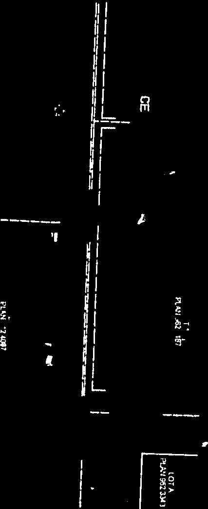
14 Issue Summary Report 5.1. PT. NW W6; PLAN ; BLOCK 1; LOT 1 & PLAN ; BLOCK 1; LOT 2/ JOHAN, SARA, JEREMY & BETTY KLASSEN/ HELIX SURVEYS LTD./ FILE NO. PLSUB # Meeting : September 26, 2017 Municipal Planning Commission Meeting Type : Municipal Planning Commission Presenter : Yasmin Sharp, Planner Section : SUBDIVISION APPLICATIONS Meeting Date : 2017/09/26 10:00 Executive Summary Pt. NW W6; Plan ; Block 1; Lot 1 and Plan ; Block 1; Lot 2. Located 2 miles east of the Hamlet of Clairmont, adjacent to RGE RD 52. Application is to adjust the boundary of the lots located on Pt. NW W6 in order to increase the size of existing Plan ; Block 1; Lot 2. The portion of land is currently zoned as a Country Residential (CR-5) District. Council District 2. Recommendation It is recommended that the boundary adjustment application be approved. Page 14 of 67
15 Appendix 1 for 5.1.: PLSEUB PLSUB Johan & Sara Klassen and Jeremy & Betty Klassen Helix Surveys Ltd. 202, Avenue Grande Prairie, AB T8W 0K8 Pt NW W6; Plan ; Block 1; Lot 1 and Plan ; Block 1; Lot 2. Located 2 miles east of the Hamlet of Clairmont, adjacent to RGE RD 52. Application is to adjust the boundary of the lots located on Pt. NW W6 in order to increase the size of existing Plan ; Block 1; Lot 2. The portion of land is currently zoned as a Country Residential (CR-5) District. COUNTY STAFF: In considering this application, the subdivision authority must consider the following information in accordance with Section 7 of the Subdivision and Development Regulations: 1) Topography: The applicant describes the topography as flat with trees and bush. 2) Soil Characteristics: a) Subsurface characteristics i) Susceptibility to slumping or subsidence: No information provided. ii) Depth to water table: No information provided. iii) Suitability for on-site sewage disposal system: Deemed adequate. 3) Storm Water collection and disposal: No issues identified. 4) Potential for flooding, subsidence or erosion of land: No build zone caveat placed on title as part of previous subdivision. 5) Accessibility to a Road: Access exists via RGE RD 52. 6) Availability and adequacy of water supply: Deemed adequate 7) Availability and adequacy of sewage disposal: Deemed adequate. a) Report prepared by a qualified individual: No report required. b) Proposed method of sewage disposal: On-site sand mound. c) Suitability and viability of proposed method: Deemed adequate. Page 15 of 67
16 Appendix 1 for PLSUB : PLSEUB NW W6 8) Availability and adequacy of solid waste disposal: Deemed adequate. 9) Use of the land in the vicinity of the application: Land uses in the area consists of predominantly Agricultural (AG) with some Country Residential (CR-5) 10) Other matters: PUBLIC WORKS: Access exists to the parcel and balance to County Standard. Road widening was taken as part of the previous subdivision application. ADJACENT LANDOWNERS: No comments received. No concerns, subject to standard comments: Alberta Health Services, Alberta Energy Regulator, and ATCO Electric. Alberta Environment: There appears to be a water body (wetland) located south and a bit west of the dugout and situated at the end of both parcels. Approval, based on: a) the premise that the parcel of land to be created is suitable for the proposed use and fulfills the criteria identified in Section 7 of the Subdivision and Development Regulation provided all conditions are attached, and b) no objections have been received from adjacent landowners. The approval is subject to: 1. All outstanding taxes to be paid in full. 2. Municipal reserve to be provided by way of cash-in-lieu in the amount of $3, (based on a subdivision of 1 hectares the total hectares owing would be 0.10 hectares based on $32,609 per hectare). Final amount will be determined upon receipt of the final survey. Page 16 of 67


17 Appendix 1 for 5.1.: PLSEUB Page 17 of 67

18 Appendix 1 for 5.1.: PLSEUB Page 18 of 67

19 Appendix 1 for 5.1.: PLSEUB Page 19 of 67


20 Appendix 1 for 5.1.: PLSEUB Page 20 of 67
21 Appendix 1 for 5.1.: PLSEUB Yasmin Sharp From: James Proudfoot Sent: Monday, July 10, :01 PM To: Plan Cc: Marsha Trites-Russell Subject: RE: PLLUB and PLSUB Land Use Bylaw Amendment ( ; Pt NW W6M) & Subdivision Circulation Package for a Boundary Adjustment ( ; Pt NW W6 and ; Pt NW W6) (Klassen) There appears to be a water body (wetland) located south and a bit west of the dugout and situated at the end of both parcels. It is best to avoid this area during development but if avoidance is not possible, then a Water Act Approval may be required. See other comments below. In general, the act of subdividing land or rezoning it is not in itself a concern. However, the activities associated with development of and operations on the land must comply with existing legislation (Water Act) and associated policy. Excellence is the recommended standard. Considerations and recommendations pertaining to the Water Act for proposed activities that may adversely impact a water body and the aquatic environment: a biophysical assessment is often required when development is proposed for an area and its biological or physical nature is not clearly understood. This should give specific attention to water and will facilitate sound decision making. the proposed land use shall respect and sustain area water bodies. a buffer (ER) is desirable to safe guard the aquatic habitat. the riparian fringe ought to be maintained in a natural state. natural drainage shall be maintained. an appropriate setback from top of any bank is highly recommended to protect the water body (and property) from slope failure. (see Stepping Back from the Water document Guide 2012.pdf) any development that may cause drainage/flooding issues for neighbors and/or future landowners shall be avoided. development on the 1:100 year floodplain is discouraged and if proposed, all structures and development susceptible to damage from flooding ought to be flood proofed. activities impacting a water body may require an approval and an application ought to be submitted. if wetland plants are present in the area of a proposed activity, a Qualified Wetland Science Practitioner ought to assess the area to confirm the presence or absence of wetland habitat. If wetlands are present, impacts will need to be addressed under the Alberta Wetland Policy and Alberta Wetland Mitigation Directive. ( and services/wetlands/alberta wetland policy implementation.aspx). stormwater shall be managed; release from property ought to be at predevelopment rates and address water quantity issues (ex. erosion) and quality issues (ex. siltation) so as not to result in an adverse effect. the construction of dugouts, borrow pits, stormwater ponds and other pits may require an approval (See guide). guidelines/documents/dugoutspitsexcavationguide Jun pdf pertinent best management practices are recommended. Responses to Referrals may be provided as a means of cooperating with regulatory partners to facilitate sustainable development. However, if a response is not received from the Department with respect to a referral, the lack of response shall not be interpreted as a representation of the Department of any kind. The Water Act and associated legislation and policy must be followed (including Codes of Practice). This list of concerns may not be complete and is based on current legislation and policy which may change in the future. For legislation, education and guideline materials, go to: Please call if you have any questions or require clarification on any issue or comment above. 1 Page 21 of 67
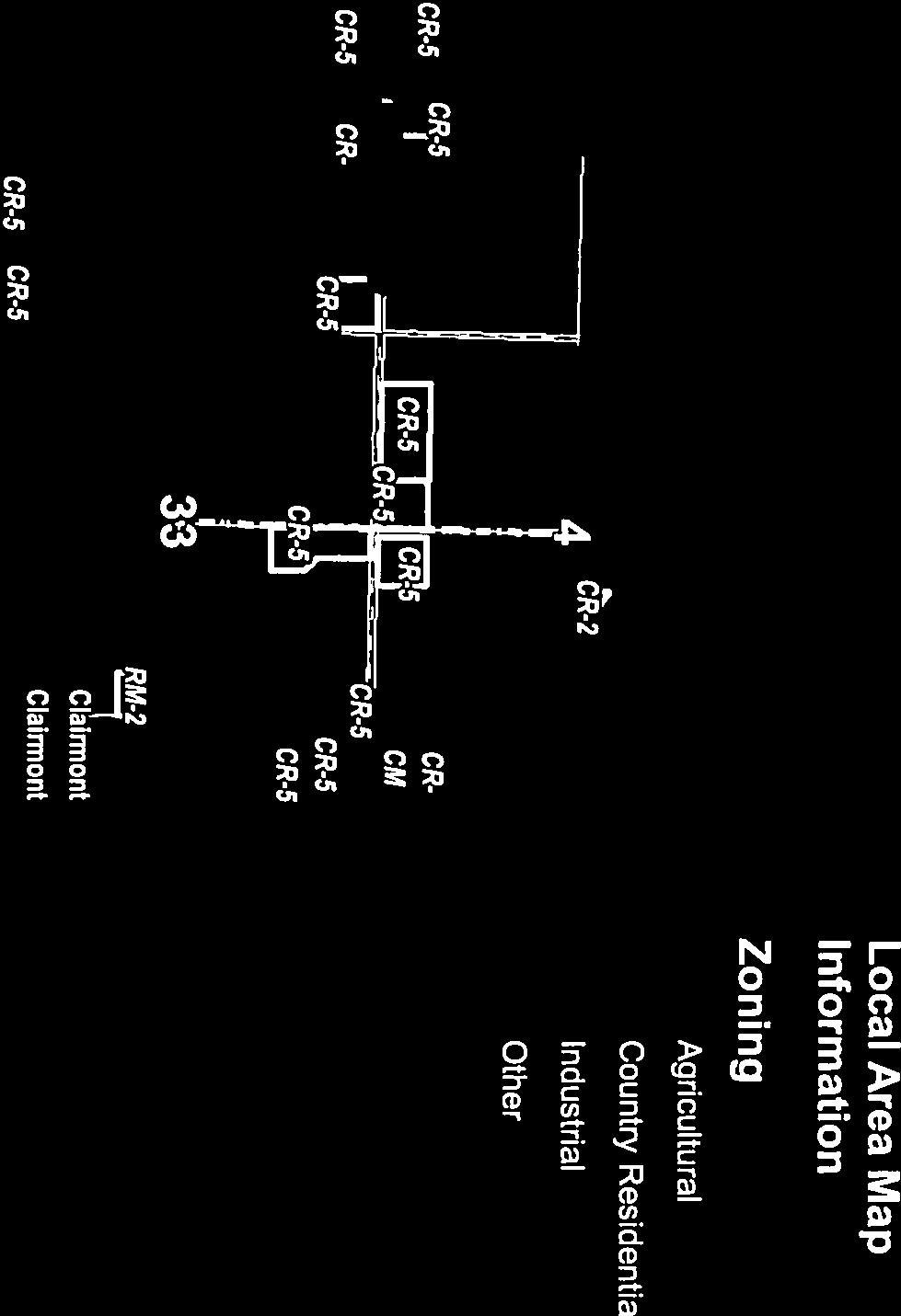
22 Issue Summary Report 5.2. PT. NE W6; PLAN ; BLOCK 1; LOT 6 & 7/ BLACKROCK BUSINESS GROUP INC. & KEVIN AND NADINE DUECK/ # HELIX SURVEYS LTD./ FILE NO. PLSUB Meeting : September 26, 2017 Municipal Planning Commission Meeting Type : Municipal Planning Commission Presenter : Baily Lapp Section : SUBDIVISION APPLICATIONS Meeting Date : 2017/09/26 10:00 Executive Summary Plan ; Block 1; Lot 6 & 7; Pt. NE W6: located within The Ranch, a multi-lot residential subdivision 5 miles south west of the City of Grande Prairie, adjacent to an internal subdivision road. Council District 4. Page 22 of 67
23 Appendix 1 for 5.2.: PLSUB Summary Package SUBDIVISION APPLICATION FILE NO.: LANDOWNERS: APPLICANT: LEGAL DESCRIPTION: PLSUB Blackrock Business Group Inc. & Kevin and Nadine Dueck. Helix Surveys Ltd th Avenue Grande Prairie, AB T8W 0K8 Plan ; Block 1; Lot 6 & 7; Pt. NE W6: located within The Ranch, a multi-lot residential subdivision 5 miles south west of the City of Grande Prairie, adjacent to an internal subdivision road. PROPOSAL: Application for a boundary adjustment of proposed Block 1; Lot 9 & 10 within NE W6. The portion of land is currently zoned as a Country Residential (CR-2) District. COMMENTS: COUNTY STAFF: In considering this application, the subdivision authority must consider the following information in accordance with Section 7 of the Subdivision and Development Regulations: 1) Topography: The applicant describes the topography as flat. 2) Soil Characteristics: a) Subsurface characteristics i) Susceptibility to slumping or subsidence: No issues identified. ii) Depth to water table: No information provided. iii) Suitability for on-site sewage disposal system: Deemed adequate. 3) Storm Water collection and disposal: No issues identified. 4) Potential for flooding, subsidence or erosion of land: No issues identified. 5) Accessibility to a Road: Access provided via internal subdivision road. 6) Availability and adequacy of water supply: Connection to municipal water services is required. 7) Availability and adequacy of sewage disposal: a) Report prepared by a qualified individual: Geotechnical Investigation prepared by J.R. Paine & Associates Ltd. b) Proposed method of sewage disposal: Proposed Lot 9 has existing systems. In 2015, a Geotechnical report was registered Page 23 of 67
24 Appendix File Number: 1 for PLSUB : PLSUB Subdivision Summary Application Package Legal Description: Plan ; Block 1; Lot 6 & 7; Pt. NE W6 on title when The Ranch Phase 5 was approved and according to that document, a mound system is suitable for proposed Lot 10. c) Suitability and viability of proposed method: Deemed adequate. 8) Availability and adequacy of solid waste disposal: Deemed adequate. 9) Use of the land in the vicinity of the application: The proposed boundary adjustment is located within a multi-lot residential subdivision, The Ranch. Therefore, Administration does not anticipate any land use conflicts with this application. County Public Works Department: The access approaches into the proposed lots exist and are provided to County standard. Safety Code Manager: The private sewage disposal condition is not required for this subdivision. Adjacent Landowners: No comments received No concerns, subject to standard comments: Alberta Energy Regulator, ATCO Electric, Alberta Health Services, ATCO Pipelines and Aquatera. RECOMMEND: Approval, based on: a) the premise that the parcel of land to be created is suitable for the proposed use and fulfills the criteria identified in Section 7 of the Subdivision and Development Regulation provided all conditions are attached, and b) no objections have been received from adjacent landowners. The approval is subject to: 1. All outstanding taxes to be paid in full. Page 24 of 67


25 Appendix 1 for 5.2.: PLSUB Summary Package Page 25 of 67


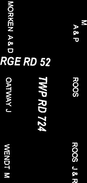
26 M D TYR K U S, D & C O W S MT IN C MT IN C Appendix 1 for 5.2.: PLSUB Summary Package File No: PLSUB Councillor District: 4,4 Legal Description: NE W6 Plan, Block, Lot: ;1;6 WHITE, C & M LOCATION C AM ER O N, A & R CAMERON, T ALBERTA LTD C A ME R ON, C & J C H AT E A U, R MASON, D & D D IK A, N TWP RD 710 MASON, D & D POWELL, P GINA HOMMY FLECK, R & E HOLDINGS LTD TOERPER, M & S MC C U R D Y, T & J SA V ID AN, T & R GILL, C STE R K EN B U E RG, D & A LEBRUN, B & K PETERSON, D & C DUBE, V & TAUTRIMS, G 32 CAMERON, C PARK MEADOWS MOFFETT, T & RENSCHLER MAYER, J & B MYSTIC RIDGE GABLE, K & W EDEY, V & S DYKSTR A, TINK, D 29 MASON, A & S METITUK, M & JANTZ, B MC D ON A LD, G & D POWELL, A CHOR NEY, R & D TAYL OR, S & J POW ELL, T & M WATTEL, L LEMIRE, D & K THE RANCH PROPERTIES INC CLERGUE, MC N E IL, R & M MC B U R NE Y, C & M SPELREM, M COFFEY, D & C LEICHT, D MCCURDY, B & B MALIN, J & S MCKIM, D & C HUNT, D & T BREMONT, NOEL, R & J H U D S O N, B ST ON EB U ILT HOM ES LT D C R A M M, S & R MO W A T, S & D BOND, BUD D E, J & J S KL U Y T, J & T ZIN I U K, T & T MA R T I N, C & B GREEN, A MASON, A & S DEER RIDGE ESTATES THE RANCH SH I ELD S, G & J GR EEN, A TAYLOR, J & MCCARROLL, K DEER RUN ESTATES R PU R ZY S K I, D & N ALLOWAY, W & L CHMILAR, D KLYM, M & S CLARKE, D & P THE RANCH PROPERTIES INC MY C R OFT, R & K WRIGHT, B PROVINCE OF ALBERTA CLARKE, D & P DUNES WEST FIN C H, T & BI N KS, R TAM A S I, C & G GREER, D & P 33 GEBHART, K FINCH, I & MCAUSLAND, L BIN KS, R & FI N CH, T & W NORTHERN METALIC SALES (ALTA) LTD THE RANCH PROPERTIES INC THE RANCH PROPERTIES INC HESSE, J & M KLYM, M GEOFFREY C. IBBOTSON PROFESSIONAL CORPORATION FINCH, W & MARTIN, L OLSON, D & L CASE, J & M FINCH, J & T SINCLAIR, J KOTAN KO, J & S IS ELE, D & K SHORT, M & S CO TTR E LL, J CASE, J & M LALI BE R TE, R & H TWP RD 704 FOSTER, J SINC LAIR, H & C SUNRISE II ESTATES LITTLE, N & R LUC K, G & L ALBERTA ENERGY & NATURAL RESOURCES W ILS ON, LALIBERTE, R & H SINCLAIR, L 109 ST NO OY, D & C 27 AVE COOKE, G MT IN V ES TM EN T S IN C TINK, J & DONIS, B DODD, F & K ALBERTA ENERGY & NATURAL RESOURCES WAPITI NORDIC SKI CLUB HWY 40 INDUSTRIAL PARK SUNRISE ESTATES RGE RD 62 HWY 40 COWAN, D & C DAY, C PR OV IN C E OF A LB ER TA TEMPLE, NORRIS, B & R YOUNG, R & C ALBERTA LTD RGE RD 62 VA N B E R G, E & M Grande Prairie HO GG, A & J SANDY LANES ESTATES PR OV IN C E OF A LBE R TA LEIPPI, A & M WA LLA N, S & J CAMP TAMARACK ASSOCIATION PROVINCE OF ALBERTA 35 Wapiti River RE N R ON HO LD IN GS IN C 38 AVE TAMARACK ESTATES ALBERTA LTD RGE RD 61 AFR ID I, ALBERTA ENERGY & NATURAL RESOURCES COUNTY INDUSTRIAL PARK HWY 668 HOMM Y, G VE R MA AT HO LD IN G C O. LTD & TR E N E BR EK K A A S VA C U U M & TAN K LTD MINHAS BR OS. HOLDINGS LTD CLOUTIER, R & K 93 ST ALB ER TA IN C THE DUNES GOLF & WINTER CLU B IN C AQUATERA UTILITIES INC IN V ES TM EN T S IN V ES TM EN T S THE DUNES GOLF & WINTER CLUB INC DUNES SW A N ST ON, B & N N.P.A. LTD N.P.A. LTD N.P.A. LTD N.P.A. LTD MINHAS BROS. HO LDINGS LTD MINHAS INDUSTRIAL 36 PARK 25 PLA N TE, J & S ALBERTA ENERGY & NATURAL RESOURCES MANDALAY ESTATES DUNES ON 17 Wapiti River M.D. Of Greenview No. 16 1:50,000 ZONING CR-5 RGE RD 64 Local Area Map Information ± CR-2 CR-2 CR-2 MYSTIC RIDGE CR-5 CR-2 CR-3 29 CR-3 CR-2 CR-3 CR-3 CR-2 DEER RIDGE ESTATES TWP RD 704 CR-2 CR-2 CR-2 CR-5 Zoning Agricultural Country Residential Industrial Other Named Subdivisions THE RANCH CR-2 RGE RD 65 CR-5 CR-5 CR-5 TWP RD 703A 20 CR-2 CR-5 CR-2 CR-2 CR-2 CR-5 CR-5 CR-5 CR-5 DUNES WEST CR-5 CR-5 1:24,000 CR-5 This GIS product is comprised of many layers of information that are maintained by other external data p roviders. The County of Grande Prairie assumes no responsibility nor liability for the accuracy or completeness of these data layers. The County of Grande Prairie makes no representation or warranties regarding the informati on contained in this document, including without limitation, whether said information is accurate or complete. Persons using this document do so solely at their own risk, and The County of Grande Prairie shall have no liability to such person for any loss or damage wh atsoever. This document shall not be copied or distributed to any person without the express written consent to the County of Grande Prairie. Copyright 2016 County of Grande Prairie. All Rights Reserved. Page 26 of 67
27 Appendix 1 for 5.2.: PLSUB Summary Package Page 27 of 67
28 Appendix 1 for 5.2.: PLSUB Summary Package Page 28 of 67
29 Appendix 1 for 5.2.: PLSUB Summary Package Page 29 of 67
30 Appendix 1 for 5.2.: PLSUB Summary Package Page 30 of 67
31 Issue Summary Report 5.3. PT. NE W6/ ALBERTA LTD./ BEAIRSTO & ASSOCIATES ENGINEERING LTD./ FILE NO. PLSUB # Meeting : September 26, 2017 Municipal Planning Commission Meeting Type : Municipal Planning Commission Presenter : Baily Lapp Section : SUBDIVISION APPLICATIONS Meeting Date : 2017/09/26 10:00 Executive Summary Pt. NE W6: located 2.5 miles west of the Town of Beaverlodge, adjacent to RGE RD 104. Council District 5. Page 31 of 67
32 Appendix 1 for 5.3.: PLSUB Summary Package SUBDIVISION APPLICATION FILE NO.: LANDOWNERS: APPLICANT: LEGAL DESCRIPTION: PROPOSAL: PLSUB Alberta Ltd. Beairsto & Associates Engineering Ltd. 101, Ave Grande Prairie, AB T8V 6B5 Pt. NE W6: located 2.5 miles west of the Town of Beaverlodge, adjacent to RGE RD 104. Application to subdivide one (1) lot of 4 hectares (9.89 acres) from part of NE W6. The portion of land is currently zoned as a Country Residential (CR-5) District. COMMENTS: COUNTY STAFF: In considering this application, the subdivision authority must consider the following information in accordance with Section 7 of the Subdivision and Development Regulations: 1) Topography: The applicant describes the topography as flat, bare land. 2) Soil Characteristics: a) Subsurface characteristics i) Susceptibility to slumping or subsidence: No issues identified. ii) Depth to water table: No information provided. iii) Suitability for on-site sewage disposal system: Deemed adequate. 3) Storm Water collection and disposal: No issues identified. 4) Potential for flooding, subsidence or erosion of land: No issues identified. 5) Accessibility to a Road: Access to be provided via RGE RD ) Availability and adequacy of water supply: Deemed adequate. 7) Availability and adequacy of sewage disposal: a) Report prepared by a qualified individual: Model Process documentation completed by Colin Juneau, licensed Private Sewage Contractor. b) Proposed method of sewage disposal: The proposed lot has been deemed suitable to withhold landowner s choice of a pump Page 32 of 67
33 Appendix File Number: 1 for PLSUB : PLSUB Subdivision Summary Application Package Legal Description: Pt. NE W6 out system, mound system or lagoon. c) Suitability and viability of proposed method: Deemed adequate. 8) Availability and adequacy of solid waste disposal: Deemed adequate. 9) Use of the land in the vicinity of the application: Land uses in the area consist of agricultural land uses with clustered country residential development to the southeast of the application. Administration does not anticipate any land use conflicts with this application. County Public Works Department: The access approach to the proposed parcel does not exist and must be provided to County standard. The access approach to the balance of the quarter section exists and is provided to County standard meters of road widening is required on the east boundary of the quarter section. Adjacent Landowners: No comments received. No concerns, subject to standard comments: ATCO Pipelines, Telus, Alberta Health Services, ATCO Electric and Alberta Energy Regulator. RECOMMEND: Approval, based on: a) the premise that the parcel of land to be created is suitable for the proposed use and fulfills the criteria identified in Section 7 of the Subdivision and Development Regulation provided all conditions are attached, and b) no objections have been received from adjacent landowners. The approval is subject to: 1. All outstanding taxes to be paid in full. 2. Applicant to provide an access approach into the proposed parcel to the satisfaction of the County of Grande Prairie No. 1 and in accordance with Rural Servicing Standards for Subdivisions and Road Construction, prior to final endorsement of the subdivision. 3. Applicant to provide 5.03 metres road widening by caveat off of the east boundary of the quarter section as per Section 662 of the Municipal Government Act. 4. Model process documentation, provided by the applicant, is to be placed on the new titles by caveat. Page 33 of 67

34 Appendix 1 for 5.3.: PLSUB Summary Package Page 34 of 67
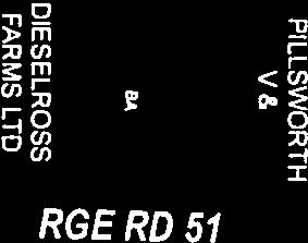
35 I LTD Appendix 1 for 5.3.: PLSUB Summary Package File No: PLSUB Legal Description: NE W6 Councillor District: 5 LOCATION ADAMS, T ALBERTA LTD WILLIS, D & G W ILLIS, D & G LEBLANC, H MONCRIEFF, R & J CR-5 TRUDEL, R & K ZONING CR-5 CR-5 WILLIS, D & G BAIRD, K ARSAM ASOW, V & A CALVERT, R & D REYNOLDS, J & GARTNER, A HO GA N, NI EL SEN, B & MO NC R IE F F, R W SIE BER T, A & S RGE RD 105 RGE RD 105 QU ESNEL, L & T CO OK, C COOK, C COOK, C MAAS, R & A MAAS, R & A BAIRD, K & S COOK, C COOK, C ALBERTA LTD MAAS, R & A BAIRD, K BAIRD, J & M COOK, C COOK, C CAGE, L D E SC H I PP E R, M & G R OA T, W SM ITH, D & J SMITH, D & J RGE RD 104 CR-5 ± Local Area Map 9 AG Information RGE RD 104 TYE, D & S BR EK K A AS, L & T WA IN W R I GH T, D & B ROURKE, M & K ROURKE, M & K HILL, R & T ALBERTA LTD ALBERTA LTD CAGE PETROLEUM LTD SCHMIDT, G & G ALDRED, G & P MORSAN FARMS LTD MORSAN FARMS LTD ALBERTA LTD ALBERTA LTD ALBERTA LT D HIPKINS, J & J WILLIS, D & P CA R LS TAD, H & JEW IT T, L ALBERTA LTD WILLIS, G & B WILLIS, G & B ALBE RTA LTD CARLSTAD, H & JEWITT, L HIPKINS, J & J ALBERTA LTD & ALBERTA LTD RGE RD 103 HIPKINS, J & J BABUIK, K & S BATRYN, TWP RD 720 WILLI S, D W ILLIS, D & CALLIO U, M CR-5 NO R DH A GEN, K CR ALBERTA LTD ALBERTA LTD TWP RD ALBERTA LTD BRISTOW, S B R O W N, D & C BROWN, D & C PR OVI N CE OF A LB ER TA BROWN, R & C ALB ER TA 10 SOU T H P EA C E CE N TE N N IA L MU S EU M JOHNSON, E & JOHNSON, R JOHNSON, R & E KENNEDY TOWERS LTD GAUDIN, G & H HWY 43 HWY 722 BRISTOW, S Zoning HWY 722 RGE RD 102 Agricultural KJB HOLDINGS INC Beaverlodge HILL, W HILL, W Country Residential Industrial Other PRT GROWING SERVICES LTD 1:40,000 FOS TER, N & TH IESSE N, D 5 CR-5 CR-5 Beaverlodge River 4 CR-5 RGE RD 105 CR-2 CR-2 CR-5 TWP RD 720 CR-5 CR-5 CR-5 AG AG AG 1:24,000 This GIS product is comprised of many layers of information that are maintained by other external data p roviders. The County of Grande Prairie assumes no responsibility nor liability for the accuracy or completeness of these data layers. The County of Grande Prairie makes no representation or warranties regarding the informati on contained in this document, including without limitation, whether said information is accurate or complete. Persons using this document do so solely at their own risk, and The County of Grande Prairie shall have no liability to such person for any loss or damage wh atsoever. This document shall not be copied or distributed to any person without the express written consent to the County of Grande Prairie. Copyright 2016 County of Grande Prairie. All Rights Reserved. Page 35 of 67


36 Appendix 1 for 5.3.: PLSUB Summary Package Page 36 of 67


37 Appendix 1 for 5.3.: PLSUB Summary Package Page 37 of 67


38 Appendix 1 for 5.3.: PLSUB Summary Package Page 38 of 67


39 Appendix 1 for 5.3.: PLSUB Summary Package Page 39 of 67
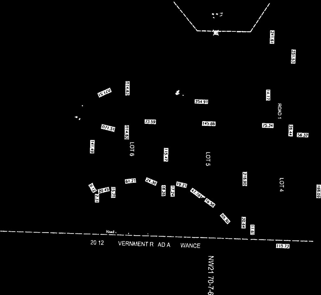
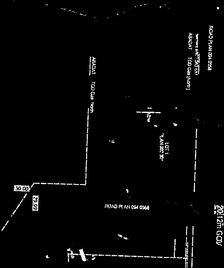
40 Issue Summary Report 5.4. PT. NE / JORDAN JOHNSEN/ BEAIRSTO & ASSOCIATES ENGINEERING LTD./ FILE NO. PLSUB # Meeting : September 26, 2017 Municipal Planning Commission Meeting Type : Municipal Planning Commission Presenter : Jeremy Dela Cruz Section : SUBDIVISION APPLICATIONS Meeting Date : 2017/09/26 10:00 Executive Summary Pt. NE W6: located approximately 5 miles south of the Hamlet of Dimsdale, adjacent to TWP RD 704. The applicant is proposing the subdivision of three (3) lots ranging from 1.57 ha (3.88 ac) to 2.72 ha (6.72 ac). This is located within NE W6. The portion of land is currently zoned as a Country Residential (CR-2) District. Council District 4. Page 40 of 67
41 Appendix 1 for 5.4.: PLSUB SUBDIVISION APPLICATION FILE NO.: LANDOWNERS: APPLICANT: LEGAL DESCRIPTION: PROPOSAL: COMMENTS: PLSUB Jordan Johnsen Beairsto & Associates Engineering Ltd. 101, Ave Grande Prairie, AB T8V 6B5 Pt. NE W6: located approximately 5 miles south of the Hamlet of Dimsdale, adjacent to TWP RD 704. The applicant is proposing the subdivision of three (3) lots ranging from 1.57 ha (3.88 ac) to 2.72 ha (6.72 ac). This is located within NE W6. The portion of land is currently zoned as a Country Residential (CR- 2) District. COUNTY STAFF: In considering this application, the subdivision authority must consider the following information in accordance with Section 7 of the Subdivision and Development Regulations: 1) Topography: The applicant describes the topography as mixed with the characteristics of the land is treed. 2) Soil Characteristics: a) Subsurface characteristics i) Susceptibility to slumping or subsidence: Proposed lots are located adjacent to a steep slope. A Slope Stability Study was done, which outline the appropriate setback from the top of bank. Applicant has set their property line accordingly to ensure there is an appropriate development setback. Administration request that the report be placed on each proposed Lot. This will be a condition of the subdivision approval. ii) Depth to water table: No information provided. iii) Suitability for on-site sewage disposal system: Deemed adequate. 3) Storm Water collection and disposal: No issues identified. 4) Potential for flooding, subsidence or erosion of land: A water run is located along the east boundary of quarter section and road right of way. This water run continues south and eventually goes into the Wapiti River. 5) Accessibility to a Road: Access to the proposed Lots will be provided Page 41 of 67
42 Appendix File Number: 1 for PLSUB : PLSUB Legal Description: Pt. NE W6 off a private internal road, which will come off TWP RD ) Availability and adequacy of water supply: connect to municipal service. 7) Availability and adequacy of sewage disposal: a) Report prepared by a qualified individual: Report provided by Perfection Backhoe Services Ltd. b) Proposed method of sewage disposal: Proposed Septic Tank and Field System. c) Suitability and viability of proposed method: Deemed adequate. 8) Availability and adequacy of solid waste disposal: Deemed adequate. 9) Use of the land in the vicinity of the application: Land uses in the area consist of Agricultural and Country Residential Districts. Administration does not see any land use conflicts to arise. 10) Other matters: Administration: Administration advised the applicant to relocate the proposed access coming off Range Road 74. Council supported Administration and told the Applicant to relocate the access further west where there was an existing internal road. They have complied with the request and the revised plan shows that the access to the lots will be off the internal road. The County does not require anymore road widening. The applicant does have access to the balance but will be required to construct and extend the internal road to provide access to the proposed Lots. Safety Codes has no concerns with this application. Municipal Reserve and Transportation Levy are applicable to this application. West Aqua CO-OP Line is located at the intersection of TWP RD 704 and RGE RD 74. Half mile from the proposed application and Administration is requesting that the applicant extend the West Aqua infrastructure to the proposed development and pay all associated fees to County and Aquatera at the cost of the applicant. ADJACENT LANDOWNERS: No comments received. No concerns, subject to standard comments: Alberta Energy Regulator, ATCO Pipelines, Alberta Health Services, and Telus Communications Page 42 of 67
43 Appendix File Number: 1 for PLSUB : PLSUB Legal Description: Pt. NE W6 Inc. Aquatera: Is in support of subdivision and requests applicant to extend West Aqua Line to proposed development (See attachment). Alberta Environment: See attachment. ATCO Gas: Has existing easement and request to carry the easement over (See attachment). RECOMMEND: Approval, based on: a) the premise that the parcel of land to be created is suitable for the proposed use and fulfills the criteria identified in Section 7 of the Subdivision and Development Regulation provided all conditions are attached, and b) no objections have been received from adjacent landowners. The approval is subject to: 1. All outstanding taxes to be paid in full. 2. Applicant to construct internal road as indicated on the tentative plan. As well, provide an approach into each of the proposed parcels to the satisfaction of the County of Grande Prairie and in accordance with Rural Servicing Standards for Subdivisions and Road Construction. 3. Municipal reserve to be provided by way of cash-in-lieu in the amount of $11, (based on a subdivision of 7.53 hectares the total hectares owing would be hectares based on $14, per hectare). Final amount owed will be based on the final survey. 4. Applicant entering into a development agreement with the County of Grande Prairie No. 1 for the provision of municipal services, road improvements and offsite levies. As per Bylaw 2702, the road improvement levy for Zone 3 is to apply. 5. The Applicant is required to pay all West Aqua Water Line Recovery Charges. 6. Model process documentation, provided by the applicant, is to be placed on the new titles by caveat. 7. Slope Stability Report is to be placed on the new title of the proposed Lots by caveat, this shall be prepared and registered by the applicant. Page 43 of 67

44 Appendix 1 for 5.4.: PLSUB Page 44 of 67


45 Appendix 1 for 5.4.: PLSUB Page 45 of 67


46 Appendix 1 for 5.4.: PLSUB Page 46 of 67
47 Appendix 1 for 5.4.: PLSUB Page 47 of 67

48 Appendix 1 for 5.4.: PLSUB Planning Department Scale 1:45,283 Legend West Aqua Coop Main Road Labels Railroads Provincial Highways The County of Grande Prairie No. 1 m akes no representation or warranties regarding the information contained in this document, including, without lim itation, whether the said information is accurate or complete. Persons using this document do so solely at their ow n risk, and the County of Grande Prairie No. 1 s hall have no liablilty to such pers ons for any loss or damage whatsoever. N am es m ay appear different than how they are registered with Alberta Land Titles. This document may not be c opied or distributed to any other person without the express written consent of the County of Grande Prairie No Avenue, Clairmont, AB. T0H 0W0 County of Grande Prairie No. 1 Enterprise Web Map Phone: info@countygp.ab.ca NOT RESPONSIBLE FOR ERRORS OR OMISSIONS. Page 48 of 67

49 Appendix 1 for 5.4.: PLSUB PLSUB Scale 1:90,567 Leg en d Township and Range Grid Quarter Labels Federal Area Boundary Municipal Boundaries City / County Com munity / Rural Com munity Ham let Regional District Town / Village Parks Sub divisions Industrial Subdiv ision Manufactured Hom e Com munity Res idential Subdiv ision Unincorporated Com munity The County of Grande Prairie No. 1 m akes no representation or warranties regarding the information contained in this document, including, without lim itation, whether the said information is accurate or complete. Persons using this document do so solely at their ow n risk, and the County of Grande Prairie No. 1 s hall have no liablilty to such pers ons for any loss or damage whatsoever. N am es m ay appear different than how they are registered with Alberta Land Titles. This document may not be c opied or distributed to any other person without the express written consent of the County of Grande Prairie No Avenue, Clairmont, AB. T0H 0W0 County of Grande Prairie No. 1 Enterprise Web Map Phone: info@countygp.ab.ca NOT RESPONSIBLE FOR ERRORS OR OMISSIONS. Page 49 of 67


50 Appendix 1 for 5.4.: PLSUB Page 50 of 67


51 Appendix 1 for 5.4.: PLSUB Page 51 of 67


52 Appendix 1 for 5.4.: PLSUB Page 52 of 67
53 Issue Summary Report 6.1. PLAN ; BLOCK 2; LOT 1; PT. NE W6/ PHILLIP & LANA DYCK/ HOME OCCUPATION MAJOR/ FILE NO. PLDEV # Meeting : September 26, 2017 Municipal Planning Commission Meeting Type : Municipal Planning Commission Presenter : Yasmin Sharp Section : DEVELOPMENT PERMIT APPLICATIONS Meeting Date : 2017/09/26 10:00 Executive Summary Plan ; Block 2; Lot 1; PT. NE W6 located 1.5 miles northwest of the Hamlet of Clairmont; adjacent to TWP RD 730. Development Permit application is for a Home Occupation Major Lanco Construction 5 employees (4 working in the shop and 1 receptionist), Shop (60 x 100 ), One Semi-truck, One 3 Tonne Truck, Tractor, Forklift and Outdoor Storage of lumber and equipment. Operating Monday to Saturday 7AM 5PM. Greenhouse (20 x 72 ), Four Sheds (14 x 20 ), Barn (40 x 42 ) and Dugout. Council District 2. Recommendation It is recommeded that this application be refused due to the unsuitability of the site and because the proposed Home Occupation, Major exceeds the scale outlined in the Land Use Bylaw. Page 53 of 67
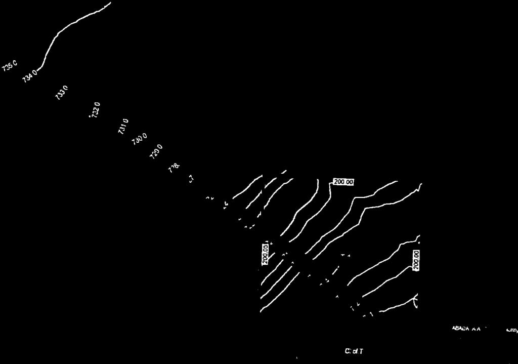
54 Appendix 1 for 6.1.: PLDEV PLDEV Phillip & Lana Dyck Phillip & Lana Dyck Plan ; Block 2; Lot 1; NE W6 located 1.5 miles northwest of the Hamlet of Clairmont; adjacent to Township Road 730. Development Permit application is for a Home Occupation Major Lanco Construction 5 employees (4 in the shop and 1 receptionist), Shop (60 x 100 ), One Semi-truck, One 3 Tonne truck, Tractor, Forklift and Outdoor Storage of lumber and equipment. Operating Monday to Saturday 7AM 5PM. Greenhouse (20 x 72 ), Four Sheds (14 x 20 ), Barn (40 x 42 ) and Dugout. COUNTY STAFF: The Land Use Bylaw designates this parcel as a Country Residential (CR-5) District. Home Occupation Major, including accessory buildings, outdoor storage, equipment and employees are a discretionary use within this district. The additional accessory buildings and dugout are also considered discretionary. The County Land Use Bylaw states that a Home Occupation, Major business must be secondary to the residential use of the building and shall not change the residential character of the dwelling unit and/or accessory building. This may include limited storage of trucks and related vehicles and minor equipment storage including a limited amount of construction equipment and other similar uses. In addition, there must be fewer than 3 non-resident employees. The application for Lanco Construction and all related developments exceeds the definition of Home Occupation, Major outlined in the Land Use Bylaw. However, the more pressing concern is the suitability of the lot to support additional development. Plan ; Block 2; Lot 1; was subdivided in 2015 for residential use by the previous landowners. As part of the review process Administration determined that the area was subject to flooding and a Hydrotechnical Report was conducted by Northwest Hydraulic Consultations to determine the severity of the flooding. The map developed as part of the report illustrates the 100 Water Elevations and flood plain area and is Page 54 of 67
55 Appendix 1 for 6.1.: PLDEV PLDEV Plan ; Block 2; Lot 1; NE W6 included within the package. As indicated, a limited area is suitable for development, and already holds the residence. Mr. Dyck initially applied for the development permit in March Upon receipt of the application, he was informed by the Planning Department of the Report, which had been placed on title by caveat, outlining the development limitations on his property. He was advised that a development permit could not be considered without an engineered plan addressing the water issues. In August 2017, Mr. Dyck provided a site plan from Beairsto & Associates Engineering. The site plan contemplates moving dirt from the rear of the lot to the desired building sites, in addition to clay slabs, to increase their elevation to the same level as the residence. This would divert water, creating a large pond where the dirt was removed and would require Water Act Approval from Alberta Environment. The site plan does not take into account how this water diversion will affect surrounding landowners. In light of the technical reports conducted and placed on title at the time of subdivision, the comments received from the area foreman s communicating the unsuitability of the site, the unknown impacts of diverting water in the area and concerns expressed by adjacent landowners, Administration recommends that this application not be approved. COUNTY PUBLIC WORKS: Low wet land subject to flooding in the spring and heavy rain, no build zone and wetland assessment required. Clay slabs are susceptible to erosion. ADJACENT LANDOWNERS: See attached. Refusal due to unsuitability of the site and because the proposed Home Occupations, Major exceeds the scale outlined in the Land Use Bylaw. Page 55 of 67


56 Appendix 1 for 6.1.: PLDEV Page 56 of 67


57 Appendix 1 for 6.1.: PLDEV Page 57 of 67


58 Appendix 1 for 6.1.: PLDEV Page 58 of 67


59 Appendix 1 for 6.1.: PLDEV Page 59 of 67
 EXJSTING GRADE 10940 92 Avenue, Grande Prairie, NJ T8V 685 Pa 780 532 4919 Pa 780 532 4739 Wa www.")
 \ \ \ \ \ \")

60 Appendix 1 for 6.1.: PLDEV Bealrsto&As t "> DESIGN GRAUt ">') EXJSTING GRADE Avenue, Grande Prairie, NJ T8V 685 Pa Pa Wa Cioni.Jobi BASE.Jobi DYCK 17GEME6040 FARMYARD PLOT PLAN PLAN BLOCK _ 2 _ LOT 1 COUNTY OF GRANDE PRAIRIE NO. 1 SCALE 1:1000 MUNICIPAL ADDRESS: T\W RD 7JO ZONING CR,5 JU( DATE DRAWN: JUL 20, I \ GOVERNMENT ROAD ALLOWANCE (1WP RD 730) \ \ \ \ \ \ \ \ \ \ \ \ ', OJm MV Pl.AN 4-M7 KS ', r I ' ' ACCESS SHOP ("1XIOO') "Storage units" are parking stalls 7.JJOO ! ol735 7! 1 I I :!q I I 21!ii!ii I l ili :!i i ' _J - I -' N.E W.6M. All ELEVATIONS ARE GEODETIC AND BASED OFF OF ASCM , 345<k BUILDERS ARE RESPONSIBLE TO ENSURE STAKEOUT REPRESENTS FINAL HOUSE PLANS ANO DESIRED OFFSETS ANO ELEVATIONS ANY EXCAVATION OR CONSTRUCTION PRIOR TO ALL APPROVALS IS AT BUILDERS RISK Page 60 of 67


61 Appendix 1 for 6.1.: PLDEV Page 61 of 67


62 Appendix 1 for 6.1.: PLDEV Page 62 of 67
63 Appendix 1 for 6.1.: PLDEV Page 63 of 67

64 Appendix 1 for 6.1.: PLDEV Page 64 of 67
65 XS Appendix 1 for 6.1.: PLDEV XS N XS XS XS XS EXISTING BUILDING XS GRANDE PRAIRIE CREEK Filename: P:\_Projects (Active)\ County of Grande Prairie Flood Study\04_Drawings\LiDAR Surface.dwg, 10/09/2015 9:16:29 AM September 2015 Issued for Review EKY No. Date Revision ENG YEAR FLOOD BOUNDARY (APPROX.) m SCALE 1:1,500 NOTES: 1. CONTOURS GENERATED FROM LiDAR DATA AND SURVEY DATA FROM BEAIRSTO & ASSOCIATES ENGINEERING LTD. 2. CONTOUR INTERVAL 0.5 m 3. ALL ELEVATION GIVEN IN METRES YEAR FLOOD BOUNDARY IS APPROXIMATE PROPOSED DEVELOPMENT AREA BRAD & ESTHER HARDER GRANDE PRAIRIE CREEK100-YEAR FLOOD DELINEATION NE W6M PLAN VIEW OF 100-YR FLOOD BOUNDARY (APPROX.) Dwg SEP-2015 Figure 4 northwest hydraulic consultants ltd. Page 65 of 67
 0+437.68 EXISTING BUILDING 675.00 673.")
66 GRANDE PRAIRIE CREEK Appendix 1 for 6.1.: PLDEV N YEAR FLOOD BOUNDARY (APPROX.) EXISTING BUILDING PROPOSED DEVELOPMENT AREA Filename: P:\_Projects (Active)\ County of Grande Prairie Flood Study\04_Drawings\LiDAR Surface.dwg, 10/09/2015 9:16:29 AM September 2015 Issued for Review EKY No. Date Revision ENG SCALE 1:2,500 NOTES: 1. CONTOURS GENERATED FROM LiDAR DATA AND SURVEY DATA FROM BEAIRSTO & ASSOCIATES ENGINEERING LTD. 2. CONTOUR INTERVAL 0.5 m 3. ALL ELEVATION GIVEN IN METRES YEAR FLOOD BOUNDARY IS APPROXIMATE BRAD & ESTHER HARDER GRANDE PRAIRIE CREEK100-YEAR FLOOD DELINEATION NE W6M PLAN VIEW OF 100-YR FLOOD BOUNDARY (APPROX.) Dwg SEP-2015 Figure 5 northwest hydraulic consultants ltd. Page 66 of 67


67 Appendix 1 for 6.1.: PLDEV Page 67 of 67
April 1, 2014 Municipal Planning Commission
 April 1, 2014 Municipal Planning Commission Tuesday, April 01, 2014 Start time 10:00 AM County of Grande Prairie No. 1 Community Services Building, 10808-100 Avenue, Clairmont, AB AGENDA 1. CALL TO ORDER
Issue Summary Report 4.1. MUNICIPAL PLANNING COMMISSION MINUTES FEBRUARY 4, 2014 # Commission. Executive Summary
 Issue Summary Report 4.1. MUNICIPAL PLANNING COMMISSION MINUTES FEBRUARY 4, 2014 #20140130002 Meeting : February 4, 2014 Municipal Planning Commission Meeting Type : Municipal Planning Commission Presenter
October 24, 2017 Municipal Planning Commission. Tuesday, October 24, 2017 Start time 10:00 AM County of Grande Prairie No. 1 Administration Building
 October 24, 2017 Municipal Planning Commission Tuesday, October 24, 2017 Start time 10:00 AM County of Grande Prairie No. 1 Administration Building AGENDA 1. CALL TO ORDER 2. Attendance 3. Adoption Of
May 9, 2017 Municipal Planning Commission. Tuesday, May 09, 2017 Start time 10:00 AM County of Grande Prairie No. 1 Administration Building AGENDA
 May 9, 2017 Municipal Planning Commission Tuesday, May 09, 2017 Start time 10:00 AM County of Grande Prairie No. 1 Administration Building AGENDA 1. CALL TO ORDER 2. Attendance 3. Adoption Of Agenda 4.
Issue Summary Report 4.1. MPC SEPTEMBER 10, 2013 MINUTES FOR APPROVAL # Commission. Executive Summary
 Issue Summary Report 4.1. MPC SEPTEMBER 10, 2013 MINUTES FOR APPROVAL #20130918003 Meeting : September 24, 2013 Municipal Planning Commission Meeting Type : Municipal Planning Commission Presenter : Donna
December 9, 2014 Municipal Planning Commission. Tuesday, December 09, 2014 Start time 10:00 AM County of Grande Prairie No. 1 Administration Building
 December 9, 2014 Municipal Planning Commission Tuesday, December 09, 2014 Start time 10:00 AM County of Grande Prairie No. 1 Administration Building AGENDA 1. CALL TO ORDER 2. Attendance 3. Adoption of
MINUTES OF THE MUNICIPAL PLANNING COMMISSION Tuesday, May 5, 2015 Red Deer County Council Chambers, Red Deer County Centre
 MINUTES OF THE MUNICIPAL PLANNING COMMISSION Tuesday, May 5, 2015 Red Deer County Council Chambers, Red Deer County Centre Present: Absent: Chairman Councillor P.J.R. Massier, Mayor J.J. Wood, Councillors
Minutes of a Regular Meeting of County Council RED DEER COUNTY. Tuesday, January 20, 2009
 Minutes of a Regular Meeting of County Council RED DEER COUNTY Tuesday, January 20, 2009 1.0 CALL TO ORDER The regular meeting of Red Deer County Council was held in the Council Chambers of the Red Deer
COUNTY COUNCIL MEETING AGENDA August 4, 2009 (to follow MPC Meeting)
") COUNTY COUNCIL MEETING AGENDA August 4, 2009 (to follow MPC Meeting) Page 1.0 CALL TO ORDER 2.0 APPROVAL OF AGENDA 2.1 Additional Agenda Items 3.0 MINUTES 3-8 3.1 Minutes of the regular meeting of County
COUNTY COUNCIL MEETING AGENDA August 4, 2009 (to follow MPC Meeting) Page 1.0 CALL TO ORDER 2.0 APPROVAL OF AGENDA 2.1 Additional Agenda Items 3.0 MINUTES 3-8 3.1 Minutes of the regular meeting of County
COMPLETE AND SIGN LAND USE AMENDMENT APPLICATION FORM (attached) MUNICIPAL DISTRICT OF GREENVIEW NO. 16
 MUNICIPAL DISTRICT OF GREENVIEW NO. 16") LAND USE AMENDMENT APPLICATION PACKAGE Municipal District of Greenview 4806 36 Avenue, Box 1079, Valleyview AB T0H 3N0 T 780.524.7600 F 780.524.4307 Toll Free 1.866.524.7608 www.mdgreenview.ab.ca COMPLETE
LAND USE AMENDMENT APPLICATION PACKAGE Municipal District of Greenview 4806 36 Avenue, Box 1079, Valleyview AB T0H 3N0 T 780.524.7600 F 780.524.4307 Toll Free 1.866.524.7608 www.mdgreenview.ab.ca COMPLETE
Subdivision - Application
 Planning and Development Services, 2001 Sherwood Drive, Sherwood Park, AB T8A 3W7 Phone 780-464-8080 Fax 780-464-8109 Email: Landuse&policyplanning@strathcona.ca (Page 1 of 5) This form is to be completed
COUNTY COUNCIL MEETING AGENDA APRIL 6, 2010 (to follow MPC Meeting)
") COUNTY COUNCIL MEETING AGENDA APRIL 6, 2010 (to follow MPC Meeting) Page 1.0 CALL TO ORDER 2.0 APPROVAL OF AGENDA 2.1 Additional Agenda Items 3.0 MINUTES 3-10 11 3.1 Minutes of the regular meeting of County
COUNTY COUNCIL MEETING AGENDA APRIL 6, 2010 (to follow MPC Meeting) Page 1.0 CALL TO ORDER 2.0 APPROVAL OF AGENDA 2.1 Additional Agenda Items 3.0 MINUTES 3-10 11 3.1 Minutes of the regular meeting of County
PLANNING SERVICES FORM 3.3 SUBDIVISION APPLICATION COMMERCIAL OR BUSINESS PURPOSES
 FOR OFFICE USE ONLY Date of Receipt File Number Fee Submitted SUBDIVISION APPLICATION COMMERCIAL OR BUSINESS PURPOSES Accepted by Please note that the information provided in these forms is crucial to
SUBDIVISION APPLICATION
 PLANNING AND DEVELOPMENT SERVICES 38106 Rge Rd 275, Red Deer County, AB T4S-2L9 Phone: (403) 350-2170 Fax: (403) 346-9840 For Office Use Only File # Roll # Fee Submitted Date Deemed Complete Reference
MUNICIPAL PLANNING COMMISSION AGENDA October 30, :30 AM
 Page MUNICIPAL PLANNING COMMISSION AGENDA October 30, 2018 9:30 AM 1.0 CALL TO ORDER 2.0 APPROVAL OF AGENDA 2.1 Additional Agenda Items 3.0 CONFIRMATION OF THE MINUTES 2-9 3.1 Minutes of the Municipal
MUNICIPAL PLANNING COMMISSION AGENDA June 12, :30 AM
 Page MUNICIPAL PLANNING COMMISSION AGENDA June 12, 2018 9:30 AM 1.0 CALL TO ORDER 2.0 APPROVAL OF AGENDA 2.1 Additional Agenda Items 3.0 CONFIRMATION OF THE MINUTES 2-12 3.1 Minutes of the Municipal Planning
SUBDIVISION AND DEVELOPMENT APPEAL BOARD PARKLAND COUNTY. DATE: May 29, 2018 FILE NO.: 18-S-003
 SUBDIVISION AND DEVELOPMENT APPEAL BOARD PARKLAND COUNTY Legislative Services Parkland County Centre 53109A HWY 779 Parkland County, AB T7Z 1R1 Telephone: (780) 968-3234 Fax: (780) 968-8413 DATE: May 29,
SUBDIVISION Application Information
 Application Information COMPLETE THE ATTACHED APPLICATION FORM by printing clearly or filling out all of the required fields electronically. The application must be signed by the registered owner(s) of
Town of Beaumont Municipal Planning Commission Meeting Thursday, July at 11:00 a.m. Beaumont Town Office Council Chambers ~ AGENDA ~
 Town of Beaumont Municipal Planning Commission Meeting Thursday, July 20 2017 at 11:00 a.m. Beaumont Town Office Council Chambers FILE: 0562-M01 ~ AGENDA ~ 1. CALL TO ORDER 2. MODIFICATION TO THE AGENDA
SUBDIVISION AND DEVELOPMENT REGULATION
 Province of Alberta MUNICIPAL GOVERNMENT ACT SUBDIVISION AND DEVELOPMENT REGULATION Alberta Regulation 43/2002 With amendments up to and including Alberta Regulation 188/2017 Office Consolidation Published
MINUTES OF THE MUNICIPAL PLANNING COMMISSION. Tuesday, January 19, :00 a.m. County of Red Deer No. 23 Council Chambers, County Office
 MINUTES OF THE MUNICIPAL PLANNING COMMISSION Tuesday, January 19, 1999-9:00 a.m. County of Red Deer No. 23 Council Chambers, County Office Present: Chairman G.C. Johnson, Members P.T. Archibald, S.M. Bell,
COUNTY COUNCIL MEETING AGENDA August 21, 2012 (to follow MPC Meeting)
") COUNTY COUNCIL MEETING AGENDA August 21, 2012 (to follow MPC Meeting) Page 1.0 CALL TO ORDER 2.0 APPROVAL OF AGENDA 2.1 Additional Agenda Items 3.0 MINUTES 3-7 3.1 MINUTES of the regular County Council
COUNTY COUNCIL MEETING AGENDA August 21, 2012 (to follow MPC Meeting) Page 1.0 CALL TO ORDER 2.0 APPROVAL OF AGENDA 2.1 Additional Agenda Items 3.0 MINUTES 3-7 3.1 MINUTES of the regular County Council
The Chair called the meeting to order at 9:00 a.m. with all members present with the exception of Councillor Wright and Councillor Kissel.
 Page 1 A regular meeting of Rocky View County Council was held in the Council Chambers of the County Hall, 262075 Rocky View Point, Rocky View County, Alberta on commencing at 9:00 a.m. Present: Division
M I N U T E S. of the MUNICIPAL PLANNING COMMISSION held in Council Chambers, 2nd Floor, City Hall Wednesday, April 10, 2013 commenced at 9:02 a.m.
 M I N U T E S of the MUNICIPAL PLANNING COMMISSION held in Council Chambers, 2nd Floor, City Hall Wednesday, April 10, 2013 commenced at 9:02 a.m. PRESENT: Members: Carol Mah, Citizen Representative Jim
The Council of the Municipal District of Foothills No. 31 met at the Foothills Administration Building, High River, Alberta, for a meeting on
 The Council of the Municipal District of Foothills No. 31 met at the Foothills Administration Building, High River, Alberta, for a meeting on September 13, 2017 at 9:00 a.m. Present were Mayor L. Spilak,
Conceptual Scheme SE W4
 December 2012 1. PURPOSE 1.1. The purpose of a Conceptual Scheme (CS) is as follows: a) To provide a framework for the subsequent subdivision and/or development of land within the Country Residential Policy
COUNTY OF BRANT DEVELOPMENT SERVICES DEPARTMENT COMMITTEE OF ADJUSTMENT. Chair and Members of the Committee of Adjustment
 COUNTY OF BRANT DEVELOPMENT SERVICES DEPARTMENT COMMITTEE OF ADJUSTMENT TO: FROM: Chair and Members of the Committee of Adjustment Ruchika Angrish, Senior Planner DATE: January 23, 2014 REPORT: CA-14-06
Minutes of a Regular Meeting of County Council RED DEER COUNTY. Tuesday, August 17, 1999
 Minutes of a Regular Meeting of County Council RED DEER COUNTY Tuesday, August 17, 1999 1.0 CALL TO ORDER The regular meeting of Red Deer County Council was held in the Council Chambers of the Administration
City of Grande Prairie Development Services Department
 City of Grande Prairie Development Services Department COUNTRYSIDE SOUTH OUTLINE PLAN Prepared by: GPEC Consulting Ltd. #202, 10712-100th Street Grande Prairie, AB Council Resolution of August 20, 2001
MINUTES OF THE MUNICIPAL PLANNING COMMISSION Tuesday, May 18, 2010 Red Deer County Council Chambers, Red Deer County Centre
 MINUTES OF THE MUNICIPAL PLANNING COMMISSION Tuesday, May 18, 2010 Red Deer County Council Chambers, Red Deer County Centre Present: Chairman Councillor G.W. Gehrke, Mayor E.R. Kinsella, Councillors P.T.
BY-LAW NO OF THE COUNTY OF GRANDE PRAIRIE NO. 1
 BY-LAW NO. 2702 OF THE COUNTY OF GRANDE PRAIRIE NO. 1 A By-law of the County of Grande Prairie, in the Province of Alberta to impose and collect off-site levies for new or expanded roads required for or
TOWN OF BLACKFALDS REGULAR COUNCIL MEETING REQUEST FOR DECISION TERRY TOPOLNITSKY PLANNING & DEVELOPMENT MGR
 TOWN OF BLACKFALDS REGULAR COUNCIL MEETING REQUEST FOR DECISION MEETING DATE: August 23, 2016 ORIGINATED BY: SUBJECT: TERRY TOPOLNITSKY PLANNING & DEVELOPMENT MGR Proposed Subdivision S-03-16 To subdivide
Conceptual Scheme SE W4
 Conceptual Scheme September 2014 Conceptual Scheme 1. PURPOSE 1.1. The purpose of a Conceptual Scheme (CS) is as follows: a) To provide a framework for the subsequent subdivision and/or development of
2 Adoption of Agenda and Emergent Issues. 3 Adoption of Minutes 2-10 a) Minutes of the Municipal Planning Commission meeting on May 6, 2015
 Minutes of the Municipal Planning Commission meeting on May 6, 2015") Page... 1 Call to Order VULCAN COUNTY Municipal Planning Commission AGENDA Wednesday, May 20, 2015 9:00 AM Vulcan County Council Chambers Administration Building 102 Centre Street, Vulcan, Alberta 2 Adoption
Page... 1 Call to Order VULCAN COUNTY Municipal Planning Commission AGENDA Wednesday, May 20, 2015 9:00 AM Vulcan County Council Chambers Administration Building 102 Centre Street, Vulcan, Alberta 2 Adoption
SUBDIVISION AND DEVELOPMENT APPEAL BOARD AGENDA
 SUBDIVISION AND DEVELOPMENT APPEAL BOARD AGENDA January 30, 2019 ROCKY VIEW COUNTY COUNCIL CHAMBERS 262075 ROCKY VIEW POINT ROCKY VIEW COUNTY, AB T4A 0X2 A B CALL MEETING TO ORDER DEVELOPMENT APPEALS 9:00
ROCKY VIEW COUNTY COUNCIL MEETING MINUTES February 24, 2015 Page 1
 Page 1 A regular meeting of the Council of Rocky View County was held in Council Chambers of the Municipal Administration Complex, 911 32 nd Avenue NE, Calgary, Alberta on commencing at 9:00 a.m. Present:
MUNICIPAL PLANNING COMMISSION AGENDA July 19, :30 AM
 Page MUNICIPAL PLANNING COMMISSION AGENDA July 19, 2016 9:30 AM 1.0 CALL TO ORDER 2.0 APPROVAL OF AGENDA 2.1 Additional Agenda Items 3.0 CONFIRMATION OF THE MINUTES 2-9 3.1 Minutes of the Municipal Planning
MUNICIPAL DISTRICT OF GREENVIEW NO. 16
 MUNICIPAL DISTRICT OF GREENVIEW NO. 16 REGULAR MUNICIPAL PLANNING COMMISSION MEETING AGENDA Tuesday, February 13, 2018 9:00 AM Council Chambers Administration Building #1 CALL TO ORDER #2 ADOPTION OF AGENDA
Rural Municipality of Kellross No Official Community Plan. Bylaw No
 Rural Municipality of Kellross No. 247 Official Community Plan Bylaw No. 2009-03 2 BYLAW NO. 2009-03 THE RURAL MUNICIPALITY OF KELLROSS NO. 247 LEROSS, SASKATCHEWAN A Bylaw of the Rural Municipality of
Guide to Preliminary Plans
 Guide to Preliminary Plans Introduction The Douglas County is committed to providing open, transparent application processes to the public. This Guide is provided to assist anyone interested in the procedures
ROCKY VIEW COUNTY COUNCIL MEETING MINUTES September 13, 2016 Page 1
 Page 1 A regular meeting of the Council of Rocky View County was held in Council Chambers of the Municipal Administration Complex, 911 32 nd Avenue NE, Calgary, Alberta on commencing at 9:00 a.m. Present:
MUNICIPAL DISTRICT OF GREENVIEW NO. 16 A Great Place to Live, Work and Play
 MUNICIPAL DISTRICT OF GREENVIEW NO. 16 A Great Place to Live, Work and Play REGULAR MUNICIPAL PLANNING COMMISSION MEETING AGENDA Wednesday, February 11, 2015 9:00 AM Council Chambers Administration Building
V. Peterson called the meeting to order at 9:00 a.m. T. MILLER - That the Agenda be accepted as distributed. CARRIED.
 MINUTES OF A MEETING OF THE MUNICIPAL PLANNING COMMISSION OF CAMROSE COUNTY HELD ON WEDNESDAY, JANUARY 16, 2013,COMMENCING AT 9:00 AM IN THE COUNTY ADMINISTRATION COMPLEX LOCATED AT 3755-43 AVENUE, CAMROSE.
Wapiti Ridge Estates Area Structure Plan SE W5M. December Prepared For:
 SE 13-20-1 W5M December 2000 Prepared For: 393494 Alberta Limited, and The Municipal District of Foothills No. 31 Prepared By: Kristi Beunder Professional Planning Services Calgary, Alberta Ph: 201-3309
Chair Miles called the regular Municipal Planning Commission meeting to order at 4:32pm. CARRIED UNANIMOUSLY
 MINUTES OF THE REGULAR MEETING OF THE DEVELOPMENT AUTHORITY OF THE TOWN OF TABER, IN THE PROVINCE OF ALBERTA, HELD IN THE COUNCIL CHAMBERS, ADMINISTRATION BUILDING, ON FEBRUARY 21, 2017, AT 4:30 PM. Chairperson
APPLICATION FOR SUBDIVISION APPROVAL OF A SKETCH PLAN with checklist
 Prior to filing any application for SUBDIVISION approval, the applicant shall request in writing that the zoning administrator schedule a pre-submission conference. APPLICATION TO THE PLANNING BOARD TOWN
Strathcona County Municipal Policy Handbook. Last Review Date: May 21, 2013 Next Review Date: 05/2016
 SER-008-019 Strathcona County Municipal Policy Handbook Conceptual Schemes Date of Approval by Council: 09/28/04; 05/08/2007; 05/21/2013 Resolution No: 786/2004; 386/2007; 314/2013 Lead Role: Chief Commissioner
MINUTES COUNTY OF NORTHERN LIGHTS REGULAR COUNCIL MEETING HELD IN THE COUNTY CHAMBERS ON TUESDAY, NOVEMBER 10, 2015 COUNTY BUILDING, MANNING, ALBERTA
 P a g e 1 MINUTES COUNTY OF NORTHERN LIGHTS REGULAR COUNCIL MEETING HELD IN THE COUNTY CHAMBERS ON TUESDAY, NOVEMBER 10, 2015 COUNTY BUILDING, MANNING, ALBERTA PRESENT: Arie Loogman Ward Two Warrensville/Lac
A Guide to the Municipal Planning Process in Saskatchewan
 A Guide to the Municipal Planning Process in Saskatchewan A look at the municipal development permit and the subdivision approval process in Saskatchewan May 2008 Prepared By: Community Planning Branch
Spirit Lake North, LLC
 BONNER COUNTY PLANNING DEPARTMENT PLANNING AND ZONING COMMISSION STAFF REPORT FOR March 1, 2018 Project Name: Amendment & Zone Change: Spirit Lake North, LLC File Number,Type: AM 162-18/ZC365-18 Request:
Minutes of a Regular Meeting of County Council RED DEER COUNTY. Tuesday, November 7, 2000
 Minutes of a Regular Meeting of County Council RED DEER COUNTY Tuesday, November 7, 2000 1.0 CALL TO ORDER The regular meeting of Red Deer County Council was held in the Council Chambers of the Administration
Subdivision Application Package URBAN MUNICIPALITY
 Subdivision Application Package URBAN MUNICIPALITY Oldman River Regional Services Commission 3105 16 th Avenue North Lethbridge AB T1H 5E8 Phone: 403 329 1344 Website: www.orrsc.com Email: subdivision@orrsc.com
MUNICIPAL PLANNING COMMISSION AGENDA June 20, :30 AM
 Page MUNICIPAL PLANNING COMMISSION AGENDA June 20, 2017 9:30 AM 1.0 CALL TO ORDER 2.0 APPROVAL OF AGENDA 2.1 Additional Agenda Items 3.0 CONFIRMATION OF THE MINUTES 2-4 3.1 Minutes of the Municipal Planning
Subdivision Application Package RURAL MUNICIPALITY
 Subdivision Application Package RURAL MUNICIPALITY Oldman River Regional Services Commission 3105 16 th Avenue North Lethbridge AB T1H 5E8 Phone: 403-329-1344 or 1-844-279-8760 Website: www.orrsc.com Email:
16/28 16/27 16/29 16/32 16/33. lesske 16/34. Resolution No. 1 [2Q
 Fortress Design, MINUTES OF CYPRESS COUNTY MUNICIPAL PLANNING COMMISSION MEETING HELD ON APRIL 12, 2016 PRESENT: CALL TO ORDER: Stan Stehr, Chairman Wade Watson, Vice Chairman Darcy Geigle Dan Hamilton
PLANNING REPORT. Lot 5, SDR Lot 6 and 7 Concession 3 Township of Normanby Municipality of West Grey County of Grey
 PLANNING REPORT Dwelling Surplus to a Farm Operation Official Plan and Zoning By-law Amendment and Consent to Sever Lot 5, SDR Lot 6 and 7 Concession 3 Township of Normanby Municipality of West Grey County
WASECA PLANNING COMMISSION TUESDAY, MARCH 14, :00 P.M. CITY COUNCIL CHAMBERS 508 SOUTH STATE STREET
 WASECA PLANNING COMMISSION TUESDAY, MARCH 14, 2017 7:00 P.M. CITY COUNCIL CHAMBERS 508 SOUTH STATE STREET Any person speaking to the Commission shall first give to the Recording Secretary of the Commission
OFFICE CONSOLIDATION
 OFFICE CONSOLIDATION This document has been consolidated for convenience only. A copy of the original Bylaw and all amending Bylaws can be obtained from Rocky View County. This office consolidation comprises
Chair Dale Smith called the meeting to order at 9:02 a.m. Chair Dale Smith. George Delorme (9:06 a.m.)
") ADOPTED Minutes of a REGULAR MUNICIPAL PLANNING COMMISSION MEETING MUNICIPAL DISTRICT OF GREENVIEW NO. 16 M.D. Administration Building, Valleyview, Alberta, on Wednesday, October 11, 2017 #1 CALL TO ORDER
ADOPTED Minutes of a REGULAR MUNICIPAL PLANNING COMMISSION MEETING MUNICIPAL DISTRICT OF GREENVIEW NO. 16 M.D. Administration Building, Valleyview, Alberta, on Wednesday, October 11, 2017 #1 CALL TO ORDER
Corman Park - Saskatoon Planning District Official Community Plan
 1 Corman Park - Saskatoon Planning District Official Community Plan CONSOLIDATED: October, 2017 2 Table of Contents Bylaw Amendments... 3 Section 1: Foundations... 4 Section 2: Future Growth Sector Objectives
Guide to Minor Developments
 Guide to Minor Developments Introduction The Douglas County (DCD) is committed to providing open, transparent application processes to the public. This Guide is provided to assist anyone interested in
MINERAL COUNTY PLANNING STAFF FINDINGS OF FACT Proposed Elk Run at St. Regis. February 12, 2017
 MINERAL COUNTY PLANNING STAFF FINDINGS OF FACT Proposed The proposed is a five-lot subdivision and is located approximately one mile east of St. Regis on Old Highway 10 East. The property is located in
APPLICATION FOR DEVELOPMENT PERMIT General Information
 General Information COMPLETE THE ATTACHED APPLICATION FORM by printing clearly or filling out all of the required fields electronically. The application must be signed by the registered owner(s) of the
DEVELOPMENT PERMIT APPLICATION INFORMATION PACKAGE
 PLANNING & DEVELOPMENT SERVICES 38106 Rge Rd 275, Red Deer County, AB T4S 2L9 Phone: (403)350-2170 Fax: (403)346-9840 www.rdcounty.ca DEVELOPMENT PERMIT APPLICATION INFORMATION PACKAGE INFORMATION AND
MUNICIPAL DISTRICT OF ROCKY VIEW NO. 44 ELBOW VALLEY WEST DIRECT CONTROL DISTRICT BYLAW C
 This document has been consolidated for convenience only. A current listing of any and all amendments can be obtained from the Municpal District Office Bylaw No. Date of Approval Amendment Type Bylaw C-6042-2005
*DO NOT REMOVE * R (Redekop) Darbyshire Drive
 Darbyshire Drive") *DO NOT REMOVE * R16-022 (Redekop) 33770 Darbyshire Drive This Public Hearing Information Package has been compiled to provide information pertaining to the subject property. If you have questions regarding
*DO NOT REMOVE * R16-022 (Redekop) 33770 Darbyshire Drive This Public Hearing Information Package has been compiled to provide information pertaining to the subject property. If you have questions regarding
A STEP-BY-STEP GUIDE TO SUBDIVISION
 A STEP-BY-STEP GUIDE TO SUBDIVISION This guide applies to anyone subdividing land where the Province of Saskatchewan is the subdivision approving authority. In this situation, subdivisions are reviewed
2 Adoption of Agenda and Emergent Issues. 4 Action List 5-7 a) Municipal Planning Commission Action List
 Municipal Planning Commission Action List") VULCAN COUNTY Municipal Planning Commission AGENDA Wednesday, April 19, 2017 9:00 AM Vulcan County Council Chambers Administration Building 102 Centre Street, Vulcan, Alberta Page. 1 Call to Order 2 Adoption
VULCAN COUNTY Municipal Planning Commission AGENDA Wednesday, April 19, 2017 9:00 AM Vulcan County Council Chambers Administration Building 102 Centre Street, Vulcan, Alberta Page. 1 Call to Order 2 Adoption
LINCOLN COUNTY PLANNING & INSPECTIONS DEPARTMENT
 LINCOLN COUNTY PLANNING & INSPECTIONS DEPARTMENT 30 NORTH ACADEMY STREET, SUITE A, LINCOLNTON, NORTH CAROLINA 809 704-736-8440 OFFICE 704-736-8434 INSPECTION REQUEST LINE 704-73-900 FAX To: Board of Commissioners
Peace River Regional District REPORT. To: Regional Board Chair and Directors Date: May 20, 2016
 B-6 a) REPORT To: Regional Board Chair and Directors Date: May 20, 2016 From: Bruce Simard, General Manager of Development Services Claire Negrin, Asst. Manager of Development Services Subject: UPDATE
RURAL MUNICIPALITY OF BRITANNIA NO MINUTES OF THE REGULAR MEETING HELD August 22, Dale Forland Jim Collins Dale Crush
 RURAL MUNICIPALITY OF BRITANNIA NO. 502 MINUTES OF THE REGULAR MEETING HELD August 22, 2018 The Britannia Municipal Council convened their Regular Meeting in the Council Chambers of the Rural Municipality
THE CORPORATION OF THE TOWNSHIP OF NORWICH COMMITTEE OF ADJUSTMENT TUESDAY NOVEMBER 22, :00 P.M. COUNCIL CHAMBERS, NORWICH
 THE CORPORATION OF THE TOWNSHIP OF NORWICH COMMITTEE OF ADJUSTMENT TUESDAY NOVEMBER 22, 2016 7:00 P.M. COUNCIL CHAMBERS, NORWICH AGENDA Page 2-4 1. CALL TO ORDER 2. APPROVAL OF AGENDA 3. DISCLOSURE OF
Kitsap County Department of Community Development. Staff Report and Administrative Decision
 Kitsap County Department of Community Development Report Date: Staff Report and Administrative Decision Application Complete Date: March 19, 2018 Application Submittal Date: March 19, 2018 To: Seth Hanson,
RESIDENTIAL AND RECREATIONAL
 Energy, Mines & Resources Land Management Branch 320-300 Main Street Whitehorse, Yukon Y1A 2B5 667-5215 Fax 667-3214 www.emr.gov.yk.ca RESIDENTIAL AND RECREATIONAL Lot Enlargement Policy OBJECTIVE To facilitate
EXCERPTS FROM HALIFAX REGIONAL MUNICIPALITY CHARTER
 EXCERPTS FROM HALIFAX REGIONAL MUNICIPALITY CHARTER Municipal planning strategy 227 The Council may adopt a municipal planning strategy for all, or part, of the Municipality and there may be separate strategies
Planning Justification Report
 Planning Justification Report, Township of Puslinch FARHI HOLDINGS CORPORATION Updated January 27, 2017 Zelinka Priamo Ltd. Page i TABLE OF CONTENTS Page No. 1.0 1.1 1.2 1.3 2.0 2.1 2.2 2.3 2.4 2.5 3.0
Charter Township of Garfield Grand Traverse County
 Charter Township of Garfield Grand Traverse County 3848 VETERANS DRIVE TRAVERSE CITY, MICHIGAN 49684 PH: (231) 941-1620 FAX: (231) 941-1588 GUIDE FOR THE SUBMISSION OF AN APPLICATION FOR SITE PLAN REVIEW
MUNICIPAL DEVELOPMENT PLAN
 MUNICIPAL DEVELOPMENT PLAN Prepared by: The Council and Planning and Development Services Bylaw No. 1414-09 adopted August 12, 2009 Amending Bylaw - 1480-12 adopted June 12, 2013 Amending Bylaw 1529-14
Bylaw No The Corman Park Saskatoon Planning District Official Community Plan Bylaw, 2010
 Bylaw No. 8844 The Corman Park Saskatoon Planning District Official Community Plan Bylaw, 2010 Codified to Bylaw No. 9446 May 23, 2017 BYLAW NO. 8844 The Corman Park Saskatoon Planning District Official
THE CORPORATION OF THE TOWNSHIP OF NORWICH COMMITTEE OF ADJUSTMENT TUESDAY, SEPTEMBER 9, :00 A.M. COUNCIL CHAMBERS, OTTERVILLE AGENDA
 THE CORPORATION OF THE TOWNSHIP OF NORWICH COMMITTEE OF ADJUSTMENT TUESDAY, SEPTEMBER 9, 2014 9:00 A.M. COUNCIL CHAMBERS, OTTERVILLE 1. CALL TO ORDER 2. APPROVAL OF AGENDA AGENDA 3. DISCLOSURE OF PECUNIARY
RURAL GENERAL RG 1. PERMITTED USES DISCRETIONARY USES
 RURAL GENERAL RG PURPOSE: To protect the agricultural land base of the municipality while allowing nonagricultural developments which complement the area's economy. 1. PERMITTED USES DISCRETIONARY USES
March 26, Sutter County Planning Commission
 March 26, 2003 To: Re: Sutter County Planning Commission Agenda Item #12: Public hearing on Rezoning #03-04 to change the zoning classification of two parcels totaling 324+ acres from the AG (General Agricultural)
Guide to Combined Preliminary and Final Plats
 Guide to Combined Preliminary and Final Plats Introduction The Douglas County is committed to providing open, transparent application processes to the public. This Guide is provided to assist anyone interested
Vice-Chair Burton called the meeting to order at 9:01 a.m. Vice-Chair Tom Burton. Manager, Planning and Development Sally Ann Rosson.
 ADOPTED Minutes of a REGULAR MUNICIPAL PLANNING COMMISSION MEETING MUNICIPAL DISTRICT OF GREENVIEW NO. 16 M.D. Administration Building, Valleyview, Alberta, on Tuesday, February 13, 2018 #1 CALL TO ORDER
CANMORE UNDERMINING REVIEW REGULATION
 Province of Alberta MUNICIPAL GOVERNMENT ACT CANMORE UNDERMINING REVIEW REGULATION Alberta Regulation 114/1997 With amendments up to and including Alberta Regulation 170/2012 Office Consolidation Published
19.12 CLUSTER RESIDENTIAL DISTRICT
 Chapter 19.12 CLUSTER RESIDENTIAL DISTRICT (Adopted 12/22/2003; Ordinance #0061970). Amended 7/3/17, Ordinance #079100. Section 19.12.010 - Declaration of Intent. The Cluster Residential District provides
h ~ Date: ~2~0~1 ~5~-o~s~-~2~5
 cs ~~ s,.1 ~:eaterigrand '-.~~ Uuu... www.greatersud~ By/~ Moved No.:..L. p_..l...,2.w.0..., 151oL...=.._---"8~0'"--------- Seconded By/ h ~ Date: ~2~0~1 ~5~-o~s~-~2~5 THAT the Planning Committee meet
French, Bruce. The applicant is requesting a zone change from Suburban to Rural Service Center.
 BONNER COUNTY PLANNING DEPARTMENT PLANNING AND ZONING COMMISSION STAFF REPORT FOR FEBRUARY 2, 2017 Project Name: French, Bruce File Number,Type: ZC358-16, Zone Change Request: The applicant is requesting
DRAFT. 1. Determination of Quorum Eric Young called the meeting to order at 1:31 p.m. The following members and staff were present:
 WASHOE COUNTY PARCEL MAP REVIEW COMMITTEE Meeting Minutes Parcel Map Review Committee Members Thursday, December 8, 2016 1:30 p.m. James Barnes, Planning Commission James English, Health District Tim Simpson,
EVALUATION REPORT PLANNING DEPARTMENT
 EVALUATION REPORT PLANNING DEPARTMENT To: Chair and Members of the Committee of Adjustment and Council, Municipality of North Middlesex From: Stephanie Poirier, Planner, County of Middlesex Date: Re: Application
REGIONAL MUNICIPALITY OF WOOD BUFFALO
 BYLAW 99/059 - MAP 1 14 13 12 11 10 9 RANGE 8 6 7 5 Fitzgerald 1 2 3 4 Leland s 126 125 Andrew Charles 124 Potts 123 Cornwall 122 Colin 121 120 119 Wylie 118 117 RURAL DISTRICT 116 115 114 At La ha ke
North Qu Appelle No. 187 Bylaw Basic Planning Statement - Table of Contents
 - Table of Contents Section1 Introduction 2 Section 2 - The Rural Municipality of North Qu Appelle No. 187 3 Section 3 Municipal Goals.... 3 Section 4 Agriculture and Natural Resources.. 4 Section 5 Residential
CITY OF GROVER BEACH COMMUNITY DEVELOPMENT DEPARTMENT Tentative Map Checklist
 CITY OF GROVER BEACH COMMUNITY DEVELOPMENT DEPARTMENT Tentative Map Checklist The following list includes all of the items you must submit for a complete application. Some specific types of information
UPPER MOUNT BETHEL TOWNSHIP NORTHAMPTON COUNTY, PENNSYLVANIA
 UPPER MOUNT BETHEL TOWNSHIP NORTHAMPTON COUNTY, PENNSYLVANIA JOINDER DEED / LOT CONSOLIDATION TOWNSHIP REVIEW PROCESS When accepting proposed Joinder Deeds / Lot Consolidations, review the Joinder Deed
City of Kingston Report to Planning Committee Report Number PC
 To: From: Resource Staff: Date of Meeting: April 20, 2017 Subject: File Number: Address: Application Type: Owner: Applicant: City of Kingston Report to Planning Committee Report Number PC-17-038 Chair
Lorne and Leanne Read Sundance Trail Phase II Area Structure Plan Amendment
 A SPRING 2008 CO-14264 Municipal District of Foothills No. 31 Lorne and Leanne Read Sundance Trail Phase II Area Structure Plan Amendment Lorne and Leanne Read SUNDANCE TRAIL AREA STRUCTURE PLAN - AMENDMENT
LAND USE BYLAW NO. 1722
 LAND USE BYLAW NO. 1722 January 2004 Consolidated to Bylaw No. 1936, August 2018 Municipal District of Taber Land Use Bylaw No. 1722 Amendments Bylaw No. Amendment Description Legal Description Passed
Residential Major Subdivision Review Checklist
 Residential Major Subdivision Review Checklist Plan Submittal Requirements: 2 full sets of stamped plans Electric submittal - all plans contained in a single PDF 3 full sets if commercial kitchen or dining
MINUTE ORDER BONNER COUNTY COMMISSIONERS PUBLIC HEARING MINUTES AUGUST 6, 2015
 MINUTE ORDER BONNER COUNTY COMMISSIONERS PUBLIC HEARING MINUTES AUGUST 6, 2015 CALL TO ORDER: Chair Cary Kelly called the Bonner County Commissioners hearing to order at 1:00 p.m. in the 3rd floor meeting
PUBLIC HEARING INFORMATION PACKAGE
 PUBLIC HEARING INFORMATION PACKAGE ADDRESS: APPLICANT: PLANNING FILE(S): R16-034 33880, 33904 and 33930 Prentis Avenue J. Tiegen and G. Toor This Public Hearing Information Package has been compiled to