Lorne and Leanne Read Sundance Trail Phase II Area Structure Plan Amendment
|
|
|
- Mercy Foster
- 5 years ago
- Views:
Transcription


1 A SPRING 2008 CO Municipal District of Foothills No. 31 Lorne and Leanne Read Sundance Trail Phase II Area Structure Plan Amendment


2 Lorne and Leanne Read SUNDANCE TRAIL AREA STRUCTURE PLAN - AMENDMENT APRIL 2008
3 IBI GROUP TABLE OF CONTENTS 1. INTRODUCTION Plan Purpose Background to the Sundance Trail Area Structure Plan Growth in the Region Approval Process Plan Implementation, Review, and Amendment Public Participation Legislative Framework The Municipal Government Act The Municipal Development Plan Interpretation PLAN AREA Location / Ownership Definition of the Plan Area Boundaries of the Plan General Physical Description PLAN GOALS AND OBJECTIVES Goals and Objectives Principles of Development Community Association Restrictive Covenant DEVELOPMENT PROPOSAL The Plan Concept Land Use Components Country Residential District Agricultural District Municipal Reserve Walkway System Phasing Density Impact on Adjacent Lands Environmental Considerations Groundwater Study... 9 April 2008 Page i.
4 IBI GROUP TABLE OF CONTENTS (CONT D) Percolation Testing (Shallow Subsurface Conditions) Agrologist Report Transportation Internal Road System External Road System Subdivision Access Location Subdivision Access Design Meridian Road Road Widening Service Road Highway Buffering Servicing Water Supply Sewage Disposal Storm Water Management Utilities Protective Services Fire Protection Police Protection IMPLEMENTATION...14 APPENDICES Appendix A: Bylaw of Adoption Appendix B: Certificate of Title Appendix C: Argrologist Report Matrix Solutions Inc. Appendix D: Groundwater Supply Feasibility Groundwater Exploration and Research Ltd. - Original Report (Phase I) Completed December Updated Report (Phase II) Completed March 2005 Appendix E: Shallow Subsurface Conditions (Percolation Testing) Almor Testing Services Ltd. - Original Report (Phase I) Completed January 24, Updated Report (Phase II) Completed March 2, 2005 Appendix F: Traffic Impact Assessment Completed for Sundance Trail Phase 1 April 2008 Page ii.
5 IBI GROUP Lorne and Leanne Read SUNDANCE TRAIL AREA STRUCTURE PLAN - AMENDMENT 1. INTRODUCTION 1.1 Plan Purpose The Sundance Trail Area Structure Plan (ASP) was prepared pursuant to the provisions of Section 633 of the Municipal Government Act and amendments thereto. The purpose of the Area Structure Plan is to act as a guide to future subdivision and development within the NE ¼ Sec W5M. The location of the NE ¼ Sec W5M in relation to the MD of Foothills No. 31 is identified in Exhibit 1.0 Location Plan. The location of the subject quarter and the land uses in the area are identified in Exhibit 2.0 Existing Land Use. 1.2 Background to the Sundance Trail Area Structure Plan In 1989, ± acres was removed from the subject quarter for road widening under Road Plan In July of 1998, the Developer purchased the balance of the NE ¼ Sec W5M, and has been residing on the property since that time. In 1998 a subdivision was completed creating one 5.0 ± acre lot from the NE ¼ Sec W5M under Plan The Sundance Trail Area Structure Plan made provisions to incorporate this 5.0± acre parcel (Block 1, Plan ) into the Plan area, altering the boundaries of the lot, and allowing for a continuous 40-metre strip and 30-metre Service Road to be developed along the northern boundary of the Plan Area. On October 26, 2000, the Sundance Trail Area Structure Plan was granted first reading by the Council of the Municipal District of Foothills No. 31. On July 12, 2001, Council granted second and third readings to the Sundance Trail Area Structure Plan. A copy of the Bylaw adopting the Sundance Trail Area Structure Plan is attached as Appendix A. Exhibit 3.0 identifies the Sundance Trail Area Structure Plan subdivision as adopted on July 12, The Sundance Trail Area Structure Plan originally proposed the creation of nineteen new Country Residential lots. As a condition of approval, Council reduced the development to only eleven (11) new Country Residential lots. On July 21, 2005, Council refused an application to amend the Sundance Trail Area Structure Plan to allow for the development of Phase II, including the addition of twelve (12) new Country Residential parcels. Council felt that the application was premature and the density was too high for the area at the time of the hearing. This amendment application has now been submitted as the area has undergone additional development and the application includes an overall reduced density. Furthermore, this amendment has reduced the proposed number of lots to be developed from twelve (12) parcels to only five (5) new Country Residential parcels GROWTH IN THE REGION The Town of Okotoks, recently deemed one of Canada s fastest growing communities by Statistics Canada has seen growth resulting from development pressures in Calgary region. Statistics Canada reported that from the population in the Town of Okotoks has grown from 11,689 to 17,145 people; a population change of 46.7%. Furthermore, Statistics Canada reported that the Municipal District of Foothills No. 31 has increased in population by 18.9% from 2001 to 2006 with an additional 3,134 people now residing in the Municipality. To accommodate this growth, the Town of Okotoks has welcomed a new Wal-Mart, Sobey s, and various other commercial, retail, and business components have located in the Town of Okotoks and the M.D. of Foothills No. 31. This new commercial centre and increased population has changed the area, April 2008
6 Subject Lands Sundance Trail Area Structure Plan NE ¼ Sec W5M Location Plan Exhibit 1.0 NTS April SUB-01.dwg Source: MD of Foothills No. 31

7 Subject Lands A - Agricultural CR - Country Residential MR - Municipal Reserve Sundance Trail Area Structure Plan NE ¼ Sec W5M Existing Land Use Exhibit 2.0 NTS April SUB-01.dwg Source:
8 ( ) UTILITY R/W UTILITY R/W ( ) HI SERVICE ROAD Lot 2 ±2.05 ha (±5.07 Ac.) Lot 3 ±1.85 ha (±4.57 Ac.) UTILITY R/W ( ) Lot 1 ±1.72 ha (±4.25 Ac.) UTILITY R/W ( ) Lot 4 ±1.89 ha (±4.67 Ac.) Lot 5 ±1.85 ha (±4.57 Ac.) PHASE 1 UTILITY R/W ( ) Lot 12 MR MUNICIPAL RESERVE ±2.84 ha (±7.02 Ac.) Lot 6 ±1.85 ha (±4.57 Ac.) Lot 11 ±1.62 ha (±4.00 Ac.) Lot 7 ±2.08 ha (±5.14 Ac.) Lot 10 ±1.91 ha (±4.72 Ac.) Lot 8 ±2.02 ha (±4.99 Ac.) Lot 9 ±2.02 ha (±4.99 Ac.) LOT 4 LOT 5 Subject Lands Sundance Trail Area Structure Plan NE ¼ Sec W5M ASP - "As Adopted July 12, 2001" Area Structure Plan "As Adopted July 12, 2001" Exhibit 3.0 1:5000 April SUB-01.dwg Source:
9 IBI GROUP Lorne and Leanne Read SUNDANCE TRAIL AREA STRUCTURE PLAN - AMENDMENT added to the demand for lots in the area, and ultimately makes the Plan Area a prime location for added country residential development. 1.3 Approval Process Following the submission of the Area Structure Plan amendment application to the M.D. of Foothills No. 31, a public hearing will be scheduled, allowing the Area Structure Plan to be formally presented to Council. Should Council be in the opinion that the Area Structure Plan is in compliance with the provisions of the Municipal Government Act, the M.D. of Foothills No. 31 Municipal Development Plan, and their Land Use Bylaw; the document will receive first reading. Upon meeting any conditions, second and third reading will be granted by Council thereby adopting the Area Structure Plan amendment. A concurrent land use redesignation to allow for the future subdivision of the subject lands will be applied for concurrently with the Area Structure Plan amendment. Upon third reading of the land use amendment the developer will apply for subdivision PLAN IMPLEMENTATION, REVIEW, AND AMENDMENT This Area Structure Plan is in keeping with Country Residential Subdivision Standards within the M.D. of Foothills No. 31 and is a Statutory Plan of the M.D. of Foothills No. 31. A copy of the adopting Bylaw is attached as Appendix A. The Sundance Trail Area Structure Plan is designed to establish long-term planning strategies and guidelines for the Plan Area. The long-term nature of this document and changing considerations such as environmental, social or economic factors may require periodic review and occasional amendment of the Plan. Council through monitoring of subdivision and development approvals may initiate amendment of this Area Structure Plan in accordance with Part 17 of the Municipal Government Act. In addition, the landowner or his agents may request by application, amendment of the Area Structure Plan in accordance with the requirements and procedures of the same Section. 1.4 Public Participation The Developer managed the public participation component of Phase I of this Area Structure Plan by directly contacting the adjacent landowners on an individual basis. By doing this, the Developer was able to identify and address the adjacent landowner s concerns where possible. The public will have the opportunity to comment on the amendments to the Sundance Trail Area Structure Plan when the M.D. of Foothills No. 31 Council holds the public hearing for the amendment to this Area Structure Plan. 1.5 Legislative Framework THE MUNICIPAL GOVERNMENT ACT An Area Structure Plan is identified in the Municipal Government Act as a Statutory Plan. Section 633 of the Act reads as follows: Area Structure Plans 633(1) For the purpose of providing a framework for subsequent subdivision and development of an area of land, a council may, by bylaw, adopt an Area Structure Plan. (2) An area structure plan a) must describe: April 2008 Page 2
10 IBI GROUP Lorne and Leanne Read SUNDANCE TRAIL AREA STRUCTURE PLAN - AMENDMENT i. the sequence of development proposed for the area, ii. the land uses proposed for the area, either generally or with respect to specific parts of the area, iii. The density of population proposed for the area either generally or with respect to specific parts of the area, and iv. the general location of major transportation routes and public utilities, and b) may contain any other matters the council consider necessary. In the process of preparing and adopting this Plan the Council must comply with the provisions of Section 636, 637 and 638 of the Municipal Government Act, which are quoted as follows for easy reference. 636 While preparing a statutory plan a Municipality must: a) provide a means for any person who may be affected by it to make suggestions and representations, b) notify the public of the plan preparation process and of the means to make suggestions and representations referred to in clause (a), c) notify the school authorities with jurisdiction in the area to which the plan preparation applies and provide opportunities to those authorities to make suggestions and representations, d) in the case of a municipal development plan, notify adjacent Municipalities of the plan preparation and provide opportunities to those municipalities to make suggestions and representations, and e) in the case of an Area Structure Plan, where the land that is the subject of the plan is adjacent to another municipality, notify that Municipality of the plan preparation and provide opportunities to the municipality to make suggestions and representations. 637 The adoption by Council of a Statutory Plan does not require the Municipality to undertake any of the projects referred to in it. 638 All statutory plans adopted by a municipality must be consistent with each other THE MUNICIPAL DEVELOPMENT PLAN An Area Structure Plan is defined in the Municipal Development Plan as, a statutory plan, adopted by Bylaw, which provides a land use strategy for subsequent redesignation, subdivision and development of a specific area of land in the Municipality. Municipal legislative support for an Area Structure Plan is found in Section of the Municipal Development Plan, which reads as follows: An Area Structure Plan drafted in accordance with the Guidelines adopted by the Municipality shall be required as part of a Country Residential proposal that would create 8 new lots or more except where the applicant does not intend to phase their proposal and the balance parcel can not be further Subdivided. For proposals of less than 8 new lots an Area Structure Plan may be required if in the opinion of Council one is necessary, due to: a) the impact the proposal may have on adjoining lands; b) the need to review, in greater detail, the infrastructure requirements of this proposal; c) the proposal being a continuation of an existing subdivision and leads to a density greater than eight (8) lots per quarter section; April 2008 Page 3
11 IBI GROUP Lorne and Leanne Read SUNDANCE TRAIL AREA STRUCTURE PLAN - AMENDMENT d) the proposal, in the opinion of Council, being phase 1 of a development that will create eight (8) new lots of more. 1.6 Interpretation In this Plan: a) Act means the Municipal Government Act 1995 and amendments thereto. b) Council means the Council of the Municipal District of Foothills No. 31. c) Developer means the landowners, Lorne Read and Leanne Read as listed on the Certificate of Title. d) Land Use Bylaw means a Bylaw of the M.D. of Foothills No. 31 passed by Council pursuant to the provisions of the Municipal Government Act and intended to prohibit, regulate and control the use and development of land and buildings within the M.D. of Foothills No. 31. e) Municipal Development Plan means the M.D. of Foothills No. 31 s Municipal Development Plan. f) Municipality means the area bounded and incorporated by the M.D. of Foothills No. 31. g) Plan Area refers specifically to the lands within the NE ¼ Sec W5M as shown in Exhibit 4.0 Plan Area. h) Subdivision Approving Authority means the Council of the M.D. of Foothills No. 31. All other words and expressions have the meanings respectively assigned to them in the Municipal Development Plan, Land Use Bylaw or the Municipal Government Act. 2. PLAN AREA 2.1 Location / Ownership The Plan Area is located on the south side of Highway 7, approximately 1.6 kilometers west of the Highway 7 and Highway 783 junction, south of Okotoks. The Plan Area is more specifically identified as the NE ¼ Sec W5M. The Certificate of Title identifies the Phase II lands as Lot 2, Block 3, Plan A copy of the Certificate of Title for the lands owned by Lorne and Leanne Read is attached as Appendix B. 2.2 Definition of the Plan Area BOUNDARIES OF THE PLAN The Plan Area is bound by Meridian Road to the east, and the quarter section line of the NW ¼ Sec W5M to the west. To the south the Plan Area is bound by the northerly quarter section line of the SE ¼ Sec W5M, and Highway 7 bounds the Plan Area to the north. These boundaries are shown in Exhibit 4.0 Plan Area. April 2008 Page 4
12 ( ) UTILITY R/W UTILITY R/W ( ) ± ± ±31.65 ±56.50 ±99.58 ±99.93 ±99.93 ±48.05 ±99.90 ±99.91 ±99.93 ± ± ± HI SERVICE ROAD Lot 2 ±2.05 ha (±5.07 Ac.) Lot 3 ±1.85 ha (±4.57 Ac.) UTILITY R/W ( ) Lot 1 ±1.72 ha (±4.25 Ac.) ±14.14 ± Lot 1 ±2.06 ha (±5.09 Ac.) ± ±30.00 UTILITY R/W ( ) ± Lot 4 ±1.89 ha (±4.67 Ac.) Lot 2 ±1.80 ha (±4.45 Ac.) Lot 4 ±1.77 ha (±4.37 Ac.) Lot 5 ±1.85 ha (±4.57 Ac.) PHASE 1 UTILITY R/W ( ) Lot 12 MR MUNICIPAL RESERVE ±2.84 ha (±7.02 Ac.) ± Lot 3 ±1.72 ha (±4.25 Ac.) ± ±31.31 ±31.41 ± Lot 5 ±1.77 ha (±4.38 Ac.) ± Lot 6 ±1.85 ha (±4.57 Ac.) Lot 7 ±2.08 ha (±5.14 Ac.) Lot 11 ±1.62 ha (±4.00 Ac.) Lot 10 ±1.91 ha (±4.72 Ac.) MR ±1.01 ha (±2.50 Ac.) ± Proposed Approach ±47.23 ±47.23 PHASE Remainder ±12.23 ha (±30.21 Ac.) Proposed Approach Lot 8 ±2.02 ha (±4.99 Ac.) Lot 9 ±2.02 ha (±4.99 Ac.) ± LOT 4 LOT 5 Subject Lands Country Residential Agricultural MR Pathway Roads Phase 1 Phase 2 Sundance Trail Area Structure Plan NE ¼ Sec W5M Plan Area Exhibit 4.0 1:5000 April SUB-01.dwg Source:
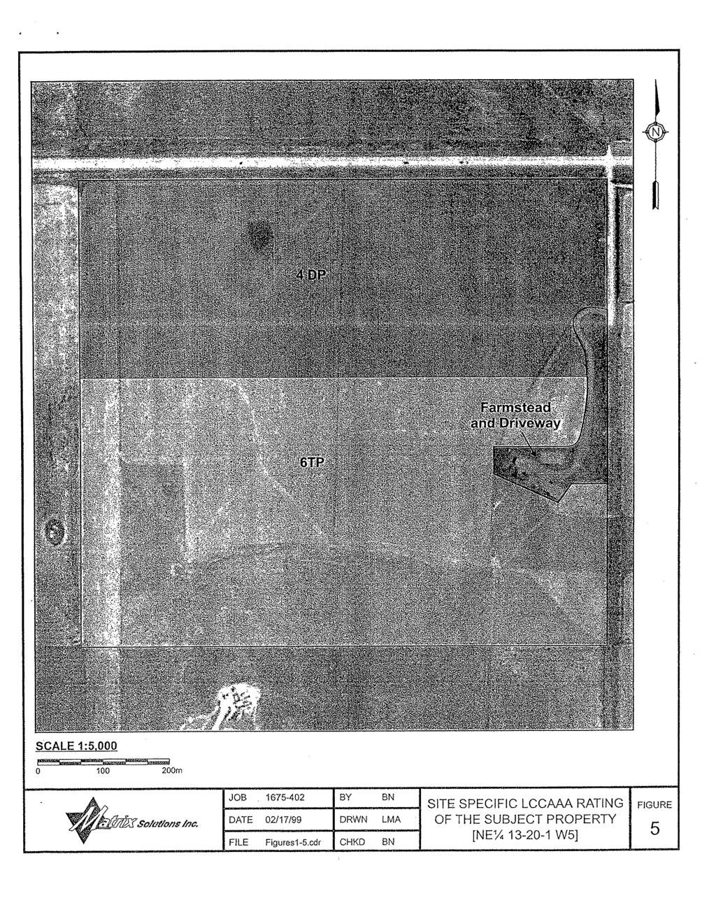
13 IBI GROUP Lorne and Leanne Read SUNDANCE TRAIL AREA STRUCTURE PLAN - AMENDMENT GENERAL PHYSICAL DESCRIPTION The Plan Area gently slopes downward from the west side of the quarter section, and the land concentrates from all sides to the southeast corner of the quarter section. As per the Agrologist report (attached as Appendix C) the north half of the Plan area is comprised of 2-5% slopes and the south half of the quarter section is comprised of 6-9% slopes. The Agrologist report also indicated that all of these slopes converge towards the southeast corner of the quarter section where the lowest point in the quarter section has been identified. Within the undeveloped lands, vegetation is comprised of grassland in the southern portion of the quarter section. A portion of the Plan Area has been cultivated with little success. The Developer no longer wishes to farm this land, as it is a very expensive process due to excessive stoniness, with little chance of success. The Agrologist report completed for the Sundance Trail confirms the low agricultural capability of the subject lands with soil ratings ranging from Class 4 to Class 6. The vegetation types and general use of the Phase II lands can be seen in Exhibit 5.0 Plan Area with Aerial Photography 3. PLAN GOALS AND OBJECTIVES 3.1 Goals and Objectives The primary objective for the Sundance Trail Area Structure Plan is to provide a planning framework for the development of the NE ¼ Sec W5M. The overall objectives of the Sundance Trail Area Structure Plan are as follows: a. To create an attractive multi-lot development comprised of twelve (12) Country Residential lots and a Municipal Reserve and walkway system within Phase I, and five (5) Country Residential lots, a Municipal Reserve parcel and an agricultural balance within Phase II. b. To provide an open space walkway system that will enhance pedestrian movement and provide linkages to the Municipal Reserves. c. To register a restrictive covenant on all Country Residential lots within the Plan Area, to ensure that the lots are developed responsibly with continuity. d. To ensure that the development conforms to the goals and objectives of the M.D. of Foothills No. 31 Municipal Development Plan and Land Use Bylaw. e. To create an affordable family environment geared towards community and safety. 3.2 Principles of Development COMMUNITY ASSOCIATION The Developer has created a self-governing community association, comprised of the newly created lot owners of the Plan Area. Membership in this community association is predetermined, as each new lot owner within Phase II will be bound to this association by way of a restrictive covenant, which will be placed on the title of each new lot. The community association will be responsible for the maintenance and liability of the walkway system. Additionally, the Developer on behalf of the community association has approached the M.D. of Foothills No. 31 and has been granted the right to lease the Phase I Municipal Reserve parcel for the community. The community association has undertaken the liability and financial responsibility for the care of the Municipal Reserve within Phase I. The Developer may apply to April 2008 Page 5
 Lot 3 ±1.85 ha (±4.57 Ac.) UTILITY R/W (021 4220) 2 021 4219 Lot 1 ±1.72 ha (±4.25 Ac.) ±14.14 ±170.83 Lot 1 ±2.06 ha (±5.")
14 ( ) UTILITY R/W UTILITY R/W ( ) ± ± ±31.65 ±56.50 ±99.58 ±99.93 ±99.93 ±48.05 ±99.90 ±99.91 ±99.93 ± ± ± HI SERVICE ROAD Lot 2 ±2.05 ha (±5.07 Ac.) Lot 3 ±1.85 ha (±4.57 Ac.) UTILITY R/W ( ) Lot 1 ±1.72 ha (±4.25 Ac.) ±14.14 ± Lot 1 ±2.06 ha (±5.09 Ac.) ± ±30.00 UTILITY R/W ( ) ± Lot 4 ±1.89 ha (±4.67 Ac.) Lot 2 ±1.80 ha (±4.45 Ac.) Lot 4 ±1.77 ha (±4.37 Ac.) Lot 5 ±1.85 ha (±4.57 Ac.) PHASE 1 UTILITY R/W ( ) Lot 12 MR MUNICIPAL RESERVE ±2.84 ha (±7.02 Ac.) ± Lot 3 ±1.72 ha (±4.25 Ac.) ± ±31.31 ±31.41 ± Lot 5 ±1.77 ha (±4.38 Ac.) ± Lot 6 ±1.85 ha (±4.57 Ac.) Lot 7 ±2.08 ha (±5.14 Ac.) Lot 11 ±1.62 ha (±4.00 Ac.) Lot 10 ±1.91 ha (±4.72 Ac.) MR ±1.01 ha (±2.50 Ac.) ± Proposed Approach ±47.23 ± Remainder ±12.23 ha (±30.21 Ac.) Proposed Approach PHASE Lot 8 ±2.02 ha (±4.99 Ac.) Lot 9 ±2.02 ha (±4.99 Ac.) ± LOT 4 LOT 5 Subject Lands Phase 1 Phase 2 Sundance Trail Area Structure Plan NE ¼ Sec W5M Aerial Photo Exhibit 5.0 1:5000 April SUB-01.dwg Source:
15 IBI GROUP Lorne and Leanne Read SUNDANCE TRAIL AREA STRUCTURE PLAN - AMENDMENT lease the Municipal Reserve parcel within Phase II, however approval to lease the Phase II Municipal Reserve parcel will be at the discretion of Council RESTRICTIVE COVENANT A restrictive covenant will be placed on the title of each new Country Residential lot. This restrictive covenant will require each new landowner to build their dwelling according to Architectural Guidelines. The Architectural Guidelines, to be administered by IBI Group, include details such as: Building Envelopes Site Requirements Housing Forms Building Materials Fencing Landscaping Construction Requirements, and Use of Land (such as garbage disposal, storage, restricted burning, permitted animals and the landowner s responsibility regarding animals). In addition, the restrictive covenant will require that each new landowner participate in, and contribute to a community association, comprised of all landowners of the Plan Area. 4. DEVELOPMENT PROPOSAL 4.1 The Plan Concept With an amendment to the Sundance Trail Area Structure Plan, the Developer will add to the project initiated in The existing service road, built by the Developer as a condition of approval for Phase I, provides safe access to Phase II. The ongoing development of services within the Town of Okotoks, and the proximity of the Plan Area to the Town make this area suitable for further development. As noted in the objectives, this amended Plan proposes to add to the existing twelve (12) lot development. Phases I and II will be controlled by Architectural Guidelines, which will be registered on the title of each new lot as a restrictive covenant. Country Residential lots in Phase I range from 4.00 ± acres to 5.10 ± acres. The Country Residential lots in Phase II will range from 4.25 ± acres to 5.09 ± acres, leaving an Agricultural balance of ± acres. The Municipal Reserves will be joined to all lots of the Plan Area by a ten meter (10 m) walkway system. Sundance Trail will be a development that will create an affordable family environment geared towards community and safety within the M.D. of Foothills No Land Use Components Phase I was completed in 2002, creating eleven new country residential lots, a Municipal Reserve, a walkway system, and incorporated an existing country residential lot. The Phase II Country Residential lots, Municipal Reserve and walkway system will be developed and incorporated into Phase I. April 2008 Page 6
16 IBI GROUP Lorne and Leanne Read SUNDANCE TRAIL AREA STRUCTURE PLAN - AMENDMENT COUNTRY RESIDENTIAL DISTRICT This Area Structure Plan is compatible and consistent with the provisions of the Municipal Development Plan and the Land Use Bylaw. Currently the Phase II lands carry an Agricultural District (A) designation in the M.D. of Foothills No. 31 Land Use Bylaw. In order to proceed with the subdivision of Phase II, the land will first need to be redesignated to Country Residential District (CR). The Country Residential policies are as follows: a) The minimum lot size shall not be less than 3.00 acres; b) A Restrictive Covenant outlining architectural controls shall apply to all Country Residential lots within Phase II AGRICULTURAL DISTRICT Phase II will result in a remainder of ± acres with an Agricultural District designation. The agricultural parcel within Phase II must meet the requirements of the municipal legislation for the M.D. of Foothills No MUNICIPAL RESERVE Under Section 666(1) of the Municipal Government Act, Council may require the owner of a parcel of land that is subject to a subdivision to provide land for Municipal Reserve or provide money in place of land. Phase I created a 7.01-acre Municipal Reserve as required by legislation. The Municipal Reserve has been located in the centre of the Plan Area to provide access to the landowners of the Plan Area and to act as a main focal area within the development. As indicated in Section of this plan, the Sundance Trail Community Association has applied to lease the Municipal Reserve, from the M.D. of Foothills No. 31. The Community Association maintains and cares for the Municipal Reserve based on their recreational pursuits. Phase II will create an additional Municipal Reserve parcel consisting of approximately 2.5± acres. The following policies apply to the Municipal Reserve: a. Lands indicated in Exhibit 4.0 Plan Area as Municipal Reserve are to be dedicated to the Municipal District of Foothills No. 31 for use as outlined in the Municipal Government Act; b. The Municipal Reserve requirements for the balance lands of Phase II will be deferred via caveat to the balance parcel. c. At the discretion of Council, the Sundance Trail Community Association could lease the Municipal Reserve from the Municipality for agricultural pursuits or development such as but not limited to a park, playground, or community facility WALKWAY SYSTEM The walkway system in Phase II will be a continuation of the existing walkway system created in Phase I. The walkway system will be ten meters (10 m) wide to allow for a range of recreational pursuits, such as horseback riding. The walkway system has been designed to allow all lots to the access to the Municipal Reserves via the walkway system. This walkway system will be landscaped by the Developer to ensure both visual and recreational variation to the users by placing shrubs, trees, and other features along the walkway system. Additionally, the Developer will fence the walkways, establishing the boundary of the walkway system from the lots within the Plan Area, and providing a buffer to Highway 7. April 2008 Page 7
17 IBI GROUP Lorne and Leanne Read SUNDANCE TRAIL AREA STRUCTURE PLAN - AMENDMENT To ensure that the walkway system is cared for in the future, a community association has been created, involving all landowners of the Plan Area. This community association collects funds for the care and continuous maintenance of the walkway system. The policies that apply to the walkway system are as follows: a. The walkway system will be constructed by the Developer, and shall be maintained by the Sundance Trail Community Association; b. The walkway system is in addition to the lands provided for municipal reserve and does not form any part of the required 10% municipal reserve dedication; c. With the exception of maintenance or emergency vehicles, no motorized vehicles will be permitted within the walkway system; d. Public liability for the walkway system will be the responsibility of the Sundance Trail Community Association. 4.3 Phasing This development will be competed in two phases. Phase I included the development and servicing of Lots 1-12, Block 2, Plan , including the Municipal Reserve, the internal road providing access to these twelve (12) lots, and the Phase I walkway system. Additionally Phase I included work regarding the external road system as per Alberta Transportation s recommendations. Phase II will create five (5) new country residential lots, a Municipal Reserve parcel, and will add to the walkway system created in Phase I. The boundaries of Phase I and II are identified in Exhibit 6.0 Phasing. If further development phases are considered within the Sundance Trail Plan Area an amendment to this Area Structure Plan will be required. 4.4 Density As indicated in the M.D. of Foothills No. 31 Municipal Development Plan, a quarter section may contain a total maximum density of thirty-two (32) lots or one (1) lot or unit per five (5) acres under a Country Residential designation. Within the NE Sec W5M there were twelve (12) Country Residential lots registered in Phase I. Phase II will add an additional five (5) Country Residential lots to the quarter section with a remainder of 32.89± acres. The total developable area of the parent parcel including the lands required for road widening was acres, equating to a maximum density of thirty-one (31) lots. The total density for the Plan Area, Phases I and II will be seventeen (17) Country Residential lots and one (1) Agricultural lot. The total density ratio is therefore 1:8.81 or one lot per 8.81 acres. Based on this density the Sundance Trail Area Structure Plan meets the requirements of the M.D. of Foothills No. 31 Municipal Development Plan for Country Residential parcels. TABLE 1: DENSITY TABLE Total Number of Country Residential Lots Phase I Phase II Area Required for Road (Hwy. 7) Total Parent Parcel Area 12 lots 6 lots 18 lots Total Area 86.23± acres 59.33± acres 12.95± acres on Road Plan Total Density 1 lot per 7.19 acres 1 lot per 9.89 acres ± acres 1 lot per 8.81 acres April 2008 Page 8
18 ( ) UTILITY R/W UTILITY R/W ( ) ± ± ±31.65 ±56.50 ±99.58 ±99.93 ±99.93 ±48.05 ±99.90 ±99.91 ±99.93 ± ± ± HI SERVICE ROAD Lot 2 ±2.05 ha (±5.07 Ac.) Lot 3 ±1.85 ha (±4.57 Ac.) UTILITY R/W ( ) Lot 1 ±1.72 ha (±4.25 Ac.) ±14.14 ± Lot 1 ±2.06 ha (±5.09 Ac.) ± ±30.00 UTILITY R/W ( ) ± Lot 4 ±1.89 ha (±4.67 Ac.) Lot 2 ±1.80 ha (±4.45 Ac.) Lot 4 ±1.77 ha (±4.37 Ac.) Lot 5 ±1.85 ha (±4.57 Ac.) PHASE 1 UTILITY R/W ( ) Lot 12 MR MUNICIPAL RESERVE ±2.84 ha (±7.02 Ac.) ± Lot 3 ±1.72 ha (±4.25 Ac.) ± ±31.31 ±31.41 ± Lot 5 ±1.77 ha (±4.38 Ac.) ± Lot 6 ±1.85 ha (±4.57 Ac.) Lot 7 ±2.08 ha (±5.14 Ac.) Lot 11 ±1.62 ha (±4.00 Ac.) Lot 10 ±1.91 ha (±4.72 Ac.) MR ±1.01 ha (±2.50 Ac.) ± Proposed Approach ±47.23 ±47.23 PHASE Remainder ±12.23 ha (±30.21 Ac.) Proposed Approach Lot 8 ±2.02 ha (±4.99 Ac.) Lot 9 ±2.02 ha (±4.99 Ac.) ± LOT 4 LOT 5 Subject Lands Phase 1 Phase 2 Sundance Trail Area Structure Plan NE ¼ Sec W5M Phasing Plan Exhibit 6.0 1:5000 April SUB-01.dwg Source:
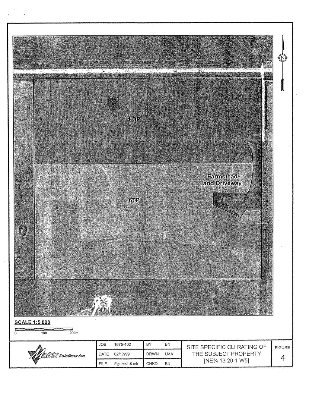
19 IBI GROUP Lorne and Leanne Read SUNDANCE TRAIL AREA STRUCTURE PLAN - AMENDMENT 4.5 Impact on Adjacent Lands By utilizing a design that incorporates topography, the existing structures and the external road system, the Developer will reduce the impact the Plan Area will have on the adjacent lands. Additionally, the Developer plans to minimize the impact on adjacent lands through proper storm water management and architectural controls. The lands to the north of the Plan Area will be minimally impacted, if at all, due to the buffer created by Highway 7. To the south, southwest, and southeast of the Plan Area multi-lot subdivisions have already been approved. The land to the west of the Plan Area has been subdivided, with one (1) lot already removed from the parent quarter section. The lands to the east will have an improved and safer access situation from Highway 7, via the service road built for Sundance Trail; furthermore the architectural controls will identify building sites that reduce the visual impact of the new parcels in relation to the existing residences. The Developer will take the proper measures to ensure that the Plan Area does not impact the adjacent landowners in a negative way. In this respect, the Plan Area has been designed to fit in with existing character of the area. Additionally, groundwater tests and percolation testing have been completed for the quarter section and a storm water management plan will be completed, as a condition of approval and if required by Council, to ensure that the Plan Area will not affect adjacent landowners. 4.6 Environmental Considerations Wildlife is not abundant in this area and the quarter section does not contain features that are typically popular to wildlife. The Developer will strive to complete this subdivision with minimal impact on the environment. The initial steps that have been taken to ensure that this occurs are the completion of various studies, such as a groundwater study and percolation testing. Additionally an Agrologist report has been completed, and a storm water management plan will be completed at the request of Council, as a condition of approval. Explanations and a summary of these studies are listed below and attached in the Appendix of this document GROUNDWATER STUDY For the development of Phase I, Groundwater Exploration & Research Ltd. completed a preliminary groundwater study in December 1999, to address the feasibility of finding sufficient volumes of groundwater to sustain 20 lots in the NE ¼ Sec W5M. A copy of this study is attached as Appendix D. Groundwater Exploration & Research Limited utilized information from Alberta Environmental Protection s groundwater database file to undertake this study. A total of 35 well records were available for review from the surrounding eight-quarter sections of land. The information provided by Groundwater Exploration & Research Ltd. shows that the water resources in the area could support a minimum of twenty (20) lots. The Groundwater Supply Evaluation was updated in March 2005 with the review of two (2) new wells that were drilled in the Phase II area. The intention of Phase II is to provide a well on each new parcel, however the updated report concluded that one (1) of the new wells would be capable of supplying water to service up to ten (10) lots. Furthermore, the new well would not interfere with any household users, licensees, or traditional agricultural users who existed at the time the report was prepared. The report also concluded that historical non-pumping water levels do not yield a concern for any significant decline in the water level. The updated report has also been attached as Appendix D. Section of this Plan refers to the policies for the development of water wells within Sundance Trail. April 2008 Page 9
20 IBI GROUP Lorne and Leanne Read SUNDANCE TRAIL AREA STRUCTURE PLAN - AMENDMENT PERCOLATION TESTING (SHALLOW SUBSURFACE CONDITIONS) To ensure that the lots are suitable for standard sewage disposal field tile systems the Developer completed shallow subsurface testing for Phases I and II. The Phase I testing (report completed in January of 2000) indicated that only one (1) lot within Phase I would require a raised septic field of 1.0 metre. The Phase II testing (report completed in March 2005) indicated that all test locations are suitable for standard sewage disposal field tile systems. The reports completed by Almor Testing Services Limited are attached as Appendix E. Policies regarding sewage disposal for Sundance Trail are located in Section of this Plan AGROLOGIST REPORT Previous landowners who have farmed this quarter section have deemed it incapable of agricultural production due to excessive stoniness resulting in damage to the machinery far outweighing any income from the sale of crops taken off this quarter section. On February 11, 1999, Matrix Solutions Inc. was hired to assess the potential for arable agriculture on the NE ¼ Sec W5M. This report is attached as Appendix C. The site specification evaluation of the subject property resulted in a rating of Class 4DP for 65 acres across the north half of the quarter section and a rating of Class 6TP for 90 acres across the south half of the quarter section (see Figure 3). The remaining 5.0 ± acres on the quarter section comprise the farmstead and driveway. As indicated in the Agrologist report, the NE ¼ Sec W5M is not suitable for agriculture because of excessive stoniness. Additionally, the land does not exceed 15% slope. For these reasons, the development going on in this area and the Plan Area s close proximity to Okotoks, Country Residential development is ideal for this quarter section. 4.7 Transportation INTERNAL ROAD SYSTEM The Developer will construct a high quality road system to the M.D. of Foothills No. 31 Road Construction Standards. The following policies will apply to the internal road system: a. The speed limit on the internal road will be set at 40 km per hour; b. Construction of the internal roadways shall be the responsibility of the Developer EXTERNAL ROAD SYSTEM With regards to the external road system the following policies will apply: a. The developer shall meet all requirements of Alberta Transportation as a condition of approval. b. If required by Council, the Developer shall upgrade the service road to Municipal standards, to the location of the Phase II access point. April 2008 Page 10
21 IBI GROUP Lorne and Leanne Read SUNDANCE TRAIL AREA STRUCTURE PLAN - AMENDMENT c. Road improvement fees required by Council shall be as per the 2007 Planning Fees Schedule, noting that the Schedule states that: no municipal road improvement fee will be imposed under the following conditions: d. Council requires a developer to build, rebuild, dust control or surface a municipal road and the cost of that work exceeds the road improvement fee Subdivision Access Location A sight distance analysis was completed for the intersection of Highway 7 and Meridian Road. The results of the analysis indicated that the Meridian Road/Highway 7 intersection was not suitable when Phase I was developed. Based on the results of the sight distance analysis, the Highway 7 intersection was located as identified on Exhibit 4.0, facilitating acceptable sight distances at the new intersection constructed during Phase I. A summary of the sight distance analysis results is contained in Appendix F Subdivision Access Design Based on analysis, and upon discussion with Alberta Transportation a Type lll (a) standard at-grade intersection was required at the Phase I development stage, thereby resulting construction of the access from the Plan Area onto Highway 7. A study completed by IBI Group (attached as Appendix F) ensured that this access met all site distance requirements as per Alberta Transportation Meridian Road As per Alberta Transportation requirements, lots to the east of the Plan Area, which have gained access at the Highway 7/Meridian Road intersection, will now gain access by way of the service road. Furthermore, The MD of Foothills No. 31 will be required to make application to close a portion of Meridian Road, to prevent future access to Highway 7. Upon closure of a portion of Meridian road by the Municipality the Developer will remove the road surfacing on Meridian Road to allow the lands to be leased for pasture purposes. The road surface will only be removed in the areas where the adjacent lands do not require the surfacing for access purposes. The following policies will apply to the removal of the road surface: a. The road surfacing along Meridian Road will only be removed in those areas where it will not prevent access for the adjacent landowners; b. The road surfacing removal will be at the full expense of the Developer; c. The road surfacing removal could be subject to Municipal approval Road Widening As required as a condition of approval for Phase I a forty meter (40 m) wide strip for future road widening purposes was provided by the Developer and is identified in Exhibit 4.0 Plan Area. Alberta Transportation has indicated that should other lands within the vicinity of the Plan Area, on the south side of Highway 7, be further developed that they would require a similar setback as indicated in Exhibit Service Road As requested by Alberta Transportation, provision for the development of a continuous thirty meter (30m) service road network is provided, shown in Exhibit 4.0. This dedication will enhance the access situation for the landowner to the east and Sundance Trail by providing a safer access location from Highway 7 than the Meridian Road intersection. April 2008 Page 11
22 IBI GROUP Lorne and Leanne Read SUNDANCE TRAIL AREA STRUCTURE PLAN - AMENDMENT Highway Buffering To reduce the impact the highway may have on the subdivision, the landowners of the lots adjacent to the highway may use various buffering techniques. The restrictive covenant placed on the title of each new lot will allow landowners adjacent to the highway to landscape and place trees along the north boundary of the lots providing all setbacks from the highway and service road are met. Additionally, building envelopes for Phase II will be indicated on each lot by way of the restrictive covenant that will exceed the required setbacks from Highway 7. The Developer is also proposing a fenced walkway system that will provide further buffering and protection to all landowners of the Plan Area from Highway Servicing WATER SUPPLY The lots of the Plan Area will be serviced with potable water via individual wells, which will be drilled on each of the lots. Two (2) wells were drilled within the Phase II lands in 2005, one (1) of which has been calculated at 5.53 Cgpm, and the second that has an estimated flow rate of 4.50 Cgpm. As indicated in the reports by Groundwater Exploration & Research Ltd., sufficient water for this development will be available. Furthermore, an updated Groundwater Supply Evaluation completed in March 2005, concluded that the historical non-pumping water levels do not yield a concern for any significant decline in regional water level. Wells will be developed in accordance with the recommendations contained in the Groundwater Exploration & Research Ltd. reports attached as Appendix D. As per the Municipal Water Policy, for all applications where 6 or more lots (including existing) will be on a quarter section, proof of water must conform to the Water Act. The following policies will apply with respect to the water supply: a. The developer shall drill a water well on each new lot that meets the requirements of the Water Act as a condition of redesignation approval; In addition to the Municipal Water Policy and the Water Act, the following policy will apply to the development of Phase II: b. If the Developer fails to provide a well on each Country Residential lot within Phase II that meets the Water Act and the Municipal Water Policy the Subdivision Plan shall be amended for fewer Country Residential parcels SEWAGE DISPOSAL During the development of Phase I the Developer hired Almor Testing Services Ltd. to complete a test of the shallow subsurface conditions (attached as Appendix E). Their investigation revealed that the standard disposal field tile systems would be adequate for all locations on the NE Sec W5M, excluding one lot as indicated in the report. This lot would require a raised septic field of 1.0 meter (1 m) to be suitable for a standard disposal field tile system. In preparation of amending the Sundance Trail Area Structure Plan, the Developer hired Almor Testing Services Limited to update their original report. A total of six (6) additional percolation test holes were completed. Their investigation revealed that the test locations are suitable for standard sewage disposal field tile systems. Furthermore, it was apparent that the near surface water table will be below the vertical distance required by Alberta Environmental Protection and therefore, will meet Alberta Environmental Protection guidelines for location of disposal fields during the months of June to August, when the highest groundwater conditions are experienced. The April 2008 Page 12
23 IBI GROUP Lorne and Leanne Read SUNDANCE TRAIL AREA STRUCTURE PLAN - AMENDMENT following guidelines will apply in regards to the private sewage systems, which will be installed on each lot by the purchaser of each lot, upon an approval of this amendment. a. The Developer will meet all recommendations of Almor Testing Services Limited, stated in their report attached as Appendix E; b. The septic systems shall be properly engineered and shall meet all requirements of the Alberta Private Sewage Systems Standard of Practice STORM WATER MANAGEMENT Proper ditching and road construction along the internal road will ensure that the Plan Area drains correctly. The following policies regarding storm water management will apply to the Plan Area: a. The Developer shall complete a Storm Water Management Plan, if required by Council as a condition of approval; b. Best Management Practices (BMP s) will be implemented throughout the Plan Area. 4.9 Utilities The Developer, using the appropriate service companies for the area will provide electricity, gas, and telephone services to each lot. With regard to the utilities, the following policies will apply: a. The Developer, at their sole expense will provide all utility easements and agreements to the satisfaction of the Municipality and the utility companies; b. Shallow utilities (power, phone, gas) will be provided at the expense of the Developer Protective Services FIRE PROTECTION Fire services will be dispatched from Okotoks, which is approximately 3.0 kilometers away from the Plan Area. Easy access to the Plan Area from Okotoks will ensure minimal response times. Tanker trucks will provide water to the Plan Area in event of fire. With regards to fire protection the following policy will apply: a. The design of the subdivision shall ensure that emergency vehicles will have all weather developed access to each parcel created in the Plan Area POLICE PROTECTION Police services will be dispatched from the Okotoks detachment of the RCMP. The Plan Area s close proximity of the Plan Area to Okotoks would allow for minimum response times in the event of an emergency. April 2008 Page 13
24 IBI GROUP Lorne and Leanne Read SUNDANCE TRAIL AREA STRUCTURE PLAN - AMENDMENT 5. IMPLEMENTATION When Council adopts the amendments to the Sundance Trail Area Structure Plan, in accordance with the provisions of the Municipal Government Act the amendments will be incorporated into the existing Statutory Plan of the M.D. of Foothills No. 31. The Developer shall begin construction of Phase II upon redesignation approval to Phase II from the M.D. of Foothills No. 31 Council. J:\pre-integration\old_L\Projects\CO Lorne Read - Sundance Trail Ph. II\4.0 Report\4.1 Text-TOC\Title of Report, Date, rpt\text\read ASP April 2008.doc April 2008 Page 14
25 IBI GROUP Lorne and Leanne Read SUNDANCE TRAIL AREA STRUCTURE PLAN - AMENDMENT APPENDIX A BYLAWS OF ADOPTION April 2008
26
27
28 IBI GROUP Lorne and Leanne Read SUNDANCE TRAIL AREA STRUCTURE PLAN - AMENDMENT APPENDIX B CERTIFICATE OF TITLE April 2008
29 LAND TITLE CERTIFICATE S LINC SHORT LEGAL TITLE NUMBER ;2; LEGAL DESCRIPTION PLAN BLOCK 2 LOT 6 EXCEPTING THEREOUT ALL MINES AND MINERALS AREA: 1.85 HECTARES (4.57 ACRES) MORE OR LESS ESTATE: FEE SIMPLE ATS REFERENCE: 5;1;20;13;NE MUNICIPALITY: MUNICIPAL DISTRICT OF FOOTHILLS NO. 31 REFERENCE NUMBER: REGISTERED OWNER(S) REGISTRATION DATE(DMY) DOCUMENT TYPE VALUE CONSIDERATION /07/2003 TRANSFER OF LAND $110,000 $110,000 OWNERS RODERICK D MARTIN AND LINDA L MARTIN BOTH OF: SITE 14, BOX 25, RR#1 OKOTOKS ALBERTA T1S 1A1 AS JOINT TENANTS (DATA UPDATED BY: CHANGE OF ADDRESS ) ( CONTINUED )
30 ENCUMBRANCES, LIENS & INTERESTS PAGE 2 REGISTRATION # NUMBER DATE (D/M/Y) PARTICULARS /05/1986 UTILITY RIGHT OF WAY GRANTEE - CANADIAN WESTERN NATURAL GAS COMPANY LIMITED /10/1998 RESTRICTIVE COVENANT /12/2002 CAVEAT RE : DEVELOPMENT AGREEMENT PURSUANT TO MUNICIPAL GOVERNMENT ACT CAVEATOR - THE MUNICIPAL DISTRICT OF FOOTHILLS NO. 31. BOX 5605 HIGH RIVER ALBERTA T1V1M /12/2002 UTILITY RIGHT OF WAY GRANTEE - TELUS COMMUNICATIONS INC ST EDMONTON ALBERTA T5G2S7 GRANTEE - ATCO GAS AND PIPELINES LTD AVE SW CALGARY ALBERTA T2R1L8 GRANTEE - FORTISALBERTA INC AVE SW CALGARY ALBERTA T2S2V1 AS TO PORTION OR PLAN: (DATA UPDATED BY: CHANGE OF NAME ) /12/2002 RESTRICTIVE COVENANT /10/2003 MORTGAGE MORTGAGEE - CIBC MORTGAGES INC.. P.O. BOX 2620 CALGARY ALBERTA T2P2M7 ORIGINAL PRINCIPAL AMOUNT: $340, /07/2006 MORTGAGE MORTGAGEE - CANADIAN IMPERIAL BANK OF COMMERCE. 100 ANDERSON RD SE CALGARY ALBERTA T2J3V1 ORIGINAL PRINCIPAL AMOUNT: $430,000 ( CONTINUED )
31 PAGE 3 # TOTAL INSTRUMENTS: 007 THE REGISTRAR OF TITLES CERTIFIES THIS TO BE AN ACCURATE REPRODUCTION OF THE CERTIFICATE OF TITLE REPRESENTED HEREIN THIS 17 DAY OF APRIL, 2008 AT 02:22 P.M. ORDER NUMBER: CUSTOMER FILE NUMBER: KS *END OF CERTIFICATE* THIS ELECTRONICALLY TRANSMITTED LAND TITLES PRODUCT IS INTENDED FOR THE SOLE USE OF THE ORIGINAL PURCHASER, AND NONE OTHER, SUBJECT TO WHAT IS SET OUT IN THE PARAGRAPH BELOW. THE ABOVE PROVISIONS DO NOT PROHIBIT THE ORIGINAL PURCHASER FROM INCLUDING THIS UNMODIFIED PRODUCT IN ANY REPORT, OPINION, APPRAISAL OR OTHER ADVICE PREPARED BY THE ORIGINAL PURCHASER AS PART OF THE ORIGINAL PURCHASER APPLYING PROFESSIONAL, CONSULTING OR TECHNICAL EXPERTISE FOR THE BENEFIT OF CLIENT(S).
32 LAND TITLE CERTIFICATE S LINC SHORT LEGAL TITLE NUMBER ;2; LEGAL DESCRIPTION PLAN BLOCK 2 LOT 7 EXCEPTING THEREOUT ALL MINES AND MINERALS AREA: 2.08 HECTARES (5.14 ACRES) MORE OR LESS ESTATE: FEE SIMPLE ATS REFERENCE: 5;1;20;13;NE MUNICIPALITY: MUNICIPAL DISTRICT OF FOOTHILLS NO. 31 REFERENCE NUMBER: REGISTERED OWNER(S) REGISTRATION DATE(DMY) DOCUMENT TYPE VALUE CONSIDERATION /05/2003 TRANSFER OF LAND $373,609 SEE INSTRUMENT OWNERS BLAIR HANDEL AND GEORGIA HANDEL BOTH OF: 46 SHEEP RIVER CRESCENT OKOTOKS ALBERTA T1S 1R3 AS JOINT TENANTS ( CONTINUED )
33 ENCUMBRANCES, LIENS & INTERESTS PAGE 2 REGISTRATION # NUMBER DATE (D/M/Y) PARTICULARS /05/1986 UTILITY RIGHT OF WAY GRANTEE - CANADIAN WESTERN NATURAL GAS COMPANY LIMITED /10/1998 RESTRICTIVE COVENANT /12/2002 CAVEAT RE : DEVELOPMENT AGREEMENT PURSUANT TO MUNICIPAL GOVERNMENT ACT CAVEATOR - THE MUNICIPAL DISTRICT OF FOOTHILLS NO. 31. BOX 5605 HIGH RIVER ALBERTA T1V1M /12/2002 UTILITY RIGHT OF WAY GRANTEE - TELUS COMMUNICATIONS INC ST EDMONTON ALBERTA T5G2S7 GRANTEE - ATCO GAS AND PIPELINES LTD AVE SW CALGARY ALBERTA T2R1L8 GRANTEE - FORTISALBERTA INC AVE SW CALGARY ALBERTA T2S2V1 AS TO PORTION OR PLAN: (DATA UPDATED BY: CHANGE OF NAME ) /12/2002 RESTRICTIVE COVENANT /09/2007 MORTGAGE MORTGAGEE - THE BANK OF NOVA SCOTIA. 201 SOUTHRIDGE DR OKOTOKS ALBERTA T1S1B2 ORIGINAL PRINCIPAL AMOUNT: $750,000 ( CONTINUED )
34 PAGE 3 # TOTAL INSTRUMENTS: 006 THE REGISTRAR OF TITLES CERTIFIES THIS TO BE AN ACCURATE REPRODUCTION OF THE CERTIFICATE OF TITLE REPRESENTED HEREIN THIS 17 DAY OF APRIL, 2008 AT 02:22 P.M. ORDER NUMBER: CUSTOMER FILE NUMBER: KS *END OF CERTIFICATE* THIS ELECTRONICALLY TRANSMITTED LAND TITLES PRODUCT IS INTENDED FOR THE SOLE USE OF THE ORIGINAL PURCHASER, AND NONE OTHER, SUBJECT TO WHAT IS SET OUT IN THE PARAGRAPH BELOW. THE ABOVE PROVISIONS DO NOT PROHIBIT THE ORIGINAL PURCHASER FROM INCLUDING THIS UNMODIFIED PRODUCT IN ANY REPORT, OPINION, APPRAISAL OR OTHER ADVICE PREPARED BY THE ORIGINAL PURCHASER AS PART OF THE ORIGINAL PURCHASER APPLYING PROFESSIONAL, CONSULTING OR TECHNICAL EXPERTISE FOR THE BENEFIT OF CLIENT(S).
35 LAND TITLE CERTIFICATE S LINC SHORT LEGAL TITLE NUMBER ;2; LEGAL DESCRIPTION PLAN BLOCK 2 LOT 2 EXCEPTING THEREOUT ALL MINES AND MINERALS AREA: 2.05 HECTARES (5.07 ACRES) MORE OR LESS ESTATE: FEE SIMPLE ATS REFERENCE: 5;1;20;13;NE MUNICIPALITY: MUNICIPAL DISTRICT OF FOOTHILLS NO. 31 REFERENCE NUMBER: REGISTERED OWNER(S) REGISTRATION DATE(DMY) DOCUMENT TYPE VALUE CONSIDERATION /08/2003 TRANSFER OF LAND $350,817 CASH & MORTGAGE OWNERS JANICE BROADLEY OF SITE 14, BOX 26, RR 1 OKOTOKS ALBERTA T1S 1A1 (DATA UPDATED BY: ) (DATA UPDATED BY: CHANGE OF ADDRESS ) ENCUMBRANCES, LIENS & INTERESTS REGISTRATION NUMBER DATE (D/M/Y) PARTICULARS /05/1986 UTILITY RIGHT OF WAY GRANTEE - CANADIAN WESTERN NATURAL GAS COMPANY ( CONTINUED )
36 ENCUMBRANCES, LIENS & INTERESTS PAGE 2 REGISTRATION # NUMBER DATE (D/M/Y) PARTICULARS LIMITED /10/1998 RESTRICTIVE COVENANT /12/2002 CAVEAT RE : DEVELOPMENT AGREEMENT PURSUANT TO MUNICIPAL GOVERNMENT ACT CAVEATOR - THE MUNICIPAL DISTRICT OF FOOTHILLS NO. 31. BOX 5605 HIGH RIVER ALBERTA T1V1M /12/2002 UTILITY RIGHT OF WAY GRANTEE - TELUS COMMUNICATIONS INC ST EDMONTON ALBERTA T5G2S7 GRANTEE - ATCO GAS AND PIPELINES LTD AVE SW CALGARY ALBERTA T2R1L8 GRANTEE - FORTISALBERTA INC AVE SW CALGARY ALBERTA T2S2V1 AS TO PORTION OR PLAN: (DATA UPDATED BY: CHANGE OF NAME ) /12/2002 RESTRICTIVE COVENANT /08/2003 MORTGAGE MORTGAGEE - CIBC MORTGAGES INC.. P.O. BOX 2620 CALGARY ALBERTA T2P2M7 ORIGINAL PRINCIPAL AMOUNT: $266, /08/2003 BUILDER'S LIEN LIENOR - E & M PLUMBING (1998) LTD A ST SE HIGH RIVER ALBERTA T1V1G6 AGENT - MARILYN K ROTH AMOUNT: $11, /08/2003 BUILDER'S LIEN ( CONTINUED )
37 ENCUMBRANCES, LIENS & INTERESTS PAGE 3 REGISTRATION # NUMBER DATE (D/M/Y) PARTICULARS LIENOR - CVITANOVICH HOLDING LTD.. C/O LOW, GLENN & CARD AVE NE CALGARY ALBERTA T1Y6L4 AGENT - THOMAS F GLENN AMOUNT: $18, /08/2003 BUILDER'S LIEN LIENOR ALBERTA LTD.. C/O A GEORGE DEARING PROFESSIONAL CORPORATION 103, 14-2 AVE SE HIGH RIVER ALBERTA T1V1G4 AGENT - MIGUEL LEIVA AMOUNT: $1,764 WAGES /08/2003 BUILDER'S LIEN LIENOR - JOSE HECTOR ROJAS C/O A GEORGE DEARING PROFESSIONAL CORPORTION #103, 14-2ND AVENUE S.E. HIGH RIVER ALBERTA T1V1G4 AMOUNT: $1,292 WAGES /08/2003 BUILDER'S LIEN LIENOR - CLASSIC KITCHENS & CABINETS LIMITED. ATTN:STEPEHN CARTER-EDWARDS C/O GOWLING LAFLEUR HENDERSON 1400,700 2 ST SW CALGARY ALBERTA T2P4V5 AGENT - SALIM G KANJI AMOUNT: $10, /08/2003 BUILDER'S LIEN LIENOR - G. GOSS & SON CONSTRUCTION LTD.. C/O A GEORGE DEARING PROFESSIONAL CORPORATION #103, 14-2ND AVE. S.E. HIGH RIVER ALBERTA T1V1G4 AGENT - WILLIAM ROSS AMOUNT: $3, /08/2003 BUILDER'S LIEN ( CONTINUED )
38 ENCUMBRANCES, LIENS & INTERESTS PAGE 4 REGISTRATION # NUMBER DATE (D/M/Y) PARTICULARS LIENOR - REGAL BUILDING MATERIALS LTD D-6 STREET SE CALGARY ALBERTA T2H2M8 AGENT - JAMES AUCOIN AMOUNT: $4, /08/2003 BUILDER'S LIEN LIENOR - ROY GIBSON CONTRACTING LTD.. C/O A. GEORGE DEARING PROFESSIONAL CORPORATION 103, 14-2 AVE SE HIGH RIVER ALBERTA T1V1G4 AGENT - BEVERLY JOAN GIBSON AMOUNT: $1, /09/2003 BUILDER'S LIEN LIENOR - CUSTOM ELECTRIC LTD.. C/O DAVID F. YOUNGGREN OF DUNPHY BEST BLOCKSOM 2100, 777-8TH AVE SW CALGARY ALBERTA T2P3R5 AGENT - DAVID F YOUNGGREN AMOUNT: $10, /02/2004 CERTIFICATE OF LIS PENDENS AFFECTS INSTRUMENT: /02/2004 CERTIFICATE OF LIS PENDENS AFFECTS INSTRUMENT: /02/2004 CERTIFICATE OF LIS PENDENS AFFECTS INSTRUMENT: /02/2004 CERTIFICATE OF LIS PENDENS AFFECTS INSTRUMENT: /02/2004 CERTIFICATE OF LIS PENDENS AFFECTS INSTRUMENT: /02/2004 CERTIFICATE OF LIS PENDENS AFFECTS INSTRUMENT: /02/2004 CERTIFICATE OF LIS PENDENS AFFECTS INSTRUMENT: /02/2004 CERTIFICATE OF LIS PENDENS ( CONTINUED )
39 ENCUMBRANCES, LIENS & INTERESTS PAGE 5 REGISTRATION # NUMBER DATE (D/M/Y) PARTICULARS AFFECTS INSTRUMENT: TOTAL INSTRUMENTS: 023 THE REGISTRAR OF TITLES CERTIFIES THIS TO BE AN ACCURATE REPRODUCTION OF THE CERTIFICATE OF TITLE REPRESENTED HEREIN THIS 17 DAY OF APRIL, 2008 AT 02:22 P.M. ORDER NUMBER: CUSTOMER FILE NUMBER: KS *END OF CERTIFICATE* THIS ELECTRONICALLY TRANSMITTED LAND TITLES PRODUCT IS INTENDED FOR THE SOLE USE OF THE ORIGINAL PURCHASER, AND NONE OTHER, SUBJECT TO WHAT IS SET OUT IN THE PARAGRAPH BELOW. THE ABOVE PROVISIONS DO NOT PROHIBIT THE ORIGINAL PURCHASER FROM INCLUDING THIS UNMODIFIED PRODUCT IN ANY REPORT, OPINION, APPRAISAL OR OTHER ADVICE PREPARED BY THE ORIGINAL PURCHASER AS PART OF THE ORIGINAL PURCHASER APPLYING PROFESSIONAL, CONSULTING OR TECHNICAL EXPERTISE FOR THE BENEFIT OF CLIENT(S).
40 LAND TITLE CERTIFICATE S LINC SHORT LEGAL TITLE NUMBER ;2; LEGAL DESCRIPTION PLAN BLOCK 2 LOT 10 EXCEPTING THEREOUT ALL MINES AND MINERALS AREA: 1.91 HECTARES (4.72 ACRES) MORE OR LESS ESTATE: FEE SIMPLE ATS REFERENCE: 5;1;20;13;NE MUNICIPALITY: MUNICIPAL DISTRICT OF FOOTHILLS NO. 31 REFERENCE NUMBER: REGISTERED OWNER(S) REGISTRATION DATE(DMY) DOCUMENT TYPE VALUE CONSIDERATION /05/2003 TRANSFER OF LAND $110,000 $110,000 OWNERS DWAYNE B KRAUSS AND DIANE E KRAUSS BOTH OF: 166 WOODBEND WAY OK0T0KS ALBERTA T1S 1M1 AS JOINT TENANTS (DATA UPDATED BY: ) ( CONTINUED )
41 ENCUMBRANCES, LIENS & INTERESTS PAGE 2 REGISTRATION # NUMBER DATE (D/M/Y) PARTICULARS /05/1986 UTILITY RIGHT OF WAY GRANTEE - CANADIAN WESTERN NATURAL GAS COMPANY LIMITED /10/1998 RESTRICTIVE COVENANT /12/2002 CAVEAT RE : DEVELOPMENT AGREEMENT PURSUANT TO MUNICIPAL GOVERNMENT ACT CAVEATOR - THE MUNICIPAL DISTRICT OF FOOTHILLS NO. 31. BOX 5605 HIGH RIVER ALBERTA T1V1M /12/2002 UTILITY RIGHT OF WAY GRANTEE - TELUS COMMUNICATIONS INC ST EDMONTON ALBERTA T5G2S7 GRANTEE - ATCO GAS AND PIPELINES LTD AVE SW CALGARY ALBERTA T2R1L8 GRANTEE - FORTISALBERTA INC AVE SW CALGARY ALBERTA T2S2V1 AS TO PORTION OR PLAN: (DATA UPDATED BY: CHANGE OF NAME ) /12/2002 RESTRICTIVE COVENANT /02/2004 MORTGAGE MORTGAGEE - CANADIAN IMPERIAL BANK OF COMMERCE. 300 VILLAGE LANE OKOTOKS ALBERTA T0L1T4 ORIGINAL PRINCIPAL AMOUNT: $300,000 ( CONTINUED )
42 PAGE 3 # TOTAL INSTRUMENTS: 006 THE REGISTRAR OF TITLES CERTIFIES THIS TO BE AN ACCURATE REPRODUCTION OF THE CERTIFICATE OF TITLE REPRESENTED HEREIN THIS 17 DAY OF APRIL, 2008 AT 02:22 P.M. ORDER NUMBER: CUSTOMER FILE NUMBER: KS *END OF CERTIFICATE* THIS ELECTRONICALLY TRANSMITTED LAND TITLES PRODUCT IS INTENDED FOR THE SOLE USE OF THE ORIGINAL PURCHASER, AND NONE OTHER, SUBJECT TO WHAT IS SET OUT IN THE PARAGRAPH BELOW. THE ABOVE PROVISIONS DO NOT PROHIBIT THE ORIGINAL PURCHASER FROM INCLUDING THIS UNMODIFIED PRODUCT IN ANY REPORT, OPINION, APPRAISAL OR OTHER ADVICE PREPARED BY THE ORIGINAL PURCHASER AS PART OF THE ORIGINAL PURCHASER APPLYING PROFESSIONAL, CONSULTING OR TECHNICAL EXPERTISE FOR THE BENEFIT OF CLIENT(S).
43 LAND TITLE CERTIFICATE S LINC SHORT LEGAL TITLE NUMBER ;2;12MR LEGAL DESCRIPTION PLAN BLOCK 2 LOT 12MR (MUNICIPAL RESERVE) EXCEPTING THEREOUT ALL MINES AND MINERALS AREA: 2.84 HECTARES (7.02 ACRES) MORE OR LESS ESTATE: FEE SIMPLE ATS REFERENCE: 5;1;20;13;NE MUNICIPALITY: MUNICIPAL DISTRICT OF FOOTHILLS NO. 31 REFERENCE NUMBER: REGISTERED OWNER(S) REGISTRATION DATE(DMY) DOCUMENT TYPE VALUE CONSIDERATION /12/2002 SUBDIVISION PLAN OWNERS THE MUNICIPAL DISTRICT OF FOOTHILLS NO. 31. OF BOX 5605 HIGH RIVER ALBERTA T1V 1M ENCUMBRANCES, LIENS & INTERESTS REGISTRATION NUMBER DATE (D/M/Y) PARTICULARS /05/1986 UTILITY RIGHT OF WAY GRANTEE - CANADIAN WESTERN NATURAL GAS COMPANY LIMITED. ( CONTINUED )
44 ENCUMBRANCES, LIENS & INTERESTS PAGE 2 REGISTRATION # NUMBER DATE (D/M/Y) PARTICULARS /10/1998 RESTRICTIVE COVENANT TOTAL INSTRUMENTS: 002 THE REGISTRAR OF TITLES CERTIFIES THIS TO BE AN ACCURATE REPRODUCTION OF THE CERTIFICATE OF TITLE REPRESENTED HEREIN THIS 17 DAY OF APRIL, 2008 AT 02:22 P.M. ORDER NUMBER: CUSTOMER FILE NUMBER: KS *END OF CERTIFICATE* THIS ELECTRONICALLY TRANSMITTED LAND TITLES PRODUCT IS INTENDED FOR THE SOLE USE OF THE ORIGINAL PURCHASER, AND NONE OTHER, SUBJECT TO WHAT IS SET OUT IN THE PARAGRAPH BELOW. THE ABOVE PROVISIONS DO NOT PROHIBIT THE ORIGINAL PURCHASER FROM INCLUDING THIS UNMODIFIED PRODUCT IN ANY REPORT, OPINION, APPRAISAL OR OTHER ADVICE PREPARED BY THE ORIGINAL PURCHASER AS PART OF THE ORIGINAL PURCHASER APPLYING PROFESSIONAL, CONSULTING OR TECHNICAL EXPERTISE FOR THE BENEFIT OF CLIENT(S).
45 LAND TITLE CERTIFICATE S LINC SHORT LEGAL TITLE NUMBER ;3; LEGAL DESCRIPTION PLAN BLOCK 3 LOT 2 EXCEPTING THEREOUT ALL MINES AND MINERALS AREA: HECTARES (59.33 ACRES) MORE OR LESS ESTATE: FEE SIMPLE ATS REFERENCE: 5;1;20;13;NE MUNICIPALITY: MUNICIPAL DISTRICT OF FOOTHILLS NO. 31 REFERENCE NUMBER: REGISTERED OWNER(S) REGISTRATION DATE(DMY) DOCUMENT TYPE VALUE CONSIDERATION /06/2003 TRANSFER OF LAND $465,000 NOMINAL OWNERS LORNE READ AND LEANNE READ BOTH OF: SITE 14, BOX 16, RR #1 OKOTOKS ALBERTA T1S 1A1 AS JOINT TENANTS ( CONTINUED )
46 ENCUMBRANCES, LIENS & INTERESTS PAGE 2 REGISTRATION # NUMBER DATE (D/M/Y) PARTICULARS /05/1973 UTILITY RIGHT OF WAY GRANTEE - CANADIAN WESTERN NATURAL GAS COMPANY LIMITED. "20 FT STRIP" /05/1986 UTILITY RIGHT OF WAY GRANTEE - CANADIAN WESTERN NATURAL GAS COMPANY LIMITED /10/1998 RESTRICTIVE COVENANT /12/2002 CAVEAT RE : DEVELOPMENT AGREEMENT PURSUANT TO MUNICIPAL GOVERNMENT ACT CAVEATOR - THE MUNICIPAL DISTRICT OF FOOTHILLS NO. 31. BOX 5605 HIGH RIVER ALBERTA T1V1M /03/2007 MORTGAGE MORTGAGEE - THE BANK OF NOVA SCOTIA. 721 CORNERSTONE 201 SOUTHRIDGE DR OKOTOKS ALBERTA T1S1B2 ORIGINAL PRINCIPAL AMOUNT: $750,000 TOTAL INSTRUMENTS: 005 THE REGISTRAR OF TITLES CERTIFIES THIS TO BE AN ACCURATE REPRODUCTION OF THE CERTIFICATE OF TITLE REPRESENTED HEREIN THIS 17 DAY OF APRIL, 2008 AT 02:22 P.M. ORDER NUMBER: CUSTOMER FILE NUMBER: KS *END OF CERTIFICATE* ( CONTINUED )
47 THIS ELECTRONICALLY TRANSMITTED LAND TITLES PRODUCT IS INTENDED FOR THE SOLE USE OF THE ORIGINAL PURCHASER, AND NONE OTHER, SUBJECT TO WHAT IS SET OUT IN THE PARAGRAPH BELOW. THE ABOVE PROVISIONS DO NOT PROHIBIT THE ORIGINAL PURCHASER FROM INCLUDING THIS UNMODIFIED PRODUCT IN ANY REPORT, OPINION, APPRAISAL OR OTHER ADVICE PREPARED BY THE ORIGINAL PURCHASER AS PART OF THE ORIGINAL PURCHASER APPLYING PROFESSIONAL, CONSULTING OR TECHNICAL EXPERTISE FOR THE BENEFIT OF CLIENT(S). PAGE 3
48 LAND TITLE CERTIFICATE S LINC SHORT LEGAL TITLE NUMBER ;2; LEGAL DESCRIPTION PLAN BLOCK 2 LOT 5 EXCEPTING THEREOUT ALL MINES AND MINERALS AREA: 1.85 HECTARES (4.57 ACRES) MORE OR LESS ESTATE: FEE SIMPLE ATS REFERENCE: 5;1;20;13;NE MUNICIPALITY: MUNICIPAL DISTRICT OF FOOTHILLS NO. 31 REFERENCE NUMBER: REGISTERED OWNER(S) REGISTRATION DATE(DMY) DOCUMENT TYPE VALUE CONSIDERATION /05/2003 TRANSFER OF LAND $106,000 $106,000 OWNERS HOWEY JOSEPH DUPONT OF BOX 10, SITE 9, R.R. 2 OKOTOKS ALBERTA T1S 1A ENCUMBRANCES, LIENS & INTERESTS REGISTRATION NUMBER DATE (D/M/Y) PARTICULARS /05/1986 UTILITY RIGHT OF WAY GRANTEE - CANADIAN WESTERN NATURAL GAS COMPANY LIMITED. ( CONTINUED )
49 ENCUMBRANCES, LIENS & INTERESTS PAGE 2 REGISTRATION # NUMBER DATE (D/M/Y) PARTICULARS /10/1998 RESTRICTIVE COVENANT /12/2002 CAVEAT RE : DEVELOPMENT AGREEMENT PURSUANT TO MUNICIPAL GOVERNMENT ACT CAVEATOR - THE MUNICIPAL DISTRICT OF FOOTHILLS NO. 31. BOX 5605 HIGH RIVER ALBERTA T1V1M /12/2002 UTILITY RIGHT OF WAY GRANTEE - TELUS COMMUNICATIONS INC ST EDMONTON ALBERTA T5G2S7 GRANTEE - ATCO GAS AND PIPELINES LTD AVE SW CALGARY ALBERTA T2R1L8 GRANTEE - FORTISALBERTA INC AVE SW CALGARY ALBERTA T2S2V1 AS TO PORTION OR PLAN: (DATA UPDATED BY: CHANGE OF NAME ) /12/2002 RESTRICTIVE COVENANT /07/2006 MORTGAGE MORTGAGEE - ALBERTA TREASURY BRANCHES. 122 CENTRE AVE W BOX 147 BLACK DIAMOND ALBERTA T0L0H0 ORIGINAL PRINCIPAL AMOUNT: $400,000 ( CONTINUED )
50 PAGE 3 # TOTAL INSTRUMENTS: 006 THE REGISTRAR OF TITLES CERTIFIES THIS TO BE AN ACCURATE REPRODUCTION OF THE CERTIFICATE OF TITLE REPRESENTED HEREIN THIS 17 DAY OF APRIL, 2008 AT 02:22 P.M. ORDER NUMBER: CUSTOMER FILE NUMBER: KS *END OF CERTIFICATE* THIS ELECTRONICALLY TRANSMITTED LAND TITLES PRODUCT IS INTENDED FOR THE SOLE USE OF THE ORIGINAL PURCHASER, AND NONE OTHER, SUBJECT TO WHAT IS SET OUT IN THE PARAGRAPH BELOW. THE ABOVE PROVISIONS DO NOT PROHIBIT THE ORIGINAL PURCHASER FROM INCLUDING THIS UNMODIFIED PRODUCT IN ANY REPORT, OPINION, APPRAISAL OR OTHER ADVICE PREPARED BY THE ORIGINAL PURCHASER AS PART OF THE ORIGINAL PURCHASER APPLYING PROFESSIONAL, CONSULTING OR TECHNICAL EXPERTISE FOR THE BENEFIT OF CLIENT(S).
51 IBI GROUP Lorne and Leanne Read SUNDANCE TRAIL AREA STRUCTURE PLAN - AMENDMENT APPENDIX C AGROLOGIST REPORT April 2008
52
53
54
55
56
57
58
59
60
61
62
63

64
65
66

67
68
69
70
71
72
73
74
75
76
77
78

79
80
81
82
83
84
85
86
87 IBI GROUP Lorne and Leanne Read SUNDANCE TRAIL AREA STRUCTURE PLAN - AMENDMENT APPENDIX D WATER REPORT - Original Report (Phase I) Completed December Updated Report (Phase II) Completed March 2005 April 2008
88
89
90
91
92
93
94
95
96
97
98
99
100

101

102
103
104
105
106
107
108

109

110
111
112
113
114
115
116
117
118
119
120

121
122
123
124

125
Wapiti Ridge Estates Area Structure Plan SE W5M. December Prepared For:
 SE 13-20-1 W5M December 2000 Prepared For: 393494 Alberta Limited, and The Municipal District of Foothills No. 31 Prepared By: Kristi Beunder Professional Planning Services Calgary, Alberta Ph: 201-3309
Prt. NE W5. Prepared for: Municipal District of Foothills #31. Prepared by:
 Prt. NE 22-22-3-W5 Prepared for: Municipal District of Foothills #31 Prepared by: Bowwood Land Services Inc. R.R. 1, Dewinton, Alberta T0L 0X0 Tel: 403-995-2225 Fax: 403-938-4787 " OFFICIAL COPY " ADOPTED
Conceptual Scheme SE W4
 December 2012 1. PURPOSE 1.1. The purpose of a Conceptual Scheme (CS) is as follows: a) To provide a framework for the subsequent subdivision and/or development of land within the Country Residential Policy
DEER CREEK ESTATES AREA STRUCTURE PLAN
 DEER CREEK ESTATES AREA STRUCTURE PLAN Prepared for Municipal District of Foothills No.31 Adopted May 2007 TABLE OF CONTENTS 1.0 INTRODUCTION 1.1 Context 1 1.2 Population Growth 1 1.3 Public Involvement
City of Grande Prairie Development Services Department
 City of Grande Prairie Development Services Department COUNTRYSIDE SOUTH OUTLINE PLAN Prepared by: GPEC Consulting Ltd. #202, 10712-100th Street Grande Prairie, AB Council Resolution of August 20, 2001
MINUTES OF THE MUNICIPAL PLANNING COMMISSION Tuesday, May 5, 2015 Red Deer County Council Chambers, Red Deer County Centre
 MINUTES OF THE MUNICIPAL PLANNING COMMISSION Tuesday, May 5, 2015 Red Deer County Council Chambers, Red Deer County Centre Present: Absent: Chairman Councillor P.J.R. Massier, Mayor J.J. Wood, Councillors
The Council of the Municipal District of Foothills No. 31 met at the Foothills Administration Building, High River, Alberta, for a meeting on
 The Council of the Municipal District of Foothills No. 31 met at the Foothills Administration Building, High River, Alberta, for a meeting on September 13, 2017 at 9:00 a.m. Present were Mayor L. Spilak,
Draft Zoning Changes for the 2nd Planning Board Public Hearing, January 22, 2018.
 Draft Zoning Changes for the 2nd Planning Board Public Hearing, January 22, 2018. No changes were made at the 1st Public Hearing. Proposed wording for the 1 st Public Hearing in red, eliminated text in
SUBDIVISION APPLICATION
 PLANNING AND DEVELOPMENT SERVICES 38106 Rge Rd 275, Red Deer County, AB T4S-2L9 Phone: (403) 350-2170 Fax: (403) 346-9840 For Office Use Only File # Roll # Fee Submitted Date Deemed Complete Reference
5. That the Owner shall agree that all development Blocks shown within the Draft Plan will be connected to full municipal services.
 Conditions Relating to Draft Plan of Subdivision Approval East Fonthill 26T 01014 (Draft Plan dated December 1, 2013, and revised August 28, 2014), the Town of Pelham 1. This approval applies to the Draft
Town of Beaumont Municipal Planning Commission Meeting Thursday, July at 11:00 a.m. Beaumont Town Office Council Chambers ~ AGENDA ~
 Town of Beaumont Municipal Planning Commission Meeting Thursday, July 20 2017 at 11:00 a.m. Beaumont Town Office Council Chambers FILE: 0562-M01 ~ AGENDA ~ 1. CALL TO ORDER 2. MODIFICATION TO THE AGENDA
19.12 CLUSTER RESIDENTIAL DISTRICT
 Chapter 19.12 CLUSTER RESIDENTIAL DISTRICT (Adopted 12/22/2003; Ordinance #0061970). Amended 7/3/17, Ordinance #079100. Section 19.12.010 - Declaration of Intent. The Cluster Residential District provides
SUBDIVISION AND DEVELOPMENT APPEAL BOARD AGENDA
 SUBDIVISION AND DEVELOPMENT APPEAL BOARD AGENDA January 30, 2019 ROCKY VIEW COUNTY COUNCIL CHAMBERS 262075 ROCKY VIEW POINT ROCKY VIEW COUNTY, AB T4A 0X2 A B CALL MEETING TO ORDER DEVELOPMENT APPEALS 9:00
Issue Summary Report 4.1. MUNICIPAL PLANNING COMMISSION MINUTES FEBRUARY 4, 2014 # Commission. Executive Summary
 Issue Summary Report 4.1. MUNICIPAL PLANNING COMMISSION MINUTES FEBRUARY 4, 2014 #20140130002 Meeting : February 4, 2014 Municipal Planning Commission Meeting Type : Municipal Planning Commission Presenter
NORTHGLEN ESTATES CONCEPTUAL SCHEME. MUNICIPAL DISTRICT OF ROCKY VIEW NO. 44 Department of Planning and Development
 NORTHGLEN ESTATES CONCEPTUAL SCHEME Bylaw C-5139-99, Adopted December 14, 1999 MUNICIPAL DISTRICT OF ROCKY VIEW NO. 44 Department of Planning and Development MUNICIPAL DISTRICT OF ROCKY VIEW NO. 44 BYLAW
Telecommunications Development Permit Application Package
 Telecommunications Development Permit Application Package POLICY POL#308 Title: Policy Guidelines to Evaluate Commercial Communications Facilities Legal References: Radio Communication Act Municipal Government
PLANNING SERVICES FORM 3.3 SUBDIVISION APPLICATION COMMERCIAL OR BUSINESS PURPOSES
 FOR OFFICE USE ONLY Date of Receipt File Number Fee Submitted SUBDIVISION APPLICATION COMMERCIAL OR BUSINESS PURPOSES Accepted by Please note that the information provided in these forms is crucial to
SMOKY LAKE COUNTY. Alberta Provincial Statutes. To provide a process to close a Government Road Allowance, or cancel a surveyed Road Plan.
 SMOKY LAKE COUNTY Title: Road Closure or Cancellation Policy No.: 16-03 Section: 03 Page No.: 1 of 11 E Legislation Reference: Alberta Provincial Statutes Purpose: To provide a process to close a Government
LAND USE AMENDMENT SPRINGBANK HILL (WARD 6) ELMONT DRIVE SW AND 69 STREET SW BYLAW 114D2017
 ELMONT DRIVE SW AND 69 STREET SW BYLAW 114D2017") Page 1 of 8 EXECUTIVE SUMMARY This land use amendment application proposes to redesignate and subdivide 1.15 hectares of land located within the southwest community of East Springbank to accommodate 17
Page 1 of 8 EXECUTIVE SUMMARY This land use amendment application proposes to redesignate and subdivide 1.15 hectares of land located within the southwest community of East Springbank to accommodate 17
Conceptual Scheme SE W4
 Conceptual Scheme September 2014 Conceptual Scheme 1. PURPOSE 1.1. The purpose of a Conceptual Scheme (CS) is as follows: a) To provide a framework for the subsequent subdivision and/or development of
ALC Bylaw Reviews. A Guide for Local Governments
 2018 ALC Bylaw Reviews A Guide for Local Governments ALC Bylaw Reviews A Guide for Local Governments This version published on: August 14, 2018 Published by: Agricultural Land Commission #201-4940 Canada
BYLAW C
 BYLAW C-7356-2014 7599-2016 THIS BEING WHEREAS AND WHEREAS AND WHEREAS AND WHEREAS AND WHEREAS a Bylaw of the Rocky View County in the Province of Alberta, to authorize an off-site transportation levy
-MENDOCINO COUNTY PLANNING AND BUILDING SERVICES- DIVISION OF LAND REGULATIONS TITLE 17
 ARTICLE VI -- GENERAL REGULATIONS AND PROVISIONS Sec. 17-50. Sec. 17-51 General Plan. Sec. 17-52 Lot and Block Design and Configuration. Sec. 17-53 Lot Access. Sec. 17-54 Private Roads. Sec. 17-55 Water
April 1, 2014 Municipal Planning Commission
 April 1, 2014 Municipal Planning Commission Tuesday, April 01, 2014 Start time 10:00 AM County of Grande Prairie No. 1 Community Services Building, 10808-100 Avenue, Clairmont, AB AGENDA 1. CALL TO ORDER
SUPPLEMENTARY REQUIREMENTS SPECIFIED PENALTIES FOR OFFENCES RIPARIAN SETBACK MATRIX MODEL RURAL APPROACH STANDARDS POLICY COMMUNITY STANDARDS BYLAW
 APPENDICES APPENDIX A APPENDIX B APPENDIX C APPENDIX D APPENDIX E APPENDIX F APPENDIX G APPENDIX H APPENDIX I APPENDIX J APPENDIX K SUPPLEMENTARY REQUIREMENTS TELECOMMUNICATION TOWERS CONFINED FEEDING
EXCERPTS FROM HALIFAX REGIONAL MUNICIPALITY CHARTER
 EXCERPTS FROM HALIFAX REGIONAL MUNICIPALITY CHARTER Municipal planning strategy 227 The Council may adopt a municipal planning strategy for all, or part, of the Municipality and there may be separate strategies
Belmead Neighbourhood Structure Plan
 Belmead Neighbourhood Structure Plan Office Consolidation November 2005 Prepared by: Planning and Policy Services Branch Planning and Development Department City of Edmonton Bylaw 6619 was adopted by Council
Vesting of Roads and Reserves Policy
 Vesting of Roads and Reserves Policy Adopted by Full Council 28 July 2016 Table of Contents 1. Policy Statement and Purpose...... 1 2. Issue...... 1 3. Policy...... 2 Land Subject To Interests...... 2
ARTICLE FIVE FINAL DRAFT
 ARTICLE FIVE 021218 FINAL DRAFT Sec. 503.6 Open Space Preservation Option Open Space Preservation Option Open Space Preservation developments may be approved in the AR, R-1, R-2 and R-3 zoning districts,
Guide to Preliminary Plans
 Guide to Preliminary Plans Introduction The Douglas County is committed to providing open, transparent application processes to the public. This Guide is provided to assist anyone interested in the procedures
Financial Impact Statement There are no immediate financial impacts associated with the adoption of this report.
 STAFF REPORT Planning and Development Department Subject: Application by RYC Property to rezone a portion of lands on John Murray Dr. and Megan Lynn Dr. from R2 to R3 and to enter into a Development Agreement
APPLICATION FOR SUBDIVISION APPROVAL Summary of Application Review & Approval Process and Application Form April 1, 2009
 Land Planning Branch, (K-320LP) Phone 667-8877 Fax 393-6340 APPLICATION FOR SUBDIVISION APPROVAL Summary of Application Review & Approval Process and Application Form April 1, 2009 THE SUBDIVISION APPLICATION,
REPORT ON EXCLUSION FROM THE AGRICULTURAL LAND RESERVE (ALR) FILE NO. 191/2015
 FILE NO. 191/2015") Peace River Regional District DEVELOPMENT SERVICES REPORT ON EXCLUSION FROM THE AGRICULTURAL LAND RESERVE (ALR) FILE NO. 191/2015 OWNER: Marguerite Gladysz DATE: September 1, 2015 AREA: Electoral Area
Peace River Regional District DEVELOPMENT SERVICES REPORT ON EXCLUSION FROM THE AGRICULTURAL LAND RESERVE (ALR) FILE NO. 191/2015 OWNER: Marguerite Gladysz DATE: September 1, 2015 AREA: Electoral Area
RESIDENTIAL AND RECREATIONAL
 Energy, Mines & Resources Land Management Branch 320-300 Main Street Whitehorse, Yukon Y1A 2B5 667-5215 Fax 667-3214 www.emr.gov.yk.ca RESIDENTIAL AND RECREATIONAL Lot Enlargement Policy OBJECTIVE To facilitate
File No. SL Decision No. 2008/0377. SURFACE RIGHTS ACT RSA 2000 Chapter S-24 (hereinafter the Act )
") Before: SURFACE RIGHTS ACT RSA 2000 Chapter S-24 (hereinafter the Act ) SURFACE RIGHTS BOARD (hereinafter the Board ). IN THE MATTER OF certain lands subject to a Surface Lease ( surface lease ) in the
Before: SURFACE RIGHTS ACT RSA 2000 Chapter S-24 (hereinafter the Act ) SURFACE RIGHTS BOARD (hereinafter the Board ). IN THE MATTER OF certain lands subject to a Surface Lease ( surface lease ) in the
ACCESSORY DWELLING UNITS
 ACCESSORY DWELLING UNITS LAND USE BYLAW C-4841-97 ACCESSORY DWELLING UNIT (ADU): means a subordinate dwelling unit attached to, created within or detached from the principal dwelling, single detached,
Guide to Minor Developments
 Guide to Minor Developments Introduction The Douglas County (DCD) is committed to providing open, transparent application processes to the public. This Guide is provided to assist anyone interested in
PLANNING REPORT. Lot 5, SDR Lot 6 and 7 Concession 3 Township of Normanby Municipality of West Grey County of Grey
 PLANNING REPORT Dwelling Surplus to a Farm Operation Official Plan and Zoning By-law Amendment and Consent to Sever Lot 5, SDR Lot 6 and 7 Concession 3 Township of Normanby Municipality of West Grey County
COUNTY COUNCIL MEETING AGENDA August 4, 2009 (to follow MPC Meeting)
") COUNTY COUNCIL MEETING AGENDA August 4, 2009 (to follow MPC Meeting) Page 1.0 CALL TO ORDER 2.0 APPROVAL OF AGENDA 2.1 Additional Agenda Items 3.0 MINUTES 3-8 3.1 Minutes of the regular meeting of County
COUNTY COUNCIL MEETING AGENDA August 4, 2009 (to follow MPC Meeting) Page 1.0 CALL TO ORDER 2.0 APPROVAL OF AGENDA 2.1 Additional Agenda Items 3.0 MINUTES 3-8 3.1 Minutes of the regular meeting of County
SUBDIVISION AND DEVELOPMENT REGULATION
 Province of Alberta MUNICIPAL GOVERNMENT ACT SUBDIVISION AND DEVELOPMENT REGULATION Alberta Regulation 43/2002 With amendments up to and including Alberta Regulation 188/2017 Office Consolidation Published
STAFF REPORT. Financial Impact Statement There are no immediate financial impacts associated with the adoption of this report.
 STAFF REPORT Planning and Development Department Subject: Cottage Country Unsubstantial Amendment to Development Agreement To: CAO for Planning Advisory Committee, December 13, 2016 Date Prepared: December
SUBDIVISION BY-LAW MUNICIPALITY OF THE COUNTY OF INVERNESS
 SUBDIVISION BY-LAW MUNICIPALITY OF THE COUNTY OF INVERNESS APPROVED BY COUNCIL: JUNE 15, 1998 EFFECTIVE DATE: SEPTEMBER 23, 1998 Page 2 TABLE OF CONTENTS PART 1: SHORT TITLE... 5 PART 2: INTERPRETATION...
RURAL GENERAL RG 1. PERMITTED USES DISCRETIONARY USES
 RURAL GENERAL RG PURPOSE: To protect the agricultural land base of the municipality while allowing nonagricultural developments which complement the area's economy. 1. PERMITTED USES DISCRETIONARY USES
Chapter CLUSTER RESIDENTIAL DISTRICT (Adopted 12/22/2003; Ordinance # )
") Chapter 19.12 CLUSTER RESIDENTIAL DISTRICT (Adopted 12/22/2003; Ordinance #0061970) Section 19.12.010 - Declaration of Intent. The Cluster Residential District provides minimum standards for specified
Chapter 19.12 CLUSTER RESIDENTIAL DISTRICT (Adopted 12/22/2003; Ordinance #0061970) Section 19.12.010 - Declaration of Intent. The Cluster Residential District provides minimum standards for specified
A Guide to the Municipal Planning Process in Saskatchewan
 A Guide to the Municipal Planning Process in Saskatchewan A look at the municipal development permit and the subdivision approval process in Saskatchewan May 2008 Prepared By: Community Planning Branch
R-11. REPORT ON SUBDIVISION WITHIN THE AGRICULTURAL LANDRESERVE FILE NO. 212/2017 (Simpson) PEACE RIVER REGIONAL DISTRICT DEVELOPMENT SERVICES
 PEACE RIVER REGIONAL DISTRICT DEVELOPMENT SERVICES") PEACE RIVER REGIONAL DISTRICT DEVELOPMENT SERVICES REPORT ON SUBDIVISION WITHIN THE AGRICULTURAL LANDRESERVE FILE NO. 212/2017 (Simpson) OWNER: David A. Simpson DATE: October 19, 2017 AREA: Electoral Area
PEACE RIVER REGIONAL DISTRICT DEVELOPMENT SERVICES REPORT ON SUBDIVISION WITHIN THE AGRICULTURAL LANDRESERVE FILE NO. 212/2017 (Simpson) OWNER: David A. Simpson DATE: October 19, 2017 AREA: Electoral Area
MUNICIPAL PLANNING COMMISSION AGENDA October 30, :30 AM
 Page MUNICIPAL PLANNING COMMISSION AGENDA October 30, 2018 9:30 AM 1.0 CALL TO ORDER 2.0 APPROVAL OF AGENDA 2.1 Additional Agenda Items 3.0 CONFIRMATION OF THE MINUTES 2-9 3.1 Minutes of the Municipal
1 November 13, 2013 Public Hearing APPLICANT & PROPERTY OWNER: HOME ASSOCIATES OF VIRGINIA, INC.
 1 November 13, 2013 Public Hearing APPLICANT & PROPERTY OWNER: HOME ASSOCIATES OF VIRGINIA, INC. STAFF PLANNER: Carolyn A.K. Smith REQUEST: Conditional Change of Zoning (AG-1 & AG-2 Agricultural Districts
TENTATIVE PARCEL MAP APPLICATION GUIDE TENTATIVE PARCEL MAP APPLICATION REQUIREMENTS
 TENTATIVE PARCEL MAP APPLICATION GUIDE SISKIYOU COUNTY PLANNING DIVISION 806 South Main Street, Yreka CA 96097 Phone: (530) 841-2100 / Fax: (530) 841-4076 TENTATIVE PARCEL MAP APPLICATION REQUIREMENTS
MUNICIPAL DEVELOPMENT PLAN
 MUNICIPAL DEVELOPMENT PLAN Prepared by: The Council and Planning and Development Services Bylaw No. 1414-09 adopted August 12, 2009 Amending Bylaw - 1480-12 adopted June 12, 2013 Amending Bylaw 1529-14
A. Preserve natural resources as identified in the Comprehensive Plan.
 1370.08 Conservation Residential Overlay District. Subd. 1 Findings. The City finds that the lands and resources within the Conservation Residential Overlay District are a unique and valuable resource
TOWN OF BLACKFALDS REGULAR COUNCIL MEETING REQUEST FOR DECISION TERRY TOPOLNITSKY PLANNING & DEVELOPMENT MGR
 TOWN OF BLACKFALDS REGULAR COUNCIL MEETING REQUEST FOR DECISION MEETING DATE: August 23, 2016 ORIGINATED BY: SUBJECT: TERRY TOPOLNITSKY PLANNING & DEVELOPMENT MGR Proposed Subdivision S-03-16 To subdivide
Issue Summary Report 4.1. MPC SEPTEMBER 10, 2013 MINUTES FOR APPROVAL # Commission. Executive Summary
 Issue Summary Report 4.1. MPC SEPTEMBER 10, 2013 MINUTES FOR APPROVAL #20130918003 Meeting : September 24, 2013 Municipal Planning Commission Meeting Type : Municipal Planning Commission Presenter : Donna
MUNICIPAL PLANNING COMMISSION AGENDA June 12, :30 AM
 Page MUNICIPAL PLANNING COMMISSION AGENDA June 12, 2018 9:30 AM 1.0 CALL TO ORDER 2.0 APPROVAL OF AGENDA 2.1 Additional Agenda Items 3.0 CONFIRMATION OF THE MINUTES 2-12 3.1 Minutes of the Municipal Planning
BAR NONE RANCHES AREA STRUCTURE PLAN. Ptn. NE W5M, M.D. Foothills No May 2017
 BAR NONE RANCHES AREA STRUCTURE PLAN Ptn. NE 34-20-0 W5M, M.D. Foothills No. 3 8 May 207 PREPARED FOR THE MUNICIPAL DISTRICT OF FOOTHILLS NO. 3 ADOPTED BY COUNCIL BYLAW (INSERT NUMBER) APPROVAL DATE (INSERT
POLICY AMENDMENT AND LAND USE AMENDMENT RICHMOND (WARD 8) RICHMOND ROAD SW AND 24 STREET SW BYLAWS 10P2018 AND 52D2018
 RICHMOND ROAD SW AND 24 STREET SW BYLAWS 10P2018 AND 52D2018") Page 1 of 12 EXECUTIVE SUMMARY This land use amendment proposes to redesignate two parcels of approximately 0.30 hectares ± (0.74 acres ±) located in the community of Richmond from DC Direct Control District
Page 1 of 12 EXECUTIVE SUMMARY This land use amendment proposes to redesignate two parcels of approximately 0.30 hectares ± (0.74 acres ±) located in the community of Richmond from DC Direct Control District
Special Use Permit - Planned Unit Development Checklist. Property Address:
 Special Use Permit - Planned Unit Development Checklist Special Use Permit Number. Parcel Code/s #28-11- - - Property Address: Applicant: ARTICLE VIII Ordinance Reference - Section 8.1.2 Permit Procedures:
REPORT ON SUBDIVISION WITHIN THE AGRICULTURAL LAND RESERVE (ALR) FILE NO. 075/2015
 FILE NO. 075/2015") Peace River Regional District DEVELOPMENT SERVICES REPORT ON SUBDIVISION WITHIN THE AGRICULTURAL LAND RESERVE (ALR) FILE NO. 075/2015 OWNER: Audrey LeClere DATE: April 27, 2015 AREA: Electoral Area B LEGAL:
Peace River Regional District DEVELOPMENT SERVICES REPORT ON SUBDIVISION WITHIN THE AGRICULTURAL LAND RESERVE (ALR) FILE NO. 075/2015 OWNER: Audrey LeClere DATE: April 27, 2015 AREA: Electoral Area B LEGAL:
MUNICIPAL DISTRICT OF ROCKY VIEW NO. 44 ELBOW VALLEY WEST DIRECT CONTROL DISTRICT BYLAW C
 This document has been consolidated for convenience only. A current listing of any and all amendments can be obtained from the Municpal District Office Bylaw No. Date of Approval Amendment Type Bylaw C-6042-2005
TOWN OF WHITBY REPORT RECOMMENDATION REPORT
 TOWN OF WHITBY REPORT RECOMMENDATION REPORT REPORT TO: Planning and Development Committee REPORT NO: PL 4-08 DATE OF MEETING: January 21, 2008 FILE NO(S): MI-01-07 (SW- 2002-03) PREPARED BY: Planning Department
SANTA BARBARA COUNTY ZONING ADMINISTRATOR STAFF REPORT November 20, 2015
 SANTA BARBARA COUNTY ZONING ADMINISTRATOR STAFF REPORT November 20, 2015 PROJECT: Acquistapace Tentative Parcel Map HEARING DATE: December 7, 2015 STAFF/PHONE: Dana Eady, (805) 934-6266 GENERAL INFORMATION
SUBDIVISION AND DEVELOPMENT APPEAL BOARD PARKLAND COUNTY. DATE: May 29, 2018 FILE NO.: 18-S-003
 SUBDIVISION AND DEVELOPMENT APPEAL BOARD PARKLAND COUNTY Legislative Services Parkland County Centre 53109A HWY 779 Parkland County, AB T7Z 1R1 Telephone: (780) 968-3234 Fax: (780) 968-8413 DATE: May 29,
TOTTENHAM SECONDARY PLAN
 TOTTENHAM SECONDARY PLAN AMENDMENT NO. 11 TO THE OFFICIAL PLAN OF THE TOWN OF NEW TECUMSETH The following text and schedules to the Official Plan of the Town of New Tecumseth constitute Amendment No. 11
Staff Report for Council Public Meeting
 Agenda Item 3.3 a Staff Report for Council Public Meeting Date of Meeting: April 11, 2018 Report Number: SRPRS.18.087 Department: Division: Subject: Planning and Regulatory Services Development Planning
UPPER MOUNT BETHEL TOWNSHIP NORTHAMPTON COUNTY, PENNSYLVANIA
 UPPER MOUNT BETHEL TOWNSHIP NORTHAMPTON COUNTY, PENNSYLVANIA JOINDER DEED / LOT CONSOLIDATION TOWNSHIP REVIEW PROCESS When accepting proposed Joinder Deeds / Lot Consolidations, review the Joinder Deed
SUBDIVISION Application Information
 Application Information COMPLETE THE ATTACHED APPLICATION FORM by printing clearly or filling out all of the required fields electronically. The application must be signed by the registered owner(s) of
Land Dedication (Reserves)
") Land Dedication (Reserves) This technical document is part of a series of draft discussion papers created by Municipal Affairs staff and stakeholders to prepare for the Municipal Government Act Review.
Land Dedication (Reserves) This technical document is part of a series of draft discussion papers created by Municipal Affairs staff and stakeholders to prepare for the Municipal Government Act Review.
SUBDIVISION APPLICATION CHECKLIST SKETCH PLAN PRELIMINARY PLAT FINAL PLAT
 RECEIVED STAMP SUBDIVISION APPLICATION CHECKLIST SKETCH PLAN PRELIMINARY PLAT FINAL PLAT A checklist of background information and submission requirements for processing of a sketch plan, preliminary plat
SCHEDULE 12 TO THE URBAN GROWTH ZONE. Shown on the planning scheme map as UGZ12. Kororoit Precinct Structure Plan
 SCHEDULE 12 TO THE URBAN GROWTH ZONE Shown on the planning scheme map as UGZ12. Kororoit Precinct Structure Plan 1.0 The plan Map 1 below shows the future urban structure proposed in the Kororoit Precinct
COUNTY OF BRANT DEVELOPMENT SERVICES DEPARTMENT COMMITTEE OF ADJUSTMENT. Chair and Members of the Committee of Adjustment
 COUNTY OF BRANT DEVELOPMENT SERVICES DEPARTMENT COMMITTEE OF ADJUSTMENT TO: FROM: Chair and Members of the Committee of Adjustment Ruchika Angrish, Senior Planner DATE: January 23, 2014 REPORT: CA-14-06
BEFORE THE HEARING EXAMINER FOR THURSTON COUNTY
 COUNTY COMMISSIONERS Cathy Wolfe District One Diane Oberquell District Two Robert N. Macleod District Three HEARING EXAMINER BEFORE THE HEARING EXAMINER FOR THURSTON COUNTY In the Matter of the Application
APPLICATION FOR DEVELOPMENT PERMIT General Information
 General Information COMPLETE THE ATTACHED APPLICATION FORM by printing clearly or filling out all of the required fields electronically. The application must be signed by the registered owner(s) of the
PENINSULA TOWNSHIP DONATION of DEVELOPMENT RIGHTS ORDINANCE (DDR, No. 45)
") PENINSULA TOWNSHIP DONATION of DEVELOPMENT RIGHTS ORDINANCE (DDR, No. 45) THE TOWNSHIP OF PENINSULA, GRAND TRAVERSE COUNTY, MICHIGAN ORDAINS: Section 101 General Provisions A. Title: This Ordinance shall
PENINSULA TOWNSHIP DONATION of DEVELOPMENT RIGHTS ORDINANCE (DDR, No. 45) THE TOWNSHIP OF PENINSULA, GRAND TRAVERSE COUNTY, MICHIGAN ORDAINS: Section 101 General Provisions A. Title: This Ordinance shall
Appendix A. Definitions
 Definitions 1. Terms Defined. Words contained in this are those having a special meaning relative to the purposes of this Ordinance. Words not listed in this section shall be defined by reference to: (1)
Members of the City of Brantford Committee of Adjustment. 1.0 TYPE OF REPORT Committee of Adjustment Decision Regarding an Application for Consent
 DATE: October 18 th 2017 REPORT NO. CD2017-168 TO: Members of the City of Brantford Committee of Adjustment FROM: Brandon Kashin, Current Development Planner 1.0 TYPE OF REPORT Committee of Adjustment
FINAL DRAFT 10/23/06 ARTICLE VI
 FINAL DRAFT 10/23/06 ARTICLE VI 185-41.1. Planned Residential Development A. Purpose and Intent. The purposes of the Planned Residential Development (PRD) bylaw are to maintain the rural character of Dover,
6.1 SCHEDULE OF AREA, FRONTAGE, YARD AND HEIGHT REQUIREMENTS
 SECTION 6.0 6.1 SCHEDULE OF AREA, FRONTAGE, YARD AND HEIGHT REQUIREMENTS Minimum Minimum Minimum Minimum Minimum Maximum Maximum Lot Lot Front Side Rear Height Lot District Area Front Yard Yard Yard Coverage
These can be obtained at the City s Engineering Department or on the City s website (
 Subdivision Application Guide This handout provides information on the requirements and processes for a subdivision of land. It is intended for general guidance only. Applicants should also refer to: Official
5-703 Agricultural Rural (AR) District Cluster Option. (A)
 District Cluster Option. (A)") 5-703 Agricultural Rural (AR) District Cluster Option. (A) Purpose. The purpose of the Agricultural Rural (AR) District Cluster Option is to provide for residential singlefamily detached development in
5-703 Agricultural Rural (AR) District Cluster Option. (A) Purpose. The purpose of the Agricultural Rural (AR) District Cluster Option is to provide for residential singlefamily detached development in
Fraser Neighbourhood Area Structure Plan
 Fraser Neighbourhood Area Structure Plan Bylaw 7357 Adopted October, 9 1984 Office Consolidation February 2016 Prepared by: Current Planning Branch Sustainable Development City of Edmonton Bylaw 7357 (as
UTILITY RIGHT-OF-WAY AND EASEMENT
 THE LAND TITLES ACT UTILITY RIGHT-OF-WAY AND EASEMENT I (We), Hauser Development Corp., of Buck Lake, in the Province of Alberta, Canada (hereinafter call the Grantor ) being registered owner of an estate
Public Facilities and Finance Element
 This Element of the General Plan addresses the following public facilities issues: Water Service, including both potable (drinkable) and non-potable water delivery. Sewer Service, and Financing and construction
Town of Falmouth s Four Step Design Process for Subdivisions in the Resource Conservation Zoning Overlay District
 Town of Falmouth s Four Step Design Process for Subdivisions in the Resource Conservation Zoning Overlay District All subdivisions shall be designed in accordance with the following four-step process.
The Chair called the meeting to order at 9:00 a.m. with all members present with the exception of Councillor Wright and Councillor Kissel.
 Page 1 A regular meeting of Rocky View County Council was held in the Council Chambers of the County Hall, 262075 Rocky View Point, Rocky View County, Alberta on commencing at 9:00 a.m. Present: Division
Corman Park - Saskatoon Planning District Official Community Plan
 1 Corman Park - Saskatoon Planning District Official Community Plan CONSOLIDATED: October, 2017 2 Table of Contents Bylaw Amendments... 3 Section 1: Foundations... 4 Section 2: Future Growth Sector Objectives
REPORT ON SUBDIVISION WITHIN THE AGRICULTURAL LAND RESERVE FILE NO. 220/2013
 PEACE RIVER REGIONAL DISTRICT DEVELOPMENT SERVICES REPORT ON SUBDIVISION WITHIN THE AGRICULTURAL LAND RESERVE FILE NO. 220/2013 ALL MEMBERS PARTICIPATE OWNER: Thomas and Marilyn Steward DATE: January 15,
York Neighbourhood Area Structure Plan
 York Neighbourhood Area Structure Plan Office Consolidation March 2006 Prepared by: Planning and Policy Services Branch Planning and Development Department City of Edmonton Bylaw 7064 was adopted by Council
8 May 11, 2011 Public Hearing APPLICANT:
 8 May 11, 2011 Public Hearing APPLICANT: EASY DOES IT RIDING ACADEMY, INC. PROPERTY OWNER: MALINDA SCOTT REQUEST: Conditional Use Permit (Riding Academy & Horse Boarding) STAFF PLANNER: Leslie Bonilla
4-1 TITLE 6 MOBILE HOME AND RECREATIONAL VEHICLE PARKS 4-3
 4-1 TITLE 6 MOBILE HOME AND RECREATIONAL VEHICLE PARKS 4-3 Chapter 4 RECREATIONAL VEHICLE PARKS Sec. 4-1: Sec. 4-2: Sec. 4-3: Sec. 4-4: Sec. 4-5: Sec. 4-6: Sec. 4-7: Sec. 4-8: Sec. 4-9: Sec. 4-10: Sec.
SISKIYOU COUNTY PLANNING COMMISSION STAFF REPORT March 21, 2018
 SISKIYOU COUNTY PLANNING COMMISSION STAFF REPORT March 21, 2018 NEW BUSINESS - AGENDA ITEM No. 2: JOANNE RICHARDSON TENTATIVE PARCEL MAP (TPM-17-04) APPLICANT: PROPERTY OWNER: PROJECT SUMMARY: GENERAL
COMPLETE AND SIGN LAND USE AMENDMENT APPLICATION FORM (attached) MUNICIPAL DISTRICT OF GREENVIEW NO. 16
 MUNICIPAL DISTRICT OF GREENVIEW NO. 16") LAND USE AMENDMENT APPLICATION PACKAGE Municipal District of Greenview 4806 36 Avenue, Box 1079, Valleyview AB T0H 3N0 T 780.524.7600 F 780.524.4307 Toll Free 1.866.524.7608 www.mdgreenview.ab.ca COMPLETE
LAND USE AMENDMENT APPLICATION PACKAGE Municipal District of Greenview 4806 36 Avenue, Box 1079, Valleyview AB T0H 3N0 T 780.524.7600 F 780.524.4307 Toll Free 1.866.524.7608 www.mdgreenview.ab.ca COMPLETE
PUBLIC RIGHTS OF WAY. Guidance for Planners and Developers
 PUBLIC RIGHTS OF WAY Guidance for Planners and Developers 1. Introduction Public rights of way (PROW) are significant highway assets, highly valued by local people. They are a material consideration in
PROVINCIAL SUBDIVISION REGULATIONS. Municipal Government Act
 PROVINCIAL SUBDIVISION REGULATIONS Made under Section 270 of the Municipal Government Act Chapter 18 of the Statutes of Nova Scotia, 1998 Service Nova Scotia and Municipal Relations April 1, 1999 (with
MUNICIPALITY OF THE COUNTY OF PICTOU SUBDIVISION BY-LAW. Act means the Municipal Government Act, Stats. N.S., 1998, c. 18 and amendments thereto;
 MUNICIPALITY OF THE COUNTY OF PICTOU SUBDIVISION BY-LAW SHORT TITLE 1. This by-law may be cited as the Pictou County Subdivision By-Law and shall apply to all lands within the Municipality of the County
Matt Berry Neighbourhood Structure Plan
 Matt Berry Neighbourhood Structure Plan Office Consolidation October 2011 Prepared by: Planning and Policy Services Branch Planning and Development Department City of Edmonton Bylaw 8936, was adopted by
ARTICLE 4 MAJOR SUBDIVISION/LAND DEVELOPMENT PLAN REQUIREMENTS
 ARTICLE 4 MAJOR SUBDIVISION/LAND DEVELOPMENT PLAN REQUIREMENTS SECTION 401 LAND SKETCH PLANS FOR MAJOR SUBDIVISIONS AND DEVELOPMENTS 401.1 Sketch Plan Information The following process and procedures shall
Approved 58 Unit Residential Condo Development for Sale. For Sale: Price Upon Request
 Approved 58 Unit Residential Condo Development for Sale 185 Thorpe Street Fairfield, 06824 For Sale: Price Upon Request u u u u Approved 58 Unit Residential Condo Development For Sale on 6.7 Acres in Fairfield
CANMORE UNDERMINING REVIEW REGULATION
 Province of Alberta MUNICIPAL GOVERNMENT ACT CANMORE UNDERMINING REVIEW REGULATION Alberta Regulation 114/1997 With amendments up to and including Alberta Regulation 170/2012 Office Consolidation Published
Regional District of Central Kootenay Subdivision Bylaw No. 2159, 2011
 Regional District of Central Kootenay Subdivision Bylaw No. 2159, 2011 Adopted September 2011 Page 1 of 21 TABLE OF CONTENTS PART 1 - TITLE... 2 PART 2 - PURPOSE... 2 PART 3 - APPLICATION AND ADMINISTRATION...
SCHEDULE 3 TO THE URBAN GROWTH ZONE. Shown on the planning scheme map as UGZ3 QUARRY HILLS PRECINCT STRUCTURE PLAN. 1.0 The Plan
 SCHEDULE 3 TO THE URBAN GROWTH ZONE 1.0 The Plan Shown on the planning scheme map as UGZ3 QUARRY HILLS PRECINCT STRUCTURE PLAN Map 1 to Schedule 3 to Clause 37.07 shows the Future Urban Structure for Quarry