W B WEB E B S E S R E V R I V CE C S E S FO F R O R SU S R U V R E V Y E O Y R O S
|
|
|
- Melvyn Marsh
- 5 years ago
- Views:
Transcription
1 The Council of European Geodetic Surveyors Comité de Liaison des Géomètres Européens GEOWEB WEB SERVICES FOR SURVEYORS Hanover, Germany October 2012
2 GEOWEB S.p.A. Geoweb S.p.A. was established in 1999 thanks to an initiative jointly undertaken Nazionale by the Consiglio Geometri e Geometri Laureati and Sogei S.p.A to develop and disseminate a wide range of WEB services dedicated to the Category of Professional Surveyors
3 THE ITALIAN SCENARIO
4 GEOWEB S.p.A. PRIMARY AIM TO MEET ITALIAN SURVEYORS NEEDS BY ENABLING THEM TO EASILY ACCESS ALL NECESSARY DATA IN ORDER TO CONDUCT THEIR PROFESSIONAL ACTIVITY AND TO MANAGE DEALINGS WITH THE PUBLIC ADMINISTRATION TO WORK DIRECTLY FROM THEIR OFFICES TO WORK AT ANY TIME (24/7)
5 GEOWEB S.p.A. WHAT DOES GEOWEB OFFER The portal has been developed to allow Geoweb s users to access the main services of the Land Agency Cadaster, as well as other Bodies and Institutions
6 GEOWEB S.p.A. WHAT DOES GEOWEB OFFER possibility to submit online updating proposals to the urban and rural cadastre databases (DOCFA and PREGEO) possibility to download land mapsheets for updating purposes (EDM) and to overlay the mapsheet on its corresponding aerial photo (Geo-Sit) ongoing training initiatives (Geo-Learning)
7 GEOWEB S.p.A. MAIN SERVICES CADASTRAL SURVEYS MORTGAGE REGISTRY RECORD CONSULTATION ON LINE DOCFA AND PREGEO SUBMISSION DOWNLOADING OF LAND MAPSHEETS FOR UPDATING (EDM) URBAN CADASTRAL TITLE PLANS PLANS OF BUILDING BLOCKS
8 GEOWEB S.p.A. MAIN SERVICES GEO-LEARNING GEO-SIT OVERLAYING OF MAPSHEETS ON THE AERIAL PHOTOS CHAMBER OF COMMERCE S SURVEYS P.R.A PUBLIC MOTOR REGISTRY CONSULTATIONS S.E.I DATABASE OF NATIONWIDE TENDERS AND AWARDS D.E.I BUILDING MATERIALS PRICE LIST AND TECHNO LEGISLATIVE ENCYCLOPEDIA
9 GEOWEB S.p.A. MAIN SERVICES GEOREFERENCING A SURVEYOR WITHIN THE ITALIAN TERRITORY DAILY NEWSPAPER REVIEW CONNECTION WITH THE REVENUE AGENCY S ONLINE FILING SERVICE TO SEND INCOME TAX RETURNS TEXT MESSAGING SERVICES
10 GEOWEB S.p.A THE BENEFITS THE LAND AGENCY CADASTER REACHES THE SURVEYOR S OFFICE VIRTUALLY AND MAKES IT POSSIBLE TO: the time required to arrive at the P.A. s offices queuing at the P.A. counters
11 GEOWEB S NETWORK CED GeoWeb Land Agency Cadaster Chambers of commerce Firewall DMZ P.R.A. Firewall Front-End Other databases Internet Banks Surveyors Mobile
12 GEOWEB MAKES IT POSSIBLE TO: share professional knowledge and experience comunicate in a timely way point out professional issues in a fast and reliable way identify and solve common specific problems enhance the surveyor s role within the P.A.
13 10 YEARS LATER MORE THAN USERS MORE THAN TRANSACTIONS EACH DAY (ABOUT TRANSACTIONS EACH MONTH) MORE THAN 50 MILLION TRANSACTIONS EACH YEAR CONSTANT DEVELOPMENT AND UPGRADING OF THE SERVICES PROVIDED

14 GEO SIT some examples This service allows the Surveyor to locate, calibrate and print the land mapsheed overlapped with high resolution aerial photos.

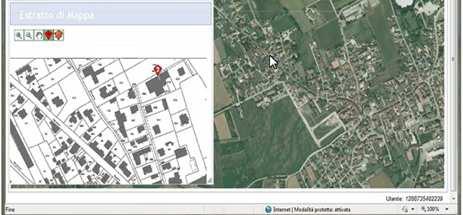
15 GEO SIT an example


16 OVERLAYING OF MAPSHEETS ON THE AERIAL PHOTOS (Geo-SIT) WEB SERVICE ENGINE:.Readings of the Optical Caracter Recognitio Trasformation algorithm from Cassini / Soldner or Gauss / Boaga to WGS84. Numerical solutions for the calculation of extreme geodesic coordinates Description


17 GEO-SIT: TO UNVEIL UNDECLARED BUILDINGS (GHOST BUILDINGS)! ALCUNI ESEMPI (G. Brachini)
18 PROSPECTIVES ONLINE TRANSMISSION TO MUNICIPALITIES OF THE BUILDING DOCUMENTATIONON ALTERNATIVE STORAGE- ELECTRONIC STORAGE OF DOCUMENTS TAX SERVICES
19 GEOWEB AND THE LAND AGENCY CADASTER Strategies HELPS THE PUBLIC ADMINISTRATION TO DESIGN SOLUTIONS DISTANCE REDUCER BETWEEN THE PROFESSIONAL CATEGORY AND THE INSTITUTION USING PROPOSALS COMPATIBLE WITH THE AIMS OF THE LAND AGENCY AND THE REQUESTS OF THE PROFESSIONAL CATEGORY
20 GEOWEB AND THE LAND AGENCY CADASTER Strategies RECEIVES FEEDBACK FROM ITS USERS MONITORS POINTS OF CONTACT WITH THE LAND OF AGENCY TO GIVE PRIORITY TO THE MOST RELEVANT ISSUES TO ESTABLISH COLLABORATIVE RELATIONSHIPS WITH THE PUBLIC ADMINISTRATION
21 GEOWEB THANK YOU FOR YOUR KIND ATTENTION
CLGE THE COUNCIL OF EUROPEAN GEODETIC SURVEYORS GEOW
 CLGE THE COUNCIL OF EUROPEAN GEODETIC SURVEYORS GEOWEB Computerised Services for the Surveyors 12 September 2009 GEOWEB S.p.A. was created for the development and the spread of computerised and automatic
Italian Cadastre and Real Estate Rights and Mortgages Registration System
 CLGE General Assembly Italian Cadastre and Real Estate Rights and Mortgages Registration System Franco Maggio Central Director Cartography, Cadastre and Real Estate Rights and Mortgages Registration System
Amalia Velasco Carlos Alonso Luis Virgos Fernando Serrano
 Inspire services of the Spanish Directorate General for Cadastre and its use to resolve an old problem of coordination between Spanish Cadastre and Land Registry. Amalia Velasco Carlos Alonso Luis Virgos
Serbia Should Have Online Cadastre for Property Like Other Countries in the Region
 Serbia Should Have Online Cadastre for Property Like Other Countries in the Region Tamara Borovcanin USAID Business Enabling Project The online real estate registry allows citizens to quickly and easily
NEW DEVELOPMENTS IN THE REAL PROPERTY REGISTER AND CADASTRE IN LITHUANIA
 NEW DEVELOPMENTS IN THE REAL PROPERTY REGISTER AND CADASTRE IN LITHUANIA Jaunius Grigas E-mail: jaunius.grigas@registrucentras.lt Verona, 2008 FUNCTIONS OF STATE ENTERPRISE CENTRE OF REGISTERS Registration
SECTOR PUBLIC CADASTRES AND REGISTERS MARKET PARTICIPANTS
 E-SERVICES TO CITIZENS, GOVERNMENT AND BUSINESSES. LITHUANIA EXPERIENCE Arvydas Bagdonavičius State Enterprise Centre of Registers Arvydas.Bagdonavicius@registrucentras.lt REGISTERS AND IS MANAGED BY THE
e-cadastre and Photo-Interpretation Technologies
 UNECE- WPLA EFFICIENT AND TRANSPARENT LAND MANAGEMENT IN ECE COUNTRIES 4 March 2010 - Baku, Azerbaijan e-cadastre and Photo-Interpretation Technologies The Italian experience as an example of Good Practice
Theme II. Customers and Services NEW PROJECTS OF THE AGENZIA DEL TERRITORIO. Marco SELLERIE
 UNITED NATIONS ECONOMIC COMMISSION FOR EUROPE COMMITTEE ON HUMAN SETTLEMENTS WORKING PARTY ON LAND ADMINISTRATION Workshop "Customer - Co-operation - Services" Vienna, Austria 12-13 September 2002 Theme
Functional system for cadastral plans
 , Republic of Macedonia Key words: Cadastre, Digital plans, Data, System SUMMARY The analysis shows that the real estate market in Republic of Macedonia grows daily. With the expansion of this market increases
LIS Development Project and Measures Proposed to Enhance Trust in the Land Administration System in Uganda
 Project for Design, Supply, Installation and Implementation of the Land Information System and Securing of Land Records (DeSILISoR) LIS Development Project and Measures Proposed to Enhance Trust in the
Report and update from Working Group A on Core Data
 JOINT UN-GGIM: EUROPE ESS MEETING ON THE INTEGRATION OF STATISTICAL AND GEOSPATIAL INFORMATION LUXEMBOURG 31 MARCH 2017 Report and update from Working Group A on Core Data François Chirié, Dominique Laurent,
The Development of the Austrian Cadastre from Documentation to an Integrated Planning and Decision Support System
 The Development of the Austrian Cadastre from Documentation to an Integrated Planning and Decision Support System WPLA - Working Party on Land Administration 15-17 October 2014, Vienna, Austria Wernher
The cadastre of buildings' energy performance - The Case Study of the Regione Lombardia
 The cadastre of buildings' energy performance - The Case Study of the Regione Lombardia Massimiliano ROMAGNOLI, Italy Key words: Energy, Environment, Law, Building. SUMMARY As part of a series of national
Progress Report on Green Paper. Dr. Paddy Prendergast. on behalf of the. IIS Commission on Land Registration
 Progress Report on Green Paper By Dr. Paddy Prendergast on behalf of the IIS Commission on Land Registration Paddy Prendergast - Chair Brendan Sweeny - Hempenstall Surveys Paul Corrigan - P Corrigan Associates
Croatian NSDI - An example of AGISEE country web-page. Vlado Cetl and Miljenko Lapaine
 Croatian NSDI - An example of AGISEE country web-page Vlado Cetl and Miljenko Lapaine Introduction 2/18 Guidelines AGISSE Country Pages should provide an overview of the situation of SDIs in the countries
PROJECT INFORMATION DOCUMENT (PID) CONCEPT STAGE Report No.: AB3229 Project Name. Land Registry and Cadastre Modernization Project Region
 CONCEPT STAGE Report No.: AB3229 Project Name. Land Registry and Cadastre Modernization Project Region") PROJECT INFORMATION DOCUMENT (PID) CONCEPT STAGE Report No.: AB3229 Project Name Land Registry and Cadastre Modernization Project Region EUROPE AND CENTRAL ASIA Sector Central government administration
PROJECT INFORMATION DOCUMENT (PID) CONCEPT STAGE Report No.: AB3229 Project Name Land Registry and Cadastre Modernization Project Region EUROPE AND CENTRAL ASIA Sector Central government administration
Directorate of Survey and Mapping NAMIBIA. Cadastral Information System. Vehupisa Kasuko Tjatindi Surveyor Directorate of Survey and Mapping NAMIBIA
 Vehupisa Kasuko Tjatindi Directorate of Survey and Mapping NAMIBIA Tel: +64 61 965000 Directorate of Survey and Mapping NAMIBIA Cadastral Information System Introduction Over the past few decades cadastral
COMPUTERIZED SYSTEM SUPPORTING DEVELOPMENT OF LAND MARKET IN GEORGIA
 COMPUTERIZED SYSTEM SUPPORTING DEVELOPMENT OF LAND MARKET IN GEORGIA S. G. TSIRAMUA, I. S. MELASHVILI Land Registration Unit of Government of Georgian, World Bank and IFAD Agriculture Development Project.
Egyptian Nationwide Title Cadastre System
 Kholoud SAAD, Egypt Key words: Cadastre, Registration, Urban, Rural, National Cadastre, Automation, reengineering. SUMMARY With growing need for integrated information, Enterprise Solutions has become
Quality Improvement to Cadastral Information in Sweden
 Gunnar BLIXT, Sweden Key words: digital cadastre, quality, cadastral index map, real property register. SUMMARY Lantmäteriet is a governmental agency which gives support for creating an efficient and sustainable
National Spatial Data Infrastructure development in Republic of Macedonia
 National Spatial Data Infrastructure development in Republic of Macedonia Sonja Dimova, state advisor for geomatics AGENCY FOR REAL ESTATE CADASTRE September 6-th, 2017, Strasbourg AREC competence for
Reliability of the Italian cadastral system data quality and improvement prospects
 Reliability of the Italian cadastral system data quality and improvement prospects Eng. Franco MAGGIO (Central Director for Cadastral, Cartographic and Land Registration Services) Eng. Arturo ANGELINI
Building Integrated Land Information Systems and Development of NSDI
 Stig JÖNSSON, Sweden Key words: Land administration, land information systems, property formation, spatial data infrastructure, Inspire, institutional cooperation SUMMARY Lantmäteriet the Swedish agency
EXPANDING AVAILABILITY OF BROADBAND ACCESS AND ADOPTION
 Single point information Ilija Kepevski Agency for Electronic Communications Regional Conference for Europe EXPANDING AVAILABILITY OF BROADBAND ACCESS AND ADOPTION 28-29 September 2015 - Budva, Montenegro
Release: 1. CPPDSM4011A List property for lease
 Release: 1 CPPDSM4011A List property for lease CPPDSM4011A List property for lease Modification History Not Applicable Unit Descriptor Unit descriptor This unit of competency specifies the outcomes required
Improvement of Effectiveness Present Developments in Hungarian Land Administration
 Improvement of Effectiveness Present Developments in Hungarian Land Administration Gyula IVÁN and András OSSKÓ, Hungary Key words: Land Administration, Cadastre, Land Registry SUMMARY New Act on Surveying
The Journey to 100% Electronic Survey. Land Information New Zealand. August 2009
 The Journey to 100% Electronic Survey and Title Lodgement Land Information New Zealand August 2009 Land Information New Zealand Established 1996 Titles, Survey, Geodetic, Electoral 12 locations 500 staff
A Website dedicated entirely to Selling Your Home!
 A Website dedicated entirely to Selling Your Home! Powered by Properties Online, Inc. 2016 Where Buyers Come From Where Buyers Found the Home they Actually Purchased Last Year. Internet 33% Agent Agent
An Overview of the eplan Journey with a Focus on the Victorian eplan 2025 Roadmap Dr Hamed Olfat
 An Overview of the eplan Journey with a Focus on the n eplan 2025 Roadmap Dr Hamed Olfat eplan Coordinator Land Use Chairman of Technical Committee ICSM eplan Working Group Outline eplan Overview ICSM
The Survey Data Model Technology A practical survey solution to generate all levels of spatial and e-governance outcomes.
 Land Governance in a Rapidly Changing Environment Annual World Bank Conference on Land and Poverty April 24 & 25, 2012 The Survey Data Model Technology A practical survey solution to generate all levels
The Cadastre of Public-law Restrictions on Landownership in Switzerland
 The Cadastre of Public-law Restrictions on Landownership in Switzerland The new official land registry information system Maurice Barbieri, CLGE President Zagreb, 26.November 2015 Utility Cadastre Seminar
Land Cadastre Act. Chapter 1. Passed RT I 1994, 74, 1324 Entry into force (except 3 which entered into force on 1.01.
 Issuer: Riigikogu Type: act In force from: 01.01.2011 In force until: 31.12.2014 Translation published: 24.10.2014 Passed 12.10.1994 RT I 1994, 74, 1324 Entry into force 08.11.1994 (except 3 which entered
USAGE OF INFORMATION AND COMMUNICATIONS TECHNOLOGY IN REAL ESTATE CONVEYANCING: ITALIAN EXPERIENCE
 USAGE OF INFORMATION AND COMMUNICATIONS TECHNOLOGY IN REAL ESTATE CONVEYANCING: ITALIAN EXPERIENCE Civil law systems has two main features in the real estate sector Real estate publicity based on Public
Procedures for the legalization and registration of buildings and building units Challenges and Problems Building cadastre in Slovenia
 Procedures for the legalization and registration of buildings and building units Challenges and Problems Building cadastre in Slovenia Edvard Mivšek M.Sc. Geodetic institut of Slovenija Pristina, 19 April
A Geocoded Cadastral Fabric as a Precondition for a Sustainable Land Management System
 A Geocoded Fabric as a Precondition for a Sustainable Land Management System Gottfried KONECNY, Germany; J.P. LAUZON, Canada; Abdul Salam MOHAMMED, India Key words: SDI,, Parcel Boundaries, GPS-GNSS, Land
Croatian SDI: a Tool for Accelerated Development of the Geo-Conscious Society
 STATE GEODETIC ADMINISTRATION Croatian SDI: a Tool for Accelerated Development of the Geo-Conscious Society Prof.Dr.Sc. Željko Bačić, Mr.Sc. Ljerka Rašić FIG Working Week 2009 - Surveyors Key Role in Accelerated
The Rent Shop Ltd. Prospectus. just a coffee a day. The finest Property Management for. the rent shop ltd licensed real estate agent
 The Rent Shop Ltd Property Management Prospectus The finest Property Management for just a coffee a day the rent shop ltd licensed real estate agent OUR Approach The Rent Shop Ltd has over 25 years experience
Spatial Data Warehouse Ltd. Cadastral Mapping INITIATIVE 1: CADASTRAL MAPPING. Version Spatial Data Warehouse Ltd. & AltaLIS Ltd.
 Spatial Data Warehouse Ltd. Initiative 1: Cadastral Mapping INITIATIVE 1: CADASTRAL MAPPING 29 P3 The SDW/AltaLIS Model Background The Government of Alberta started a mapping program, the Municipal Integrated
Results of Central European Land Knowledge Center (CELK) Activities
 Activities") Results of Central European Land Knowledge Center (CELK) Activities András OSSKÓ, Hungary Key words :CELK Center, Property Rights and Land Market Development, Networking, direct knowledge transfer SUMMARY
Results of Central European Land Knowledge Center (CELK) Activities András OSSKÓ, Hungary Key words :CELK Center, Property Rights and Land Market Development, Networking, direct knowledge transfer SUMMARY
MOUNTAIN LAKES BOARD OF REALTORS PO BOX 818 * MURPHY, NC (828) * (828)
 * (828)") MOUNTAIN LAKES BOARD OF REALTORS PO BOX 818 * MURPHY, NC 28906 (828) 837-5297 * (828) 837-1852 RULES AND REGULATIONS FOR MOUNTAIN LAKES BOARD OF REALTORS MULTIPLE LISTING SERVICE INTERNET DATA EXCHANGE
MOUNTAIN LAKES BOARD OF REALTORS PO BOX 818 * MURPHY, NC 28906 (828) 837-5297 * (828) 837-1852 RULES AND REGULATIONS FOR MOUNTAIN LAKES BOARD OF REALTORS MULTIPLE LISTING SERVICE INTERNET DATA EXCHANGE
Cadastral survey - the best way of cadastre modernization Nikola VUČIĆ & Damir ŠANTEK, Croatia
 Presented at the FIG Congress 2018, May 6-11, 2018 in Istanbul, Turkey Cadastral survey - the best way of cadastre modernization Nikola VUČIĆ & Damir ŠANTEK, Croatia LAND ADMINISTRATION IN CROATIA Two
The Multipurpose Hungarian Unified Land Registry System
 The Multipurpose Hungarian Unified Land Registry System András Osskó FIG Working Week Integrating Generation Stockholm, Sweden 14-19 June 2008 Republic of Hungary is located in Central Europe Neighbouring
Cadastre and Land Registration in Europe
 Annex A: Questionnaire 2007 for Information Resource Cadastre and Land Registration in Europe Introduction This questionnaire is based on the EuroGeographics vision document 'Cadastre and Land Registration
Cadastral data, a case of role repositioning. Alberto Donis
 IL SISTEMA INFORMATIVO CATASTALE: UNA RISORSA PER LE POLITICHE DI GOVERNO DEL TERRITORIO II Sessione Il ruolo dell informazione catastale nel governo del territorio Cadastral data, a case of role repositioning
STATE COMMITTEE OF THE REPUBLIC OF UZBEKISTAN ON LAND RESOURCES, GEODESIES, TO CARTOGRAPHY AND STATE INVENTORY
 STATE COMMITTEE OF THE REPUBLIC OF UZBEKISTAN ON LAND RESOURCES, GEODESIES, TO CARTOGRAPHY AND STATE INVENTORY Development of services in providing information on land resources and real estate, introduction
International funding projects in Republic Geodetic Authority
 International funding projects in Republic Geodetic Authority Serbia: Republic Geodetic Authority Workshop Exploring Funding Instruments for NMCA 7-8 November 2012 Republic Geodetic Authority Republic
REGIONAL GEOINFORMATION ENVIRONMENT REGIA
 REGIONAL GEOINFORMATION ENVIRONMENT REGIA Eglė Rimkienė Deputy Chief of Address Register Data Administration Division, State Enterprise Centre of Registers E-mail: Egle.Rimkiene@registrucentras.lt REGIONAL
INDIAN INSTITUTE OF TECHNOLOGY ROORKEE. Presentation on REAL TIME CADASTRAL SURVEYING SOLUTION WITH A SPECIAL IMPHESIS TO MODERN GPS TECHNOLOGY.
 INDIAN INSTITUTE OF TECHNOLOGY ROORKEE Presentation on REAL TIME CADASTRAL SURVEYING SOLUTION WITH A SPECIAL IMPHESIS TO MODERN GPS TECHNOLOGY By: Prof. Kamal Jain, Dept. of Civil Engg. IIT-Roorkee AIM
Participants of the Ministerial Meeting on Housing and Land Management on 8 October 2013 in Geneva
 Summary At its meeting on 2 April 2012, the Bureau of the Committee on Housing and Land Management of the United Nations Economic Commission for Europe agreed on the need for a Strategy for Sustainable
TOWARDS E-LAND ADMINISTRATION - ELECTRONIC PLANS OF SUBDIVISIONS IN VICTORIA
 TOWARDS E-LAND ADMINISTRATION - ELECTRONIC PLANS OF SUBDIVISIONS IN VICTORIA Mohsen Kalantari 1, Chris Lester 2, David R Boyle 3, Neil Coupar 4 1 eplan Coordinator 2 SPEAR Manager 3 Deputy Surveyor General
Meeting the Changing National Geospatial Information Needs. Palitha Udayakantha Surveyor General - Sri Lanka
 Meeting the Changing National Geospatial Information Needs Palitha Udayakantha Surveyor General - Sri Lanka Sri Lanka Location Latitude 5 55 10-9 50 6 North Longitude 79 31 19-81 52 36 East Area 65610
Country report, HUNGARY
 Country report, HUNGARY Gyula IVÁN Institute of Geodesy, Cartography & Remote Sensing (FÖMI) HUNGARY FIG Commission 7 Annual Meeting 2009 12-16 October, 2009, Kuala Lumpur, Malaysia Institute of Geodesy,
Information contained
 Government Information (Public Access) Act 2009 (GIPA Act) LPI Information Guide 1. Introduction and contents of this guide The Land and Property Information s (LPI) Information Guide tells you in general
Use of data in Ukraine for sustainable economic growth. Oleksandr Maliuk State Service of Ukraine for Geodesy, Cartography and Cadastre
 Use of data in Ukraine for sustainable economic growth Oleksandr Maliuk State Service of Ukraine for Geodesy, Cartography and Cadastre Kehl, 2017 Content of the presentation Ukraine & StateGeoCadastre:
DATR towards e-land Administration in Hungary
 DATR towards e-land Administration in Hungary Gyula IVÁN-Gábor SZABÓ-Zoltán WENINGER-Piroska Zalaba Institute of Geodesy, Cartography and Remote Sensing, Budapest, HUNGARY XXIV. FIG Congress Facing the
Cadastral services and virtual office in e-cadastre
 Cadastral services and virtual office in e-cadastre Priit Kuus Estonian Land Board October 26, 2016 Coimbra Scope of data Cadastral parcels (as of September 2016) 674 383 cadastral parcels, i.e. 97,7 %
THE XXV FIG INTERNATIONAL CONGRESS IN MALAYSIA Kuala Lumpur, Malaysia, June 2014 at Kuala Lumpur Convention Centre
 CALL FOR PAPERS TO THE XXV FIG INTERNATIONAL CONGRESS IN MALAYSIA Kuala Lumpur, Malaysia, 16 21 June 2014 at Kuala Lumpur Convention Centre Dear Friend and Colleague, It is our privilege and honour to
Designing for transparency and participation in the Hellenic Cadastral Project
 Designing for transparency and participation in the Hellenic Cadastral Project Dr. Dimitris Rokos Director of Planning and Investments, Hellenic National Cadastre and Mapping Agency S.A. Table of Contents
Property Based Land Information Systems of Turkey
 Property Based Land Information Systems of Turkey Mehmet Fatih DİRİ, Bilgehan ÖZSOY, Ünsal ERGÜN, Turkey Key words: Cadaster, Land Registry, GIS, Property, TURKEY SUMMARY The property, addition to the
Development of Mobile Cadastral Surveying System for Korean Cadastral Resurvey Project
 Development of Mobile Cadastral Surveying System for Korean Cadastral Resurvey Project Joon-Sik, KIM, Sang-Gu, KANG, Yun-Soo, CHOI, Republic of Korea Key words: Mobile Cadastral Surveying System, RTK-GPS,
SOURCES OF INFORMATION ON FIRMS
 5 Ing. Katarína Šebejová, Československá obchodná banka, a. s. Continued from 2/2004 Cadastral Real Estate Register The real estate register (or cadastre ) 1 contains a set of geodetic information and
Quality Improvement of the Real Estate Cadastre in Serbia
 , Serbia Key words: quality improvement, real estate information, quality assurance, Serbia SUMMARY The concept of cadastral modernization in the Republic of Serbia was defined in 1992, and it is being
ABSTRACT Land Administration System in Lithuania
 ABSTRACT Land Administration System in Lithuania 1. General introduction to the Lithuanian Land Administration System and State Enterprise Centre of Registers ( shortly SECR) Lithuania has established
Public Disclosure Copy
 Public Disclosure Authorized EUROPE AND CENTRAL ASIA Bosnia and Herzegovina Social, Urban, Rural and Resilience Global Practice Global Practice IBRD/IDA Specific Investment Loan FY 2013 Seq No: 10 ARCHIVED
New Developments in the Hellenic Cadastre
 New Developments in the Hellenic Cadastre Prof. M. Kavouras Vice-president Ktimatologio S.A. (Hellenic Cadastre) The Hellenic Cadastre Background The Hellenic National Cadastre Organizational and institutional
Digitalisation of the Real Property Rights Towards Spatially enabled E-Government
 Digitalisation of the Real Property Rights Towards Spatially enabled E-Government Lise Schroeder, Bent Hulegaard Jensen, Esben Munk Soerensen & Line Hvingel Istanbul, Turkey 25 june 201 Overview Introduction
LADM-based Crowdsourced 3D Cadastral Surveying Potential and Perspectives
 National Technical University Of Athens School of Rural and Surveying Engineering LADM-based Crowdsourced 3D Cadastral Surveying Potential and Perspectives Maria Gkeli, Surveying Engineer, PhD student
LAND REGISTRATION SYSTEM OF THE REPUBLIC OF CROATIA
 "On the last day of the Creation God desired to crown His work, and thus created Kornati Islands out of tears, stars and breath." (George Bernard Shaw) LAND REGISTRATION SYSTEM OF THE REPUBLIC OF CROATIA
GLOBAL GEOSPATIAL MANAGEMENT INFORMATION
 GLOBAL GEOSPATIAL MANAGEMENT INFORMATION SEOUL, KOREA 24 th to 26 th October 2011 COUNTRY REPORT - REPUBLIC OF BOTSWANA 1. INTRODUCTION 1.1. SOCIAL, ECONOMIC AND POLITICAL BACKGROUND Botswana attained
PCC Conference and Plenary Meeting "Data as a basis of the digital society March 2018, Sofia. Activity of the geodetic NGOs in Bulgaria
 PCC Conference and Plenary Meeting "Data as a basis of the digital society 13-15 March 2018, Sofia Activity of the geodetic NGOs in Bulgaria Union of Surveyors and Land Managers in Bulgaria Chamber of
Aspect of preliminary activities in the function of supporting NSDI
 Sonja DIMOVA, Republic of Macedonia Key words: e-governance, geospatial data, NSDI, INSPIRE, metadata SUMMARY The successful establishment of the NSDI in the true sense of the word cannot be performed
Integrating Electronic Platform (IPE) as a Basic Component of Cadastral System in Poland
 as a Basic Component of Cadastral System in Poland") Integrating Electronic Platform (IPE) as a Basic Component of Cadastral System in Poland Hans KNOOP, Germany and Wojciech WILKOWSKI, Poland Key words: cadastal system, cadastral objects, computerisation
Integrating Electronic Platform (IPE) as a Basic Component of Cadastral System in Poland Hans KNOOP, Germany and Wojciech WILKOWSKI, Poland Key words: cadastal system, cadastral objects, computerisation
Information contained
 Cadastral Integrity Unit Audit Survey Procedures August 2012 Table of Contents Introduction... 2 2. Objectives... 3 3. Roles, responsibilities and delegations... 4 3.1 Ethical conduct... 4 3.2 Workplace
National Rural Environmental Registry System. Bangkok May 2017
 National Rural Environmental Registry System Bangkok May 2017 GENERAL FRAMEWORK BRASILIAN LAND REGISTRY SISTEMS The implementation of an effective Cadastre (Registry) in Brazil is a historic challenge.
Integration of Public Service Procedures and Use of Cadastral Data
 Integration of Public Service Procedures and Use of Cadastral Data Signe Rudzite Head of Cadastre and Register Department The State Land Service Vilnius, 21.10.2013 Content General information Current
Key Registers in Finland and some views of Cadastre 2035
 Presented at the FIG Working Week 2016, May 2-6, 2016 in Christchurch, New Zealand Key Registers in Finland and some views of Cadastre 2035 FIG Working Week, Christchurch New Zealand May, the 3rd, 2016
Land Registers Interconnection Gabriel Sima European Commission, DG Justice and Consumers
 Land Registers Interconnection Gabriel Sima European Commission, DG Justice and Consumers Contents Context LRI Project status System implementation National establishments for land registration Electronic
Test and Implementation of DATR System in Hungary
 Test and Implementation of DATR System in Hungary, Hungary Key words: unified land registry, cadastral map, Hungary SUMMARY During the last years there has been an important development in the Hungarian
Shaping the Cadastral Infrastructure for a Digital Future
 DEPARTMENT OF LANDS PLANNING and the ENVIRONMENT Shaping the Cadastral Infrastructure for a Digital Future Craig Sandy Director Surveys Surveyor General Survey Branch NT Australia Digital Cadastral Databases
The Development Strategy for Cadastre and Land Register in Finland
 1 2 The Development Strategy for and Land in Finland Arvo Kokkonen Ministry of Agriculture and Forestry Facts and figures of Finland - land area 304 530 km² - water area 33 615 km² - total area 338 195
AREC responsibilities, data and registries and the way of their distribution
 Data as a basis of the digital society PCC, 13-15 March 2018, Sofia AREC responsibilities, data and registries and the way of their distribution Vlatko Dimovski Agency for Real Estate Cadastre (AREC) the
The Digital Cadastral Database and the Role of the Private Licensed Surveyors in Denmark
 IRISH INSTITUTE OF SURVEYORS, DUBLIN INSTITUTE OF TECHNOLOGY, 23 NOVEMBER 2005 PUBLISHED IN IIS NEWS, WINTHER 2006. The Digital Cadastral Database and the Role of the Private Licensed Surveyors in Denmark
Land Administration and Spatial Enablement Victoria s Experience. Chris McRae, Executive Director Land Victoria
 Land Administration and Spatial Enablement Victoria s Experience Chris McRae, Executive Director Land Victoria 4 th UN Land Administration Forum, October 2011 Outline About Land Victoria Land Victoria
Cadastral Map Upgrading and Layers Harmonization for the Spatial Data Infrastructure in Friuli Venezia Giulia, Italy
 Cadastral Map Upgrading and Layers Harmonization for the Spatial Data Infrastructure in Friuli Venezia Giulia, Italy A. Beinat, F. Crosilla, E. Sossai M. Basso, R. Piuzzo 2 Summary - The cadastral mapping:
MASS VALUATION DATA FOR GOVERNMENT, CITIZENS AND BUSINESS
 Permanent Committee on Cadastre in the European Union Lithuanian Presidency PCC Conference 22-23 October 2013, Vilnius MASS VALUATION DATA FOR GOVERNMENT, CITIZENS AND BUSINESS Arvydas Bagdonavičius Deputy
GAUSSCAD A WEBGIS APPLICATION FOR COLLECTING CADASTRAL DATA
 M.M. Moise GaussCAD a WebGIS Application for Collecting Cadastral Data GAUSSCAD A WEBGIS APPLICATION FOR COLLECTING CADASTRAL DATA Mihai-Mircea MOISE, S.C. GAUSS S.R.L., mihai.moise@gauss.ro Abstract:
GeoWarehouse Land Registry. Teranet Enterprises Inc.
 GeoWarehouse Land Registry Teranet Enterprises Inc. TABLE OF CONTENTS Neighoubourhood Sales... 1 Overview... 1 Find Neighbourhood Sales... 1 Neighbourhood Sales and Map... 6 Map Neighbourhood Sales...
MyCommunity Interactive web portals for real estate communities
 MyCommunity Interactive web portals for real estate communities Our simple idea To build a platform that hosts thousands of web sites and secure portals for apartment buildings, condominiums & master planned
IMPLEMENTATION OF FLEXICADASTRE IN ZAMBIA
 IMPLEMENTATION OF FLEXICADASTRE IN ZAMBIA Presented by: Simon M. Mwalimu Head of Mining Cadastre and Secretary of The Mining Advisory Committee Mining Cadastre Office-Zambia 16 th February 2009 Part A
Tradition and Innovation in Czech Cadastre. Karel Večeře Martina Hercegová Jan Kmínek Czech Office for Surveying, Mapping and Cadastre
 Tradition and Innovation in Czech Cadastre Karel Večeře Martina Hercegová Jan Kmínek Czech Office for Surveying, Mapping and Cadastre Land Registration and Cadastre History 13 th cent. Land Tables - predecessor
Establishing a Land policy reform and GPS Technology implementation in Burkina Faso
 Annual World Bank Conference on Land and Poverty 2013 Establishing a Land policy reform and GPS Technology implementation in Burkina Faso Presentation made by Moha EL-AYACHI, IAV Hassan 2, Morocco Paper
Second Land and Real Estate Registration Project. between KYRGYZ REPUBLIC. and INTERNATIONAL DEVELOPMENT ASSOCIATION
 Public Disclosure Authorized CONFORMED COPY GRANT NUMBER H380 KG Public Disclosure Authorized Financing Agreement Second Land and Real Estate Registration Project between Public Disclosure Authorized KYRGYZ
Surveyor General s Report
 Surveyor General s Report Susan F. MacGregor O.L.S. Surveyor General Mapping and Information Resources Branch Ministry of Natural Resources and Forestry Queen s Printer for Ontario, 2017 The Ministry of
CREA DDF FAQ. Q: Will creating this facility lead to another investigation from the Competition Bureau?
 CREA DDF FAQ Note: New questions and answers added in November 2012 are shown in red. Q: What is the CREA DDF? A: The CREA DDF is a data distribution facility that CREA created to enable its members to
Property is Our Business COMPANY PROFILE. Corporate Profile
 Property is Our Business COMPANY PROFILE Corporate Profile Who we are PROPERTY ONE is a leading property house founded and established in the Kingdom of Bahrain in 2008, holding commercial registration
The Multi-Purpose Information System of Real Estates in the Czech Republic. Vladimíra ŽUFANOVÁ, Czech Republic
 The Multi-Purpose Information System of Real Estates in the Czech Republic Vladimíra ŽUFANOVÁ, Czech Republic Key words: Cadastre; Land management SUMMARY The Cadastre of Real Estate and Land administration,
Universal Geo-database Connector Interface Component (UG-CIC) For Virtual Web-base GIS Server Essential For Real Estate Industry Uses
 For Virtual Web-base GIS Server Essential For Real Estate Industry Uses") Universal Geo-database Connector Interface Component (UG-CIC) For Virtual Web-base GIS Server Essential For Real Estate Industry Uses Jad Jarroush & Dr. Kobi Zaid Zaid Orniv Group L.T.D Israel kobi_z@zaidorniv.co.il
Universal Geo-database Connector Interface Component (UG-CIC) For Virtual Web-base GIS Server Essential For Real Estate Industry Uses Jad Jarroush & Dr. Kobi Zaid Zaid Orniv Group L.T.D Israel kobi_z@zaidorniv.co.il
Cadastre, innovation and tradition in taxation and real estate market
 Cadastre, innovation and tradition in taxation and real estate market relations and interactions in managing information on properties and owners elopmen Piermassimo Pavese Central Directorate for Cadastre,
Challenges for the multi purpose cadastre
 Jens RIECKEN, Markus SEIFERT, Germany Key words: Multi purpose cadastre, 3d-cadastre, land use, SDI, solar cadastre SUMMARY Over the past 30 years, with the progress of information technologies the development
IT Solutions in Supporting Rwanda Land Administration System
 Ease of Doing Business Initiative Conference 2016 Digitizing Government business Leveraging ICT to enhance the Business Environment IT Solutions in Supporting Rwanda Land Administration System Pothin MUVARA