The Cadastre of Public-law Restrictions on Landownership in Switzerland
|
|
|
- Dina Patrick
- 6 years ago
- Views:
Transcription


1 The Cadastre of Public-law Restrictions on Landownership in Switzerland The new official land registry information system Maurice Barbieri, CLGE President Zagreb, 26.November 2015 Utility Cadastre Seminar

2 Leading Surveyors Association 37 Member countries + 3 Observing members 28 EU Members States >> Surveyors Requires close cooperation FIG, YSEN, EuroGeographics, PCC European Bodies National Associations

3 Incoming Board

")
")
")
 Vice-President")


4 Executive Board Secretary-General Vasile Chiriac (MD) President Maurice Barbieri (CH) Vice-President D. Markovinović (HR) Treasurer D. Seitz (DE) Vice-President Duncan Moss (GB) Vice-President Nicolas Smith (FR) Vice-President Pekka Halme (FI) Vice-President Mairolt Kakko (ES) Vice-President SA Rudolf Kolbe (AT) IG - PARLS Clemens Kiepke (DE) FIG Young Surveyors Diana Becirevic (HR)
5 CLGE: a definition CLGE is the leading representational body for the Surveying Profession in Europe. - Promotes the Profession in the EU - Fosters its development in the Council of Europe Surveying includes Cadastral Surveying which provides security to land and property title and thus underlies the economic base of western society. Geospatial Information is now ubiquitous in our lives and the Surveyor plays a fundamental role in this field.

6 Public-law Restriction on landownership rights

7 We are surrounded by PLR 101 laws, ordinances and regulations have to be considered in everyday situations such as this (source: FACTS, )


8 Private-law rights public-law restrictions Private-law rights are agreed upon between 2 parties. Example: purchase of real estate They are recorded in the land register and are already publicly and centrally available today. Public-law restrictions come into existence through a decision by the legislator or the public administration. Example: definition of noise protection zones. They are publicly accessible in certain regions of Switzerland and a central information website is available for consultation.
9 What are public-law restrictions? Official restrictions that apply to landowners. Public interests take precedence over private interests. For example: A protection zone can be created to secure the public interests associated with the extraction of groundwater. In a land use plan the legislator can specify which kind of land use is permitted. In Switzerland there are more than 150 different public-law restrictions.

10 Land use planning

11 Distinction between land registration and public-law restrictions Land registration: in the land register, public-law restrictions are only in specific cases concerning a single plot of land PLR-cadastre: in the PLR-cadaster, public-law restrictions are officially defined for a specific area
12 The PLR-cadastre - an official information system The PLR-cadastre is the official information system relating to public-law restrictions on landownership: It is systematically structured, It contains clearly defined and officially recognised objects, It provides information about legally binding public-law restrictions that apply towards third parties, It is an officially recognised information system, It provides comprehensive and detailed information about official geodata that the Federal Council has declared to be public-law restrictions on landownership.
13 The PLR-cadastre offers numerous benefits The total value of mortgages covering landownership in Switzerland is currently more than 900 billion Swiss francs (status: 2015). In view of this, it is important to ensure that legally binding information about plots of land is provided without delay. Benefits Easy access to reliable information Greater legal certainty thanks to official information Simplified decision-making process for the public administration Users Landowners Players on the mortgage market Public administrations

14 Reliable landownership information The PLR-Cadastre reliably and conveniently lists the most important restrictions per plot of land, and the desired information can be obtained with a couple of mouse clicks. Information about public-law restrictions can be obtained by visiting the following website:

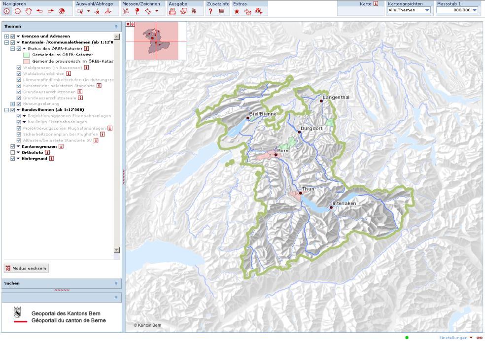
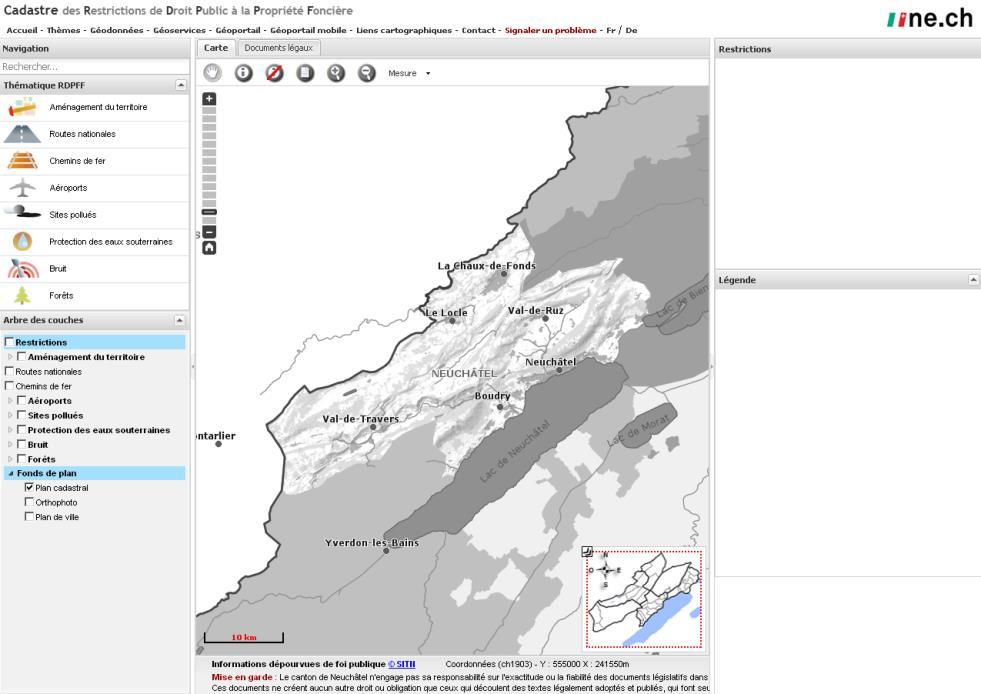
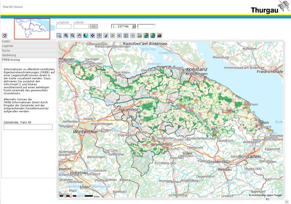
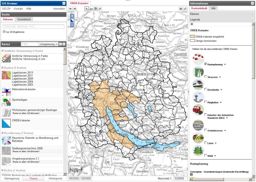
15 PLR-cadastre: a national product: Map of coverage
 are being systematically documented and centrally published.")
16 Increased legal certainty thanks to the PLR-cadastre Switzerland is one of the first countries in the world to develop a cadastre in which public-law restrictions (PLR) are being systematically documented and centrally published. This will greatly enhance legal certainty in the real estate sector.


 Forests Forest perimeters")
17 The 17 most important PLR Spatial planning Land-use planning (cantonal / municipal) Motorways Project planning zones for motorways Building lines for motorways Railways Project planning zones for railways Building lines for railways Airports Project planning zones for airports Building lines for airports Security zone plan for airports Contaminated sites Cadastre of contamined sites military sites civil airfields sites public transport sites Groundwater protection Groundwater protection zones Groundwater protection area Noise Noise sensitivity levels (in landuse zones) Forests Forest perimeters (in building zones) Forest distance lines

18 PLR-cadastre extract Reliable information in a comprehensive form about the most important PLR concerning a plot of land

19 Comprehensive information in the form of map and texts A PLR on landownership comprises: The relevant legal provisions Rulings on which the restriction and ist effects are based A map Map depicting the region in which the public-law restriction is applicable Legal bases General regulations on which rulings are based Additional information For example, name and address of the authority to contact for further information

20 Easy Access to information about PLR on landownership Search engine that greatly simplifies the serach for information Complete, reliable, comprehensible and wide-ranging information available via a central source Access to information about PLR on landownership

21 Static PLR-cadastre extract Static extract: decision-making basis Detailed information about a plot of land PDF-A1a Several pages Official document Upon request: notarisation by the authority responsible for the cadastre

22 Dynamic PLR-cadastre extract Dynamic extract: web-based visualisation Individual public law restrictions can be displayed in a variety of ways for all users via the corresponding cantonal geoportal. Multiple public law restrictions can be viewed simultaneously, i.e. overlapping one another. It is possible to view individual plots of land as well as entire regions. This makes dynamic extracts valuable aids for dealing with questions and discussing spatial issues.
23 Dynamic PLR-cadastre extracts
24 Technical access XML request and extract Standardised access via machine-to-machine communication XML request XML extract PDF extract

25 PLR cadastre - a national product : Convenient central access

26 Management of the PLR-cadastre The PLR-cadastre is jointly managed by the federal government and the cantons: The federal government defines the strategic focus of the PLR-cadastre. The cantons are responsible for organizing the management of the PLR-cadastre and for appointing the administrative bodies. There are 100% cantonal or mixed solution.

27 The Swiss cadastral system
. The documentation of PLRs potentially can improve transparency and security of landownership; if the effect is 0.")
28 The macro-economic dimension of landownership The Swiss cadastral system secures real estate values in the order of EUR 2,200 billion, of which approx. EUR 850 billion of mortgages are given out (more than EUR 100,000 per population). The documentation of PLRs potentially can improve transparency and security of landownership; if the effect is 0.1%, this would correspond to EUR 800 million.
29 Financing of the PLR cadastre The federal government and the cantons share the costs: The federal government contributes towards the management costs of the PLR-cadastre. 1/5 is distributed equally among the cantons. This portion covers the costs of the basic infrastructure, which have to be borne by all cantons, regardless of their size or the number of public law restrictions on landownership. 3/5 are distributed among the cantons based on the number of inhabitants. 1/5 is distributed among the cantons based on surface area. The updating costs have to be borne by the offices responsible for the data.


30 Eight cantons as pioneers The following pilot cantons introduced the PLR-cadastre fully or partially in 2015: The remaining cantons will be able to benefit from the experiences of the pilot cantons, and will be introducing the PLR-cadaster in the period from 2016 to the end of 2019
31 A truly worthwhile investment! The costs associated with the introduction, management and upgrading of the PLR-cadastre are offset against the benefits for: for mortgage market landowners private engineering companies the public administration amounting to around 100 million Swiss francs a year. Greater transparency of the legal situation on the mortgage market Reduced risks, and thus lower mortgage interest rates
32 Status of PLR Documentation in Europe Documentation of PLRs and possibility to overlay with cadastral landownership parcels PLRs yes, possible to overlay with CP xx PLRs yes, not possible to overlay w. CP number of PLRs documented with spatial extend PLRs no, but expected within next 5 years >60 PLRs no, not expected within next 5 years no feedback received ~60 ~7 8 < >5 2 >10
33 PLRs that have been mentioned most Types of documented PLRs in 22 countries Environment and nature protection Water protection Spatial and land-use planning zones Cultural heritage Public infrastructure corridors and zones Traffic lines and zones Forest management and protection Contamination sites, pollution Public easements, servitudes Coastal protection zones National border restrictions Sea and water public domain Biological diversity Security zones Noise Concessions Cultivation restrictions
34 Regime of data accessibility of PLRs in general open access access only for parties involved not available no feedback received Malta

35
Enhancements of the Cadastral System in Switzerland
 Enhancements of the Cadastral System in Switzerland «Cadastre of Public-Law Restrictions on Landownership» and «National Utility Cadastre» Christoph Käser Content 1. Cadastre of Public-Law Restrictions
CLGE Working for a Profession
 CLGE Working for a Profession 13-15 November 2017 PCC - Tallinn (EE) Overview Introduction The European Legislation about establishment / provision of services Proportionality check The Code of Professional
Presentation of CLGE
 Global and Regional Professional and Institutional Reforms, some actions of the CLGE Maurice Barbieri, CLGE President Presentation of CLGE Introduction Our Strategy Our Actions 1 Leading Surveyors Association
The relation between the private surveyors and the Land Registry / Cadastre
 The relation between the private surveyors and the Land Registry / Cadastre Maurice Barbieri President CLGE FIG 7 Coimbra 26 10 2016 Leading Surveyors Association 37 Member countries + 3 Observing members
CLGE Working for a Profession
 CLGE Working for a Profession Jean-Yves Pirlot, CLGE President 22-23 October 2013 PCC Conference Vilnius The European Surveyor, Today and tomorrow Jean-Yves Pirlot, CLGE President 22-23 October 2013 PCC
UTILITY CADASTER, ESTONIA
 Smeceres Smeceres UTILITY CADASTER, ESTONIA Mairolt Kakko CLGE, Association of Estonian Surveyors (EGÜ) 26.11.2015 CLGE Seminar, Zagreb LEGAL BASIS By the Estonian Building Act buildings are divided to
The Digital Cadastral Database and the Role of the Private Licensed Surveyors in Denmark
 IRISH INSTITUTE OF SURVEYORS, DUBLIN INSTITUTE OF TECHNOLOGY, 23 NOVEMBER 2005 PUBLISHED IN IIS NEWS, WINTHER 2006. The Digital Cadastral Database and the Role of the Private Licensed Surveyors in Denmark
The Swiss case: 100 years of PPP. Maurice Barbieri, President CLGE On behalf of IGS
 The Swiss case: 100 years of PPP Maurice Barbieri, President CLGE On behalf of IGS 1 Ingenieur Geometer Schweiz (IGS) We are the Association of the publicly appointed surveyors and surveyor offices in
CLGE Working for a Profession
 CLGE Working for a Profession 15. November 2017 Tallinn (ES) The public-private partnership in cadastre in Switzerland SWITZERLAND 41'290 km 2 8 million people 26 cantons ~2600 municipalities ~4.0 million
Country Report SWITZERLAND
 armasuisse Federal Office of Topography, swisstopo Country Report SWITZERLAND Dr. Daniel Steudler Swiss Annual Meeting 2013, FIG-Commission 7 22 October 2013, Yaoundé, Cameroon Basic Dimensions SWITZERLAND
Welcome Session warm welcome by BEV, celebrating 200 years of the Austrian cadastre CVC2017 supported by 7 organizations: WPLA EuroGeographics PCC EUL
 Swiss Federal Office of Topography swisstopo Federal Directorate for Cadastral Surveying Common Vision Conference 2017 Wrap-up CVC 2017 "Tradition meets Innovation" Vienna, Austria, 5/6 Oct. 2017 Dr. Daniel
Spatially Enabled Society Role of the Cadastre
 armasuisse Bundesamt für Landestopografie swisstopo Swiss Federal Directorate for Cadastral Surveying Spatially Enabled Society Role of the Cadastre XXIV FIG International Congress 2010 FIG-Task Force
The Cadastral Template 2.0, From Design to Implementation
 Abbas RAJABIFARD (Australia), Daniel Steudler (Switzerland), Ali AIEN, and Mohsen KALANTARI, Australia Key words: Cadastral Template 2.0, Cadastral Template Project, Land Administration, PCGIAP SUMMARY
The New Swiss Law on Geoinformation and the Ordinance. on thecadastre on Public Law Restrictions (4064)
") on thecadastre on Public Law Restrictions (4064) 1. INTRODUCTION 2. STARTING CONDITIONS 3. TIME FRAME 4. RESULTs OF THE WORK 5. CONTENT OF THE ACT ON GEOINFORMATION 6. CADASTRE OF THE PUBLIC-RIGHT RESTRICTIONS
on thecadastre on Public Law Restrictions (4064) 1. INTRODUCTION 2. STARTING CONDITIONS 3. TIME FRAME 4. RESULTs OF THE WORK 5. CONTENT OF THE ACT ON GEOINFORMATION 6. CADASTRE OF THE PUBLIC-RIGHT RESTRICTIONS
PROBLEMS IN REGISTRATION IN THE THIRD VERTICAL DIMENSION IN THE UNIFIED LAND REGISTRY IN HUNGARY, AND POSSIBLE SOLUTION
 3D Cadastres Technical and Legal Aspects II PROBLEMS IN REGISTRATION IN THE THIRD VERTICAL DIMENSION IN THE UNIFIED LAND REGISTRY IN HUNGARY, AND POSSIBLE SOLUTION ANDRÁS Osskó Budapest Land Office Hungary
Building Integrated Land Information Systems and Development of NSDI
 Stig JÖNSSON, Sweden Key words: Land administration, land information systems, property formation, spatial data infrastructure, Inspire, institutional cooperation SUMMARY Lantmäteriet the Swedish agency
Topographic Signs Important Context of 3D Cadastre
 STATE GEODETIC ADMINISTRATION Gruška 20,10 000 Zagreb, Croatia Delft University of Technology Faculty of Architecture and the Built Environment Department OTB GIS Technology Section Topographic Signs Important
Semantic model for Land Registers Information: Interoperability. Jesús Camy Escobar (Project Manager)
") Semantic model for Land Registers Information: Interoperability Sofia 15th March Jesús Camy Escobar (Project Manager) Vision Efficient implementation EU Regulations Qualified and complete Information from
Semantic model for Land Registers Information: Interoperability Sofia 15th March Jesús Camy Escobar (Project Manager) Vision Efficient implementation EU Regulations Qualified and complete Information from
New Danish e-cadastre and its role in the Danish e-government
 New Danish e-cadastre and its role in the Danish e-government PCC Budapest 2011 Pia Dahl Højgaard, pdh@kms.dk Cadastre and Legal Authority, National Survey and Mapping, Denmark The danish context Neighbours
EXPANDING AVAILABILITY OF BROADBAND ACCESS AND ADOPTION
 Single point information Ilija Kepevski Agency for Electronic Communications Regional Conference for Europe EXPANDING AVAILABILITY OF BROADBAND ACCESS AND ADOPTION 28-29 September 2015 - Budva, Montenegro
Use of data in Ukraine for sustainable economic growth. Oleksandr Maliuk State Service of Ukraine for Geodesy, Cartography and Cadastre
 Use of data in Ukraine for sustainable economic growth Oleksandr Maliuk State Service of Ukraine for Geodesy, Cartography and Cadastre Kehl, 2017 Content of the presentation Ukraine & StateGeoCadastre:
Key Registers in Finland and some views of Cadastre 2035
 Presented at the FIG Working Week 2016, May 2-6, 2016 in Christchurch, New Zealand Key Registers in Finland and some views of Cadastre 2035 FIG Working Week, Christchurch New Zealand May, the 3rd, 2016
Benchmarking Cadastral Systems Results of the Working Group 7.1
 Benchmarking Cadastral Systems Results of the Working Group 7.1 Jürg KAUFMANN, Switzerland Key words: ABSTRACT In 1998, FIG-Commission 7 launched three new working groups for the period 1998-2002. Working
Surveyors Qualifications
 Surveyors Qualifications Præludium Surveyors Qualifications Lars Jansson, Director Lantmäteriet Henning Elmstrøm, President DdL 1 Agenda 1. Introduction 2. Basic framework conditions for cadastral systems
Surveying in Austria. Congress Maanmittauspäivät Seinäjoki, 20 th March 2014
 Surveying in Austria Congress Maanmittauspäivät Seinäjoki, 20 th March 2014 Topics Facts, figures Organisational issues of surveying Role of the BEV Products, services The Cadastre Surveying Education
Croatian SDI: a Tool for Accelerated Development of the Geo-Conscious Society
 STATE GEODETIC ADMINISTRATION Croatian SDI: a Tool for Accelerated Development of the Geo-Conscious Society Prof.Dr.Sc. Željko Bačić, Mr.Sc. Ljerka Rašić FIG Working Week 2009 - Surveyors Key Role in Accelerated
Possible integration of Information via a system of KEY REGISTERS. IMOLA PROJECT WS 1-2nd Seminar Athens, 6th October 2014
 Possible integration of Information via a system of KEY REGISTERS IMOLA PROJECT WS 1-2nd Seminar Athens, 6th October 2014 OUTPUT QUESTIONNAIRE Questions only partly understood unclear LR belong to system
Danish Multipurpose Cadastre Experiences so Far
 Danish Multipurpose Cadastre Experiences so Far Jørgen SKRUBBELTRANG, Denmark Key words: Multipurpose cadastre, restrictions pertaining to public law, new users, top down implementation, quality of the
Agenda 25 June 2009 EXTRAORDINARY GENERAL ASSEMBLY GEOMETER EUROPAS asbl
 Brussels, 16 August 2008 Agenda 25 June 2009 EXTRAORDINARY GENERAL ASSEMBLY GEOMETER EUROPAS asbl VENUE: IDA, KALVEBOD BRYGGE 31-33, 1780 COPENHAGEN V TIMING: 13.00 18.00 HOTEL: COPENHAGEN ISLAND, KALVEBOD
Challenges for the multi purpose cadastre
 Jens RIECKEN, Markus SEIFERT, Germany Key words: Multi purpose cadastre, 3d-cadastre, land use, SDI, solar cadastre SUMMARY Over the past 30 years, with the progress of information technologies the development
The Croatian Surveyor Guaranteeing Land Property
 Croatian Chamber of Chartered Geodetic Engineers Zagreb, Croatia www.hkoig.hr The Croatian Surveyor Guaranteeing Land Property Ph. D. Danko Markovinović The Cadastral Surveyor paving the Way to the Future
The Danish Digital Cadastral Map A Tool for Land Management
 The Danish Digital Cadastral Map A Tool for Land Management Søren CHRISTENSEN, Denmark Key words: Digital cadastre, restrictions pertaining to public law, land management. ABSTRACT The establishments of
DOING BUSINESS Frederic Meunier EDBI Conference, Nairobi
 DOING BUSINESS 2016 Frederic Meunier EDBI Conference, Nairobi May 3 rd, 2016 How has the Registering Property indicator changed over time? Efficiency of land administration systems has always been measured:
Ⅱ-2. The Resurvey Project
 Presenter : JANG, Bong-Bae MLTM Ministry of land,transport and Maritime Affairs KIM, Soon-Tae KCSC Korea Cadastral Survey Corp., JANG, Bong-Bae Ⅰ. INTRODUCTION The Korean modern cadastral system was established
Incorporating Sustainable Development Objectives into ICT Enabled Land Administration Systems - Case Study Switzerland
 EXPERT GROUP MEETING ON INCORPORATING SUSTAINABLE DEVELOPMENT OBJECTIVES INTO ICT ENABLED LAND ADMINISTRATION SYSTEMS 9-11 November 2005, Centre for Spatial Data Infrastructures and Land Administration
Regulation. Deregulation
 Regulation of liberal property surveyors profession vs. Deregulation requirements for growth and competition - - - - Henning Elmstrøm President: The Danish Association of Chartered Surveyors (DdL) Torben
Standardization in the Cadastral Domain. Sub Working Group 1: Legal Aspects
 Standardization in the Cadastral Domain Sub Working Group 1: Legal Aspects Framework 10 participants 8 countries 2 sessions Updates from the different countries (mainly as to the legal aspects of cadastre)
Amie Figueiredo WPLA Secretariat Wednesday, 16 October 2014 Vienna, Raiffeisen Forum
 WPLA cooperation with related international organisations and interregional cooperation Amie Figueiredo WPLA Secretariat Wednesday, 16 October 2014 Vienna, Raiffeisen Forum International cooperation International
Cadastral Template 2003
 PCGIAP-Working Group 3 "Cadastre" FIG-Commission 7 "Cadastre and Land Management" Cadastral Template 2003 The establishment of a cadastral template is one of the objectives of Working Group 3 "Cadastre"
The Land Information System
 Country report News from the Cadastre in Finland Ari Tella 24.10.2016 FIG Commission 7 Annual Meeting, Coimbra Portugal The Land Information System NLS 2010 Land 2013 Maintenance Information Service Customers
e-land Administration in Hungary
 e-land Administration in Hungary Piroska Zalaba senior counsellor, project manager Ministry of Agriculture and Rural Development Department of Lands and Mapping FIG SEMINAR Innsbruck, 2-4 June 2004 Land
Ordinance on Official Cadastral Surveying
 English is not an official language of the Swiss Confederation. This translation is provided for information purposes only and has no legal force. Ordinance on Official Cadastral Surveying 211.432.2 of
The Boundary Concept Land Management Opportunities for Sustainable Development Provided by the Cadastre 2014 Approach. Jürg KAUFMANN, Switzerland
 The Boundary Concept Opportunities for Sustainable Development Provided by the Cadastre 2014 Approach Jürg KAUFMANN, Switzerland THE BOUNDARY CONCEPT AS A CHANCE FOR SURVEYORS OPPORTUNITIES CREATED BY
Promising times for surveyors. Land Administration in Europe -new challenges and opportunities- Formalised property rights
 Promising times for surveyors Land Administration in Europe -new challenges and opportunities- Helge Onsrud Statens kartverk Norway helge.onsrud@statkart.no From playing a key role in understanding, exploring
LAND GOVERNANCE ASSESSMENT FRAMEWORK IN SOUTH SUDAN THEMATIC AREA 4: PUBLIC PROVISION OF LAND INFORMATION
 LAND GOVERNANCE ASSESSMENT FRAMEWORK IN SOUTH SUDAN THEMATIC AREA 4: PUBLIC PROVISION OF LAND INFORMATION Theme 4: Public provision of land information Indicators Dimensions LGI-16: Completeness of registry
Cadastre and Land Registration A System currently experiencing modernization in ROMANIA
 NATIONAL AGENCY FOR CADASTRE AND LAND REGISTRATION Mihai BUSUIOC Cadastre and Land Registration A System currently experiencing modernization in Agenda Historical Background Institutional organization
THINKING OUTSIDE THE TRIANGLE TAKING ADVANTAGE OF MODERN LAND MARKETS. Ian Williamson
 THINKING OUTSIDE THE TRIANGLE TAKING ADVANTAGE OF MODERN LAND MARKETS Ian Williamson Professor of Surveying and Land Information Head, Department of Geomatics Director, Centre for Spatial Data Infrastructures
AREC responsibilities, data and registries and the way of their distribution
 Data as a basis of the digital society PCC, 13-15 March 2018, Sofia AREC responsibilities, data and registries and the way of their distribution Vlatko Dimovski Agency for Real Estate Cadastre (AREC) the
Establishing Efficient Cadastral Surveying Plan in Accordance with Introducing World Geodetic Reference System in Korea
 Modern Environmental Science and Engineering (ISSN 2333-2581) December 2015, Volume 1, No. 6, pp. 299-303 Doi: 10.15341/mese(2333-2581)/06.01.2015/003 Academic Star Publishing Company, 2015 www.academicstar.us
Greetings from Denmark. Property Rights, Restrictions and Responsibilities - A Global Land Management Perspective. Wonderful Copenhagen
 Property Rights, Restrictions and Responsibilities - A Global Land Management Perspective Greetings from Denmark 43,000 sq km Prof. Stig Enemark President Aalborg University, Denmark Aalborg Copenhagen
The Governance of Land Use
 The Governance of Land Use Country fact sheet Sweden The planning system Levels of government and their responsibilities Sweden is a unitary country with 3 levels of government; the national level, 21
The Challenge to Implement International Cadastral Models Case Finland 1
 The Challenge to Implement International Cadastral Models Case Finland 1 Tarja MYLLYMÄKI and Tarja PYKÄLÄ, Finland Key words: cadastre, modelling, LADM, INSPIRE SUMMARY Efforts are currently made to develop
Establishment of a land market in Ukraine: current state and prospects
 Establishment of a land market in Ukraine: current state and prospects More than 25 years have passed since the adoption of the first resolution of the Verkhovna Rada On Land Reform. Despite such a long
UNECE workshop on: Cadastral and real estate registration systems: Economic information for real estate markets in the UNECE region
 UNECE workshop on: Cadastral and real estate registration systems: Economic information for real estate markets in the UNECE region Roma, 5-65 6 May 2011 Maurizio Festa Agenzia del Territorio Head of Statistics
Quality Improvement of the Real Estate Cadastre in Serbia
 , Serbia Key words: quality improvement, real estate information, quality assurance, Serbia SUMMARY The concept of cadastral modernization in the Republic of Serbia was defined in 1992, and it is being
Marine Spatial Data Infrastructure (MSDI) & The Marine Cadastre Application. April 10, 2018
 & The Marine Cadastre Application. April 10, 2018") Marine Spatial Data Infrastructure (MSDI) & The Marine Cadastre Application April 10, 2018 A Collaborative Pilot Project Vision of CHS: A framework of geographic data, metadata, users and tools Intent
Marine Spatial Data Infrastructure (MSDI) & The Marine Cadastre Application April 10, 2018 A Collaborative Pilot Project Vision of CHS: A framework of geographic data, metadata, users and tools Intent
Content and message. 3D registration of real property in Denmark. Content and message. Introduction. Cadastral register
 Content and message 3D of real property in Denmark Jantien Stoter Section GIS technology, Delft University of Technology (NL) Esben Munk Sørensen and Lars Bodum GeoInformation and MediaTechnologi, Aalborg
Presented at the FIG Working Week 2016, May 2-6, 2016 in Christchurch, New Zealand
 Presented at the FIG Working Week 2016, May 2-6, 2016 in Christchurch, New Zealand The IMPULS Project Is a Project About Cooperation, Coordination, Transparency and Data Sharing A SDI project in the Western
The implementation of the European Land Registry Document in EU Member States
 The implementation of the European Land Registry Document in EU Member States Presentation by the ELRN member of Finland Henrik Ungern Chief legal counsel 28th January 2016, IMOLA closing conference 2
Planning Act. Chapter 1 General provisions. Passed In force from: In force until: Translation published:
 Issuer: Riigikogu Type: act In force from: 01.07.2015 In force until: 31.08.2015 Translation published: 18.12.2015 1. Aim and scope of regulation of the Act Passed 28.01.2015 Chapter 1 General provisions
Amalia Velasco Carlos Alonso Luis Virgos Fernando Serrano
 Inspire services of the Spanish Directorate General for Cadastre and its use to resolve an old problem of coordination between Spanish Cadastre and Land Registry. Amalia Velasco Carlos Alonso Luis Virgos
UNPLANNED URBAN DEVELOPMENT
 National Technical University of Athens School of Rural and Surveying Engineering UNPLANNED URBAN DEVELOPMENT Chryssy A Potsiou, Lecturer NTUA chryssyp@survey.ntua.gr UNECE WPLA WORKSHOP EFFECTIVE AND
LAND ADMINISTRATION IN CANADA HISTORICAL WISDOM AND MODERN CHALLENGES IN QUEBEC LAND ADMINISTRATION: FROM PAPER CADASTRAL MAPS TO ON-LINE SERVICES
 HISTORICAL WISDOM AND MODERN CHALLENGES IN QUEBEC LAND ADMINISTRATION: FROM PAPER CADASTRAL MAPS TO ON-LINE SERVICES Francis ROY P rof e s s or D é p. Sciences g é omatiques FIG Working Week Sofia, Bulgaria
FIG/FAO International Seminar on State and Public Land Management
 FIG/FAO International Seminar on State and Public Land Management State Land Distribution for the Poor: State Land Identification, Mapping, Classification and Registration By Dr. Sareth Boramy Deputy General
PCC conference Tällberg. Aspects on development cooperation
 PCC conference Tällberg Aspects on development cooperation PCC conference Tällberg WHO I AM Anders Åberg, Project Leader Posted over seas 10 years Tanzania 1978 1980 Vietnam 1987 1990 Laos 2004 2008 Now
The Development of the Austrian Cadastre from Documentation to an Integrated Planning and Decision Support System
 The Development of the Austrian Cadastre from Documentation to an Integrated Planning and Decision Support System WPLA - Working Party on Land Administration 15-17 October 2014, Vienna, Austria Wernher
FIG Congress 2010 Facing the Challenges Building the Capacity Sydney, Australia, April
 Setting up the infrastructure for improving the development of Cadastre in Greece Dr. Dimitris ROKOS, Dr. Konstantinos KYRIAZIS and Dr. Panos LOLONIS KTIMATOLOGIO S.A. (Hellenic Cadastre) Source: wikipedia
W B WEB E B S E S R E V R I V CE C S E S FO F R O R SU S R U V R E V Y E O Y R O S
 The Council of European Geodetic Surveyors Comité de Liaison des Géomètres Européens GEOWEB WEB SERVICES FOR SURVEYORS Hanover, Germany 10-14 October 2012 GEOWEB S.p.A. Geoweb S.p.A. was established in
Land Management Procedures and Informal Constructions in Cyprus. Marilena Theodorou, Land Surveyor, Cyprus, Dr Chryssy Potsiou, Lecturer NTUA, Greece
 Land Management Procedures and Informal Constructions in Cyprus Marilena Theodorou, Land Surveyor, Cyprus, Dr Chryssy Potsiou, Lecturer NTUA, Greece FIG Working Week 2008 Integrating Generations Objectives
INSPIRE implementation as a link between egovernment and environmental purposes
 INSPIRE implementation as a link between egovernment and environmental purposes Jiří Poláček Czech Office for Surveying, Mapping and Cadastre (ČÚZK) What s to Come Role of ČÚZK branch in the INSPIRE implementation.
Unified Land Administration for a Better Spatial Infrastructure
 Unified Land Administration for a Better Spatial Infrastructure Gyula IVÁN Institute of Geodesy, Cartography & Remote Sensing FÖMI (HUNGARY) Open Symposium 30th Korean Cadastral Seminar & FIG Commission
PROJECT INFORMATION DOCUMENT (PID) CONCEPT STAGE Report No.: AB3229 Project Name. Land Registry and Cadastre Modernization Project Region
 CONCEPT STAGE Report No.: AB3229 Project Name. Land Registry and Cadastre Modernization Project Region") PROJECT INFORMATION DOCUMENT (PID) CONCEPT STAGE Report No.: AB3229 Project Name Land Registry and Cadastre Modernization Project Region EUROPE AND CENTRAL ASIA Sector Central government administration
PROJECT INFORMATION DOCUMENT (PID) CONCEPT STAGE Report No.: AB3229 Project Name Land Registry and Cadastre Modernization Project Region EUROPE AND CENTRAL ASIA Sector Central government administration
The Cadastral Modelling Future and The Land Surveyors Role
 The Cadastral Modelling Future and The Land Surveyors Role Ian Harper Geodata Australia ESRI Survey Summit July 2013 The Land Surveyors Future Role From Custodians of the Cadastre to Custodians of the
Utility networks in Estonian Restrictions Information
 Utility networks in Estonian Restrictions Information System Mr. Priit Kuus Department of Land Cadastre priit.kuus@maaamet.ee +372 675 0843 Tallinn 2011 Restrictions: legal grounds The Constitution of
Cadastral services and virtual office in e-cadastre
 Cadastral services and virtual office in e-cadastre Priit Kuus Estonian Land Board October 26, 2016 Coimbra Scope of data Cadastral parcels (as of September 2016) 674 383 cadastral parcels, i.e. 97,7 %
MASS VALUATION DATA FOR GOVERNMENT, CITIZENS AND BUSINESS
 Permanent Committee on Cadastre in the European Union Lithuanian Presidency PCC Conference 22-23 October 2013, Vilnius MASS VALUATION DATA FOR GOVERNMENT, CITIZENS AND BUSINESS Arvydas Bagdonavičius Deputy
LAUNCH OF CADASTRAL TEMPLATE 2.0
 LAUNCH OF CADASTRAL TEMPLATE 2.0 Dr. Daniel Steudler Scientific Associate, swisstopo Prof. Abbas Rajabifard Director Centre for SDIs and Land Administration, Melbourne University FIG-Commission 7, Annual
The Use of Cadastral Information in Projects Financed by the EU: The Hellenic Cadastre
 The Use of Cadastral Information in Projects Financed by the EU: The Hellenic Cadastre Prof. D. Balodimos Vice-President of Ktimatologio S.A. (Hellenic Cadastre) Acknowledgements Dr. Panos Lolonis, Coordinator
New Developments in the Hellenic Cadastre
 New Developments in the Hellenic Cadastre Prof. M. Kavouras Vice-president Ktimatologio S.A. (Hellenic Cadastre) The Hellenic Cadastre Background The Hellenic National Cadastre Organizational and institutional
Importance of Spatial Data Infrastructure in the UNECE Region. Amie Figueiredo INSPIRE Conference 2016 Barcelona, 26 September 2016
 Importance of Spatial Data Infrastructure in the UNECE Region. Amie Figueiredo INSPIRE Conference 2016 Barcelona, 26 September 2016 United Nations Economic Commission for Europe 56 member States in Europe,
INSPIRE implementation as a link between egovernment and environmental purposes
 INSPIRE implementation as a link between egovernment and environmental purposes Jiří Poláček Czech Office for Surveying, Mapping and Cadastre (ČÚZK) Agenda Role of ČÚZK branch in the INSPIRE implementation.
International funding projects in Republic Geodetic Authority
 International funding projects in Republic Geodetic Authority Serbia: Republic Geodetic Authority Workshop Exploring Funding Instruments for NMCA 7-8 November 2012 Republic Geodetic Authority Republic
Property Transactions in the Digital Age. The Property Cadastre in the Context of Spatial. Dr. Jens Riecken, NRW Ministry of the Interior
 Property Transactions in the Digital Age The Property Cadastre in the Context of Spatial Data Infrastructure (SDI) Dr. Jens Riecken, NRW Ministry of the Interior Property Transactions in the Digital Age
INTRODUCTION. Regulation of GI as stated in the Law of Indonesia No. 4 of 2011 about
 FRANKO JHONER, SH As Speaker at Geospatial World Forum 2014, Legal Drafter at The Indonesian Geospatial Information Agency (Badan Informasi Geospasial, Republik Indonesia) Geneva - Switzerland TITLE: PERMISSION
Towards European Marine Cadastral system
 Baltic Sea region MSP Data Expert Sub-Group 7 th meeting Helsinki, Finland, 13-14 September 2017 Towards European Marine Cadastral system Rik Wouters ( WPLA/EULIS) Evangelia Balla (PCC/NCMA) Acknowledgement
Cadastre and Other Public Registers: Multipurpose Cadastre or Distributed Land Information System?
 Cadastre and Other Public Registers: Multipurpose Cadastre or Distributed Land Information System? Ivan PESL, Czech Republic Key words: Cadastre, Land Registry, Property, Taxes, Land Use, Territorial Planning,
GOVERNMENT OF KOSOVA MINSTRY OF PUBLIC SERVICES KOSOVO CADASTRAL AGENCY PROGRESS OF THE CADASTRE IN KOSOVO
 KOSOVO CADASTRAL AGENCY FIG Commission 7 Annual Meeting 2004 Clermont-Ferrand, France September 8-14, 8 2004 PROGRESS OF THE CADASTRE IN KOSOVO Murat MEHA E-mail: mmeha@yahoo.com Data about Kosovo About
Cadastral Parcels in the context of INSPIRE
 Cadastral Parcels in the context of INSPIRE Gyula IVÁN Institute of Geodesy, Cartography & Remote Sensing, HUNGARY Open Symposium on Environment and Land Administration Big Works for the Defence of Territory
Development of 3D Cadastre in Hungary
 Development of 3D Cadastre in Hungary András OSSKÓ Gyula IVÁN CLGE General Assembly 22 March 2013, Budapest, HUNGARY Content Introduction Problems in development of 3D cadastre and registration Hungarian
Visit and study PARLS activity in Germany and Switzerland, (5-9 September 2011)
") Chronological summary of the activities of the trip The Spanish Delegation was composed by members of Executive Board, Fernando Laviña (Secretary General and President of IG-PARLS-SP), Pedro Ortiz (Vocal
Chronological summary of the activities of the trip The Spanish Delegation was composed by members of Executive Board, Fernando Laviña (Secretary General and President of IG-PARLS-SP), Pedro Ortiz (Vocal
Annual Meeting 2006 SLOVENIA, BLED RASAS GOFMANAS JAUNIUS GRIGAS RIMANTAS RAMANAUSKAS KESTUTIS TRECIOKAS
 Annual Meeting 2006 SLOVENIA, BLED LAND ADMINISTRATION IN LITHUANIA RASAS GOFMANAS JAUNIUS GRIGAS RIMANTAS RAMANAUSKAS KESTUTIS TRECIOKAS ADMINISTRATIVE STRUCTURE OF LITHUANIA HISTORY OF LAND ADMINISTRATION
National Spatial Data Infrastructure development in Republic of Macedonia
 National Spatial Data Infrastructure development in Republic of Macedonia Sonja Dimova, state advisor for geomatics AGENCY FOR REAL ESTATE CADASTRE September 6-th, 2017, Strasbourg AREC competence for
The Pros and Cons of Building Licensed Offices of Surveying and Cadastre in Turkey
 The Pros and Cons of Building Licensed Offices of Surveying and Cadastre in Turkey Mustafa Hayri KESİKOĞLU and Mehmet ÇETE, Turkey Key words: Land Registry, Cadastre, Licensed Offices of Surveying and
Report and update from Working Group A on Core Data
 JOINT UN-GGIM: EUROPE ESS MEETING ON THE INTEGRATION OF STATISTICAL AND GEOSPATIAL INFORMATION LUXEMBOURG 31 MARCH 2017 Report and update from Working Group A on Core Data François Chirié, Dominique Laurent,
GOVERNMENT OF ROMANIA
 GOVERNMENT OF ROMANIA DEPARTMENT FOR INFRASTRUCTURE PROJECTS AND FOREIGN INVESTMENT THE EXECUTION OF THE CADASTRAL SURVEYS AND REAL ESTATE PUBLICITY IT SYSTEM 1. Estimated value for the systematic recording
Implementation Status & Results Croatia Integrated Land Administration System Project (P122219)
") Public Disclosure Authorized Public Disclosure Authorized The World Bank Implementation Status & Results Croatia Integrated Land Administration System Project (P122219) Operation Name: Integrated Land
Public Disclosure Authorized Public Disclosure Authorized The World Bank Implementation Status & Results Croatia Integrated Land Administration System Project (P122219) Operation Name: Integrated Land
Land Management and Cadastre a Symbiotic Interaction?
 Land Management and Cadastre a Symbiotic Interaction? Dr. Alexander Kohli, Switzerland geosuisse, Delegate to Commission 8, Sydney, Australia, TS 8E Law and Planning Agenda 1. Introduction and Motivation
Recent Developments in Use and Dissemination of Geospatial Data in Germany - Example Lower Saxony
 Recent Developments in Use and Dissemination of Geospatial Data in Germany - Example Lower Saxony Conference Permanent Committee on Cadastre Lithuanian Presidency Vilnius, 22 October 2013 Peter Creuzer
Results of Central European Land Knowledge Center (CELK) Activities
 Activities") Results of Central European Land Knowledge Center (CELK) Activities András OSSKÓ, Hungary Key words :CELK Center, Property Rights and Land Market Development, Networking, direct knowledge transfer SUMMARY
Results of Central European Land Knowledge Center (CELK) Activities András OSSKÓ, Hungary Key words :CELK Center, Property Rights and Land Market Development, Networking, direct knowledge transfer SUMMARY
Opportunities for Surveyors in Modern Land Markets
 Opportunities for Surveyors in Modern Land Markets Ian WILLIAMSON, Australia Key words: Land administration, land market, cadastre SUMMARY A large component of the activities of the land surveyor, land