INTEROFFICE MEMORANDUM
|
|
|
- Terence Brown
- 5 years ago
- Views:
Transcription

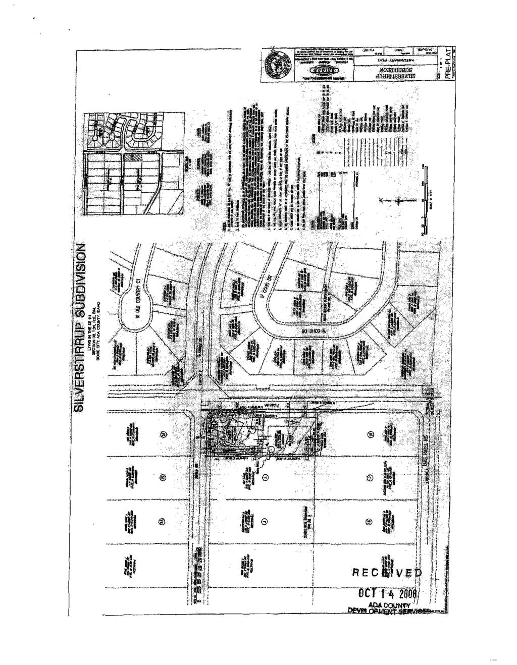
1 INTEROFFICE MEMORANDUM DATE: February 3, 2009 TO: Public Works Commission FROM: Mike Sheppard, P.E, Civil Engineer SUBJECT: Appeal of Boise City Public Works Denial of Request for an Alternative Sewer Route to Serve Development Silverstirrup Subdivision, 7405 W. Stirrup ISSUE Briggs Engineering, Inc. on behalf of the owner, Scott Goodman, is requesting to appeal Boise City Public Works decision to deny the subject subdivision an alternate sewer service route which deviates from the Master Sewer Plan and policy. (See attached letter) BACKGROUND This is a proposed two lot residential subdivision. An existing house is to remain on one of the lots. Please see attached Preliminary Plat. The proposed subdivision is located in Ada County but within Boise City s Sewer area of impact and sewer service area. The preliminary plat for the subdivision has been recommended for denial by the City of Boise for not complying with the Comprehensive Plan and has been recommended for denial by the staff of Ada County Development Services. The Subdivision Staff Report has been attached for your convenience. The proposed subdivision is requesting to drain to a different sewer service area rather than the drainage area it is located in. The Master Sewer Study (see attached map) incorporates many factors into the service area: the capacity of the existing conveyance system, topography and future development. In addition the drainage area they are proposing to drain into is currently being served by a temporary lift station. The capacity of this lift station is limited and capacity has been reserved for future development within the drainage area that the lift station serves. Adding two additional units to the system may not impact the capacity of the system; however, allowing the subject development to connect would set a precedent for others to connect which will have an impact on the capacity of the existing system. It would be difficult for Public Works to approve this application and deny any future developments with the same request. The applicant has proposed to construct 475 linear feet of 8" sewer main and two (2) sewer manholes to temporarily serve the two lot subdivision, future development may also want to construct temporary sewer main and manholes for which the City will also be responsible to own 1
2 and maintain. Ultimately, this deviation from the sewer master plan would result in the City maintaining 475 extra feet of sewer line. Also, this property is located in the Southwest Impact Area and therefore, in accordance with the Sewer Extension Policy any conditions set by Mayor and City Council would need to be adopted by Ada County prior to staff approval of the sewer design plans. RECOMMENDATION Staff recommends that the subject property be served in accordance with the City's Master Sewer Plan and not the alternative route proposed by the applicant. MOTION I move that staff recommendations are upheld that the applicant follow the master sewer plan to serve the subdivision and the proposed alternative sewer route by the applicant be denied. H:\msoffice\Word\Mike\Silverstirrup Sub PWC Agenda.doc 2
3 , r- a N '" UJ ld '" U UJ UJ a c- UJ f- f a -' ll.., f- Cf) -' j \5 m "".1" t!<l,., CD e,).... (/)... - z,.,. i v a i! i ) /.oj/'., '" 0 I z i.' I i1 i z 0: I! I 11 " (f) z 0 Ii (f), - > w I 0::.! U F,, ';f5 Om
4
5 Planning & Development Services Boise city Hall, 2nd Floor Phone: 208/ N. CopHol Boulevord Fox: 208{ p. O TDD{TTY: 8OO{ Boise/ Idaho MOSCO Website: Subdivision Staff Report Subdivision Name Silverstirrup Subdivision File Number SUB Approval Preliminary Plat Lead Agency Ada County Annexation Date NA Compo Plan Does Nol Comply Public Hearing Date December 9, 2008 Heard by Boise City Council Analyst David Abo, AlCP Description: This is a proposed residential subdivision with two lots. The site is currently zoned RI (Estate Density Residential) and the applicant is requesting a rezone to R4 (Medium Low Density Residential). The site is.90 acres in size with a proposed density of 2.22 lots per acre. Location: The site is located on the west side of South Cole Road, approximately 4,600 feet south of West Amity Road. Traffic Existing Condition of Area Roadways: Roadway Frontage Functional Classification Cole Road 308' Principal Arterial Traffic Count 9,370 south of Amity Road on 4/11/2007 Level of Service* Better than "'C" Speed Limit 35 MPH I Stirrup Avenue 130' Local N/A N/A 20 MPH VTD). *Acceptable level of sen-lce for a two-lane pnnclpal artenal roadway IS "E" (15, Capital Improvements PlanfFive Year Work Plan There are no roadways, bridges or intersections in the general vicinity of the project currently scheduled in the Five Year Work Plan. Cole Road between Lake Hazel and Desert Road is listed in the Capital Improvements Plan (ClP) to be widened to 5-lanes between the 2014 and 2018.
6 Contents: Basis for Recommendation Vicinity Map Preliminary Plat Aerial Map Technical Review and Agency Comments SUB / Silverstirrup Subdivision / Preliminary Plat Boise City Council/December 9, 2008 Page 2 of 16
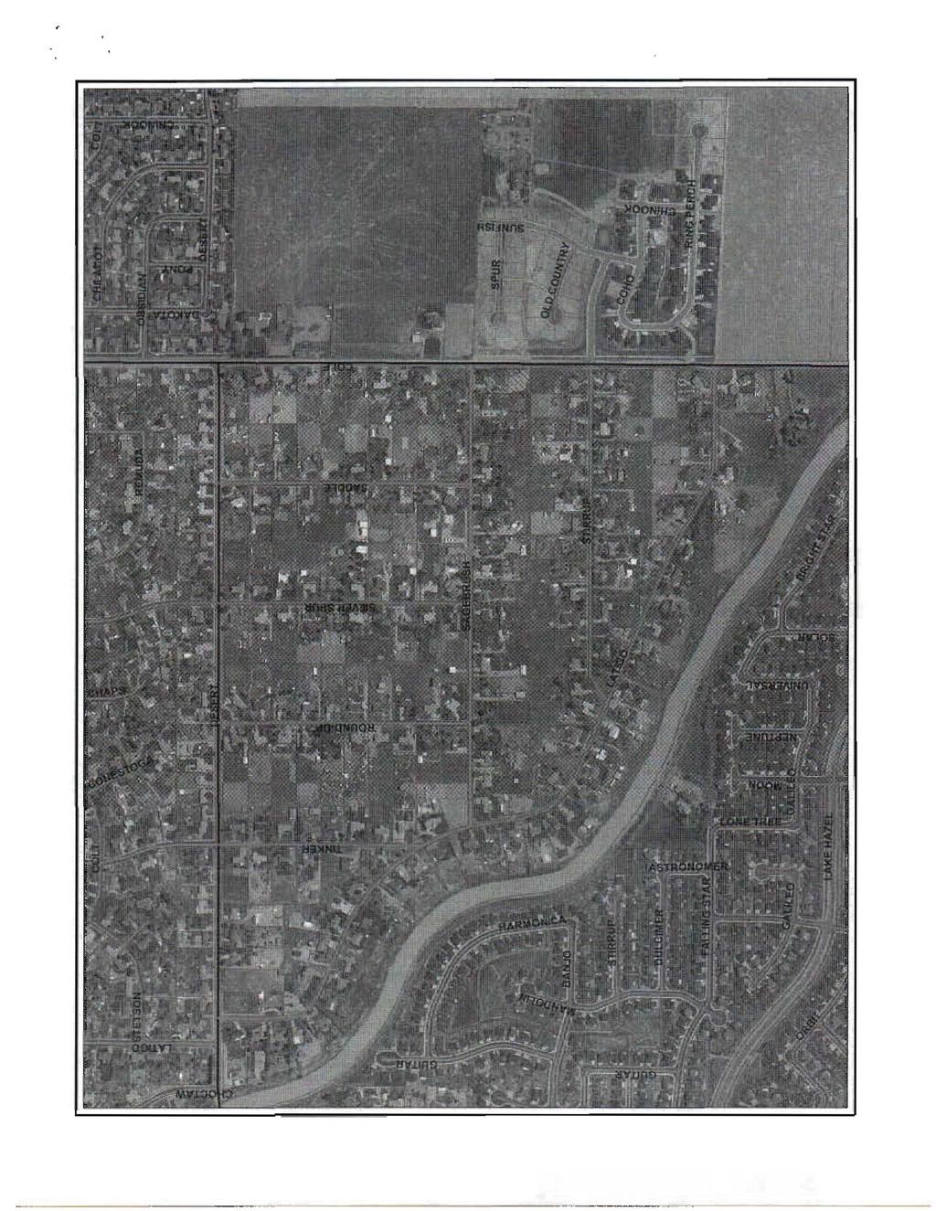
7 SUB / Silverstirrup Subdivisiou / Preliminary Plat Boise City Council/December 9, 2008 Page 3 of 16 Basis for Recommendation The plat design, layout and rezone to R4 are m not conformance with the Boise City Comprehensive Plan. Staff Perspective - From Analysis of Comprehensive Plan Compliance The applicant is proposing to rezone.9 acres from RI to R4, variances to reduce street frontage and screening easement requirements and a two lot preliminary plat. The proposed subdivision is located in the Sunset West #2 subdivision, which was platted in 1973 and consists almost entirely of approximately I acre lots in the impact area. This area will likely redevelop in the future with higher densities, however no plan is in place that would guide the direction of any redevelopment. The applicant's proposal to split off the back of his lot could lead to a fragmented and disjointed redevelopment pattern in the area. Since the applicant's original submittal, a revised site plan indicating direct lot access onto South Cole Road for the proposed southern lot was submitted to ACHD for a waiver of the access management policy. Staff does not support this revised plan as it is in direct conflict with Comprehensive Plan policy 7.3.4, "Limit access to all arterial streets" and policy 7.3.6,"Improve access control on existing streets through the review of new developments". ACHD has denied the applicant's request and will not allow direct lot access onto South Cole Road so the applicant is moving forward with their original request for a flag lot configuration with access onto Stirrup Avenue. The applicant is creating two lots that are 19,820 square feet and 20,022 square feet. The applicant would be required to connect to sewer due to the size of the lots, however the closest available sewer connection point is approximately one mile away and would require the applicant to spend approximately $1 million to extend sewer. The lack of sewer availability indicates that the City cannot provide urban services to the site at this time. Because there is no plan in place for redevelopment of the area as well as the City's inability to provide sewer to the site, staff is recommending denial of the rezone, variance and subdivision plat and finds no conditions that would make the proposed Silverstirrup Subdivision compliant with the Boise City Comprehensive Plan.

8
9 iill!lii n;r r;;.' I,.. I l II!I II 'G j..i,i. i"1 "I 'I ir!il!;') ". H H @ iilj '!if, ml I" if ru j 'dt RECivE ;!, -_._...-_._------
10
11 SUB I Silverstirrup Subdivision I Preliminary Plat Boise City Council I December 9, 2008 Page 4 of 16 Technical Review and Agency Comments Boise City Planning and Development Services: Subdivision Section - David Abo, AICP The subdivision must comply with Boise City Comprehensive Plan and conditions of the Boise City Public Works Department. Comprehensive Planning Section - Jennifer Tomlinson, December 2, 2008 Boise City is providing comment on the above-listed application relative to its consistency with the goals and policies of the Boise City Comprehensive Plan and pursuant to the requirements of the Area ofimpact Agreement. The subject property is located on the southwest comer of West Stirrup Avenue and South Cole Road. This is an application for a subdivision, zone change from Rl to R4, variances to street frontage and screening easement requirements and a two lot preliminary plat on approximately.9 acres. The property is located in the Southwest planning area and has been designated on the Land Use Map as Estate Density Residential (3 DU/acre). The following Comprehensive Plan policies are applicable to this application: Chapter 6-Transportation Objective Encourage completion of the existing street system and creation of new links, within reasonable constraints, as the transportation system develops. Policy All new development shall be reviewed for appropriate opportunities to connect to local roads and collectors in adjacent developments. Objective 6,1.4-Promote land use policies that limit access as necessary to maintain safe and efficient operation of the existing street system while allowing reasonable access to individual development parcels. Policy Improve access control on existing streets through the review of new developments. Objective Maintain safe and comfortable neighborhoods by minimizing speeding and cutthrough traffic. Policy New developments shall be required to stub access to adjacent undeveloped parcels where appropriate.
12 SUB ! Silverstirrup Subdivision! Preliminary Plat Boise City Council! December Page 5 of 16 Objective 6.4- Promote land use policies that limit access as necessary to maintain safe and efficient operation of the existing street system while allowing reasonable access to individual parcels. Policy Support the access restriction policies of the Ada County Highway District. Policy Limit access to arterial streets. Policy Improve access control on existing streets through the review of new developments. Chapter 7- Community Quality Objective 7.6- Promote energy efficiency in new and existing housing. Policy Promote energy conservation features in the design of all new housing developments and encourage installation of conservation devices in existing equipment. Residential Development Objective 7.2- Ensure through urban design the development of new residential structures that are functional and aesthetically pleasing. Policy 7.4- Require that residential street scenes provide variety and modulation in design and placement of homes. Objective 7.4- Reinforce the development of functional and visually appealing neighborhoods. Policy Establish a continuous network of sidewalks, bicycle and/or pedestrian paths to establish internal and external linkage within the community. Chapter 8- Land Use Goal 8.0- Achieve a city that minimizes suburban sprawl that provides for a diverse mixture of lifestyles and atmospheres and a sense of place that varies throughout the different areas of the city, and that efficiently provides basic services and facilities in close proximity to where people live. Objective 8.1- The land use map and attendant policies shall be the official guide for development of the planning area and shall be implemented through zoning and development review. Policy The Land use/zoning Consistency Matrix shall identify the zoning districts that are pem'issible within each land-use designation. Conformance with the Land Use/Zoning Consistency Matrix shall be a necessary finding of approval for all zone changes and conditional uses, unless one or more of the fom,s of flexibility identified in the policies under Objective 2 are implemented.
13 SUB I Silverstirrup Subdivision I Preliminary Plat Boise City Council I December 9, 2008 Page 6 of 16 Table Definitions of Land Use Map Designations Paoe 2 of 3 Land Use Applies To Allowed Uses and/or Limitations FAR Estate Residential 3 Slightly higher density in the developed portion of the Southwest Area 9,000 square-foot lots, overall target density af 3 units per gross acre. Clustering of units through Planned Unit Developments (PUDs may be allowed on smaller lots None Land Use Estate Residential OU/acre 3 A U R la R 16 R lc R 1M R 2 R 3 N 0 X X X X X L 0 R 0 C 1 C 2 C 3 C 4 C 5 PC H S M 1 M 2 M 4 T 1 T 2 Objective 8.3-Achieve a compact city comprised of a central Downtown with surrounding neighborhoods that have a center focus combining residential, commercial, employment, civic, cultural and recreational uses. Policy Development projects shall cumulatively form communities that have a center focus combining residential, commercial, employment, civic, cultural and recreational uses. Objective 8.6- Residential land uses shall be designated to provide a variety of housing densities, product types and affordable costs, and shall be located and distributed in a manner that is compatible with adjacent uses and promotes transit and pedestrian activity. Policy Residential development projects greater than 10 acres shall be encouraged to provide a combination ofproduct types and densities rather than a single product type. Chapter 9-Economic Development Policy Ensure that sufficient housing opportunities are provided in the Boise Planning area to provide a labor force that is in balance with available jobs. Chapter IO-Growth Management Goal Preserve, protect and enhance the overall quality of life in Boise and its Arca of Impact by ensuring that growth occurs in an orderly manner and that public services are available along with development. Objective 10.I-Ensure that growth is planned and directed in a way that minimizes sprawl and creates a functional and pleasing community. Figure 10-1 Level of Service Standards for Community Services and Facilities Service Service Standards Service Area
14 SUB / Silverstirrup Subdivision / Preliminary Plat Boise City Council I December 9, 2008 Page 7 of 16 TYPE 1-CONCURRENT WlTH THE ISSUANCE OF ANY DEVELOPMENT PERMIT Fire" 4 minute response, unless excepted by Fire Department 1.5 mile Water 35 psi residential!1,500 gpm fire flow Community 40 psi non-residential!1,500 gpm fire flow Community Sewer Available to site Community Treatment: Federal Standards + capacity Collection: capacity Schools System capacity Community Streets Authorization by ACHD Community Police/Sheriff Available Solid Waste Weekly pick-up Community Electricity Available Community Telephone Available Community Storm Drainage Approved on site or public system Community Fire Station "set-a-side" shall be required within the City Area of Impact. See the exception for the Southwest Planning Area identified under Objective 2, Policy 2 in the Sewer Facilities section of the "Public Facilities, Utilities and Services" Chapter of this Plan. ANALYSIS The applicant is proposing to rezone.9 acres from RI to R4, variances to reduce street frontage and screening easement requirements and a two lot preliminary plat. The proposed subdivision is located in the Sunset West #2 subdivision, which was platted in 1973 and consists almost entirely of approximately 1 acre lots in the impact area. This area will likely redevelop in the future,,-ith higher densities, however no plan is in place that would guide the direction of any redevelopment. The applicant's proposal to split off the back of his Jot could lead to a fragmented and disjointed redevelopment pattern in the area. Since the applicant's original submittal, a revised site plan indicating direct lot access onto South Cole Road for the proposed southern lot was submitted to ACHD for a waiver of the access management policy. Staff does not support this revised plan as it is in direct conflict with Comprehensive Plan policy 7.3.4, "Limit access to all arterial streets" and policy 7.3.6,"lmprove access control on existing streets through the review of new developments". ACHD has denied the applicant's request and will not allow direct lot access onto South Cole Road so the applicant is moving forward with their original request for a flag lot configuration with access onto Stirrup Avenue. The applicant is creating two lots that are 19,820 square feet and 20,022 square feet. The applicant would be required to connect to sewer due to the size of the lots, however the closest available sewer connection point is approximately one mile away and would require the applicant to spend approximately $1 million to extend sewer. The lack of sewer availability indicates that the City cannot provide urban services to the site at this time. Because there is no plan in place for redevelopment of the area as well as the City's inability to provide sewer to the site, staff is recommending denial of the rezone, variance and subdivision plat and finds no conditions that would make the proposed Silverstirrup Subdivision compliant with the Boise City Comprehensive Plan.
15 SUB / Silverslirrup Subdivision / Preliminary Plat Boise City Council/December 9, 2008 Page 8 of 16 Boise City Public Works: Engineering - Rob Bousfield No comments. Pressure Irrigation - Kent Johnson Comply with Boise City Code Section J and Idaho Code, Section Sewer - Mike Sheppard, October 31, 2008 a. The developer and/or owner shall delineate all necessary Boise City sanitary sewer easements on the final plat prior to signing of the final plat by the Boise City Engineer (Boise City Code F, Design Standards; Easements). b. WetIine sewers are required (Boise City Code D, Improvements; Sanitary Sewers). i) Developer and/or o,vner shall contact the Public Works Department regarding the financing and details ofextending the sewers to the subject property. Developer and/or owner shall enter into a sewer reimbursement agreement with the City of Boise. ii) Plans shall be submitted to and approved by the Boise City Public Works Department prior to commencing with construction. Developer and/or owner may either construct improvements prior to final platting or execute a performance agreement and provide surety in the amount of 110% of the estimated costs. The developer and/or owner shall coordinate with the Public Works Department for construction inspection prior to and during construction. Unless otherwise approved by the Public Works Department, all sewer construction shall be completed and accepted within 90 days of plat recordation or within 30 days of issuance of the first building permit within the subdivision, whichever comes first. NOTE: All bonding shall conform to Boise City Code 1-19, Surety Bonds. iii) Developer and/or owner shall pay the current sewer inspection fees for the proposed subdivision prior to signing of the final plat by the Boise City Engineer. iv) Developer and/or owner shall be responsible for repairs of any failures that occur within one (I) year of the project acceptance by the appropriate sewer entity (Boise City Code, Improvements; Sanitary Sewers). v) All lots within this subdivision shall be subject to and restricted by the following recorded subdivision covenants: (a) A monthly sewer charge must be paid after connecting to the Boise City public sewer system, according to the ordinances and laws ofboise City. (b) Owner shall submit to inspection by either the Public Works Department or the Building Department whenever a subdivided lot is to be connected to the City's sewage system and a building is constructed or installed on or within the owner's property. (cj The developer and/or owner of this subdivision or lot or lots therein shall and hereby does vest in Boise City the right and power to bring all actions against the owner of the premises hereby conveyed or any part thereof for the
16 SUB / Silverslirrup Subdivision / Preliminary Plat Boise City Council j December 9, 2008 Page 9 of 16 collection of any charges herein required and to enforce the conditions herein stated. This covenant shall run with the land. (d) The recording of this plat by developer and/or owner shall be deemed and construed as a request for annexation of its property to the corporate limits of Boise City. Such request and consent shall be binding on all subsequent purchasers or owners of developer's property. (e) Covenants to be approved by the Boise City Attorney. b. Unless previously paid, developer and/or owner shall pay a connection fee and physically connect to sewer the existing building on Lot(s) I, Block I prior to signing of the final plat by the Boise City Engineer or post bond/agreement for 110% of the cost to connect. NOTE: All bonding shall conform to Boise City Code, B.3, Improvements; Filing of Plans and Surety, which specifies that the improvements to be made shall be done in a time period not to exceed one year from the date of approval of the final plat. Special Conditions: Prior to granting final sewer construction plan approval, recommendation of approval by Boise City Council and confirmation of the county adopting these recommendations are required per Boise City's sewer extension policy, Street Lights - Henry Alarcon, October 31, 2008 No street lights required. Boise City street light easement(s) required. Boise City Fire Department - Mark Senteno, November 3, 2008 The Boise Fire Department has reviewed and can approve the application subject to compliance with all following code requirements and conditions of approval. Any deviation from this plan is subject to Fire Department approval. Please note that unless stated otherwise this memo represents requirements of the International Fire Code as adopted and amended by Ordinance Code ReqUirement: Fire Department vehicular access shall be provided to within ISO' of all portions of nonsprinklered buildings. Any dead-end road in excess of ISO' needs a Fire Department approved turnaround. Single access roads are prohibited from exceeding 750 feet without special approval. These distances can be increased somewhat for sprinklered buildings but exact distances are on a case-by-case basis. All Fire Department access roads, fire lanes, bridges, and gates are to be a minimum of 20' wide with 13' 6" overhead clearance, shall be capable of supporting 70,000 lb. GVW (24,000 Ibs per axle), and shall be paved. Fire Department access roads and fire lanes shall have a minimum outside turning radius of 48' with an inside radius of 28'. Aerial fire apparatus roads shall have a minimum unobstructed width of 26 feet in the immediate vicinity of any building or portion of building more than 30 feet in height, and at least one of the required access routes meeting this condition shall be located within a minimum of 15 feet and a maximum of 30 feet from the buildlllg, and shall be positioned parallel to one entire
17 SUB / Silverstirrup Subdivision / Preliminary Plat Boise City Council/December 9, 2008 Page 100f16 side of the building. No grade may exceed 10% (please note that fire apparatus are designed for a maximum 6% gradel. Width and turning radius measurements specified by this paragraph can include those surfaces vehicles generally drive upon. Specifically, gutter and rolled curb are generally considered useable, while vertical curb or sidewalks are not. Comments: Project is 4 Y, miles from the closet current fire station. Code Requirement: For streets having a width less than 36 feet back of curb to back of curb parking shall be restricted on (1 lone side; for streets having a width less than 29 feet back ofcurb to back ofcurb parking shall be restricted on both sides; and for standard ACHD cul-de-sacs parking shall be restricted on both sides. A note on the face of the final plat is required noting the parking restriction prior to signing of the final plat by the Boise City Engineer. In addition, No Parking signs shall be installed in accordance with the requirements of the IFc. Code Requirement: Fire hydrant number and distribution is dependant on the International Fire Code Appendix C, Table CI05.1. Comments: One fire hydrant has been noted. In the absence of information on existing hydrants it appears that no new hydrants may/will be needed. However, we reserve the right to modify requirements as more infornlation comes to light. Variables affecting hydrant numbers and location include, but are not limited to, area, construction type, existing hydrants, accuracy of information provided in the application, strategic location for fire fighting forces, and required fire flow. New hydrants must be "non-private" installations. General Requirement: Fire Department required fire hydrants, access, and street identification shall be installed prior to construction or storage of combustible materials on site. Provisions may be made for temporary access and identification measures. Specific building construction requirements of the International Building Code, International Fire Code, and Boise City Code will apply. However, these provisions are best addressed by a licensed Architect at building permit application. Please feel free to have the applicant contact Mark Senteno,
18 SUB / Silverstirrup Subdivision / Preliminary Plat Boise City Council/December 9,2008 Pagellofl6 Ada County Highway District Project/File: Lead Agency: Ada County Site address: Silverstirrup Subdivision/ OO-S-V-ZC-DA This is a rezone. variance, and preliminlll}' plat application for a 2-lot residential subdivision on W. Stirrup Avenue Commission Hearing: November 19, 2008 Commission Approval: November 19,2008 Applicant: Scott Goodman 5710 Vanessa Court Woodland Hills, CA Representative: Briggs Engineering Sabrina Whitehead 1800 W. Overland Rd. Boise, ID Staff Contact: Kristy Scovill Phone: kscovill/a:al..;hd.ada.id.us Tech Review: Application Information: Acreage:.9 Current Zoning: R I Proposed Zoning: R4 Buildable Lots: 2 A. Findings of Fact Existing Conditions November 6, 2008 (via ) I. Site Information: This site consists ofone residential home. 2.
19 SUB I Sih'erstirrup Subdivision I Preliminary Plat Boise City Council 1 December Page 120f16 4 South Medium Density Residential (Skylight Subdivision) R-6 East Medium Low Density Residential (Southfork Subdivision) R-4 West Estate Residential (Sunset West Subdivision) R-I 3. Existing Roadway Improvements and Right-of-Way Adjacent To and Near the Site Cole Road is improved with 2 traffic lanes, 29-feet or pavement, and vertical curb & gutter... ithin 8! -feet of right-or-way (33 feet from centerhne) abutting the site. There is dct:jched sidewalk to the east of the sill' Stirrup Avenue is improved with 2 traffic lanes, 33-feet of p3yement. and rolled curb and gutter within 60-feet of right-of-way no-feet from centerlme) <lbuning the site. Existing Access: There is one defined access points to this property located off of Stirrup Avenue. 5. Site History: ACHD has not previously reviewed this site for a development application. 6. Adjacent Development: Arbor Hills Planned Community located south of the site along a future extension of Cole Road. At build out the Planned Community will consist of 6,700 residential units,150,0000 square feet of retail, 400,000 square feet of office, 6 schools, 8 churches, I library, 2 hotels, 188 acres for parks and 5 community centers on 2, acres. The Arbor Hills Planned Community application was heard and approved by the ACHD commission on August 27, Development Impacts 7. Trip Generation: This development is estimated to generate 10 additional (10 existing) vehicle trips per day based on the Institute of Transportation Engineers Trip Generation Manual. 8. Impact Fees: There will be an impact fee that is assessed and due prior to issuance ofany building pennits. The assessed impact fee will be based on the impact fee ordinance that is in effect at that time. 9. Existing Condition of Area Roadways: Roadway Frontage Functional Classification Cole Road 308' Principal Arterial Traffic Count 9,370 south of Amity Road on 4/11/2007 Level of Service* Better than "e" Speed Limit 35 MPH Stirmp Avenue 130' Local N/A N/A 20 MPH VTD) *Acceptable level of service for a two-lane pnnclpal artenal roadway IS HE" (15, Capital Improvements Plan/Five Year Work Plan Illere are no roadways, bridges or intnsections in the general VIcinity ofthe project cuitently scheduled to the Five Year Work Plan.
20 StTB / Silverstirrup Subdivisiou / Preliminary Plat Boise City Council/December 9, 2008 Page 13 of16 Cole Road bel,,",'een Lake Hazel and Desert Road is hsred in the Capifallmprow:mCnl5 Pbl! (CJP)lO be widened to 5-1ancs between the 2014 and B. Findings for Consideration I. Cole Road Right-of-Way Policy: District policy requires 96-feet of right-of-way on arterial roadways (Figure 72-FI B). This right-of-way allows for the construction of as-lane roadway with curb, gutter, 5-foot concrete detached sidewalks and bike lanes. Applicant Proposal: The applicant has not proposed any improvements to Cole Road. Staff CommentlRecommendation: The applicant will be required to dedicate 48-feet of right-of-way abutting the site, OR dedicate 38-feet of right-of-way from centerline and provide a 10-foot sidewalk easement along Cole Road abutting the site. In either case, the applicant will be required to construct a 5-foot detached concrete sidewalk a minimum of 41-feet from the centerline of Cole Road abutting the site. 2. Stirrup Avenue Right-of-Way Policy: District policy and Figure 72-FIA requires 50-feet of right-of-way on local streets. This right-otway allows for the construction of a 2-lane roadway with curb, gutter and 5-foot wide concrete sidewalks. Applicant Proposal: Avenue. The applicant has not proposed any improvements to Stirrup Staff Comment/Recommendation: Typically, the applicant would be required to construct a 5-foot wide concrete sidewalk abutting the site. However, staff recommends a modification of policy to not require the construction of sidewalk abutting Stirrup Avenue due to the sites limited frontage and the lack of existing sidewalks abutting and near the site. 3. Driveways Access Management Policy: District policy states that direct access to arterials and collectors is nonnally restricted. The developer shall try to use combined access points. Ifthe developer can show that the use ofa combined access point to a collector or arterial street is impractical, the District may consider direct access points. Access points for proposed developments at intersections should be located as far from the intersection as practical, and in no case closer than as illustrated on Figure 72-F4, unless a waiver for the access point has been approved by the District Commission. Driveway PaVing Policy: Graveled driveways abutting public streets create maintenance problems due to gravel being tracked onto the roadway. In accordance with District policy, , the applicant should be required to pave the driveway its full width and at least 3D-feet into the site beyond the edge of pavement of the roadway and install pavement tapers with IS-foot radii abutting the existing roadway edge. Residential Driveway Width Policy: District Policy restricts residential driveways to a maximum width of20-feet.
21 '.. SUB / Silverstirrup Subdivision / Preliminary Plat Boise City Council/December 9, 2008 Page 14 of 16 Applicant's Proposal: The applicant is proposing to utilize the existing driveway access near the west property line on Stirrup Avenue, and provide a cross access agreement with the new lot to the south. Since receiving the original transmittal from Ada County, the applicant has requested to take direct lot access to Cole Road. Staff Comment/Recommendation: The applicant's proposal meets District policy and should be approved as proposed. The applicant will be restricted to a maximum driveway width of 20-feet and required to pave the driveway its full width and at least 30-feet into the site beyond the edge of pavement of the roadway. The applicant will be required to provide written documentation to the District of the cross access agreement. Staff is not supportive of the applicant's request to take access off of Cole Road. Cole Road is classified as a principal arterial roadway; District Access Management Policy states that direct lot access to arterial roadways is normally restricted. This site has access to a local street (Stirrup Avenue) and the applicant has demonstrated that access can be taken from the local street. Additionally, this section of Cole Road is listed in the District's Capital Improvement Plan to be widened to 5-lanes in the future with connections south providing access to Arbor Hills planned community. Commission Discussion: Commission approved the staff report, as written, requiring the applicant to take access off Stirrup Avenue through a cross access agreement, as originally proposed, located near the west property line. 4. Tree Planters Tree Planter Policy: The District's Tree Planter Width Policy prohibits all trees in planters less than 8-feet in width without the installation of root barriers. Class II trees may be allowed in planters with a minimum width of 8-feet, and Class I and Class III trees may be allowed in planters with a minimum width of 10-feet. 5. Other Access Cole Road is classified as a principal arterial roadway. Direct lot access to this roadway is prohibited, and shall be noted on the final plat. C. Special Note to Ada County Driveways on arterial roadways are prohibited Driveways should be located on local streets whenever possible to limit driveways on arterial roadways. D. Site Specific Conditions of Approval 1. Dedicate either 48-feet of right-of-way from the centerline of Cole Road abutting the parcel, or 38-feet of right-of-way from the centerline of Cole Road abutting the parcel with a lo-foot public sidewalk and utility easement. The right-of-way purchase and sale agreement and deed must be completed and signed by the applicant prior to scheduling the final plat for signature by the ACHD Commission or prior to issuance of a building permit (or other required permits), whichever occurs first. Allow up to 30 business days to process the right-of-way dedication after receipt of all requested material. The District
22 SUB I Silverstirrup Subdivision I Preliminary Plat Boise City Council I December 9, 2008 Page 150f16 will purchase the right-of-way which is in addition to existing right-of-way from available Corridor Preservation Funds. 2. Construct a detached 5-foot wide concrete sidewalk located a minimum of 41-feet from the centerline of Cole Road abutting the site. 3. Utilize the existing driveway on Stirrup Avenue located near the west property line. The driveway is restricted to a maximum width of 20-feet. Pave the driveway its full width and at least 3D-feet into the site beyond the edge of pavement of the roadway and install pavement tapers with IS-foot radii abutting the existing roadway edge. 4. Provide written documentation to the District of the cross access agreement. 5. Direct lot access to Cole Road is prohibited, and shall be noted on the final plat. 6. Comply with au Standard Conditions of Approval. D. Standard Conditions of Approval I. Any existing irrigation facilities shau be relocated outside ofthe right-of-way. 2. Private sewer or water systems are prohibited from being located within any ACHD roadway or right-of-way. 3. All utility relocation costs associated with improving street frontages abutting the site shall be borne by the developer. 4. Replace any existing damaged curb, gutter and sidewalk and any that may be damaged during the construction of the proposed development. Contact Construction Services at (with file number) for details. 5. Comply with the District's Tree Planter Width Interim Policy. 6. Utility street cuts in pavement less than five years old are not allowed unless approved in writing by the District. Contact the District's Utility Coordinator at (with file numbers) for details. 7. All design and construction shall be in accordance with the Ada County Highway District Policy Manual, ISPWC Standards and approved supplements, Construction Services procedures and all applicable ACHD Ordinances unless specifically waived herein. An engineer registered in the State of Idaho shall prepare and certify all improvement plans. 8. The applicant shall submit revised plans for staff approval, prior to issuance ofbuilding permit (or other required permits), which incorporates any required design changes.
23 SUB / Silverstirrup Subdivision / Preliminary Plat Boise City Council / December 9,2008 Page 160fl6 9, Construction, use and property development shall be in conformance with all applicable requirements of the Ada County Highway District prior to District approval for occupancy. 10. Payment ofapplicable road impact fees are required prior to building construction in accordance with Ordinance #200, also known as Ada County Highway District Road Impact Fee Ordinance. 11. It is the responsibility ofthe applicant to verify all existing utilities within the right-ot way. The applicant at no cost to ACHD shall repair existing utilities damaged by the applicant. The applicant shall be required to call DlGLINE ( ) at least two full business days prior to breaking ground within ACHD right-of-way. The applicant shall contact ACHD Traffic Operations in the event any ACHD conduits (spare or filled) are compromised during any phase of construction. 12. No change in the tenns and conditions of this approval shall be valid unless they are in writing and signed by the applicant or the applicant's authorized representative and an authorized representative of the Ada County Highway District. The burden shall be upon the applicant to obtain written confirmation of any change from the Ada County Highway District. 13. Any change by the applicant in the planned use of the property which is the subject of this application, shall require the applicant to comply with all rules, regulations, ordinances, plans, or other regulatory and legal restrictions in force at the time the applicant or its successors in interest advises the Highway District of its intent to change the planned use of the subject property unless a waiver/variance of said requirements or other legal relief is granted pursuant to the law in effect at the time the change in use is sought. Eo Conclusions of Law 1. The proposed site plan is approved, ifall of the Site Specific and Standard Conditions of Approval are satisfied. 2. ACHD requirements are intended to assure that the proposed use/development will not place an undue burden on the existing vehicular transportation system within the vicinity impacted by the proposed development.
Subdivision Staff Report
 Subdivision Staff Report Subdivision Name Coldstream File Number SUB06-00040 Subdivision Approval Preliminary Plat Lead Agency Boise City Annexation Date December 9, 1974 Comp. Plan Complies Public Hearing
Let me know if I need to bring you any other documentation for this withdrawl. Thanks!
 >>> david benoit 11/27/2007 10:00 AM >>> Dave, I am set to be heard on the Cranston Corner Subdivision on December 4th in front of City council. I have sold this property and am requesting
Subdivision Staff Report
 Subdivision Staff Report Subdivision Name Sunnyridge Subdivision File Number SUB07-00007 Approval Preliminary Plat Lead Agency Ada County Annexation Date NA Comp. Plan Complies (With Conditions of Approval)
Subdivision Staff Report
 Subdivision Staff Report Subdivision Name Toli Park Subdivision File Number SUB07-00035 Approval Preliminary Plat Lead Agency Boise City Annexation Date December 30, 1987 Comp. Plan Complies Public Hearing
Hal Simmons Planning Director Boise City Planning and Development Services. CAR / 1689 South Entertainment Avenue
 MEMORANDUM MEMO TO: FROM: Mayor and Boise City Council Hal Simmons Planning Director Boise City Planning and Development Services DATE: November 15, 2008 RE: CAR08-00019 / 1689 South Entertainment Avenue
Subdivision Staff Report
 Subdivision Staff Report Subdivision Name Honeymoon Cove Subdivision File Number SUB08-00005 Approval Preliminary/ Final Plat Lead Agency Boise City Annexation Date December 30, 2004 Comp. Plan Complies
RE: CAR / 4280 N.
 MEMORANDUM TO: FROM: Mayor and Boise City Council Hal Simmons - Planning Director Boise City Planning and Development Services DATE: April 29, 2009 RE: CAR09-00006 / 4280 N. Eagle Road The following application
Committed to Service
 Committed to Service Paul Woods, President Rebecca W. Arnold, Vice President Sara M. Baker, Commissioner Jim D. Hansen, Commissioner Kent Goldthorpe, Commissioner August 25, 2017 Development Services TO:
Date: March 16, Jake Centers ERD, LLC P.O. Box 1610 Eagle, ID Elevation Ridge Subdivision (SUB & PUD ) Street Address
 Street Address") Rebecca W. Arnold, President Sara M. Baker, Vice President John S. Franden, Commissioner Carol A. McKee, Commissioner David L. Case, Commissioner Date: March 16, 2012 To: Jake Centers ERD, LLC P.O. Box
Rebecca W. Arnold, President Sara M. Baker, Vice President John S. Franden, Commissioner Carol A. McKee, Commissioner David L. Case, Commissioner Date: March 16, 2012 To: Jake Centers ERD, LLC P.O. Box
May 21, ACHD Board of Commissioners Stacey Yarrington, Planner II DRH /DRH
 Development Services Department May 21, 2013 TO: FROM: SUBJECT: ACHD Board of Commissioners Stacey Yarrington, Planner II DRH13-00106/DRH13-00108 Executive Summary: This is a design review application
Subdivision Staff Report
 Subdivision Staff Report Name: Brownstone Subdivision Date: May 12, 2004 File: SUB04-00041 Meeting: May 18, 2004 Approval: Preliminary To: City Council Lead Agency: Ada County (04-10-S) From: Richard Beck
Location: The subject property is located at the northeast corner of S. Holden Lane and E. Boise Avenue.
 Subdivision Staff Report Subdivision Name Tianna Park File Number SUB11-00008 Approval Preliminary Plat Lead Agency Boise City Annexation Date December 19, 1977 Comp. Plan Complies Public Meeting Date
Amended Subdivision Staff Report
 Amended Subdivision Staff Report Subdivision Name Silverpine Subdivision File Number SUB06-00052 No.2 Approval Preliminary Plat Lead Agency Ada County Annexation Date NA Comp. Plan Complies (With Conditions
BOI / DRH Albertsons grocery market and fueling center & pad sites
 Paul Woods, President Rebecca W. Arnold, Vice President Sara M. Baker, Commissioner Jim D. Hansen, Commissioner Kent Goldthorpe, Commissioner March 28, 2017 To: Mark Palmer Albertsons Companies 250 E.
Executive Summary: This is a preliminary plat to construct 8 residential lots and 2 commons lots with a private road on 3.87-acres in Meridian, Idaho.
 Development Services Department DATE: July 7, 2015 TO: FROM: SUBJECT: ACHD Board of Commissioners Stacey Yarrington, Planner III Kentucky Villas/ MPP15-0012/ PP15-009 Executive Summary: This is a preliminary
Right-of-Way & Development Services Planning Review Division Committed to Service This application is approved at the staff level on February 1, 2006.
 Right-of-Way & Development Services Planning Review Division Committed to Service This application is approved at the staff level on February 1, 2006. Tech Review for this item was held with the applicant
If you have any questions, please feel free to contact me at (208)
") Sara M. Baker, President John S. Franden, Vice President Rebecca W. Arnold, Commissioner Mitchell A. Jaurena, Commissioner Jim Hansen, Commissioner Date: March 21, 2013 To: Subject: Hornet Construction
Sara M. Baker, President John S. Franden, Vice President Rebecca W. Arnold, Commissioner Mitchell A. Jaurena, Commissioner Jim Hansen, Commissioner Date: March 21, 2013 To: Subject: Hornet Construction
Subdivision Staff Report
 Subdivision Staff Report Subdivision Name Greenfield Park File Number SUB06-00110 Subdivision Approval Preliminary/Final Plat Lead Agency Boise City Annexation Date December 9, 1974 Comp. Plan Complies
Time Extension Staff Report
 Time Extension Staff Report Subdivision Name Lunara Subdivision File Number SUB07-00019 Approval Time Extension for Lead Agency Boise City Certification Signature of Boise City Engineer Annexation Date
SUB /CAR /PUD
 Development Services Department Project/File: Lead Agency: Site address: Balntyre Court Subdivision/BPP16-0036/ SUB16-00066/CAR16-00035/PUD16-00040 This is a rezone, planned unit development, and subdivision
3. The preliminary plats were approved on March 27, 2014 and August 14, 2014.
 Jim D. Hansen, President Sara M. Baker, Vice President Rebecca W. Arnold, Commissioner Kent Goldthorpe, Commissioner Paul Woods, Commissioner February 12, 2015 Development Services Department To: From:
Committed to Service
 Committed to Service Kent Goldthorpe, President Paul Woods, Vice President Rebecca W. Arnold, Commissioner Sara M. Baker, Commissioner Jim D. Hansen, Commissioner July 18, 2016 Development Services TO:
Committed to Service
 Committed to Service Sara M. Baker, President Rebecca W. Arnold, Vice President Jim D. Hansen, Commissioner Kent Goldthorpe, Commissioner Paul Woods, Commissioner January 16, 2018 Development Services
#1 (CAR /SUB )
") Development Services Department Project/File: Lead Agency: Site address: Fork South #1 (CAR14-00009/SUB14-00024) The applicant is requesting annexation, rezone and preliminary plat approvals for a 52-lot
Development Services Department Project/File: Lead Agency: Site address: Fork South #1 (CAR14-00009/SUB14-00024) The applicant is requesting annexation, rezone and preliminary plat approvals for a 52-lot
Date: August 29, Dave Scaggs (sent via ) Summit Development Inc th Ave. Rd. #384 Nampa, ID 83686
 Summit Development Inc th Ave. Rd. #384 Nampa, ID 83686") Sara M. Baker, President John S. Franden, Vice President Rebecca W. Arnold, Commissioner Mitchell A. Jaurena, Commissioner Jim Hansen, Commissioner Date: August 29, 2013 To: Dave Scaggs (sent via email)
Sara M. Baker, President John S. Franden, Vice President Rebecca W. Arnold, Commissioner Mitchell A. Jaurena, Commissioner Jim Hansen, Commissioner Date: August 29, 2013 To: Dave Scaggs (sent via email)
Subdivision Staff Report
 Subdivision Staff Report Name: Madronawood Subdivision Date: January 26, 2005 File: SUB05-00005 Meeting: February 1, 2005 Approval: Preliminary To: City Council Lead Agency: Ada County (04-31-S) From:
Time Extension Staff Report
 Time Extension Staff Report Subdivision Name Therrin Subdivision File Number SUB06-00020 Approval Time Extension for Lead Agency Boise City Certification Signature of Boise City Engineer Annexation Date
Subdivision Staff Report
 Subdivision Staff Report Subdivision Name Birmingham Place File Number SUB06-00051 Subdivision Approval Preliminary/Final Plat Lead Agency Boise City Annexation Date December 3, 1962 Comp. Plan Complies
Subdivision Staff Report
 Subdivision Staff Report Subdivision Name Madera Creek File Number SUB06-00068 Subdivision Approval Final Plat Lead Agency Boise City Annexation Date December 9, 1974 Comp. Plan Complies Public Hearing
a. provide for the continuation of collector streets and thoroughfare streets between adjacent subdivisions;
 Section 7.07. Intent The requirements of this Section are intended to provide for the orderly growth of the Town of Holly Springs and its extra-territorial jurisdiction by establishing guidelines for:
Subdivision Staff Report
 Subdivision Staff Report Subdivision Name Athletic Subdivision File Number SUB08-00023 Approval Preliminary/ Final Plat Lead Agency Boise City Annexation Date July 30, 1984 Comp. Plan Complies Public Hearing
ARTICLE IV: DEVELOPMENT STANDARDS
 ARTICLE IV: DEVELOPMENT STANDARDS IV-53 409 PRIVATE STREETS A private street means any way that provides ingress to, or egress from, property by means of vehicles or other means, or that provides travel
SECTION 7000 LAND DEVELOPMENT REQUIREMENTS
 SECTION 7000 LAND DEVELOPMENT REQUIREMENTS 7000 LAND DEVELOPMENT REQUIREMENTS... 1 7001 LEGISLATIVE AUTHORITY... 1 7001.1 LAND DEVELOPMENT... 1 7001.1.1 Title 40, Idaho Code... 1 7001.1.2 Idaho Code 40-1415
WRITTEN DECISION OF THE HAYDEN CITY COUNCIL REGARDING MAPLE GROVE PRELIMINARY SUBDIVISION APPLICATION (SUB-0013) HAYDEN SIGNATURE, LLC
 HAYDEN SIGNATURE, LLC") WRITTEN DECISION OF THE HAYDEN CITY COUNCIL REGARDING MAPLE GROVE PRELIMINARY SUBDIVISION APPLICATION (SUB-0013) HAYDEN SIGNATURE, LLC Application of Hayden Signature, LLC, an Idaho limited liability company,
WRITTEN DECISION OF THE HAYDEN CITY COUNCIL REGARDING MAPLE GROVE PRELIMINARY SUBDIVISION APPLICATION (SUB-0013) HAYDEN SIGNATURE, LLC Application of Hayden Signature, LLC, an Idaho limited liability company,
Section Preliminary Plat Checklist and Application Forms
 Section 201 - Preliminary Plat Checklist and Application Forms PRELIMINARY SUBDIVISION PLAT REVIEW PROCESS CHART PRELIMINARY SUBDIVISION PLAT APPLICATION PRELIMINARY PLAT REVIEW CHECKLIST CITY OF NAMPA
SOS / Waiver of Subdivision Standards / John Cashin
 SOS15-00012 / Waiver of Subdivision Standards / John Cashin Summary John Cashin requests a Waiver of Subdivision Standards in the Boise Development Code that requires construction of new sidewalk for approval
ARTICLE 24 PRIVATE ROAD, SHARED PRIVATE DRIVEWAY AND ACCESS EASEMENT STANDARDS
 ARTICLE 24 PRIVATE ROAD, SHARED PRIVATE DRIVEWAY AND ACCESS EASEMENT STANDARDS SECTION 24.00 INTENT AND PURPOSE The standards of this Article provide for the design, construction and maintenance of private
DAUPHIN CREEK ESTATES SUBDIVISION
 # 12 SUB-000076-2017 DAUPHIN CREEK ESTATES SUBDIVISION Engineering Comments: FINAL PLAT COMMENTS (should be addressed prior to submitting the FINAL PLAT for review and/or signature by the City Engineer):
M-43 CORRIDOR OVERLAY ZONE
 ARTICLE 26.00 M-43 CORRIDOR OVERLAY ZONE Section 26.01 Findings A primary function of the M-43 state highway is to move traffic through the Township and to points beyond. As the primary east-west arterial
MAJOR ISSUES DISCUSSED To date, there has been no opposition to this request and no member of the public has testified. ***
 CAR07-00051 Page 2 SUMMARY Larry and Barbara Woolf request approval to rezone ± 1.33 acres from R-1C (Single Family Residential with a maximum of 8.0 DU/acre) to R-2D (Combined Residential with a maximum
Appendix A. Definitions
 Definitions 1. Terms Defined. Words contained in this are those having a special meaning relative to the purposes of this Ordinance. Words not listed in this section shall be defined by reference to: (1)
SOS ; State of Idaho, Consent to Partially Vacate Public Alley Rightof-Way at 611 North 6 th Street
 MEMORANDUM TO: FROM: Mayor and City Council David Abo, AICP Subdivision Review Analyst Boise City Planning and Development Services DATE: November 6, 2012 RE: SOS12-00013; State of Idaho, Consent to Partially
ZONING AMENDMENT, PLANNED UNIT DEVELOPMENT & SUBDIVISION STAFF REPORT Date: September 15, 2011
 ZONING AMENDMENT, PLANNED UNIT DEVELOPMENT & SUBDIVISION STAFF REPORT Date: September 15, 2011 NAME SUBDIVISION NAME LOCATION Stratford, L.L.C. Grelot Office Park Subdivision North side of Grelot Road,
ZONING AMENDMENT, PLANNED UNIT DEVELOPMENT & SUBDIVISION STAFF REPORT Date: August 8, 2013
 ZONING AMENDMENT, PLANNED UNIT DEVELOPMENT & SUBDIVISION STAFF REPORT Date: August 8, 2013 NAME SUBDIVISION NAME PV-Magnolia, LLC Twelve Trees Subdivision LOCATION 2860, 2862 and 2866 Pleasant Valley Road
TOWN OF LEWISTON PLANNING BOARD APPLICATION
 TOWN OF LEWISTON PLANNING BOARD APPLICATION DESCRIPTION OF PROPOSED REQUEST: Name of Property Owner: Phone #: Name of Applicant:Phone #: Address or Location of Proposal:_SBL# Size of Parcel or Structure:Existing
Plans shall be drawn at a readable scale, signed, and sealed by a Florida Registered Engineer. The application package shall include:
 CHAPTER 400. SECTION 403. PERMIT TYPES AND APPLICATIONS SITE DEVELOPMENT 403.3. Preliminary Site Plans (PSP) A. Intent and Purpose PSPs are used to identify existing site conditions and demonstrate general
APPLICANT NAME SUBDIVISION NAME DEVELOPMENT NAME LOCATION. CITY COUNCIL DISTRICT Council District 4 PRESENT ZONING PROPOSED ZONING
 SUBDIVISION, PLANNED UNIT DEVELOPMENT, PLANNING APPROVAL, ZONING AMENDMENT, & SIDEWALK WAIVER REQUEST STAFF REPORT Date: February 17, 2010 APPLICANT NAME SUBDIVISION NAME DEVELOPMENT NAME LOCATION David
Medical Marijuana Special Exception Use Information
 Medical Marijuana Special Exception Use Information The Special Exception Use information below is a modified version of the Unified Development Code. It clarifies the current section 5:104 Special Exceptions
Committed to Service
 Development Services Department Committed to Service June 23, 2015 TO: FROM: SUBJECT: ACHD Board of Commissioners Mindy Wallace, AICP Planner III Linder Apartments - EAG15-0005/ CPA-01-15/A-01-15/RZ-04-15
DIVISION 2 - CONSTRUCTION PLAN AND MISCELLANEOUS REQUIREMENTS
 DIVISION 2 - CONSTRUCTION PLAN AND MISCELLANEOUS REQUIREMENTS 2.1 Required Plan Sheets 2.2 Drawing Requirements 2.3 Graphic Standards 2.4 Easements 2.5 Utility Locations 2.6 Private Facility Locations
Draft Model Access Management Overlay Ordinance
 Draft Model Access Management Overlay Ordinance This model was developed using the City of Hutchinson and the Trunk Highway 7 corridor. The basic provisions of this model may be adopted by any jurisdiction
Section 1: US 19 Overlay District
 Section 1: US 19 Overlay District Section 1.1 Intent and Purpose The purpose of the US Highway 19 Overlay District is to manage access to land development along US Highway 19 in a manner that preserves
The following application has been scheduled for hearing by the Boise City Council on February 15, 2011:
 MEMORANDUM TO: FROM: Mayor and City Council David Abo, AICP Chief Subdivision Review Analyst Boise City Planning and Development Services DATE: February 8, 2011 The following application has been scheduled
Cover Letter with Narrative Statement
 Cover Letter with Narrative Statement March 31, 2017 rev July 27, 2017 RE: Rushton Pointe Residential Planned Unit Development Application for Public Hearing for RPUD Rezone PL2015 000 0306 Mr. Eric Johnson,
SUBDIVISION DESIGN PRINCIPLES AND STANDARDS
 SECTION 15-200 SUBDIVISION DESIGN PRINCIPLES AND STANDARDS 15-201 STREET DESIGN PRINCIPLES 15-201.01 Streets shall generally conform to the collector and major street plan adopted by the Planning Commission
PLANNED UNIT DEVELOPMENT & SUBDIVISION STAFF REPORT August 18, 2016
 PLANNED UNIT DEVELOPMENT & SUBDIVISION STAFF REPORT August 18, 2016 DEVELOPMENT NAME SUBDIVISION NAME Mullinax Ford Subdivision Mullinax Ford Subdivision LOCATION CITY COUNCIL DISTRICT District 6 Southeast
ARTICLE VI. SUBDIVISION STANDARDS, PUBLIC
 ARTICLE VI. SUBDIVISION STANDARDS, PUBLIC IMPROVEMENTS, AND DESIGN REQUIREMENTS ARTICLE VI. SUBDIVISION STANDARDS, PUBLIC IMPROVEMENTS, AND DESIGN REQUIREMENTS DIVISION 1. GENERAL PROVISIONS Sec. 21-6100.
ORDINANCE NO. Be it ordained by the City Council of the City of Abilene, Texas:
 ORDINANCE NO. An ordinance repealing Chapter 23, Subpart B of the Code of the City of Abilene, Texas, entitled Mobile Homes and Vacation Travel Trailers; stating the authority; setting forth the scope
ARTICLE 15. RULES, REGULATIONS AND DEFINITIONS
 ARTICLE 15. RULES, REGULATIONS AND DEFINITIONS Section 1. Interpretation and Construction: The following rules and regulations regarding interpretation and construction of the Ulysses-Grant County, Kansas,
Committed to Service. License Agreement Application Form
 Committed to Service License Agreement Application Form PLEASE NOTE: Effective February 16, 2010 - License Agreements within the downtown Boise area for public structures, objects and uses on ACHD sidewalks
PLANNED UNIT DEVELOPMENT & SUBDIVISION STAFF REPORT Date: April 18, 2019
 PLANNED UNIT DEVELOPMENT & SUBDIVISION STAFF REPORT Date: April 18, 2019 DEVELOPMENT NAME SUBDIVISION NAME Springhill Village Subdivision Springhill Village Subdivision LOCATION 4350, 4354, 4356, 4358,
-MENDOCINO COUNTY PLANNING AND BUILDING SERVICES- DIVISION OF LAND REGULATIONS TITLE 17
 ARTICLE VI -- GENERAL REGULATIONS AND PROVISIONS Sec. 17-50. Sec. 17-51 General Plan. Sec. 17-52 Lot and Block Design and Configuration. Sec. 17-53 Lot Access. Sec. 17-54 Private Roads. Sec. 17-55 Water
ARTICLE V: PUBLIC FACILITIES AND SERVICES V PUBLIC FACILITY AND SERVICE REQUIREMENTS
 ARTICLE V: PUBLIC FACILITIES AND SERVICES V 1 501 PUBLIC FACILITY AND SERVICE REQUIREMENTS 501 1 Intent and Purpose The intent of this Section is to identify those public facilities and services that are
ROAD APPROACH ORDINANCE #44 TILLAMOOK COUNTY OREGON. ADOPTED September 18, UPDATED June 23, UPDATED June 28, UPDATED July 24, 1996
 ROAD APPROACH ORDINANCE #44 TILLAMOOK COUNTY OREGON ADOPTED September 18, 1991 UPDATED June 23, 1993 UPDATED June 28, 1995 UPDATED July 24, 1996 UPDATED June 23, 1999 UPDATED January 1, 2009 UPDATED November
13-2 SUBDIVISION PLANS AND PLATS REQUIRED EXCEPTIONS Subdivision Plats Required To be Recorded
 ARTICLE XIII SUBDIVISIONS 13-1 INTENT AND PURPOSE 13-1-1 Intent: It is the intent of the County Commission through the adoption of this Article to more fully avail itself of the power granted under 17-27-601
ZONING AMENDMENT & SUBDIVISION STAFF REPORT Date: July 9, 2015
 ZONING AMENDMENT & SUBDIVISION STAFF REPORT Date: July 9, 2015 APPLICANT NAME 2513 Dauphin Street, Inc. SUBDIVISION NAME Audubon Place Extension No. 3, Resubdivision of Lots 1-5 LOCATION 2513 Dauphin Street
BYRON TOWNSHIP ZONING APPLICATION
 BYRON TOWNSHIP ZONING APPLICATION Phone: (616) 878-9104 * Fax: (616) 878-3980 * Website: www.byrontownship.org This application will not be accepted if incomplete. APPLICATION FOR & REQUIRED COPIES Private
PALM BEACH COUNTY PLANNING, ZONING AND BUILDING DEPARTMENT ZONING DIVISION
 PALM BEACH COUNTY PLANNING, ZONING AND BUILDING DEPARTMENT ZONING DIVISION Application No.: CA-2012-00688 Control No.: 2011-00552 Applicant: Garry Bernardo Owners: Garry Bernardo Agent: Frogner Consulting,
ZONING AMENDMENT, SUBDIVISION & SIDEWALK WAIVER REQUEST STAFF REPORT Date: November 16, 2006
 ZONING AMENDMENT, SUBDIVISION & SIDEWALK WAIVER REQUEST STAFF REPORT Date: November 16, 2006 NAME SUBDIVISION NAME Terhaar & Cronley Investment Partnership P & E Subdivision LOCATION 4210 and 4218 Halls
ZONING AMENDMENT & SUBDIVISION STAFF REPORT Date: November 3, 2016
 ZONING AMENDMENT & SUBDIVISION STAFF REPORT Date: November 3, 2016 APPLICANT NAME SUBDIVISION NAME David Shumer 5955 Airport Subdivision CITY COUNCIL DISTRICT District 6 5955 Airport Boulevard, 754 Linlen
I. Requirements for All Applications. C D W
 108-16.1. Application checklists. Checklist for Required Submissions to the Planning Board or Zoning Board of Adjustment of Monroe Township All required submissions are to be made to the Administrative
PLANNED UNIT DEVELOPMENT & SUBDIVISION STAFF REPORT Date: July 20, 2017
 PLANNED UNIT DEVELOPMENT & SUBDIVISION STAFF REPORT Date: July 20, 2017 DEVELOPMENT NAME SUBDIVISION NAME LOCATION Rangeline Crossing III Subdivision Rangeline Crossing III Subdivision 5289 Halls Mill
The following information is for use by the Lincoln County Planning Board at their meeting/public hearing on February 3, 2014.
 LINCOLN COUNTY PLANNING & INSPECTIONS DEPARTMENT 302 NORTH ACADEMY STREET, SUITE A, LINCOLNTON, NORTH CAROLINA 28092 704-736-8440 OFFICE 704-736-8434 INSPECTION REQUEST LINE 704-732-9010 FAX To: Planning
HERON LANDING SUBDIVISION
 HERON LANDING SUBDIVISION Engineering Comments: Per FEMA guidelines, any development greater than 5 acres in size or subdivision 50 lots in size, requires a flood study. Width of drainage easement to be
CONDOMINIUM REGULATIONS
 ARTICLE 37 CONDOMINIUM REGULATIONS SECTION 37.01. Purpose The purpose of this Article is to regulate projects that divide real property under a contractual arrangement known as a condominium. New and conversion
SUBDIVISION, PLANNED UNIT DEVELOPMENT, PLANNING APPROVAL, ZONING AMENDMENT, & SIDEWALK WAIVER REQUEST STAFF REPORT Date: February 17, 2010
 SUBDIVISION, PLANNED UNIT DEVELOPMENT, PLANNING APPROVAL, ZONING AMENDMENT, & SIDEWALK WAIVER REQUEST STAFF REPORT Date: February 17, 2010 APPLICANT NAME SUBDIVISION NAME DEVELOPMENT NAME LOCATION David
SITE DEVELOPMENT PLAN REQUIREMENTS CHECKLIST
 SITE DEVELOPMENT PLAN REQUIREMENTS CHECKLIST Completed DRC Application for Review Required for Application Process DRC Processing Fee 1 Commercial $2,500.00 Fire Department Review Fee 150.00 Total $2,650.00
APPLICATION PROCEDURE
 ANTRIM PLANNING BOARD P. O. Box 517 Antrim, New Hampshire 03440 Phone: 603-588-6785 FAX: 603-588-2969 APPLICATION FORM AND CHECKLIST FOR MINOR OR MAJOR SITE PLAN REVIEW File Date Received By APPLICATION
ARTICLE 23 CONDOMINIUM STANDARDS
 ARTICLE 23 CONDOMINIUM STANDARDS Section 23.01 Intent. The intent of this Article is to provide regulatory standards for condominiums and site condominiums similar to those required for projects developed
Chapter Plat Design (LMC)
") Chapter 18.14 Plat Design (LMC) Sections: 18.14.010 Lot width 18.14.020 Right-of-way requirements 18.14.030 Pipe stem lots 18.14.040 Division resulting in minimum lot sizes 18.14.050 Flood prone and bad
Chapter 18.14 Plat Design (LMC) Sections: 18.14.010 Lot width 18.14.020 Right-of-way requirements 18.14.030 Pipe stem lots 18.14.040 Division resulting in minimum lot sizes 18.14.050 Flood prone and bad
Chapter 22 PLANNED UNIT DEVELOPMENT.
 Chapter 22 PLANNED UNIT DEVELOPMENT. Sec. 22.1 INTENT. The use of land and the construction and use of buildings and other structures as Planned Unit Developments in Georgetown Township may be established
Planning Director Boise City Planning and Development Services Department. CUP (Adoption of Findings & Revised Conditions of Approval)
") MEMORANDUM TO: FROM: Mayor and Boise City Council Hal Simmons Planning Director Boise City Planning and Development Services Department DATE: May 19, 2006 RE: CUP05-00172 (Adoption of Findings & Revised
MEMORANDUM TO: FROM: Mayor and Boise City Council Hal Simmons Planning Director Boise City Planning and Development Services Department DATE: May 19, 2006 RE: CUP05-00172 (Adoption of Findings & Revised
DRIVEWAY REQUIREMENTS
 APPLICATION FOR: RESIDENTIAL DRIVEWAY / ACCESS Zoning Review Mail: - 101 White Ave. S.E. - Live Oak, FL 32064 Office: City Hall Annex - 416 Howard Street E - Live Oak, FL 32064 Phone: 386.362.2276 ofc.
Community Development Department 333 Broadalbin Street SW, P.O. Box 490 Albany, OR 97321
 SUMMARY Community Development Department 333 Broadalbin Street SW, P.O. Box 490 Albany, OR 97321 STAFF REPORT Application for Tentative Partition Plat Review Planning File PA-06-17 Phone: 541-917-7550
PLANNING COMMISSION REPORT Regular Agenda -Public Hearing Item
 PDP-13-00518 Item No. 3B- 1 PLANNING COMMISSION REPORT Regular Agenda -Public Hearing Item PC Staff Report 2/24/14 ITEM NO. 3B PRELIMINARY DEVELOPMENT PLAN FOR HERE @ KANSAS; 1101 INDIANA ST (SLD) PDP-13-00518:
PLANNED UNIT DEVELOPMENT & SUBDIVISION STAFF REPORT Date: November 17, 2016
 PLANNED UNIT DEVELOPMENT & SUBDIVISION STAFF REPORT Date: November 17, 2016 DEVELOPMENT NAME SUBDIVISION NAME LOCATION Autonation Ford of Mobile Autonation Ford of Mobile Subdivision 901, 909, and 925
DEVELOPMENT DEPARTMENT STAFF REPORT THE PARK AT 5 TH
 DEVELOPMENT DEPARTMENT STAFF REPORT ARB Meeting Date: July 3, 2018 Item #: _PZ2018-293_ THE PARK AT 5 TH Request: Site Address: Project Name: Parcel Number: Applicant: Proposed Development: Current Zoning:
ARTICLE 15 - PLANNED UNIT DEVELOPMENT
 Section 15.1 - Intent. ARTICLE 15 - PLANNED UNIT DEVELOPMENT A PUD, or Planned Unit Development, is not a District per se, but rather a set of standards that may be applied to a development type. The Planned
Condominium Unit Requirements.
 ARTICLE 19 CONDOMINIUM REGULATIONS Section 19.01 Purpose. The purpose of this Article is to regulate projects that divide real property under a contractual arrangement known as a condominium. New and conversion
COMMERCIAL SITE PLAN & CONDITIONAL USE PERMIT REVIEW PROCESS & CHECKLIST
 Community Development 110 South Main Street Springville, UT 84663 COMMERCIAL SITE PLAN & CONDITIONAL USE PERMIT REVIEW PROCESS & CHECKLIST 801.491.7861 www.springville.org Prior to the issuance of a building
Planning Grant Contract No. SC P-8 (G) South Carolina State Development Board Division of Community Planning of the Development and Research Center
 South Carolina State Development Board Division of Community Planning of the Development and Research Center") SUBDIVISION REGULATIONS Prepared for: Planning and Zoning Commission Anderson, South Carolina The preparation of this report was financed in part through an Urban Planning grant from the Department of
SUBDIVISION REGULATIONS Prepared for: Planning and Zoning Commission Anderson, South Carolina The preparation of this report was financed in part through an Urban Planning grant from the Department of
Box Elder County Land Use Management & Development Code Article 3: Zoning Districts
 Chapter 3-6 Mobile Homes, Mobile Home Subdivisions, & Recreational Vehicle Parks Box Elder Zoning Ordinance as Adopted October 2007 Sections. 3-6-010. Purpose and Intent. 3-6-020. Conditional Use Permit
DEVELOPMENT POLICY INFRASTRUCTURE GUIDELINES FOR NEW DEVELOPMENT
 CITY OF HAYS SUBJECT DEVELOPMENT POLICY INFRASTRUCTURE GUIDELINES FOR NEW DEVELOPMENT ISSUED BY LAST REVISION DATE POLICY MANUAL REVISION DATE City Commission 3-13-08 10-22-09 POLICY STATEMENT: The City
Subdivision and Development Regulations
 Subdivision and Development Regulations Adopted February 21, 2018 Effective May 10, 2018 Blank Page Contents ARTICLE 1. INTRODUCTORY PROVISIONS... 1-1 1-010 OFFICIAL NAME (TITLE)... 1-1 1-020 AUTHORITY...
City of Talent Subdivision Code
 City of Talent Subdivision Code General Ordinances, Title 8, Chapter 2 Adopted by Ordinance No. 692 on 3 October 2001 Amended by Ordinance No. 912 on 17 February 2016 Article Sec. Description Page Article
SUBDIVISION, PLANNED UNIT DEVELOPMENT, ZONING AMENDMENT, & SIDEWALK WAIVER STAFF REPORT Date: July 19, 2018
 SUBDIVISION, PLANNED UNIT DEVELOPMENT, ZONING AMENDMENT, & SIDEWALK WAIVER STAFF REPORT Date: July 19, 2018 NAME SUBDIVISION NAME LOCATION West Mobile Properties, LLC U.S. Machine Subdivision 556, 566,
Subdivision Staff Report
 Subdivision Staff Report Subdivision Name Cayenne Corner File Number SUB06-00060 Subdivision Approval Final Plat Lead Agency Boise City Annexation Date January 1, 1987 Comp. Plan Complies Public Hearing
JEFFERSON COUNTY, ALABAMA
 JEFFERSON COUNTY, ALABAMA Major Development Checklist, Notes and Information A Major Development is any proposed new structure or addition to an existing structure which will cause a change in the topography
WESTMINSTER PARK SUBDIVISION
 WESTMINSTER PARK SUBDIVISION Engineering Comments: FINAL PLAT COMMENTS (should be addressed prior to submitting the FINAL PLAT for review and/or signature by the City Engineer): A. Provide all of the required
REPORT OF THE PLANNING AND DEVELOPMENT DEPARTMENT FOR APPLICATION FOR REZONING ORDINANCE TO PLANNED UNIT DEVELOPMENT SEPTEMBER 22, 2016
 BEL REPORT OF THE PLANNING AND DEVELOPMENT DEPARTMENT FOR APPLICATION FOR REZONING ORDINANCE 2016-576 TO PLANNED UNIT DEVELOPMENT SEPTEMBER 22, 2016 The Planning and Development Department hereby forwards