PLANNED UNIT DEVELOPMENT & SUBDIVISION STAFF REPORT Date: April 18, 2019
|
|
|
- Dana Cross
- 5 years ago
- Views:
Transcription
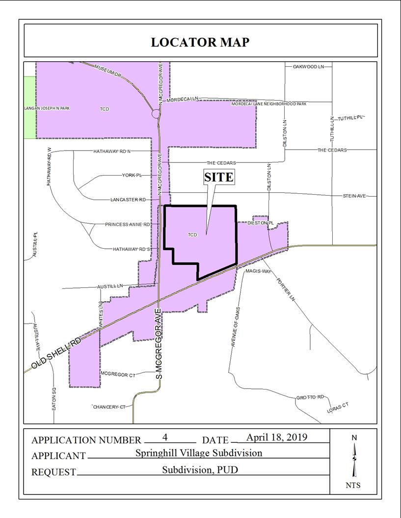
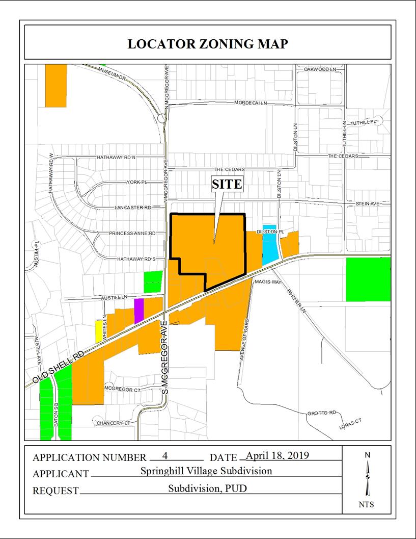
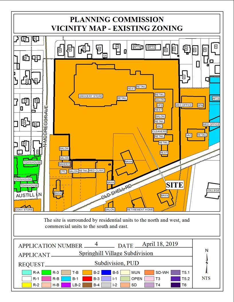
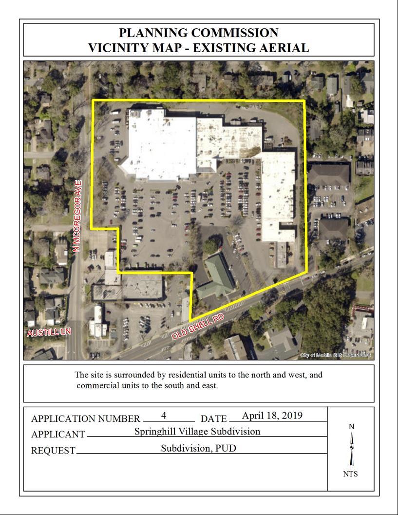
1 PLANNED UNIT DEVELOPMENT & SUBDIVISION STAFF REPORT Date: April 18, 2019 DEVELOPMENT NAME SUBDIVISION NAME Springhill Village Subdivision Springhill Village Subdivision LOCATION 4350, 4354, 4356, 4358, 4360, 4362, 4364, 4366 and 4376 Old Shell Road (North side of Old Shell Road, West of Dilston Lane, extending to the East side of North McGregor Avenue, North of Old Shell Road). CITY COUNCIL DISTRICT District 7 AREA OF PROPERTY 2 Lots / Acres CONTEMPLATED USE Planned Unit Development Approval to amend a previously approved Planned Unit Development to allow multiple buildings on a single building site, shared access and parking and reduced front yard setbacks to accommodate new businesses; and Subdivision Approval to create two legal lots of record. TIME SCHEDULE FOR DEVELOPMENT None given. ENGINEERING COMMENTS Subdivision: FINAL PLAT COMMENTS (should be addressed prior to submitting the FINAL PLAT for review and/or signature by the City Engineer): A. Provide all of the required information on the SUBDIVISION PLAT (i.e. signature blocks, signatures, certification statements, written legal description, required notes, legend, scale, bearings and distances) that is required by the current Alabama State Board of Licensure for Professional Engineers and Land Surveyors. B. Provide and label the monument set or found at each subdivision corner. C. Add street names to the vicinity map. D. Add a signature block for the Owner, Notary Public, Planning Commission, Traffic Engineer, and City Engineer. E. Provide the Surveyor s Certificate.
2 F. Provide the Surveyor s, Owner s (notarized), Planning Commission, and Traffic Engineering signatures. G. Add a note to the SUBDIVISION PLAT stating that as shown on the 1984 aerial photos Lots 1 & 2 will receive historical credit of impervious area towards stormwater detention requirement per Mobile City Code, Chapter 17, Storm Water Management and Flood Control. (Coordinate with City Engineering Department staff to establish the exact amount prior to the submittal of the FINAL PLAT for signature.) H. Add a note to the SUBDIVISION PLAT stating that a Land Disturbance permit will be required for any land disturbing activity in accordance with Mobile City Code, Chapter 17, Storm Water Management and Flood Control); the City of Mobile, Alabama Flood Plain Management Plan (1984); and, the Rules For Erosion and Sedimentation Control and Storm Water Runoff Control. I. Add a note to the Plat stating that the approval of all applicable federal, state, and local agencies (including all storm water runoff, wetland and floodplain requirements) will be required prior to the issuance of a Land Disturbance permit. J. Add a note that sidewalk is required to be constructed, and/or repaired, along the frontage of each lot, or parcel, at time of new development or construction, unless a sidewalk waiver is approved. K. Add a note to the plat stating that all proposed detention facilities, common areas, and wetlands shall be the responsibility of the Property Owner(s), and not the responsibility of the City of Mobile. L. Add a note to the plat stating that all easements shall remain in effect until vacated through the proper Vacation process. M. Provide a copy of the FINAL SUBDIVISION PLAT to the Engineering Dept. for review. No signatures are required on this drawing. N. After addressing all of the FINAL SUBDIVISION PLAT review comments by the Engineering Dept. provide the red-line markup, the ORIGINAL (with all other signatures) and one (1) copy of the revised original (signatures not required) of the revised Final Plat to the Engineering Department. Planned Unit Development: 1. Retain NOTES 1 7 shown on the PROPOSED SPRINGHILL VILLAGE REDEVELOPMENT (OPTION A) PUD site plan. 2. Show and label all proposed improvements. TRAFFIC ENGINEERING COMMENTS Site is limited to two curb cuts per street frontage with size, location and design to be approved by Traffic Engineering and conform to AASHTO standards. Any new on-site parking, including ADA handicap spaces, shall meet the minimum standards as defined in Section 64-6 of the City s Zoning Ordinance. Handicap parking spaces on site (north central near grocery store) do not illustrate the required access aisle. Modifications to include the aisles may slightly change the number of onsite parking spaces. Roadway widening may be necessary on McGregor Avenue to accommodate the relocation of the entrance to the site. Striping modifications will be required to restripe the turn lane to a two-way turn lane, now that the left turns into the site and onto Princess Anne will have to share the same lane to turn left
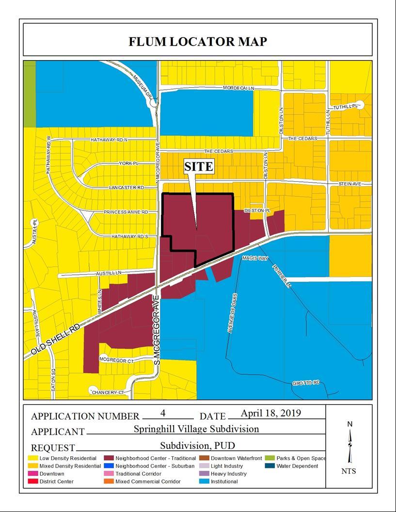
3 URBAN FORESTRY COMMENTS Property to be developed in compliance with state and local laws that pertain to tree preservation and protection on both city and private properties (State Act and City Code Chapters 57 and 64). Private removal of trees in the right-of-way will require approval of the Mobile Tree Commission. Removal of heritage trees from a commercial site will require a tree removal permit. FIRE DEPARTMENT COMMENTS All projects within the City Limits of Mobile shall comply with the requirements of the City of Mobile Fire Code Ordinance. (2012 International Fire Code). REMARKS The applicant is requesting Planned Unit Development Approval to amend a previously approved Planned Unit Development to allow multiple buildings on a single building site, shared access and parking and reduced front yard setbacks to accommodate new businesses; and Subdivision Approval to create two legal lots of record from three existing metes-and-bounds parcels. The site is located in Council District 7, and according to the applicant is served by public water and sanitary sewer. The subject site consists of the Springhill Village Shopping Center and the adjacent Regions Bank site. The applicant proposes to remove a small portion of the bank property from the bank and incorporate it into the shopping center via the subdivision. The site most recently appeared before the Commission at the October 4, 2018 meeting where a Planned Unit Development was approved to allow multiple buildings on a single building site, with shared access and parking to accommodate two new buildings. As the shopping center and bank shared access and parking in that PUD, and as the common internal property line between the two is now proposed to shift, the previously-approved PUD must be amended to address the change in the site plan and property boundaries. A parking lot reconfiguration within the shopping center is proposed in the current PUD application, but no new buildings beyond those approved in the previous PUD are proposed. No new development is proposed for the bank site. The site has been given a Traditional Neighborhood Center (NC) land use designation, per the recently adopted Future Land Use Plan and Map. The Future Land Use Plan and Map complements and provides additional detail to the Development Framework Maps in the Map for Mobile, adopted by the Planning Commission at its November 5, 2015 meeting. This land use designation applies to smaller hubs of mixed commercial, community, and recreational activity that cater to adjacent residential areas. Many of these centers exist today in some form. Therefore, the following common principles apply not just to the future development of new centers, but also to the redevelopment (wholesale or incremental) of existing centers. General Principles for Neighborhood Centers: NC should support a limited amount of commercial employment NC should incorporate some residential use, which may vary in type from detached single family, townhouse, accessory and live-work units in mixed use and low-rise multifamily structures
4 The residential density in NC designations ranging from 4 to 10 du/ac must be compatible in character with that of surrounding residential development, providing appropriate transitions in height, massing and other buffering from one land use district to the next. The retail and housing uses should merge around vibrant, compact, accessible nodes, located at key neighborhood intersections or along short road segments. The NC nodes should be connected to the surrounding neighborhood and nearby public uses (e.g., schools, parks, etc.) via well-designed sidewalks and complete streets. While the above-listed principles are common to all NC districts, the design attributes of neighborhood centers generally vary depending on whether a center is in a more traditional or more suburban context. Additional Attributes of Neighborhood Centers: NC in traditional contexts: These tend to be in those areas east of the Beltline and correspond to MxDR neighborhoods. In these NCs, buildings should orient to the street, with on-site parking typically pushed to the back of the site. The design qualities of the public realm are emphasized, including the provision of continuous sidewalks, tree canopy, pedestrian amenities, on-street parking and bicycle facilities where appropriate. NC in suburban contexts: These generally are located among the LDR land use designations in the areas west of the Beltline. Where they exist, these centers currently have a more pronounced vehicular orientation. Therefore, the emphasis is on retrofitting to improve internal walkability (e.g., through the addition of sidewalks, tree canopy, protection from the elements) and external connectivity to the surrounding areas (via sidewalks, paths and trails, street crossings, transit stops, etc.) and to increase the mix and density of uses (e.g., infill of outparcels, addition of housing, etc.). It should be noted that the Future Land Use Plan and Map components of the Map for Mobile Plan are meant to serve as a general guide, not a detailed lot and district plan. In many case the designation of the new Future Land Use Map may match the existing use of land, but in others the designated land use may differ from what is on the ground today. As such, the Future Land Use Plan and Map allows the Planning Commission and the City Council to consider individual cases based on additional information such as the classification request, the surrounding development, the timing of the request, and the appropriateness and compatibility of the proposed use and, where applicable, the zoning classification. Subdivision review examines the site with regard to promoting orderly development, protecting general health, safety and welfare, and ensuring that development is correlated with adjacent developments and public utilities and services, and to ensure that the subdivision meets the minimum standards set forth in the Subdivision Regulations for lot size, road frontage, lot configuration, etc. Planned Unit Development review examines the site with regard to its location to ensure that it is generally compatible with neighboring uses; that adequate access is provided without generating - 4 -
5 excess traffic along minor residential streets in residential districts outside the PUD; and, that natural features of the site are taken into consideration. PUD review also examines the design of the development to provide for adequate circulation within the development; to ensure adequate access for emergency vehicles; and, to consider and provide for protection from adverse effects of adjacent properties as well as provide protection of adjacent properties from adverse effects from the PUD. In pursuit of these purposes, the objectives to be met by a PUD are as follows: a) to encourage innovative and diversified design in building form and site development; b) flexibility, to permit greater flexibility in the location and arrangement of buildings and uses than is generally possible under district regulations; c) to encourage the most efficient and sustainable use of land, especially tracts in the inner part of the city that remain undeveloped or that are appropriate for re-development; d) to preserve and protect as urban amenities the natural features and characteristics of land; e) to encourage the provision of common open space through efficient site design; and, f) to encourage optimum use of available public utilities, streets and community facilities. PUD approval is site-plan specific, thus any changes to the site plan / Subdivision plat will require approval by the Planning Commission. Also, PUD approvals expire within one (1) year if no permits for the development are obtained. The applicant states the following concerning the applications: SUBDIVISION PUD The owners of Springhill Village Shopping Center (Lot 1) are purchasing the North feet of the Regions Bank property (Lot 2) to create additional parking spaces to allow for future expansion of the shopping center. This is a resubmittal of PUD from October 4th of This incorporates the approved variances obtained from BOA on November 5, It also incorporates the new boundary line per the subdivision application for Springhill village Subdivision being submitted herewith. It should be noted that, at the applicant s request, the previous PUD was reviewed under Section 64-3.H.(Traditional Center District)3.b.(Village Center Sub-district) of the Zoning Ordinance as opposed to the normal non-traditional Center District review process. The Regulating Plan for a Traditional Center District (TDC) allows for certain reductions in setbacks beyond the normal B-2 setbacks, and allows for more-relaxed parking ratios than normally required. It also has certain street frontage requirements, sidewalk width requirements, signage restrictions and entrance/exit drive restrictions. As certain aspects of the previous PUD did not conform with the Regulating Plan for the TCD, variance approvals were needed and granted by the Board of Zoning Adjustment at its November 2018 meeting to allow Reduced Building Frontage, Increased Access Drive Width and Sign Variances to allow a 41%+ building frontage along Old Shell Road, and a 46%+ building - 5 -
6 frontage along McGregor Avenue North; to allow a two-way access drive width of ; and to allow two pylon signs to remain on site in a Village Center Sub-district of a Traditional Center District overlay at the subject site. Site aspects approved under that variance are incorporated into the submitted plan for the current PUD review. As stated, the applicant proposes to acquire the Northern 33 of the Regions Bank property and incorporate it into the shopping center property via the subdivision. This would allow the shopping center parking to increase from the 486 spaces approved in the previous PUD to 512 in the proposed amended PUD. Other than modifying the shared access point between the two sites to a compliant size, no other site changes or new buildings are proposed beyond those of the previous PUD. The site has frontage on Old Shell Road and North McGregor Avenue, both of which are components of the Major Street Plan. However, as it is unlikely that frontage will be required for any future widening of either street, dedication will not be required along either street frontage. The proposed lots, as depicted, meet the minimum size requirements of the Subdivision Regulations. The lot size areas are labeled on the plat in both square feet and acres and should be retained on the Final Plat, or a table should be furnished on the Final Plat providing the same information. The PUD site plan provides the area for the shopping center only. Therefore, the site plan should be revised to label the area of the bank property in both square feet and acres, or a table should be furnished on the site plan providing the same information. The Regions Bank site is only outlined on the PUD site plan with very little specific site detail shown with regard to buildings, traffic aisles, front curb cuts, etc. Therefore, the over-all PUD site plan should be revised to also include site details for the bank property as shown for the shopping center property. The 25 minimum building setback line is depicted on the preliminary plat along both street frontages for both properties. However, as the Regulating Plan for the TCD allows for a front build-to line from zero to five feet back from the front property line, the Final Plat should be revised to indicate this setback along both street frontages for the shopping center property. The normal 25 minimum building setback line should remain along Old Shell Road for the bank property. The PUD site plan should be revised to indicate the setbacks as per the revised Final Plat. As the same new buildings are indicated as proposed under the previous PUD approval, and as the parking requirements are as per the TCD Regulating Plan, the site plan should be revised to provide a chart of parking calculations based on the ratio of one space per 450 square feet of gross floor area for general business uses, one space per 300 square feet of gross floor area for restaurant/lounge area, and no parking required for residential use, with all fractional numbers rounded up. No landscaping or tree planting is indicated on the site plan. As per the TCD Regulating Plan, 10% of the total building site being developed or redeveloped must be landscaped. As per the previous PUD approval, the site plan should be revised to provide landscaping and tree planting for 10% of the total site, to be coordinated with the Planning and Zoning staff prior to submittal
7 As no new development is proposed on the bank site, no landscaping plan would be required for that portion of the PUD. As revisions are required of the site plan, two copies of a revised PUD should be submitted to and approved by Planning and Zoning prior to signing of the Final Plat for the subdivision..recommendation Subdivision: Based upon the preceding, this application is recommended for Tentative Approval, subject to the following conditions: 1) retention of lot size labels in both square feet and acres on the Final Plat, or the furnishing of a table on the Final Plat providing the same information; 2) revision of the plat to indicate a zero to five-foot building setback line along both street frontages for Lot 1 (shopping center site); 3) retention of the 25 minimum building setback line along Old Shell Road for Lot 2 (bank site); 4) compliance with the Engineering comments: [FINAL PLAT COMMENTS (should be addressed prior to submitting the FINAL PLAT for review and/or signature by the City Engineer): A. Provide all of the required information on the SUBDIVISION PLAT (i.e. signature blocks, signatures, certification statements, written legal description, required notes, legend, scale, bearings and distances) that is required by the current Alabama State Board of Licensure for Professional Engineers and Land Surveyors. B. Provide and label the monument set or found at each subdivision corner. C. Add street names to the vicinity map. D. Add a signature block for the Owner, Notary Public, Planning Commission, Traffic Engineer, and City Engineer. E. Provide the Surveyor s Certificate. F. Provide the Surveyor s, Owner s (notarized), Planning Commission, and Traffic Engineering signatures. G. Add a note to the SUBDIVISION PLAT stating that as shown on the 1984 aerial photos Lots 1 & 2 will receive historical credit of impervious area towards stormwater detention requirement per Mobile City Code, Chapter 17, Storm Water Management and Flood Control. (Coordinate with City Engineering Department staff to establish the exact amount prior to the submittal of the FINAL PLAT for signature.). H. Add a note to the SUBDIVISION PLAT stating that a Land Disturbance permit will be required for any land disturbing activity in accordance with Mobile City Code, Chapter 17, Storm Water Management and Flood Control); the City of Mobile, Alabama Flood Plain Management Plan (1984); and, the Rules For Erosion and Sedimentation Control and Storm Water Runoff Control. I. Add a note to the Plat stating that the approval of all applicable federal, state, and local agencies (including all storm water runoff, wetland and floodplain requirements) will be required prior to the issuance of a Land Disturbance permit. J. Add a note that sidewalk is required to be constructed, and/or repaired, along the frontage of each lot, or parcel, at time of new development or construction, unless a sidewalk waiver is approved. K. Add a note to the plat stating that all proposed detention facilities, common areas, and wetlands shall be the responsibility of the Property Owner(s), and not the responsibility of the City of Mobile. L. Add a note to the plat stating that all easements shall remain in effect until vacated through the proper Vacation process. M. Provide a copy of the FINAL SUBDIVISION PLAT to the Engineering Dept. for review. No signatures are required on this drawing. N. After addressing all of the FINAL SUBDIVISION PLAT review comments by the Engineering Dept. provide the red-line markup, the ORIGINAL - 7 -
8 (with all other signatures) and one (1) copy of the revised original (signatures not required) of the revised Final Plat to the Engineering Department.]; 5) placement of a note on the Final Plat stating the Traffic Engineering comments: [Site is limited to two curb cuts per street frontage with size, location and design to be approved by Traffic Engineering and conform to AASHTO standards. Any new on-site parking, including ADA handicap spaces, shall meet the minimum standards as defined in Section 64-6 of the City s Zoning Ordinance. Handicap parking spaces on site (north central near grocery store) do not illustrate the required access aisle. Modifications to include the aisles may slightly change the number of onsite parking spaces. Roadway widening may be necessary on McGregor Avenue to accommodate the relocation of the entrance to the site. Striping modifications will be required to restripe the turn lane to a two-way turn lane, now that the left turns into the site and onto Princess Anne will have to share the same lane to turn left.]; 6) compliance with the Urban Forestry comments: [Property to be developed in compliance with state and local laws that pertain to tree preservation and protection on both city and private properties (State Act and City Code Chapters 57 and 64). Private removal of trees in the right-of-way will require approval of the Mobile Tree Commission. Removal of heritage trees from a commercial site will require a tree removal permit.]; 7) compliance with the Fire Department comments: [All projects within the City Limits of Mobile shall comply with the requirements of the City of Mobile Fire Code Ordinance. (2012 International Fire Code).]; and 8) submittal to and approval by Planning and Zoning of two (2) copies of a revised PUD site plan prior to signing the Final Plat. Planned Unit Development: Staff recommends the following Findings of Fact for Approval for the Planned Unit Development: a. the proposal promotes the objective of Creative design (to encourage innovative and diversified design in building form and site development), because it allows for multiple buildings with mixed uses on a single building site, shared access and parking between building sites, and reduced front yard setbacks, and allows for implementation of aspects of the Blueprint for Spring Hill plan; b. the proposal promotes the objective of Flexibility (to permit greater flexibility in the location and arrangement of buildings and uses than is generally possible under district regulations), because the amended site plan will allow for increased parking space on the shopping center site; c. the proposal promotes the objective of Efficient land use (to encourage the most efficient and sustainable use of land, especially tracts in the inner part of the city that remain undeveloped or that are appropriate for redevelopment), because the development will not require additional area to be incorporated into the site and will re-purpose existing site area; d. the proposal promotes the objective of Environment (to preserve and protect as urban amenities the natural features and characteristics of the land), because there will not be any expansion of site area; e. the proposal promotes the objective of Open space (to encourage the provision of common open space through efficient site design), because the proposed parking lot expansion is within an already-open area and will encompass only a small portion of the total site area; and - 8 -
9 f. the proposal promotes the objective of Public services (to encourage optimum use of available public utilities, streets and community facilities), because it is utilizing a site that is already developed that is already served with public infrastructure. Based upon the preceding, this application is recommended for approval subject to the following: 1) revision of the site plan to label both lots in both square feet and acres, or the furnishing of a table on the site plan providing the same information; 2) revision of the site plan to include site details for the bank site similar to those shown on the shopping center site; 3) revision of the site plan to indicate a zero to five-foot building setback line along both street frontages for Lot 1 (shopping center site); 4) revision of the site plan to indicate a 25 minimum building setback line along Old Shell Road for Lot 2 (bank site); 5) revision of the site plan to provide a chart of parking calculations based on the ratio of one space per 450 square feet of gross floor area for general business uses; one space per 300 square feet of gross floor area for restaurant/lounge use; and no parking required for residential use, with all fractional numbers rounded up; 6) revision of the site plan to provide landscaping and tree planting for 10% of the shopping center site (Lot 1), to be coordinated with the Planning and Zoning staff; 7) compliance with the Engineering comments: [1. Retain NOTES 1 7 shown on the PROPOSED SPRINGHILL VILLAGE REDEVELOPMENT (OPTION A) PUD site plan. 2. Show and label all proposed improvements.]; 8) placement of a note on the site plan stating the Traffic Engineering comments: [Site is limited to two curb cuts per street frontage with size, location and design to be approved by Traffic Engineering and conform to AASHTO standards. Any new on-site parking, including ADA handicap spaces, shall meet the minimum standards as defined in Section 64-6 of the City s Zoning Ordinance. Handicap parking spaces on site (north central near grocery store) do not illustrate the required access aisle. Modifications to include the aisles may slightly change the number of onsite parking spaces. Roadway widening may be necessary on McGregor Avenue to accommodate the relocation of the entrance to the site. Striping modifications will be required to restripe the turn lane to a two-way turn lane, now that the left turns into the site and onto Princess Anne will have to share the same lane to turn left.]; 9) compliance with the Urban Forestry comments: (Property to be developed in compliance with state and local laws that pertain to tree preservation and protection on both city and private properties (State Act and City Code Chapters 57 and 64). Private removal of trees in the right-of-way will require approval of the Mobile Tree Commission. Removal of heritage trees from a commercial site will require a tree removal permit.); 10) compliance with the Fire comments: [All projects within the City Limits of Mobile shall comply with the requirements of the City of Mobile Fire Code Ordinance. (2012 International Fire Code).]; 11) full compliance with all other municipal codes and ordinances; and 12) submittal to and approval by Planning and Zoning of two (2) copies of a revised PUD site plan prior to signing the Final Plat for the subdivision
10 - 10 -
11 - 11 -
12 - 12 -
13 - 13 -
14 - 14 -
15 - 15 -
16 - 16 -
17 - 17 -
18 - 18 -
BROADWAY THREE NOTCH ROAD SUBDIVISION
 # 3 SUB-000803-2018 BROADWAY THREE NOTCH ROAD SUBDIVISION Engineering Comments: FINAL PLAT COMMENTS (should be addressed prior to submitting the FINAL PLAT for review and/or signature by the City Engineer):
PLANNED UNIT DEVELOPMENT & SUBDIVISION STAFF REPORT August 18, 2016
 PLANNED UNIT DEVELOPMENT & SUBDIVISION STAFF REPORT August 18, 2016 DEVELOPMENT NAME SUBDIVISION NAME Mullinax Ford Subdivision Mullinax Ford Subdivision LOCATION CITY COUNCIL DISTRICT District 6 Southeast
THE CITY OF MOBILE, ALABAMA
 THE CITY OF MOBILE, ALABAMA LETTER OF DECISION March 9, 2018 Byrd Surveying, Inc. 2609 Halls Mill Road Mobile, AL 36606 Re: 4439 Rangeline Road (Northwest corner of Rangeline Road and Halls Mill Road).
PLANNED UNIT DEVELOPMENT & SUBDIVISION STAFF REPORT Date: July 20, 2017
 PLANNED UNIT DEVELOPMENT & SUBDIVISION STAFF REPORT Date: July 20, 2017 DEVELOPMENT NAME SUBDIVISION NAME LOCATION Rangeline Crossing III Subdivision Rangeline Crossing III Subdivision 5289 Halls Mill
HAWTHORNE PLACE SUBDIVISON, RESUBDIVISION OF LOT 15 REVISED
 # 10 SUB-000336-2017 HAWTHORNE PLACE SUBDIVISON, RESUBDIVISION OF LOT 15 REVISED Engineering Comments: FINAL PLAT COMMENTS (should be addressed prior to submitting the FINAL PLAT for review and/or signature
TULSA PARK ESTATES SUBDIVISION, RESUBDIVISION OF LOT 6
 TULSA PARK ESTATES SUBDIVISION, RESUBDIVISION OF LOT 6 Engineering Comments: FINAL PLAT COMMENTS (should be addressed prior to submitting the FINAL PLAT for review and/or signature by the City Engineer):
THE WHEELER BUILDING SUBDIVISION
 THE WHEELER BUILDING SUBDIVISION Engineering Comments: FINAL PLAT COMMENTS (should be addressed prior to submitting the FINAL PLAT for review and/or signature by the City Engineer): A. Provide all of the
PLANNED UNIT DEVELOPMENT & SUBDIVISION STAFF REPORT Date: September 15, 2016
 # 10 SUB2016-00089 PLANNED UNIT DEVELOPMENT & SUBDIVISION STAFF REPORT Date: September 15, 2016 NAME SUBDIVISION NAME LOCATION Lot 12 Laughlin Industrial Park Subdivision Lot 12 Laughlin Industrial Park
SUBDIVISION, PLANNED UNIT DEVELOPMENT, ZONING AMENDMENT, & SIDEWALK WAIVER STAFF REPORT Date: July 19, 2018
 SUBDIVISION, PLANNED UNIT DEVELOPMENT, ZONING AMENDMENT, & SIDEWALK WAIVER STAFF REPORT Date: July 19, 2018 NAME SUBDIVISION NAME LOCATION West Mobile Properties, LLC U.S. Machine Subdivision 556, 566,
WESTMINSTER PARK PLACE SUBDIVISION
 WESTMINSTER PARK PLACE SUBDIVISION Engineering Comments: FINAL PLAT COMMENTS (should be addressed prior to submitting the FINAL PLAT for review and/or signature by the City Engineer): A. Provide all of
ZONING AMENDMENT & SUBDIVISION STAFF REPORT Date: November 3, 2016
 ZONING AMENDMENT & SUBDIVISION STAFF REPORT Date: November 3, 2016 APPLICANT NAME SUBDIVISION NAME David Shumer 5955 Airport Subdivision CITY COUNCIL DISTRICT District 6 5955 Airport Boulevard, 754 Linlen
ZONING AMENDMENT & SUBDIVISION STAFF REPORT Date: July 9, 2015
 ZONING AMENDMENT & SUBDIVISION STAFF REPORT Date: July 9, 2015 APPLICANT NAME 2513 Dauphin Street, Inc. SUBDIVISION NAME Audubon Place Extension No. 3, Resubdivision of Lots 1-5 LOCATION 2513 Dauphin Street
ZONING AMENDMENT, PLANNED UNIT DEVELOPMENT & SUBDIVISION STAFF REPORT Date: August 8, 2013
 ZONING AMENDMENT, PLANNED UNIT DEVELOPMENT & SUBDIVISION STAFF REPORT Date: August 8, 2013 NAME SUBDIVISION NAME PV-Magnolia, LLC Twelve Trees Subdivision LOCATION 2860, 2862 and 2866 Pleasant Valley Road
WESTMINSTER PARK SUBDIVISION
 WESTMINSTER PARK SUBDIVISION Engineering Comments: FINAL PLAT COMMENTS (should be addressed prior to submitting the FINAL PLAT for review and/or signature by the City Engineer): A. Provide all of the required
JOHNNY S RV PARK SUBDIVISION
 # 11 SUB2016-00001 JOHNNY S RV PARK SUBDIVISION Engineering Comments: The following comments should be addressed prior to submitting the FINAL PLAT for acceptance and signature by the City Engineer: A.
DAUPHIN CREEK ESTATES SUBDIVISION
 # 12 SUB-000076-2017 DAUPHIN CREEK ESTATES SUBDIVISION Engineering Comments: FINAL PLAT COMMENTS (should be addressed prior to submitting the FINAL PLAT for review and/or signature by the City Engineer):
PLANNED UNIT DEVELOPMENT & SUBDIVISION STAFF REPORT Date: November 17, 2016
 PLANNED UNIT DEVELOPMENT & SUBDIVISION STAFF REPORT Date: November 17, 2016 DEVELOPMENT NAME SUBDIVISION NAME LOCATION Autonation Ford of Mobile Autonation Ford of Mobile Subdivision 901, 909, and 925
SUBDIVISION & PLANNING APPROVAL STAFF REPORT Date: December 1, 2016
 SUBDIVISION & PLANNING APPROVAL STAFF REPORT Date: December 1, 2016 APPLICANT NAME SUBDIVISION NAME DEVELOPMENT NAME LOCATION Board of Water and Sewer Commissioners of the City of Mobile Halls Mill Road
ALBA BEACH SUBDIVISION, RESUBDIVISION OF LOT 17
 ALBA BEACH SUBDIVISION, RESUBDIVISION OF LOT 17 Engineering Comments: FINAL PLAT COMMENTS (should be addressed prior to submitting the FINAL PLAT for acceptance and signature by the City Engineer): A.
DINKINS ESTATE FAMILY SUBDIVISION
 # 9 SUB2015-00122 DINKINS ESTATE FAMILY SUBDIVISION Engineering Comments: The following comments should be addressed prior to submitting the FINAL PLAT for acceptance and signature by the City Engineer:
ZONING AMENDMENT & SUBDIVISION STAFF REPORT Date: July 3, 2014
 ZONING AMENDMENT & SUBDIVISION STAFF REPORT Date: July 3, 2014 APPLICANT NAME SUBDIVISION NAME LOCATION Georgia Crown Distributing Subdivision Georgia Crown Distributing Subdivision Southwest corner of
ZONING AMENDMENT & SUBDIVISION STAFF REPORT Date: March 1, 2018
 #13 SUB-000406-2018 & ZON-000407-2018 ZONING AMENDMENT & SUBDIVISION STAFF REPORT Date: March 1, 2018 NAME SUBDIVISION NAME LOCATION Creekside @ Kooiman Dairy Creekside @ Kooiman Dairy Subdivision (South
THE CITY OF MOBILE, ALABAMA
 THE CITY OF MOBILE, ALABAMA LE 'I IER OF DECISION Kimberly Clark Mobile Operations 200 Africatown Blvd. Prichard, AL 36610 Re: 100 & 200 Africatown Boulevard (Northeast corner of Bay Bridge Road and Paper
MTC ALABAMA SUBDIVISION
 # 2 SUB-000370-2017 MTC ALABAMA SUBDIVISION Engineering Comments: FINAL PLAT COMMENTS (should be addressed prior to submitting the FINAL PLAT for review and/or signature by the City Engineer): A. Provide
ZONING AMENDMENT & SUBDIVISION STAFF REPORT Date: June 18, 2015
 ZONING AMENDMENT & SUBDIVISION STAFF REPORT Date: June 18, 2015 APPLICANT NAME SUBDIVISION NAME EAA LLC / Eryka Rogers Aaiden Place Subdivision LOCATION 2480 Government Boulevard (North side of Government
THE CITY OF MOBILE, ALABAMA
 THE CITY OF MOBILE, ALABAMA LETTER OF DECISION Dominion Senior Living of West Mobile, LLC 1200 Corporate Dr., St. 225 Birmingham, AL 35242 Re: 6924 Somerbv Lane (North terminus of Somerby Lane). Council
SUBDIVISION, PLANNING APPROVAL, & REZONING STAFF REPORT Date: June 4, 2015
 SUBDIVISION, PLANNING APPROVAL, & REZONING STAFF REPORT Date: June 4, 2015 APPLICANT NAME SUBDIVISION NAME DEVELOPMENT NAME LOCATION Board of Water & Sewer Commissioners of the City of Mobile MAWSS MLK
MOBILE TOWERS SUBDIVISION
 # 3 SUB2014-00100 MOBILE TOWERS SUBDIVISION Engineering Comments: The following comments should be addressed prior to submitting the FINAL PLAT for acceptance and signature by the City Engineer: 1) Provide
THE CI FY OF MOBILE, ALABAMA
 THE CI FY OF MOBILE, ALABAMA LETTER OF DECISION DewberryiPreble-Rish 9949 Bellaton Avenue Daphne, AL 36526 Re: Area bounded by Foxtail Drive, Lace Bark Drive and Whitebark Drive Council District 6 SUB-000323-2017
PLANNED UNIT DEVELOPMENT, SIDEWALK WAIVER, & SUBDIVISION STAFF REPORT Date: November 6, 2008
 PLANNED UNIT DEVELOPMENT, SIDEWALK WAIVER, & SUBDIVISION STAFF REPORT Date: November 6, 2008 DEVELOPMENT NAME SUBDIVISION NAME LOCATION Frascati Shops, Inc. Frascati Subdivision 1120 Paper Mill Road CITY
SUBDIVISION, PLANNED UNIT DEVELOPMENT, & REZONING STAFF REPORT Date: September 17, 2015
 SUBDIVISION, PLANNED UNIT DEVELOPMENT, & REZONING STAFF REPORT Date: September 17, 2015 APPLICANT NAME SUBDIVISION NAME DEVELOPMENT NAME LOCATION Daniel Clark Mack Manufacturing Subdivision, Resubdivision
AMENDMENT TO REGULATING PLAN & SUBDIVISION STAFF REPORT Date: December 15, 2016
 AMENDMENT TO REGULATING PLAN & SUBDIVISION STAFF REPORT Date: December 15, 2016 NAME SUBDIVISION NAME Gulf States Engineering- Mathew C. Roberts, PLS Precision Engineering Subdivision LOCATION CITY COUNCIL
SUBDIVISION, PLANNED UNIT DEVELOPMENT, & REZONING STAFF REPORT Date: March 23, 2017
 SUBDIVISION, PLANNED UNIT DEVELOPMENT, & REZONING STAFF REPORT Date: March 23, 2017 APPLICANT NAME SUBDIVISION NAME DEVELOPMENT NAME LOCATION Sarah & Michael Stashak Old Shell at Ashland Place Subdivision
PLANNED UNIT DEVELOPMENT & ZONING AMENDMENT STAFF REPORT Date: December 21, 2017
 # 14 PUD-000324-2017 & ZON-000326-2017 PLANNED UNIT DEVELOPMENT & ZONING AMENDMENT STAFF REPORT Date: December 21, 2017 APPLICANT NAME DEVELOPMENT NAME LOCATION Dewberry/Preble-Rish Longleaf Gates Subdivision,
McGowin Park, LLC. B-3, Community Business District
 # 10, 11, 12 SUB2014-00024 ZON2014-00500 ZON2014-00501 SUBDIVISION, PLANNED UNIT DEVELOPMENT (East), PLANNED UNIT DEVELOPMENT (West) STAFF REPORT Date: April 3, 2014 DEVELOPMENT NAME LOCATION McGowin Park,
MCGOWIN PARK EAST OF SATCHEL PAIGE SUBDIVISION, RESUBDIVISION OF
 # 14 SUB2015-00058 MCGOWIN PARK EAST OF SATCHEL PAIGE SUBDIVISION, RESUBDIVISION OF Engineering Comments: The following comments should be addressed prior to submitting the FINAL PLAT for acceptance and
PLANNED UNIT DEVELOPMENT STAFF REPORT Date: October 19, 2017
 PLANNED UNIT DEVELOPMENT STAFF REPORT Date: October 19, 2017 DEVELOPMENT NAME LOCATION Custom Boat Storage 3975 Demetropolis Road (East side of Demetropolis Road, 0.2± miles South of Halls Mill Road.)
APPLICANT NAME SUBDIVISION NAME DEVELOPMENT NAME LOCATION. CITY COUNCIL DISTRICT Council District 4 PRESENT ZONING PROPOSED ZONING
 SUBDIVISION, PLANNED UNIT DEVELOPMENT, PLANNING APPROVAL, ZONING AMENDMENT, & SIDEWALK WAIVER REQUEST STAFF REPORT Date: February 17, 2010 APPLICANT NAME SUBDIVISION NAME DEVELOPMENT NAME LOCATION David
ZONING AMENDMENT & SUBDIVISION STAFF REPORT Date: March 7, 2013
 # 4 & 5 SUB2012-00141 & ZON2012-03157 HOLDOVER ZONING AMENDMENT & SUBDIVISION STAFF REPORT Date: March 7, 2013 APPLICANT NAME SUBDIVISION NAME LOCATION Garrard Development Services, LLC Michigan & Bay
THE CITY OF MOBILE, ALABAMA
 THE CITY OF MOBILE, ALABAMA LETTER OF DECISION Dewberry I Preble-Rish 9949 Bellaton Avenue Daphne, AL 36526 Re: 6050 & 6086 Whitebark Drive (North side of Girby Road, 125'± East of Bristlecone Drive, extending
SUBDIVISION, PLANNED UNIT DEVELOPMENT, & PLANNING APPROVAL STAFF REPORT Date: February 1, 2007
 SUBDIVISION, PLANNED UNIT DEVELOPMENT, & PLANNING APPROVAL STAFF REPORT Date: February 1, 2007 DEVELOPMENT NAME SUBDIVISION NAME Pala Verde Mobile Home Park Subdivision Pala Verde Mobile Home Park Subdivision
THE CITY OF MOBILE, ALABAMA MOBILE Crry PLANNING COMMISSION
 THE CITY OF MOBILE, ALABAMA MOBILE Crry PLANNING COMMISSION LETTER OF DECISION MLK Avenue Redevelopment Corp. Attn: Michael Pierce P.O. Box 2204 Mobile, AL 36652 Re: Case #SUB2014-00040 (Subdivision) MLK
SUBDIVISION, PLANNED UNIT DEVELOPMENT, PLANNING APPROVAL, ZONING AMENDMENT, & SIDEWALK WAIVER REQUEST STAFF REPORT Date: February 17, 2010
 SUBDIVISION, PLANNED UNIT DEVELOPMENT, PLANNING APPROVAL, ZONING AMENDMENT, & SIDEWALK WAIVER REQUEST STAFF REPORT Date: February 17, 2010 APPLICANT NAME SUBDIVISION NAME DEVELOPMENT NAME LOCATION David
ZONING AMENDMENT, SUBDIVISION & SIDEWALK WAIVER REQUEST STAFF REPORT Date: November 16, 2006
 ZONING AMENDMENT, SUBDIVISION & SIDEWALK WAIVER REQUEST STAFF REPORT Date: November 16, 2006 NAME SUBDIVISION NAME Terhaar & Cronley Investment Partnership P & E Subdivision LOCATION 4210 and 4218 Halls
ZONING AMENDMENT, PLANNED UNIT DEVELOPMENT & SUBDIVISION STAFF REPORT Date: March 5, 2009
 ZONING AMENDMENT, PLANNED UNIT DEVELOPMENT & SUBDIVISION STAFF REPORT Date: March 5, 2009 NAME SUBDIVISION NAME LOCATION Kentress Morrisette Booker T. Washington Highlands Subdivision, First Addition,
ZONING AMENDMENT, PLANNED UNIT DEVELOPMENT & SUBDIVISION STAFF REPORT Date: September 15, 2011
 ZONING AMENDMENT, PLANNED UNIT DEVELOPMENT & SUBDIVISION STAFF REPORT Date: September 15, 2011 NAME SUBDIVISION NAME LOCATION Stratford, L.L.C. Grelot Office Park Subdivision North side of Grelot Road,
COCHRAN FAMILY RIVERSIDE ESTATE SUBDIVISION
 # 19 SUB2012-00111 COCHRAN FAMILY RIVERSIDE ESTATE SUBDIVISION Engineering Comments: The following comments should be addressed prior to review, acceptance and signature by the City Engineer: 1. Label/show
PLANNED UNIT DEVELOPMENT & SUBDIVISION STAFF REPORT Date: May 6, 2004
 # 3. & 4. File # ZON2004-00967 & SUB2004-00085 PLANNED UNIT DEVELOPMENT & SUBDIVISION STAFF REPORT Date: May 6, 2004 DEVELOPMENT NAME SUBDIVISION NAME Heron Lakes Subdivision, Phase One, Revised Lot 32
PLANNED UNIT DEVELOPMENT & SUBDIVISION STAFF REPORT Date: March 15, 2007
 PLANNED UNIT DEVELOPMENT & SUBDIVISION STAFF REPORT Date: March 15, 2007 DEVELOPMENT NAME SUBDIVISION NAME LOCATION Motormax Subdivision Motormax Subdivision 2917 and 2929 Government Boulevard (South side
ZONING AMENDMENT & PLANNED UNIT DEVELOPMENT STAFF REPORT Date: June 7, 2012
 ZONING AMENDMENT & PLANNED UNIT DEVELOPMENT STAFF REPORT Date: June 7, 2012 NAME DEVELOPMENT NAME LOCATION Mayo Blackmon Mayo Blackmon 1446 Navco Road & 2452 McLaughlin Drive. (North side of McLaughlin
HERON LANDING SUBDIVISION
 HERON LANDING SUBDIVISION Engineering Comments: Per FEMA guidelines, any development greater than 5 acres in size or subdivision 50 lots in size, requires a flood study. Width of drainage easement to be
KLUGE PLACE SUBDIVISION
 KLUGE PLACE SUBDIVISION Engineering Comments: Must comply with the Mobile County Flood Damage Prevention Ordinance. Development shall be designed to comply with the storm water detention and drainage facility
ZONING AMENDMENT, PLANNED UNIT DEVELOPMENT & PLANNING APPROVAL STAFF REPORT Date: June 7, 2007
 ZONING AMENDMENT, PLANNED UNIT DEVELOPMENT & PLANNING APPROVAL STAFF REPORT Date: June 7, 2007 NAME LOCATION Johnny Randall Cotton and Angela K. Cotton 4800 Tufts Road (West side of Tufts Road, 50 ± North
ZONING AMENDMENT & PLANNED UNIT DEVELOPMENT STAFF REPORT Date: July 5, 2012
 ZONING AMENDMENT & PLANNED UNIT DEVELOPMENT STAFF REPORT Date: July 5, 2012 NAME DEVELOPMENT NAME LOCATION Mayo Blackmon Mayo Blackmon 1446 Navco Road & 2452 McLaughlin Drive. (North side of McLaughlin
PLANNED UNIT DEVELOPMENT STAFF REPORT Date: August 20, 2015
 # 3 HOLDOVER Revised ZON2015-01733 PLANNED UNIT DEVELOPMENT STAFF REPORT Date: August 20, 2015 DEVELOPMENT NAME LOCATION Joseph N. Asarisi, P.E. North side of Airport Boulevard 212 ± West of Mckeena Court.
DAWES SWITCHING STATION SUBDIVISION
 DAWES SWITCHING STATION SUBDIVISION Engineering Comments: Must comply with the Mobile County Flood Damage Prevention Ordinance. Development shall be designed to comply with the storm water detention and
KRONER S MOBILE WEST COMMERCIAL BUSINESS PARK SUBDIVISION
 KRONER S MOBILE WEST COMMERCIAL BUSINESS PARK SUBDIVISION Engineering Comments: Must comply with the Mobile County Flood Damage Prevention Ordinance. Development shall be designed to comply with the storm
BETTA STOR-IT SUBDIVISION
 BETTA STOR-IT SUBDIVISION Engineering Comments: Must comply with all storm water and flood control ordinances. Any increase in impervious area in excess of 4,000 square feet will require detention. Any
SOUTHERN INDUSTRIAL PARK SUBDIVISION, LOT A, RESUBDIVISION OF LOTS 7 & 8
 SOUTHERN INDUSTRIAL PARK SUBDIVISION, LOT A, RESUBDIVISION OF LOTS 7 & 8 Engineering Comments: Need to increase width of existing easement to include an area at least 20 from the top of the existing ditch,
In order to permit maximum applicability of the PUD District, PUD-1 and PUD-2 Districts are hereby created.
 ARTICLE III. PUD ned Unit Development Overlay District 205-128. Purpose. The PUD ned Unit Development Overlay District is intended to provide flexibility in the design of planned projects; to encourage
ZONING AMENDMENT STAFF REPORT Date: September 15, 2016
 ZONING AMENDMENT STAFF REPORT Date: September 15, 2016 NAME LOCATION Clear Water, LLC 3490 Hurricane Bay Road (Northeast corner of Hurricane Bay Road and Hurricane Bay Lane) CITY COUNCIL DISTRICT District
ZONING AMENDMENT, & SUBDIVISION STAFF REPORT Date: July 24, 2008
 ZONING AMENDMENT, & SUBDIVISION STAFF REPORT Date: July 24, 2008 APPLICANT NAME SUBDIVISION NAME Remax Realty Professionals Star Motel Subdivision LOCATION 2005 and 2009 Douglas Lane (Southwest corner
BAY FOREST PARK SUBDIVISION, RESUBDIVISION OF LOTS 6 & 7 AND BAY FOREST PARK SUBDIVISION LOT 10, OF THE RESUBDIVISON OF LOTS 9 & 10
 BAY FOREST PARK SUBDIVISION, RESUBDIVISION OF LOTS 6 & 7 AND BAY FOREST PARK SUBDIVISION LOT 10, OF THE RESUBDIVISON OF LOTS 9 & 10 Engineering Comments: Must comply with the Mobile County Flood Damage
TERRY POIROUX FAMILY DIVISION SUBDIVISION
 TERRY POIROUX FAMILY DIVISION SUBDIVISION Engineering Comments: Must comply with the Mobile County Flood Damage Prevention Ordinance. Development shall be designed to comply with the storm water detention
STONE HEDGE SUBDIVISION, UNIT 1, RESUBDIVISION OF LOT 40 & WEST COMMON AREA
 # 5 SUB-000498-2018 STONE HEDGE SUBDIVISION, UNIT 1, RESUBDIVISION OF LOT 40 & WEST COMMON AREA Engineering Comments: Must comply with the Mobile County Flood Damage Prevention Ordinance. Development shall
PLANNED UNIT DEVELOPMENT (East), PLANNED UNIT DEVELOPMENT (West) STAFF REPORT Date: September 18, 2014
, PLANNED UNIT DEVELOPMENT (West) STAFF REPORT Date: September 18, 2014") PLANNED UNIT DEVELOPMENT (East), PLANNED UNIT DEVELOPMENT (West) STAFF REPORT Date: September 18, 2014 DEVELOPMENT NAME LOCATION McGowin Park, LLC PLANNED UNIT DEVELOPMENT (East) 1401 Satchel Paige Drive
PLANNED UNIT DEVELOPMENT (East), PLANNED UNIT DEVELOPMENT (West) STAFF REPORT Date: September 18, 2014 DEVELOPMENT NAME LOCATION McGowin Park, LLC PLANNED UNIT DEVELOPMENT (East) 1401 Satchel Paige Drive
# 14 SUB CANAL SUBDIVISION
 CANAL SUBDIVISION Engineering Comments: Label each Lot showing the required minimum finished floor elevation (MFFE). It appears that Lots 2, 3 & 4 are located in the AE Flood Zone; add a note to the plat
PENNY LAKES SUBDIVISION
 PENNY LAKES SUBDIVISION Engineering Comments: A portion of the site may be located within the J.B. Converse watershed, the primary drinking water supply for the Mobile Area Water and Sewer System. Consultation
MOBILE CITY PLANNING COMMISSION LETTER OF DECISION. June 3, 2011
 MOBILE CITY PLANNING COMMISSION LETTER OF DECISION P.O. Box 421 Mobile, AL 36601 Re: Case #SUB2011-00029 (Subdivision) Alabama West Subdivision, Unit Four 2600 McVay Drive North (North side of McVay Drive
# 1 HOLDOVER Revised SUB CANAL SUBDIVISION
 CANAL SUBDIVISION Engineering Comments: Label each Lot showing the required minimum finished floor elevation (MFFE). It appears that Lots 2, 3 & 4 are located in the AE Flood Zone; add a note to the plat
DEER RIVER COMMERCIAL PARK SUBDIVISION
 DEER RIVER COMMERCIAL PARK SUBDIVISION Engineering Comments: Must comply with the Mobile County Flood Damage Prevention Ordinance. Development shall be designed to comply with the storm water detention
Planning Department Oconee County, Georgia
 Planning Department Oconee County, Georgia STAFF REPORT REZONE CASE #: 6985 DATE: October 31, 2016 STAFF REPORT BY: Andrew C. Stern, Planner APPLICANT NAME: Williams & Associates, Land Planners PC PROPERTY
PROVISION POINTE SUBDIVISION
 PROVISION POINTE SUBDIVISION Engineering Comments: Must comply with the Mobile County Flood Damage Prevention Ordinance. Development shall be designed to comply with the storm water detention and drainage
TURTLE CREEK SUBDIVISION, PHASE THREE
 TURTLE CREEK SUBDIVISION, PHASE THREE Engineering Comments: Must comply with the Mobile County Flood Damage Prevention Ordinance. Development shall be designed to comply with the storm water detention
THE BLUFFS AT CYPRESS CREEK SUBDIVISION, PHASE ONE
 THE BLUFFS AT CYPRESS CREEK SUBDIVISION, PHASE ONE Engineering Comments: Shipyard Road shall be constructed to City Standard up through proposed Cypress Park Drive. Show Minimum FFE on plans and plat.
AMELIA LAKE SUBDIVISON, PHASES 1-2
 # 1 HOLDOVER Revised SUB2014-00089 AMELIA LAKE SUBDIVISON, PHASES 1-2 Engineering Comments: Must comply with the Mobile County Flood Damage Prevention Ordinance. Development shall be designed to comply
ZONING AMENDMENT, & SUBDIVISION STAFF REPORT Date: May 17, 2007
 ZONING AMENDMENT, & SUBDIVISION STAFF REPORT Date: May 17, 2007 APPLICANT NAME SUBDIVISION NAME LOCATION Christopher J. Nix, Agent Mobile Central Subdivision 2570, 2590, & 2598 Government Boulevard (Northeast
SECTION 16. "PUD" PLANNED UNIT DEVELOPMENT OVERLAY DISTRICT
 SECTION 6. "PUD" PLANNED UNIT DEVELOPMENT OVERLAY DISTRICT Subsection. Purpose. This district is established to achieve the coordinated integration of land parcels and large commercial and retail establishments
ARTICLE 9 SPECIFICATIONS FOR DOCUMENTS TO BE SUBMITTED
 ARTICLE 9 SPECIFICATIONS FOR DOCUMENTS TO BE SUBMITTED SECTION 950 GENERALLY All applications shall be properly signed and filed by the owner or, with the owner s specific written consent, a contract purchaser
ORDINANCE WHEREAS, the adoption of this Ordinance shall not be construed as an admission that the aforesaid claim has merit or is correct; and
 ORDINANCE 12-24 AN ORDINANCE OF THE CITY OF WINTER GARDEN, FLORIDA, REPEALING ORDINANCE 12-02 AND REPLACING IT WITH THE AMENDMENTS TO ARTICLE V OF CHAPTER 118 OF THE WINTER GARDEN CODE OF ORDINANCES CONTAINED
ORDINANCE NOW THEREFORE, BE IT ENACTED BY THE CITY COMMISSION OF THE CITY OF WINTER GARDEN, FLORIDA, AS FOLLOWS:
 ORDINANCE 12-02 AN ORDINANCE OF THE CITY OF WINTER GARDEN, FLORIDA, AMENDING ARTICLE V OF CHAPTER 118 OF THE WINTER GARDEN CODE OF ORDINANCES ENTITLED PLANNED UNIT DEVELOPMENTS CREATING URBAN VILLAGE PLANNED
PORT CITY COMMERCE PARK SUBDIVISION
 # 4 SUB2015-00019 PORT CITY COMMERCE PARK SUBDIVISION Engineering Comments: Must comply with the Mobile County Flood Damage Prevention Ordinance. Development shall be designed to comply with the storm
Staff Report: Date: Applicant: Property Identification: Acreage of Request: Current Zoning of Requested Area: Requested Action: Attached:
 Staff Report: Completed by Jeff Palmer Director of Planning & Zoning Date: November 7, 2018, Updated November 20, 2018 Applicant: Greg Smith, Oberer Land Developer agent for Ronald Montgomery ET AL Property
AUTUMNDALE SUBDIVISION, RESUBDIVISION OF LOTS
 AUTUMNDALE SUBDIVISION, RESUBDIVISION OF LOTS 100-102 Engineering Comments: Road shall be constructed per City standards and according to the City s street acceptance process. Cul-de sac approval subject
Draft Zoning Changes for the 2nd Planning Board Public Hearing, January 22, 2018.
 Draft Zoning Changes for the 2nd Planning Board Public Hearing, January 22, 2018. No changes were made at the 1st Public Hearing. Proposed wording for the 1 st Public Hearing in red, eliminated text in
ARTICLE 15 - PLANNED UNIT DEVELOPMENT
 Section 15.1 - Intent. ARTICLE 15 - PLANNED UNIT DEVELOPMENT A PUD, or Planned Unit Development, is not a District per se, but rather a set of standards that may be applied to a development type. The Planned
Operating Standards Attachment to Development Application
 Planning & Development Services 2255 W Berry Ave. Littleton, CO 80120 Phone: 303-795-3748 Mon-Fri: 8am-5pm www.littletongov.org Operating Standards Attachment to Development Application 1 PLANNED DEVELOPMENT
Medical Marijuana Special Exception Use Information
 Medical Marijuana Special Exception Use Information The Special Exception Use information below is a modified version of the Unified Development Code. It clarifies the current section 5:104 Special Exceptions
PLANNED DEVELOPMENT DISTRICT STANDARDS. Cadence Site
 PLANNED DEVELOPMENT DISTRICT STANDARDS Cadence Site A Planned Development District 1. Statement of General Facts, Conditions and Objectives Property Size: Approximately 57.51 Acres York County Tax Map
NOBLE DRIVE EAST SUBDIVISION
 NOBLE DRIVE EAST SUBDIVISION Engineering Comments: Must comply with the Mobile County Flood Damage Prevention Ordinance. Development shall be designed to comply with the storm water detention and drainage
Staff Report: Date: Applicant: Property Identification: Acreage of Request: Current Zoning of Requested Area: Requested Action: Attached:
 Staff Report: Completed by Jeff Palmer Director of Planning & Zoning Date: November 7, 2018 Applicant: Greg Smith, Oberer Land Developer agent for Ronald Montgomery ET AL Property Identification: Frontage
Cover Letter with Narrative Statement
 Cover Letter with Narrative Statement March 31, 2017 rev July 27, 2017 RE: Rushton Pointe Residential Planned Unit Development Application for Public Hearing for RPUD Rezone PL2015 000 0306 Mr. Eric Johnson,
Charter Township of Garfield Grand Traverse County
 Charter Township of Garfield Grand Traverse County 3848 VETERANS DRIVE TRAVERSE CITY, MICHIGAN 49684 PH: (231) 941-1620 FAX: (231) 941-1588 GUIDE FOR THE SUBMISSION OF AN APPLICATION FOR SITE PLAN REVIEW
DEVELOPMENT DEPARTMENT STAFF REPORT THE PARK AT 5 TH
 DEVELOPMENT DEPARTMENT STAFF REPORT ARB Meeting Date: July 3, 2018 Item #: _PZ2018-293_ THE PARK AT 5 TH Request: Site Address: Project Name: Parcel Number: Applicant: Proposed Development: Current Zoning:
MASTER SUBDIVISION FINAL PLAT APPLICATION Town of Apex, North Carolina
 MASTER SUBDIVISION FINAL PLAT APPLICATION Town of Apex, North Carolina This document is a public record under the North Carolina Public Records Act and may be published to the Town s website or disclosed
CITY OF OCOEE LAND DEVELOPMENT CODE SUFFICIENCY TABLE WITH NOTES
 CITY OF OCOEE LAND DEVELOPMENT CODE SUFFICIENCY TABLE WITH NOTES The Sufficiency Table is a checklist to help identify the types of information and documentation needed for various types of projects. The
MINOR SUBDIVISION FINAL PLAT APPLICATION Town of Apex, North Carolina
 MINOR SUBDIVISION FINAL PLAT APPLICATION Town of Apex, North Carolina This document is a public record under the North Carolina Public Records Act and may be published on the Town s website or disclosed
SUBJECT PARCEL(S) Property Owner(s) TMS Number Approximate Acreage Carolina Park Development, LLC
 Property Owner(s) TMS Number Approximate Acreage Carolina Park Development, LLC") Staff Report Special Planning Commission Meeting November 19, 2014 For reference, the Zoning Code and Land Development Regulations are available online. AGENDA ITEM 5c. SKETCH PLAN APPROVAL REQUEST: Request
Staff Report Special Planning Commission Meeting November 19, 2014 For reference, the Zoning Code and Land Development Regulations are available online. AGENDA ITEM 5c. SKETCH PLAN APPROVAL REQUEST: Request
DEVELOPMENT DEPARTMENT STAFF REPORT STAFF REPORT PUD/DCI BAINBRIDGE MIXED-USE DEVELOPMENT
 DEVELOPMENT DEPARTMENT STAFF REPORT Meeting Date: October 12, 2017 Item #: _PZ-2017-170_ STAFF REPORT PUD/DCI BAINBRIDGE MIXED-USE DEVELOPMENT Request: Project Name: Planned Unit Development (PUD)/ Development
ARTICLE 14 PLANNED UNIT DEVELOPMENT (PUD) DISTRICT
 DISTRICT") ARTICLE 14 PLANNED UNIT DEVELOPMENT (PUD) DISTRICT Section 14.01 Intent. It is the intent of this Article to allow the use of the planned unit development (PUD) process, as authorized by the Michigan Zoning
ARTICLE 14 PLANNED UNIT DEVELOPMENT (PUD) DISTRICT Section 14.01 Intent. It is the intent of this Article to allow the use of the planned unit development (PUD) process, as authorized by the Michigan Zoning