Committed to Service
|
|
|
- Maud Montgomery
- 5 years ago
- Views:
Transcription


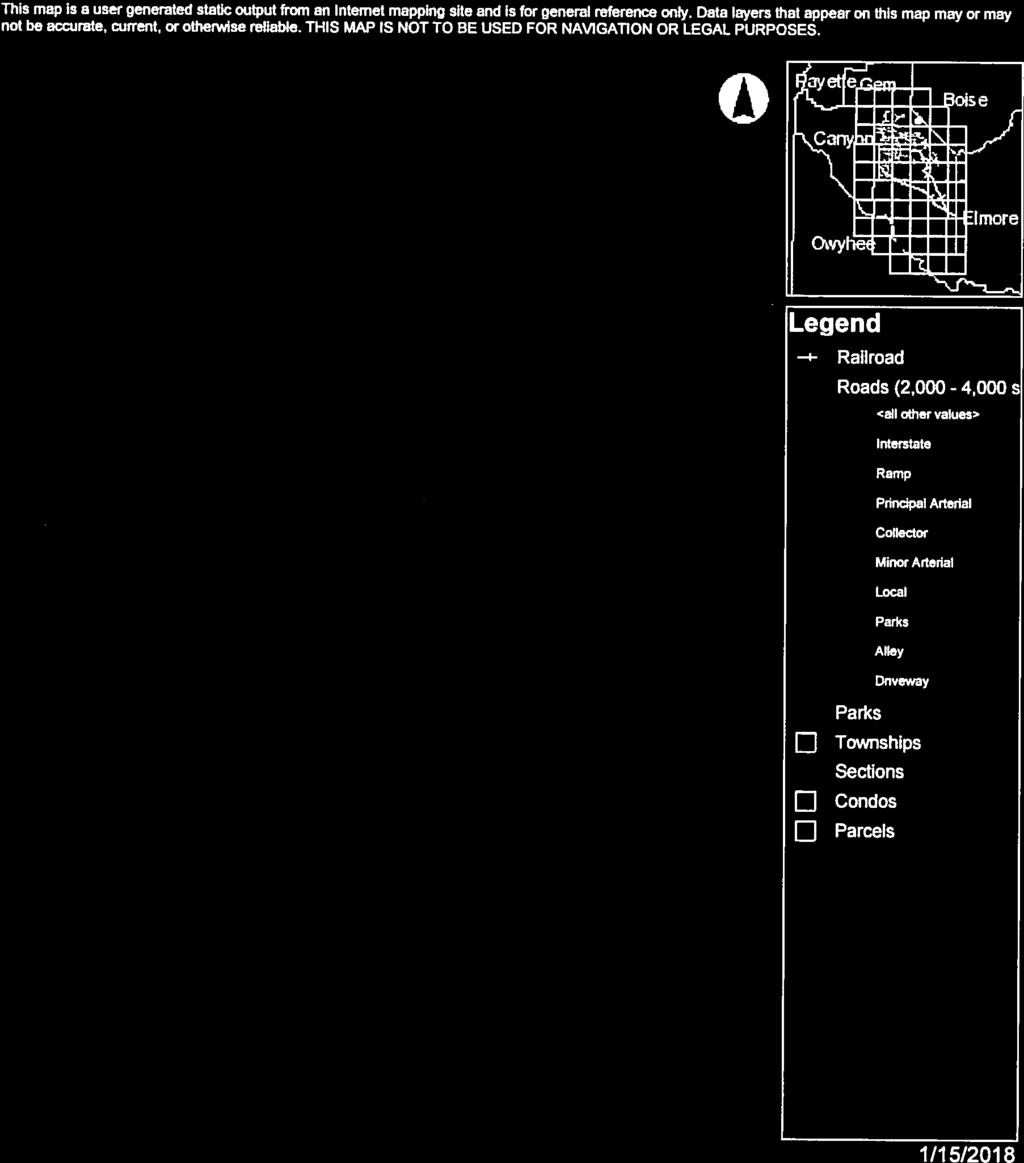
1 Committed to Service Sara M. Baker, President Rebecca W. Arnold, Vice President Jim D. Hansen, Commissioner Kent Goldthorpe, Commissioner Paul Woods, Commissioner January 16, 2018 Development Services TO: FROM: ACHD Commission Mindy Wallace, AICP SUBJECT: Shadow Valley Estates Subdivision Staff Report for January 24, 2018 Commission Meeting Executive Summary The applicant is requesting approval of a zoning ordinance map amendment, rezone, and preliminary plat application to allow for the development of 11 lots on 118 acres. The site is located on the west side of SH-55 across from Shadow Valley Golf Course. This item is on the regular agenda due to staff recommended modification to the Master Street Map, and was originally heard on January 10, 2018 and at the request of the Commission was deferred 2 weeks to the January 24, 2018 Commission meeting. During the January 10th hearing the Commission questioned whether a public or private street should be constructed in this location. Ada County code doesn't allow for a private road to connect two public streets or to intersect another private road. All but 2 acres of the site is already zoned Rural Residential (RR), which would allow the applicant to develop 10 lots without rezoning any property. The proposed rural large lot development is consistent with the existing land use plan for this area. Information regarding the maintenance costs will be provided during the presentation. Since originally hearing this application the applicant and Ada County have provide additional information. Recommendation Staff recommends approval of the staff report, as written. Attachment(s): Memo from the Applicant Memo from Ada County Staff Report COMPASS Checklist


2


3


4

5


6


7


8
, the regional long-range")


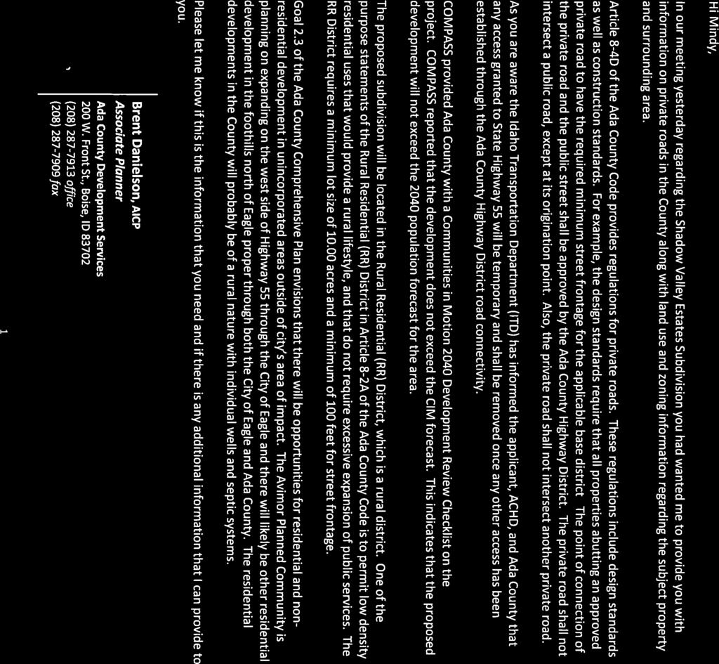
9 Communities in Motion 2040 Development Review The Community Planning Association of Southwest Idaho (COMPASS) is the metropolitan planning organization (MPO) for Ada and Canyon Counties. COMPASS has developed this review as a tool for local governments to evaluate whether land developments are consistent with the goals of Communities in Motion 2040 (CIM 2040), the regional long-range transportation plan for Ada and Canyon Counties. This checklist is not intended to be prescriptive, but rather a guidance document based on CIM 2040 goals. Development Name: Shadow Valley Estates Agency: Ada County CIM Vision Category: Foothills New households: 11 New jobs: 0 Exceeds CIM forecast: No CIM Corridor: Highway 55 Pedestrian level of stress: R Bicycle level of stress: R Housing within 1 mile: 33 Jobs within 1 mile: 46 Jobs/Housing Ratio: 1.4 Nearest police station: >4 miles Nearest fire station: >4 miles Farmland consumed: No Farmland within 1 mile: 1,281 acres Farmland Value: N/A Nearest bus stop: >4 miles Nearest public school: >4 miles Nearest public park: 2.4 miles Nearest grocery store: 2.5 miles Level of Stress considers facility type, number of vehicle lanes, and speed. Roads with G or PG ratings better support bicyclists and pedestrians of all ages and comfort levels. A good jobs/housing balance a ratio between 1 and 1.5 reduces traffic congestion. Higher numbers indicate the need for more housing and lower numbers indicate an employment need. Developments within 1.5 miles of police and fire stations ensure that emergency services are more efficient and reduce the cost of these important public services. Farmland contributes to the local economy, creates additional jobs, and provides food security to the region. Development in farm areas decreases the productivity and sustainability of farmland. Residents who live or work less than ½ mile from critical services have more transportation choices. Walking and biking reduces congestion by taking cars off the road, while supporting a healthy and active lifestyle. Recommendations The proposal requests direct access to State Highway 55, which is the #17 priority in the Communities in Motion 2040 plan. State Highway 55 is a primary route for people commuting between the Treasure Valley and Boise County and provides access to resorts and outdoor destinations in Boise and Valley Counties. Additional access points reduce the efficiency of the corridor. Nearby services, such as schools, parks, emergency services, grocery, and other stores are likely accessed only by vehicle and there are no plans for public transportation to this location. More information about COMPASS and Communities in Motion 2040: Web: info@compassidaho.org More information about the development review process:

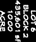
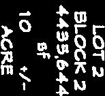
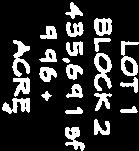
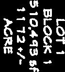
10 Development Services Department Project/File: Lead Agency: Site address: Shadow Valley Estates/ APP / DA/HD/S/ZC This is a zoning ordinance map amendment, rezone, and preliminary plat application to allow for the development of an 11 lot subdivision on 118 acres. Ada County Commission Hearing: January 24, 2018 Regular Agenda West side of SH-55 across from Shadow Valley Golf Course Applicant: Wendy Shrief JUB Engineers 250 S. Beechwood Avenue STE 201 Boise, ID Representative: Same as Above Staff Contact: A. Findings of Fact Mindy Wallace, AICP Phone: mwallace@achdidaho.org 1. Description of Application: The applicant is requesting approval of a zoning ordinance map amendment, rezone, and preliminary plat application to allow for the development of 11 lots on 118 acres. The zoning ordinance map amendment and rezone is to rezone 2.8 acres from RP to RR zoning. 2. Description of Adjacent Surrounding Area: Direction Land Use Zoning North Rural preservation RP South Rural residential/preservation RR/RP East Rural residential RR West Rural residential RR 3. Site History: ACHD has not previously reviewed this site for a development application. 4. Transit: Transit services are not available to serve this site. 5. New Center Lane Miles: The proposed development includes 0.65 centerline miles of new public road. 1 DRAFT Shadow Valley Estates
11 6. Impact Fees: There will be an impact fee that is assessed and due prior to issuance of any building permits. The assessed impact fee will be based on the impact fee ordinance that is in effect at that time. 7. Capital Improvements Plan (CIP)/ Integrated Five Year Work Plan (IFYWP): There are currently no roadways, bridges or intersections in the general vicinity of the project that are currently in the Integrated Five Year Work Plan (IFYWP) or the District s Capital Improvement Plan (CIP). The intersection of Beacon Light Road and SH-55 is listed in the CIP to be widened to 5- lanes on the north leg, 6-lanes on the south, and 5-lanes on the west leg, and signalized between 2031 and B. Traffic Findings for Consideration 1. Trip Generation: This development is estimated to generate 105 vehicle trips per day; 11 additional vehicle trips per hour in the PM peak hour, based on the Institute of Transportation Engineers Trip Generation Manual, 9 th edition. 2. Condition of Area Roadways Traffic Count is based on Vehicles per hour (VPH) Roadway Frontage Functional Classification Principal **SH-55 2,750 N/A N/A N/A Arterial * Acceptable level of service for a two-lane principal arterial is E (690 VPH). * Acceptable level of service for a three-lane principal arterial is E (880 VPH). ** ACHD does not set level of service thresholds for State Highways. 3. Average Daily Traffic Count (VDT) Average daily traffic counts are based on ACHD s most current traffic counts. The average daily traffic count for SH-55 at the Dry Creek Counter was 8,929 in September of C. Findings for Consideration PM Peak Hour Traffic Count PM Peak Hour Level of Service Existing Plus Project 1. State Highway 55 (SH-55) SH-55 is under the jurisdiction of the Idaho Transportation Department (ITD). The applicant, Ada County, and ITD should work together to determine if additional right-of-way or improvements are necessary on SH-55. Staff Comments/Recommendations: The applicant has proposed to construct a temporary public street connection onto SH-55 to provide access to the site. ITD has indicated that any access allowed on to SH-55 will be temporary and will be removed once other access becomes available via the extension of public stub streets (see attachment 3). ITD has also indicated that the temporary access will be allowed to serve only the 11 single family building lots proposed as part of this development application. 2. The Northwest Foothills Transportation Plan and Master Street Map On December 22, 2008 the ACHD Commission adopted the Northwest Foothills Transportation Study (NWFTS). The plan was prepared in response to development pressure in the Northwest 2 DRAFT Shadow Valley Estates
12 foothills. The plan was prepared in coordination with ACHD, The City of Eagle, Ada County, and various other agencies. The study functions as a policy guide for the developing and improving the transportation system as development occurs in this area. The NWFTS identified a preferred network of arterial and collector roadways for corridor preservation and to be constructed as development occurs. The roadway network identified in the study was subsequently incorporated in the ACHD s Master Street Map, which serves as a planning tool that works in concert with ACHD s partner agencies comprehensive plans. ACHD s Master Street Map (MSM) shows a future collector roadway extending from SH-55 through the site stubbing to the northwest. Staff has recommended a modification of the MSM for the collector roadway proposed to extend through the site, as ITD will not allow a permanent access to SH-55 (see attachment 4). In lieu of the collector roadway staff has recommended the construction of a local street, Sunrise Valley Drive, which would have temporary access onto SH- 55. The local street is proposed to stub to adjacent parcels which would be served by the collector roadway providing connectivity and opportunities for the roadways to be extended as area parcels develop. Future Foothills Roadway Network Collector Roadway 3 DRAFT Shadow Valley Estates


13 Master Street Map Collectors = Blue Proposed Local Street Network = Yellow/Orange For Illustrative purposes only. Staff recommends approval of the modification to the MSM to eliminate the collector roadway and construct a local street network in its place. Staff s recommendation is due to the fact that ITD will not allow a permanent access onto SH-55 in this location and has limited the temporary access to only 11 residential lots. Although the NWFTS and MSM only identify the arterial and collector roadways a local street network was always anticipated and is noted in the NWFTS. The proposed development is 4 DRAFT Shadow Valley Estates
14 consistent with Ada County s Rural Residential (RR) Districts, which permits low density residential uses that would provide a rural lifestyle, they require a minimum lots size of 10 acres and a minimum of 100-feet of public street frontage. 3. Sunrise Valley Drive & Woods Gulch Road a. Existing Conditions: There are no local roadways within the site. b. Policy: Local Roadway Policy: District Policy states that the developer is responsible for improving all local street frontages adjacent to the site regardless of whether or not access is taken to all of the adjacent streets. Rural Street Section: District policy requires rural developments with lot sizes of 5- acres or greater per dwelling provide a minimum 24-foot pavement width, with additional 3- foot gravel shoulders and borrow ditches on each side. This street section does not require the construction of curbs, gutters, or sidewalks. c. Applicant s Proposal: The applicant has proposed to construct new local streets, Sunrise Valley Drive and Woods Gulch Road, as 24-foot wide rural local streets with 3-foot gravel shoulders and barrow ditches on each side of the roadway within 50-feet of right-of-way. Retaining walls are proposed on some sections of the roadway and are proposed to be located outside of the right-of-way. d. Staff Comments/Recommendations: The applicant s proposal meets District policy, as all of the lots are greater than 5 acres in size, and should be approved, as proposed; with the exception of the right-of-way dedication between SH-55 and Woods Gulch Road and the retaining walls located outside of the right-of-way. All of the structural elements of the roadway including retaining walls should be patted as right-of-way or be placed in a right-of-way easement. ITD has indicated that the approach for Sunrise Valley Drive onto SH-55 will be temporary and will be closed in the future when other access becomes available via the extension of public stub streets. Because of this staff recommends that the applicant provide a temporary rightof-way easement for Sunrise Valley Drive between SH-55 and Woods Gulch Road. This would allow the easement to be released when the approach onto SH-55 is closed. The Eagle Fire District has indicated that this approach should remain as a private emergency access only driveway when the temporary public right-of-way easement is released. The applicant should work with ITD to restrict the driveway to emergency access only when other access becomes available via the extension of public streets. 4. Stub Streets a. Existing Conditions: There are no stub streets to the site. b. Policy: Stub Street Policy: District policy states that stub streets will be required to provide circulation or to provide access to adjoining properties. Stub streets will conform with the requirements described in Section except a temporary cul-de-sac will not be required if the stub street has a length no greater than 150-feet. A sign shall be installed at the terminus of the stub street stating that, "THIS ROAD WILL BE EXTENDED IN THE FUTURE. In addition, stub streets must meet the following conditions: A stub street shall be designed to slope towards the nearest street intersection within the proposed development and drain surface water towards that intersection; unless an alternative storm drain system is approved by the District. 5 DRAFT Shadow Valley Estates
15 The District may require appropriate covenants guaranteeing that the stub street will remain free of obstructions. Temporary Dead End Streets Policy: District policy requires that the design and construction for cul-de-sac streets shall apply to temporary dead end streets. The temporary cul-de-sac shall be paved and shall be the dimensional requirements of a standard cul-de-sac. The developer shall grant a temporary turnaround easement to the District for those portions of the cul-de-sac which extend beyond the dedicated street right-of-way. In the instance where a temporary easement extends onto a buildable lot, the entire lot shall be encumbered by the easement and identified on the plat as a non-buildable lot until the street is extended. The District will consider alternatives to the standard cul-de-sac turnaround on a case-by-case basis. This will be based on turning area, drainage, maintenance considerations and the written approval of the agency providing emergency fire service for the area where the development is located. c. Applicant Proposal: The applicant has proposed to construct one stub street to the north, Sunrise Valley Drive and one stub street to the west, Woods Gulch Road. Due to the topography the applicant has proposed to construct T-type turnarounds with a turnaround easement at the terminus of the stub streets. d. Staff Comments/Recommendations: The applicant s proposal to construct one stub street to the north and one stub street to the west meets District policy and should be approved, as proposed. The applicant should be required to install a sign at the terminus of the each stub street stating that, "THIS ROAD WILL BE EXTENDED IN THE FUTURE. Staff recommends a modification of ACHD s Temporary Dead End Streets Policy, to allow for the T-type turnarounds to be constructed, as proposed. Staff s recommendation is due to the topography. The T-type turnarounds should be paved and the applicant should be required to provide written fire department approval for use of the T-type turnarounds prior to ACHD s signature on the first final plat. 5. Driveways 5.1 Sunrise Valley Drive a. Existing Conditions: Sunrise Valley Drive is not yet construction within the site. b. Policy: Driveway Location Policy: District policy requires driveways located near intersections to be located a minimum of 75-feet (measured centerline-to-centerline) from the nearest street intersection. Successive Driveways: District Policy states that successive driveways away from an intersection shall have no minimum spacing requirements for access points along a local street, but the District does encourage shared access points where appropriate. Driveway Width Policy: District policy states that where vertical curbs are required, residential driveways shall be restricted to a maximum width of 20-feet and may be constructed as curb-cut type driveways. Driveway Paving Policy: Graveled driveways abutting public streets create maintenance problems due to gravel being tracked onto the roadway. In accordance with District policy, , the applicant should be required to pave the driveway its full width and at least 30-feet into the site beyond the edge of pavement of the roadway. c. Applicant s Proposal: The applicant has proposed to construct 8 driveways onto Sunrise Valley Drive to access the site. 6 DRAFT Shadow Valley Estates
16 d. Staff Comments/Recommendations: The applicant s proposal to construct 8 driveways onto Sunrise Valley Drive meets District policy and should be approved, as proposed. The applicant should be required to pave all of the driveways their full width at least 30-feet into the site beyond the edge of Sunrise Valley Drive. The driveways are restricted to a maximum width of 20-feet. 6. Tree Planters Tree Planter Policy: Tree Planter Policy: The District s Tree Planter Policy prohibits all trees in planters less than 8-feet in width without the installation of root barriers. Class II trees may be allowed in planters with a minimum width of 8-feet, and Class I and Class III trees may be allowed in planters with a minimum width of 10-feet. 7. Landscaping Landscaping Policy: A license agreement is required for all landscaping proposed within ACHD right-of-way or easement areas. Trees shall be located no closer than 10-feet from all public storm drain facilities. Landscaping should be designed to eliminate site obstructions in the vision triangle at intersections. District Policy requires a 40-foot vision triangle and a 3-foot height restriction on all landscaping located at an uncontrolled intersection and a 50-foot offset from stop signs. Landscape plans are required with the submittal of civil plans and must meet all District requirements prior to signature of the final plat and/or approval of the civil plans. 8. Other Access Staff recommends that direct lot access onto SH-55 be prohibited and that Ada County or ITD require it to be noted on the final plat. D. Site Specific Conditions of Approval 1. Comply with the requirements of Ada County and ITD for the SH-55 frontage. 2. Construct a temporary approach onto SH-55 for Sunrise Valley Drive, as permitted by ITD. 3. Construct Sunrise Valley Drive, with 24-feet of pavement with 3-foot gravel shoulders and barrow ditches on each side of the roadway within a temporary right-of-way easement from SH-55 north to Wood Gulch Road. 4. Construct Sunrise Valley Drive, with 24-feet of pavement with 3-foot gravel shoulders and barrow ditches on each side of the roadway within 50-feet of right-of-way from Wood Gulch Road north. 5. All of the structural elements of the public streets shall be located within platted right-of-way, or placed within a right-of-way easement. 6. Construct Wood Gulch Road, with 24-feet of pavement with 3-foot gravel shoulders and barrow ditches on each side of the roadway within 50-feet of right-of-way. 7. Construct one stub street to the north, Sunrise Valley Drive, as proposed. Install a sign at the terminus of the stub street stating that, "THIS ROAD WILL BE EXTENDED IN THE FUTURE. Construct a paved T-type turnaround at the terminus of the stub street. A temporary turnaround easement shall encompass the entire turnaround. Provide written fire department approval for use of the T-type turnaround prior to ACHD s signature on the first final plat. 8. Construct one stub street to the west, Woods Gulch Road, as proposed. Install a sign at the terminus of the stub street stating that, "THIS ROAD WILL BE EXTENDED IN THE FUTURE. Construct a paved T-type turnaround at the terminus of the stub street. A temporary turnaround easement shall encompass the entire turnaround. Provide written fire department approval for use of the T-type turnaround prior to ACHD s signature on the first final plat. 7 DRAFT Shadow Valley Estates
17 9. Construct 8 driveways onto Sunrise Valley Drive, as proposed. Pave all 8 of the driveways their full width at least 30-feet into the site beyond the edge of Sunrise Valley Drive. The driveways are restricted to a maximum width of 20-feet. 10. Payment of impact fees is due prior to issuance of a building permit. 11. Comply with all Standard Conditions of Approval. E. Standard Conditions of Approval 1. All proposed irrigation facilities shall be located outside of the ACHD right-of-way (including all easements). Any existing irrigation facilities shall be relocated outside of the ACHD right-of-way (including all easements). 2. Private Utilities including sewer or water systems are prohibited from being located within the ACHD right-of-way. 3. In accordance with District policy, , the applicant may be required to update any existing non-compliant pedestrian improvements abutting the site to meet current Americans with Disabilities Act (ADA) requirements. The applicant s engineer should provide documentation of ADA compliance to District Development Review staff for review. 4. Replace any existing damaged curb, gutter and sidewalk and any that may be damaged during the construction of the proposed development. Contact Construction Services at (with file number) for details. 5. A license agreement and compliance with the District s Tree Planter policy is required for all landscaping proposed within ACHD right-of-way or easement areas. 6. All utility relocation costs associated with improving street frontages abutting the site shall be borne by the developer. 7. It is the responsibility of the applicant to verify all existing utilities within the right-of-way. The applicant at no cost to ACHD shall repair existing utilities damaged by the applicant. The applicant shall be required to call DIGLINE ( ) at least two full business days prior to breaking ground within ACHD right-of-way. The applicant shall contact ACHD Traffic Operations in the event any ACHD conduits (spare or filled) are compromised during any phase of construction. 8. Utility street cuts in pavement less than five years old are not allowed unless approved in writing by the District. Contact the District s Utility Coordinator at (with file numbers) for details. 9. All design and construction shall be in accordance with the ACHD Policy Manual, ISPWC Standards and approved supplements, Construction Services procedures and all applicable ACHD Standards unless specifically waived herein. An engineer registered in the State of Idaho shall prepare and certify all improvement plans. 10. Construction, use and property development shall be in conformance with all applicable requirements of ACHD prior to District approval for occupancy. 11. No change in the terms and conditions of this approval shall be valid unless they are in writing and signed by the applicant or the applicant s authorized representative and an authorized representative of ACHD. The burden shall be upon the applicant to obtain written confirmation of any change from ACHD. 12. If the site plan or use should change in the future, ACHD Planning Review will review the site plan and may require additional improvements to the transportation system at that time. Any change in the planned use of the property which is the subject of this application, shall require the applicant to comply with ACHD Policy and Standard Conditions of Approval in place at that time unless a waiver/variance of the requirements or other legal relief is granted by the ACHD Commission. 8 DRAFT Shadow Valley Estates

18 F. Conclusions of Law 1. The proposed site plan is approved, if all of the Site Specific and Standard Conditions of Approval are satisfied. 2. ACHD requirements are intended to assure that the proposed use/development will not place an undue burden on the existing vehicular transportation system within the vicinity impacted by the proposed development. G. Attachments 1. Vicinity Map 2. Site Plan 3. ITD Comments 4. Request to Modify the Master Street Map 5. Utility Coordinating Council 6. Development Process Checklist 7. Request for Reconsideration Guidelines VICINITY MAP 9 DRAFT Shadow Valley Estates
19 SITE PLAN 10 DRAFT Shadow Valley Estates
20 ITD Comments 11 DRAFT Shadow Valley Estates
21 12 DRAFT Shadow Valley Estates
22 13 DRAFT Shadow Valley Estates
23 Request to Modify the Master Street Map 14 DRAFT Shadow Valley Estates
24 Ada County Utility Coordinating Council Developer/Local Improvement District Right of Way Improvements Guideline Request Purpose: To develop the necessary avenue for proper notification to utilities of local highway and road improvements, to help the utilities in budgeting and to clarify the already existing process. 1) Notification: Within five (5) working days upon notification of required right of way improvements by Highway entities, developers shall provide written notification to the affected utility owners and the Ada County Utility Coordinating Council (UCC). Notification shall include but not be limited to, project limits, scope of roadway improvements/project, anticipated construction dates, and any portions critical to the right of way improvements and coordination of utilities. 2) Plan Review: The developer shall provide the highway entities and all utility owners with preliminary project plans and schedule a plan review conference. Depending on the scale of utility improvements, a plan review conference may not be necessary, as determined by the utility owners. Conference notification shall also be sent to the UCC. During the review meeting the developer shall notify utilities of the status of right of way/easement acquisition necessary for their project. At the plan review conference each company shall have the right to appeal, adjust and/or negotiate with the developer on its own behalf. Each utility shall provide the developer with a letter of review indicating the costs and time required for relocation of its facilities. Said letter of review is to be provided within thirty calendar days after the date of the plan review conference. 3) Revisions: The developer is responsible to provide utilities with any revisions to preliminary plans. Utilities may request an updated plan review meeting if revisions are made in the preliminary plans which affect the utility relocation requirements. Utilities shall have thirty days after receiving the revisions to review and comment thereon. 4) Final Notification: The developer will provide highway entities, utility owners and the UCC with final notification of its intent to proceed with right of way improvements and include the anticipated date work will commence. This notification shall indicate that the work to be performed shall be pursuant to final approved plans by the highway entity. The developer shall schedule a preconstruction meeting prior to right of way improvements. Utility relocation activity shall be completed within the times established during the preconstruction meeting, unless otherwise agreed upon. Notification to the Ada County UCC can be sent to: 50 S. Cole Rd. Boise 83707, or Visit iducc.com for notification information. 15 DRAFT Shadow Valley Estates
25 Development Process Checklist Items Completed to Date: Submit a development application to a City or to Ada County The City or the County will transmit the development application to ACHD The ACHD Planning Review Section will receive the development application to review The Planning Review Section will do one of the following: Send a No Review letter to the applicant stating that there are no site specific conditions of approval at this time. Write a Staff Level report analyzing the impacts of the development on the transportation system and evaluating the proposal for its conformance to District Policy. Write a Commission Level report analyzing the impacts of the development on the transportation system and evaluating the proposal for its conformance to District Policy. Items to be completed by Applicant: For ALL development applications, including those receiving a No Review letter: The applicant should submit one set of engineered plans directly to ACHD for review by the Development Review Section for plan review and assessment of impact fees. (Note: if there are no site improvements required by ACHD, then architectural plans may be submitted for purposes of impact fee assessment.) The applicant is required to get a permit from Construction Services (ACHD) for ANY work in the right-ofway, including, but not limited to, driveway approaches, street improvements and utility cuts. Pay Impact Fees prior to issuance of building permit. Impact fees cannot be paid prior to plan review approval. DID YOU REMEMBER: Construction (Non-Subdivisions) Driveway or Property Approach(s) Submit a Driveway Approach Request form to ACHD Construction (for approval by Development Services & Traffic Services). There is a one week turnaround for this approval. Working in the ACHD Right-of-Way Four business days prior to starting work have a bonded contractor submit a Temporary Highway Use Permit Application to ACHD Construction Permits along with: a) Traffic Control Plan b) An Erosion & Sediment Control Narrative & Plat, done by a Certified Plan Designer, if trench is >50 or you are placing >600 sf of concrete or asphalt. Construction (Subdivisions) Sediment & Erosion Submittal At least one week prior to setting up a Pre-Construction Meeting an Erosion & Sediment Control Narrative & Plan, done by a Certified Plan Designer, must be turned into ACHD Construction to be reviewed and approved by the ACHD Stormwater Section. Idaho Power Company Vic Steelman at Idaho Power must have his IPCO approved set of subdivision utility plans prior to Pre-Con being scheduled. Final Approval from Development Services is required prior to scheduling a Pre-Con. 16 DRAFT Shadow Valley Estates
26 Request for Reconsideration of Commission Action 1. Request for Reconsideration of Commission Action: A Commissioner, a member of ACHD staff or any other person objecting to any final action taken by the Commission may request reconsideration of that action, provided the request is not for a reconsideration of an action previously requested to be reconsidered, an action whose provisions have been partly and materially carried out, or an action that has created a contractual relationship with third parties. a. Only a Commission member who voted with the prevailing side can move for reconsideration, but the motion may be seconded by any Commissioner and is voted on by all Commissioners present. If a motion to reconsider is made and seconded it is subject to a motion to postpone to a certain time. b. The request must be in writing and delivered to the Secretary of the Highway District no later than 11:00 a.m. 2 days prior to the Commission s next scheduled regular meeting following the meeting at which the action to be reconsidered was taken. Upon receipt of the request, the Secretary shall cause the same to be placed on the agenda for that next scheduled regular Commission meeting. c. The request for reconsideration must be supported by written documentation setting forth new facts and information not presented at the earlier meeting, or a changed situation that has developed since the taking of the earlier vote, or information establishing an error of fact or law in the earlier action. The request may also be supported by oral testimony at the meeting. d. If a motion to reconsider passes, the effect is the original matter is in the exact position it occupied the moment before it was voted on originally. It will normally be returned to ACHD staff for further review. The Commission may set the date of the meeting at which the matter is to be returned. The Commission shall only take action on the original matter at a meeting where the agenda notice so provides. e. At the meeting where the original matter is again on the agenda for Commission action, interested persons and ACHD staff may present such written and oral testimony as the President of the Commission determines to be appropriate, and the Commission may take any action the majority of the Commission deems advisable. f. If a motion to reconsider passes, the applicant may be charged a reasonable fee, to cover administrative costs, as established by the Commission. 17 DRAFT Shadow Valley Estates
Committed to Service
 Committed to Service Paul Woods, President Rebecca W. Arnold, Vice President Sara M. Baker, Commissioner Jim D. Hansen, Commissioner Kent Goldthorpe, Commissioner August 25, 2017 Development Services TO:
May 21, ACHD Board of Commissioners Stacey Yarrington, Planner II DRH /DRH
 Development Services Department May 21, 2013 TO: FROM: SUBJECT: ACHD Board of Commissioners Stacey Yarrington, Planner II DRH13-00106/DRH13-00108 Executive Summary: This is a design review application
Date: March 16, Jake Centers ERD, LLC P.O. Box 1610 Eagle, ID Elevation Ridge Subdivision (SUB & PUD ) Street Address
 Street Address") Rebecca W. Arnold, President Sara M. Baker, Vice President John S. Franden, Commissioner Carol A. McKee, Commissioner David L. Case, Commissioner Date: March 16, 2012 To: Jake Centers ERD, LLC P.O. Box
Rebecca W. Arnold, President Sara M. Baker, Vice President John S. Franden, Commissioner Carol A. McKee, Commissioner David L. Case, Commissioner Date: March 16, 2012 To: Jake Centers ERD, LLC P.O. Box
Executive Summary: This is a preliminary plat to construct 8 residential lots and 2 commons lots with a private road on 3.87-acres in Meridian, Idaho.
 Development Services Department DATE: July 7, 2015 TO: FROM: SUBJECT: ACHD Board of Commissioners Stacey Yarrington, Planner III Kentucky Villas/ MPP15-0012/ PP15-009 Executive Summary: This is a preliminary
SUB /CAR /PUD
 Development Services Department Project/File: Lead Agency: Site address: Balntyre Court Subdivision/BPP16-0036/ SUB16-00066/CAR16-00035/PUD16-00040 This is a rezone, planned unit development, and subdivision
Committed to Service
 Committed to Service Kent Goldthorpe, President Paul Woods, Vice President Rebecca W. Arnold, Commissioner Sara M. Baker, Commissioner Jim D. Hansen, Commissioner July 18, 2016 Development Services TO:
Date: August 29, Dave Scaggs (sent via ) Summit Development Inc th Ave. Rd. #384 Nampa, ID 83686
 Summit Development Inc th Ave. Rd. #384 Nampa, ID 83686") Sara M. Baker, President John S. Franden, Vice President Rebecca W. Arnold, Commissioner Mitchell A. Jaurena, Commissioner Jim Hansen, Commissioner Date: August 29, 2013 To: Dave Scaggs (sent via email)
Sara M. Baker, President John S. Franden, Vice President Rebecca W. Arnold, Commissioner Mitchell A. Jaurena, Commissioner Jim Hansen, Commissioner Date: August 29, 2013 To: Dave Scaggs (sent via email)
If you have any questions, please feel free to contact me at (208)
") Sara M. Baker, President John S. Franden, Vice President Rebecca W. Arnold, Commissioner Mitchell A. Jaurena, Commissioner Jim Hansen, Commissioner Date: March 21, 2013 To: Subject: Hornet Construction
Sara M. Baker, President John S. Franden, Vice President Rebecca W. Arnold, Commissioner Mitchell A. Jaurena, Commissioner Jim Hansen, Commissioner Date: March 21, 2013 To: Subject: Hornet Construction
#1 (CAR /SUB )
") Development Services Department Project/File: Lead Agency: Site address: Fork South #1 (CAR14-00009/SUB14-00024) The applicant is requesting annexation, rezone and preliminary plat approvals for a 52-lot
Development Services Department Project/File: Lead Agency: Site address: Fork South #1 (CAR14-00009/SUB14-00024) The applicant is requesting annexation, rezone and preliminary plat approvals for a 52-lot
3. The preliminary plats were approved on March 27, 2014 and August 14, 2014.
 Jim D. Hansen, President Sara M. Baker, Vice President Rebecca W. Arnold, Commissioner Kent Goldthorpe, Commissioner Paul Woods, Commissioner February 12, 2015 Development Services Department To: From:
BOI / DRH Albertsons grocery market and fueling center & pad sites
 Paul Woods, President Rebecca W. Arnold, Vice President Sara M. Baker, Commissioner Jim D. Hansen, Commissioner Kent Goldthorpe, Commissioner March 28, 2017 To: Mark Palmer Albertsons Companies 250 E.
Right-of-Way & Development Services Planning Review Division Committed to Service This application is approved at the staff level on February 1, 2006.
 Right-of-Way & Development Services Planning Review Division Committed to Service This application is approved at the staff level on February 1, 2006. Tech Review for this item was held with the applicant
Committed to Service
 Development Services Department Committed to Service June 23, 2015 TO: FROM: SUBJECT: ACHD Board of Commissioners Mindy Wallace, AICP Planner III Linder Apartments - EAG15-0005/ CPA-01-15/A-01-15/RZ-04-15
Committed to Service
 Committed to Service Sara M. Baker, President Rebecca W. Arnold, Vice President Jim D. Hansen, Commissioner Kent Goldthorpe, Commissioner Paul Woods, Commissioner February 28, 2018 Development Services
Subdivision Staff Report
 Subdivision Staff Report Subdivision Name Coldstream File Number SUB06-00040 Subdivision Approval Preliminary Plat Lead Agency Boise City Annexation Date December 9, 1974 Comp. Plan Complies Public Hearing
Subdivision Staff Report
 Subdivision Staff Report Subdivision Name Toli Park Subdivision File Number SUB07-00035 Approval Preliminary Plat Lead Agency Boise City Annexation Date December 30, 1987 Comp. Plan Complies Public Hearing
Let me know if I need to bring you any other documentation for this withdrawl. Thanks!
 >>> david benoit 11/27/2007 10:00 AM >>> Dave, I am set to be heard on the Cranston Corner Subdivision on December 4th in front of City council. I have sold this property and am requesting
SECTION 7000 LAND DEVELOPMENT REQUIREMENTS
 SECTION 7000 LAND DEVELOPMENT REQUIREMENTS 7000 LAND DEVELOPMENT REQUIREMENTS... 1 7001 LEGISLATIVE AUTHORITY... 1 7001.1 LAND DEVELOPMENT... 1 7001.1.1 Title 40, Idaho Code... 1 7001.1.2 Idaho Code 40-1415
Time Extension Staff Report
 Time Extension Staff Report Subdivision Name Therrin Subdivision File Number SUB06-00020 Approval Time Extension for Lead Agency Boise City Certification Signature of Boise City Engineer Annexation Date
Subdivision Staff Report
 Subdivision Staff Report Subdivision Name Honeymoon Cove Subdivision File Number SUB08-00005 Approval Preliminary/ Final Plat Lead Agency Boise City Annexation Date December 30, 2004 Comp. Plan Complies
Time Extension Staff Report
 Time Extension Staff Report Subdivision Name Lunara Subdivision File Number SUB07-00019 Approval Time Extension for Lead Agency Boise City Certification Signature of Boise City Engineer Annexation Date
Subdivision Staff Report
 Subdivision Staff Report Subdivision Name Sunnyridge Subdivision File Number SUB07-00007 Approval Preliminary Plat Lead Agency Ada County Annexation Date NA Comp. Plan Complies (With Conditions of Approval)
SUB / Diamante Subdivision / Northside Management
 SU15-00062 / Diamante Subdivision / Northside Management Summary: Subdivision application for a Preliminary Plat consisting of 20 buildable lots and 3 common lots. Prepared y: Todd Tucker, Senior Planner
a. provide for the continuation of collector streets and thoroughfare streets between adjacent subdivisions;
 Section 7.07. Intent The requirements of this Section are intended to provide for the orderly growth of the Town of Holly Springs and its extra-territorial jurisdiction by establishing guidelines for:
Subdivision Staff Report
 Subdivision Staff Report Subdivision Name Madera Creek File Number SUB06-00068 Subdivision Approval Final Plat Lead Agency Boise City Annexation Date December 9, 1974 Comp. Plan Complies Public Hearing
M-43 CORRIDOR OVERLAY ZONE
 ARTICLE 26.00 M-43 CORRIDOR OVERLAY ZONE Section 26.01 Findings A primary function of the M-43 state highway is to move traffic through the Township and to points beyond. As the primary east-west arterial
ARTICLE IV: DEVELOPMENT STANDARDS
 ARTICLE IV: DEVELOPMENT STANDARDS IV-53 409 PRIVATE STREETS A private street means any way that provides ingress to, or egress from, property by means of vehicles or other means, or that provides travel
BYRON TOWNSHIP ZONING APPLICATION
 BYRON TOWNSHIP ZONING APPLICATION Phone: (616) 878-9104 * Fax: (616) 878-3980 * Website: www.byrontownship.org This application will not be accepted if incomplete. APPLICATION FOR & REQUIRED COPIES Private
Subdivision Staff Report
 Subdivision Staff Report Subdivision Name Greenfield Park File Number SUB06-00110 Subdivision Approval Preliminary/Final Plat Lead Agency Boise City Annexation Date December 9, 1974 Comp. Plan Complies
Location: The subject property is located at the northeast corner of S. Holden Lane and E. Boise Avenue.
 Subdivision Staff Report Subdivision Name Tianna Park File Number SUB11-00008 Approval Preliminary Plat Lead Agency Boise City Annexation Date December 19, 1977 Comp. Plan Complies Public Meeting Date
Section Preliminary Plat Checklist and Application Forms
 Section 201 - Preliminary Plat Checklist and Application Forms PRELIMINARY SUBDIVISION PLAT REVIEW PROCESS CHART PRELIMINARY SUBDIVISION PLAT APPLICATION PRELIMINARY PLAT REVIEW CHECKLIST CITY OF NAMPA
Draft Model Access Management Overlay Ordinance
 Draft Model Access Management Overlay Ordinance This model was developed using the City of Hutchinson and the Trunk Highway 7 corridor. The basic provisions of this model may be adopted by any jurisdiction
ARTICLE 24 PRIVATE ROAD, SHARED PRIVATE DRIVEWAY AND ACCESS EASEMENT STANDARDS
 ARTICLE 24 PRIVATE ROAD, SHARED PRIVATE DRIVEWAY AND ACCESS EASEMENT STANDARDS SECTION 24.00 INTENT AND PURPOSE The standards of this Article provide for the design, construction and maintenance of private
WRITTEN DECISION OF THE HAYDEN CITY COUNCIL REGARDING MAPLE GROVE PRELIMINARY SUBDIVISION APPLICATION (SUB-0013) HAYDEN SIGNATURE, LLC
 HAYDEN SIGNATURE, LLC") WRITTEN DECISION OF THE HAYDEN CITY COUNCIL REGARDING MAPLE GROVE PRELIMINARY SUBDIVISION APPLICATION (SUB-0013) HAYDEN SIGNATURE, LLC Application of Hayden Signature, LLC, an Idaho limited liability company,
WRITTEN DECISION OF THE HAYDEN CITY COUNCIL REGARDING MAPLE GROVE PRELIMINARY SUBDIVISION APPLICATION (SUB-0013) HAYDEN SIGNATURE, LLC Application of Hayden Signature, LLC, an Idaho limited liability company,
ZONING AMENDMENT, PLANNED UNIT DEVELOPMENT & SUBDIVISION STAFF REPORT Date: August 8, 2013
 ZONING AMENDMENT, PLANNED UNIT DEVELOPMENT & SUBDIVISION STAFF REPORT Date: August 8, 2013 NAME SUBDIVISION NAME PV-Magnolia, LLC Twelve Trees Subdivision LOCATION 2860, 2862 and 2866 Pleasant Valley Road
REGULAR AGENDA ITEM May 25, 2016 Commission Meeting
 Kent Goldthorpe, President Paul Woods, Vice President Rebecca W. Arnold, Commissioner Sara M. Baker, Commissioner Jim D. Hansen, Commissioner May 13, 2016 TO: FROM; Subject: ACHD Board of Commissioners
Secondary Street Acceptance Requirements Virginia Administrative Code
 Secondary Street Acceptance Requirements Virginia Administrative Code 24VAC30-92-10. Definitions. The following words and terms when used in these regulations shall have the following meanings unless the
CAR Judith Balkins
 CAR14-00015 Judith Balkins Summary The applicant requests annexation of approximately 16.3 acres located at 6012 and 6050 N. Pierce Park Lane with R-1B (Single Family Residential) zoning. Prepared By David
SUBDIVISION DESIGN PRINCIPLES AND STANDARDS
 SECTION 15-200 SUBDIVISION DESIGN PRINCIPLES AND STANDARDS 15-201 STREET DESIGN PRINCIPLES 15-201.01 Streets shall generally conform to the collector and major street plan adopted by the Planning Commission
AAAA. Planning and Zoning Staff Report Lake Shore Land Holdings, LLC CU-PH Analysis
 AAAA Planning and Zoning Staff Report Lake Shore Land Holdings, LLC CU-PH2016-28 Hearing Date: April 21, 2016 Development Services Department Applicant: BRS Architects/Cindy Huebert Staff: Kyle McCormick,
AN ORDINANCE AMENDING THE CODE OF ORDINANCES OF THE TOWN OF TRYON. Chapter 156 Subdivision Ordinance
 AN ORDINANCE AMENDING THE CODE OF ORDINANCES OF THE TOWN OF TRYON Chapter 156 Subdivision Ordinance Chapter 156: Subdivision Regulations ARTICLE I GENERAL PROVISIONS Section 1.1 Title This Ordinance shall
9. REZONING NO Vicinity of the northwest corner of 143 rd Street and Metcalf Avenue
 9. REZONING NO. 2002-15 Vicinity of the northwest corner of 143 rd Street and Metcalf Avenue 1. APPLICANT: Andrew Schlagel is the applicant for this request. 2. REQUESTED ACTION: The applicant is requesting
AAAA. Planning and Zoning Staff Report Zoning Text Amendment, ZOA-PH Request
 AAAA Hearing Date: September 3, 2015 Planning and Zoning Staff Report Zoning Text Amendment, ZOA-PH2015-23 Development Services Department Applicant: Request Staff: Christian Samples, 455-5958 csamples@canyonco.org
Subdivision Staff Report
 Subdivision Staff Report Subdivision Name Birmingham Place File Number SUB06-00051 Subdivision Approval Preliminary/Final Plat Lead Agency Boise City Annexation Date December 3, 1962 Comp. Plan Complies
Amended Subdivision Staff Report
 Amended Subdivision Staff Report Subdivision Name Silverpine Subdivision File Number SUB06-00052 No.2 Approval Preliminary Plat Lead Agency Ada County Annexation Date NA Comp. Plan Complies (With Conditions
Committed to Service. License Agreement Application Form
 Committed to Service License Agreement Application Form PLEASE NOTE: Effective February 16, 2010 - License Agreements within the downtown Boise area for public structures, objects and uses on ACHD sidewalks
Chapter Plat Design (LMC)
") Chapter 18.14 Plat Design (LMC) Sections: 18.14.010 Lot width 18.14.020 Right-of-way requirements 18.14.030 Pipe stem lots 18.14.040 Division resulting in minimum lot sizes 18.14.050 Flood prone and bad
Chapter 18.14 Plat Design (LMC) Sections: 18.14.010 Lot width 18.14.020 Right-of-way requirements 18.14.030 Pipe stem lots 18.14.040 Division resulting in minimum lot sizes 18.14.050 Flood prone and bad
Section 1: US 19 Overlay District
 Section 1: US 19 Overlay District Section 1.1 Intent and Purpose The purpose of the US Highway 19 Overlay District is to manage access to land development along US Highway 19 in a manner that preserves
BEAR CREEK TOWNSHIP EMMET COUNTY, MICHIGAN. PRIVATE ROAD ORDINANCE Ordinance No. 11A-99. (to replace prior Private Road Ordinance No.
 BEAR CREEK TOWNSHIP EMMET COUNTY, MICHIGAN PRIVATE ROAD ORDINANCE Ordinance No. 11A-99 (to replace prior Private Road Ordinance No. 11-99) An Ordinance to protect the health, safety, and general welfare
Subdivision Staff Report
 Subdivision Staff Report Name: Madronawood Subdivision Date: January 26, 2005 File: SUB05-00005 Meeting: February 1, 2005 Approval: Preliminary To: City Council Lead Agency: Ada County (04-31-S) From:
Condominium Unit Requirements.
 ARTICLE 19 CONDOMINIUM REGULATIONS Section 19.01 Purpose. The purpose of this Article is to regulate projects that divide real property under a contractual arrangement known as a condominium. New and conversion
CONDOMINIUM REGULATIONS
 ARTICLE 37 CONDOMINIUM REGULATIONS SECTION 37.01. Purpose The purpose of this Article is to regulate projects that divide real property under a contractual arrangement known as a condominium. New and conversion
4. Upon completion of the reconstruction of the road the applicant will dedicate a permanent rightof-way easement to ACHD.
 Paul Woods, President Rebecca W. Arnold, Vice President Sara M. Baker, Commissioner Jim D. Hansen, Commissioner Kent Goldthorpe, Commissioner Development Services Department TO: ACHD Commission, Director
ARTICLE 23 CONDOMINIUM STANDARDS
 ARTICLE 23 CONDOMINIUM STANDARDS Section 23.01 Intent. The intent of this Article is to provide regulatory standards for condominiums and site condominiums similar to those required for projects developed
BEFORE THE LAND USE HEARINGS OFFICER OF CLACKAMAS COUNTY, OREGON
 BEFORE THE LAND USE HEARINGS OFFICER OF CLACKAMAS COUNTY, OREGON Regarding an Application for a Conditional Use ) Case File No. Permit to Establish a New Headquarters and ) Demonstration Center. ) (Soils
KASSON TOWNSHIP PRIVATE ACCESS ROAD ORDINANCE ORDINANCE NO (EFFECTIVE: MAY 12, 2007)
") KASSON TOWNSHIP PRIVATE ACCESS ROAD ORDINANCE ORDINANCE NO. 2007-01 (EFFECTIVE: MAY 12, 2007) An ordinance providing for the standards and specifications incident to the development of Private Motor Vehicle
KASSON TOWNSHIP PRIVATE ACCESS ROAD ORDINANCE ORDINANCE NO. 2007-01 (EFFECTIVE: MAY 12, 2007) An ordinance providing for the standards and specifications incident to the development of Private Motor Vehicle
DAUPHIN CREEK ESTATES SUBDIVISION
 # 12 SUB-000076-2017 DAUPHIN CREEK ESTATES SUBDIVISION Engineering Comments: FINAL PLAT COMMENTS (should be addressed prior to submitting the FINAL PLAT for review and/or signature by the City Engineer):
MONTGOMERY COUNTY PLANNING DEPARTMENT THE MARYLAND-NATIONAL CAPITAL PARK AND PLANNING COMMISSION
 MONTGOMERY COUNTY PLANNING DEPARTMENT THE MARYLAND-NATIONAL CAPITAL PARK AND PLANNING COMMISSION MCPB Item No.: Date: 06-21-12 The Plantations, Preliminary Plan -120090240 Benjamin Berbert, Senior Planner,
ARTICLE 15. RULES, REGULATIONS AND DEFINITIONS
 ARTICLE 15. RULES, REGULATIONS AND DEFINITIONS Section 1. Interpretation and Construction: The following rules and regulations regarding interpretation and construction of the Ulysses-Grant County, Kansas,
JEFFERSON COUNTY, ALABAMA
 JEFFERSON COUNTY, ALABAMA Major Development Checklist, Notes and Information A Major Development is any proposed new structure or addition to an existing structure which will cause a change in the topography
Article 10. Project Design and Construction Standards. Table of Contents DIVISION I. PROJECT DESIGN page
 Article 10. Project Design and Construction Standards Table of Contents page Sec. 1001. Purpose of Article 10.... 10-1 Sec. 1002. Standards incorporated by reference.... 10-1 Sec. 1002.01. Standard design
The following information is for use by the Lincoln County Planning Board at their meeting/public hearing on February 3, 2014.
 LINCOLN COUNTY PLANNING & INSPECTIONS DEPARTMENT 302 NORTH ACADEMY STREET, SUITE A, LINCOLNTON, NORTH CAROLINA 28092 704-736-8440 OFFICE 704-736-8434 INSPECTION REQUEST LINE 704-732-9010 FAX To: Planning
Ada County Highway District Impact Fee Ordinance No. 231A Replacing the Ada County Highway District Impact Fee Ordinance No. 231
 Ada County Highway District Impact Fee Replacing the Ada County Highway District Impact Fee Ordinance No. 231 By the Board of Highway District Commissioners of Ada County, Idaho: Baker, Arnold, Hansen,
Certified Survey Map (CSM) Submittal Updated: 6/29/18
 Submittal Updated: 6/29/18") Certified Survey Map (CSM) Submittal Updated: 6/29/18 Town of Middleton 7555 W. Old Sauk Road Verona, WI 53593-9700 Phone: 608-833-5887 Fax: 608-833-8996 info@town.middleton.wi.us The Town of Middleton
Certified Survey Map (CSM) Submittal Updated: 6/29/18 Town of Middleton 7555 W. Old Sauk Road Verona, WI 53593-9700 Phone: 608-833-5887 Fax: 608-833-8996 info@town.middleton.wi.us The Town of Middleton
CHAPTER 92 SECONDARY STREET ACCEPTANCE REQUIREMENTS. The following words and terms when used in these regulations shall have the
 CHAPTER 92 SECONDARY STREET ACCEPTANCE REQUIREMENTS 24VAC30-92-10. Definitions. The following words and terms when used in these regulations shall have the following meanings unless the context clearly
ARTICLE PRIVATE ROADS, ACCESS MANAGEMENT, BIKEPATHS, AND SIDEWALKS
 ARTICLE 16 PRIVATE ROADS, ACCESS MANAGEMENT, BIKEPATHS, AND SIDEWALKS Sec. 16-01 Intent It is the intent of this Article to: 2 (a) Provide for access to private property in a manner that protects public
Subdivision Staff Report
 Subdivision Staff Report Name: Brownstone Subdivision Date: May 12, 2004 File: SUB04-00041 Meeting: May 18, 2004 Approval: Preliminary To: City Council Lead Agency: Ada County (04-10-S) From: Richard Beck
ZONING AMENDMENT, SUBDIVISION & SIDEWALK WAIVER REQUEST STAFF REPORT Date: November 16, 2006
 ZONING AMENDMENT, SUBDIVISION & SIDEWALK WAIVER REQUEST STAFF REPORT Date: November 16, 2006 NAME SUBDIVISION NAME Terhaar & Cronley Investment Partnership P & E Subdivision LOCATION 4210 and 4218 Halls
Right of Way Vacation
 City of Yakima Right of Way Vacation Application Packet City of Yakima, Planning Division 129 North 2 nd Street, 2 nd Floor, Yakima, WA 98901 Phone#: (509) 575-6183 Email: ask.planning@yakimawa.gov Check
REFERRAL. COUNTY OF SAN LUIS OBISPO Department of Public Works. Colt Esenwein, Director
 COUNTY OF SAN LUIS OBISPO Department of Public Works Colt Esenwein, Director REFERRAL Date: June 5, 2018 To: Terry Wahler, Project Planner From: Glenn Marshall, Development Services Subject: Public Works
Hal Simmons Planning Director Boise City Planning and Development Services. CAR / 1689 South Entertainment Avenue
 MEMORANDUM MEMO TO: FROM: Mayor and Boise City Council Hal Simmons Planning Director Boise City Planning and Development Services DATE: November 15, 2008 RE: CAR08-00019 / 1689 South Entertainment Avenue
APPLICANT NAME SUBDIVISION NAME DEVELOPMENT NAME LOCATION. CITY COUNCIL DISTRICT Council District 4 PRESENT ZONING PROPOSED ZONING
 SUBDIVISION, PLANNED UNIT DEVELOPMENT, PLANNING APPROVAL, ZONING AMENDMENT, & SIDEWALK WAIVER REQUEST STAFF REPORT Date: February 17, 2010 APPLICANT NAME SUBDIVISION NAME DEVELOPMENT NAME LOCATION David
ORDINANCE NO. 41. PRIVATE ROAD ORDINANCE As Amended Through April 10, 2008
 ORDINANCE NO. 41 PRIVATE ROAD ORDINANCE As Amended Through April 10, 2008 An Ordinance to protect the health, safety, and general welfare of the inhabitants of Port Sheldon Township. The Township of Port
SOS / Waiver of Subdivision Standards / John Cashin
 SOS15-00012 / Waiver of Subdivision Standards / John Cashin Summary John Cashin requests a Waiver of Subdivision Standards in the Boise Development Code that requires construction of new sidewalk for approval
PRELIMINARY PLATS. The following documents are provided as required by the City of Conroe for use in the above titled platting submittals:
 Public Works Engineering Division CITY OF CONROE PRELIMINARY PLATS The following documents are provided as required by the City of Conroe for use in the above titled platting submittals: Submittal Questionnaire
NOTICE OF DECISION CITY OF CASCADE LOCKS PLANNING COMMISSION SUB 04-04
 NOTICE OF DECISION CITY OF CASCADE LOCKS PLANNING COMMISSION SUB 04-04 The City of Cascade Locks Planning Commission held a public hearing on June 10, 2004 to consider the application. The Commission s
Regular Agenda / Public Hearing for Board of Commissioners meeting January 7, 2015
 Rebecca W. Arnold, Commissioner Sara M. Baker, Commissioner Jim D. Hansen, Commissioner Kent Goldthorpe, Commissioner Paul Woods, Commissioner TO: FROM: ACHD Board of Commissioners & Bruce S. Wong, Director
STAFF REPORT Hollywood Lakes Country Club and Resort 111-MP-88
 Page 1 of 20 STAFF REPORT Hollywood Lakes Country Club and Resort 111-MP-88 A request to amend a platted non-vehicular access line has been filed with the Planning and Development Management Division.
ARTICLE V: PUBLIC FACILITIES AND SERVICES V PUBLIC FACILITY AND SERVICE REQUIREMENTS
 ARTICLE V: PUBLIC FACILITIES AND SERVICES V 1 501 PUBLIC FACILITY AND SERVICE REQUIREMENTS 501 1 Intent and Purpose The intent of this Section is to identify those public facilities and services that are
Chapter Sidewalk Construction and Improvement Standards
 Chapter 19.22 Sidewalk Construction and Improvement Standards 19.22.010 Intent and policy. 19.22.020 Construction of this chapter, statement of purpose, fundamental principle. 19.22.030 Simultaneous construction
Regular Agenda / Public Hearing for Board of Commissioners meeting September 24, 2014
 John S. Franden, President Mitchell A. Jaurena, Vice President Rebecca W. Arnold, Commissioner Sara M. Baker, Commissioner Jim D. Hansen, Commissioner TO: FROM: ACHD Board of Commissioners & Bruce S. Wong,
New Private Way Ordinance Westbrook Planning Board Workshop , Planning Board Public Hearing Definitions
 201 Definitions Private Right of Way; Private way A strip of land at least fifty feet wide, meeting the minimum standards for the construction of a gravel base for a public road, over which abutters may
DIVISION 2 - CONSTRUCTION PLAN AND MISCELLANEOUS REQUIREMENTS
 DIVISION 2 - CONSTRUCTION PLAN AND MISCELLANEOUS REQUIREMENTS 2.1 Required Plan Sheets 2.2 Drawing Requirements 2.3 Graphic Standards 2.4 Easements 2.5 Utility Locations 2.6 Private Facility Locations
Bethel Romanian Church - Rezone, RZ
 / Planning and Zoning Staff Report Bethel Romanian Church - Rezone, RZ2018-0023 Hearing Date: November 15, 2018 Development Services Department Owners: Bethel Romanian Church, Corp. Applicant: Viorel Botos
LAND DEVELOPMENT AND SUBDIVISION ORDINANCE
 LAND DEVELOPMENT AND SUBDIVISION ORDINANCE (CHAPTER 18 OF THE MUNICIPAL CODE OF ORDINANCES) TO BE IMPLEMENTED BY: THE CITY OF FLORENCE July 2007 TABLE OF CONTENTS ARTICLE I: IN GENERAL... 1 1.1 Title...
BEFORE THE HEARING EXAMINER FOR THURSTON COUNTY
 COUNTY COMMISSIONERS Cathy Wolfe District One Diane Oberquell District Two Robert N. Macleod District Three HEARING EXAMINER BEFORE THE HEARING EXAMINER FOR THURSTON COUNTY In the Matter of the Application
Title 17. Subdivisions
 Title 17 Subdivisions Chapters: 17.05 Introductory Provisions 17.10 Ordinance Compliance 17.15 Preliminary Review 17.20 Subdivision Plat Approval Procedure 17.25 Information on Tentative Plat for Proposed
TOWN OF LEWISTON PLANNING BOARD APPLICATION
 TOWN OF LEWISTON PLANNING BOARD APPLICATION DESCRIPTION OF PROPOSED REQUEST: Name of Property Owner: Phone #: Name of Applicant:Phone #: Address or Location of Proposal:_SBL# Size of Parcel or Structure:Existing
Community Development Department 333 Broadalbin Street SW, P.O. Box 490 Albany, OR 97321
 SUMMARY Community Development Department 333 Broadalbin Street SW, P.O. Box 490 Albany, OR 97321 STAFF REPORT Application for Tentative Partition Plat Review Planning File PA-06-17 Phone: 541-917-7550
DESIGN MANUAL. Department of Public Works January 1, 2002 RevisedJune1, 2004 Revised September 27, 2005 Revised May 16, 2011
 DESIGN MANUAL Department of Public Works January 1, 2002 RevisedJune1, 2004 Revised September 27, 2005 Revised May 16, 2011 County of Henrico, Virginia P.O. Box 90775 Richmond, Virginia 23273 (804) 501-4393
ZONING AMENDMENT & SUBDIVISION STAFF REPORT Date: November 3, 2016
 ZONING AMENDMENT & SUBDIVISION STAFF REPORT Date: November 3, 2016 APPLICANT NAME SUBDIVISION NAME David Shumer 5955 Airport Subdivision CITY COUNCIL DISTRICT District 6 5955 Airport Boulevard, 754 Linlen
Regular Agenda / Public Hearing for Board of Commissioners meeting May 4, 2016
 Kent Goldthorpe, President Paul Woods, Vice President Rebecca W. Arnold, Commissioner Sara M. Baker, Commissioner Jim D. Hansen, Commissioner TO: FROM: ACHD Board of Commissioners & Bruce S. Wong, Director
BEFORE THE HEARING EXAMINER FOR THURSTON COUNTY
 COUNTY COMMISSIONERS Cathy Wolfe District One Diane Oberquell District Two Robert N. Macleod District Three HEARING EXAMINER BEFORE THE HEARING EXAMINER FOR THURSTON COUNTY In the Matter of the Application
-MENDOCINO COUNTY PLANNING AND BUILDING SERVICES- DIVISION OF LAND REGULATIONS TITLE 17
 ARTICLE VI -- GENERAL REGULATIONS AND PROVISIONS Sec. 17-50. Sec. 17-51 General Plan. Sec. 17-52 Lot and Block Design and Configuration. Sec. 17-53 Lot Access. Sec. 17-54 Private Roads. Sec. 17-55 Water
ROAD APPROACH ORDINANCE #44 TILLAMOOK COUNTY OREGON. ADOPTED September 18, UPDATED June 23, UPDATED June 28, UPDATED July 24, 1996
 ROAD APPROACH ORDINANCE #44 TILLAMOOK COUNTY OREGON ADOPTED September 18, 1991 UPDATED June 23, 1993 UPDATED June 28, 1995 UPDATED July 24, 1996 UPDATED June 23, 1999 UPDATED January 1, 2009 UPDATED November
Article 10. Project Design Standards. Table of Contents. page
 Article 10. Project Design Standards Table of Contents page Sec. 1001 Purpose of Article 10...10-1 Sec. 1002 Standards incorporated by reference....10-1 1002 (a) Standard Design Specifications....10-1
Subdivision - Minor Plat Submittal
 Subdivision - Minor Plat Submittal This Checklist is intended to provide the information and data that is necessary to assess the merits of the project proposal. Please note that this Checklist is intended
STAFF REPORT FOR MAJOR SUBDIVISION
 STAFF REPORT FOR MAJOR SUBDIVISION FINAL PLAT CASE NO. FA-13-001 HEARING DATE: November 6, 2013 CASE NAME: Solterra Subdivision Filing No. 14 PROCEDURE: Planning Commission ADDRESS OF MAJOR SUBDIVISION
Appendix A. Definitions
 Definitions 1. Terms Defined. Words contained in this are those having a special meaning relative to the purposes of this Ordinance. Words not listed in this section shall be defined by reference to: (1)
I. Requirements for All Applications. C D W
 108-16.1. Application checklists. Checklist for Required Submissions to the Planning Board or Zoning Board of Adjustment of Monroe Township All required submissions are to be made to the Administrative