HERON LANDING SUBDIVISION
|
|
|
- Cordelia Howard
- 5 years ago
- Views:
Transcription
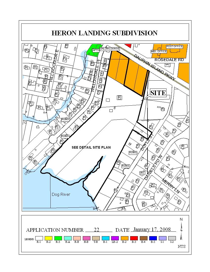
1 HERON LANDING SUBDIVISION Engineering Comments: Per FEMA guidelines, any development greater than 5 acres in size or subdivision 50 lots in size, requires a flood study. Width of drainage easement to be approved by City Engineering before final plat is signed. Per residents input, the existing drainage channel needs to be cleaned, as water currently ponds during rain events. Per storm water ordinance, land-disturbing activity cannot increase runoff on adjacent property. It is the responsibility of the applicant to look up the site in the City of Mobile (COM) GIS system and verify if NWI wetlands are depicted on the site. If the COM GIS shows wetlands on the site, it is the responsibility of the applicant to confirm or deny the existence of wetlands onsite. If wetlands are present, they should be depicted on plans and/or plat, and no work/disturbance can be performed without a permit from the Corps of Engineers. Must comply with all storm water and flood control ordinances. Any work performed in the right of way will require a right of way permit. Traffic Engineering Comments: Driveway number, sizes, location and design to be approved by Traffic Engineering and ALDOT, and conform to AASHTO standards. Urban Forestry Comments: Property to be developed in compliance with state and local laws that pertain to tree preservation and protection on both city and private properties (State Act and City Code Chapters 57 and 64). Fire-Rescue Department Comments: All projects must comply with the requirements of the 2003 International Fire Code, including Appendices B through D, as adopted by the City of Mobile, and the 2003 International Existing Building Code, as appropriate. Subdivisions which include new cul-de-sacs longer than 150 feet must comply with the design requirements of Appendix D of the 2003 International Fire Code, as adopted by the City of Mobile. The plat illustrates the proposed acre, 20 lot subdivision which is located at the South side of Dauphin Island Parkway, 70 + East of Willowdale Street, extending to the West side of Doyle Street, South of Dauphin Island Parkway, and is in Council District 4. The applicant states that the subdivision is served by public water and sanitary sewer. The applicant intends to resubdivide five lots into a twenty-lot subdivision, which will include six lots fronting onto Dog River, and a large common area that will encompass an existing canal and wetlands area on the site. A subdivision application proposing the exact same configuration was approved by the Planning Commission at its July 20, 2006 meeting, however, the approval has since expired. The approval, which required a waiver of Section V.D.3., was subject to the following conditions: 1) depiction and labeling of all drainage and sanitary sewer easements on the final plat; 2) depiction and labeling of FEMA flood zones and required finished floor elevation information on the final plat; 3) revision of the plat to include the phrase future development across all lots not proposed for inclusion in first phase of the subdivision; - 1 -
2 4) placement of a note on the final plat stating that proposed lots shall not be recorded until the zoning issues for lots 18 and 19 are resolved; 5) placement of a note on the plat stating that lot 5 is denied access to Doyle Street, and that lot 1 is denied direct access to Dauphin Island Parkway; 6) placement of a note on the plat stating that lot 20 is denied direct access to the proposed street, if it remains commercially zoned, and that the number, size and location of any curb-cuts onto Dauphin Island Parkway must be approved by Traffic Engineering and ALDOT, and conform to AASHTO standards, however, if lot 20 is rezoned to a residential designation, it shall be denied access to Dauphin Island Parkway; 7) revision of the plat to depict a 55-foot setback line, as measured from the centerline of Doyle Street, for lot 5; 8) revision of the plat to depict the 25-foot minimum building setback line from the right-of-way for all lots; 9) placement of a note on the final plat stating that the design and location of the proposed road intersection with Dauphin Island Parkway be approved by Traffic Engineering and ALDOT, and conform to AASHTO standards; 10) placement of a note on the final plat stating that approval of all applicable federal, state and local agencies is required prior to the issuance of any permits or land disturbance activities; and 11) full compliance with all other municipal codes and ordinances. The plat currently under consideration does not reflect many of these conditions of approval. During the previous application, the applicant s representative stated that the site will be developed in phases, with the first phase including the construction of the proposed road and the recording of lots 8 11, which face Dog River. It appears that the applicant has moved forward with obtaining permission from the U. S. Army Corps of Engineers and the Alabama Department of Environmental Management regarding the mitigation of wetlands for a portion of the development, however, staff does not know if final approvals have been secured. The site fronts on Dauphin Island Parkway, a major street with adequate right-of-way, and has a portion of the site abutting Doyle Street, a minor street lacking curb and gutter. The existing right-of-way for Doyle Street where the site abuts it is 50-feet, which is not adequate due to the street lacking curb and gutter. Since Doyle Street dead-ends at Dog River, and due to the limited number of homes served by the street, it is recommended that the minimum building setback from Doyle Street for the site in question be increased to provide 55 feet, as measured from the centerline of Doyle Street. Access to Doyle Street from Lot 5 should be denied, as indicated on the plat. The proposed Lot 1 has frontage on both the proposed residential street and Dauphin Island Parkway. The frontage on Dauphin Island Parkway is only 25-feet, and no justification is provided for the 25 by 320 foot long strip to be part of the proposed Lot 1, however, the adjacent property is under separate ownership, thus it cannot be required to be a part of the current application. Primary access to the site will be via a proposed public street that intersects Dauphin Island Parkway. Since Dauphin Island Parkway is major street and an ALDOT facility, there are access - 2 -
3 concerns. It should be noted that the roadway intersection with Dauphin Island Parkway must be approved by Traffic Engineering and ALDOT, and conform to AASHTO standards. Due to the limited frontage of all proposed lots, each lot should be limited to one curb-cut, with the size, design and location to be approved by Traffic Engineering and in conformance with AASHTO standards. Proposed Lot 1 should be denied direct access to Dauphin Island Parkway, as depicted by the note on the preliminary plat. Proposed Lot 20 should be denied direct access onto Dauphin Island Parkway if is to be used residentially (and appropriately rezoned), otherwise its one curb-cut may be to Dauphin Island Parkway, subject to approval by Traffic Engineering and ALDOT. It appears that the cul-de-sac design, as proposed, does not comply with the 2003 International Fire Code, as adopted by the City of Mobile. The road layout should be redesigned to ensure compliance: the cul-de-sac diameter should be revised to provide a 120-foot diameter right-ofway. The 25-foot minimum building setback line from the right-of-way edge is not depicted for all proposed lots (with the exception of Lot 5), and will be required (from the right-of-way setback) on the final plat. The site was the subject of two subdivision cases and a rezoning case in 2002, all of which were approved. The final plats for the subdivisions were recorded, and the rezoning was approved by City Council with conditions. The rezoning case changed the front portion of the site from R-1, One-Family Residence District, to B-2, Neighborhood Business District, however, none of the conditions for approval of the rezoning have been met, and that portion of the site has not been developed. The proposed subdivision will create a split-zoning condition for Lot 18, and the applicant s representative requested during the July 2006 application that the split-zoning issue identified for lot 18 be resolved at a future date, before that phase of the proposed subdivision is recorded. The current plat does not depict any phasing. Therefore, the plat should be revised to depict the proposed first phase, and the remaining lots should additionally be labeled as future development. Furthermore, a note should be placed on the final plat, if approved, stating that proposed lots shall not be recorded until the split-zoning condition of lot 18 is resolved. Proposed Lots 6 11 do not comply with the recommended depth to width ratio in Section V.D.3. of the Subdivision Regulations. Due to the proximity to Dog River and the potential presence of wetlands, a waiver of Section V.D.3. may be appropriate. It should also be noted that the final plats for the subdivisions approved in 2002 depicted drainage easements and sanitary sewer easements that may not be depicted on the current application s preliminary plat. The plat should be revised to show all easements that occur on the site, as they may affect the applicant s ability to develop the site. It should also be pointed out that research provided by an abutting property owner clearly shows that there is a public drainage easement crossing the site from Dauphin Island Parkway to Dog River: the drainage easement has not been maintained, thus flooding and ponding on the site is affecting neighboring properties. The Southern portion of the site is bounded by Dog River, and the site is partially bisected by a canal that connects to an existing drainage easement. Wetlands associated with Dog River may - 3 -
4 occur on a portion of the site. The site, additionally, appears to be partially located in the 100 and 500 year flood zones, as depicted on FEMA maps. The site also appears to be in an area subject to hurricane-related storm surge. The presence of wetlands and floodplains indicate that the area may be environmentally sensitive; therefore, the approval of all applicable federal, state and local agencies would be required prior to the issuance of any permits or land disturbance activities. The applicant has initiated a wetlands mitigation approval process, but staff is not aware if final approval has been obtained. It should also be pointed out that staff has become aware of FEMA requirements for flood studies, and this proposed subdivision will apparently require compliance with the FEMA requirements. The geographic area defined by the city of Mobile and its planning jurisdiction, including this site, may contain Federally-listed threatened or endangered species as well as protected nongame species. Development of the site must be undertaken in compliance with all local, state and Federal regulations regarding endangered, threatened or otherwise protected species. Based on the preceding, this application is recommended for Tentative Approval, subject to the following conditions: 1) Compliance with Engineering requirements (Per FEMA guidelines, any development greater than 5 acres in size or subdivision 50 lots in size, requires a flood study. Width of drainage easement to be approved by City Engineering before final plat is signed. Per residents input, the existing drainage channel needs to be cleaned, as water currently ponds during rain events. Per storm water ordinance, land-disturbing activity cannot increase runoff on adjacent property. It is the responsibility of the applicant to look up the site in the City of Mobile (COM) GIS system and verify if NWI wetlands are depicted on the site. If the COM GIS shows wetlands on the site, it is the responsibility of the applicant to confirm or deny the existence of wetlands on-site. If wetlands are present, they should be depicted on plans and/or plat, and no work/disturbance can be performed without a permit from the Corps of Engineers. Must comply with all storm water and flood control ordinances. Any work performed in the right of way will require a right of way permit.); 2) Compliance with Fire-Rescue comments (All projects must comply with the requirements of the 2003 International Fire Code, including Appendices B through D, as adopted by the City of Mobile, and the 2003 International Existing Building Code, as appropriate. Subdivisions which include new cul-de-sacs longer than 150 feet must comply with the design requirements of Appendix D of the 2003 International Fire Code, as adopted by the City of Mobile.) 3) Depiction and labeling of FEMA flood zones and required finished floor elevation information on the final plat; 4) Revision of the plat to include the phrase future development across all lots not proposed for inclusion in first phase of the subdivision; 5) Placement of a note on the final plat stating that proposed lots shall not be recorded until the zoning issues for lots 18 and 19 are resolved; 6) Placement of a note on the plat stating that lot 5 is denied access to Doyle Street, and that lot 1 is denied direct access to Dauphin Island Parkway; 7) Placement of a note on the plat stating that all Lots 1-19 are limited to one curb-cut, with the size, design and location to be approved by Traffic Engineering and in conformance with AASHTO standards, and that Lot 20 is limited to one curb-cut, with the size, design and location to be approved by Traffic Engineering and ALDOT, and conform to AASHTO - 4 -
5 standards, however, if lot 20 is rezoned to a residential designation, it shall be denied direct access to Dauphin Island Parkway; 8) Placement of a note on the final plat stating that the design and location of the proposed road intersection with Dauphin Island Parkway be approved by Traffic Engineering and ALDOT, and conform to AASHTO standards; 9) Revision of the plat to depict a 55-foot setback line, as measured from the centerline of Doyle Street, for lot 5, and revision of the plat to depict the 25-foot minimum building setback line from the right-of-way for all other lots; 10) Placement of a note on the final plat stating that approval of all applicable Federal, state and local agencies is required for wetlands and floodplains prior to the issuance of any permits or land disturbance activities; 11) Placement of a note on the plat stating that approval of all applicable Federal, state and local agencies is required for endangered, threatened or otherwise protected species, if any, prior to the issuance of any permits or land disturbance activities; 12) The labeling of the lots with their size in square feet, or placement of the same information in a table on the final plat; and 13) Full compliance with all other municipal codes and ordinances
6 - 6 -
7 - 7 -
8 - 8 -
AUTUMNDALE SUBDIVISION, RESUBDIVISION OF LOTS
 AUTUMNDALE SUBDIVISION, RESUBDIVISION OF LOTS 100-102 Engineering Comments: Road shall be constructed per City standards and according to the City s street acceptance process. Cul-de sac approval subject
KLUGE PLACE SUBDIVISION
 KLUGE PLACE SUBDIVISION Engineering Comments: Must comply with the Mobile County Flood Damage Prevention Ordinance. Development shall be designed to comply with the storm water detention and drainage facility
COCHRAN FAMILY RIVERSIDE ESTATE SUBDIVISION
 # 19 SUB2012-00111 COCHRAN FAMILY RIVERSIDE ESTATE SUBDIVISION Engineering Comments: The following comments should be addressed prior to review, acceptance and signature by the City Engineer: 1. Label/show
MOBILE TOWERS SUBDIVISION
 # 3 SUB2014-00100 MOBILE TOWERS SUBDIVISION Engineering Comments: The following comments should be addressed prior to submitting the FINAL PLAT for acceptance and signature by the City Engineer: 1) Provide
# 14 SUB CANAL SUBDIVISION
 CANAL SUBDIVISION Engineering Comments: Label each Lot showing the required minimum finished floor elevation (MFFE). It appears that Lots 2, 3 & 4 are located in the AE Flood Zone; add a note to the plat
SOUTHERN INDUSTRIAL PARK SUBDIVISION, LOT A, RESUBDIVISION OF LOTS 7 & 8
 SOUTHERN INDUSTRIAL PARK SUBDIVISION, LOT A, RESUBDIVISION OF LOTS 7 & 8 Engineering Comments: Need to increase width of existing easement to include an area at least 20 from the top of the existing ditch,
MAGNOLIA SPRINGS SUBDIVISION, PHASE ONE
 MAGNOLIA SPRINGS SUBDIVISION, PHASE ONE Engineering Comments: Must comply with the Mobile County Flood Damage Prevention Ordinance. Development shall be designed to comply with the storm water detention
TURTLE CREEK SUBDIVISION, PHASE THREE
 TURTLE CREEK SUBDIVISION, PHASE THREE Engineering Comments: Must comply with the Mobile County Flood Damage Prevention Ordinance. Development shall be designed to comply with the storm water detention
KRONER S MOBILE WEST COMMERCIAL BUSINESS PARK SUBDIVISION
 KRONER S MOBILE WEST COMMERCIAL BUSINESS PARK SUBDIVISION Engineering Comments: Must comply with the Mobile County Flood Damage Prevention Ordinance. Development shall be designed to comply with the storm
DAUPHIN CREEK ESTATES SUBDIVISION
 # 12 SUB-000076-2017 DAUPHIN CREEK ESTATES SUBDIVISION Engineering Comments: FINAL PLAT COMMENTS (should be addressed prior to submitting the FINAL PLAT for review and/or signature by the City Engineer):
# 1 HOLDOVER Revised SUB CANAL SUBDIVISION
 CANAL SUBDIVISION Engineering Comments: Label each Lot showing the required minimum finished floor elevation (MFFE). It appears that Lots 2, 3 & 4 are located in the AE Flood Zone; add a note to the plat
AMELIA LAKE SUBDIVISON, PHASES 1-2
 # 1 HOLDOVER Revised SUB2014-00089 AMELIA LAKE SUBDIVISON, PHASES 1-2 Engineering Comments: Must comply with the Mobile County Flood Damage Prevention Ordinance. Development shall be designed to comply
BETTA STOR-IT SUBDIVISION
 BETTA STOR-IT SUBDIVISION Engineering Comments: Must comply with all storm water and flood control ordinances. Any increase in impervious area in excess of 4,000 square feet will require detention. Any
PLANNED UNIT DEVELOPMENT, SIDEWALK WAIVER, & SUBDIVISION STAFF REPORT Date: November 6, 2008
 PLANNED UNIT DEVELOPMENT, SIDEWALK WAIVER, & SUBDIVISION STAFF REPORT Date: November 6, 2008 DEVELOPMENT NAME SUBDIVISION NAME LOCATION Frascati Shops, Inc. Frascati Subdivision 1120 Paper Mill Road CITY
PROVISION POINTE SUBDIVISION
 PROVISION POINTE SUBDIVISION Engineering Comments: Must comply with the Mobile County Flood Damage Prevention Ordinance. Development shall be designed to comply with the storm water detention and drainage
THE BLUFFS AT CYPRESS CREEK SUBDIVISION, PHASE ONE
 THE BLUFFS AT CYPRESS CREEK SUBDIVISION, PHASE ONE Engineering Comments: Shipyard Road shall be constructed to City Standard up through proposed Cypress Park Drive. Show Minimum FFE on plans and plat.
ZONING AMENDMENT & SUBDIVISION STAFF REPORT Date: July 3, 2014
 ZONING AMENDMENT & SUBDIVISION STAFF REPORT Date: July 3, 2014 APPLICANT NAME SUBDIVISION NAME LOCATION Georgia Crown Distributing Subdivision Georgia Crown Distributing Subdivision Southwest corner of
PENNY LAKES SUBDIVISION
 PENNY LAKES SUBDIVISION Engineering Comments: A portion of the site may be located within the J.B. Converse watershed, the primary drinking water supply for the Mobile Area Water and Sewer System. Consultation
DEER RIVER COMMERCIAL PARK SUBDIVISION
 DEER RIVER COMMERCIAL PARK SUBDIVISION Engineering Comments: Must comply with the Mobile County Flood Damage Prevention Ordinance. Development shall be designed to comply with the storm water detention
ALBA BEACH SUBDIVISION, RESUBDIVISION OF LOT 17
 ALBA BEACH SUBDIVISION, RESUBDIVISION OF LOT 17 Engineering Comments: FINAL PLAT COMMENTS (should be addressed prior to submitting the FINAL PLAT for acceptance and signature by the City Engineer): A.
ZONING AMENDMENT, PLANNED UNIT DEVELOPMENT & SUBDIVISION STAFF REPORT Date: March 5, 2009
 ZONING AMENDMENT, PLANNED UNIT DEVELOPMENT & SUBDIVISION STAFF REPORT Date: March 5, 2009 NAME SUBDIVISION NAME LOCATION Kentress Morrisette Booker T. Washington Highlands Subdivision, First Addition,
ZONING AMENDMENT & SUBDIVISION STAFF REPORT Date: March 7, 2013
 # 4 & 5 SUB2012-00141 & ZON2012-03157 HOLDOVER ZONING AMENDMENT & SUBDIVISION STAFF REPORT Date: March 7, 2013 APPLICANT NAME SUBDIVISION NAME LOCATION Garrard Development Services, LLC Michigan & Bay
DINKINS ESTATE FAMILY SUBDIVISION
 # 9 SUB2015-00122 DINKINS ESTATE FAMILY SUBDIVISION Engineering Comments: The following comments should be addressed prior to submitting the FINAL PLAT for acceptance and signature by the City Engineer:
NOBLE DRIVE EAST SUBDIVISION
 NOBLE DRIVE EAST SUBDIVISION Engineering Comments: Must comply with the Mobile County Flood Damage Prevention Ordinance. Development shall be designed to comply with the storm water detention and drainage
DAWES SWITCHING STATION SUBDIVISION
 DAWES SWITCHING STATION SUBDIVISION Engineering Comments: Must comply with the Mobile County Flood Damage Prevention Ordinance. Development shall be designed to comply with the storm water detention and
JOHNNY S RV PARK SUBDIVISION
 # 11 SUB2016-00001 JOHNNY S RV PARK SUBDIVISION Engineering Comments: The following comments should be addressed prior to submitting the FINAL PLAT for acceptance and signature by the City Engineer: A.
ZONING AMENDMENT, PLANNED UNIT DEVELOPMENT & SUBDIVISION STAFF REPORT Date: August 8, 2013
 ZONING AMENDMENT, PLANNED UNIT DEVELOPMENT & SUBDIVISION STAFF REPORT Date: August 8, 2013 NAME SUBDIVISION NAME PV-Magnolia, LLC Twelve Trees Subdivision LOCATION 2860, 2862 and 2866 Pleasant Valley Road
PLANNED UNIT DEVELOPMENT & SUBDIVISION STAFF REPORT Date: March 15, 2007
 PLANNED UNIT DEVELOPMENT & SUBDIVISION STAFF REPORT Date: March 15, 2007 DEVELOPMENT NAME SUBDIVISION NAME LOCATION Motormax Subdivision Motormax Subdivision 2917 and 2929 Government Boulevard (South side
ZONING AMENDMENT, & SUBDIVISION STAFF REPORT Date: July 24, 2008
 ZONING AMENDMENT, & SUBDIVISION STAFF REPORT Date: July 24, 2008 APPLICANT NAME SUBDIVISION NAME Remax Realty Professionals Star Motel Subdivision LOCATION 2005 and 2009 Douglas Lane (Southwest corner
WESTMINSTER PARK PLACE SUBDIVISION
 WESTMINSTER PARK PLACE SUBDIVISION Engineering Comments: FINAL PLAT COMMENTS (should be addressed prior to submitting the FINAL PLAT for review and/or signature by the City Engineer): A. Provide all of
ZONING AMENDMENT & SUBDIVISION STAFF REPORT Date: July 9, 2015
 ZONING AMENDMENT & SUBDIVISION STAFF REPORT Date: July 9, 2015 APPLICANT NAME 2513 Dauphin Street, Inc. SUBDIVISION NAME Audubon Place Extension No. 3, Resubdivision of Lots 1-5 LOCATION 2513 Dauphin Street
WESTMINSTER PARK SUBDIVISION
 WESTMINSTER PARK SUBDIVISION Engineering Comments: FINAL PLAT COMMENTS (should be addressed prior to submitting the FINAL PLAT for review and/or signature by the City Engineer): A. Provide all of the required
PLANNED UNIT DEVELOPMENT & SUBDIVISION STAFF REPORT August 18, 2016
 PLANNED UNIT DEVELOPMENT & SUBDIVISION STAFF REPORT August 18, 2016 DEVELOPMENT NAME SUBDIVISION NAME Mullinax Ford Subdivision Mullinax Ford Subdivision LOCATION CITY COUNCIL DISTRICT District 6 Southeast
McGowin Park, LLC. B-3, Community Business District
 # 10, 11, 12 SUB2014-00024 ZON2014-00500 ZON2014-00501 SUBDIVISION, PLANNED UNIT DEVELOPMENT (East), PLANNED UNIT DEVELOPMENT (West) STAFF REPORT Date: April 3, 2014 DEVELOPMENT NAME LOCATION McGowin Park,
PLANNED UNIT DEVELOPMENT & ZONING AMENDMENT STAFF REPORT Date: December 21, 2017
 # 14 PUD-000324-2017 & ZON-000326-2017 PLANNED UNIT DEVELOPMENT & ZONING AMENDMENT STAFF REPORT Date: December 21, 2017 APPLICANT NAME DEVELOPMENT NAME LOCATION Dewberry/Preble-Rish Longleaf Gates Subdivision,
ZONING AMENDMENT, PLANNED UNIT DEVELOPMENT & SUBDIVISION STAFF REPORT Date: September 15, 2011
 ZONING AMENDMENT, PLANNED UNIT DEVELOPMENT & SUBDIVISION STAFF REPORT Date: September 15, 2011 NAME SUBDIVISION NAME LOCATION Stratford, L.L.C. Grelot Office Park Subdivision North side of Grelot Road,
BAY FOREST PARK SUBDIVISION, RESUBDIVISION OF LOTS 6 & 7 AND BAY FOREST PARK SUBDIVISION LOT 10, OF THE RESUBDIVISON OF LOTS 9 & 10
 BAY FOREST PARK SUBDIVISION, RESUBDIVISION OF LOTS 6 & 7 AND BAY FOREST PARK SUBDIVISION LOT 10, OF THE RESUBDIVISON OF LOTS 9 & 10 Engineering Comments: Must comply with the Mobile County Flood Damage
SUBDIVISION, PLANNED UNIT DEVELOPMENT, & PLANNING APPROVAL STAFF REPORT Date: February 1, 2007
 SUBDIVISION, PLANNED UNIT DEVELOPMENT, & PLANNING APPROVAL STAFF REPORT Date: February 1, 2007 DEVELOPMENT NAME SUBDIVISION NAME Pala Verde Mobile Home Park Subdivision Pala Verde Mobile Home Park Subdivision
SUBDIVISION, PLANNED UNIT DEVELOPMENT, PLANNING APPROVAL, ZONING AMENDMENT, & SIDEWALK WAIVER REQUEST STAFF REPORT Date: February 17, 2010
 SUBDIVISION, PLANNED UNIT DEVELOPMENT, PLANNING APPROVAL, ZONING AMENDMENT, & SIDEWALK WAIVER REQUEST STAFF REPORT Date: February 17, 2010 APPLICANT NAME SUBDIVISION NAME DEVELOPMENT NAME LOCATION David
APPLICANT NAME SUBDIVISION NAME DEVELOPMENT NAME LOCATION. CITY COUNCIL DISTRICT Council District 4 PRESENT ZONING PROPOSED ZONING
 SUBDIVISION, PLANNED UNIT DEVELOPMENT, PLANNING APPROVAL, ZONING AMENDMENT, & SIDEWALK WAIVER REQUEST STAFF REPORT Date: February 17, 2010 APPLICANT NAME SUBDIVISION NAME DEVELOPMENT NAME LOCATION David
PLANNED UNIT DEVELOPMENT & SUBDIVISION STAFF REPORT Date: July 20, 2017
 PLANNED UNIT DEVELOPMENT & SUBDIVISION STAFF REPORT Date: July 20, 2017 DEVELOPMENT NAME SUBDIVISION NAME LOCATION Rangeline Crossing III Subdivision Rangeline Crossing III Subdivision 5289 Halls Mill
MCGOWIN PARK EAST OF SATCHEL PAIGE SUBDIVISION, RESUBDIVISION OF
 # 14 SUB2015-00058 MCGOWIN PARK EAST OF SATCHEL PAIGE SUBDIVISION, RESUBDIVISION OF Engineering Comments: The following comments should be addressed prior to submitting the FINAL PLAT for acceptance and
TERRY POIROUX FAMILY DIVISION SUBDIVISION
 TERRY POIROUX FAMILY DIVISION SUBDIVISION Engineering Comments: Must comply with the Mobile County Flood Damage Prevention Ordinance. Development shall be designed to comply with the storm water detention
PALMER WOODS SUBDIVISION, PHASE III
 PALMER WOODS SUBDIVISION, PHASE III Engineering Comments: Must comply with the Mobile County Flood Damage Prevention Ordinance. MAWSS Comments: MAWSS has NO water and sewer services available. The plat
ZONING AMENDMENT, PLANNED UNIT DEVELOPMENT & PLANNING APPROVAL STAFF REPORT Date: June 7, 2007
 ZONING AMENDMENT, PLANNED UNIT DEVELOPMENT & PLANNING APPROVAL STAFF REPORT Date: June 7, 2007 NAME LOCATION Johnny Randall Cotton and Angela K. Cotton 4800 Tufts Road (West side of Tufts Road, 50 ± North
ZONING AMENDMENT & SUBDIVISION STAFF REPORT Date: November 3, 2016
 ZONING AMENDMENT & SUBDIVISION STAFF REPORT Date: November 3, 2016 APPLICANT NAME SUBDIVISION NAME David Shumer 5955 Airport Subdivision CITY COUNCIL DISTRICT District 6 5955 Airport Boulevard, 754 Linlen
PLANNED UNIT DEVELOPMENT & SUBDIVISION STAFF REPORT Date: November 17, 2016
 PLANNED UNIT DEVELOPMENT & SUBDIVISION STAFF REPORT Date: November 17, 2016 DEVELOPMENT NAME SUBDIVISION NAME LOCATION Autonation Ford of Mobile Autonation Ford of Mobile Subdivision 901, 909, and 925
PLANNED UNIT DEVELOPMENT & SUBDIVISION STAFF REPORT Date: September 15, 2016
 # 10 SUB2016-00089 PLANNED UNIT DEVELOPMENT & SUBDIVISION STAFF REPORT Date: September 15, 2016 NAME SUBDIVISION NAME LOCATION Lot 12 Laughlin Industrial Park Subdivision Lot 12 Laughlin Industrial Park
ZONING AMENDMENT & SUBDIVISION STAFF REPORT Date: June 18, 2015
 ZONING AMENDMENT & SUBDIVISION STAFF REPORT Date: June 18, 2015 APPLICANT NAME SUBDIVISION NAME EAA LLC / Eryka Rogers Aaiden Place Subdivision LOCATION 2480 Government Boulevard (North side of Government
THE CITY OF MOBILE, ALABAMA MOBILE Crry PLANNING COMMISSION
 THE CITY OF MOBILE, ALABAMA MOBILE Crry PLANNING COMMISSION LETTER OF DECISION MLK Avenue Redevelopment Corp. Attn: Michael Pierce P.O. Box 2204 Mobile, AL 36652 Re: Case #SUB2014-00040 (Subdivision) MLK
TULSA PARK ESTATES SUBDIVISION, RESUBDIVISION OF LOT 6
 TULSA PARK ESTATES SUBDIVISION, RESUBDIVISION OF LOT 6 Engineering Comments: FINAL PLAT COMMENTS (should be addressed prior to submitting the FINAL PLAT for review and/or signature by the City Engineer):
PORT CITY COMMERCE PARK SUBDIVISION
 # 4 SUB2015-00019 PORT CITY COMMERCE PARK SUBDIVISION Engineering Comments: Must comply with the Mobile County Flood Damage Prevention Ordinance. Development shall be designed to comply with the storm
MTC ALABAMA SUBDIVISION
 # 2 SUB-000370-2017 MTC ALABAMA SUBDIVISION Engineering Comments: FINAL PLAT COMMENTS (should be addressed prior to submitting the FINAL PLAT for review and/or signature by the City Engineer): A. Provide
HAWTHORNE PLACE SUBDIVISON, RESUBDIVISION OF LOT 15 REVISED
 # 10 SUB-000336-2017 HAWTHORNE PLACE SUBDIVISON, RESUBDIVISION OF LOT 15 REVISED Engineering Comments: FINAL PLAT COMMENTS (should be addressed prior to submitting the FINAL PLAT for review and/or signature
VIKING PLACE SUBDIVISION, PHASE II
 VIKING PLACE SUBDIVISION, PHASE II Engineering Comments: Must comply with the Mobile County Flood Damage Prevention Ordinance. The plat illustrates the proposed 22 lot, 7.2 + acre subdivision which is
SUBDIVISION, PLANNING APPROVAL, & REZONING STAFF REPORT Date: June 4, 2015
 SUBDIVISION, PLANNING APPROVAL, & REZONING STAFF REPORT Date: June 4, 2015 APPLICANT NAME SUBDIVISION NAME DEVELOPMENT NAME LOCATION Board of Water & Sewer Commissioners of the City of Mobile MAWSS MLK
BROADWAY THREE NOTCH ROAD SUBDIVISION
 # 3 SUB-000803-2018 BROADWAY THREE NOTCH ROAD SUBDIVISION Engineering Comments: FINAL PLAT COMMENTS (should be addressed prior to submitting the FINAL PLAT for review and/or signature by the City Engineer):
SUBDIVISION & PLANNING APPROVAL STAFF REPORT Date: December 1, 2016
 SUBDIVISION & PLANNING APPROVAL STAFF REPORT Date: December 1, 2016 APPLICANT NAME SUBDIVISION NAME DEVELOPMENT NAME LOCATION Board of Water and Sewer Commissioners of the City of Mobile Halls Mill Road
SUBDIVISION, PLANNED UNIT DEVELOPMENT, ZONING AMENDMENT, & SIDEWALK WAIVER STAFF REPORT Date: July 19, 2018
 SUBDIVISION, PLANNED UNIT DEVELOPMENT, ZONING AMENDMENT, & SIDEWALK WAIVER STAFF REPORT Date: July 19, 2018 NAME SUBDIVISION NAME LOCATION West Mobile Properties, LLC U.S. Machine Subdivision 556, 566,
THE BLUFFS AT CYPRESS CREEK SUBDIVISION
 THE BLUFFS AT CYPRESS CREEK SUBDIVISION Engineering Comments: Must comply with all stormwater and flood control ordinances. Any work performed in the right-of-way will require a right-of-way permit. Traffic
STONE HEDGE SUBDIVISION, UNIT 1, RESUBDIVISION OF LOT 40 & WEST COMMON AREA
 # 5 SUB-000498-2018 STONE HEDGE SUBDIVISION, UNIT 1, RESUBDIVISION OF LOT 40 & WEST COMMON AREA Engineering Comments: Must comply with the Mobile County Flood Damage Prevention Ordinance. Development shall
# 6 Case #SUB LEGACY SUBDIVISION. Engineering Comments: Must comply with the Mobile County Flood Damage Prevention Ordinance.
 LEGACY SUBDIVISION Engineering Comments: Must comply with the Mobile County Flood Damage Prevention Ordinance. The plat illustrates the proposed 46 lot, 26.7 + acres subdivision which is located on the
THE WHEELER BUILDING SUBDIVISION
 THE WHEELER BUILDING SUBDIVISION Engineering Comments: FINAL PLAT COMMENTS (should be addressed prior to submitting the FINAL PLAT for review and/or signature by the City Engineer): A. Provide all of the
PLANNED UNIT DEVELOPMENT (East), PLANNED UNIT DEVELOPMENT (West) STAFF REPORT Date: September 18, 2014
, PLANNED UNIT DEVELOPMENT (West) STAFF REPORT Date: September 18, 2014") PLANNED UNIT DEVELOPMENT (East), PLANNED UNIT DEVELOPMENT (West) STAFF REPORT Date: September 18, 2014 DEVELOPMENT NAME LOCATION McGowin Park, LLC PLANNED UNIT DEVELOPMENT (East) 1401 Satchel Paige Drive
PLANNED UNIT DEVELOPMENT (East), PLANNED UNIT DEVELOPMENT (West) STAFF REPORT Date: September 18, 2014 DEVELOPMENT NAME LOCATION McGowin Park, LLC PLANNED UNIT DEVELOPMENT (East) 1401 Satchel Paige Drive
AMENDMENT TO REGULATING PLAN & SUBDIVISION STAFF REPORT Date: December 15, 2016
 AMENDMENT TO REGULATING PLAN & SUBDIVISION STAFF REPORT Date: December 15, 2016 NAME SUBDIVISION NAME Gulf States Engineering- Mathew C. Roberts, PLS Precision Engineering Subdivision LOCATION CITY COUNCIL
PLANNED UNIT DEVELOPMENT & SUBDIVISION STAFF REPORT Date: April 18, 2019
 PLANNED UNIT DEVELOPMENT & SUBDIVISION STAFF REPORT Date: April 18, 2019 DEVELOPMENT NAME SUBDIVISION NAME Springhill Village Subdivision Springhill Village Subdivision LOCATION 4350, 4354, 4356, 4358,
THE CITY OF MOBILE, ALABAMA
 THE CITY OF MOBILE, ALABAMA LETTER OF DECISION Dewberry I Preble-Rish 9949 Bellaton Avenue Daphne, AL 36526 Re: 6050 & 6086 Whitebark Drive (North side of Girby Road, 125'± East of Bristlecone Drive, extending
DAWES OAK SUBDIVISION
 DAWES OAK SUBDIVISION Engineering Comments: Must comply with the Mobile County Flood Damage Prevention Ordinance. The plat illustrates the proposed 82-lot, 28.1± acre subdivision, which is located on the
MOBILE CITY PLANNING COMMISSION LETTER OF DECISION. June 3, 2011
 MOBILE CITY PLANNING COMMISSION LETTER OF DECISION P.O. Box 421 Mobile, AL 36601 Re: Case #SUB2011-00029 (Subdivision) Alabama West Subdivision, Unit Four 2600 McVay Drive North (North side of McVay Drive
ZONING AMENDMENT, & SUBDIVISION STAFF REPORT Date: May 17, 2007
 ZONING AMENDMENT, & SUBDIVISION STAFF REPORT Date: May 17, 2007 APPLICANT NAME SUBDIVISION NAME LOCATION Christopher J. Nix, Agent Mobile Central Subdivision 2570, 2590, & 2598 Government Boulevard (Northeast
THE CI FY OF MOBILE, ALABAMA
 THE CI FY OF MOBILE, ALABAMA LETTER OF DECISION DewberryiPreble-Rish 9949 Bellaton Avenue Daphne, AL 36526 Re: Area bounded by Foxtail Drive, Lace Bark Drive and Whitebark Drive Council District 6 SUB-000323-2017
ZONING AMENDMENT & SUBDIVISION STAFF REPORT Date: March 1, 2018
 #13 SUB-000406-2018 & ZON-000407-2018 ZONING AMENDMENT & SUBDIVISION STAFF REPORT Date: March 1, 2018 NAME SUBDIVISION NAME LOCATION Creekside @ Kooiman Dairy Creekside @ Kooiman Dairy Subdivision (South
PARK PLACE SUBDIVISION
 PARK PLACE SUBDIVISION Engineering Comments: Must comply with the Mobile County Flood Damage Prevention Ordinance. The plat illustrates the proposed 53 lot, 12.6 + acres subdivision which is located on
THE CITY OF MOBILE, ALABAMA
 THE CITY OF MOBILE, ALABAMA LETTER OF DECISION March 9, 2018 Byrd Surveying, Inc. 2609 Halls Mill Road Mobile, AL 36606 Re: 4439 Rangeline Road (Northwest corner of Rangeline Road and Halls Mill Road).
THE CITY OF MOBILE, ALABAMA
 THE CITY OF MOBILE, ALABAMA LE 'I IER OF DECISION Kimberly Clark Mobile Operations 200 Africatown Blvd. Prichard, AL 36610 Re: 100 & 200 Africatown Boulevard (Northeast corner of Bay Bridge Road and Paper
MOBILE CITY PLANNING COMMISSION LETTER OF DECISION. August 19, 2011
 Case #SUB2011-00082 (Subdivision) Subdivision (West side of Demetropolis Road, 1900 + South of Cottage Hill Road). Number of Lots / Acres: 1 Lot / 12.5± Acres Engineer / Surveyor: Driven Engineering, Inc.
ELIZA JORDAN CORNER SUBDIVISION
 ELIZA JORDAN CORNER SUBDIVISION Engineering Comments: Must comply with the Mobile County Flood Damage Prevention Ordinance. Development shall be designed to comply with the storm water detention and drainage
THE CITY OF MOBILE, ALABAMA
 THE CITY OF MOBILE, ALABAMA LETTER OF DECISION Dominion Senior Living of West Mobile, LLC 1200 Corporate Dr., St. 225 Birmingham, AL 35242 Re: 6924 Somerbv Lane (North terminus of Somerby Lane). Council
SUBDIVISION, PLANNED UNIT DEVELOPMENT, & REZONING STAFF REPORT Date: September 17, 2015
 SUBDIVISION, PLANNED UNIT DEVELOPMENT, & REZONING STAFF REPORT Date: September 17, 2015 APPLICANT NAME SUBDIVISION NAME DEVELOPMENT NAME LOCATION Daniel Clark Mack Manufacturing Subdivision, Resubdivision
ZONING AMENDMENT, SUBDIVISION & SIDEWALK WAIVER REQUEST STAFF REPORT Date: November 16, 2006
 ZONING AMENDMENT, SUBDIVISION & SIDEWALK WAIVER REQUEST STAFF REPORT Date: November 16, 2006 NAME SUBDIVISION NAME Terhaar & Cronley Investment Partnership P & E Subdivision LOCATION 4210 and 4218 Halls
PLANNED UNIT DEVELOPMENT STAFF REPORT Date: October 19, 2017
 PLANNED UNIT DEVELOPMENT STAFF REPORT Date: October 19, 2017 DEVELOPMENT NAME LOCATION Custom Boat Storage 3975 Demetropolis Road (East side of Demetropolis Road, 0.2± miles South of Halls Mill Road.)
SILVER PINES SUBDIVISION
 SILVER PINES SUBDIVISION Engineering Comments: Must comply with the Mobile County Flood Damage Prevention Ordinance. The plat illustrates the proposed 39.4+ acre, 153 lot subdivision, which is located
MAGNOLIA SPRINGS SUBDIVISION, PHASE II
 MAGNOLIA SPRINGS SUBDIVISION, PHASE II Engineering Comments: Must comply with the Mobile County Flood Damage Prevention Ordinance. Development shall be designed to comply with the storm water detention
ARTICLE 3 DEFINITIONS
 Sections: 3-1 Rules of Construction 3-2 Definitions ARTICLE 3 DEFINITIONS SECTION 3-1 RULES OF CONSTRUCTION 3-101. a. The language set forth in these regulations shall be interpreted in accordance with
PLANNED UNIT DEVELOPMENT & SUBDIVISION STAFF REPORT Date: May 6, 2004
 # 3. & 4. File # ZON2004-00967 & SUB2004-00085 PLANNED UNIT DEVELOPMENT & SUBDIVISION STAFF REPORT Date: May 6, 2004 DEVELOPMENT NAME SUBDIVISION NAME Heron Lakes Subdivision, Phase One, Revised Lot 32
OAK HILL SUBDIVISION
 OAK HILL SUBDIVISION Engineering Comments: Must comply with the Mobile County Flood Damage Prevention Ordinance. MAWSS Comments: MAWSS has no water or sewer services available. The plat illustrates the
ZONING AMENDMENT & PLANNED UNIT DEVELOPMENT STAFF REPORT Date: June 7, 2012
 ZONING AMENDMENT & PLANNED UNIT DEVELOPMENT STAFF REPORT Date: June 7, 2012 NAME DEVELOPMENT NAME LOCATION Mayo Blackmon Mayo Blackmon 1446 Navco Road & 2452 McLaughlin Drive. (North side of McLaughlin
ZONING AMENDMENT & PLANNED UNIT DEVELOPMENT STAFF REPORT Date: July 5, 2012
 ZONING AMENDMENT & PLANNED UNIT DEVELOPMENT STAFF REPORT Date: July 5, 2012 NAME DEVELOPMENT NAME LOCATION Mayo Blackmon Mayo Blackmon 1446 Navco Road & 2452 McLaughlin Drive. (North side of McLaughlin
Staff Report: Date: Applicant: Property Identification: Acreage of Request: Current Zoning of Requested Area: Requested Action: Attached:
 Staff Report: Completed by Jeff Palmer Director of Planning & Zoning Date: November 7, 2018, Updated November 20, 2018 Applicant: Greg Smith, Oberer Land Developer agent for Ronald Montgomery ET AL Property
DIVISION 2 - CONSTRUCTION PLAN AND MISCELLANEOUS REQUIREMENTS
 DIVISION 2 - CONSTRUCTION PLAN AND MISCELLANEOUS REQUIREMENTS 2.1 Required Plan Sheets 2.2 Drawing Requirements 2.3 Graphic Standards 2.4 Easements 2.5 Utility Locations 2.6 Private Facility Locations
SUBDIVISION, PLANNED UNIT DEVELOPMENT, & REZONING STAFF REPORT Date: March 23, 2017
 SUBDIVISION, PLANNED UNIT DEVELOPMENT, & REZONING STAFF REPORT Date: March 23, 2017 APPLICANT NAME SUBDIVISION NAME DEVELOPMENT NAME LOCATION Sarah & Michael Stashak Old Shell at Ashland Place Subdivision
BYRON TOWNSHIP ZONING APPLICATION
 BYRON TOWNSHIP ZONING APPLICATION Phone: (616) 878-9104 * Fax: (616) 878-3980 * Website: www.byrontownship.org This application will not be accepted if incomplete. APPLICATION FOR & REQUIRED COPIES Private
Time Extension Staff Report
 Time Extension Staff Report Subdivision Name Lunara Subdivision File Number SUB07-00019 Approval Time Extension for Lead Agency Boise City Certification Signature of Boise City Engineer Annexation Date
Staff Report: Date: Applicant: Property Identification: Acreage of Request: Current Zoning of Requested Area: Requested Action: Attached:
 Staff Report: Completed by Jeff Palmer Director of Planning & Zoning Date: November 7, 2018 Applicant: Greg Smith, Oberer Land Developer agent for Ronald Montgomery ET AL Property Identification: Frontage
ARTICLE 7 UTILITIES AND EASEMENTS
 7.1 PLACEMENT OF UTILITIES ARTICLE 7 UTILITIES AND EASEMENTS 7.1.1 All authorized public underground utilities shall be located within the right-of-way of a public street or within an easement designated
ARTICLE 15. RULES, REGULATIONS AND DEFINITIONS
 ARTICLE 15. RULES, REGULATIONS AND DEFINITIONS Section 1. Interpretation and Construction: The following rules and regulations regarding interpretation and construction of the Ulysses-Grant County, Kansas,
COMMERCIAL SITE PLAN & CONDITIONAL USE PERMIT REVIEW PROCESS & CHECKLIST
 Community Development 110 South Main Street Springville, UT 84663 COMMERCIAL SITE PLAN & CONDITIONAL USE PERMIT REVIEW PROCESS & CHECKLIST 801.491.7861 www.springville.org Prior to the issuance of a building
Subdivision - Minor Plat Submittal
 Subdivision - Minor Plat Submittal This Checklist is intended to provide the information and data that is necessary to assess the merits of the project proposal. Please note that this Checklist is intended
MOBILE CITY PLANNING COMMISSION MINUTES MEETING OF JANUARY 3, :00 P.M. AUDITORIUM, MOBILE GOVERNMENT PLAZA
 MOBILE CITY PLANNING COMMISSION MINUTES MEETING OF JANUARY 3, 2008-2:00 P.M. AUDITORIUM, MOBILE GOVERNMENT PLAZA Members Present Terry Plauche, Chairman James Watkins, III William DeMouy, Secretary Debra
ORDINANCE NO. Be it ordained by the City Council of the City of Abilene, Texas:
 ORDINANCE NO. An ordinance repealing Chapter 23, Subpart B of the Code of the City of Abilene, Texas, entitled Mobile Homes and Vacation Travel Trailers; stating the authority; setting forth the scope